google.com, pub-0288379932320714, DIRECT, f08c47fec0942fa0 GRAVIR LES MONTAGNES... EN PEINTURE: New Zealand
Showing posts with label New Zealand. Show all posts

Monday, July 1, 2024

MITRE PEAK / RAHOTU  PEINT PAR   LAURENCE WILLIAM WILSON

LAURENCE WILLIAM WILSON (1851-1912) Mitre Peak/ Rahotu Nouvelle Zélande  In Aquarelle de Milford Sounds pour une série de Cartes postales d'art, New Zealand Posycard Society

LAURENCE WILLIAM WILSON (1851-1912)
Mitre Peak/ Rahotu (1,683m - 5,522 ft)
Nouvelle Zélande

In Aquarelle de Milford Sounds pour une série de Cartes postales d'art, New Zealand Posycard Society 

La montagne
Mitre Peak/ Rahotu (1,683m - 5,522 ft) est une montagne emblématique de l'île du Sud de la Nouvelle-Zélande, située sur les rives du Milford Sound. C'est l'un des sommets les plus photographiés du pays. La forme specifique du sommet du sud de la Nouvelle-Zélande donne son nom à la montagne, d'après la mitre des évêques chrétiens. Il a été nommé par le capitaine John Lort Stokes du HMS Achéron.
Une partie de la raison de son statut emblématique est son emplacement. Près des rives de Milford Sound, dans le parc national de Fiordland, au sud-ouest de l'île du Sud, c'est un spectacle époustouflant. La montagne s'élève presque verticalement depuis les eaux de Milford Sound, qui techniquement est un fjord.
Le pic est en fait un ensemble étroitement regroupé de cinq sommets, Mitre Peak n'étant même pas le plus haut, mais depuis les points de vue les plus facilement accessibles, Mitre Peak apparaît comme un seul point.
Milford Sound fait partie de Te Wahipounamu, un site du patrimoine mondial déclaré par l'UNESCO.
Le seul accès routier à Milford Sound se fait via la State Highway 94, en soi l'une des routes les plus pittoresques de Nouvelle-Zélande.

Le peintre
Laurence William Wilson émigre à Auckland en 1877, puis voyage beaucoup pour s'installer à Dunedin en 1884. Il peint à la fois à l'huile et à l'aquarelle. Il est le disciple de George O'Brien et devient enseignant. L'un de ses élèves était l'artiste de Dunedin Alfred O'Keefe. En 1895, LW Wilson avec Grace Joel, Alfred O'Keefe, Jane Wimperis et Girolami Nerli formèrent le Easel Club, une scission de l'établissement de Dunedin, qui proposait un programme de cours spéciaux et l'introduction d'un modèle professionnel pour le dessin d'après modèle.  En 1904, LW Wilson quitta Dunedin pour Melbourne où il passa 5 mois sur une peinture commandée par la ville avant de partir pour l'Angleterre, pour finalement retourner en Nouvelle-Zélande via l'Inde et l'Afrique. Il a exposé à la Canterbury Society of Arts en 1882 et à l'Otago Art Society entre 1994 et 1904. Son travail a été inclus à l'exposition NZ and South Seas de Dunedin 1889-90 et à l'exposition de St Louis en 1904. LW Wilson est présent dans les collections de toutes les principales galeries publiques de Nouvelle-Zélande.


_ ______________________________________

2024 - Gravir les montagnes en peinture
Un blog de Francis Rousseau   

Wednesday, December 13, 2023

MT SINCLAIR (NOUVELLE-ZÉLANDE)  PEINT PAR  AUSTEN DEANS


AUSTEN DEANS (1915-2011)  Mt Sinclair (841 m) Nouvelle-Zélande (Banks Peninsula)

AUSTEN DEANS (1915-2011) 
Mt Sinclair (841 m)
Nouvelle-Zélande (Banks Peninsula)

In Mt Sinclair & Mesopotamia Downs, aquarelle signée et datée 65, 35.5 x 53cm,
Courtesy Dunbar Sloan

La montagne
Le mont Sinclair (841m) est une montagne située dans la chaine des des Southern Alps en Nouvelle- Zéland. Elle offre est un des paysages les plus saisissants de la région de Canterbory  avec une vue remarquable sur la vallée supérieure de la rivière Rangitata, adossée à la chaîne Sinclair. Le mont Sinclair lui-même permet une merveilleuse ascension pour les grimpeurs les plus aguerris  sur sa face nord). La "montagne aux pointes creuses" abrite un tarn de haute montagne qui doit être l'un des meilleurs spots de baignade  au monde,  même si glacial même en été. La piste monte régulièrement en passant par des clairières de temps en temps avec de belles vues sur la péninsule d'Onawe et le port d'Akaroa. À mesure que la piste s'approche du sommet de la crête, elle devient plus rocheuse. La piste continue le long de pistes 4x4 à travers des terres agricoles et des réserves broussailleuses pendant environ une heure jusqu'au sommet du mont Sinclair. On  peut continuer vers le mont Fitzgerald et  Port Levy Saddle.

Le peintre
Alister Austen Deans était un peintre néo-zélandais, connu pour ses paysages, notamment des peintures de montagnes et pour son travail d'artiste de guerre pendant la Seconde Guerre mondiale. Né à Christchurch dans une famille d'agriculteurs bien connue, Deans s'est intéressé à l'art dès son adolescence. Il a étudié les beaux-arts à la Canterbury College School of Art avant de retourner travailler dans la ferme familiale. Il s'est porté volontaire dans le 2e corps expéditionnaire néo-zélandais lors du déclenchement de la Seconde Guerre mondiale et a été affecté au 20e bataillon. En 194, il fut nommé artiste de guerre adjoint, sous les ordres de Peter McIntyre. Il fut blessé lors de la bataille de Crète et fut détenu comme prisonnier de guerre. Autorisé à peindre pendant sa captivité, son travail constitua un témoignage sur le vif de la vie ded prisonnier. Après la guerre, il étudie la peinture au Sir John Cass Technical Institute en Angleterre avant de s'installer dans un quartier résidentiel à Canterbury. Fait Officier de l'Ordre de l'Empire britannique en 1995.

 ______________________________________

2023 - Gravir les montagnes en peinture
Un blog de Francis Rousseau  

Monday, May 1, 2023

MAUKATUA / MONT SEFTON PEINT PAR AUSTEN DEANS


AUSTEN DEANS (1915-2011)   Mont Sefton / Maukatua   (3, 151 m-10, 338 ft)   Nouvelle Zélande   In "Mt Sefton",  aquarelle, International Art Centre Auckland

AUSTEN DEANS (1915-2011)
Maukatua / Mont Sefton / (3, 151 m-10, 338 ft)
Nouvelle Zélande

In "Mt Sefton", aquarelle, International Art Centre Auckland


La montagne
Le mont Sefton / Maukatua   (3, 151 m - 10, 338 pieds) est une montagne de la chaîne Aroarokaehe des Alpes du Sud de la Nouvelle-Zélande, à seulement 12 kilomètres au sud d' Aoraki / Mount Cook. Au sud se trouve le mont Brunner , et au nord The Footstool, tous deux plus courts de plus de 400 mètres (1 300 pieds).  La montagne est bien visible depuis le village de Mount Cook dans la vallée de Hooker, avec le glacier Tuckett qui coule sur le côté sud-est de la montagne et le glacier Mueller dans la vallée en-dessous. Le mont Sefton est le 13e plus haut sommet des Alpes du Sud et la 4e plus haute montagne de Nouvelle-Zélande. Le fleuve  Douglas (anciennement connue sous le nom de  Twain) prend sa source sur le mont Sefton. Un des premiers résidents, Charles French Pemberton, a nommé la région, tandis que le géologue Julius von Haast a nommé la montagne d'après William Sefton Moorhouse, le deuxième surintendant de la province de Canterbury. Le nom maori de la montagne est Maukatua, qui se traduit par « la montagne des dieux ».
 Edward FitzGerald, avec Matthias Zurbriggen comme guide, a réalisé  la première ascension  complète enregistrée  peu après Noël 1894. 


Le peintre 
Alister Austen Deans était un peintre néo-zélandais, connu pour ses paysages et pour son travail d' artiste de guerre pendant la Seconde Guerre mondiale. Né à Christchurch dans une famille d'agriculteurs bien connue, Deans s'est intéressé à l'art dès l'adolescence. Il a étudié les beaux-arts à la Canterbury College School of Art avant de retourner travailler dans la ferme familiale. Il s'est porté volontaire pour le 2e corps expéditionnaire néo-zélandais au début de la Seconde Guerre mondiale et a été affecté au 20e bataillon. En 1941, il est nommé assistant artiste de guerre, sous la direction de Peter McIntyre. Cependant, il a été blessé lors de la bataille de Crète et est devenu prisonnier de guerre. Autorisé à peindre pendant sa captivité, son travail était un témoignage utile de la vie d'un prisonnier de guerre. Après la guerre, il étudie la peinture à Sir John Cass Technical Institute en Angleterre avant de s'installer à Canterbury. Il fut un peintre prolifique de la région des collines de Canterbury. Il a été fait Officier de l'Ordre de l'Empire britannique en 1995. Au cours de sa carrière de peintre. 
 
_________________________________________

2023 - Wandering Vertexes ....
Errant au-dessus des Sommets Silencieux...
Un blog de Francis Rousseau


Saturday, January 28, 2023

MITRE PEAK ET MONT PEMBROKE PEINTS PAR LAURENCE WILLIAM WILSON


LAURENCE WILLIAM WILSON (1850-1912) Mitre Peak / Rahotu (1,683m - 5,522 ft) Mont Pembroke ( 2,015m) Nouvelle-Zélande   In Milford Sound with Mount Pembroke Peak and Mitre Peak/Rahotu 1901, watercolor on Bristol board- South Coast Antiques & Gallery


LAURENCE WILLIAM WILSON (1850-1912)
Mitre Peak / Rahotu (1,683m - 5,522 ft)
Mont Pembroke ( 2,015m)
Nouvelle-Zélande


In Milford Sound with Mount Pembroke Peak and Mitre Peak/Rahotu 1901, watercolor on Bristol board- South Coast Antiques & Gallery


Les montagnes
Mitre Peak/ Rahotu (1 683 m) est une montagne emblématique de Nouvelle-Zélande, située sur la rive du Milford Sound (South Island). C'est l'un des sommets les plus photographiés du pays. C'est la forme particulière évoquant un couvre chef d'évêque chrétien, la mitre, qui a donné son nom à ce sommet. Il a été nommé ainsi par le capitaine John Lort Stokes du HMS Acheron. Le sommet jaillit  du rivage de Milford Sound, dans le parc national de Fiordland, au sud-ouest de l'île du Sud, offrant un spectacle époustouflant. La montagne s'élève presque verticalement à partir de la surface de l'eau qui est en réalité un fjord. Le pic est un ensemble étroitement groupé de cinq pics, Mitre Peak n'étant même pas le plus haut. Selon le point de vue ou l'on se place, Mitre Peak  peut apparaître comme un seul pic. Milford Sound fait partie de Te Wahipounamu, un site inscrit du patrimoine mondial par l'UNESCO. Le seul accès routier à Milford Sound se fait par la State Highway 94,  l'une des routes les plus pittoresques de Nouvelle-Zélande. Mitre Peak est difficile à gravir et peu de gens le font. La première tentative a été faite en 1883, mais a été avortée en raison du mauvais temps. La tentative suivante eut lieu le 13 mars 1911 par JR Dennistoun de Peel Forest. Il y a six voies jusqu'à Mitre Peak, et la plupart des grimpeurs commencent par prendre un bateau pour Sinbad Bay. 

Le mont Pembroke, ou Mount Pembroke en anglais, est un sommet de Nouvelle-Zélande.  Il culmine à 2 015 mètres d'altitude au nord de Milford Sound, un fjord du parc national de Fiordland qui baigne sa base.

Le peintre
Laurence William Wilson émigre à Auckland en 1877 puis voyage beaucoup avant de s'installer à Dunedin en 1884. Il peint à la fois à l'huile et à l'aquarelle, devient compagnon de peinture de George O'Brien puis  professeur. L'un de ses élèves fut 'artiste Dunedin Alfred O'Keefe. En 1895, LW Wilson avec Grace Joel, Alfred O'Keefe, Jane Wimperis et Girolami Nerli formnt le Easel Club, émanation artistique de  l'établissement de Dunedin, qui offrait un programme de cours spéciaux et l'introduction d'une femme modèle professionnelle pour le nu.  En 1904, LW Wilson quitta Dunedin pour Melbourne où il passa 5 mois sur une peinture commandée de la ville avant de partir pour l'Angleterre, retournant finalement en Nouvelle-Zélande via l'Inde et l'Afrique. Il a exposé avec la Canterbury Society of Arts en 1882 et l'Otago Art Society entre 1994 et 1904. Son travail a été inclus dans l'exposition NZ and South Seas Dunedin 1889-90 et à l'exposition St Louis en 1904. LW Wilson est représenté dans le collections de toutes les grandes galeries publiques de Nouvelle-Zélande.

_________________________________________

2023 - Wandering Vertexes ....
            Errant au-dessus des Sommets Silencieux...
            Un blog de Francis Rousseau


Friday, September 2, 2022

MOUNT ASPIRING / TITETEA BY LAURENCE WILLIAM WILSON


LAURENCE WILLIAM WILSON (1851-1912) Mount Aspiring / Tititea (3, 033 m -9,951 ft) New Zealand  In Mount Aspiring, Matukituki River, watercolour, Christchurh Art Gallery- Te Puna o Waiwhetu.


LAURENCE WILLIAM WILSON (1851-1912)
Mount Aspiring / Tititea (3, 033 m -9,951 ft)
New Zealand

In Mount Aspiring, Matukituki River, watercolour,
Christchurh Art Gallery- Te Puna o Waiwhetu.


The mountain
Mount Aspiring / Tititea is New Zealand's highest mountain outside the Aoraki/Mount Cook region.
Set within Otago's Mount Aspiring National Park, it has a height of 3,033 metres (9,951 ft). Māori named it Tititea, which translates as Glistening Peak. It was named in December 1857 by the Chief Surveyor for the Otago Province, John Turnbull Thomson.[2] It is also often called 'the Matterhorn of the South,' for its pyramidal peak when seen from the Matukituki River. The first ascent was on 23 November 1909 by Major Bernard Head and guides Jack Clarke and Alec Graham.[3] Head's party climbed to the summit ridge by the west face from the Bonar Glacier, a route not repeated until 1965.
Mount Aspiring / Tititea sits slightly to the west of the main divide, 30 kilometres west of Lake Wanaka.[2] It lies at the junction of three major glacial systems — the Bonar Glacier, which drains into the Waipara River, and the Volta and Therma Glaciers, which both drain into the Waitoto River. The Waipara is a tributary of the Arawhata River, and both the Arawhata and Waitoto Rivers flow out to the west coast in between Haast and Jackson Bay.


The painter
Laurence William Wilson emigrated to Auckland in 1877 and then travelled extensively to settle in Dunedin in 1884. He painted in both oils and watercolours, became a painting companion of George O'Brien and a teacher. One of his pupils was the Dunedin artist Alfred O'Keefe. In 1895, LW Wilson together with Grace Joel, Alfred O'Keefe, Jane Wimperis and Girolami Nerli formed the Easel Club , a breakaway from the Dunedin Establishment, which offered a programme of special classes and the introduction of a professional lady model for life drawing. In 1904 LW Wilson left Dunedin for Melbourne where he spent 5 months on a commissioned painting of the city before he set out for England, eventually returning to New Zealand via India and Africa. He exhibited with the Canterbury Society of Arts in 1882 and the Otago Art Society between 1994 and 1904. His work was included in the NZ and South Seas Exhibition Dunedin 1889-90 and at the St Louis Exposition in 1904. LW Wilson is represented in the collections of all the major public galleries in New Zealand.

___________________________________________

2022 - Wandering Vertexes...
by Francis Rousseau

Monday, June 6, 2022

MITREPEAK / RAHOTU SKETCHED BY JOHN BARR CLARK HOYTE


JOHN BARR CLARK HOYTE (1835-1913) Mitre Peak / Rahotu (1,683m - 5,522 ft) New Zealand (South Island)    In Milford sound, series of watercolours Milford Sounbdof, 1870


JOHN BARR CLARK HOYTE (1835-1913)
Mitre Peak / Rahotu (1,683m - 5,522 ft)
New Zealand (South Island)

  In Milford sound, series of watercolours Milford Sounbdof, 1870


The mountain
Mitre Peak/ Rahotu (1,683m - 5,522 ft) is an iconic mountain in the South Island of New Zealand, located on the shore of Milford Sound. It is one of the most photographed peaks in the country. The distinctive shape of the peak in southern New Zealand gives the mountain its name, after the mitre headwear of Christian bishops. It was named by Captain John Lort Stokes of the HMS Acheron.
Part of the reason for its iconic status is its location. Close to the shore of Milford Sound, in the Fiordland National Park in the southwestern South Island, it is a stunning sight. The mountain rises near vertically from the water of Milford Sound, which technically is a fjord.
The peak is actually a closely grouped set of five peaks, with Mitre Peak not even the tallest one, however from most easily accessible viewpoints, Mitre Peak appears as a single point.
Milford Sound is part of Te Wahipounamu, a World Heritage Site as declared by UNESCO.
The only road access to Milford Sound is via State Highway 94, in itself one of the most scenic roads in New Zealand.


The Painter
John Barr Clark Hoyte was born in England, probably in London, the son of Samuel Hoyte, a landowner. His mother's name is not known, nor are any details of his childhood. From 1856 to 1859 he was employed as a planter in Demerara, Guyana, after which he returned to England. On 1860, at Leamington, Warwickshire, he married Rose Esther Elizabeth Parsons, daughter of an iron merchant. Within three months they sailed on the Egmont for Auckland, New Zealand, where they were to live for 16 years. Three daughters were born in Auckland, and the couple may also have had a son. A brother of John Hoyte emigrated to New Zealand, possibly in the 1870s.
Nothing is known of Hoyte's education and artistic training and we are reduced to the obvious deduction that he was heir to the English tradition of topographic draughtsmanship and watercolour painting. Firm drawing underlies his landscapes, making it appropriate to group him with colonial surveyor–architect artists such as Edward Ashworth, Edmund Norman and George O'Brien.
During his years in New Zealand John Hoyte travelled assiduously in search of new scenes to exploit. In January 1866 he exhibited views from Whangarei, Coromandel, Auckland, Waikato, the Wellington region and Nelson, although some of these pictures were not painted from the subject. In the 1870s he travelled each summer, progressively adding the thermal region, Taranaki, Nelson, Christchurch, Arthur's Pass, Banks Peninsula and Otago to his repertoire between 1872 and 1876.
His pictorial exploration of the colony's principal dramatic landscapes was completed when he took a cruise circumnavigating the South Island in early 1877, exploring the coast of Fiordland with particular attention. New Zealand subjects would continue to inspire his production long after he had settled in Australia, where they shared his attention with coastal and mountain views drawn chiefly from the neighbourhood of Sydney.
The success of the art unions of his work shows that the subjects he painted were in harmony with public taste. Despite the exceptional landscapes which appear so frequently in his production – geysers, the Pink and White Terraces, fiords, mountains and lakes – it appears that his preference was for a more gentle, picturesque mode of landscape art rather than the heightened tensions of the sublime. The Otago Guardian in 1876 described 'the aspect of repose which usually characterises Mr Hoyte's illustrations of native landscapes'. A comparison of Fiordland subjects painted by Hoyte and John Gully shows that Hoyte eschewed the manipulation of the viewer's emotions which the latter exploited so regularly. Even in his pastoral subjects Gully could be relied on to introduce an epic element which Hoyte usually avoided. Despite his apparent commercial success, however, Hoyte's standing, like that of George O'Brien, waned in the 1870s: a decade which marked a major shift in New Zealand colonial taste as the Turnerian Romantics such as Gully, J. C. Richmond and W. M. Hodgkins moved into greater prominence. They and their style were to dominate the following decades.
 
___________________________

2022 - Wandering Vertexes
Un blog de Francis Rousseau

Tuesday, April 12, 2022

MOUNT TARANAKI / EGMONT SKETCHED BY GEORGINA BURNE HETLEY


GEORGINA BURNE HETLEY (1832-1898) Mount Taranaki/ Mount Egmont (2,518 m - 8,261 ft) New Zealand (North Island)


GEORGINA BURNE HETLEY (1832-1898)
Mount Taranaki/ Mount Egmont (2,518 m - 8,261 ft)
New Zealand (North Island)

In "New Plymouth and Mt Taranaki/Egmont in background ", ink and watercolor,
Alexander Turnbull LIbrary.


The mountain
Taranaki or Mount Egmont (2,518 m - 8,261 ft is an active but quiescent stratovolcano in the Taranaki region on the west coast of New Zealand's North Island. Although the mountain is more commonly referred to as Taranaki, it has two official names under the alternative names policy of the New Zealand Geographic Board. The mountain is one of the most symmetrical volcanic cones in the world. There is a secondary cone, Fanthams Peak or Panitahi in Māori (1,966 m - 6,450 ft), on the south side. Because of its resemblance to Mount Fuji, Taranaki provided the backdrop for the movie The Last Samurai.
For many centuries the mountain was called Taranaki by Māori. The Māori word tara means mountain peak, and naki is thought to come from ngaki, meaning "shining", a reference to the snow-clad winter nature of the upper slopes. It was also named Pukehaupapa and Pukeonaki by Iwi who live in the region in ancient times.
According to Māori mythology, Taranaki once resided in the middle of the North Island, with all the other New Zealand volcanoes. The beautiful Pihanga was coveted by all the mountains, and a great battle broke out between them. Tongariro eventually won the day, inflicted great wounds on the side of Taranaki, and causing him to flee. Taranaki headed westwards, following Te Toka a Rahotu and forming the deep gorges of the Whanganui River, paused for a while, creating the depression that formed the Te Ngaere swamp, then heading north. Further progress was blocked by the Pouakai ranges, and as the sun came up Taranaki became petrified in his current location. When Taranaki conceals himself with rainclouds, he is said to be crying for his lost love, and during spectacular sunsets, he is said to be displaying himself to her. In turn, Tongariro's eruptions are said to be a warning to Taranaki not to return.
Captain Cook named it Mount Egmont on 11 January 1770 after John Perceval, 2nd Earl of Egmont, a former First Lord of the Admiralty who had supported the concept of an oceanic search for Terra Australis Incognita. Cook described it as "of a prodigious height and its top cover'd with everlasting snow" surrounded by a "flat country ... which afforded a very good aspect, being clothed with wood and verdure".
When Marc-Joseph Marion du Fresne made landfall off Taranaki on 25 March 1772 he named the mountain Pic Mascarin. He was unaware of Cook's earlier visit. It appeared as Mount Egmont on maps until 29 May 1986, when the Minister of Lands ruled that "Mount Taranaki" would be an alternative and equal official name. The Egmont name still applies to the national park that surrounds the peak and geologists still refer to the peak as the Egmont Volcano.
Taranaki is geologically young, having commenced activity approximately 135,000 years ago. The most recent volcanic activity was the production of a lava dome in the crater and its collapse down the side of the mountain in the 1850s or 1860s. Between 1755 and 1800, an eruption sent a pyroclastic flow down the mountain's northeast flanks, and a moderate ash eruption occurred about 1755, of the size of Ruapehu's activity in 1995/1996. The last major eruption occurred around 1655. Recent research has shown that over the last 9,000 years minor eruptions have occurred roughly every 90 years on average, with major eruptions every 500 years.

The Artist
Georgina Burne Hetley was a New Zealand artist and writer. Her book The Native Flora of New Zealand was published in English and French. Hetley was born in Battersea, Surrey, England on 27 May 1832. The family moved to Madeira, Portugal when Hetley was around 10 years old, leaving in 1852 for New Zealand when her father died. Annette McKellar, her children and two servants arrived in New Plymouth on the St Michael in December 1853.  Annette McKellar bought a block of about fifty acres of land at Omata, six miles south of New Plymouth. She called their farm Fernlea.  Hetley subsequently married a fellow settler Charles Hetley in the Omata church on 2 June 1856 and moved to Brookwood farm. Just prior to their first wedding anniversary Charles died, leaving Hetley with a newborn son, Charles Frederick Hetley.  This led to Hetley selling her farm two years later and returning to Fernlea to live with her mother. Hetley lived in Taranaki until 1860 when the First Taranaki War broke out.  The conflict led to Annette McKellar moving her family to New Plymouth. Fernlea was burnt down in the ensuing conflict, although the family rebuilt it later.  While in Taranaki, Hetley began drawing sketches and watercolours of the farm and surrounding landscapes. She continued this practice after the move to New Plymouth, painting the urban scenes in New Plymouth, Waikato and Auckland. Between 1863 and the late 1870s, she travelled to Queensland and sketched local stations.  She and her son moved to Auckland by 1879.  Hetley went to England to seek a publisher, receiving assistance along the way from authorities at Kew, and the chromolithographs were ultimately produced in 1888 by Leighton Brothers. The plates also had the distinction of being published in a French edition a year later.  Without the work of botanical artists such as Hetley there would be no record of what this plant truly looked like.  While in London, her work was exhibited at the Colonial and Indian Exhibition.  Hetley returned to New Zealand in 1889 and exhibited her New Zealand flora at the General Assembly Library in Wellington. She also held another major exhibit, 150 paintings in all, at Auckland Museum. Hetley lived in Auckland for the rest of her life, dying there after a long illness, on 29 August 1898.
In 2017, Hetley was selected as one of the Royal Society Te Apārangi's "150 women in 150 words", celebrating the contributions of women to knowledge in New Zealand.

___________________________________________
2022 - Wandering Vertexes...
by Francis Rousseau

Sunday, January 9, 2022

MOUNT TARAWERA (2) PAINTED BY CHARLES BLOMFIELD


CHARLES BLOMFIELD (1848-1926) Mount Tarawera (1, 111m - 3,645ft)  New Zealand (North Island)    In  White Terraces, oil on canvas, 1882, Museum of New Zeland Te Papa Tongarewa

CHARLES BLOMFIELD (1848-1926)
Mount Tarawera (1, 111m - 3,645ft) 
New Zealand (North Island)

  In  White Terraces, oil on canvas, 1882, Museum of New Zeland Te Papa Tongarewa 

The full extraordinsary story  of this unbelievable volcano  in paintings is HERE


The mountain 
Mount Tarawera (1, 111m - 3,645ft) is the volcano responsible for one of New Zealand's largest historic eruptions. Located 24 kilometres southeast of Rotorua in the North Island, it consists of a series of rhyolitic lava domes that were fissured down the middle by an explosive basaltic eruption in 1886, which killed an estimated 120 people. These fissures run for about 17 kilometres northeast-southwest.
The volcano's component domes include Ruawahia Dome, Tarawera Dome and Wahanga Dome. It is surrounded by several lakes, most of which were created or drastically altered by the 1886 eruption. These lakes include Lakes Tarawera, Rotomahana, Rerewhakaaitu, Okataina, Okareka, Tikitapu (Blue Lake) and Rotokakahi (Green Lake). The Tarawera River runs northeastwards across the northern flank of the mountain from Lake Tarawera.
Main eruptions 
- 1315 : Mount Tarawera erupted for the fist time on modern history. The ash thrown from this event may have affected temperatures around the globe and precipitated the Great Famine of 1315–17 in Europe.
- 1886 : Shortly after midnight on the morning of 10 June 1886, a series of more than 30 increasingly strong earthquakes were felt in the Rotorua area and an unusual sheet lightning display was observed from the direction of Tarawera. At around 2:00 am a larger earthquake was felt and followed by the sound of an explosion. By 2:30 am Mount Tarawera's three peaks had erupted, blasting three distinct columns of smoke and ash thousands of metres into the sky (see painting above). At around 3.30 am, the largest phase of the eruption commenced; vents at Rotomahana produced a pyroclastic surge that destroyed several villages within a 6 kilometre radius, and the Pink and White Terraces appeared to be obliterated.
The eruption was heard clearly as far away as Blenheim and the effects of the ash in the air were observed as far south as Christchurch, over 800 km away. In Auckland the sound of the eruption and the flashing sky was thought by some to be an attack by Russian warships.
Although the official contemporary death toll was 153, exhaustive research by physicist Ron Keam only identified 108 people killed by the eruption. Much of the discrepancy was due to misspelled names and other duplications. Allowing for some unnamed and unknown victims, he estimated that the true death toll was 120 at most.  Some people claim that many more people died.
The eruption also buried many Māori villages, including Te Wairoa which has now become a tourist attraction (Buried Village of Te Wairoa) and the world-famous Pink and White Terraces were lost. A small portion of the Pink Terraces was rediscovered under Lake Rotomahana 125 years later. Approximately 2 cubic kilometres of tephra was erupted, more than Mount St. Helens ejected in 1980. Many of the lakes surrounding the mountain had their shapes and areas dramatically altered, especially the eventual enlargement of Lake Rotomahana, the largest crater involved in the eruption, as it re-filled with water.
Legend
One legend surrounding the 1886 eruption is that of the phantom canoe. Eleven days before the eruption, a boat full of tourists returning from the Terraces saw what appeared to be a war canoe approach their boat, only to disappear in the mist half a mile from them. One of the witnesses was a clergyman, a local Maori man from the Te Arawa iwi. Nobody around the lake owned such a war canoe, and nothing like it had been seen on the lake for many years. It is possible that the rise and fall of the lake level caused by pre eruption fissures had freed a burial waka (canoe) from its resting place. Traditionally dead chiefs were tied in an upright position. A number of letters have been published from the tourists who experienced the event.
Though skeptics maintained that it was a freak reflection seen on the mist, tribal elders at Te Wairoa claimed that it was a waka wairua (spirit canoe) and was a portent of doom. It has been suggested that the waka was actually a freak wave on the water, caused by seismic activity below the lake, but locals believe that a future eruption will be signaled by the reappearance of the canoe.


The painter 
 Charles Blomfield  was a New Zealand decorator, artist and music teacher born in London, England.
A widow, Blomfield's mother brought her family to New Zealand in the 1860's intending to settle in Northland as part of a settlement called Albertland. On arrival in Auckland they decided not to proceed on Northland to become farmers but to pursue urban trades in Auckland. The family remained in Auckland after that and many of the descendants of the various children still reside in the Auckland area.
Charles Blomfield lived in Freeman's Bay - 40 Wood Street, in a house built by his brother and allegedly made out of the timber from one large Kauri tree. As well as an exhibiting easel painter Blomfield worked as a sign-writer and interior decorator; for this trade he maintained studios in shops at various times. These were usually on Karangahape Road, one of these was shared with his daughter who made a living painting floral pieces which she also exhibited at the Auckland Society of Arts.
Blomfield travelled throughout the centre of the North Island on several occasions in the 1870s and 80s creating many landscape paintings of the New Zealand countryside, often for sale to visitors to New Zealand. He was fortunate to view the famed Pink and White Terraces several times and paint them before they were destroyed by the eruption of Tarawera in 1886. His meticulous sketches and finished paintings are some of the main records of them (see above).  For the remainder of his life he was probably able to rely on new versions of his classic views of them to supplement his income.
His paintings are widely regarded as the epitome of 19th century New Zealand landscape art, although his work, like many of his contemporaries, fell out of fashion during the 20th century, only to be re-evaluated in the 1970s. He was unable to come to terms with developments in art and remained staunchly conservative and hostile to 'modern art'. In his later years he found himself increasingly sidelined by the artistic circles in Auckland which he had previously shone in and was probably embittered by this.
Blomfield died at his residence in Wood Street in 1926. He was survived by several children. One of his brothers, William, was a noted newspaper cartoonist.
 Source : 
 
 _____________________________________
2022 - Wandering Vertexes...
Un blog de Francis Rousseau 

Saturday, November 27, 2021

TAUPO VOLCANO AND LAKE PAINTED BY CHARLES BLOMFIELD


CHARLES BLOMFIELD (1848-1926) Volcano and lake TAupo (356m- 1,167ft) New Zealand (North Island)  In Orakei Korako on the Waikato, oil on canvas 1885, Museum of New Zeland /Te Papa Tongarewa

 
CHARLES BLOMFIELD (1848-1926)
Volcano and lake Taupo (356m- 1,167ft)
New Zealand (North Island)

In Orakei Korako on the Waikato, oil on canvas 1885, Museum of New Zeland /Te Papa Tongarewa


The volcano and the caldera lake
Lake Taupō is a lake in the North Island of New Zealand. It is in the caldera of the Taupō Volcano.
This huge volcano has produced two of the world’s most violent eruptions in geologically recent times. The Taupō Volcano forms part of the Taupō Volcanic Zone, a region of volcanic activity that extends from Ruapehu in the South, through the Taupō and Rotorua districts, to Whakaari/White Island, in the Bay of Plenty region. Taupō began erupting about 300,000 years ago, but the main eruptions that still affect the surrounding landscape are the Oruanui eruption, about 26,500 years ago, which is responsible for the shape of the modern caldera, and the Hatepe eruption, dated 232 ± 5 CE. However, there have been many more eruptions, with major ones every thousand years or so (see timeline of last 10,000 years of eruptions). Considering recent history alone, the volcano has been inactive for an unusually long period of time, but considering its long-term activity, it was inactive for much longer between 8100 and 5100 BCE (3,000 year inactivity, compared to the current 1,800 years). Some volcanoes within the Taupō Volcanic Zone have erupted far more recently, however, notably a violent VEI-5 eruption of Mount Tarawera in 1886, and frequent activity of Whakaari/White Island, which erupted most recently in December 2019.

The painter
Charles Blomfield was a New Zealand decorator, artist and music teacher born in London, England.
A widow, Blomfield's mother brought her family to New Zealand in the 1860's intending to settle in Northland as part of a settlement called Albertland. On arrival in Auckland they decided not to proceed on Northland to become farmers but to pursue urban trades in Auckland. The family remained in Auckland after that and many of the descendants of the various children still reside in the Auckland area.
More about the painter

_________________________________________

2021 - Wandering Vertexes...
by Francis Rousseau

Wednesday, August 4, 2021

MOUNT TARAWERA AND LAKE PAINTED BY KENNETT WATKINS

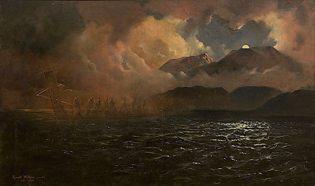
KENNETT WATKINS (1847-1933), Mount Tarawera (1, 111m - 3,645ft), New Zealand (North Island),  In  "The Phantom Canoe - A Legend of Lake Tarawera  ", oil on canvas, Auckland Art Gallery


KENNETT WATKINS (1847-1933)
Mount Tarawera (1, 111m - 3,645ft)
New Zealand (North Island)

In The Phantom Canoe - A Legend of Lake Tarawera , oil on canvas Auckland Art Gallery


The Legend
One legend surrounding the 1886 eruption  of Mount Tarawera is that of the phantom canoe. Eleven days before the eruption, a boat full of tourists returning from the Terraces saw what appeared to be a war canoe approach their boat, only to disappear in the mist half a mile from them. One of the witnesses was a clergyman, a local Maori man from the Te Arawa iwi. Nobody around the lake owned such a war canoe, and nothing like it had been seen on the lake for many years. It is possible that the rise and fall of the lake level caused by pre eruption fissures had freed a burial waka (canoe) from its resting place. Traditionally dead chiefs were tied in an upright position. A number of letters have been published from the tourists who experienced the event.
Though skeptics maintained that it was a freak reflection seen on the mist, tribal elders at Te Wairoa claimed that it was a waka wairua (spirit canoe) and was a portent of doom. It has been suggested that the waka was actually a freak wave on the water, caused by seismic activity below the lake, but locals believe that a future eruption will be signaled by the reappearance of the canoe.

 
The mountain  and the lake
Mount Tarawera (1, 111m - 3,645ft) is the volcano responsible for one of New Zealand's largest historic eruptions. Located 24 kilometres southeast of Rotorua in the North Island, it consists of a series of rhyolitic lava domes that were fissured down the middle by an explosive basaltic eruption in 1886, which killed an estimated 120 people. These fissures run for about 17 kilometres northeast-southwest.
The volcano's component domes include Ruawahia Dome, Tarawera Dome and Wahanga Dome. It is surrounded by several lakes, most of which were created or drastically altered by the 1886 eruption. These lakes include Lakes Tarawera, Rotomahana, Rerewhakaaitu, Okataina, Okareka, Tikitapu (Blue Lake) and Rotokakahi (Green Lake). The Tarawera River runs northeastwards across the northern flank of the mountain from Lake Tarawera.
Main eruptions
- 1315 : Mount Tarawera erupted for the fist time on modern history. The ash thrown from this event may have affected temperatures around the globe and precipitated the Great Famine of 1315–17 in Europe.
- 1886 : Shortly after midnight on the morning of 10 June 1886, a series of more than 30 increasingly strong earthquakes were felt in the Rotorua area and an unusual sheet lightning display was observed from the direction of Tarawera. At around 2:00 am a larger earthquake was felt and followed by the sound of an explosion. By 2:30 am Mount Tarawera's three peaks had erupted, blasting three distinct columns of smoke and ash thousands of metres into the sky (see painting above). At around 3.30 am, the largest phase of the eruption commenced; vents at Rotomahana produced a pyroclastic surge that destroyed several villages within a 6 kilometre radius, and the Pink and White Terraces appeared to be obliterated.
The eruption was heard clearly as far away as Blenheim and the effects of the ash in the air were observed as far south as Christchurch, over 800 km away. In Auckland the sound of the eruption and the flashing sky was thought by some to be an attack by Russian warships.
Although the official contemporary death toll was 153, exhaustive research by physicist Ron Keam only identified 108 people killed by the eruption. Much of the discrepancy was due to misspelled names and other duplications. Allowing for some unnamed and unknown victims, he estimated that the true death toll was 120 at most. Some people claim that many more people died.
The eruption also buried many Māori villages, including Te Wairoa which has now become a tourist attraction (Buried Village of Te Wairoa) and the world-famous Pink and White Terraces were lost. A small portion of the Pink Terraces was rediscovered under Lake Rotomahana 125 years later. Approximately 2 cubic kilometres of tephra was erupted, more than Mount St. Helens ejected in 1980. Many of the lakes surrounding the mountain had their shapes and areas dramatically altered, especially the eventual enlargement of Lake Rotomahana, the largest crater involved in the eruption, as it re-filled with water. 

The painter
Kennett Watkins was born in India in 1847, the son of Major John Watkins and Martha Jane Simons; he was Christened on 21 July 1847 in Ootacamund, Madras, India. His father died some time before 1861. In the UK Census of 1861 he was recorded in the household of his widowed grandmother Sarah Simons at 59 Marine Parade, Brighton, Sussex, England. Aged 13 and a scholar. Also in the household was his widowed mother Martha, his three siblings Lydia, Edward and John, 23 year old cousin Lieut. William Ker and two servants. He was educated in England and, as an artist, in France and Switzerland.
Kennett Watkins migrated from England to New Zealand. He emigrated from England to New Zealand in 1873, where he married Clara Eliza Alice Davis in 1876.
He was a photographer, painter of lndscapes (oil and waterolors) and teacher in Auckland.
He passed away in 1933 at age 86 and was buried in the Mercury Bay Cemetery in Thames-Coromandel District, Waikato, New Zealand.
The earliest auction registered for Kenneth Watkins pianitngs is in1992 for a toal 57 worksoffered for sale of which 29 ( 51%) weresold. The highest price recorded wis $ 136,450 for Maro family Canoeing on the Waokato River.

Tuesday, December 8, 2020

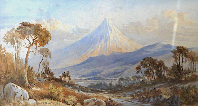
TARANAKI / MOUNT EGMONT PAINTED BY LAURENCE WILLIAM WILSON

https://wanderingvertexes.blogspot.com/2020/12/taranaki-mount-egmont-painted-by.html
 
 
LAURENCE WILLIAM WILSON (1851-1912)
Taranaki /Mount Egmont (2,518 m - 8,261 ft)
New Zealand (Northen Island)

The mountain
Taranaki or Mount Egmont (2,518 m - 8,261 ft) is an active but quiescent stratovolcano in the Taranaki region on the west coast of New Zealand's North Island. Although the mountain is more commonly referred to as Taranaki, it has two official names under the alternative names policy of the New Zealand Geographic Board. The mountain is one of the most symmetrical volcanic cones in the world. There is a secondary cone, Fanthams Peak or Panitahi in Māori (1,966 m - 6,450 ft), on the south side. Because of its resemblance to Mount Fuji, Taranaki provided the backdrop for the movie The Last Samurai.
For many centuries the mountain was called Taranaki by Māori. The Māori word tara means mountain peak, and naki is thought to come from ngaki, meaning "shining", a reference to the snow-clad winter nature of the upper slopes. It was also named Pukehaupapa and Pukeonaki by Iwi who live in the region in ancient times.
According to Māori mythology, Taranaki once resided in the middle of the North Island, with all the other New Zealand volcanoes. The beautiful Pihanga was coveted by all the mountains, and a great battle broke out between them. Tongariro eventually won the day, inflicted great wounds on the side of Taranaki, and causing him to flee. Taranaki headed westwards, following Te Toka a Rahotu and forming the deep gorges of the Whanganui River, paused for a while, creating the depression that formed the Te Ngaere swamp, then heading north. Further progress was blocked by the Pouakai ranges, and as the sun came up Taranaki became petrified in his current location. When Taranaki conceals himself with rainclouds, he is said to be crying for his lost love, and during spectacular sunsets, he is said to be displaying himself to her. In turn, Tongariro's eruptions are said to be a warning to Taranaki not to return.
Captain Cook named it Mount Egmont on 11 January 1770 after John Perceval, 2nd Earl of Egmont, a former First Lord of the Admiralty who had supported the concept of an oceanic search for Terra Australis Incognita. Cook described it as "of a prodigious height and its top cover'd with everlasting snow" surrounded by a "flat country ... which afforded a very good aspect, being clothed with wood and verdure".
When Marc-Joseph Marion du Fresne made landfall off Taranaki on 25 March 1772 he named the mountain Pic Mascarin. He was unaware of Cook's earlier visit. It appeared as Mount Egmont on maps until 29 May 1986, when the Minister of Lands ruled that "Mount Taranaki" would be an alternative and equal official name. The Egmont name still applies to the national park that surrounds the peak and geologists still refer to the peak as the Egmont Volcano.
Taranaki is geologically young, having commenced activity approximately 135,000 years ago. The most recent volcanic activity was the production of a lava dome in the crater and its collapse down the side of the mountain in the 1850s or 1860s. Between 1755 and 1800, an eruption sent a pyroclastic flow down the mountain's northeast flanks, and a moderate ash eruption occurred about 1755, of the size of Ruapehu's activity in 1995/1996. The last major eruption occurred around 1655. Recent research has shown that over the last 9,000 years minor eruptions have occurred roughly every 90 years on average, with major eruptions every 500 years.

The painter
Laurence William Wilson emigrated to Auckland in 1877 and then travelled extensively to settle in Dunedin in 1884. He painted in both oils and watercolours, became a painting companion of George O'Brien and a teacher. One of his pupils was the Dunedin artist Alfred O'Keefe. In 1895, LW Wilson together with Grace Joel, Alfred O'Keefe, Jane Wimperis and Girolami Nerli formed the Easel Club , a breakaway from the Dunedin Establishment, which offered a programme of special classes and the introduction of a professional lady model for life drawing. In 1904 LW Wilson left Dunedin for Melbourne where he spent 5 months on a commissioned painting of the city before he set out for England, eventually returning to New Zealand via India and Africa. He exhibited with the Canterbury Society of Arts in 1882 and the Otago Art Society between 1994 and 1904. His work was included in the NZ and South Seas Exhibition Dunedin 1889-90 and at the St Louis Exposition in 1904. LW Wilson is represented in the collections of all the major public galleries in New Zealand.

___________________________________________

2020 - Wandering Vertexes...
by Francis Rousseau

Saturday, November 28, 2020

WICK MOUNTAINS PAINTED BY LAURENCE WILLIAM WILSON

 https://wanderingvertexes.blogspot.com/2020/11/wick-mountains-painted-by-laurence.html

LAURENCE WILLIAM  WILSON  (1851-1912),
Wick Mountains (993 m - 3,259 ft)
New Zealand

In Wick Mountains upper Arthur River, watercolor,  TePapa Tongarewa Museum of New Zealand


The mountains
The Wick Mountains lie between the Arthur, Cleddau, and Clinton Valleys. This includes the peaks on the west of the Cleddau Valley, from Mt Moir to Sheerdown Peak. That is where they are provisionally placed on this site. The peaks near Homer Saddle – Mt Moir, Moir’s Mate, and the Mateʻs Little Brother – contain a wealth of classic rock routes on amazing diorite. The close proximity of this region to the road makes the routes accessible as day climbs from Homer Hut. Many routes lie on north to west faces, receiving their first rays of sun in the late morning.

The painter
Laurence William Wilson emigrated to Auckland in 1877 and then travelled extensively to settle in Dunedin in 1884. He painted in both oils and watercolours, became a painting companion of George O'Brien and a teacher. One of his pupils was the Dunedin artist Alfred O'Keefe. In 1895, LW Wilson together with Grace Joel, Alfred O'Keefe, Jane Wimperis and Girolami Nerli formed the Easel Club , a breakaway from the Dunedin Establishment, which offered a programme of special classes and the introduction of a professional lady model for life drawing. In 1904 LW Wilson left Dunedin for Melbourne where he spent 5 months on a commissioned painting of the city before he set out for England, eventually returning to New Zealand via India and Africa. He exhibited with the Canterbury Society of Arts in 1882 and the Otago Art Society between 1994 and 1904. His work was included in the NZ and South Seas Exhibition Dunedin 1889-90 and at the St Louis Exposition in 1904. LW Wilson is represented in the collections of all the major public galleries in New Zealand.

___________________________________________

2020 - Wandering Vertexes...
by Francis Rousseau

Wednesday, September 2, 2020

MITRE PEAK / RAHOTU PAINTED BY LAURENCE WILLIAM WILSON


LAURENCE WILLIAM  WILSON  (1851-1912)
Mitre Peak/ Rahotu (1,683m - 5,522 ft)
New Zealand 

In Mitre Peak, Milford Sound, oil on canvas,  Christchurch Art Gallery, New Zealand

The mountain
Mitre Peak/ Rahotu (1,683m - 5,522 ft) is an iconic mountain in the South Island of New Zealand, located on the shore of Milford Sound. It is one of the most photographed peaks in the country. The distinctive shape of the peak in southern New Zealand gives the mountain its name, after the mitre headwear of Christian bishops. It was named by Captain John Lort Stokes of the HMS Acheron.
Part of the reason for its iconic status is its location. Close to the shore of Milford Sound, in the Fiordland National Park in the southwestern South Island, it is a stunning sight. The mountain rises near vertically from the water of Milford Sound, which technically is a fjord.
The peak is actually a closely grouped set of five peaks, with Mitre Peak not even the tallest one, however from most easily accessible viewpoints, Mitre Peak appears as a single point.
Milford Sound is part of Te Wahipounamu, a World Heritage Site as declared by UNESCO.
The only road access to Milford Sound is via State Highway 94, in itself one of the most scenic roads in New Zealand

The painter
Laurence William Wilson emigrated to Auckland in 1877 and then travelled extensively to settle in Dunedin in 1884. He painted in both oils and watercolours, became a painting companion of George O'Brien and a teacher. One of his pupils was the Dunedin artist Alfred O'Keefe. In 1895, LW Wilson together with Grace Joel, Alfred O'Keefe, Jane Wimperis and Girolami Nerli formed the Easel Club , a breakaway from the Dunedin Establishment, which offered a programme of special classes and the introduction of a professional lady model for life drawing. In 1904 LW Wilson left Dunedin for Melbourne where he spent 5 months on a commissioned painting of the city before he set out for England, eventually returning to New Zealand via India and Africa. He exhibited with the Canterbury Society of Arts in 1882 and the Otago Art Society between 1994 and 1904. His work was included in the NZ and South Seas Exhibition Dunedin 1889-90 and at the St Louis Exposition in 1904. LW Wilson is represented in the collections of all the major public galleries in New Zealand.

___________________________________________

2020 - Wandering Vertexes...
by Francis Rousseau


Monday, July 20, 2020

MOUNT EARNSLAW / PIKIRAKATAHI BY LAURENCE WILLIAM WILSON


LAURENCE WILLIAM  WILSON  (1851-1912),
Mount Earnslaw / Pikirakatahi  (2,819m -9,249 ft)
New Zealand 

In  Mount Earnslaw, 1887,   oil on canvas., 84x120cm

The mountain 
Mount Earnslaw, (2,819m -9,249 ft) also named Pikirakatahi by Māori is located on New Zealand's South Island. It is named after Earnslaw (formerly Herneslawe) village in the parish of Eccles, Berwickshire, hometown of the surveyor John Turnbull Thomson's father.
Mount Earnslaw is within Mount Aspiring National Park at the southern end of the Forbes Range of New Zealand's Southern Alps. It is located 25 kilometres north of the settlement of Glenorchy, which lies at the northern end of Lake Wakatipu.

The painter
Laurence William Wilson emigrated to Auckland in 1877 and then travelled extensively to settle in Dunedin in 1884. He painted in both oils and watercolours, became a painting companion of George O'Brien and a teacher. One of his pupils was the Dunedin artist Alfred O'Keefe. In 1895, LW Wilson together with Grace Joel, Alfred O'Keefe, Jane Wimperis and Girolami Nerli formed the Easel Club , a breakaway from the Dunedin Establishment, which offered a programme of special classes and the introduction of a professional lady model for life drawing. In 1904 LW Wilson left Dunedin for Melbourne where he spent 5 months on a commissioned painting of the city before he set out for England, eventually returning to New Zealand via India and Africa. He exhibited with the Canterbury Society of Arts in 1882 and the Otago Art Society between 1994 and 1904. His work was included in the NZ and South Seas Exhibition Dunedin 1889-90 and at the St Louis Exposition in 1904. LW Wilson is represented in the collections of all the major public galleries in New Zealand.

___________________________________________

2020 - Wandering Vertexes...
by Francis Rousseau


Sunday, May 3, 2020

TARANAKI / MOUNT EGMONT( 2) BY CHARLES BLOMFIELD

http://wanderingvertexes.blogspot.com 
CHARLES BLOMFIELD (1848-1926)
Taranaki /Mount Egmont (2,518 m - 8,261 ft)
New Zealand (North Island)

In Mont Egmont, 1880, oil on canvas, Museum of New Zealand  /Te Papa Tongarewa

The mountain
Taranaki or Mount Egmont (2,518 m - 8,261 ft) is an active but quiescent stratovolcano in the Taranaki region on the west coast of New Zealand's North Island. Although the mountain is more commonly referred to as Taranaki, it has two official names under the alternative names policy of the New Zealand Geographic Board. The mountain is one of the most symmetrical volcanic cones in the world. There is a secondary cone, Fanthams Peak or Panitahi in Māori (1,966 me - 6,450 ft), on the south side. Because of its resemblance to Mount Fuji, Taranaki provided the backdrop for the movie The Last Samurai.
More about the mountain

The painter
Charles Blomfield was a New Zealand decorator, artist and music teacher born in London, England.
A widow, Blomfield's mother brought her family to New Zealand in the 1860's intending to settle in Northland as part of a settlement called Albertland. On arrival in Auckland they decided not to proceed on Northland to become farmers but to pursue urban trades in Auckland. The family remained in Auckland after that and many of the descendants of the various children still reside in the Auckland area.
More about the painter 

_________________________________________

2020 - Wandering Vertexes...
by Francis Rousseau

Monday, January 20, 2020

TARANAKI / MOUNT EGMONT BY CHARLES DECIMUS BARRAUD


CHARLES DECIMUS BARRAUD (1822-1897)
Mount Taranaki or Mount Egmont  (2,518 m - 8,261 ft) 
New Zealand (North Island)

In Mount Egmont Taranaki,  watercolour, 1870, Alexander Turnbull Library, New Zealand

The mountain
Taranaki or Mount Egmont (2,518 m - 8,261 ft) is an active but quiescent stratovolcano in the Taranaki region on the west coast of New Zealand's North Island. Although the mountain is more commonly referred to as Taranaki, it has two official names under the alternative names policy of the New Zealand Geographic Board. The mountain is one of the most symmetrical volcanic cones in the world. There is a secondary cone, Fanthams Peak or Panitahi in Māori (1,966 me - 6,450 ft), on the south side.
 For many centuries the mountain was called Taranaki by Māori. The Māori word tara means mountain peak, and naki is thought to come from ngaki, meaning "shining", a reference to the snow-clad winter nature of the upper slopes. It was also named Pukehaupapa and Pukeonaki by Iwi who live in the region in ancient times.
According to Māori mythology, Taranaki once resided in the middle of the North Island, with all the other New Zealand volcanoes. The beautiful Pihanga was coveted by all the mountains, and a great battle broke out between them. Tongariro eventually won the day, inflicted great wounds on the side of Taranaki, and causing him to flee. Taranaki headed westwards, following Te Toka a Rahotu and forming the deep gorges of the Whanganui River, paused for a while, creating the depression that formed the Te Ngaere swamp, then heading north. Further progress was blocked by the Pouakai ranges, and as the sun came up Taranaki became petrified in his current location. When Taranaki conceals himself with rainclouds, he is said to be crying for his lost love, and during spectacular sunsets, he is said to be displaying himself to her. In turn, Tongariro's eruptions are said to be a warning to Taranaki not to return....

The artist
Charles Decimus Barraud was born in Camberwell, London, England. he wanted to become a doctor, but his father, a clerk in the Custom House,  died when Charles was only 11 years old and his family could not afford the expensive training. He had to content himself with qualifying as a chemist and druggist.
Long Biography 

__________________________________

2020 - Wandering Vertexes...
by Francis Rousseau


Sunday, January 19, 2020

MOUNT TARAWERA / PINK TERRACES PHOTOGRAPHED BY CHARLES SPENCER


CHARLES SPENCER (1854-1933)
Mount Tarawera / Pink and White Terraces  (1, 111m - 3,645ft) 
 New Zealand

 In Pink Terraces- c.1900, black and white phototgraphs hand colored, 
Museum of New Zealand / Te Papa Tongarewa


The volcano and the terraces
On 10 June 1886, Mount Tarawera  (1, 111m - 3,645ft) erupted. The eruption spread from west of Wahanga dome, 5 kilometres (3.1 mi) to the north, down to Lake Rotomahana. The volcano belched out hot mud, red hot boulders, and immense clouds of black ash from a 17 kilometres (11 mi) rift that crossed the mountain, passed through the lake, and extended beyond into the Waimangu valley.
After the eruption, a crater over 100 metres (330 ft) in depth encompassed the former site of the terraces.  After some years this filled with water to form a new Lake Rotomahana, 30–40 metres (98–131 ft) higher, ten times larger and deeper than the old lake.  This  explosive basaltic eruption  killed an estimated 120 people.
Alfred Patchet Warbrick, a boat builder at Te Wairoa, witnessed the eruption of Mount Tarawera from Maunga Makatiti to the north of Lake Tarawera. Warbrick soon had whaleboats on Lake Tarawera investigating the new landscape; he in time became the chief guide to the post-eruption attractions. Warbrick never accepted that the Pink and White Terraces had been destroyed

The photographer
When Tarawera erupted only a few weeks later, Geological Survey director James Hector and assistant geologist James Park disembarked at Tauranga on 12 June, en route to the Rotorua lakes district to report on the disturbance. He immediately engaged Charles Spencer who was already a famous photograph in new Zealand, to accompany the party and record the effects of the eruption.
By the time Spencer returned to Tauranga a week later he had accumulated an initial set of plates which he developed and printed. He then returned to Te Wairoa on 8 July and took several more views during a brief spell of decent weather. At the end of the month he made a third visit, accompanying Percy Smith’s surveying party for almost a week, and taking a number of views between the Ruawahia Dome on Tarawera and the craters to the south-west near Rotomahana.
Although no definitive lists exist, it is likely that Spencer produced several dozen views of the Rotorua hot lakes district before and after the eruption, and as a result his are some of the better known images, in collections throughout the world.

__________________________________

2020 - Wandering Vertexes...
by Francis Rousseau


Thursday, December 12, 2019

MITRE PEAK / RAHOTU BY JOHN HOYTE


JOHN  HOYTE (1835-1913)
Mitre Peak / Rahotu (1,683m - 5,522 ft) 
New Zealand (South Island)


In Milford sound, series of watercolour, 1870

The mountain
Mitre Peak/ Rahotu (1,683m - 5,522 ft) is an iconic mountain in the South Island of New Zealand, located on the shore of Milford Sound. It is one of the most photographed peaks in the country. The distinctive shape of the peak in southern New Zealand gives the mountain its name, after the mitre headwear of Christian bishops. It was named by Captain John Lort Stokes of the HMS Acheron.
Part of the reason for its iconic status is its location. Close to the shore of Milford Sound, in the Fiordland National Park in the southwestern South Island, it is a stunning sight. The mountain rises near vertically from the water of Milford Sound, which technically is a fjord.
The peak is actually a closely grouped set of five peaks, with Mitre Peak not even the tallest one, however from most easily accessible viewpoints, Mitre Peak appears as a single point.
Milford Sound is part of Te Wahipounamu, a World Heritage Site as declared by UNESCO.
The only road access to Milford Sound is via State Highway 94, in itself one of the most scenic roads in New Zealand.

The painter
John Barr Clark Hoyte was born in England, probably in London, the son of Samuel Hoyte, a landowner. His mother's name is not known, nor are any details of his childhood. From 1856 to 1859 he was employed as a planter in Demerara, Guyana, after which he returned to England. On 1860, at Leamington, Warwickshire, he married Rose Esther Elizabeth Parsons, daughter of an iron merchant. Within three months they sailed on the Egmont for Auckland, New Zealand, where they were to live for 16 years. Three daughters were born in Auckland, and the couple may also have had a son. A brother of John Hoyte emigrated to New Zealand, possibly in the 1870s.
Nothing is known of Hoyte's education and artistic training and we are reduced to the obvious deduction that he was heir to the English tradition of topographic draughtsmanship and watercolour painting. Firm drawing underlies his landscapes, making it appropriate to group him with colonial surveyor–architect artists such as Edward Ashworth, Edmund Norman and George O'Brien.
During his years in New Zealand John Hoyte travelled assiduously in search of new scenes to exploit. In January 1866 he exhibited views from Whangarei, Coromandel, Auckland, Waikato, the Wellington region and Nelson, although some of these pictures were not painted from the subject. In the 1870s he travelled each summer, progressively adding the thermal region, Taranaki, Nelson, Christchurch, Arthur's Pass, Banks Peninsula and Otago to his repertoire between 1872 and 1876.
His pictorial exploration of the colony's principal dramatic landscapes was completed when he took a cruise circumnavigating the South Island in early 1877, exploring the coast of Fiordland with particular attention. New Zealand subjects would continue to inspire his production long after he had settled in Australia, where they shared his attention with coastal and mountain views drawn chiefly from the neighbourhood of Sydney.
The success of the art unions of his work shows that the subjects he painted were in harmony with public taste. Despite the exceptional landscapes which appear so frequently in his production – geysers, the Pink and White Terraces, fiords, mountains and lakes – it appears that his preference was for a more gentle, picturesque mode of landscape art rather than the heightened tensions of the sublime. The Otago Guardian in 1876 described 'the aspect of repose which usually characterises Mr Hoyte's illustrations of native landscapes'. A comparison of Fiordland subjects painted by Hoyte and John Gully shows that Hoyte eschewed the manipulation of the viewer's emotions which the latter exploited so regularly. Even in his pastoral subjects Gully could be relied on to introduce an epic element which Hoyte usually avoided. Despite his apparent commercial success, however, Hoyte's standing, like that of George O'Brien, waned in the 1870s: a decade which marked a major shift in New Zealand colonial taste as the Turnerian Romantics such as Gully, J. C. Richmond and W. M. Hodgkins moved into greater prominence. They and their style were to dominate the following decades.

___________________________________________
2019 - Wandering Vertexes...
by Francis Rousseau

Wednesday, October 9, 2019

MT MANAIA BY JOHN BARR CLARK HOYTE


JOHN BARR CLARK HOYTE (1835-1913) 
Mount Manaia (420m- 1,378ft)
New Zealand (North Island)

 In Mount Manaia- Whangarei Head, oil on canvas, 1890  

The mountain 
Mount Manaia   (420m- 1,378ft) is a dominant landmark approximately 30 kilometres southeast of Whangarei city on the Whangarei Heads peninsula.
The summit offers outstanding views of  Bream Bay and the Hauraki Gulf to the south, Whangarei Harbour to the west and the Poor Knights Islands and Northland coast to the north.
Mt Manaia - along with Mt Lion, Bream Head and the Hen and Chicken Islands, are the scattered remnants of a large, 50 kilometer diameter volcano that erupted with force 20 million years ago during the early miocene period. Its jagged outline is similar to that of its neighbours and other volcanic outcrops in Northland that erupted in a similar period.
Today blanketed by native bush, Manaia's jagged peaks and steep bluffs are protected within a Department of Conservation reserve which features a well-maintained 1½ hour track to the summit.

The Painter
John Barr Clark Hoyte was born in England, probably in London, Nothing is known of Hoyte's education and artistic training and we are reduced to the obvious deduction that he was heir to the English tradition of topographic draughtsmanship and watercolour painting. Firm drawing underlies his landscapes, making it appropriate to group him with colonial surveyor–architect artists such as Edward Ashworth, Edmund Norman and George O'Brien.
During his years in New Zealand John Hoyte travelled assiduously in search of new scenes to exploit. His pictorial exploration of the colony's principal dramatic landscapes was completed when he took a cruise circumnavigating the South Island in early 1877, exploring the coast of Fiordland with particular attention. New Zealand subjects would continue to inspire his production long after he had settled in Australia, where they shared his attention with coastal and mountain views drawn chiefly from the neighbourhood of Sydney.
Despite his apparent commercial success, however, Hoyte's standing, like that of George O'Brien, waned in the 1870s: a decade which marked a major shift in New Zealand colonial taste as the Turnerian Romantics such as Gully, J. C. Richmond and W. M. Hodgkins moved into greater prominence. They and their style were to dominate the following decades.
__________________________________________
2019 - Wandering Vertexes...
by Francis Rousseau

Wednesday, September 11, 2019

THE REMARKABLES PAINTED BY DORIS LUSK


DORIS LUSK (1916-1990) 
The Remarkables  (2,319 m - 7,601ft) 
New Zealand (South Island)

 In Late afternoon Lake Wakatipu, New Zealand  oil on canvas, 1958, Te Papa Museum

The mountains 
The Remarkables  (2,319 m - 7,601ft)  are a mountain range and skifield in Otago in the South Island of New Zealand. Located on the southeastern shore of Lake Wakatipu,  renowned for its scenic beauty, the range lives up to its name by rising sharply to create an impressive backdrop for the waters. The range is clearly visible from the nearby town of Queenstown.
The highest point in the range is Single Cone (2,319 m). The adjacent Hector Mountains southeast of the Remarkables culminate in Mount Tūwhakarōria (23,07 m).
There are a number of small lakes on the mountains including Lake Alta which forms part of the Remarkables Skifield.
The mountains were named The Remarkables by Alexander Garvie in 1857-58,  allegedly because they are one of only two mountain ranges in the world which run directly north to south.[ An alternate explanation for the name given by locals is that early Queenstown settlers, upon seeing the mountain range during sunset one evening, named them the Remarkables to describe the sight.

The painter
Doris More Lusk was a New Zealand artist and art teacher, potter, university lecturer.  In 1990 she was posthumously awarded the Governor General Art Award in recognition of her artistic career and contributions. Lusk exhibited mainly with The Group in Christchurch in the 1940s and 1950s.  In the 1950s and 1960s her work was regularly included in the Auckland City Art Gallery's annual surveys of recent New Zealand painting. Lusk exhibited mainly with The Group in Christchurch in the 1940s and 1950s.
 In the 1950s and 1960s her work was regularly included in the Auckland City Art Gallery's annual surveys of recent New Zealand painting.
The first retrospective exhibition of Lusk's work was held at the Dunedin Public Art Gallery in 1966.A second retrospective was held at the Dowse Art Museum in 1973. A major exhibition of her landscape works, Landmarks: The Landscape Paintings of Doris Lusk, was held at the Christchurch Art Gallery in 1996, accompanied by a publication with contributions by Lisa Beaven and Grant Banbury.
To mark the centenary of Lusk's birth in 1916, in 2016 exhibitions were held at the Dunedin Public Art Gallery (Doris Lusk 1916-1990) and Christchurch Art Gallery (Doris Lusk: Practical Visionary).

____________________________________________
2019 - Men Portraits 
Un blog de Francis Rousseau