google.com, pub-0288379932320714, DIRECT, f08c47fec0942fa0 GRAVIR LES MONTAGNES... EN PEINTURE: October 2022

Monday, October 31, 2022

PUERTO DE PAGARES PEINT PAR CARLOS DE HAES


CARLOS DE HAES (1829-1898) Puerto de Pajares (1,378m - 4,520ft) Espagne (Asturias)
 

CARLOS DE HAES (1829-1898)
Puerto de Pajares (1,378m - 4,520ft)
Espagne (Asturias)

La montagne
Puerto de Pajares (1 378 m - 4 520 pieds) est un col de montagne dans les montagnes cantabriques situé à Pajares, en Espagne. C'est la principale voie de communication par chemin de fer et route gratuite entre les Asturies, la province de León et le centre de l'Espagne. Il existe une autoroute privée alternative à péage, L'AP-66.réputée pour son brouillard persistant  pendant les nuits d'été et sa déclivité qui atteint  jusqu'à 17%,.

L'artiste
Le peintre espagnol Carlos Sebastián Pedro Hubert de Haes était connu pour le réalisme de ses paysages et était considéré comme le "premier artiste espagnol contemporain capable de capturer quelque chose de particulièrement espagnole dans son travail". Il a souvent été cité comme l'un des trois grands maîtres espagnols de la peinture de paysage. Dans les années 1850, Haes participa à l'essor de l'école réaliste du paysage.  En 1857, il devint le premier professeur de peinture de paysage en Espagne qui enseigna la peinture sur le sujet, en plein air directement d'après nature. En 1860, il devint académicien à l'Académie royale espagnole.  En 1876, il  se présenta à l'Exposition nationale avec La Canal de Mancorbo en los Picos de Europa ("Le canal de Mancorbo dans les Picos de Europa") acquis plus tard par l'État espagnol pour faire partie des collections du Museo del Prado, en raison de son importance dans l'Histoire de la  peinture espagnole du paysage.

 __________________________________________

2022 - Wandering Vertexes ....
            Errant au-dessus des Sommets Silencieux...
            Un blog de Francis Rousseau


Friday, October 28, 2022

L 'ACROPOLE D'ATHÊNES PEINT PAR FREDERIC EDWIN CHURCH


FREDERIC EDWIN CHURCH (1826-1900) The Acropolis of Athens (156m -512ft) Greece  In Acropolis od Athens,  oil on canvas, The MET
 
FREDERIC EDWIN CHURCH (1826-1900)
L'Acropole d'Athènes (156m -512ft)
Grèce

In Acropolis od Athens,  oil on canvas, The MET


La colline
L'Acropole d'Athènes (156m -512ft) (Ακρόπολη Αθηνών) est situé sur un plateau rocheux calcaire dont le sommet plat mesure environ 270 mètres d'est en ouest et 85 mètres du nord au sud, s'élargissant jusqu'à près de 150 mètres grâce au travaux faits au  Ve siècle avant l'ère chrétienne. Le terme d"acropole" (ἀκρόπολις / akrópolis) vient de l'adjectif ἄκρος (ákros "haut") et du nom πόλις (pólis, "ville, ville"), signifiant ainsi  la "ville haute".
Il est accessible du côté ouest par une pente raide menant aux Propylées. Le plateau peut être aussi atteint par deux failles creusées par l'érosion sur la  face nord . Les faces est et sud  sont aussi inaccessibles. C'est même par le côté est, jugé trop escarpé et donc non surveillé, que les Perses pénétrèrent dans la forteresse en 480 avant l'ère chrétienne.
Le sanctuaire de l'Acropole d'Athènes s'organise autour de la statue de la divinité tutélaire de la ville. Cette statue d'Athéna Polias n'est connue que par quelques textes. Ce devait être un Xoanon, une sorte de poutre en bois d'olivier, presque aniconique.   Elle devait être plutôt debout : une poutre est difficile à asseoir et ressemble plus à un personnage debout qu'assis ; il n'y a pas non plus de mention de trône dans les textes ; enfin, Athéna est le plus souvent représentée debout.
Chaque année, la statue était lavée, ses péplos changés et sa parure (bijoux et accessoires) nettoyée. Ses bijoux étaient des boucles d'oreilles, une bordure sur le cou et cinq colliers. Ses accessoires, tout en or, étaient une chouette, une égide, une gorgone et une phiale. Elle n'avait pas d'armes : elle n'était donc pas la déesse guerrière des statues les plus célèbres par la suite (Athéna Parthénos et Athéna Promachos de Phidias). Ces bijoux et accessoires pourraient dater de la "restructuration" de la statue primitive par Endoios. Il aurait fait de la poutre une corée en y fixant un bras (et une main tenant la phiale)

Le peintre
Frederic Edwin Church  est un peintre américain dont l'œuvre constitue l'expression la plus originale et la plus complète du romantisme dans la peinture américaine. Church a le paysage pour domaine. Élève de Thomas Cole entre 1844 et 1846, il commence par recueillir les formules ambiguës de son maître et sa vision d'un immense paysage dramatisé. Mais, tandis que chez la plupart des peintres de l'école de l'Hudson l'exemple de Cole aboutit à un type de paysage composé, tout de poncifs, Church le renouvelle par une étude passionnément objective de la nature. À partir de 1890 environ, il entreprend de grands voyages à travers le continent américain, accumulant des études sur le motif, où l'action de la lumière est notée avec une précision quasi photographique. Ces études s'apparentent à celles d'Asher B. Durand, par exemple, et, comme lui, Church les utilise pour de grands paysages composés. Mais au lieu d'« idéaliser » l'observation initiale suivant les vieux procédés du paysage classique, il rejoint plutôt la jeune tradition « luministe » américaine, son hyperréalisme de la lumière qui donne la même intensité à tous les détails. Les motifs de prédilection de Church, inspirés par les terribles magnificences de la nature — montagnes, forêts vierges, glaciers, chutes d'eau (Le Niagara, 1857, Cocoran Gallery of Art, Washington ; Le Cœur des Andes, 1859, Metropolitan Museum, New York ; Le Cotopaxi, collection Aston, New York) —, rejoignent le répertoire du grand romantisme européen (Caspar David Friedrich, J.M.W. Turner...) et contiennent le même pouvoir de suggestion, le même symbolisme élémentaire et puissant. À un moment où le romantisme ne s'exprime plus guère dans la peinture européenne que sous une forme dérisoire, l'œuvre de Church constitue une réalisation saisissante du rêve exprimé par Baudelaire, qui, dans le Salon de 1859, regrettait que l'imagination doive fuir le paysage et évoquait avec nostalgie « le paysage romantique et même le paysage romanesque ».

 __________________________________________

2022 - Wandering Vertexes ....
            Errant au-dessus des Sommets Silencieux...
            Un blog de Francis Rousseau

Tuesday, October 25, 2022

LE LEMBERG PEINT PAR ALBERT BIRKLE


ALBERT BIRKLE  (1900-1986) The Lemberg (1,015m -3,330 ft) Germany (Swabian Jura)  In Petersfelsen bei Beuron- Upper Danube Valley, 1922, oil on cardboard, 70cm x 51cm 
 
ALBERT BIRKLE  (1897-1966)
Le Lemberg (1,015m -3,330 ft) 
Allemagne  (Jura Spoiabe) 
 
In Petersfelsen bei Beuron- Upper Danube Valley, 1922, huile sur carton, 70cm x 51cm


La montagne
Le Lemberg  (1,015m -3,330 ft) est la plus haute montagne du Jura souabe. Elle se situe à l'est de Rottweil, dans le district de Tuttlingen près de la commune de Gosheim, dans le Bade-Wurtemberg en Allemagne. A son sommet se dresse une tour de 30 m de haut, culminant au-dessus des arbres environnants, et offrant par beau temps une perspective atteignant les Alpes.
Comme la plupart des montagnes du Jura souabe, le Lemberg est une " butte témoin ",  c'est à dire un vestige d'un massif qui s'est érodé, faisant ressortir les sommets dans un matériau plus dur.
A partir du 8e siècle av. J.-C. au 5e siècle av. J.-C. (à l'époque de Hallstatt), la montagne abritait une colonie celtique. On trouve encore à son sommet les ruines des murs et des tombes d'une ancienne forteresse. À l'est et à l'ouest, le sommet a été aplati. Des traces d'activité celtique peuvent être trouvées dans les montagnes environnantes, comme dans toute la région de Heuberg.
Le nom Lemberg vient de la langue celtique, dans laquelle Lem signifie marécage ou tourbière. Son origine est probablement la rivière Bära, qui prend naissance au pied de la montagne. On pense qu'à l'époque préhistorique, son débit d'eau était plus important, rendant les environs marécageux.
Aujourd'hui, la tour Lemberg  à son sommet est une tour en acier de 34 mètres de haut au sommet de la montagne, construite en 1899.


Le peintre
Albert Birkle est né à Charlottenburg, alors ville indépendante et depuis 1920 partie de Berlin. Son grand-père et son père, Carl Birkle, étaient tous deux peintres, originaires de Souabe. Albert Birkle a été formé comme peintre décorateur dans l'entreprise de son père. De 1918 à 1924, il étudie à la Hochschule für die bildenden Künste/College of Fine Arts, prédécesseur de l'actuelle Universität der Künste Berlin. Birkle a développé un style unique inspiré par l'expressionnisme et la Nouvelle Objectivité/Neue Sachlichkeit. Ses sujets étaient des paysages solitaires et mystiques, des scènes typiques du Berlin des années 20 et 30, telles que des scènes du parc Tiergarten, des scènes de bar, etc., des portraits de personnages et des scènes religieuses. Dans son style de portrait, il était souvent comparé à Otto Dix et George Grosz. En 1927, Birkle a eu son premier one man show à Berlin, qui s'est avéré être un grand succès. il décide de refuser un poste de professeur à l'Académie des Arts de Koenigsberg afin de continuer à travailler de manière indépendante en tant qu'artiste et de se consacrer à des missions dans le domaine de la décoration d'églises, dont il est devenu un spécialiste. Alors que le national-socialisme était en route vers le pouvoir, Birkle s'installa à Salzbourg, en Autriche, en 1932. Néanmoins, il représenta l'Allemagne à la Biennale de Venise jusqu'en 1936. En 1937, son œuvre fut déclarée "entartée", ses œuvres furent supprimées. de collections publiques, et une interdiction de peindre lui a été imposée. En 1946, Birkle a reçu la nationalité autrichienne. Dans l'année d'après-guerre, il gagne sa vie en peignant des fresques religieuses pour diverses églises et en faisant des peintures à l'huile. Au cours de sa dernière année, il est de plus en plus revenu à ses thèmes berlinois des années 20 et 30.
Les premiers travaux d'Albert Birkle étaient associés à Otto Dix et Grosz, ce qui ne semble pas vraiment juste à la lumière de sa propre originalité, car les thèmes sociaux et autres sont régulièrement teintés d'éléments fantaisistes, grotesques et lunatiques dans son wirk. Dans le cas de Birkle, la peinture typique de la Nouvelle Objectivité est plutôt une exception.

 __________________________________________

2022 - Wandering Vertexes ....
            Errant au-dessus des Sommets Silencieux...
            Un blog de Francis Rousseau

Saturday, October 22, 2022

CIRQUE DE BARROSA SKETCHED BY FRANZ SCHRADER


FRANZ SCHRADER (1844-1924), The Cirque de Barrosa (1,745m - 5,725 ft) France- Spain border (Pyrénées)  In "Le Cirque de Barrosa", watercolor


FRANZ SCHRADER (1844-1924),
The Cirque de Barrosa (1,745m - 5,725 ft)
France- Spain border (Pyrénées)

In "Le Cirque de Barrosa", watercolor


The painter
Jean-Daniel-François Schrader, better known as Franz Schrader, was a French mountaineer, geographer, cartographer and landscape painter. He made an important contribution to the mapping of the Pyrenees and was highly considered among the pyreneists.
He is the son of Prussian Ferdinand Schrader from Magdeburg, who emigrated to Bordeaux, and of Marie-Louise Ducos, cousin of geographers Élisée and Onésime Reclus. He shows a talent for drawing from an early age. In 1866, while staying with his friend Léonce Lourde-Rocheblave in Pau, he has a sort of revelation at the "spectacle grandiose de la barrière montagneuse des Pyrenées ".
His vocation strengthens when reading stories by Ramond de Carbonnières (1755-1827) (Les Voyages au Mont-Perdu) and by Henry Russell (1834-1909) (Les Grandes Ascensions des Pyrénées, guide d'une mer à l'autre).
While devoting the main part of his leisure to long hikes in the mountains, during which he gathers thousands of observations for his topographical records, he still finds time to paint numerous panoramas of the Pyrenees as well as the Alps which he also studies, and to acquire a solid formation in topography.
To facilitate topographical work in rugged terrain, he develops the orograph in 1873. His first great cartographic work, in 1874, is the map of the massif of Gavarnie-Mont-Perdu at a scale of 1:40 000, for which he collects the measurements with the participation of Lourde-Rocheblave from nearby Pau. That map triggers such a sensation that it is included in the annual Mémoires of the Société des Sciences Physiques et Naturelles de Bordeaux with an explanatory text the following year. The Club alpin français directory follows with the publication of an enthusiastic review, describing Schrader as qualified for "first rank topographer in a glorious master stroke". In 1876 he takes part in the creation of the Bordeaux section of the Club Alpin Français, becoming its first president.
In 1877 he travels to Paris with a recommendation from his cousins Élisée and Onésime Reclus. There, having met Émile Templier, nephew and collaborator of Louis Hachette, and Adolphe Joanne, president of the Parisian section of the Club Alpin Français, he is employed as a geographer by Librairie Hachette and is now able to practice his passion in the scope of his profession. He also gives geography lessons at the School of Anthropology and also becomes editor of the French Alpine Club directory
In 1927, three years after his death, his remains are transferred to a tomb on a slope of the Circus of Gavarnie (French Pyrenees). 

The mountain
The Cirque de Barrosa (1745m - (Circo de Barrosa in Spanish) is a glacial cirque located in the center of the Pyrenees chain, in Spain, in the comarca of Sobrarbe (province of Huesca, autonomous community of Aragon). Part of its ridge line forms the border with France.
It is a beautiful mountain circus, attractive for mountaineers, but it is distinguished by its geological structure in two floors, the upper floor being part of an overlap, and by the remains of an old mule track which crosses it from side to side. However, these two singularities are intimately linked since this path has been laid out on a natural cornice which runs, in the cliffs, at the limit between the two floors, which gives its route a great interest from a geological point of view.
In addition, the Cirque de Barrosa provides the opportunity to take an interest in several stories: those of mining in the region of the cirque, to which this path is linked; that of human relations between France and the Bielsa valley, via this path or neighboring passes; that of an episode of the Spanish Civil War, of which the Bielsa Valley was the scene; and that of Pyreneism, whose pioneers discovered the circus at the end of the 19th century.

_______________________________

2022 - Wandering Vertexes...
by Francis Rousseau

Wednesday, October 19, 2022

ALBORZ RANGE PHOTOGRAPHED BY FRÉDÉRIC GADMER IN 1927


FRÉDÉRIC GADMER (1878-1954) Alborz range (5,610.0 m -18,405.5 ft) Iran  In  "Vallée dans La chaine de l'Elbourz vue de Téhéran ", Iran, Autochrome Lumiere, 1927,   Courtesy Collection Albert Kahn, Paris.


FRÉDÉRIC GADMER (1878-1954)
Alborz range (5,610.0 m -18,405.5 ft)
Iran

In  "Vallée dans La chaine de l'Elbourz vue de Téhéran ", Iran, Autochrome Lumiere, 1927, 

Courtesy Collection Albert Kahn, Paris.


The photographer
Frédéric Georges Gadmer was born in 1878 in France into a Protestant family; his father, Leon, son of Swiss émigré, was confectioner. Before World War II, he follows his family in Paris and works as a photographer for the house Vitry, located Quai de la Rapée. As an heliogravure company, it performs work for the sciences and the arts, travel and education. In 1898 Gadmer completed his military service as a secretary to the staff then recalled in 1914 at the time of mobilization. In 1915, he joined the newly created "Photographic Section of the Army" and carried pictures on the front, in the Dardanelles, with General Gouraud, then in Cameroon. In 1919, at age 41, he was hired as a photographer by Albert Khan for his project called "Archives of the Planet". He finds there his comrades of "the film and photographic section of the army" Paul Castelnau and Fernand Cuville. Soon as he arrived, he made reports in Syria, Lebanon, Turkey and Palestine. It was the first to make a color portrait of Mustafa Kemal, leader of the Young Turks. In 1921, he returned to the Levant with Jean Brunhes, the scientific director of the Archives of the Planet. The same year, he attended General Gouraud, appointed High Commissioner in Syria. Operator and prolific photographer, specializing in distant lands and landscapes, it covers Iraq, Persia, Afghanistan, Algeria and Tunisia. In 1930, he accompanied Father Francis Aupiais in Dahomey. He also works in Europe. In 1931, at the request of Marechal Lyautey, he photographies the Colonial Exhibition. It is one of the last person to leave the "Archives of the Planet" threatened by the Albert Kahn's bankruptcy in 1932. He then worked at the famous french newspaper L'Illustration and carries postcards for Yvon. He died in Paris, unmarried, in 1954.


The mountains
The Alborz ( Persian: البرز) range, also spelled as Alburz, Elburz or Elborz, is a mountain range in northern Iran that stretches from the border of Azerbaijan along the western and entire southern coast of the Caspian Sea and finally runs northeast and merges into the smaller Aladagh Mountains and borders in the northeast on the parallel mountain ridge Kopet Dag in the northern parts of Khorasan. All these mountains are part of the much larger Alpide belt. This mountain range is divided into the Western, Central, and Eastern Alborz Mountains. The Western Alborz Range (usually called the Talysh) runs south-southeastward almost along the western coast of the Caspian Sea. The Central Alborz (the Alborz Mountains in the strictest sense) runs from west to east along the entire southern coast of the Caspian Sea, while the Eastern Alborz Range runs in a northeasterly direction, toward the northern parts of the Khorasan region, southeast of the Caspian Sea. Mount Damavand, the highest mountain in Iran measuring 5,610.0 m (18,405.5 ft), is located in the Central Alborz Mountains.


About the "Autochrome Lumière" Photos
The autochrome is a photographic reproduction of process colors patented December 17, 1903 by Auguste and Louis Lumière french brothers. This is the first industrial technique of photography colors, it produces positive images on glass plates. It was used between 1907 and 1932 approximately an particularly in many pictures of the World War I. A important number of photographs of mountains and landscapes around the world was made with this technique, particularly in the for the Project "The archives of the planet" by Albert Kahn.
_______________________________

2022 - Wandering Vertexes...
by Francis Rousseau

Sunday, October 16, 2022

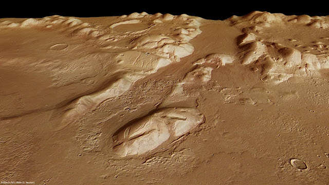
PHLEGRA MONTES PHOTOGRAPHED BY ESA MARS EXPRESS MISSION


MARS EXPRESS MISSION ( 2004-2022) Phlegra Montes (1,4km - 870 mi) Mars (Solar system)

ESA MARS EXPRESS MISSION ( 2004-2022)
Phlegra Montes (1,4km - 870 mi)
Mars (Solar system)


About that image
The High-Resolution Stereo Camera on ESA’s Mars Express collected the data for these images on 1 June 2011 during orbit 9465. This perspective view has been calculated from the Digital Terrain Model derived from the stereo channels.
Courtesey ESA/DLR/FU Berlin (G. Neukum),CC BY-SA 3.0 IGO


The mountains
The Phlegra Montes are a system of eroded Hesperian–Noachian-aged massifs and knobby terrain in the mid-latitudes of the northern lowlands of Mars, extending northwards from the Elysium Rise towards Vastitas Borealis for nearly 1,400 km (870 mi). The mountain ranges separate the large plains provinces of Utopia Planitia (west) and Amazonis Planitia (east), and were named in the 1970s after a classical albedo feature. The massif terrains are flanked by numerous parallel wrinkle ridges known as the Phlegra Dorsa. The mountain ranges were first mapped against imagery taken during NASA's Viking program in the 1970s, and the area is thought to have been uplifted due to regional-scale compressive stresses caused by the contemporary formations of the Elysium and Tharsis volcanic provinces. Recent research has unveiled the presence of extensive thrust faulting bounding the massif terrains. Since the 2010s, researchers have proposed the presence of a significant late Amazonian glaciation event along the Martian northern mid-latitudes, citing the presence of lineated valley fills, lobate debris aprons, and concentric crater fills. The presence of ring mold craters imply that significant stores of water ice may continue to persist in these terrains. Features interpreted as eskers have been observed in the southern Phlegra Montes. However, whether this glaciation was localized or of regional scale remains subject to debate in the scientific community.

About the mission
Mars Express is a space exploration mission being conducted by the European Space Agency (ESA). The Mars Express mission is exploring the planet Mars, and is the first planetary mission attempted by the agency. "Express" originally referred to the speed and efficiency with which the spacecraft was designed and built.However, "Express" also describes the spacecraft's relatively short interplanetary voyage, a result of being launched when the orbits of Earth and Mars brought them closer than they had been in about 60,000 years. Mars Express consists of two parts, the Mars Express Orbiter and Beagle 2, a lander designed to perform exobiology and geochemistry research. Although the lander failed to fully deploy after it landed on the Martian surface, the orbiter has been successfully performing scientific measurements since early 2004, namely, high-resolution imaging and mineralogical mapping of the surface, radar sounding of the subsurface structure down to the permafrost, precise determination of the atmospheric circulation and composition, and study of the interaction of the atmosphere with the interplanetary medium. Due to the valuable science return and the highly flexible mission profile, Mars Express has been granted several mission extensions. The latest was approved on 1 October 2020 and runs until 31 December 2022. Some of the instruments on the orbiter, including the camera systems and some spectrometers, reuse designs from the failed launch of the Russian Mars 96 mission in 1996 (European countries had provided much of the instrumentation and financing for that unsuccessful mission). The design of Mars Express is based on ESA's Rosetta mission, on which a considerable sum was spent on development. The same design was also used for ESA's Venus Express mission in order to increase reliability and reduce development cost and time. Because of these redesigns and repurposings, the total cost of the project was about $345 million- less than half of comparable U.S. missions. Arriving at Mars in 2003, 18 years, 9 months and 10 days ago (and counting), it is the second longest surviving, continually active spacecraft in orbit around a planet other than Earth, behind only NASA's still active 2001 Mars Odyssey.

______________________________
2022- Wandering Vertexes
A blog by Francis Rousseau

Thursday, October 13, 2022

MOUNT ZEIL / URLATHERRKE PAINTED BY ALBERT NAMATJIRA


ALBERT NAMATJIRA (1902-1959) Mount Zeil ot Urlatherrke (1,531 m - 5,023 ft) Australia  In "Glen Helen", watercolor, 1930


ALBERT NAMATJIRA (1902-1959)
Mount Zeil ot Urlatherrke (1,531 m - 5,023 ft)
Australia

In "Glen Helen", watercolor, 1930


The mountain 
Mount Zeil (1,531m - 5,023ft)  Urlatherrke  in aboriginal naming,  is a mountain situated in the western MacDonnell Ranges in Australia's Northern Territory. It is the highest peak in the Northern Territory, and the highest peak on the Australian mainland west of the Great Dividing Range. The others peaks of MacDonell Ranges are:  Mount Liebig (1,524m - 5,000 ft), Mount Edward  (1,423m - 4,669 ft), Mount Giles (1,389m - 4,557 ft) and Mount Sonder (1,380m - 4,530 ft). 
It is believed that Mount Zeil was named during or following Ernest Giles' 1872 expedition, probably after Count Zeil, who had recently distinguished himself with geographic explorations in Spitzbergen; a footnote in Giles' published journal implies that the naming was instigated by his benefactor, Baron Ferdinand von Mueller.
The MacDonnell Ranges, a mountain range and an interim Australian bioregion, is located in the Northern Territory, comprising 3,929,444 hectares (9,709,870 acres). The range is a 644 km (400 mi) long series of mountains located in the centre of Australia, and consist of parallel ridges running to the east and west of Alice Springs. The mountain range contains many spectacular gaps and gorges as well as areas of aboriginal significance. The ranges were named after Sir Richard MacDonnell (the Governor of South Australia at the time) by John McDouall Stuart, whose 1860 expedition reached them in April of that year. The Horn Expedition investigated the ranges as part of the scientific expedition into central Australia. Other explorers of the range included David Lindsay and John Ross.The headwaters of the Todd, Finke and Sandover rivers form in the MacDonnell Ranges. The range is crossed by the Australian Overland Telegraph Line and the Stuart Highway. Part of the Central Ranges xeric scrub ecoregion of dry scrubby grassland  the ranges are home to a large number of endemic species including the Centralian Tree Frog. This is mostly due to the micro climates that are found around the cold rock pools.
The MacDonnell Ranges were often depicted in the paintings of Albert Namatjira.
 
The Painter
Albert Namatjira  born Elea Namatjira, was a Western Arrernte-speaking Aboriginal artist from the MacDonnell Ranges in Central Australia. As a pioneer of contemporary Indigenous Australian art, he was the most famous Indigenous Australian of his generation.
Born and raised at the Hermannsburg Lutheran Mission outside Alice Springs, Namatjira showed interest in art from an early age, but it was not until 1934 (aged 32), under the tutelage of Rex Battarbee, that he began to paint seriously. Namatjira's richly detailed, Western art-influenced watercolours of the outback departed significantly from the abstract designs and symbols of traditional Aboriginal art, and inspired the Hermannsburg School of painting. He became a household name in Australia—indeed, reproductions of his works hung in many homes throughout the nation—and he was publicly regarded as a model Aborigine who had succeeded in mainstream society.
Although not the first Aboriginal artist to work in a European style, Albert Namatjira is certainly the most famous. Ghost gums with luminous white trunks, palm-filled gorges and red mountain ranges turning purple at dusk are the hallmarks of the Hermannsburg school. Hermannsburg Mission was established by Lutheran missionaries in 1877 on the banks of the Finke River, west of Mparntwe (Alice Springs). Namatjira learnt watercolour technique from the artist, Rex Battarbee.
 
______________________________
2022- Wandering Vertexes
Un blog de Francis Rousseau

Monday, October 10, 2022

THE FIZTROY (?) PAINTED BY RHOD WULFARS


RHOD WULFARS (bn. 1979), The Fitz Roy / Cerro Chalten (3,405 m- 11, 171 ft) Chile - Argentina border


RHOD WULFARS (bn. 1979),
The Fitz Roy / Cerro Chalten (3,405 m- 11, 171 ft)
Chile - Argentina border

About this painting
The painter wrote: “It is not a real mountain. Most of my paintings are born from the combination of the imagination and the hours spent looking, walking and smelling them. I call them "Twins" because they are similar to those reliefs of the Argentinian Andean Coridilla called "acarreos", which are long slopes of very popular loose rock that can be easily viewed. very frequently observed. This painting is therefore that of an unknown mountain, dreamt up which sums up several, and which came out of my unconscious one afternoon when the brush gave it life in a mysterious way without my being able to explain it. "
The artist
Rhod Wulfars is a contemporary mountain painter using mainly acrylic technique for his paintings.
He was born in 1979 in Mendoza (Argentina). In his website he wrote: "I have spent my whole life by the mountains. On day I started to paint them". Using, in the manner of Nicolas de Staël, a style always beetween abstract and figurative, his very strong and very moving paintings described perfectly the majesty and the spectacular contents of the peaks he paints. Rhod Wulfars makes a surprising use of acrylic medium, in thick paste as one could do with oil paint. He used to named his works only bu numbers, and series letters, but sometime he writes the name of the peaks ans makes it more easy to identify. Other works by this artist on his website : rhodwulfars.wixsite.com/rhodwulfars/


The mountain
Fitz Roy / Cerro Chalten (3,405m- 11, 171 ft) is a mountain located near El Chaltèn village, in the Southern Patagonian Ice Field in Patagonia, on the border between Argentina and Chile. First climbed in 1952 by French alpinists Lionel Terray and Guido Magnone, " The Fitz Roy " remains among the most technically challenging mountains for mountaineers on Earth. Mount Fitz Roy is the basis for the Patagonia clothing logo following Yvon Chouinard's ascent and subsequent film in 1968.
Argentine explorer Francisco Moreno first saw the mountain on 2 March 1877. He named it Fitz Roy, in honour of Robert FitzRoy, who, as captain of the HMS Beagle had travelled up the Santa Cruz River in 1834 and charted large parts of the Patagonian coast.
Cerro is a Spanish word meaning mountain, while Chaltèn comes from a Tehuelche (Aonikenk) word meaning "smoking mountain", due to a cloud that usually forms around the mountain's peak. Fitz Roy, however, was only one of a number of peaks the Tehuelche called Chaltèn.
It has been agreed by Argentina and Chile that their international border detours eastwards to pass over the main summit, but a large part of the border to the south of the summit, as far as Cerro Murallуn, remains undefined.

______________________________
2022- Wandering Vertexes
Un blog de Francis Rousseau

Friday, October 7, 2022

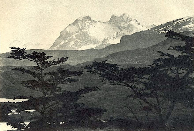
CERRO BALMACEDA PHOTOGRAPHED BY ROBERT GERSTMANN


ROBERT GERSTMANN (1896-1960), Cerro Balmaceda  (2,035 m  - 6,677 ft) Chile  In "Cerro Balmaceda",  glass plate, 1932, University of Antofagasta.

ROBERT GERSTMANN (1896-1960)
Cerro Balmaceda  (2,035 m  - 6,677 ft)
Chile

In "Cerro Balmaceda",  glass plate, 1932, University of Antofagasta.


The photographer
Robert Gerstmann was a photographer very famous in South America. Gerstmann was a Vienna born electrical engineer who, as a young man, developed an interest in photography. In 1924, he immigrated to Chile and from there traveled to Bolivia, where he made some 5000 photographs, a selection of which appear as photogravures in his Bolivia, 150 Grabados en Cobre (1928), which was reissued in 1996 by the Fundación Quipus in La Paz. Gerstmann ranged far, photographing the altiplano from La Paz south to the Argentine border, west to the Chilean border, and east to the Yungas, Cochabamba, Santa Cruz, and the lowlands along the Ríos Beni and Mamoré. Only Tarija and the Chaco escaped his lens. Five of his photographs illustrate Stewart E. McMillan's "The Heart of Aymara Land" National Geographic Magazine (February 1927), and several appear in Gustavo-Adolfo Otero's Bolivia (Guía Sinóptica) 1929. Gerstmann settled in Santiago in 1929. He published other photo albums, including Chile: 280 grabados en cobre (1932), Colombia: 200 grabados en cobre (1951), and Chile en 110 cuadros (1960?), and dabbled in film-making in Bolivia. He is thought to have died in Santiago ca. 1960. Several thousand of his glass plates are said to be at a university in Antofagasta.


The mountain
Cerro Balmaceda (2,035 m - 6,677 ft) is a heavily glaciated mountain located in the Magallanes Region of Chile. It stands at the head of Última Esperanza Sound, in the south portion of Bernardo O'Higgins National Park and near the mouth of the Serrano River. The glaciers Balmaceda and Serrano mantle the slopes of the mount.  In its vicinity is Torres del Paine National Park.
_______________________________
2022 - Wandering Vertexes...
by Francis Rousseau

Tuesday, October 4, 2022

WUDANGSHAN / 武当山 PAINTED BY JEAN-BAPTISTE NÉE


JEAN-BAPTISTE NÉE (b.1986) Wudangshan / 武当山 ( 1,610m - 5, 282 ft) China (Hubei)   In "Wudangshan (X)," lavis, 2018, 28x38cm

 JEAN-BAPTISTE NÉE (b.1986)
Wudangshan / 武当山 ( 1,610m - 5, 282 ft)
China (Hubei)

In "Wudangshan (X)," lavis, 2018, 28 x 38cm, 
Collection privée ©Jean-Baptiste Née
@jeanbaptiste.nee

The artist
Jean-Baptiste Née, born in 1986. is a french painter, scenographer and visual artist, graduated from Arts-Décoratifs of Paris in 2012. Jean-Baptiste Née works in the mountains and high mountains, always in situ, in direct confrontation with the movements of the earth and water and wind. He gives a growing place for the action of the elements on the work in progress (rain, snow, frost, etc.). He established his "large workshop" in the Swiss Alps or in the Vercors massif - especially in winter -, as well as during long hikes in the Italian Alps. In the winter of 2018, he worked in the massifs of Wudangshan and Lushan, in China, (see above) and became interested in the Taoist notion of "Sky" (t’ien 天).Since 2016, Jean-Baptiste Née exhibits regularly in galleries in France and Switzerland. His workshop is in Montreuil, France.

The mountains
The Wudang Mountains /武当山 (1,610m - consist of a mountain range in the northwestern part of Hubei, China, just south of Shiyan. They are home to a famous complex of Taoist temples and monasteries associated with the Lord of the North, Xuantian Shangdi. The Wudang Mountains are renowned for the practice of Tai chi and Taoism as the Taoist counterpart to the Shaolin Monastery, which is affiliated with Chinese Chán Buddhism. The Wudang Mountains are one of the "Four Sacred Mountains of Taoism" in China, an important destination for Taoist pilgrimages. The monasteries such as the Wudang Garden were made a UNESCO World Heritage Site in 1994 because of their religious significance and architectural achievement.  On Chinese maps, the name "Wudangshan" is applied both to the entire mountain range (which runs east-west along the southern edge of the Han River, crossing several county-level divisions of Shiyan), and to the group of peaks located within Wudangshan subdistrict of Danjiangkou, Shiyan. It is the latter specific area which is known as a Taoist center.  ome consider the Wudang Mountains to be a "branch" of the Daba Mountains range, which is a major mountain system in western Hubei, Shaanxi, Chongqing and Sichuan.
____________________________________

2022- Wandering Vertexes.
A blog by Francis Rousseau

Saturday, October 1, 2022

SAN MINIATO HILLS PAINTED BY JOHN HENRY TWACHTMAN


JOHN HENRY TWACHTMAN (1853-1902) San Miniato Hills (140m) Italy (Tuscanny)  In San Miniato Hills (140m) 1892, oil on painting, 22 x 48cm, Private collection, New York
 
JOHN HENRY TWACHTMAN (1853-1902)
San Miniato Hills (140m - 459 ft))
Italy (Tuscanny)

In San Miniato Hills, 1892, oil on painting, 22 x 48cm, Private collection, New York


The hills
San Miniato sits at an historically strategic location atop three small hills (140m - 459 ft) where it dominates the lower Arno valley, between the valleys of Egola and Elsa rivers. Miniato is a town in the province of Pisa, in the region of Tuscany, ItalyIt used to carry the additional sobriquet al Tedesco ("to the German") to distinguish it from the convent of San Miniato al Monte in Florence, which is about 40 kilometres (25 mi) to the northeast. In medieval times, San Miniato was on the via Francigena, which was the main connecting route between northern Europe and Rome. It also sits at the intersection of the Florence-Pisa and the Lucca-Siena roads. Over the centuries San Miniato was therefore exposed to a constant flow of friendly and hostile armies, traders in all manner of goods and services, and other travelers from near and far. Archaeological evidence indicates that the site of the city and surrounding area has been settled since at least the paleolithic era. It would have been well known to the Etruscans, and certainly to the Romans, for whom it was a military post called "Quarto".

The painter
John Henry Twachtman was an American painter best known for his impressionist landscapes, though his painting style varied widely through his career. Art historians consider Twachtman's style of American Impressionism to be among the more personal and experimental of his generation. Twachtman was born in Cincinnati, Ohio and received his first art training there, including studying under Frank Duveneck. Like some white artists of means and European heritage of the era, Twachtman then proceeded to Europe to further his education. He enrolled in the Academy of Fine Arts in Munich in 1875 and visited Venice with Duveneck and William Merritt Chase in 1878. His landscapes from this time exhibit the loosely brushed, shadowy technique taught at Munich. Twachtman also learned etching, and sometimes carried etching plates with him that he could use to spontaneously record a scene. After a brief return to America, Twachtman studied from 1883 to 1885 at the Académie Julian in Paris, and his paintings dramatically shifted towards a soft, gray and green tonalist style. During this time he painted what some art historians consider to be his greatest masterpieces, including Arques-la-Bataille, in the collection of the Metropolitan Museum of Art in New York, and Springtime, in the collection of the Cincinnati Art Museum. In 1886 he returned to America. In 1890, he bought a farm in Greenwich. He often painted and exhibited with fellow artist Julian Alden Weir, and spent considerable time at the art colony in Cos Cob. His presence was vital to the colony. In addition to his oil paintings, Twachtman produced drawings in pastel. He taught painting at the Art Students League from 1889 until his death in 1902. Twachtman was close friends with Julian Alden Weir and the two often painted together. In Connecticut his painting style shifted again, this time to a highly personal impressionist technique. Twachtman painted many landscapes of his farm and garden in Greenwich, often depicting the snow-covered landscape. He executed dozens of paintings of a small waterfall on his property, capturing the scene in different seasons and times of day. In the summers of 1900–1902, Twachtman visited Gloucester, Massachusetts, another center of artistic activity in the era, and produced a series of vibrant scenes that anticipated a more modernist style yet to gain prominence in American art. Twachtman died suddenly in Gloucester of a brain aneurysm, aged 49. Today, his works are in many museum collections including the Metropolitan Museum of Art, New York; the National Gallery of Art, Washington, D.C.; and the Museum of Fine Arts, Boston.
___________________________________________
2022 - Wandering Vertexes...
by Francis Rousseau