google.com, pub-0288379932320714, DIRECT, f08c47fec0942fa0 GRAVIR LES MONTAGNES... EN PEINTURE: CHARLES HAMILTON SMITH (1776-1859)
Showing posts with label CHARLES HAMILTON SMITH (1776-1859). Show all posts

Monday, March 6, 2023

PETOOWACK ARCTIC HIGHLANDS PEINT PAR CHARLES HAMILTON SMITH


CHARLES HAMILTON SMITH (1776-1859) Petoowack Arctic Highlands Formation (500 m) Antarctica  In Petoowack Arctic Highlands Formation, watercolor, Yale Center for British Art
 
CHARLES HAMILTON SMITH (1776-1859)
Petoowack Arctic Highlands Formation (500 m)
Antarctica

In Petoowack Arctic Highlands Formation, watercolor, Yale Center for British Art

L'artiste
Le lieutenant-colonel Charles Hamilton Smith, était un artiste anglais, naturaliste, antiquaire, illustrateur, soldat, et... aussi espion  !  Sa carrière militaire débute en 1787, lorsqu'il étudie à l'académie d'artillerie et de génie à Malines et Louvain en Belgique (son pays natal). Son service militaire, qui s'est terminé en 1820 et comprenait les guerres napoléoniennes, l'a vu beaucoup voyager (y compris les Antilles, le Canada, les États-Unis, l'Europe du Sud et du Nord et ... l'Antarctique).
Illustrateur autodidacte prolifique (plus de 38 000 dessins !), il a laissé un nombre assez important de livres de paysages magnifiquement aquarellés pris dans le monde entier. ces recoins d'aquarelles sont aujourd'hui dans les collections du Yale Center From British Art. Parmi eux :
- Vues de France, tome I (81 aquarelles), Vues de France, tome II (93 aquarelles),
- Vues d'Angleterre et du Pays de Galles, Tome I (82 aquarelles), Vues d'Angleterre et du Pays de Galles, Tome II (74 aquarelles),
- Vues d'Europe du Nord, Tome I (68 aquarelles), Vues d'Europe du Nord, Tome II (78 aquarelles),
- Vues des régions polaires (75 aquarelles) (voir ci-dessus)
- Vues d'Espagne, Volume I (69 aquarelles), Vues d'Espagne, Volume II (72 aquarelles), Mais l'une de ses réalisations remarquables fut une expérience de 1800 pour déterminer quelle couleur devait être utilisée pour les uniformes militaires. Il est également connu dans les cercles d'histoire militaire pour le costume de l'armée de l'Empire britannique, produit vers la fin des guerres napoléoniennes et une représentation précise de l'uniforme britannique contemporain.
En tant qu'antiquaire, il a également produit, en collaboration avec Samuel Rush Meyrick, Costume of the Original Inhabitants of the British Islands, 1815, et The Ancient Costume of England, avec des illustrations historiques de chevaliers médiévaux, de dames, de navires et de batailles.
Il a également écrit sur l'histoire de la guerre de Sept Ans et sur l'histoire naturelle des chiens.
Un type plutôt productif !
_________________________________________

2023 - Wandering Vertexes ....
Errant au-dessus des Sommets Silencieux...
Un blog de Francis Rousseau
Thursday, July 14, 2022

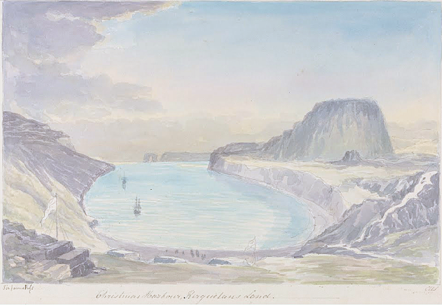
LA TABLE DE L'OISEAU SKETCHED BY CHARLES HAMILTON SMITH

CHARLES HAMILTON SMITH (1776-1859) La Table de l'Oiseau (403m - 1,322 ft) Antarctica - France   In Christmas Harbour,  Kerguelen's Land, watercolor,

CHARLES HAMILTON SMITH (1776-1859)
La Table de l'Oiseau (403m - 1,322 ft)
Antarctica - France

 In Christmas Harbour,  Kerguelen's Land, watercolor


The hill
The Table de l'Oiseau (403m - 1,322 ft) (Table ot the Bird) is a hill overlooking Port-Christmas by the north. Port-Christmas is one of the most isolated and difficult to reach points in the archipelagok.  Given the distance and especially the rugged topography, the site is almost never reached by land. However, it can be reached by sea after sailing for at least 100 nautical miles (190 km). The baie de l'Oiseau, at the bottom of which it is located, forms the first indentation at the northeast end of the Loranchet peninsula. The bay is closed to the north by Cap Français, to the south by Pointe de l'Arche (seen in the foreground).
While the shores of the bay are mostly rocky and often steep, the bottom is occupied by a strike, about 350 meters long, of black sand resulting from the erosion of the surrounding basaltic rocks. pours into the sea, after having collected runoff water from Mount Havergal on the one hand, and that from the outlet of Rochegude Lake on the other. This lake, located about 500 m from the shore and 40 m above sea level, marks the shoulder that separates Port-Christmas from Ducheyron Bay, to the west.
The anchorage at Port-Christmas allows you to anchor at a depth of 11 meters. It offers relatively safe shelter to sailors who frequent this particularly turbulent ocean sector of the Roaring Forties.

The artist
Lieutenant-Colonel Charles Hamilton Smith, was an English artist, naturalist, antiquary, illustrator, soldier, and... spy as well !. His military career began in 1787, when he studied at the Austrian academy for artillery and engineers at Mechelen and Leuven in Belgium (his native country). Although his military service, which ended in 1820 and included the Napoleonic Wars, saw him travel extensively (including the West Indies, Canada, United States, Southern and Northern Europe and ...Antarctica).
As a prolific self-taught illustrator (over 38,000 drawings!) He left quite an important number of books of beautifully watercolored landscapes taken all around the world. those nooks of watercolors are nowadays in the collections of the Yale Center From British Art. Among them :
- Views of France, Volume I (81 watercolors), Views of France, Volume II (93 watercolors),
- Views of England and Wales, Volume I (82 watercolors), Views of England and Wales, Volume II (74 watercolors),
- Views of Northern Europe, Volume I (68 watercolors), Views of Northern Europe, Volume II (78) watercolors),
- Views of Polar Regions (75 watercolors) (see above)
- Views of Spain, Volume I (69 watercolors), Views of Spain, Volume II (72 watercolors), But one of his noteworthy achievements was an 1800 experiment to determine which color should be used for military uniforms. He is also known in military history circles for Costume of the Army of the British Empire, produced towards the end of the Napoleonic Wars and an accurate depiction of contemporary British uniform.
As an antiquarian, he also produced, in collaboration with Samuel Rush Meyrick, Costume of the Original Inhabitants of the British Islands, 1815, and The Ancient Costume of England, with historical illustrations of medieval knights, ladies, shipsm and battles.
He also wrote on the history of the Seven Years' War and The Natural history of dogs.
Quite a productive fellow !
___________________________________________

2022 - Wandering Vertexes...
by Francis Rousseau

Sunday, August 8, 2021

NEWTONTOPPEN ( SPITZBERGEN) BY CHARLES HAMILTON SMITH


CHARLES HAMILTON SMITH (1776-1859) Newtontoppen (1,713 m - 5,620ft) Norway (Svalbard- Spitzbergen)  In Spitzbergen, Bearing South,  watercolor and graphite from Views of Polar region, Yale Center for British arts, USA


CHARLES HAMILTON SMITH (1776-1859)
Newtontoppen (1,713 m - 5,620ft)
Norway (Svalbard- Spitzbergen)

In Spitzbergen, Bearing South,  watercolor and graphite from Views of Polar region, Yale Center for British arts, USA

The mountain
Newtontoppen  (1,713 m - 5,620ft) or Newton Peak, named in 1898 after Isaac Newton, is the largest and highest mountain in Svalbard. Its peak is the highest point on Svalbard.  It is located at the north east corner on the island of Spitsbergen in the Chydeniusfjella range.  The nearest settlement is the formerly Soviet coal mining settlement, Pyramiden. The mountain is mostly made of Silurian granite. The mountain was first ascended by Helge Backlund on 4 August 1900.  Spitsbergen, (sharp mountains) is an island belonging to Norway and located in Svalbard, an archipelago forming a territory of this country. The island bears the name of Spitsbergen since1920, date of the signing of the treaty which regulates in particular fishing rights (whaling among others). The treaty signed by the United States, the United Kingdom, Denmark, France, Italy, Japan, Norway, the Netherlands and Sweden, leads all the contracting states to recognize the sovereignty of Norway over this territory.  France has two scientific research stations at Spitzbergen: the Charles Rabot base and the Jean Corbel base, the latter (created in 1964) being the oldest of the archipelago's scientific stations.
Spitsbergen was discovered by chance by Dutch explorer Willem Barentsz in 1596 while en route to China via the Northeast Passage. He then named the island Spitsbergen in reference to the craggy peaks he saw.  Nevertheless, the archipelago seems to have been known by Russian Pomor hunters as early as the 12th and 14th centuries. Tourism is nowadays  one of Spitsbergen's main sources of income with cruise ships, including those of the Hurtigruten company. The island is also served by the airports of Longyearbyen and Ny-Ålesund.

The artist
Lieutenant-Colonel Charles Hamilton Smith, was an English artist, naturalist, antiquary, illustrator, soldier, and... spy as well !. His military career began in 1787, when he studied at the Austrian academy for artillery and engineers at Mechelen and Leuven in Belgium (his native country). Although his military service, which ended in 1820 and included the Napoleonic Wars, saw him travel extensively (including the West Indies, Canada, United States, Southern and Northern Europe and ...Antarctica).
As a prolific self-taught illustrator (over 38,000 drawings!) He left quite an important number of books of beautifully watercolored landscapes taken all around the world. those nooks of watercolors are nowadays in the collections of the Yale Center From British Art. Among them :
- Views of France, Volume I (81 watercolors), Views of France, Volume II (93 watercolors),
- Views of England and Wales, Volume I (82 watercolors), Views of England and Wales, Volume II (74 watercolors),
- Views of Northern Europe, Volume I (68 watercolors), Views of Northern Europe, Volume II (78) watercolors),
- Views of Polar Regions (75 watercolors) (see above)
- Views of Spain, Volume I (69 watercolors), Views of Spain, Volume II (72 watercolors), But one of his noteworthy achievements was an 1800 experiment to determine which color should be used for military uniforms. He is also known in military history circles for Costume of the Army of the British Empire, produced towards the end of the Napoleonic Wars and an accurate depiction of contemporary British uniform.
As an antiquarian, he also produced, in collaboration with Samuel Rush Meyrick, Costume of the Original Inhabitants of the British Islands, 1815, and The Ancient Costume of England, with historical illustrations of medieval knights, ladies, shipsm and battles.
He also wrote on the history of the Seven Years' War and The Natural history of dogs.
Quite a productive fellow !

___________________________________________

2021 - Wandering Vertexes...
by Francis Rousseau


Saturday, October 10, 2020

MOUNT HAWKES / HAWKES HEIGHTS BY CHARLES HAMILTON SMITH


CHARLES HAMILTON SMITH (1776-1859), Mount Hawkes / Hawkes Heights ( 2,000 m- 6,600 ft) Antarctic (Coulman Island)  In Coulman Island, discovered Jan.4. 1844, watercolor on paper,Yale Center for BRitish Art, New Haven, USA

CHARLES HAMILTON SMITH (1776-1859),
Mount Hawkes / Hawkes Heights (2,000 m- 6,600 ft)
Antarctic (Coulman Island)

In Coulman Island, discovered Jan.4. 1844, watercolor on paper,
Yale Center for BRitish Art, New Haven, USA


The mountain
Mount Hawkes ( 2,000 m- 6,600 ft) also called  Hawkes Heights  is an ice-filled volcanic crater that dominates the southern part of Coulman Island, in the Ross Sea, Antarctica and marks the island's summit. The feature was named by the New Zealand Geological Survey Antarctic Expedition (NZGSAE), 1958–59, for Captain William M. Hawkes, U.S. Navy, who took a leading part in early air operations from Williams Field near McMurdo Station, including long range photo reconnaissance and supply flights, and the first air landing at the South Pole. He was commander of one of the two planes which made the historic first flight from Christchurch to McMurdo Station on December 17, 1955. His air photos proved of great value to two NZGSAE parties to this part of Victoria Land. Mount Hawkes is also named for Hawkes, who was assigned to Air Development Squadron Six (VX-6) in 1955–56.


The artist
Lieutenant-Colonel Charles Hamilton Smith, was an English artist, naturalist, antiquary, illustrator, soldier, and... spy as well !. His military career began in 1787, when he studied at the Austrian academy for artillery and engineers at Mechelen and Leuven in Belgium (his native country). Although his military service, which ended in 1820 and included the Napoleonic Wars, saw him travel extensively (including the West Indies, Canada, United States, Southern and Northern Europe and ...Antarctica).
As a prolific self-taught illustrator (over 38,000 drawings!) He left quite an important number of books of beautifully watercolored landscapes taken all around the world. those nooks of watercolors are nowadays in the collections of the Yale Center From British Art. Among them :
- Views of France, Volume I (81 watercolors), Views of France, Volume II (93 watercolors),
- Views of England and Wales, Volume I (82 watercolors), Views of England and Wales, Volume II (74 watercolors),
- Views of Northern Europe, Volume I (68watercolors) , Views of Northern Europe, Volume II (78) watercolors),
- Views of Polar Regions (75 watercolors) (see above)
- Views of Spain, Volume I (69 watercolors), Views of Spain, Volume II (72 watercolors), But one of his noteworthy achievements was an 1800 experiment to determine which color should be used for military uniforms. He is also known in military history circles for Costume of the Army of the British Empire, produced towards the end of the Napoleonic Wars and an accurate depiction of contemporary British uniform.
As an antiquarian, he also produced, in collaboration with Samuel Rush Meyrick, Costume of the Original Inhabitants of the British Islands, 1815, and The Ancient Costume of England, with historical illustrations of medieval knights, ladies, shipsm and battles.
He also wrote on the history of the Seven Years' War and The Natural history of dogs.
Quite a productive fellow !

___________________________________________

2020 - Wandering Vertexes...
by Francis Rousseau

Monday, April 6, 2020

CRIMSON CLIFFS GREENLAND BY CHARLES HAMILTON SMITH


CHARLES HAMILTON SMITH  (1776-1859) 
Crimson Cliffs (300 m- 984 ft) 
Danemark- Greenland

  In  Red Snow along cliffs in Greenland - Watercolour from  Views of Polar region, Yale Center for British arts- Connectitcut, USA

The Cliffs
Crimson Cliffs ( 300m) are a cape on the northwestern coast of Greenland, in northern Baffin Bay.Crimson Cliffs are located west of Cape York, an important geographical landmark that delimits the northwestern end of Melville Bay, with the other end commonly defined as Wilcox Head, the western promontory on Kiatassuaq Island.
Red snow or blood snow  also called or watermelon snow, pink snow or snow algae is a phenomenon caused by Chlamydomonas nivalis, a species of green algae containing a secondary red carotenoid pigment (astaxanthin) in addition to chlorophyll. Unlike most species of fresh-water algae, it is cryophilic (cold-loving) and thrives in freezing water.
This type of snow is common during the summer in alpine and coastal polar regions worldwide, such as the Sierra Nevada of California. Here, at altitudes of 10,000 to 12,000 feet (3,000–3,600 m), the temperature is cold throughout the year, and so the snow has lingered from winter storms. Compressing the snow by stepping on it or making snowballs leaves it looking red. Walking on watermelon snow often results in getting bright red soles and pinkish trouser cuffs.
 "By August first he had reached a point near the Petowik glacier which lies just northward of the "Crimson Cliffs" of Sir John Ross. This is so called from the fact that on the snow-clad cliffs and glacier surfaces at this point Sir John Ross, in 1818, discovered a red deposit which had fallen about and mixed with the snow, giving it a reddish color which was pretty widely distributed. What was it? For a long time this was a mystery, but it was at last proven to be of vegetable origin: now, the point--to be taken up in detail later is simply this: where could any vegetable matter, either a pollen from larger plants or a very humble sort of red mossy or spore like growth, come from? There is no other case in the whole realm of botany that would justify us in assuming that a plant can grow on ice-bergs or on snow. A plant requires certain elements and certain temperatures. Evidently, somewhere those factors must be in existence. Where, we shall see later."
Excerpt form "Three Years of Arctic Service", by General A. W. Greely, 1881

The artist
Lieutenant-Colonel Charles Hamilton Smith, was an English artist, naturalist, antiquary, illustrator, soldier, and... spy as well !. His military career began in 1787, when he studied at the Austrian academy for artillery and engineers at Mechelen and Leuven in Belgium (his native country). Although his military service, which ended in 1820 and included the Napoleonic Wars, saw him travel extensively (including the West Indies, Canada, United States, Southern and Northern Europe and ...Antarctica).
As a prolific self-taught illustrator (over 38,000 drawings!) He left quite an important number of books of beautifully watercolored landscapes taken all around the world. those nooks of watercolors are nowadays in the collections of the Yale Center From British Art. Among them :
- Views of France, Volume I (81 watercolors), Views of France, Volume II (93 watercolors),
- Views of England and Wales, Volume I (82 watercolors), Views of England and Wales, Volume II (74 watercolors),
- Views of Northern Europe, Volume I (68watercolors) , Views of Northern Europe, Volume II (78) watercolors),
- Views of Polar Regions (75 watercolors) (see above)
- Views of Spain, Volume I (69 watercolors), Views of Spain, Volume II (72 watercolors), But one of his noteworthy achievements was an 1800 experiment to determine which color should be used for military uniforms. He is also known in military history circles for Costume of the Army of the British Empire, produced towards the end of the Napoleonic Wars and an accurate depiction of contemporary British uniform.
As an antiquarian, he also produced, in collaboration with Samuel Rush Meyrick, Costume of the Original Inhabitants of the British Islands, 1815, and The Ancient Costume of England, with historical illustrations of medieval knights, ladies, shipsm and battles.
He also wrote on the history of the Seven Years' War and The Natural history of dogs.
Quite a productive fellow !

___________________________________________

2020 - Wandering Vertexes...
by Francis Rousseau


Monday, January 13, 2020

MOUNT TACOMA / MOUNT RAINIER BY CHARLES HAMILTON SMITH


CHARLES HAMILTON SMITH (1776-1859)
Mount Tacoma / Mont Rainier (4,392 m -14,411 ft)
United States of America (Washington)

In Mount Rainier from the South Part of Admiralty Inlet, Watercolor and graphite from Views of Polar region, Yale Center for British arts, Connectitcut USA.

The mountain
Mount Rainier, Mount Tacoma, or Mount Tahoma (4,392 m-14,411 ft) is the highest mountain of the Cascade Range of the Pacific Northwest, and the highest mountain in the U.S. state of Washington. It is a large active stratovolcano located 54 miles (87 km) south-southeast of Seattle. It is the most topographically prominent mountain in the contiguous United States and the Cascade Volcanic Arc.
Mount Rainier was first known by the Native Americans as Talol, or Tacoma or Tahoma.
The current name was given by George Vancouver, who named it in honor of his friend, Rear Admiral Peter Rainier. The map of the Lewis and Clark expedition of 1804-1806 refers to it as "Mt. Regniere". Mount Rainier is ranked third of the 128 ultra-prominent mountain peaks of the United States.
With 26 major glaciers and 36 sq mi (93 km2) of permanent snowfields and glaciers, Mount Rainier is the most heavily glaciated peak in the lower 48 states. The summit is topped by two volcanic craters, each more than 1,000 ft (300 m) in diameter, with the larger east crater overlapping the west crater. Geothermal heat from the volcano keeps areas of both crater rims free of snow and ice, and has formed the world's largest volcanic glacier cave network within the ice-filled craters, with nearly 2 mi (3.2 km) of passages. The Carbon, Puyallup, Mowich, Nisqually, and Cowlitz Rivers begin at eponymous glaciers of Mount Rainier. The sources of the White River are Winthrop, Emmons, and Fryingpan Glaciers. The White, Carbon, and Mowich join the Puyallup River, which discharges into Commencement Bay at Tacoma; the Nisqually empties into Puget Sound east of Lacey; and the Cowlitz joins the Columbia River between Kelso and Longview.

The artist
Lieutenant-Colonel Charles Hamilton Smith, was an English artist, naturalist, antiquary, illustrator, soldier, and... spy as well !. His military career began in 1787, when he studied at the Austrian academy for artillery and engineers at Mechelen and Leuven in Belgium (his native country). Although his military service, which ended in 1820 and included the Napoleonic Wars, saw him travel extensively (including the West Indies, Canada, United States, Southern and Northern Europe and ...Antarctica).
As a prolific self-taught illustrator (over 38,000 drawings!) He left quite an important number of books of beautifully watercolored landscapes taken all around the world. those nooks of watercolors are nowadays in the collections of the Yale Center From British Art. Among them :
- Views of France, Volume I (81 watercolors), Views of France, Volume II (93 watercolors),
- Views of England and Wales, Volume I (82 watercolors), Views of England and Wales, Volume II (74 watercolors),
- Views of Northern Europe, Volume I (68watercolors) , Views of Northern Europe, Volume II (78) watercolors),
- Views of Polar Regions (75 watercolors) (see above)
- Views of Spain, Volume I (69 watercolors), Views of Spain, Volume II (72 watercolors), But one of his noteworthy achievements was an 1800 experiment to determine which color should be used for military uniforms. He is also known in military history circles for Costume of the Army of the British Empire, produced towards the end of the Napoleonic Wars and an accurate depiction of contemporary British uniform.
As an antiquarian, he also produced, in collaboration with Samuel Rush Meyrick, Costume of the Original Inhabitants of the British Islands, 1815, and The Ancient Costume of England, with historical illustrations of medieval knights, ladies, shipsm and battles.
He also wrote on the history of the Seven Years' War and TheNatural history of dogs.
Quite a productive fellow !

___________________________________________ 


2020 - Wandering Vertexes...
by Francis Rousseau


Tuesday, December 24, 2019

MOUNT SAINT ELIAS BY CHARLES HAMILTON SMITH


CHARLES HAMILTON SMITH (1776-1859)
Mount Saint Elias (5,489 m- 18,008 ft)
United States of America (Alaska) - Canada (Yukon) border

In  Icy Bay & Mount Saint Elias (Alaska,) watercolor and graphite from Views of Polar region
Yale Center for British arts 

The mountain
Mount Saint Elias  (5,489 m- 18,008 ft) also designated  as Boundary Peak 186 is the second highest mountain in both Canada and the United States, being situated on the Yukon and Alaska border.
It lies about 26 miles (42 km) southwest of Mount Logan,  the highest mountain in Canada. The Canadian side is part of Kluane National Park and Reserve, while the U.S. side of the mountain is located within Wrangell-St. Elias National Park and Preserve.
Its name in Tlingit is Yasʼéitʼaa Shaa, meaning "mountain behind Icy Bay", and is occasionally called Shaa Tlein "Big Mountain" by the Yakutat Tlingit. It is one of the most important crests of the Kwaashkʼiḵwáan clan since they used it as a guide during their journey down the Copper River.
The mountain was first sighted by European explorers on July 16, 1741 by Vitus Bering of Russia. While some historians contend that the mountain was named by Bering, others believe that eighteenth century mapmakers named it after Cape Saint Elias, when it was left unnamed by Bering.
Mount Saint Elias is notable for its immense vertical relief vertically in just 10 miles (16 km) horizontal distance from the head of Taan Fjord, off of Icy Bay.

The artist 
Lieutenant-Colonel Charles Hamilton Smith,  was an English artist, naturalist, antiquary, illustrator, soldier, and... spy as well !. His military career began in 1787, when he studied at the Austrian academy for artillery and engineers at Mechelen and Leuven in Belgium (his native country). Although his military service, which ended in 1820 and included the Napoleonic Wars, saw him travel extensively (including the West Indies, Canada, United States, Southern and Northern Europe and ...Antarctica).
As a prolific self-taught illustrator (over 38,000 drawings!) He left quite an important number of books of  beautifully watercolored landscapes taken all around the world. those nooks of watercolors are nowadays in the collections of  the Yale Center From British Art. Among them  :
Views of France, Volume I (81 watercolors), Views of France, Volume II (93 watercolors), 
Views of England and Wales, Volume I (82  watercolors),  Views of England and Wales, Volume II (74  watercolors),
Views of Northern Europe, Volume I (68watercolors) , Views of Northern Europe, Volume II (78)  watercolors),  
Views of Polar Regions (75  watercolors) (see above) 
Views of Spain, Volume I (69 watercolors), Views of Spain, Volume II (72 watercolors), 
But one of his noteworthy achievements was an 1800 experiment to determine which color should be used for military uniforms.  He is also known in military history circles for Costume of the Army of the British Empire, produced towards the end of the Napoleonic Wars and an accurate depiction of contemporary British uniform.
As an antiquarian, he also produced, in collaboration with Samuel Rush Meyrick, Costume of the Original Inhabitants of the British Islands, 1815, and The Ancient Costume of England, with historical illustrations of medieval knights, ladies, shipsm and battles. 
He also wrote on the history of the Seven Years' War and TheNatural history of dogs.
Quite a productive fellow !

______________________________________
2019 - Wandering Vertexes...
by Francis Rousseau

Monday, November 11, 2019

MOUNT SABINE BY CHARLES HAMILTON SMITH


CHARLES HAMILTON SMITH (1776-1859)
Mount Sabine  (3,729m - 12, 205 ft) 
Antarctica (Victoria Land) 

In Mount Sabine and Possession Islands -  Watercolour from  Views of Polar region
Yale Center for British arts

The mountain
Mount Sabine (3,729m - 12, 205 ft)  is a prominent, relatively snow-free mountain rising between the heads of Murray Glacier and Burnette Glacier. Discovered on January 11, 1841, by Captain James Ross, Royal Navy, who named this feature for Lieutenant Colonel Edward Sabine of the Royal Artillery, Foreign Secretary of the Royal Society, one of the most active supporters of the expedition.
Mount Sabine is part of The Admiralty Mountains (alternatively Admiralty Range), a large group of high mountains and individually named ranges and ridges in northeastern Victoria Land, Antarctica. This mountain group is bounded by the Ross Sea, the Southern Ocean, and by the Dennistoun, Ebbe, and Tucker glaciers. The mountain range is situated on the Pennell Coast, a portion of Antarctica lying between Cape Williams and Cape Adare.
The Admiralty Mountains are divided into the Dunedin Range, Homerun Range, and Lyttelton Range and named them for the Lords Commissioners of the Admiralty under whose orders Captain James Ross served.

The artist 
Lieutenant-Colonel Charles Hamilton Smith,  was an English artist, naturalist, antiquary, illustrator, soldier, and... spy as well !. His military career began in 1787, when he studied at the Austrian academy for artillery and engineers at Mechelen and Leuven in Belgium (his native country). Although his military service, which ended in 1820 and included the Napoleonic Wars, saw him travel extensively (including the West Indies, Canada, United States, Southern and Northern Europe and ...Antarctica).
As a prolific self-taught illustrator (over 38,000 drawings!) He left quite an important number of books of  beautifully watercolored landscapes taken all around the world. those nooks of watercolors are nowadays in the collections of  the Yale Center From British Art. Among them  :
Views of France, Volume I (81 watercolors), Views of France, Volume II (93 watercolors), 
Views of England and Wales, Volume I (82  watercolors),  Views of England and Wales, Volume II (74  watercolors),
Views of Northern Europe, Volume I (68watercolors) , Views of Northern Europe, Volume II (78)  watercolors),  
Views of Polar Regions (75  watercolors) (see above) 
Views of Spain, Volume I (69 watercolors), Views of Spain, Volume II (72 watercolors), 
But one of his noteworthy achievements was an 1800 experiment to determine which color should be used for military uniforms.  He is also known in military history circles for Costume of the Army of the British Empire, produced towards the end of the Napoleonic Wars and an accurate depiction of contemporary British uniform.
As an antiquarian, he also produced, in collaboration with Samuel Rush Meyrick, Costume of the Original Inhabitants of the British Islands, 1815, and The Ancient Costume of England, with historical illustrations of medieval knights, ladies, shipsm and battles. 
He also wrote on the history of the Seven Years' War and TheNatural history of dogs.
Quite a productive fellow !

__________________________________________
2019 - Wandering Vertexes...
by Francis Rousseau

Wednesday, October 23, 2019

MOUNT EREBUS BY CHARLES HAMILTON SMITH

 
CHARLES HAMILTON SMITH (1776-1859) 
Mont Erebus (3, 794 m - 12, 448ft)
Antarctica (Ross Island)
In Mount Erebus and Beaufort Island- Watercolour from Views of Polar region, 
 Yale Center for British arts, Connectitcut, USA


The mountain
Mount Erebus (3, 794 m - 12, 448ft), not to be confused with Mount Elbrus is the second-highest volcano in Antarctica (after Mount Sidley) and the southernmost active volcano on Earth. It is the sixth highest ultra mountain on an island, located on Ross Island, which is also home to three inactive volcanoes: Mount Terror, Mount Bird, and Mount Terra Nova.
The volcano has been active since c. 1.3 million years ago and is the site of the Mount Erebus Volcano Observatory run by the New Mexico Institute of Mining and Technology.
Mount Erebus was discovered on January 27, 1841 (and observed to be in eruption) by polar explorer Sir James Clark Ross who named it and its companion, Mount Terror, after his ships, Erebus and Terror (which were later used by Sir John Franklin on his disastrous Arctic expedition). Erebus is a dark region in Hades in Greek mythology. Present with Ross on the Erebus was the young Joseph Hooker, future president of the Royal Society and close friend of Charles Darwin. Erebus was an Ancient Greek primordial deity of darkness, the son of Chaos.
The mountain was surveyed in December 1912 by a science party from Scott’s Terra Nova Expedition who also collected geological samples. Two of the camp sites they used have been recognised for their historic significance:
- Upper “Summit Camp” site (HSM 89) consists of part of a circle of rocks, which were probably used to weight the tent valances.
- Lower “Camp E” site (HSM 90) consists of a slightly elevated area of gravel as well as some aligned rocks, which may have been used to weight the tent valances.
They have been designated Historic Sites or Monuments following a proposal by the United Kingdom, New Zealand and the United States to the Antarctic Treaty Consultative Meeting.
Mount Erebus is classified as a polygenetic stratovolcano. The bottom half of the volcano is a shield and the top half is a stratocone. The composition of the current eruptive products of Erebus is anorthoclase-porphyritic tephritic phonolite and phonolite, which are the bulk of exposed lava flow on the volcano. Erebus is the world's only presently erupting phonolite volcano.

The artist 
Lieutenant-Colonel Charles Hamilton Smith,  was an English artist, naturalist, antiquary, illustrator, soldier, and... spy as well !. His military career began in 1787, when he studied at the Austrian academy for artillery and engineers at Mechelen and Leuven in Belgium (his native country). Although his military service, which ended in 1820 and included the Napoleonic Wars, saw him travel extensively (including the West Indies, Canada, United States, Southern and Northern Europe and ...Antarctica).
As a prolific self-taught illustrator (over 38,000 drawings!) He left quite an important number of books of  beautifully watercolored landscapes taken all around the world. those nooks of watercolors are nowadays in the collections of  the Yale Center From British Art. Among them  :
Views of France, Volume I (81 watercolors), Views of France, Volume II (93 watercolors), 
Views of England and Wales, Volume I (82  watercolors),  Views of England and Wales, Volume II (74  watercolors),
Views of Northern Europe, Volume I (68watercolors) , Views of Northern Europe, Volume II (78)  watercolors),  
Views of Polar Regions (75  watercolors) (see above) 
Views of Spain, Volume I (69 watercolors), Views of Spain, Volume II (72 watercolors), 
But one of his noteworthy achievements was an 1800 experiment to determine which color should be used for military uniforms.  He is also known in military history circles for Costume of the Army of the British Empire, produced towards the end of the Napoleonic Wars and an accurate depiction of contemporary British uniform.
As an antiquarian, he also produced, in collaboration with Samuel Rush Meyrick, Costume of the Original Inhabitants of the British Islands, 1815, and The Ancient Costume of England, with historical illustrations of medieval knights, ladies, shipsm and battles. 
He also wrote on the history of the Seven Years' War and TheNatural history of dogs.
Quite a productive fellow ! 
___________________________________________
2019 - Wandering Vertexes...
by Francis Rousseau

Wednesday, October 2, 2019

EREBUS SEEN BY CHARLES HAMILTON SMITH


CHARLES HAMILTON SMITH (1776-1859) 
Mont Erebus (3, 794 m - 12, 448ft)
Antarctica (Ross Island)

In Mount Erebus- Watercolour from Views of Polar region, Yale Center for British arts, Connectitcut,USA


The mountain
Mount Erebus (3, 794 m - 12, 448ft), not to be confused with Mount Elbrus is the second-highest volcano in Antarctica (after Mount Sidley) and the southernmost active volcano on Earth. It is the sixth highest ultra mountain on an island, located on Ross Island, which is also home to three inactive volcanoes: Mount Terror, Mount Bird, and Mount Terra Nova.
The volcano has been active since c. 1.3 million years ago and is the site of the Mount Erebus Volcano Observatory run by the New Mexico Institute of Mining and Technology.
Mount Erebus was discovered on January 27, 1841 (and observed to be in eruption) by polar explorer Sir James Clark Ross who named it and its companion, Mount Terror, after his ships, Erebus and Terror (which were later used by Sir John Franklin on his disastrous Arctic expedition). Erebus is a dark region in Hades in Greek mythology. Present with Ross on the Erebus was the young Joseph Hooker, future president of the Royal Society and close friend of Charles Darwin. Erebus was an Ancient Greek primordial deity of darkness, the son of Chaos.
The mountain was surveyed in December 1912 by a science party from Scott’s Terra Nova Expedition who also collected geological samples. Two of the camp sites they used have been recognised for their historic significance:
- Upper “Summit Camp” site (HSM 89) consists of part of a circle of rocks, which were probably used to weight the tent valances.
- Lower “Camp E” site (HSM 90) consists of a slightly elevated area of gravel as well as some aligned rocks, which may have been used to weight the tent valances.
They have been designated Historic Sites or Monuments following a proposal by the United Kingdom, New Zealand and the United States to the Antarctic Treaty Consultative Meeting.
Mount Erebus is classified as a polygenetic stratovolcano. The bottom half of the volcano is a shield and the top half is a stratocone. The composition of the current eruptive products of Erebus is anorthoclase-porphyritic tephritic phonolite and phonolite, which are the bulk of exposed lava flow on the volcano. Erebus is the world's only presently erupting phonolite volcano.

The artist 
Lieutenant-Colonel Charles Hamilton Smith,  was an English artist, naturalist, antiquary, illustrator, soldier, and... spy as well !. His military career began in 1787, when he studied at the Austrian academy for artillery and engineers at Mechelen and Leuven in Belgium (his native country). Although his military service, which ended in 1820 and included the Napoleonic Wars, saw him travel extensively (including the West Indies, Canada, United States, Southern and Northern Europe and ...Antarctica).
As a prolific self-taught illustrator (over 38,000 drawings!) He left quite an important number of books of  beautifully watercolored landscapes taken all around the world. those nooks of watercolors are nowadays in the collections of  the Yale Center From British Art. Among them  :
Views of France, Volume I (81 watercolors), Views of France, Volume II (93 watercolors), 
Views of England and Wales, Volume I (82  watercolors),  Views of England and Wales, Volume II (74  watercolors),
Views of Northern Europe, Volume I (68watercolors) , Views of Northern Europe, Volume II (78)  watercolors),  
Views of Polar Regions (75  watercolors) (see above) 
Views of Spain, Volume I (69 watercolors), Views of Spain, Volume II (72 watercolors), 
But one of his noteworthy achievements was an 1800 experiment to determine which color should be used for military uniforms.  He is also known in military history circles for Costume of the Army of the British Empire, produced towards the end of the Napoleonic Wars and an accurate depiction of contemporary British uniform.
As an antiquarian, he also produced, in collaboration with Samuel Rush Meyrick, Costume of the Original Inhabitants of the British Islands, 1815, and The Ancient Costume of England, with historical illustrations of medieval knights, ladies, shipsm and battles. 
He also wrote on the history of the Seven Years' War and TheNatural history of dogs.
Quite a productive fellow ! 

___________________________________________
2019 - Wandering Vertexes...
by Francis Rousseau 

Sunday, September 8, 2019

MOUNT TERROR AND CAPE CROZIER BY CHARLES HAMILTON SMITH


CHARLES HAMILTON SMITH (1776-1859)
Mount Terror (3, 262m - 10, 702 ft) 
Antarctica (Ross Island)

In Cap Crozier and Mount Terror - Watercolour from Views of Polar region, Connecticut Yale Center for British arts


The mountain 

Mount Terror (3, 262m - 10, 702 ft) is a large shield volcano that forms the eastern part of Ross Island, Antarctica. It has numerous cinder cones and domes on the flanks of the shield and is mostly under snow and ice. It is the second largest of the four volcanoes which make up Ross Island and is somewhat overshadowed by its neighbor, Mount Erebus, 30 km (19 mi) to the west. Mt. Terror was named in 1841 by Sir James Clark Ross for his second ship, HMS Terror. The captain of Terror was Captain Francis Crozier who was a close friend of Ross.
Those areas are from 0.82 to 1.75 million years old. Mount Terror showed no signs of volcanic activity more recent than that.
The first ascent of Mt. Terror was made by a New Zealand party in 1959.
Cape Crozier is the most easterly point on Ross Island in Antarctica. It was discovered in 1841 during the Erebus and Terror expedition of James Clark Ross, and was named after Francis Crozier, captain of HMS Terror. The Mount Terror volcano is located near the cape and the edge of the Ross barrier extends to the east.
This cape is a breeding area of the Adélie penguin and emperor penguin. It is a specially protected zone (zone n ° 6) by international agreement: any crossing of the zone, or overflight, is prohibited.
The message board erected on January 22, 1902 by Robert F. Scott during the Discovery Expedition and the remains of the hut built in July 1911 by the members of Edward Wilson's expedition are classified as a historic monument of the Antarctic.

The artist 
Lieutenant-Colonel Charles Hamilton Smith,  was an English artist, naturalist, antiquary, illustrator, soldier, and... spy as well !. His military career began in 1787, when he studied at the Austrian academy for artillery and engineers at Mechelen and Leuven in Belgium (his native country). Although his military service, which ended in 1820 and included the Napoleonic Wars, saw him travel extensively (including the West Indies, Canada, United States, Southern and Northern Europe and ...Antarctica).
As a prolific self-taught illustrator (over 38,000 drawings!) He left quite an important number of books of  beautifully watercolored landscapes taken all around the world. those nooks of watercolors are nowadays in the collections of  the Yale Center From British Art. Among them  :
Views of France, Volume I (81 watercolors), Views of France, Volume II (93 watercolors), 
Views of England and Wales, Volume I (82  watercolors),  Views of England and Wales, Volume II (74  watercolors),
Views of Northern Europe, Volume I (68watercolors) , Views of Northern Europe, Volume II (78)  watercolors),  
Views of Polar Regions (75  watercolors) (see above) 
Views of Spain, Volume I (69 watercolors), Views of Spain, Volume II (72 watercolors), 
But one of his noteworthy achievements was an 1800 experiment to determine which color should be used for military uniforms.  He is also known in military history circles for Costume of the Army of the British Empire, produced towards the end of the Napoleonic Wars and an accurate depiction of contemporary British uniform.
As an antiquarian, he also produced, in collaboration with Samuel Rush Meyrick, Costume of the Original Inhabitants of the British Islands, 1815, and The Ancient Costume of England, with historical illustrations of medieval knights, ladies, shipsm and battles. 
He also wrote on the history of the Seven Years' War and TheNatural history of dogs.
Quite a productive fellow ! 

___________________________________________
2019 - Wandering Vertexes...
by Francis Rousseau 

Tuesday, August 27, 2019

MOUNT HADDINGTON BY CHARLES HAMILTON SMITH


CHARLES HAMILTON SMITH (1776-1859),
Mount Haddington (1,630 m - 5,350 ft) 
Antarctica  (Ross Island) 

In Mount Haddington and Cape Gage from Views of Polar region, Watercolor and graphite, 
Yale Center for British Arts

The mountain 
Mount Haddington  (1,630 m - 5,350 ft) is a massive  high shield volcano comprising much of James Ross Island in Graham Land, Antarctica.  Mount Haddington was discovered on December 31, 1842 by the Ross expedition, a voyage of scientific exploration of the Antarctic from 1839 to 1843 led by James Clark Ross. Ross named the mountain after the Earl of Haddington, then First Lord of the Admiralty.
Mount Haddington is 60 km (37 mi) wide and has had numerous subglacial eruptions throughout its history, forming many tuyas. Some of its single eruptions were bigger in volume than a whole normal-sized volcano. Old eruption shorelines are widespread on the volcano's deeply eroded flanks.
Haddington formed along the Larsen Rift dominantly during the Miocene and Pliocene epochs but more recent eruptions have produced tuff cones on its slopes. The youngest tuff cones and pyroclastic cones on the eastern slope are situated below the summit icecap and may have formed in the last few thousand years. Effusive eruptions have created large deltas composed of hyaloclastite breccia and lava flows.

The artist 
Lieutenant-Colonel Charles Hamilton Smith,  was an English artist, naturalist, antiquary, illustrator, soldier, and... spy as well !. His military career began in 1787, when he studied at the Austrian academy for artillery and engineers at Mechelen and Leuven in Belgium (his native country). Although his military service, which ended in 1820 and included the Napoleonic Wars, saw him travel extensively (including the West Indies, Canada, United States, Southern and Northern Europe and ...Antarctica).
As a prolific self-taught illustrator (over 38,000 drawings!) He left quite an important number of books of  beautifully watercolored landscapes taken all around the world. those nooks of watercolors are nowadays in the collections of  the Yale Center From British Art. Among them  :
- Views of France, Volume I (81 watercolors), Views of France, Volume II (93 watercolors), 
- Views of England and Wales, Volume I (82  watercolors),  Views of England and Wales, Volume II (74  watercolors),
- Views of Northern Europe, Volume I (68watercolors) , Views of Northern Europe, Volume II (78)  watercolors),  
- Views of Polar Regions (75  watercolors) (see above) 
- Views of Spain, Volume I (69 watercolors), Views of Spain, Volume II (72 watercolors), 
But one of his noteworthy achievements was an 1800 experiment to determine which color should be used for military uniforms.  He is also known in military history circles for Costume of the Army of the British Empire, produced towards the end of the Napoleonic Wars and an accurate depiction of contemporary British uniform.
As an antiquarian, he also produced, in collaboration with Samuel Rush Meyrick, Costume of the Original Inhabitants of the British Islands, 1815, and The Ancient Costume of England, with historical illustrations of medieval knights, ladies, shipsm and battles. 
He also wrote on the history of the Seven Years' War and TheNatural history of dogs.
Quite a productive fellow ! 

___________________________________________
2019 - Wandering Vertexes...
by Francis Rousseau 


Sunday, August 11, 2019

MOUNT MINTO & MOUNT ADAM BY CHARLES HAMILTON SMITH


CHARLES HAMILTON SMITH (1776-1859)
Mount Minto  (4,165m - 13,665 ft)
Mount Adam (4, 010m -  13,516 ft)
 Antarctica (Victoria Land) 


In Mount Minto and Mount Adams,  watercolor and graphite on moderately thick, moderately textured, cream wove paper , 32, 7x 41cm, from Views of Polar Regions 
Yale Center for British Art, Connecticut USA


The mountains 
Mount Minto (4,165m - 13,665 ft) not to be confused with Mount Minto (Canada British Columbia) is the highest peak of The Admiralty Mountains (alternatively Admiralty Range), a large group of high mountains and individually named ranges and ridges in northeastern Victoria Land, Antarctica. This mountain group is bounded by the Ross Sea, the Southern Ocean, and by the Dennistoun, Ebbe, and Tucker glaciers. The mountain range is situated on the Pennell Coast, a portion of Antarctica lying between Cape Williams and Cape Adare. It was discovered in January 1841 by Captain James Ross, who named them for the Lords Commissioners of the Admiralty under whose orders he served. The first ascent was made in 1988 by the Australian Bicentennial Antarctic Expedition led by Greg Mortimer and included Lincoln Hall.
Mount Adam (4,010m - 13,516 ft), not to be confused with Mount Adams / Pahto (USA)  is the second highest peak of The Admiralty Mountains. Mount Adam is situated 4 km (2.5 mi) WNW of Mount Minto. Discovered in January 1841 by Captain Ross who named this feature for Vice Admiral Sir Charles Adam, a senior naval lord of the Admiralty.

The artist 
The artist 
Lieutenant-Colonel Charles Hamilton Smith,  was an English artist, naturalist, antiquary, illustrator, soldier, and... spy as well !. His military career began in 1787, when he studied at the Austrian academy for artillery and engineers at Mechelen and Leuven in Belgium (his native country). Although his military service, which ended in 1820 and included the Napoleonic Wars, saw him travel extensively (including the West Indies, Canada, United States, Southern and Northern Europe and ...Antarctica).
As a prolific self-taught illustrator (over 38,000 drawings!) He left quite an important number of books of  beautifully watercolored landscapes taken all around the world. those nooks of watercolors are nowadays in the collections of  the Yale Center From British Art. Among them  :
Views of France, Volume I (81 watercolors), Views of France, Volume II (93 watercolors), 
Views of England and Wales, Volume I (82  watercolors),  Views of England and Wales, Volume II (74  watercolors),
Views of Northern Europe, Volume I (68watercolors) , Views of Northern Europe, Volume II (78)  watercolors),  
Views of Polar Regions (75  watercolors) (see above) 
Views of Spain, Volume I (69 watercolors), Views of Spain, Volume II (72 watercolors), 
But one of his noteworthy achievements was an 1800 experiment to determine which color should be used for military uniforms.  He is also known in military history circles for Costume of the Army of the British Empire, produced towards the end of the Napoleonic Wars and an accurate depiction of contemporary British uniform.
As an antiquarian, he also produced, in collaboration with Samuel Rush Meyrick, Costume of the Original Inhabitants of the British Islands, 1815, and The Ancient Costume of England, with historical illustrations of medieval knights, ladies, shipsm and battles. 
He also wrote on the history of the Seven Years' War and TheNatural history of dogs.
Quite a productive fellow ! 

___________________________________________
2019 - Wandering Vertexes...
by Francis Rousseau