google.com, pub-0288379932320714, DIRECT, f08c47fec0942fa0 GRAVIR LES MONTAGNES... EN PEINTURE: Search results for Mount Egmont
Showing posts sorted by relevance for query Mount Egmont. Sort by date Show all posts

Tuesday, December 8, 2020

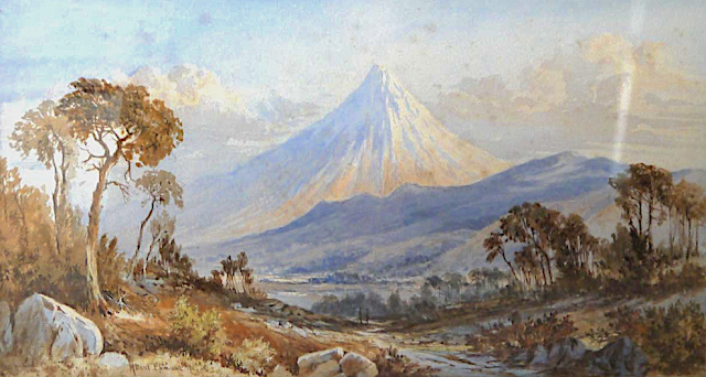
TARANAKI / MOUNT EGMONT PAINTED BY LAURENCE WILLIAM WILSON

https://wanderingvertexes.blogspot.com/2020/12/taranaki-mount-egmont-painted-by.html
 
 
LAURENCE WILLIAM WILSON (1851-1912)
Taranaki /Mount Egmont (2,518 m - 8,261 ft)
New Zealand (Northen Island)

The mountain
Taranaki or Mount Egmont (2,518 m - 8,261 ft) is an active but quiescent stratovolcano in the Taranaki region on the west coast of New Zealand's North Island. Although the mountain is more commonly referred to as Taranaki, it has two official names under the alternative names policy of the New Zealand Geographic Board. The mountain is one of the most symmetrical volcanic cones in the world. There is a secondary cone, Fanthams Peak or Panitahi in Māori (1,966 m - 6,450 ft), on the south side. Because of its resemblance to Mount Fuji, Taranaki provided the backdrop for the movie The Last Samurai.
For many centuries the mountain was called Taranaki by Māori. The Māori word tara means mountain peak, and naki is thought to come from ngaki, meaning "shining", a reference to the snow-clad winter nature of the upper slopes. It was also named Pukehaupapa and Pukeonaki by Iwi who live in the region in ancient times.
According to Māori mythology, Taranaki once resided in the middle of the North Island, with all the other New Zealand volcanoes. The beautiful Pihanga was coveted by all the mountains, and a great battle broke out between them. Tongariro eventually won the day, inflicted great wounds on the side of Taranaki, and causing him to flee. Taranaki headed westwards, following Te Toka a Rahotu and forming the deep gorges of the Whanganui River, paused for a while, creating the depression that formed the Te Ngaere swamp, then heading north. Further progress was blocked by the Pouakai ranges, and as the sun came up Taranaki became petrified in his current location. When Taranaki conceals himself with rainclouds, he is said to be crying for his lost love, and during spectacular sunsets, he is said to be displaying himself to her. In turn, Tongariro's eruptions are said to be a warning to Taranaki not to return.
Captain Cook named it Mount Egmont on 11 January 1770 after John Perceval, 2nd Earl of Egmont, a former First Lord of the Admiralty who had supported the concept of an oceanic search for Terra Australis Incognita. Cook described it as "of a prodigious height and its top cover'd with everlasting snow" surrounded by a "flat country ... which afforded a very good aspect, being clothed with wood and verdure".
When Marc-Joseph Marion du Fresne made landfall off Taranaki on 25 March 1772 he named the mountain Pic Mascarin. He was unaware of Cook's earlier visit. It appeared as Mount Egmont on maps until 29 May 1986, when the Minister of Lands ruled that "Mount Taranaki" would be an alternative and equal official name. The Egmont name still applies to the national park that surrounds the peak and geologists still refer to the peak as the Egmont Volcano.
Taranaki is geologically young, having commenced activity approximately 135,000 years ago. The most recent volcanic activity was the production of a lava dome in the crater and its collapse down the side of the mountain in the 1850s or 1860s. Between 1755 and 1800, an eruption sent a pyroclastic flow down the mountain's northeast flanks, and a moderate ash eruption occurred about 1755, of the size of Ruapehu's activity in 1995/1996. The last major eruption occurred around 1655. Recent research has shown that over the last 9,000 years minor eruptions have occurred roughly every 90 years on average, with major eruptions every 500 years.

The painter
Laurence William Wilson emigrated to Auckland in 1877 and then travelled extensively to settle in Dunedin in 1884. He painted in both oils and watercolours, became a painting companion of George O'Brien and a teacher. One of his pupils was the Dunedin artist Alfred O'Keefe. In 1895, LW Wilson together with Grace Joel, Alfred O'Keefe, Jane Wimperis and Girolami Nerli formed the Easel Club , a breakaway from the Dunedin Establishment, which offered a programme of special classes and the introduction of a professional lady model for life drawing. In 1904 LW Wilson left Dunedin for Melbourne where he spent 5 months on a commissioned painting of the city before he set out for England, eventually returning to New Zealand via India and Africa. He exhibited with the Canterbury Society of Arts in 1882 and the Otago Art Society between 1994 and 1904. His work was included in the NZ and South Seas Exhibition Dunedin 1889-90 and at the St Louis Exposition in 1904. LW Wilson is represented in the collections of all the major public galleries in New Zealand.

___________________________________________

2020 - Wandering Vertexes...
by Francis Rousseau

Tuesday, June 4, 2019

TARANAKI / MT EGMONT PAINTED BY DORIS LUSK


DORIS LUSK (1916-1990) 
Mount Taranaki/ Mount Egmont (2,518 m - 8,261 ft) 
New Zealand (North Island) 

In Mount Egmont from Opunake, oil on board, 60 x 91,5cm, 1956, Private collection

About the painting
This oil Mt Egmont /Taranaki from Opunake was exhibited in the 1956 Group Show as Mt Egmont from Opunake, identifying the painting's location. From Opunake, on the south western side of Mt Taranaki, the distinctive Franthams Peak is clearly visible and recorded in the painting. Consistent with the artist's life-long interest in built structures and the transformation of landscape through habitation, a railway bridge crossing the Taungatara Stream is centrally placed in the composition. Broadly executed, the rounded, rhythmical landforms in the foreground are lahars, the result of lava flows from an ancient volcanic eruption. Touches of pink amongst the rich ochre foreground are gently reflected in the sky on the left. A line of clouds running horizontally across the sky above the mountain emphasise the expansive, tranquil vista. The painting was formerly owned by the artist Tony Fomison, a student and friend of the artist.

The painter
Doris More Lusk was a New Zealand artist and art teacher, potter, university lecturer.  In 1990 she was posthumously awarded the Governor General Art Award in recognition of her artistic career and contributions.
Lusk exhibited mainly with The Group in Christchurch in the 1940s and 1950s.  In the 1950s and 1960s her work was regularly included in the Auckland City Art Gallery's annual surveys of recent New Zealand painting.
Lusk exhibited mainly with The Group in Christchurch in the 1940s and 1950s.
 In the 1950s and 1960s her work was regularly included in the Auckland City Art Gallery's annual surveys of recent New Zealand painting.
The first retrospective exhibition of Lusk's work was held at the Dunedin Public Art Gallery in 1966.A second retrospective was held at the Dowse Art Museum in 1973. A major exhibition of her landscape works, Landmarks: The Landscape Paintings of Doris Lusk, was held at the Christchurch Art Gallery in 1996, accompanied by a publication with contributions by Lisa Beaven and Grant Banbury.
To mark the centenary of Lusk's birth in 1916, in 2016 exhibitions were held at the Dunedin Public Art Gallery (Doris Lusk 1916-1990) and Christchurch Art Gallery (Doris Lusk: Practical Visionary).

The mountain
Taranaki or Mount Egmont (2,518 m - 8,261 ft) is an active but quiescent stratovolcano in the Taranaki region on the west coast of New Zealand's North Island. Although the mountain is more commonly referred to as Taranaki, it has two official names under the alternative names policy of the New Zealand Geographic Board. The mountain is one of the most symmetrical volcanic cones in the world. There is a secondary cone, Fanthams Peak or Panitahi in Māori (1,966 m - 6,450 ft), on the south side. Because of its resemblance to Mount Fuji, Taranaki provided the backdrop for the movie The Last Samurai.
For many centuries the mountain was called Taranaki by Māori. The Māori word tara means mountain peak, and naki is thought to come from ngaki, meaning "shining", a reference to the snow-clad winter nature of the upper slopes. It was also named Pukehaupapa and Pukeonaki by Iwi who live in the region in ancient times.
According to Māori mythology, Taranaki once resided in the middle of the North Island, with all the other New Zealand volcanoes. The beautiful Pihanga was coveted by all the mountains, and a great battle broke out between them. Tongariro eventually won the day, inflicted great wounds on the side of Taranaki, and causing him to flee. Taranaki headed westwards, following Te Toka a Rahotu and forming the deep gorges of the Whanganui River, paused for a while, creating the depression that formed the Te Ngaere swamp, then heading north. Further progress was blocked by the Pouakai ranges, and as the sun came up Taranaki became petrified in his current location. When Taranaki conceals himself with rainclouds, he is said to be crying for his lost love, and during spectacular sunsets, he is said to be displaying himself to her. In turn, Tongariro's eruptions are said to be a warning to Taranaki not to return.
Captain Cook named it Mount Egmont on 11 January 1770 after John Perceval, 2nd Earl of Egmont, a former First Lord of the Admiralty who had supported the concept of an oceanic search for Terra Australis Incognita. Cook described it as "of a prodigious height and its top cover'd with everlasting snow" surrounded by a "flat country ... which afforded a very good aspect, being clothed with wood and verdure".
When Marc-Joseph Marion du Fresne made landfall off Taranaki on 25 March 1772 he named the mountain Pic Mascarin. He was unaware of Cook's earlier visit. It appeared as Mount Egmont on maps until 29 May 1986, when the Minister of Lands ruled that "Mount Taranaki" would be an alternative and equal official name. The Egmont name still applies to the national park that surrounds the peak and geologists still refer to the peak as the Egmont Volcano.
Taranaki is geologically young, having commenced activity approximately 135,000 years ago. The most recent volcanic activity was the production of a lava dome in the crater and its collapse down the side of the mountain in the 1850s or 1860s. Between 1755 and 1800, an eruption sent a pyroclastic flow down the mountain's northeast flanks, and a moderate ash eruption occurred about 1755, of the size of Ruapehu's activity in 1995/1996. The last major eruption occurred around 1655. Recent research has shown that over the last 9,000 years minor eruptions have occurred roughly every 90 years on average, with major eruptions every 500 years.

___________________________________________
2019 - Wandering Vertexes...
by Francis Rousseau 


Tuesday, April 12, 2022

MOUNT TARANAKI / EGMONT SKETCHED BY GEORGINA BURNE HETLEY


GEORGINA BURNE HETLEY (1832-1898) Mount Taranaki/ Mount Egmont (2,518 m - 8,261 ft) New Zealand (North Island)


GEORGINA BURNE HETLEY (1832-1898)
Mount Taranaki/ Mount Egmont (2,518 m - 8,261 ft)
New Zealand (North Island)

In "New Plymouth and Mt Taranaki/Egmont in background ", ink and watercolor,
Alexander Turnbull LIbrary.


The mountain
Taranaki or Mount Egmont (2,518 m - 8,261 ft is an active but quiescent stratovolcano in the Taranaki region on the west coast of New Zealand's North Island. Although the mountain is more commonly referred to as Taranaki, it has two official names under the alternative names policy of the New Zealand Geographic Board. The mountain is one of the most symmetrical volcanic cones in the world. There is a secondary cone, Fanthams Peak or Panitahi in Māori (1,966 m - 6,450 ft), on the south side. Because of its resemblance to Mount Fuji, Taranaki provided the backdrop for the movie The Last Samurai.
For many centuries the mountain was called Taranaki by Māori. The Māori word tara means mountain peak, and naki is thought to come from ngaki, meaning "shining", a reference to the snow-clad winter nature of the upper slopes. It was also named Pukehaupapa and Pukeonaki by Iwi who live in the region in ancient times.
According to Māori mythology, Taranaki once resided in the middle of the North Island, with all the other New Zealand volcanoes. The beautiful Pihanga was coveted by all the mountains, and a great battle broke out between them. Tongariro eventually won the day, inflicted great wounds on the side of Taranaki, and causing him to flee. Taranaki headed westwards, following Te Toka a Rahotu and forming the deep gorges of the Whanganui River, paused for a while, creating the depression that formed the Te Ngaere swamp, then heading north. Further progress was blocked by the Pouakai ranges, and as the sun came up Taranaki became petrified in his current location. When Taranaki conceals himself with rainclouds, he is said to be crying for his lost love, and during spectacular sunsets, he is said to be displaying himself to her. In turn, Tongariro's eruptions are said to be a warning to Taranaki not to return.
Captain Cook named it Mount Egmont on 11 January 1770 after John Perceval, 2nd Earl of Egmont, a former First Lord of the Admiralty who had supported the concept of an oceanic search for Terra Australis Incognita. Cook described it as "of a prodigious height and its top cover'd with everlasting snow" surrounded by a "flat country ... which afforded a very good aspect, being clothed with wood and verdure".
When Marc-Joseph Marion du Fresne made landfall off Taranaki on 25 March 1772 he named the mountain Pic Mascarin. He was unaware of Cook's earlier visit. It appeared as Mount Egmont on maps until 29 May 1986, when the Minister of Lands ruled that "Mount Taranaki" would be an alternative and equal official name. The Egmont name still applies to the national park that surrounds the peak and geologists still refer to the peak as the Egmont Volcano.
Taranaki is geologically young, having commenced activity approximately 135,000 years ago. The most recent volcanic activity was the production of a lava dome in the crater and its collapse down the side of the mountain in the 1850s or 1860s. Between 1755 and 1800, an eruption sent a pyroclastic flow down the mountain's northeast flanks, and a moderate ash eruption occurred about 1755, of the size of Ruapehu's activity in 1995/1996. The last major eruption occurred around 1655. Recent research has shown that over the last 9,000 years minor eruptions have occurred roughly every 90 years on average, with major eruptions every 500 years.

The Artist
Georgina Burne Hetley was a New Zealand artist and writer. Her book The Native Flora of New Zealand was published in English and French. Hetley was born in Battersea, Surrey, England on 27 May 1832. The family moved to Madeira, Portugal when Hetley was around 10 years old, leaving in 1852 for New Zealand when her father died. Annette McKellar, her children and two servants arrived in New Plymouth on the St Michael in December 1853.  Annette McKellar bought a block of about fifty acres of land at Omata, six miles south of New Plymouth. She called their farm Fernlea.  Hetley subsequently married a fellow settler Charles Hetley in the Omata church on 2 June 1856 and moved to Brookwood farm. Just prior to their first wedding anniversary Charles died, leaving Hetley with a newborn son, Charles Frederick Hetley.  This led to Hetley selling her farm two years later and returning to Fernlea to live with her mother. Hetley lived in Taranaki until 1860 when the First Taranaki War broke out.  The conflict led to Annette McKellar moving her family to New Plymouth. Fernlea was burnt down in the ensuing conflict, although the family rebuilt it later.  While in Taranaki, Hetley began drawing sketches and watercolours of the farm and surrounding landscapes. She continued this practice after the move to New Plymouth, painting the urban scenes in New Plymouth, Waikato and Auckland. Between 1863 and the late 1870s, she travelled to Queensland and sketched local stations.  She and her son moved to Auckland by 1879.  Hetley went to England to seek a publisher, receiving assistance along the way from authorities at Kew, and the chromolithographs were ultimately produced in 1888 by Leighton Brothers. The plates also had the distinction of being published in a French edition a year later.  Without the work of botanical artists such as Hetley there would be no record of what this plant truly looked like.  While in London, her work was exhibited at the Colonial and Indian Exhibition.  Hetley returned to New Zealand in 1889 and exhibited her New Zealand flora at the General Assembly Library in Wellington. She also held another major exhibit, 150 paintings in all, at Auckland Museum. Hetley lived in Auckland for the rest of her life, dying there after a long illness, on 29 August 1898.
In 2017, Hetley was selected as one of the Royal Society Te Apārangi's "150 women in 150 words", celebrating the contributions of women to knowledge in New Zealand.

___________________________________________
2022 - Wandering Vertexes...
by Francis Rousseau

Tuesday, August 1, 2017

TARANAKI / MOUNT EGMONT BY CHARLES BLOMFIELD


CHARLES BLOMFIELD (1848-1926)
Mount Taranaki or Mount Egmont  (2,518 m - 8,261 ft) 
New Zealand (North Island) 

1. In Mount Egmont from the Waterworks, 1880, oil on canvas, 

The mountain 
Taranaki or Mount Egmont  (2,518 m - 8,261 ft) is an active but quiescent stratovolcano in the Taranaki region on the west coast of New Zealand's North Island. Although the mountain is more commonly referred to as Taranaki, it has two official names under the alternative names policy of the New Zealand Geographic Board. The mountain is one of the most symmetrical volcanic cones in the world. There is a secondary cone, Fanthams Peak or Panitahi in Māori (1,966 me - 6,450 ft), on the south side.  Because of its resemblance to Mount Fuji, Taranaki provided the backdrop for the movie The Last Samurai.
For many centuries the mountain was called Taranaki by Māori. The Māori word tara means mountain peak, and naki is thought to come from ngaki, meaning "shining", a reference to the snow-clad winter nature of the upper slopes. It was also named Pukehaupapa and Pukeonaki by Iwi who live in the region in ancient times.
According to Māori mythology, Taranaki once resided in the middle of the North Island, with all the other New Zealand volcanoes. The beautiful Pihanga was coveted by all the mountains, and a great battle broke out between them. Tongariro eventually won the day, inflicted great wounds on the side of Taranaki, and causing him to flee. Taranaki headed westwards, following Te Toka a Rahotu and forming the deep gorges of the Whanganui River, paused for a while, creating the depression that formed the Te Ngaere swamp, then heading north. Further progress was blocked by the Pouakai ranges, and as the sun came up Taranaki became petrified in his current location. When Taranaki conceals himself with rainclouds, he is said to be crying for his lost love, and during spectacular sunsets, he is said to be displaying himself to her. In turn, Tongariro's eruptions are said to be a warning to Taranaki not to return.
Captain Cook named it Mount Egmont on 11 January 1770 after John Perceval, 2nd Earl of Egmont, a former First Lord of the Admiralty who had supported the concept of an oceanic search for Terra Australis Incognita. Cook described it as "of a prodigious height and its top cover'd with everlasting snow" surrounded by a "flat country ... which afforded a very good aspect, being clothed with wood and verdure".
When Marc-Joseph Marion du Fresne made landfall off Taranaki on 25 March 1772 he named the mountain Pic Mascarin. He was unaware of Cook's earlier visit.  It appeared as Mount Egmont on maps until 29 May 1986, when the Minister of Lands ruled that "Mount Taranaki" would be an alternative and equal official name. The Egmont name still applies to the national park that surrounds the peak and geologists still refer to the peak as the Egmont Volcano.
Taranaki is geologically young, having commenced activity approximately 135,000 years ago. The most recent volcanic activity was the production of a lava dome in the crater and its collapse down the side of the mountain in the 1850s or 1860s. Between 1755 and 1800, an eruption sent a pyroclastic flow down the mountain's northeast flanks, and a moderate ash eruption occurred about 1755, of the size of Ruapehu's activity in 1995/1996. The last major eruption occurred around 1655. Recent research has shown that over the last 9,000 years minor eruptions have occurred roughly every 90 years on average, with major eruptions every 500 years.

The painter 
 Charles Blomfield  was a New Zealand decorator, artist and music teacher born in London, England.
A widow, Blomfield's mother brought her family to New Zealand in the 1860's intending to settle in Northland as part of a settlement called Albertland. On arrival in Auckland they decided not to proceed on Northland to become farmers but to pursue urban trades in Auckland. The family remained in Auckland after that and many of the descendants of the various children still reside in the Auckland area.
Charles Blomfield lived in Freeman's Bay - 40 Wood Street, in a house built by his brother and allegedly made out of the timber from one large Kauri tree. As well as an exhibiting easel painter Blomfield worked as a sign-writer and interior decorator; for this trade he maintained studios in shops at various times. These were usually on Karangahape Road, one of these was shared with his daughter who made a living painting floral pieces which she also exhibited at the Auckland Society of Arts.
Blomfield travelled throughout the centre of the North Island on several occasions in the 1870s and 80s creating many landscape paintings of the New Zealand countryside, often for sale to visitors to New Zealand. He was fortunate to view the famed Pink and White Terraces several times and paint them before they were destroyed by the eruption of Tarawera in 1886. His meticulous sketches and finished paintings are some of the main records of them (see above).  For the remainder of his life he was probably able to rely on new versions of his classic views of them to supplement his income.
His paintings are widely regarded as the epitome of 19th century New Zealand landscape art, although his work, like many of his contemporaries, fell out of fashion during the 20th century, only to be re-evaluated in the 1970s. He was unable to come to terms with developments in art and remained staunchly conservative and hostile to 'modern art'. In his later years he found himself increasingly sidelined by the artistic circles in Auckland which he had previously shone in and was probably embittered by this.
Blomfield died at his residence in Wood Street in 1926. He was survived by several children. One of his brothers, William, was a noted newspaper cartoonist.
 Source : 

Tuesday, October 9, 2018

TARANAKI / MOUNT EGMONT BY JOHN BARR CLARK HOYTE


http://wanderingvertexes.blogspot.com


JOHN BARR CLARK HOYTE (1835-1913)
Mount Taranaki / Mount Egmont  (2,518 m - 8,261 ft) 
New Zealand (North Island) 

In  Mount Egmont, Taranaki, watercolor  Alexander Turnbull Library 


The mountain 
Taranaki / Mount Egmont  (2,518 m - 8,261 ft) is an active but quiescent stratovolcano in the Taranaki region on the west coast of New Zealand's North Island.
According to Māori mythology, Taranaki once resided in the middle of the North Island, with all the other New Zealand volcanoes. The beautiful Pihanga was coveted by all the mountains, and a great battle broke out between them. Tongariro eventually won the day, inflicted great wounds on the side of Taranaki, and causing him to flee. Taranaki headed westwards, following Te Toka a Rahotu and forming the deep gorges of the Whanganui River, paused for a while, creating the depression that formed the Te Ngaere swamp, then heading north. Further progress was blocked by the Pouakai ranges, and as the sun came up Taranaki became petrified in his current location. When Taranaki conceals himself with rainclouds, he is said to be crying for his lost love, and during spectacular sunsets, he is said to be displaying himself to her. In turn, Tongariro's eruptions are said to be a warning to Taranaki not to return.
Captain Cook named it Mount Egmont on 11 January 1770 after John Perceval, 2nd Earl of Egmont, a former First Lord of the Admiralty who had supported the concept of an oceanic search for Terra Australis Incognita. Cook described it as "of a prodigious height and its top cover'd with everlasting snow" surrounded by a "flat country ... which afforded a very good aspect, being clothed with wood and verdure".

The Painter 
John Barr Clark Hoyte was born in England, probably in London,  Nothing is known of Hoyte's education and artistic training and we are reduced to the obvious deduction that he was heir to the English tradition of topographic draughtsmanship and watercolour painting. Firm drawing underlies his landscapes, making it appropriate to group him with colonial surveyor–architect artists such as Edward Ashworth, Edmund Norman and George O'Brien.
During his years in New Zealand John Hoyte travelled assiduously in search of new scenes to exploit.   His pictorial exploration of the colony's principal dramatic landscapes was completed when he took a cruise circumnavigating the South Island in early 1877, exploring the coast of Fiordland with particular attention. New Zealand subjects would continue to inspire his production long after he had settled in Australia, where they shared his attention with coastal and mountain views drawn chiefly from the neighbourhood of Sydney.
Despite his apparent commercial success, however, Hoyte's standing, like that of George O'Brien, waned in the 1870s: a decade which marked a major shift in New Zealand colonial taste as the Turnerian Romantics such as Gully, J. C. Richmond and W. M. Hodgkins moved into greater prominence. They and their style were to dominate the following decades.

2018 - Wandering Vertexes...
by Francis Rousseau 

Sunday, January 13, 2019

TARANAKI / MT EGMONT BY SIR WILLIAM FOX


SIR WILLIAM FOX (1812-1893)
Taranaki / Mount Egmont  (2,518 m - 8,261 ft) 
New Zealand  (North Island) 

 In Mount Egmont from the coast, watercolor, 1860, Alexander Turnbull Library

The mountain 
Taranaki / Mount Egmont  (2,518 m - 8,261 ft) is an active but quiescent stratovolcano in the Taranaki region on the west coast of New Zealand's North Island.
According to Māori mythology, Taranaki once resided in the middle of the North Island, with all the other New Zealand volcanoes. The beautiful Pihanga was coveted by all the mountains, and a great battle broke out between them. Tongariro eventually won the day, inflicted great wounds on the side of Taranaki, and causing him to flee. Taranaki headed westwards, following Te Toka a Rahotu and forming the deep gorges of the Whanganui River, paused for a while, creating the depression that formed the Te Ngaere swamp, then heading north. Further progress was blocked by the Pouakai ranges, and as the sun came up Taranaki became petrified in his current location. When Taranaki conceals himself with rainclouds, he is said to be crying for his lost love, and during spectacular sunsets, he is said to be displaying himself to her. In turn, Tongariro's eruptions are said to be a warning to Taranaki not to return.
Captain Cook named it Mount Egmont on 11 January 1770 after John Perceval, 2nd Earl of Egmont, a former First Lord of the Admiralty who had supported the concept of an oceanic search for Terra Australis Incognita. Cook described it as "of a prodigious height and its top cover'd with everlasting snow" surrounded by a "flat country ... which afforded a very good aspect, being clothed with wood and verdure".

The artist 
Sir William Fox was the second Premier of New Zealand and held that office on four separate occasions in the 19th century, while New Zealand was still a colony. He was known for his confiscation of Māori land rights, his contributions to the education system (such as establishing the University of New Zealand), and his work to increase New Zealand's autonomy from Britain. He has been described as determined and intelligent, but also as bitter and "too fond" of personal attacks. Different aspects of his personality are emphasised by different accounts, changing mainly due to the reviewers' political beliefs. HU use to be a  "amateur "watercolourist as well.
_______________________________

2019 - Wandering Vertexes...
by Francis Rousseau 

Monday, January 20, 2020

TARANAKI / MOUNT EGMONT BY CHARLES DECIMUS BARRAUD


CHARLES DECIMUS BARRAUD (1822-1897)
Mount Taranaki or Mount Egmont  (2,518 m - 8,261 ft) 
New Zealand (North Island)

In Mount Egmont Taranaki,  watercolour, 1870, Alexander Turnbull Library, New Zealand

The mountain
Taranaki or Mount Egmont (2,518 m - 8,261 ft) is an active but quiescent stratovolcano in the Taranaki region on the west coast of New Zealand's North Island. Although the mountain is more commonly referred to as Taranaki, it has two official names under the alternative names policy of the New Zealand Geographic Board. The mountain is one of the most symmetrical volcanic cones in the world. There is a secondary cone, Fanthams Peak or Panitahi in Māori (1,966 me - 6,450 ft), on the south side.
 For many centuries the mountain was called Taranaki by Māori. The Māori word tara means mountain peak, and naki is thought to come from ngaki, meaning "shining", a reference to the snow-clad winter nature of the upper slopes. It was also named Pukehaupapa and Pukeonaki by Iwi who live in the region in ancient times.
According to Māori mythology, Taranaki once resided in the middle of the North Island, with all the other New Zealand volcanoes. The beautiful Pihanga was coveted by all the mountains, and a great battle broke out between them. Tongariro eventually won the day, inflicted great wounds on the side of Taranaki, and causing him to flee. Taranaki headed westwards, following Te Toka a Rahotu and forming the deep gorges of the Whanganui River, paused for a while, creating the depression that formed the Te Ngaere swamp, then heading north. Further progress was blocked by the Pouakai ranges, and as the sun came up Taranaki became petrified in his current location. When Taranaki conceals himself with rainclouds, he is said to be crying for his lost love, and during spectacular sunsets, he is said to be displaying himself to her. In turn, Tongariro's eruptions are said to be a warning to Taranaki not to return....

The artist
Charles Decimus Barraud was born in Camberwell, London, England. he wanted to become a doctor, but his father, a clerk in the Custom House,  died when Charles was only 11 years old and his family could not afford the expensive training. He had to content himself with qualifying as a chemist and druggist.
Long Biography 

__________________________________

2020 - Wandering Vertexes...
by Francis Rousseau


Sunday, May 3, 2020

TARANAKI / MOUNT EGMONT( 2) BY CHARLES BLOMFIELD

http://wanderingvertexes.blogspot.com 
CHARLES BLOMFIELD (1848-1926)
Taranaki /Mount Egmont (2,518 m - 8,261 ft)
New Zealand (North Island)

In Mont Egmont, 1880, oil on canvas, Museum of New Zealand  /Te Papa Tongarewa

The mountain
Taranaki or Mount Egmont (2,518 m - 8,261 ft) is an active but quiescent stratovolcano in the Taranaki region on the west coast of New Zealand's North Island. Although the mountain is more commonly referred to as Taranaki, it has two official names under the alternative names policy of the New Zealand Geographic Board. The mountain is one of the most symmetrical volcanic cones in the world. There is a secondary cone, Fanthams Peak or Panitahi in Māori (1,966 me - 6,450 ft), on the south side. Because of its resemblance to Mount Fuji, Taranaki provided the backdrop for the movie The Last Samurai.
More about the mountain

The painter
Charles Blomfield was a New Zealand decorator, artist and music teacher born in London, England.
A widow, Blomfield's mother brought her family to New Zealand in the 1860's intending to settle in Northland as part of a settlement called Albertland. On arrival in Auckland they decided not to proceed on Northland to become farmers but to pursue urban trades in Auckland. The family remained in Auckland after that and many of the descendants of the various children still reside in the Auckland area.
More about the painter 

_________________________________________

2020 - Wandering Vertexes...
by Francis Rousseau

Tuesday, January 2, 2018

MT ARTHUR/ TUAO WHAREPAPA BY JOHN BARR CLARK HOYTE


JOHN BARR CLARK HOYTE (1835-1913) 
Mount Arthur / Tuao Wharepapa  (1,795 m- 5,889 ft) 
New Zealand (South Island) 

 In Mt Arhur New Zealand, watercolour, 1877

The mountain
Mount Arthur / Tuao Wharepapa  (1,795m- 5,889ft) is in the Arthur Range in the north western area of the South Island of New Zealand, within Kahurangi National Park. Mount Arthur is named after Captain Arthur Wakefield. Mt Arthur is made of hard, crystalline marble, transformed from limestone, originally laid down under the sea some 450 million years ago. Below ground are some of the deepest shafts and most intricate cave systems in the country, and exploration of these is far from finished. Mount Arthur is home to the Ellis Basin cave system, the deepest cave in the Southern Hemisphere, and Nettlebed Cave which was thought to be the deepest cave system the Southern Hemisphere prior to discovery of the Ellis Basin cave system in 2010. During the ice ages small glaciers carved smooth basins called 'cirques' high on Mt Arthur, polishing and scraping the tough marble. The floors of the cirques are studded with sinkholes where surface water is taken underground into extensive cave systems.

The painter 
John Barr Clark Hoyte was born in England, probably in London,  the son of Samuel Hoyte, a landowner. His mother's name is not known, nor are any details of his childhood. From 1856 to 1859 he was employed as a planter in Demerara, Guyana, after which he returned to England. On 1860, at Leamington, Warwickshire, he married Rose Esther Elizabeth Parsons, daughter of an iron merchant. Within three months they sailed on the Egmont for Auckland, New Zealand, where they were to live for 16 years. Three daughters were born in Auckland, and the couple may also have had a son. A brother of John Hoyte emigrated to New Zealand, possibly in the 1870s.
Nothing is known of Hoyte's education and artistic training and we are reduced to the obvious deduction that he was heir to the English tradition of topographic draughtsmanship and watercolour painting. Firm drawing underlies his landscapes, making it appropriate to group him with colonial surveyor–architect artists such as Edward Ashworth, Edmund Norman and George O'Brien.
During his years in New Zealand John Hoyte travelled assiduously in search of new scenes to exploit. In January 1866 he exhibited views from Whangarei, Coromandel, Auckland, Waikato, the Wellington region and Nelson, although some of these pictures were not painted from the subject. In the 1870s he travelled each summer, progressively adding the thermal region, Taranaki, Nelson, Christchurch, Arthur's Pass, Banks Peninsula and Otago to his repertoire between 1872 and 1876.
His pictorial exploration of the colony's principal dramatic landscapes was completed when he took a cruise circumnavigating the South Island in early 1877, exploring the coast of Fiordland with particular attention. New Zealand subjects would continue to inspire his production long after he had settled in Australia, where they shared his attention with coastal and mountain views drawn chiefly from the neighbourhood of Sydney.
The success of the art unions of his work shows that the subjects he painted were in harmony with public taste. Despite the exceptional landscapes which appear so frequently in his production – geysers, the Pink and White Terraces, fiords, mountains and lakes – it appears that his preference was for a more gentle, picturesque mode of landscape art rather than the heightened tensions of the sublime. The Otago Guardian in 1876 described 'the aspect of repose which usually characterises Mr Hoyte's illustrations of native landscapes'. A comparison of Fiordland subjects painted by Hoyte and John Gully shows that Hoyte eschewed the manipulation of the viewer's emotions which the latter exploited so regularly. Even in his pastoral subjects Gully could be relied on to introduce an epic element which Hoyte usually avoided. Despite his apparent commercial success, however, Hoyte's standing, like that of George O'Brien, waned in the 1870s: a decade which marked a major shift in New Zealand colonial taste as the Turnerian Romantics such as Gully, J. C. Richmond and W. M. Hodgkins moved into greater prominence. They and their style were to dominate the following decades.

Saturday, December 24, 2022

LE MONT SINAÏ PEINT PAR PIETER BRUEGEL L'ANCIEN 


PIETER BRUEGEL L'ANCIEN (1525-1569) Mount Sinaï / Jabal Musa (2,285 m - 7,496ft) Egypt  In "Paysage avec La Fuite en Egypte", huile sur panneau , 1563, 37.1 × 55.6 cm, Courtauld Institute of Art, London

PIETER BRUEGEL L'ANCIEN (1525-1569)
Mount Sinaï / Jabal Musa (2,285 m - 7,496ft)
Egypte

In "Paysage avec La Fuite en Egypte", huile sur panneau , 1563, 37.1 × 55.6 cm, Courtauld Institute of Art, London 

A propos de ce tableau
Il s 'agit bien entendu d'une représentation imaginaire du Mont Sinai, Breughel comme tous les autres peintres de son temps s'inspirant des récits de voyageurs ou de témoignages de pèlerins pour en dresser la silhouette. D'où certaines erreurs. Ici la plus flagrante est la présence de l'eau. De beaucoup d'eau ! Beaucoup trop  d'eau lorsqu'on sait que c'est plutôt un désert aride qui entoure le Mont Sinaï. Mais la montagne elle-même (à gauche de la composition) est décrite avec un certain réalisme, ses  célèbres trois sommets y sont et la physionomie générale n'est pas très éloignée de ce que l'on peut observer dans la réalité.

La montagne
Le mont Sinaï (2 285 m - 7 496 ft) ou Jabal Mūsā ou Gabal Mūsā (en arabe : "Montagne de Moïse" ou "Mont Moïse"), également connu sous le nom de Mont Horeb ou Jebel Musa (une montagne du même nom au Maroc), est une montagne dans la péninsule du Sinaï en Égypte. Elle est considérée comme l'emplacement le plus probable du mont Sinaï ,la montagne sacrée décrite dans la Bible.  Ce dernier est mentionné à plusieurs reprises dans le Livre de l'Exode (et d'autres livres de la Bible) ainsi que dans  le Coran. Selon la tradition juive, chrétienne et islamique, le mont Sinaï est le lieu où Moïse a reçu les Dix Commandements, les Tables de la Loi.
Le mont Sinaï est une montagne modérément élevée près de la ville de Saint Katherine dans la région du Sinaï. Il est situé juste à côté du mont Katherine (2 629 m - 8 625 pieds), le plus haut sommet d'Égypte.
Les roches du mont Sinaï se sont formées à la fin de l'évolution du bouclier arabo-nubien (ANS). Le mont Sinaï présente un complexe annulaire composé de granites alcalins pénétrés dans divers types de roches, y compris des roches volcaniques. Les granites varient en composition du syénogranite au granit de feldspath alcalin. Les roches volcaniques sont alcalines à hyperalcalines et elles sont représentées par des coulées et des éruptions subaériennes et du porphyre subvolcanique. En général, la nature des roches exposées du mont Sinaï indique qu'elles proviennent de profondeurs différentes.
Il y a deux routes principales vers le sommet. La route la plus longue et la moins profonde, Siket El Bashait, prend environ 2, heures et demi à pied, bien que des chameaux puissent être utilisés. La route la plus raide et la plus directe (Siket Sayidna Musa) monte les 3 750 "marches de pénitence" dans le ravin derrière le monastère.
Le sommet de la montagne comporte  une mosquée qui est encore utilisée par les musulmans. Il possède également une chapelle orthodoxe grecque, construite en 1934 sur les ruines d'une église du 16e siècle, qui n'est pas ouverte au public. La chapelle renferme le rocher qui est considéré comme l'endroit où furent remise à Moïse, les Tables de la Loi. Au sommet se trouve également la "Grotte de Moïse", où Moïse aurait attendu avant de  recevoir les Dix Commandements.

Le peintre
Pieter Brueghel ou Bruegel dit l'Ancien, parfois francisé en Pierre Brueghel l'Ancien (est un peintre et graveur brabançon né vers 1525 et mort le 9 septembre 1569 à Bruxelles dans les Pays-Bas espagnols.
Avec Jan van Eyck, Jérôme Bosch et Pierre Paul Rubens, il est considéré comme l'une des grandes figures de l'École flamande, et l'une des principales de l'École d'Anvers. oujours selon van Mander, il fut l'élève de Pieter Coecke van Aelst, artiste cultivé, doyen de la guilde des artistes, à la fois peintre et architecte. En 1552, il fait un voyage en Italie, résidant à Rome où il a pu travailler avec le miniaturiste Giulio Clovio. Le Port de Naples, le décor de La Chute d'Icare et du Suicide de Saül ainsi que quelques dessins témoignent de son périple. Il est vraisemblable que Brueghel ait prolongé son voyage plus au Sud. À l'arrière plan du Combat naval dans le détroit de Messine, certains ont reconnu le village de Reggio di Calabria, face à la Sicile.
Entre 1555 et 1563, il est établi à Anvers et travaille pour l'éditeur Jérôme Cock, réalisant des dessins préliminaires pour des séries d'estampes.
À Anvers, il fréquente un cercle d'artistes et d'érudits humanistes, notamment le mécène Niclaes Jonghelinck qui possédait seize de ses œuvres. Il fut aussi l'ami du cartographe Abraham Orteliusqui écrivit quelques lignes émouvantes à sa mémoire14. Mais sa vie sociale déborde largement de ce milieu intellectuel. Il fréquente volontiers les noces paysannes auxquelles il se fait inviter comme « parent ou compatriote » des époux.
En 1562, à la demande de sa future belle-mère , il s'installe à Bruxelles dans le quartier des Marolles au 132, rue Haute, dans une maison à pignons à gradins de style médiéval flamand typique du 16e siècle. C'est à l'église Notre-Dame de la Chapelle qu'il épouse en 1563 Mayken Coecke, fille de son maître Pieter Coecke van Aelst et de Mayken Verhulst. Une étude de l'archiviste Jean Bastiaensen montre que le peintre résidait 16 rue des Bogards en face du couvent éponyme. À l'époque de la Réforme, les Calvinistes se réunirent en 1579 en la maison appelée "Schavershuyse", située en face de l'église des Bogards. Trois maisons classées de la rue de la Gouttière donnent une idée du bâti de l’époque. Un vestige de la chapelle construite en 1718 se trouve inséré dans les bâtiments de l'Académie royale des beaux-arts de Bruxelles. La rue des Bogards relevait de la paroisse de l'église Notre-Dame de la Chapelle.
En 1564 naît le premier de ses fils, Pieter Brueghel le Jeune, dit Bruegel d'Enfer. La situation politique et religieuse en Flandres se dégrade. En 1567 le duc d'Albe entreprend une campagne de répression sanglante contre les rebelles, et c'est l'année même de l'exécution des comtes d'Egmont et de Horn que naît en 1568 son second fils, Jan Brueghel l'Ancien, dit Brueghel de Velours. Il semble certain que Pieter Brueghel l'Ancien ait reçu la protection du gouverneur des Pays-Bas espagnols, Antoine Perrenot de Granvelle, collectionneur de ses œuvres.

 _________________________________________

2022 - Wandering Vertexes ....
            Errant au-dessus des Sommets Silencieux...
            Un blog de Francis Rousseau