google.com, pub-0288379932320714, DIRECT, f08c47fec0942fa0 GRAVIR LES MONTAGNES... EN PEINTURE: VINTAGE PRINTS
Showing posts with label VINTAGE PRINTS. Show all posts

Tuesday, July 5, 2022

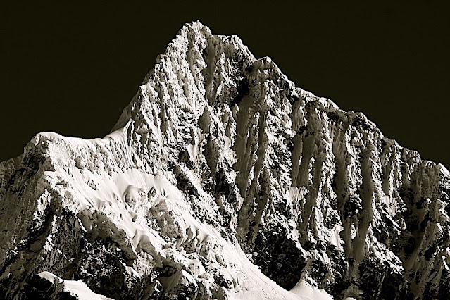
ALPAMAYO SUMMIT PHOTOGRAPHED IN 1936 BY ERWIN SCHNEIDER


ERWIN SCHNEIDER (1906-1987) Alpamayo ( 5,947m - 19,511 ft) Peru  In  "Alpamayo summit", argentic photo 1936 
 
 
ERWIN SCHNEIDER (1906-1987) 
Alpamayo ( 5,947m - 19,511 ft) 
Peru

In  "Alpamayo summit", argentic photo 1936


The mountain

Alpamayo ( 5,947m - 19,511 ft) possibly named from Quechua words is one of the most conspicuous peaks in the Cordillera Blanca of the Peruvian Andes. Alpamayo Creek originates northwest of it. The Alpamayo lies next to the slightly higher Quitaraju. n July 1966, the German magazine "Alpinismus", published a photo of Alpamayo taken by American photographer Leigh Ortenburger accompanied by an article on a survey among mountaineering experts, who chose Alpamayo as "The Most Beautiful Mountain in the World". Not defined by a single summit Alpamayo has two sharp summits, the North and south, which are separated by a narrow corniced ridge.
The first attempt on Alpamayo's summit was in 1948 by a Swiss expedition. Climbing by way of the heavily corniced North Ridge, the three climbers came within sight of the virgin summit when a large cornice broke under them and they were carried down the precipitous Northwest Face. By some amazing piece of good fortune, the three were neither buried nor injured by the 650 foot fall and they were able to make an 'orderly retreat' from the mountain. In 1951, a Franco-Belgian expedition including George and Claude Kogan claimed to have made the first ascent via the North Ridge. After studying the photos in George Kogan's book The Ascent of Alpamayo, the German team of Günter Hauser, Frieder Knauss, Bernhard Huhn and Horst Wiedmann came to the conclusion that the 1951 team did not reach the actual summit, thereby making their ascent via the South Ridge in 1957 the first. Although the South Ridge is no less steep or dangerous than the North Ridge, it has the advantage of leading directly to the higher south summit. This was written up in Hauser's book White Mountain and Tawny Plain. Although there are several climbing routes on the Southwest Face the most common is known as the Ferrari or Italian Route. It was opened in 1975 by a group of Italian alpinists led by Casimiro Ferrari. It begins at the top of the highest point of the snow slope where the bergshrund separates the upper face on the left and then ascends a steep runnel to the summit ridge. Because of its esthetic beauty, Alpamayo is one of the most climbed mountains in the Andes and the base camp can be a hodge-podge of nationalities. Each year the route is made easy by the first party to ascend the route as they usually leave snow-stakes in place at the belay stations. Then it is just a matter of finding out what length of rope they used so that your rope is long enough to reach each station. In the summer of 1988, they had used 50m ropes.

The photographer
Erwin Hermann Manfred Schneider was an Austrian mountaineer. On July 25, 1928, he was part of the German-Soviet expedition for the first ascent of Lenin Peak. They reach the top with Karl Wien and Eugen Allwein. In 1930, he participated in an expedition in the Himalayas led by Günter Dyhrenfurth to Kangchenjunga. On June 21, 1931, he made the first ascent of Jongsong Peak at 7,462 meters1,2. They climb the Ramthang Chang at 6,802 meters. In 1932 and 1936, he took part in two expeditions organized by the German-Austrian Alpine Club (DuOeAV). During these expeditions, Schneider and his companions made about ten first ascents.

___________________________________________
2022 - Wandering Vertexes...
by Francis Rousseau
Saturday, February 24, 2018

NEVADO HUASCARAN IN VINTAGE PRINTS 1908 & 1960


VINTAGE PRINTS 1908  & 1960
Nevado Huascaràn  (6,778m - 22,205ft) 
Peru 

1.  In The american alpinist Annie Smith Peck at the summit of Husacaràn Norte with Huascaràn Sur behind her, Archive photo,  September 2, 1908    
2.  In  Nevado Huascaran (Norte and Sur) seen from the Village Yungay, destroyed by an avalanche in 1970, Archive photo, 1960


The mountain 
Nevado Huascaràn is a mountain in the Peruvian province of Yungay, situated in the Cordillera Blanca range of the western Andes.  Nevado Huascaràn  is the highest point in Peru, the northern part of Andes (north of Lake Titicaca) and in all of the Earth's Tropics. Huascaràn is the fourth highest mountain in the Western Hemisphere and South America after Aconcagua, Ojos del Salado, and Monte Pissis.
The mountain has two distinct summits, the higher being the south one, Huascaran Sur (6,768 m-  -22,205 ft). and the north summit, Huascaran Norte (6, 654m - 21, 831ft). The core of Huascarбn, like much of the Cordillera Blanca, consists of Cenozoic era granite.
Huascaran gives its name to Huascaran National Park which surrounds it, and is a popular location for trekking and mountaineering. The Huascaran summit is one of the points on the Earth's surface farthest from the Earth's center, closely behind the farthest point, Chimborazo in Ecuador.
The mountain was named after Huбscar, a 16th-century Inca emperor who was the Sapa Inca of the Inca empire.
The summit of Huascaran is the place on Earth with the smallest gravitational force.
Climbing
The north peak (Huascaran Norte) had been first climbed on 2 September 1908 by a U.S. expedition that included Annie Smith Peck, albeit this first ascent is somewhat disputed
The summit of Huascaran Sur was first reached on 20 July 1932 by a joint German–Austrian expedition. The team followed what would become later the normal route (named today Garganta route).
On 31 May 1970, the Ancash earthquake caused a substantial part of the north side of the mountain to collapse. The avalanche mass, an estimated 80 million cubic metres (2.8 billion cubic feet) of ice, mud and rock, was about half a mile wide and a mile long. It advanced about 11 miles (18 km) at an average speed of 280 to 335 km/h (175 to 210 mph), burying the towns of Yungay  (in the second photo above) and Ranrahirca under ice and rock, killing more than 20,000 people. At least 20,000 people were also killed in Huaraz, site of a 1941 avalanche which killed over 6000 (see Palcacocha Lake). Estimates suggest that the earthquake killed over 66,000 people.
In 1989, a group of eight amateur mountaineers, the "Social Climbers", held what was recognised by the Guinness Book of Records (1990 edition) to be "the world's highest dinner party" on top of the mountain, as documented by Chris Darwin and John Amy in their book The Social Climbers, and raised Ј10,000 for charity.
Climbing Huascaran's has become increasingly dangerous due to climate change. On July 20, 2016, nine climbers were caught in an avalanche on Huascaran's normal route at approximately 5,800 m (19,000 ft), four of whom died.

Wednesday, February 21, 2018

MOUNT WILLIAM (ANTARCTICA) IN VINTAGE PRINTS 1898


VINTAGE PRINTS  1898
Mount William (1,600m - 6,200 ft) 
Antarctica 

In  Le Belgica ancré devant le Mont William 1898,
From Travaux hydrographiques et Instructions Nautiques  by Georges Lecointe

The mountain
Mount William (1,600m - 6,200 ft)  is a prominent snowy mountain in Antarctica,  located 6 kilometres (3.7 mi) north-northeast of Cape Lancaster which is the south extremity of Anvers Island, in the Palmer Archipelago. This is the tallest mountain visible from Biscoe Bay, near the south end of the island's Osterrieth Range which also includes Mount Français (the tallest mountain on the island).
This mountain was discovered on February 21, 1832, by John Biscoe who incorrectly believed it to be part of the mainland of Antarctic Peninsula, instead of on an island. He named it for William IV, then King of the United Kingdom. Mountain climbers from the U.K. were the first to ascend this peak, in 1956. In 2003, after climbing this mountain, two Americans skied down.

About the Belgica expedition 
The Belgian Antarctic Expedition led by Adrien de Gerlache de Gomery from 1897 to 1899 aboard the Belgica, is the first expedition to winter in the Antarctic region and, most of all, the very expedition to Antartica.  Among its members are Frederick Cook and Roald Amundsen, explorers who will claim, respectively, the conquest of the North Pole and the conquest of the South Pole and the Northwest Passage.
First expedition to Antarctica with purely scientific objectives, she left Antwerp on August 16, 1897 and headed for the west coast of the Antarctic Peninsula.  Even before the arrival to the South, several members of the crew abandon the ship or are caught in various quarrels and incidents in Ostend, Montevideo and Punta Arenas, leaving doubts about the choice and quality of the crew members compared to the scientific staff who are irreproachable.  The different nationalities and languages ​​associated with discipline problems undermine the morale of the crew.
After a long journey, the crew docked in Tierra del Fuego or they will have the last contacts with men before their departure to the great south.
Their arrival on the Antarctic continent is the occasion of the first scientific discoveries on these lands. A team of international scientists including a biologist, a glaciologist, a geographer, a naturalist and a doctor will work for several weeks to collect as much information as possible about these virgin lands.
Despite the season, it is decided to continue the exploration further south ..., the ship will be trapped by ice a few weeks later near the island Peter I, and will drift into the sea Bellingshausen during the following thirteen months. The expedition thus became the first to officially winter in the Antarctic region. Seal hunters had forcibly wintered on King George Island in the South Shetland Islands in 1821.
The members of the expedition lived in very harsh weather conditions, but this will not prevent them from collecting a significant amount of scientific data and commenting on the annual Antarctic cycle1. The crew is severely affected by scurvy, but Dr. Cook, in advising the seal and penguin meat, will restore the members of the expedition. On July 5, 1898, Émile Danco died of a heart attack.
After months of drifting, the ship managed to free itself from the ice and make its way to Belgium where explorers were welcomed as heroes. 
This first scientific expedition will launch the great nations to discover the continent. The Belgica Expedition will go down in history as the pioneering expedition to scientific research in Antarctica. Indeed, for the first time, an expedition had explored the Antarctic with a goal primarily scientific, bringing back to his return seasoned men including two of them, Roald Amundsen and Frederick Cook, had discovered their polar vocation, the one that was going to lead them to become great of the conquest of the poles, that of the South for Amundsen, that of the north for Cook.

Monday, October 30, 2017

MOUNT WILLIAM IN VINTAGE PRINT


VINTAGE PRINT
Mount William (1,600m- 5,200ft)
Antartica (Anvers Island)

In The Belgica anchred at Mount Williams 1898 - from "Resultats du Voyage du S. Y. BELGICA en 1897-1898-1899 - Travaux Hydrographiques et Instructions Nautiques" 
by G. Lecointe, 1903. P. 110. Plate XI

The mountain 
Mount William (1,600m- 5,200ft) is a prominent snow-covered mountain,  standing 4 miles (6 km) north-northeast of Cape Lancaster, the south extremity of Anvers Island, in the Palmer Archipelago. It was discovered on February 21, 1832, by John Biscoe who believed it to be part of the mainland of Antarctic Peninsula. Named by Biscoe for William IV, then King of the United Kingdom.
Anvers Island or Antwerp Island or Antwerpen Island or Isla Amberes is a high, mountainous island 61 km (38 miles) long, lying south-west of Brabant Island at the south-western end of the group. The south-western coastline of the island forms part of the Southwest Anvers Island and Palmer Basin Antarctic Specially Managed Area (ASMA 7). Cormorant Island, an Important Bird Area, lies 1 km off the south coast.