ESA MARS EXPRESS MISSION ( 2004-2022)
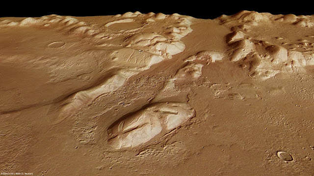
Phlegra Montes (1,4km - 870 mi)
Mars (Solar system)
About that image
The
High-Resolution Stereo Camera on ESA’s Mars Express collected the data
for these images on 1 June 2011 during orbit 9465. This perspective view
has been calculated from the Digital Terrain Model derived from the
stereo channels.
Courtesey ESA/DLR/FU Berlin (G. Neukum),CC BY-SA 3.0 IGO
The mountains
The
Phlegra Montes are a system of eroded Hesperian–Noachian-aged massifs
and knobby terrain in the mid-latitudes of the northern lowlands of
Mars, extending northwards from the Elysium Rise towards Vastitas
Borealis for nearly 1,400 km (870 mi). The mountain ranges separate the
large plains provinces of Utopia Planitia (west) and Amazonis Planitia
(east), and were named in the 1970s after a classical albedo feature.
The massif terrains are flanked by numerous parallel wrinkle ridges
known as the Phlegra Dorsa. The mountain ranges were first mapped
against imagery taken during NASA's Viking program in the 1970s, and the
area is thought to have been uplifted due to regional-scale compressive
stresses caused by the contemporary formations of the Elysium and
Tharsis volcanic provinces. Recent research has unveiled the presence of
extensive thrust faulting bounding the massif terrains. Since the
2010s, researchers have proposed the presence of a significant late
Amazonian glaciation event along the Martian northern mid-latitudes,
citing the presence of lineated valley fills, lobate debris aprons, and
concentric crater fills. The presence of ring mold craters imply that
significant stores of water ice may continue to persist in these
terrains. Features interpreted as eskers have been observed in the
southern Phlegra Montes. However, whether this glaciation was localized
or of regional scale remains subject to debate in the scientific
community.
About the mission
Mars Express is a space
exploration mission being conducted by the European Space Agency (ESA).
The Mars Express mission is exploring the planet Mars, and is the first
planetary mission attempted by the agency. "Express" originally referred
to the speed and efficiency with which the spacecraft was designed and
built.However, "Express" also describes the spacecraft's relatively
short interplanetary voyage, a result of being launched when the orbits
of Earth and Mars brought them closer than they had been in about 60,000
years. Mars Express consists of two parts, the Mars Express Orbiter and
Beagle 2, a lander designed to perform exobiology and geochemistry
research. Although the lander failed to fully deploy after it landed on
the Martian surface, the orbiter has been successfully performing
scientific measurements since early 2004, namely, high-resolution
imaging and mineralogical mapping of the surface, radar sounding of the
subsurface structure down to the permafrost, precise determination of
the atmospheric circulation and composition, and study of the
interaction of the atmosphere with the interplanetary medium. Due to the
valuable science return and the highly flexible mission profile, Mars
Express has been granted several mission extensions. The latest was
approved on 1 October 2020 and runs until 31 December 2022. Some of the
instruments on the orbiter, including the camera systems and some
spectrometers, reuse designs from the failed launch of the Russian Mars
96 mission in 1996 (European countries had provided much of the
instrumentation and financing for that unsuccessful mission). The design
of Mars Express is based on ESA's Rosetta mission, on which a
considerable sum was spent on development. The same design was also used
for ESA's Venus Express mission in order to increase reliability and
reduce development cost and time. Because of these redesigns and
repurposings, the total cost of the project was about $345 million- less
than half of comparable U.S. missions. Arriving at Mars in 2003, 18
years, 9 months and 10 days ago (and counting), it is the second longest
surviving, continually active spacecraft in orbit around a planet other
than Earth, behind only NASA's still active 2001 Mars Odyssey.
______________________________
2022- Wandering Vertexes
A blog by Francis Rousseau

