google.com, pub-0288379932320714, DIRECT, f08c47fec0942fa0 GRAVIR LES MONTAGNES... EN PEINTURE: October 2019

Thursday, October 31, 2019

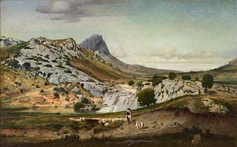
PIC SAINT LOUP PAINTED BY EUGÈNE CASTELNAU


https://wanderingvertexes.blogspot.com/2019/10/pic-saint-loup-painted-by-eugene.html


EUGÈNE CASTELNAU (1827–1894)
Pic Saint Loup (658 m - 2,159ft)
France (Occitanie)

In  Les Garrigues du Pic Saint Loup, oil on canvas, 1859- Musée Fabre, Montpellier, France 

The mountain
 Pic Saint Loup   (658 m - ) is a mountain in the Occitanie region of France located on the edge of the municipalities of Valflaunes and Cazevieille.Located about 20 km north of Montpellier, the peak is visible from a large part of the department of Hérault, the coast and the Gard, hence its profile evokes a point rushing to the sky. It is one of the most beautiful natural and hiking sites in the Garrigues region, the Cévennes outpost. The mountain is also considered the "Sainte-Victoire" of Languedoc. It forms, with the mountain of Hortus facing it to the north, a protected natural site and hosts a number of birds of prey..
From the top of its sharp ridge, the peak Saint-Loup stands against the elements. A large iron cross is erected, an observation post and the chapel of an old hermitage.

The painter
Eugene Castelnau belongs to a family of the Protestant bourgeoisie of Montpellier. and the cousin of the painter Frédéric Bazille. He followed Charles Matet's drawing classes at the Montpellier School of Fine Arts, and in 1841 he left his hometown for Switzerland.  He then studied in Paris, in the workshops of Alexandre Calame and Charles Gleyre.
In 1853, Eugene Castelnau stayed in Italy. In Rome, he attended the painter Ernest Hébert, he traveled for four months the campaign of Rome and the Bay of Naples. Édouard-Auguste Imer noted day after day the details of the trip. His first painting, Les Marais pontins, is presented at the 1855 World's Fair in Paris.
Eugene Castelnau participated in the political and artistic life of Montpellier. He was deputy mayor from September 1870 to April 1871. In 1873, he became president of the Artistic Society of Herault.

___________________________________________
2019 - Wandering Vertexes...
by Francis Rousseau
Wednesday, October 30, 2019

MONTE PERDIDO BY EUGÈNE DELACROIX


EUGÈNE  DELACROIX  (1798-1863)
 Monte Perdido / Mont Perdu  (3,355 m -11,007ft)
Spain

In Album Pyrénées 1845, watercolor,  Musée du Louvre, Paris

The mountain
Monte Perdido (3,355 m -11,007ft), Mont Perdu in French, located in Spain, near the French-Spanish border, is the highest summit above sea level on the ridge separating the canyons of Ordesa and Pineta in the Pyrénées. This is the central peak of Tres Hermanas (Spanish) consist of the cylinder Marboré, the Soum de Ramond, and Monte Perdido itself.
Observable from the peaks popular at the time (including the Pic du Midi de Bigorre), Mount Perdido is no longer visible from the French valleys, as located behind the watershed line between France and Spain.
The limestone, rich in fossils are marine sedimentary origin. These sediments occupying a shallow sea were raised during the formation of the Pyrenees there are 40 million years (see article Geology of the Pyrénées).The summit a form of typical pyramidal peak of erosion by glaciers time of glaciation, he is still on the northeast side of the mountain the Monte Perdido glacier.
Ramond Carbonnières, is the firstpersonn to have discover Mount Perdu. Since his first stay in Barèges, in 1787, he was fascinated by the "massive limestone" of Marboré. In 1796, convinced that the nature of the limestone Marboré is "ordinary" Ramond determines an access route to the summit: the Estaubé Valley.

The painter
Ferdinand Victor Eugène Delacroix was a French Romantic artist regarded from the outset of his career as the leader of the French Romantic school. As a painter and muralist, Delacroix's use of expressive brushstrokes and his study of the optical effects of colour profoundly shaped the work of the Impressionists, while his passion for the exotic inspired the artists of the Symbolist movement. A fine lithographer, Delacroix illustrated various works of William Shakespeare, the Scottish author Walter Scott and the German author Johann Wolfgang von Goethe.
In contrast to the Neoclassical perfectionism of his chief rival Ingres, Delacroix took for his inspiration the art of Rubens and painters of the Venetian Renaissance, with an attendant emphasis on colour and movement rather than clarity of outline and carefully modeled form. Dramatic and romantic content characterized the central themes of his maturity, and led him not to the classical models of Greek and Roman art, but to travel in North Africa, in search of the exotic. Friend and spiritual heir to Théodore Géricault, Delacroix was also inspired by Lord Byron, with whom he shared a strong identification with the "forces of the sublime", of nature in often violent action.
However, Delacroix was given to neither sentimentality nor bombast, and his Romanticism was that of an individualist. In the words of Baudelaire, "Delacroix was passionately in love with passion, but coldly determined to express passion as clearly as possible."
In 1832, Delacroix traveled to Spain and North Africa, as part of a diplomatic mission to Morocco shortly after the French conquered Algeria. He went not primarily to study art, but to escape from the civilization of Paris, in hopes of seeing a more primitive culture. He eventually produced over 100 paintings and drawings of scenes from or based on the life of the people of North Africa, and added a new and personal chapter to the interest in Orientalism. Delacroix was entranced by the people and the costumes, and the trip would inform the subject matter of a great many of his future paintings. He believed that the North Africans, in their attire and their attitudes, provided a visual equivalent to the people of Classical Rome and Greece: "The Greeks and Romans are here at my door, in the Arabs who wrap themselves in a white blanket and look like Cato or Brutus…"
He managed to sketch some women secretly in Algiers, as in the painting Women of Algiers in their Apartment (1834), but generally he encountered difficulty in finding Muslim women to pose for him because of Muslim rules requiring that women be covered. Less problematic was the painting of Jewish women in North Africa, as subjects for the Jewish Wedding in Morocco (1837–41).
While in Tangier, Delacroix made many sketches of the people and the city (see painting above), subjects to which he would return until the end of his life. Animals—the embodiment of romantic passion—were incorporated into paintings such as Arab Horses Fighting in a Stable (1860), The Lion Hunt (of which there exist many versions, painted between 1856 and 1861), and Arab Saddling his Horse (1855).

___________________________________________
2019 - Wandering Vertexes...
by Francis Rousseau


Tuesday, October 29, 2019

THE STROMBOLI VOILCANO BY CORNELIUS DE BRUYN


CORNELIUS DE BRUYN (1652-1726)  
Stromboli volcano (924 m -3,031 ft)
Italy (Island of Stromboli)  

In Stromboli, engraving, 1714
The mountain
Stromboli  is a small island in the Tyrrhenian Sea, off the north coast of Sicily, containing one of the three active volcanoes (924 m -3,031 ft) in Italy. It is one of the eight Aeolian Islands, a volcanic arc north of Sicily. This name is derived from the Ancient Greek name Strongulē which was given to it because of its round swelling form. The island's population is about 500. The volcano has erupted many times and is constantly active with minor eruptions, often visible from many points on the island and from the surrounding sea, giving rise to the island's nickname "Lighthouse of the Mediterranean". The most recent major eruption was on 13 April 2009. Stromboli stands 926 m (3,034 ft) above sea level, and over 2,700 m (8,860 ft) on average above the sea floor. There are three active craters at the peak. A significant geological feature of the volcano is the Sciara del Fuoco ("Stream of fire"), a big horseshoe-shaped depression generated in the last 13,000 years by several collapses on the northwestern side of the cone. Two kilometers to the northeast lies Strombolicchio, the volcanic plug remnant of the original volcano.
Mt. Stromboli has been in almost continuous eruption for the past 2,000 years. A pattern of eruption is maintained in which explosions occur at the summit craters, with mild to moderate eruptions of incandescent volcanic bombs, at intervals ranging from minutes to hours. This Strombolian eruption, as it is known, is also observed at other volcanoes worldwide. Eruptions from the summit craters typically result in a few short, mild, but energetic bursts, ranging up to a few hundred meters in height, containing ash, incandescent lava fragments and stone blocks. Stromboli's activity is almost exclusively explosive, but lava flows do occur at times when volcanic activity is high: an effusive eruption occurred in 2002, the first in 17 years, and again in 2003, 2007, and 2013–14. Volcanic gas emissions from this volcano are measured by a Multi-Component Gas Analyzer System, which detects pre-eruptive degassing of rising magma, improving prediction of volcanic activity.

The artist
Cornelius de Bruyn, (also called Cornelis de Bruijn) was a Dutch artist and traveler. He made two large tours and published illustrated books with his observations of people, buildings, plants and animals.
During his first tour, he visited Rome. He travelled in Egypt and climbed to the top of a pyramid where he left his signature. De Bruijn made secret drawings of Jerusalem, then part of the Ottoman Empire. His drawings of Palmyra are copies. De Bruijn reached Cyprus and stayed among the Dutch merchants in Smyrna and Constantinople.
From 1684 he worked in Venice with the painter Johann Carl Loth, returning in 1693 to The Hague, where he sold his souvenirs. In 1698 he published his book with drawings, which was a success and was translated in several languages. Two examples have colored illustrations, the first color prints in history. Among his drawings were the first pictures of the interior of the Great Pyramid and Jerusalem that became known in Europe.
In 1701 he headed for Archangelsk. During his second tour he visited the Samoyeds in northern Russia. In Moscow he became acquainted with emperor Peter the Great: de Bruijn painted his nieces, and the paintings were sent to possible candidates for marriage.
In late April 1703, De Brujin left Moscow along with the party of an Armenian merchants from Isfahan whose name he recorded as Jacob Daviedof.  De Bruijin and the Armenians sailed down the Moscow River, the Oka and the Volga, eventually reaching Astrakhan. Thanks to de Bruijn's short stopover in Nizhny Novgorod during the Easter holidays, we now have his description of that major center of the Russian Volga trade as it existed in 1703, with its Kremlin, stone churches, and a lively bar (kabak) scene.
Leaving the borders of the Russian state, de Brujin arrived to Persia, where he made drawings of towns like Isfahan and Persepolis (1704–1705). He continued to Java and returned to Persia, Russia, and ultimately the Netherlands.
His drawings of Persepolis, a city destroyed by Alexander the Great, caused a sensation. The mayor of Amsterdam Nicolaes Witsen and a member of the Royal Society probably asked him to draw the city famous for its 40 columns. For a century, they were the best prints available to western scholars. De Bruijn was accused of plagiarism and his second book, Reizen over Moskovie was not such a success. From Amsterdam he fled to Vianen.
De Bruijn died in Utrecht. It is not known when and where he was buried.
De Bruijn, who had read every Greek and Latin source he had been able to obtain, displays a convincing knowledge of subjects, at times going into the humorous. In Persia, he obtained a copy of Firdausi's Shahnamê, which he summarized and made accessible to the west.
___________________________________________
2019 - Wandering Vertexes...
by Francis Rousseau


Monday, October 28, 2019

TRE CIME PAINTED BY KONRAD PETRIDES


KONRAD PETRIDES  (1864-1944)
Tre Cime di Lavaredo (2,999 m -  9,839 ft)
Italy   

In  Tre  Cime, Dolomiten,  oil on canvas

The mountain 
Tre Cime di Lavaredo (2,999 m -  9,839 ft)   (The three peaks of Lavaredo)  also called Drei Zinnen by Germans, are three distinctive battlement-like peaks, in the Sexten Dolomites of northeastern Italy. They are probably one of the best-known mountain groups in the Alps, and one of the most photographed in Italy. The three peaks are named, from east to west, "little peak" (Cima Piccola), "big peak" (Cima Grande) and "western peak" (Cima Ovest). The Cima Grande has an elevation of 2,999 metres (9,839 ft). It stands between the Cima Piccola, at 2,857 metres (9,373 ft), and the Cima Ouest, at 2,973 metres (9,754 ft).
Until 1919 the peaks formed part of the border between Italy and Austria. Now they lie on the border between the Italian provinces of South Tyrol and Belluno and still are a part of the linguistic boundary between German-speaking and Italian-speaking majorities. Both communities still battle today about the exact border line.
The surrounding around Tre Cime di Lavaredo and the path leading to the Three Peaks is popular among hikers. There are numerous routes leading from the surrounding communities to and around the peaks. The road that leads to the southern side of the Three Peaks was built during World War I as a transport road by pioneers to support the front troops in that war. Because of this there are a number of fortifications, man-made caves, and commemorative plaques in the area.
The peaks are also great for climbing. The first ascent of the Cima Grande was made in the early 1869 by Paul Grohmann, Franz Innerkofler and Peter Salcher. The Cima Ovest was first climbed exactly ten years later, in 1879. The Cima Piccola was conquered two years later on 1881. The partly overhanging northern face of the Cima Grande is considered by climbers to be one of the great north faces of the Alps, and was first climbed in 1933 after an ascent time of 3 days and 2 nights.

The artist 
Konrad Petrides  was a Viennese landscape and stage painter in the studio Hermann Burghart, where the painters Anton Brioschi, Josef Kautsky, Georg Jany and Leopold Rothaug also worked. He also painted many veduras, especially from Lower Austria and East Tyrol. Petrides was a member of the Dürer League, in whose exhibitions he participated and whose silver medal he received in 1919. In 1904 he also received the gold medal at the World's Fair in St. Louis, USA.

_______________________________
2019 - Wandering Vertexes...
by Francis Rousseau

Sunday, October 27, 2019

PIZ BERNINA BY CARL FRIEDRICH SEIFFERT


CARL FRIEDRICH SEIFFERT (1809-1891)
Piz Bernina (4, 049 m- 13, 283ft)
Switzerland - Italy border

In View of the Lago di Poschiavo with the Bernina Range, 1859 Oil on canvas, 50.5 x 87 cm Private collection

The mountain
Piz Bernina or Pizzo Bernina (4, 049m- 13, 283ft) is the highest mountain in the Eastern Alps, the highest point of the Bernina Range, and the highest peak in the Rhaetian Alps. It is located south of Pontresina and near the major Alpine resort of St. Moritz, in the Engadin valley with the massif partially in Italy. The mountain can be seen from different viewpoints with the use of ski-lifts from Diavolezza, Piz Corvatsch or Piz Nair. It is also the most easterly mountain higher than 4,000 m (13,000 ft) in the Alps, the highest point of the Swiss canton of Graubünden, and the fifth-most prominent peak in the Alps. The minor summit (4,020 m -13,190 ft) known as La Spedla is the highest point in the Italian Lombardy region. The mountain was named after the Bernina Pass in 1850 by Johann Coaz, who also made the first ascent. The prefix Piz comes from the Romansch language in Graubünden; any mountain with that name can be readily identified as being located in southeastern Switzerland.

The painter
Not a lot of informations about the german academic painter Carl Seiffert specialized in mountains of Switzerland and Italy,  His work has been offered at auction multiple times, with realized prices ranging from $445 USD to $9,530 USD  depending on the size and medium of the artwork. Since 2017 the record price for this artist at auction is $9,530 USD for Blick über die Ruinen des Amphitheaters von Taormina auf Sizilien auf den Ätna, sold at Bassenge in 2017 which one of his most famous.

_______________________________
2019 - Wandering Vertexes...
by Francis Rousseau 


Saturday, October 26, 2019

HALEMA'UMA 'U CRATER PAINTED BY DAVID HOWARD HITCHCOCK


DAVID HOWARD HITCHCOCK (1861-1943),
Halemaʻumaʻu Crater / Kilauea (1,247 m - 4,091 ft) 
United states of America (Hawaii) 
In Halemaumau, lake of fire, oil on board,  1888

The volcano
Halemaʻumaʻu Crater (six syllables: HAH-lay-MAH-oo-MAH-oo) is a pit crater within the much larger summit caldera of Kīlauea in Hawaii Volcanoes National Park. The roughly circular crater was 770 meters (2,530 ft) x 900 m (2,950 ft) before collapses that roughly doubled the size of the crater after May 3, 2018. Halemaʻumaʻu is home to Pele, goddess of fire and volcanoes, according to the traditions of Hawaiian religion. Halemaʻumaʻu means "house of the ʻāmaʻu fern".
Halemaʻumaʻu contained an active lava lake for much of the time before 1924, and was the site of several eruptions during the 20th century. The crater again contained an active lava lake between 2008 and 2018, usually fluctuating between 20 to 150 meters below Halemaʻumaʻu's crater floor, though at times the lava lake rose high enough to spill onto crater floor.
As new volcanic vents opened in lower Puna in May 2018, the level of the lava lake began to drop in early May 2018, eventually to the point where the lava lake was no longer visible. The subsidence of the lava lake was accompanied by a period of explosions, earthquakes, large clouds of ash and toxic gas, and finally a gradual collapse of the summit caldera around Halemaʻumaʻu Crater, resulting in the closure of the Hawaii Volcanoes National Park from May 10 to September 22, 2018. The collapse events ceased abruptly on August 2, 2018.
In the summer of 2019, for the first time in recorded history, a water pond appeared in Halemaʻumaʻu. The greenish pond has deepened and enlarged since first being observed.

The painter
David Howard Hitchcock  was an American painter of the  so called Volcano School, known for his depictions of Hawaii.  Born in Hilo, Hawaii, Hitchcock attended Oberlin College in Ohio, where he saw his first art exhibition. Back in Hawaii, he wandered the volcano wilderness with a sketch pad and watercolors. French artist Jules Tavernier, painting in Hawaii, saw Hitchcock's sketches and convinced him to study art seriously.
After Tavernier's death in 1889 Hitchcock studied painting at the National Academy of Design in New York City and from 1891 to 1893 at the Académie Julian in Paris under Aldolphe Bourguereau and Gabriel Joseph Ferrier. His work was accepted at the Paris Salon of 1893. He returned to Hawaii in 1893.
In 1894, Hitchcock became one of the founders of the Kilohana Art League, an active art program in Honolulu at the turn of the century, exhibiting at least twice a year.
During extensive travels in the 1900s, Hitchcock explored the volcanic regions of the island of Hawaii, and in July 1907 he made his first visit to the island of Kauaʻi, where he painted Waimea Canyon. He toured and painted the island of Maui in 1915 and 1916. He was a leading member of Hawaii's Volcano School, and his most important paintings date from about 1905 to 1930.
His canvases were displayed in 1924 at the First Hawaiian and South Seas Exhibition in the Los Angeles Museum in Exposition Park. In 1927, he exhibited several paintings at the opening of the Honolulu Museum of Art, where he had a retrospective exhibition in 1936. In 1939 he exhibited in the Golden Gate International Exposition in San Francisco and at the 1939 New York World's Fair.

_______________________________

2019 - Wandering Vertexes...
by Francis Rousseau

Friday, October 25, 2019

ROTUI PAINTED BY JOHN LA FARGE


JOHN LA FARGE (1835-1910)
Rotui ( 899 m - 2,949 ft)
French Polynesia

In Uponohu, End of Cooks Bay, Island of Moorea, watercolor

The mountain
Mount Rotui  ( 899 m - 2,949 ft )is a  peak on the island of Moorea (French Polynesia), beetwen Ōpūnohu Bay and Cook Bay. Despite the low altitude of the peaks, the mountains of Moorea are among the most rugged in the world and every bit as rugged as the Himalayas. Unlike the Himalayas however, most peaks on this and the surrounding islands are considered impossible to climb and many still await first ascents. 
Rotui is the easiest summit to climb on Moorea, but still is a nice and exciting climb. It can be a bit risky while descending in the rain, but it is not as dangerous to climb as Mouaputa.
While Moorea and Tahiti are very popular with tourist, expect to have the mountains all to yourself.

The Painter 
John La Farge was an American painter, muralist, stained glass window maker, decorator, and writer.
born in New York City to wealthy French parents and was raised bilingually; as a child, he and his brothers produced a handmade magazine in French entitled Le Chinois.  His interest in art began during his studies at Mount St. Mary's University in Maryland and St. John's College (now Fordham University) in New York.  He initially intended to study law, but this changed after his first visit to Paris, France in 1856. Stimulated by the arts in the city, he studied with Thomas Couture and became acquainted with notable literary people. La Farge also studied with the painter William Morris Hunt in Newport, Rhode Island.
La Farge's earliest drawings and landscapes, from his studies in Newport, show marked originality, especially in the handling of color values. Many of La Farge's mythological and religious paintings, including Virgil, were executed in an area of Rhode Island known as "Paradise," in a forest which La Farge called "The Sacred Grove" after Virgil.
He was a pioneer in the study of Japanese art, the influence of which is seen in his work. During his life, La Farge maintained a studio at 51 West 10th Street in Greenwich Village, which now is part of the site of Eugene Lang College at the New School University.
Between 1859 and 1870, he illustrated Tennyson's Enoch Arden and Robert Browning's Men and Women.
In the 1870s, La Farge began to do murals, which became popular for public buildings as well as churches. His first mural was done in Trinity Church, Boston, in 1873. Then followed his decorations in the Church of the Ascension  and St. Paul's Chapel, New York.  For the Minnesota State Capitol at St. Paul, he executed at age 71 four great lunettes representing the history of law. He created a similar series based on the theme of Justice for the State Supreme Court building at Baltimore, Maryland. He also took private commission from wealthy patrons (e.g. Cornelius Vanderbilt) and was reputedly worth $150,000 at one point.
La Farge made extensive travels in Asia and the South Pacific, which inspired his painting. He visited Japan in 1886, and the South Seas in 1890 and 1891, in particular spending time and absorbing the culture of Tahiti. Henry Adams accompanied him on these trips as a travel companion. He visited Hawaii in September 1890, where he painted scenic spots on Oahu and traveled to the Island of Hawaii to paint an active volcano.
In 1892, La Farge was brought on as an instructor with the Metropolitan Museum of Art Schools to provide vocational training to students in New York City. He served as President of the National Society of Mural Painters from 1899 to 1904.
La Farge died at Butler Hospital, in Providence, Rhode Island in 1910. His papers, together with some of those of certain children and grandchildren, are held by Yale University Library.


_________________________________________
2019 - Wandering Vertexes...
by Francis Rousseau

Thursday, October 24, 2019

KILAUEA BY CONSTANCE GORDON-CUMMING


CONSTANCE GORDON-CUMMING (1837–1924)
 Kilauea  (1,247 m - 4,091 ft) 
 United States of America  (Hawaii)

 In Kilauea Temporary Chimneys and Fire Fountains, watercolor, c.1880

The volcano
Kīlauea (1,247 m-4,091 ft) is a currently active shield volcano in the Hawaiian Islands, and the most active of the five volcanoes that together form the island of Hawaiʻi. Located along the southern shore of the island, the volcano is between 300,000 and 600,000 years old and emerged above sea level about 100,000 years ago. It is the second youngest product of the Hawaiian hotspot and the current eruptive center of the Hawaiian–Emperor seamount chain. Structurally, Kīlauea has a large, fairly recently formed caldera at its summit and two active rift zones, one extending 125 km (78 mi) east and the other 35 km (22 mi) west, as an active fault of unknown depth moving vertically an average of 2 to 20 mm (0.1 to 0.8 in) per year.
More about Kilauea

The painter
Constance Frederica “Eka” Gordon-Cumming was a noted Scottish travel writer and painter. Born in a wealthy family, she travelled around the world and painted described scenes and life as she saw them. Constance Gordon-Cumming was a prolific landscape painter, mostly in Asia and the Pacific. She painted over a thousand watercolors and worked with a motto to ‘never a day without at least one careful-coloured sketch’ starting her day at 5 am while in India. Places she visited include Australia, New Zealand, America, China, and Japan.
She arrived in Hilo, Hawaii in October 1879, and was among the first artists to paint the active volcanoes. Her Hawaii travelogue, Fire Fountains: The Kingdom of Hawaii, was published in Edinburgh in 1883. She had several dangerous moments but her travel ended in 1880 when the Montana that she was on ran into rocks at Holyhead. While most of the passengers took the lifeboat, she stayed on last along with the captain to save her paintings and was rescued many hours later. She returned to live at Crieff with her widowed sister Eleanor and continued to write books.
Her best known books are At Home in Fiji and A Lady's Cruise on a French Man-of-War. The latter book resulted from an invitation to join a French ship put into service for the Bishop of Samoa so that he could visit remote parts of his far-flung diocese.
Miss Gordon-Cumming received much criticism from male writers of the era, perhaps because she did not fit in the traditional Victorian role of women, as she often traveled alone and unaided.
In any case, her landscape drawings and watercolors seem to be universally admired.

_________________________________________
2019 - Wandering Vertexes...
by Francis Rousseau

Wednesday, October 23, 2019

MOUNT EREBUS BY CHARLES HAMILTON SMITH

 
CHARLES HAMILTON SMITH (1776-1859) 
Mont Erebus (3, 794 m - 12, 448ft)
Antarctica (Ross Island)
In Mount Erebus and Beaufort Island- Watercolour from Views of Polar region, 
 Yale Center for British arts, Connectitcut, USA


The mountain
Mount Erebus (3, 794 m - 12, 448ft), not to be confused with Mount Elbrus is the second-highest volcano in Antarctica (after Mount Sidley) and the southernmost active volcano on Earth. It is the sixth highest ultra mountain on an island, located on Ross Island, which is also home to three inactive volcanoes: Mount Terror, Mount Bird, and Mount Terra Nova.
The volcano has been active since c. 1.3 million years ago and is the site of the Mount Erebus Volcano Observatory run by the New Mexico Institute of Mining and Technology.
Mount Erebus was discovered on January 27, 1841 (and observed to be in eruption) by polar explorer Sir James Clark Ross who named it and its companion, Mount Terror, after his ships, Erebus and Terror (which were later used by Sir John Franklin on his disastrous Arctic expedition). Erebus is a dark region in Hades in Greek mythology. Present with Ross on the Erebus was the young Joseph Hooker, future president of the Royal Society and close friend of Charles Darwin. Erebus was an Ancient Greek primordial deity of darkness, the son of Chaos.
The mountain was surveyed in December 1912 by a science party from Scott’s Terra Nova Expedition who also collected geological samples. Two of the camp sites they used have been recognised for their historic significance:
- Upper “Summit Camp” site (HSM 89) consists of part of a circle of rocks, which were probably used to weight the tent valances.
- Lower “Camp E” site (HSM 90) consists of a slightly elevated area of gravel as well as some aligned rocks, which may have been used to weight the tent valances.
They have been designated Historic Sites or Monuments following a proposal by the United Kingdom, New Zealand and the United States to the Antarctic Treaty Consultative Meeting.
Mount Erebus is classified as a polygenetic stratovolcano. The bottom half of the volcano is a shield and the top half is a stratocone. The composition of the current eruptive products of Erebus is anorthoclase-porphyritic tephritic phonolite and phonolite, which are the bulk of exposed lava flow on the volcano. Erebus is the world's only presently erupting phonolite volcano.

The artist 
Lieutenant-Colonel Charles Hamilton Smith,  was an English artist, naturalist, antiquary, illustrator, soldier, and... spy as well !. His military career began in 1787, when he studied at the Austrian academy for artillery and engineers at Mechelen and Leuven in Belgium (his native country). Although his military service, which ended in 1820 and included the Napoleonic Wars, saw him travel extensively (including the West Indies, Canada, United States, Southern and Northern Europe and ...Antarctica).
As a prolific self-taught illustrator (over 38,000 drawings!) He left quite an important number of books of  beautifully watercolored landscapes taken all around the world. those nooks of watercolors are nowadays in the collections of  the Yale Center From British Art. Among them  :
Views of France, Volume I (81 watercolors), Views of France, Volume II (93 watercolors), 
Views of England and Wales, Volume I (82  watercolors),  Views of England and Wales, Volume II (74  watercolors),
Views of Northern Europe, Volume I (68watercolors) , Views of Northern Europe, Volume II (78)  watercolors),  
Views of Polar Regions (75  watercolors) (see above) 
Views of Spain, Volume I (69 watercolors), Views of Spain, Volume II (72 watercolors), 
But one of his noteworthy achievements was an 1800 experiment to determine which color should be used for military uniforms.  He is also known in military history circles for Costume of the Army of the British Empire, produced towards the end of the Napoleonic Wars and an accurate depiction of contemporary British uniform.
As an antiquarian, he also produced, in collaboration with Samuel Rush Meyrick, Costume of the Original Inhabitants of the British Islands, 1815, and The Ancient Costume of England, with historical illustrations of medieval knights, ladies, shipsm and battles. 
He also wrote on the history of the Seven Years' War and TheNatural history of dogs.
Quite a productive fellow ! 
___________________________________________
2019 - Wandering Vertexes...
by Francis Rousseau

Tuesday, October 22, 2019

THE MZAB PLATEAU PAINTED BY NASR'EDDINE ETIENNE DINET


NASR'EDDINE ETIENNE DINET (1861-1929),
The Mzab Plateau (526m - 1,725ft)
Algeria (Sahara)

In Caravane se dirigeant vers Ghardaia (Caravan on the way to Ghardaia), oil on canvas

The formation
The Mzab plateau is a rocky formation whose altitude varies between 300 and 800 meters.  The average altitude is 500 meters (Ghardaia: 526 meters).This relief, of which the origin is  from the Upper Cretaceous, is in the form of a vast stony expanse and brown and blackish rocks. The grounds are limestone. Their roughly horizontal structure indicates that they have remained in place, away from the orogenic movements, since their formation.
The deepest valleys bordered by rocky cliffs with steep slopes have a gradient that rarely exceeds 100 meters in relation to the plateau.
The M'zab is therefore generally a flat region but where fluvial erosion, combined with the action of the desert climate, has created a multitude of superficial accidents that make communications most difficult.
Due to  the low latitude and the moderate altitude, the temperature is very high in summer (absolute maximum in Ghardaia: 50 ° C), moderately cool in winter (absolute minimum: minus 1 ° C in Ghardaia).  In winter as in summer, the diurnal variation of temperature is important, due to the perfect dryness of the atmosphere. For the same reason, the brightness is intense.
Sandwash from the southwest periodically accentuate the dryness of the climate. They are particularly frequent and violent in late winter and early spring.
The Mzab Valley is part of World Heritage since 1982, as an untouched example of a traditional human habitat perfectly adapted to the environment.

The painter 
Nasr'Eddine Dinet (born as Alphonse-Étienne Dinet in Paris) was a French orientalist painter.
Compared to modernist painters such as Henri Matisse, who also visited northern Africa in the first decade of the 20th century, Dinet’s paintings are extremely conservative. They are highly mimetic, indeed ethnographic, in their treatment of their subject.
Dinet’s understanding of Arab culture and language set him apart from other orientalist artists. Surprisingly, he was able to find nude models in rural Algeria. Before 1900, most of his works could be characterized as "anecdotal genre scenes". As he became more interested in Islam, he began to paint religious subjects more often. He was active in translating Arabic literature into French, publishing a translation of an Arab epic poem by Antarah ibn Shaddad in 1898.
Dinet was born the son of a prominent French judge.   From 1871, he studied at the prestogious Lycée Henry IV in Paris, where the future president Alexandre Millerand was also among the students. Upon graduation in 1881 he enrolled in the École nationale supérieure des Beaux-Arts and entered the studio of Victor Galland. The following year he studied under William Bouguereau and Tony Robert-Fleury at the Académie Julian. He also exhibited for the first time at the Salon des artistes français.
Dinet made his first trip to Bou Saâda by the Ouled Naïl Range in southern Algeria in 1884, with a team of entomologists. The following year he made a second trip on a government scholarship, this time to Laghouat. At that time he painted his first two Algerian pictures: les Terrasses de Laghouat  (Laghouat Terraces) or  Oued M’Sila après l’orage (Oued M'Sila after the storm).
He won the silver medal for painting at the Exposition Universelle in 1889, and in the same year founded the Société Nationale des Beaux-Arts along with Meissonier, Puvis de Chavannes, Rodin, Carolus-Duran and Charles Cottet. In 1887 he further founded with Léonce Bénédite, director of the Musée du Luxembourg, the Société des Peintres Orientalistes Français.
In 1903 he bought a house in Bou Saâda and spent three quarters of each year there.
He announced his conversion to Islam in a private letter of 1908, and completed his formal conversion in 1913, upon which he changed his name to Nasr’Eddine Dinet. In 1929 he and his wife undertook the Hajj to Mecca. The respect he earned from the natives of Algeria was reflected by the 5,000 who attended his funeral on 12 January 1930 in Bou Saâda. There he was eulogized by the former Governor General of Algeria Maurice Viollette.

.___________________________________________
2019 - Wandering Vertexes...
by Francis Rousseau

Monday, October 21, 2019

THE KILIMANDJARO PAINTED BY ANTHONY MWANGI


ANTHONY MWANGI (bn. 1969)
Kilimandjaro (5,885m - 19, 340ft)
Tanzania

In Kilimandjaro Morning, oil on canvas


The mountain 
 Mount Kilimanjaro (5,885m - 19, 340ft) is a dormant volcano in Tanzania composed of three volcanic cones, "Kibo", "Mawenzi", and "Shira.
The Kilimandjaro is the highest mountain in Africa. The first recorded ascent to the summit was by Hans Meyer and Ludwig Purtscheller in 1889.
The mountain is part of the Kilimanjaro National Park and is a major climbing destination.
The mountain has been the subject of many scientific studies because of its shrinking glaciers, especially since 200.
The origin of the name "Kilimanjaro" is not precisely known, but a number of theories exist. European explorers had adopted the name by 1860 and reported that "Kilimanjaro" was the mountain's Kiswahili name. The 1907 edition of The Nuttall Encyclopædia also records the name of the mountain as "Kilima-Njaro", as well as the title of the watercolor above. Johann Ludwig Krapf wrote in 1860 that Swahilis along the coast called the mountain Kilimanjaro. Although he did not support his claim, he claimed that "Kilimanjaro" meant either "mountain of greatness" or "mountain of caravans". Under the latter meaning, "Kilima" meant "mountain" and "Jaro" possibly meant "caravans". Jim Thompson claimed in 1885, although he also did not support his claim, that the term Kilima-Njaro "has generally been understood to mean" the Mountain (Kilima) of Greatness (Njaro). Though not improbably it may mean the "White" mountain. "Njaro" is an ancient Kiswahili word for "shining". Others have assumed that "Kilima" is Kiswahili for "mountain".
In the 1880s, the mountain became a part of German East Africa and was called "Kilima-Ndscharo" in German following the Kiswahili name components.
On 6 October 1889, Hans Meyer reached the highest summit on the crater ridge of Kibo. He named it "Kaiser-Wilhelm-Spitze" ("Kaiser Wilhelm peak").
That name apparently was used until Tanzania was formed in 1964, when the summit was renamed "Uhuru", meaning "Freedom Peak" in Kiswahili.
- More informations about Kilimandjaro

The artist
The kenyan artist Anthony Mwangi, born in 1969, is a painter and a photographer. Apparently self educated in arts, he exhibited his works in Kenya and sold several pieces in Kenyan Galleries. Nowadays he works on commissions and sell canvas prints in his own local Gallery called Small Digger Art Gallery.
Unfortunately this very talented young artist is not very well known in Europe, His painting style is very close to Askeli Gallen Kallela's one. His palette often reminiscent of the great welsh landscaper Sir Kiffin Williams. The future will surely tell us more about his own style and his own pictorial orientations.
Anthony Mwangi, worked as well in 2D, 3D modeling and Animation film. In 2013, he worked on a 21 minute Animated Movie (Makmende II Begins).
To see more of his works click here

___________________________________________
2019 - Wandering Vertexes...
by Francis Rousseau


Sunday, October 20, 2019

KIYANJA / MOUNT BAKER BY VITTORIO SELLA

 
 https://wanderingvertexes.blogspot.com/2019/10/kiyanja-mount-baker-by-vittorio-sella.html 
VITTORIO SELLA (1859-1943) 
Kiyanja or Mount Baker (4,844m- 15,892 ft) 
Uganda
In Mount Baker,  panoramic from Grauer's Rock 1906,The Duke of the Abruzzi expedition 

The mountain
Kiyanja or Mount Baker (4,844m- 15,892 ft) is a mountain in the Rwenzori Mountains National Park in Uganda, 2.8 kilometres (1.7 mi) from the border with the Democratic Republic of the Congo. It is the sixth highest mountain in Africa. Together with Mount Stanley and Mount Speke, it forms a triangle enclosing the upper Bujuku Valley. The nearest peak is Mount Stanley, which is 2.26 kilometres (1.40 mi) to the west. The mountains lie within an area called "The Mountains of the Moon".
Like all peaks in the Ruwenzori Range, Mount Baker has multiple jagged peaks along a ridge. The highest is Edward Peak. The ridge line of Mount Baker was first reached in January 1906 by the Austrian mountaineer Rubert Grauer accompanied by two British missionaries, H. E. Maddox and H. W. Tegart. In February of that year and again in April, the same rocky point was reached by an English expedition, including Alexander F. R. Wollaston, A. B. Wosnam, and M. Carruthers. The highest point of Mount Baker was finally climbed in June by an expedition led by the Duke of the Abruzzi, with Vittorio Sella which climbed all peaks of the other five highest mountains of the Rwenzori (photo above)
The Bakonjo name for the mountain seems to have been (and currently is) "Kiyanja". On his June 1891 expedition into the Ruwenzori, Franz Stuhlmann observed the peak and named it either "Semper" or "Ngemwimbi". The Duke of the Abruzzi renamed the mountain after Samuel Baker, a 19th-century British explorer who in 1864 was the first European to sight and visit Lake Albert, just northeast of the Ruwenzori Mountains, and who had reported to glimpse "great mountainous masses away in the distance, to the south of Lake Albert."

The artist
Vittorio Sella is a mountain italian climber and photographer who took his passion for mountains from his uncle, Quintino Sella, founder of the Italian Alpine Club. He accomplished many remarkable climbs in the Alps, the first wintering in the Matterhorn and Mount Rose (1882) and the first winter crossing of Mont Blanc (1888) and Les Rouies (1900).
He took part in various expeditions outside Italy:
- Three in the Caucasus in 1889, 1890 and 1896 where a summit still bears his name;
- The ascent of Mount Saint Elias in Alaska in 1897;
- Sikkim and Nepal in 1899;
- Possibly climb Mount Stanley in Uganda in 1906 during an expedition to the Rwenzori;
- Recognition at K2 in 1909;
- In Morocco in 1925.
During expeditions in Alaska, Uganda and Karakoram, he accompanied the Duke of Abruzzi, Prince Luigi Amedeo di Savoia.
More about Vittorio Sella 

_______________________________
2019 - Wandering Vertexes...
by Francis Rousseau
 

Saturday, October 19, 2019

KANGCHENJUNGA AT NIGHT BY NICHOLAS ROERICH


https://wanderingvertexes.blogspot.com/2019/10/kangchenjunga-at-night-by-nicholas.html 

NICHOLAS ROERICH (1874-1947), 
Kangchenjunga (8, 538m - 28,169 ft) 
India, Népal

 In  Himalayas at night, Sikkim, 1928-29, tempera on canvas, Private collection

The mountain 
 Kangchenjunga (8,586 m - 28,169 ft) is the  third highest mountain in the world. It  lies partly in Nepal and partly in Sikkim, India.  Kangchenjunga is the second highest mountain of the Himalayas after Mount Everest. Three of the five peaks – Main, Central and South – are on the border between North Sikkim and Nepal. Two peaks are in the Taplejung District, Nepal.
Kangchenjunga Main is the highest mountain in India, and the easternmost of the mountains higher than 8,000 m (26,000 ft).  
Until 1852, Kangchenjunga was assumed to be the highest mountain in the world, but calculations based on various readings and measurements made by the Great Trigonometrical Survey of India in 1849 came to the conclusion that Mount Everest., known as Peak XV at the time, was the highest.  
It is listed int the  Eight Thousanders and as Seven Third Summits
Kangchenjunga is the official spelling adopted by Douglas Freshfield, A. M. Kellas, and the Royal Geographical Society that gives the best indication of the Tibetan pronunciation. Freshfield referred to the spelling used by the Indian Government since the late 19th century. There are a number of alternative spellings including Kangchendzцnga, Khangchendzonga, and Kanchenjunga.  
Local Lhopo people believe that the treasures are hidden but reveal to the devout when the world is in peril; the treasures comprise salt, gold, turquoise and precious stones, sacred scriptures, invincible armor or ammunition, grain and medicine. Kangchenjunga's name in the Limbu language is Senjelungma or Seseylungma, and is believed to be an abode of the omnipotent goddess Yuma Sammang.
It rises in a section of the Himalayas called Kangchenjunga Himal that is limited in the west by the Tamur River, in the north by the Lhonak Chu and Jongsang La, and in the east by the Teesta River. It lies about 128 km (80 mi) east of Mount Everest.
Allowing for further verification of all calculations, it was officially announced in 1856 that
Kangchenjunga was first climbed on 25 May 1955 by Joe Brown and George Band, who were part of a British expedition. They stopped short of the summit as per the promise given to the Chogyal that the top of the mountain would remain inviolate. Every climber or climbing group that has reached the summit has followed this tradition...

The painter 
Nicholas Roerich known also as Nikolai Konstantinovich Rerikh (Никола́й Константи́нович Ре́рих) is quite an important figure of mountain paintings in the early 20th century. He was a Russian painter, writer, archaeologist, theosophist, perceived by some in Russia as an enlightener, philosopher, and public figure. In his youth was he was quite influenced by a movement in Russian society around the occult and was interested in hypnosis and other spiritual practices. His paintings are said to have hypnotic expression.

_______________________________
2019 - Wandering Vertexes...

by Francis Rousseau 

Friday, October 18, 2019

TATEYAMA / 立山 BY KATSUSHIKA HOKUSAÏ


KATSUSHIKA HOKUSAÏ (1760-1849)
Tateyama / 立山 / Mount Tate (3,015 m - 9,892 ft)
Japan

In Tateyama, wood block print

The mountain
Tateyama / 立山 /  Mount Tate  (3,015 m  - 9,892 ft) commonly referred to as simply Tateyama, is a mountain located in the southeastern area of Toyama Prefecture, Japan. It is one of the tallest mountains in the Hida Mountains and along with Mount Fuji and Mount Haku, it is one of Japan's "Three Holy Mountains" (三霊山 Sanreizan). Tateyama is a term for the mountain consisting of three peaks: Ōnanjiyama (大汝山, 3,015m), Oyama (雄山, 3,003m), and Fuji-no-Oritateyama, (富士ノ折立, 2,999m)  which run along a ridge. Public transportation will take climbers and tourists as far as the Murodo Plateau Station at an elevation of 2,450 m (8,038 ft), from where individuals may climb to the peak on foot. These are the only glaciers identified in Japan so far.
It was first climbed by Saeki no Ariyori during Japan's Asuka period. The area was designated the Chūbu-Sangaku National Park on December 4, 1934.

The artist
Katsushika Hokusai (葛飾 北斎) was a Japanese artist, ukiyo-e painter and printmaker of the Edo period. He was influenced by such painters as Sesshu, and other styles of Chinese painting. Born in Edo (now Tokyo), Hokusai is best known as author of the woodblock print series Thirty-six Views of Mount Fuji (富嶽三十六景 c. 1831) which includes the internationally recognized print, The Great Wave off Kanagawa, created during the 1820s.
Hokusai created the "Thirty-Six Views of Mt Fuji " both as a response to a domestic travel boom and as part of a personal obsession with Mount Fuji. In this series, Mt Fuji is painted on different meteorological conditions, in different hours of the days, in different seasons and from different places.
More about Katsushika Hokusai... 

_______________________________
2019 - Wandering Vertexes...
by Francis Rousseau

Thursday, October 17, 2019

MOUNT FUJI / 富士山 BY T. ENAMI / 江南 信國


T. ENAMI NOBUKUNI /  江南 信國  (1859 -1929)
Mount Fuji  (3,776 m  - 12,389 ft)
Japan

In Mount Fuji, colorized gelatine print, 1880

The mountain 
Mount Fuji or Fujiyama  / 富士山 It is located on Honshu Island and is the highest mountain peak in Japan at 3,776.24 m (12,389 ft).
 Several names are attributed to it: "Fuji-san", "Fujiyama" or, redundantly, "Mt. Fujiyama". Usually Japanese speakers refer to the mountain as "Fuji-san".  The other Japanese names for Mount Fuji,  have become obsolete or poetic like: Fuji-no-Yama (ふじの山 - The Mountain of Fuji), Fuji-no-Takane (ふじの高嶺- The High Peak of Fuji), Fuyō-hō (芙蓉峰 - The Lotus Peak), and Fugaku (富岳/富嶽), created by combining the first character of 富士, Fuji, and 岳, mountain.
Mount Fuji is an active stratovolcano that last erupted in 1707–08. Mount Fuji lies about 100 kilometres (60 mi) south-west of Tokyo, and can be seen from there on a clear day.
Mount Fuji's exceptionally symmetrical cone, which is snow-capped several months a year, is a well-known symbol of Japan and it is frequently depicted in art and photographs, as well as visited by sightseers and climbers.
Mount Fuji is one of Japan's Three Holy Mountains (三霊山) along with Mount Tate and Mount Haku. It is also a Special Place of Scenic Beauty and one of Japan's Historic Sites.
It was added to the World Heritage List as a Cultural Site on June 22, 2013. As per UNESCO, Mount Fuji has “inspired artists and poets and been the object of pilgrimage for centuries”. UNESCO recognizes 25 sites of cultural interest within the Mt. Fuji locality. These 25 locations include the mountain itself, Fujisan Hongū Sengen Shrine and six other Sengen shrines, two lodging houses, Lake Yamanaka, Lake Kawaguchi, the eight Oshino Hakkai hot springs, two lava tree molds, the remains of the Fuji-kō cult in the Hitoana cave, Shiraito Falls, and Miho no Matsubara pine tree grove; while on the low alps of Mount Fuji lies the Taisekiji temple complex, where the central base headquarters of Nichiren Shoshu Buddhism is located.

The photographer
T. Enami / 江南 信國 or  Enami Nobukuni  was the trade name of a Meiji period Japanese photographer. The T. of his trade name is thought to have stood for Toshi, though he never spelled it out on any personal or business document.
Born in Edo (now Tokyo) during the Bakumatsu era, Enami was first a student of, and then an assistant to the well known photographer and collotypist, Ogawa Kazumasa. Enami relocated to Yokohama, and opened a studio on Benten-dōri (Benten Street) in 1892. Just a few doors away from him was the studio of the already well known Tamamura Kōzaburō. He and Enami would work together on at least three related projects over the years.
Enami became quietly unique as the only photographer of that period known to work in all popular formats, including the production of large-format photographs compiled into what are commonly called "Yokohama Albums". Enami went on to become Japan's most prolific photographer of small-format images such as the stereoview and glass lantern-slides. The best of these were delicately hand-tinted. His images in all formats eventually appeared in books and periodicals having press-runs in the millions. The Japanese stereoview lines of at least three major American publishers were made up entirely of T. Enami images.
Enami survived the 1923 Great Kantō earthquake, and rebuilt his studio which had been destroyed by the quake and subsequent fire. After his death at age 70 in 1929, his first son Tamotsu took over the studio until it was once again demolished in 1945 by the Allied bombing of Yokohama during World War II.
Because Tamotsu shared the initial "T" with his father, photo-historians later confused attribution of the father's photographs with those produced by his son. Terry Bennett, in his book Photography in Japan 1853–1912 offered interesting commentary concerning the "father or son" attribution problem. The Enami family in Yokohama later resolved the mystery: Tamotsu was not a photographer, and T. Enami never stood for Tamotsu Enami. Rather, the son maintained the studio, and continued the production and sale of his father's old photographs. Fortunately, due to sharing the same first-name initial with his father, he didn't have to change the letterheads or labels of the company ephemera. These revelations, and other biographical data appeared in an essay and stereoview index entry written by Okinawa-based photo researcher Rob Oechsle, and published in Bennett's follow-up volume, Old Japanese Photographs – Collectors' Data Guide.
Philbert Ono of Photo Guide Japan has also speculated on the possibility that T. Enami intentionally named his son with a leading T in the hope that he would someday take over the studio.
Perhaps the greatest posthumous honor conferred on Enami was the selection of one of his images to be the sole inset-photograph appearing on the first-edition cover of the monumental Odyssey, The Art of Photography at National Geographic. Early in their history, Enami had been a contributing photographer to the magazine.

_______________________________
2019 - Wandering Vertexes...
by Francis Rousseau

Wednesday, October 16, 2019

MOUNT TABOR BY JACOB PEETERS


JACOB PEETERS (1637-1695)
Mount Tabor (575 m -1,886 ft)
Israel (Galilee)

In Den bergh Thabor in Palestynen, 1692, engraving from World Atlas

The mountain 
Mount Tabor  (575 m - 1,886 ft), (not to be confused with Mount Thabor int he French Alps ) is located in Lower Galilee, Israel, at the eastern end of the Jezreel Valley, 11 miles (18 km) west of the Sea of Galilee.  Mount Tabor is a Inselberg : an isolated hill or small mountain rising abruptly from gently sloping or level surrounding land, and is not volcanic.
In the Hebrew Bible (Joshua, Judges), Mount Tabor is the site of the Battle of Mount Tabor between the Israelite army under the leadership of Barak and the army of the Canaanite king of Hazor, Jabin, commanded by Sisera.
In Christian tradition, Mount Tabor is the site of the Transfiguration of Jesus.
Mount Tabor is shaped almost like half a sphere, suddenly rising from rather flat surroundings and dominating  the town in the plain below, Kfar Tavor. At the top of the mountain are two Christian monasteries, one Greek Orthodox on the northeast side and one Roman Catholic on the southeast side. The Catholic church at the top is easily visible from afar.
At the base it is almost fully surrounded by the Arab villages of Daburiyya, Shibli, and Umm al-Ghanam. Mount Tabor is located off Highway 65, and its summit is accessible by road via Shibli. A hiking tracks starts from the Bedouin village Shibli and is about five kilometers long. It is part of the Israel National Trail.

The artist
Flemish engraver and book-seller, Jacob Peeters (1637-1695) was descended from a family of artists. He kept a shop in Antwerp, where he “sold every kind of prints and engravings, small and larger geographical maps, drawn in ink, coloured, as well as of a larger size...”
Peeters is known mainly for his “World Atlas”, published in 1692.
The album forms part of a series of dithyrambic publications, which exalted the brilliant victories of the Venetians on the Ottomans. Similar books were published by the Accademia Cosmografica degli Argonauti, which had been founded by Vincenzo Coronelli.
The plates of the edition were based on drawings by Jacob Peeters' brother, Johannes or Jan Peeters (1625-1677), who made several views of cities, later etched by Merian. Johannes was a pupil of their older brother, Bonaventura Peeters, also a very well-known painter who specialized in seascapes.
Most of the plates were etched by Gaspar Bouttats (1640-1695), a well-known books merchant and engraving master. The description of each city and subject is given at the beginning of the edition, while each copy of the work includes a different number of plates. There are plates showing locations, cities and ports at Montenegro, Albania, Croatia, the Ionian and Aegean seas, Central Greece (the Peloponnese, Attica and Thessaly), Asia Minor, Syria, Cyprus, the Holy Land, Turkey, Yemen, Irak, Armenia, the Caspian Sea and other places all the way to Iran and India...

_______________________________
2019 - Wandering Vertexes...
by Francis Rousseau

Tuesday, October 15, 2019

MT ST HELEN AND MT ADAMS PAINTED BY CHILDE HASSAM


CHILDE HASSAM (1859-1935)
Mount St. Helens / Louwala-Clough (2, 549 m - 8, 363 ft) 
Mount Adams / Patho or Klikitat (3, 473m - 12, 281ft) 
United States of America (Washington State)

In Adams and St. Helen's, Early Morning, watercolor, 1887, Private collection

The mountains
Mount St. Helens or Louwala-Clough (2, 549m- 8,363 ft) knownas Lawetlat'la to the Cowlitz people, and Loowit to the Klickitat people, is an active stratovolcano located in Skamania County, Washington, in the Pacific Northwest region of the United States. It is 96 miles (154 km) south of Seattle, Washington, and 50 miles (80 km) northeast of Portland, Oregon. Mount St. Helens takes its English name from the British diplomat Lord St Helens, a friend of explorer George Vancouver who made a survey of the area in the late 18th century.The volcano is located in the Cascade Range and is part of the Cascade Volcanic Arc, a segment of the Pacific Ring of Fire that includes over 160 active volcanoes. This volcano is well known for its ash explosions and pyroclastic flows.

Mount Adams or Patho or Klikitat (3, 473m - 12, 281ft)  is a potentially active stratovolcano in the Cascade Range, USA. Although Adams has not erupted in more than 1,000 years, it is not considered extinct. It is the second-highest mountain in the U.S. state of Washington, after Mount Rainier/Tacoma. Mount Adams is a member of the Cascade Volcanic Arc, and is one of the arc's largest volcanoes, located in a remote wilderness approximately 34 miles (55 km) east of Mount St. Helens. The Mount Adams Wilderness consists of the upper and western part of the volcano's cone. The eastern side of the mountain is designated as part of the territory of the Yakama Nation.
More about Mt Adams

The painter
Frederick Childe Hassam was an American Impressionist painter, noted for his urban and coastal scenes. Along with Mary Cassatt and John Henry Twachtman, Hassam was instrumental in promulgating Impressionism to American collectors, dealers, and museums. He produced over 3,000 paintings, oils, watercolors, etchings, and lithographs over the course of his career, and was an influential American artist of the early 20th century.
In 1904 and 1908, he traveled to Oregon and was stimulated by new subjects and diverse views, frequently working out-of-doors with friend, lawyer and amateur painter Colonel C. E. S. Wood.
He produced over 100 paintings, pastels, and watercolors of the High Desert, the rugged coast, the Cascades, scenes of Portland. As usual, he adapted his style and colors to the subject at hand and the mood of place, but always in the Impressionist vein. With the art market now eagerly accepting his work, by 1909 Hassam was enjoying great success, earning as much as $6,000 per painting. His close friend and fellow artist J. Alden Weir commented to another artist : "Our mutual friend Hassam has been in the greatest of luck and merited success. He sold his apartment studio and has sold more pictures this winter, I think, than ever before and is really on the crest of the wave. So he goes around with a crisp, cheerful air."
The most distinctive and famous works of Hassam's later life comprise the set of some 30 paintings known as the "Flag series". He began these in 1916 when he was inspired by a "Preparedness Parade" (for the US involvement in World War I), which was held on Fifth Avenue in New York (renamed the "Avenue of the Allies" during the Liberty Loan Drives of 1918).Thousands participated in these parades, which often lasted for over twelve hours.
Being an avid Francophile, of English ancestry, and strongly anti-Germany, Hassam enthusiastically backed the Allied cause and the protection of French culture.
In 1919, Hassam purchased a home in East Hampton, New York. Many of his late paintings employed nearby subjects in that town and elsewhere on Long Island. In 1920, he received the Gold Medal of Honor for lifetime achievement from the Pennsylvania Academy of the Fine Arts and numerous other awards through the 1920s. Hassam traveled relatively little in his last years, but did visit California, Arizona, Louisiana, Texas, and Mexico.
He died in East Hampton in 1935, at age 75.
He denounced modern trends in art to the end of his life, and he termed "art boobys" all the painters, critics, collectors, and dealers who got on the bandwagon and promoted Cubism, Surrealism and other avant-garde movements. Until a revival of interest in American Impressionism in the 1960s, Hassam was considered among the "abandoned geniuses". As French Impressionist paintings reached stratospheric prices in the 1970s, Hassam and other American Impressionists gained renewed interest and were bid up as well.
_______________________________

2019 - Wandering Vertexes...
by Francis Rousseau


Monday, October 14, 2019

GLACIER DU RHONE / RHONEGLETSCHER BY FELIX VALOTTON


FELIX VALOTTON (1865-1925),
Rhone Glacier / Rhonegletscher (3,600/2,500m -
Switzerland

In Glacier du Rhône, woodcut, 1892

About the work
Those very famous woodcuts and  illustrations in black and white brings to the young Swiss painter Felix Valotton an international fame. In 1891, he literally renewed the art of xylography following the publication of an article by Albert Aurier, "Le Symbolisme en peinture", calling for an "idealistic" and decorative art, from which would be banished "Concrete truth, illusionism, trompe-l'oeil". The engravings that Valotton show in 1892 made such a sensation that he was invited to take part in various shows (Salon des artistes français, Salon des indépendants, Salon d'automne).
In the begining of 1892 Valotton engraved on wood a series of mountains from the French and Swiss Alps, which he exhibited at the first Salon de la Rose-Croix in 1892. They were immediately noticed by the Nabis, a group he rallied from 1893 to 1903 before making a long friendship with Édouard Vuillard.

The Glacier
The Rhône glacier (Rhonegletscher or Rottengletscher in German) is located at the north-eastern end of the canton of Valais in Switzerland. It gives birth to the Rhone, upstream of Gletsch, which flows then into the valley of Conches.
The Rhône glacier begins on the southwestern face of the Dammastock massif at an altitude of about 3,600 meters. The first 2,500 meters of the glacier consists of a firn, the Eggfirn, which undergoes a difference of 600 meters. At an altitude of 3,081 meters, the glacier is connected to the Trift Glacier by a small pass, the Undri Triftlimi. This other glacier flows north on the Bernese territory towards the Susten pass. The Rhône glacier then follows a gentler slope with a gradient of about 14% towards the south. It is bordered on the east by the Galenstock (3,586 m), and on the west by the Tieralplistock (3,383 m) and the Gärstenhörner Bar (3,189 m). The glacial tongue ends at an altitude of about 2,250 m1 and gives birth to the Rhone.

The Rhône glacier is one of the most studied glaciers in the Alps. In 1546, Sebastian Münster described it in his book Cosmographia Universalis5. The erratic blocks of the Swiss plateau with their imposing mass could not have been brought by the force of the water and it is this observation which pushed the scientists to take a closer interest in the alpine glaciers, thus establishing the bases of the glaciology. Louis Agassiz was one of the leading pioneers in the field and studied among others the Rhone glacier.
The first measurements on the Rhone glacier date back to 18746, thanks to the work of engineer Philipp Gosset. Since this year, the length, thickness of the ice and other observations are carefully recorded.  Its thickness decreases annually by 25 centimeters.
 

The painter 

Félix Edouard Vallotton was a Swiss/French painter and printmaker associated (from 1892) with Les Nabis, a group of young artists that included Pierre Bonnard, Ker-Xavier Roussel, Maurice Denis, and Edouard Vuillard, with whom Vallotton was to form a lifelong friendship. During the 1890s, when Vallotton was closely allied with the avant-garde, his paintings reflected the style of his woodcuts, with flat areas of color, hard edges, and simplification of detail. His subjects included genre scenes, portraits and nudes. Examples of his Nabi style are the deliberately awkward Bathers on a Summer Evening (1892–93), now in the Kunsthaus Zurich, and the symbolist Moonlight (1895), in the Musée d'Orsay, Paris.
Vallotton's paintings of the post-Nabi period found admirers, and were generally respected for their truthfulness and their technical qualities, but the severity of his style was frequently criticized. Typical is the reaction of the critic who, writing in the March 23, 1910 issue of Neue Zurcher Zeitung, complained that Vallotton "paints like a policeman, like someone whose job it is to catch forms and colors. Everything creaks with an intolerable dryness ... the colors lack all joyfulness."
In its uncompromising character his art prefigured the New Objectivity that flourished in Germany during the 1920s, and has a further parallel in the work of Edward Hopper.

______________________________

2019 - Wandering Vertexes...
by Francis Rousseau