google.com, pub-0288379932320714, DIRECT, f08c47fec0942fa0 GRAVIR LES MONTAGNES... EN PEINTURE: 8000 - 8848 meters
Showing posts with label 8000 - 8848 meters. Show all posts

Monday, June 17, 2024

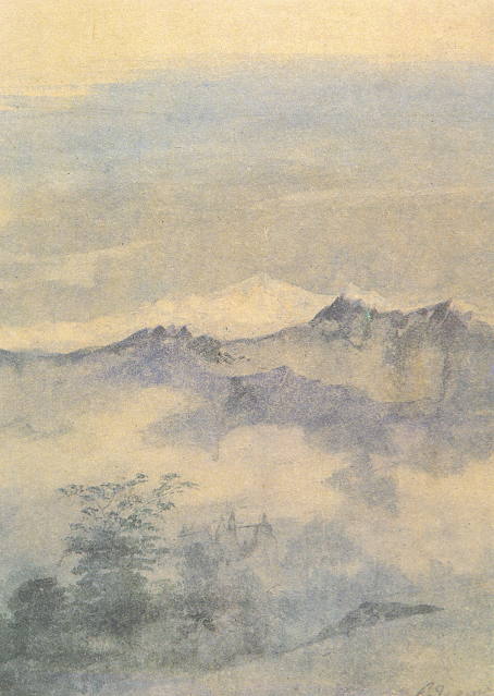
LE KANGCHENJUNGA  PAR   F.W.A. DE FABECK


F. W.A. DE FABECK (1830-1912)


F. W. A. DE FABECK (1830-1912) Kangchenjunga (8 586m) Inde - Népal  In Kintchindjinga Peaks seen from Jelapahar (India) 1890,V&A Museum

F. W. A. DE FABECK (1830-1912)
Kangchenjunga (8 586m)
Inde - Népal

In Kintchindjinga Peaks seen from Jelapahar (India) 1890, Victoria & Albert Museum, Londres

La montagne
Le Kangchenjunga (8586m) (appelé aussi Kanchenjunga, Kangchen Dzö-nga, Kachendzonga, Kintchindjingaou Kangchanfanga) est un sommet de l'Himalaya, sur la frontière indo-népalaise, à l'est du Népal, entre le district de Taplejung et l'État indien du Sikkim où il peut être vu notamment de la capitale Gangtok. Son altitude le classe troisième sommet sur Terre, après l'Everest et le K2, et fait du Kangchenjunga le point culminant de l'Inde. Jusqu'en 1852, il fut considéré comme le plus haut sommet du monde. Le Kangchenjunga est plus qu’un sommet, il forme toute une chaîne de sommets satellites reliés entre eux par des arêtes enneigées ou glacées qui se déploient vers le sud. Malgré sa signification, il ne comporte que quatre sommets majeurs : le sommet sud (8 490 m), le sommet central (8 496 m), le sommet principal au nord (8 586 m), qui est relié au sommet Ouest ou Yalung Kang (8 505 m). À la base de la face est débute le glacier de Zemu, plus grand glacier de l'est de l'Himalaya. Le Kangchenjunga est au centre du massif éponyme situé à cheval entre le Népal et l'Inde (Sikkim). La ligne de crête principale, orientée nord-sud, constitue la frontière entre les deux pays. Les sommets de cette crête sont : le pic Langpo (6 958 m), le Pathibara (7 123 m), le Kirat Chuli (7 365 m), le pic Népal (7 177 m), le Gimmigela Chuli (7 350 m) et le Kabru (7 412 m).
Côté népalais, a été créée l'aire de conservation de Kanchenjunga avec le Drohmo (6 881 m), le Ramthang Chang (6 802 m), le Kangbachen (7 902 m) et le Jannu (7 771 m). Le parc national de Khangchendzonga au Sikkim a comme principaux sommets non frontaliers le Siniolchu (6 888 m), le Simvo (6 812 m) et le Pandim (6 691 m).
En 1848, le colonel Andrew Waugh mesure le Kangchenjunga à 28 178 pieds (8 588 m), qui semble légèrement plus haut que les mesures du Dhaulagiri, qui, lui, était le plus haut sommet avant le calcul du Kangchenjunga. 

 
L'artiste
Les frères Frederick William Alexander de Fabeck (1830-1912) et William Frederick de Fabeck (1834-1906) étaient tous deux employés dans le service médical indien. Frédéric-Guillaume est né le 15 septembre 1830 et a étudié à Paris. Il est devenu licencié du Royal College of Surgeons d'Édimbourg en 1858, année au cours de laquelle il a été nommé chirurgien adjoint du service du Bengale. Il mourut à Alassio, en Italie, le 5 mai 1912. William Frederick devint chirurgien adjoint du service de Madras en 1857, chirurgien en 1869, chirurgien major en 1873 et chirurgien de brigade en 1882. Ses croquis, principalement des détails architecturaux, ont probablement été réalisé, lorsqu'il fut affecté à Jaipur comme professeur à l'École d'Art avant d'en devenir le directeur. Il a également préparé les plans de l'exposition de Jaipur de 1883. Il a servi en Crimée (1854-1855) et participa au siège et à la prise de Sébastopol. Il mourut à Londres le 18 janvier 1906.

______________________________________

2024 - Gravir les montagnes en peinture
Un blog de Francis Rousseau 


Sunday, February 4, 2024

EVEREST/ CHOMOLUNGMA / SAGARMATHA  PEINT PAR  NICHOLAS ROERICH

NICHOLAS ROERICH (1874-1947) Mont Everest / Sagarmatha /Chomolungma (8,848 m - 29,029ft)    Frontière Népal - Chine  In "Remember” from " Country series-Hymalaya", 1924, huile sur toile, Roerich Museum, NewYork

 
NICHOLAS ROERICH (1874-1947)
Mont Everest / Sagarmatha /Chomolungma (8,848 m - 29,029ft) 
  Frontière Népal - Chine

In "Remember” from " Country series-Hymalaya", 1924, huile sur toile, Roerich Museum, NewYork


La montagne
L'Everest //Chomolungma/Sagarmāthā (8,848 m - 29,029ft), à droite dans ce tableau, est une montagne située dans la chaîne de l'Himalaya, à la frontière entre le Népal (province de Koshi) et la Chine (région autonome du Tibet).Il est aperçu par des Européens pour la première fois en 1847 puis, après quelques années d'observations et de calculs, il est identifié comme le plus haut sommet du monde. Son altitude est établie à 8 849 mètres. Cette caractéristique lui vaut d'être baptisé de son nom actuel par les Occidentaux en 1865 en l'honneur de George Everest, arpenteur général des Indes orientales de 1830 à 1843, et, dès les années 1920, de susciter l'intérêt des alpinistes qui se lancent à l'assaut de ses faces. Plusieurs expéditions, en particulier britanniques, se succèdent depuis le versant nord au Tibet. Toutefois, les conditions météorologiques extrêmes font leurs premières victimes, parmi lesquelles George Mallory et Andrew Irvine, en 1924, dont on ne saura probablement jamais avec certitude s'ils ont atteint le sommet. En 1950, le Népal autorise l'accès à la montagne depuis le sud offrant des possibilités d'ascension par l'arête Sud-Est, moins périlleuse. Finalement, trois ans plus tard, Edmund Hillary et Tensing Norgay deviennent les premiers hommes à atteindre le sommet de l'Everest. Dès lors, les exploits en tous genres s'enchaînent, alimentant les fantasmes populaires ; mais, en 1996, une série d'accidents mortels vient rappeler les dangers liés à la montagne, portant de nos jours à plus de 200 le nombre de victimes. Pourtant, le tourisme de masse se généralise, fragilisant ce milieu naturel malgré les créations du parc national de Sagarmatha en 1976 et de la réserve naturelle du Qomolangma en 1988. Ainsi, plus de 14 000 alpinistes ont tenté l'ascension depuis 1922 et plus de 4 000 l'ont réussie, bien aidés, pour la majorité d'entre eux, par les porteurs sherpas et l'utilisation de bouteilles d'oxygène.
La plupart des tentatives d'scension sont effectuées aux mois d'avril et mai avant la mousson d'été. À ce moment de l'année, un changement du courant-jet réduit les vitesses moyennes de vent en haute altitude. D'autres tentatives sont réalisées après la mousson aux mois de septembre et octobre mais la neige tombée pendant la mousson et des conditions météorologiques plus instables rendent l'ascension plus difficile.
Les pionniers laissent désormais la place à la génération du business lucratif. Des dizaines d'opérateurs proposent des expéditions jusqu'au sommet moyennant des sommes pouvant approcher les 50 000 à 70 000 dollars. Ces expéditions commerciales devenues la norme durent environ deux mois, transformant les camps de base en véritables villes éphémères. La démocratisation des technologies permettant une acclimatation à domicile, grâce notamment à des tentes hypoxiques, tend à réduire cette durée.
Point de passage obligé de l'itinéraire classique vers le sommet, le col Sud est devenu une véritable décharge. Peu respectueuses de l'environnement, contrairement  à ce que l'on pourrait penser, les expéditions y abandonnent matériel et déchets qui réapparaissent à la fonte des plaques de neige. Mandatée par le gouvernement népalais et l'UNESCO, une équipe dirigée par l'alpiniste Pierre Royer a entrepris un grand nettoyage au printemps 1993. Au mois de mai, l'expédition, avec une vingtaine de Sherpas, a redescendu huit tonnes de déchets (bouteilles d'oxygène, plastiques, verres, toiles, etc. Le gouvernement népalais essaye de lutter contre cette pollution : chaque expédition est désormais tenue de prouver qu'elle n'a pas abandonné son matériel, sous peine de perdre une caution de 4 000 dollars. En mars 2014, il annonce qu'à partir du mois suivant, tout alpiniste doit redescendre huit kilogrammes de déchets en plus de son propre matériel, sous peine de poursuites. Le tourisme de masse est  le danger qui guette désormais l'Everest surnommé, Le Toit du Monde.

Ecoutez  notre podcast


__________________________________________

2024 - Wandering Vertexes / Gravir les montagnes en peinture
Un blog de Francis Rousseau


Saturday, April 29, 2023

CHOMOLUNGA / MONT EVEREST PEINT PAR COLIN CAMPBELL COOPER

COLIN CAMPBELL COOPER (1856-1937) Mont Everest / Chomolunga (8,848 m - 29,029ft) Chine-Népal  In Himalayas, c. 1920, Huile sur toile, 18 x 22 in. Private collection, Courtesy James Main Fine Arts, Santa Barbara

COLIN CAMPBELL COOPER (1856-1937)
Mont Everest / Chomolunga (8,848 m - 29,029ft)
Chine-Népal

In Himalayas, c. 1920, Huile sur toile, 18 x 22 in. Private collection,
Courtesy James Main Fine Arts, Santa Barbara


La montagne
L'Everest / Chomolungma / Sagarmāthā (8,848 m - 29,029ft) st une montagne située dans la chaîne de l'Himalaya, à la frontière entre le Népal (province de Koshi) et la Chine (région autonome du Tibet). Il est aperçu par des Européens pour la première fois en 1847 puis, après quelques années d'observations et de calculs, il est identifié comme le plus haut sommet du monde. Son altitude est établie à 8 849 mètres. Cette caractéristique lui vaut d'être baptisé de son nom actuel par les Occidentaux en 1865 en l'honneur de George Everest, arpenteur général des Indes orientales de 1830 à 1843, et, dès les années 1920, de susciter l'intérêt des alpinistes qui se lancent à l'assaut de ses faces. Plusieurs expéditions, en particulier britanniques, se succèdent depuis le versant nord au Tibet. Toutefois, les conditions météorologiques extrêmes font leurs premières victimes, parmi lesquelles George Mallory et Andrew Irvine, en 1924, dont on ne saura probablement jamais avec certitude s'ils ont atteint le sommet. En 1950, le Népal autorise l'accès à la montagne depuis le sud offrant des possibilités d'ascension par l'arête Sud-Est, moins périlleuse. Finalement, trois ans plus tard, Edmund Hillary et Tensing Norgay deviennent les premiers hommes à atteindre le sommet de l'Everest. Dès lors, les exploits en tous genres s'enchaînent, alimentant les fantasmes populaires ; mais, en 1996, une série d'accidents mortels vient rappeler les dangers liés à la montagne, portant de nos jours à plus de 200 le nombre de victimes. Pourtant, le tourisme de masse se généralise, fragilisant ce milieu naturel malgré les créations du parc national de Sagarmatha en 1976 et de la réserve naturelle du Qomolangma en 1988. Ainsi, plus de 14 000 alpinistes ont tenté l'ascension depuis 1922 et plus de 4 000 l'ont réussie, bien aidés, pour la majorité d'entre eux, par les porteurs sherpas et l'utilisation de bouteilles d'oxygène.

Le peintre
Colin Campbell Cooper, Jr. est un peintre neo-impressioniste américain né à Philadelphie, en Pennsylvanie  dans une famille d’origine anglo-irlandaise. Sa mère, Emily Williams Cooper, dont les ancêtres ont émigré aux États-Unis depuis Weymouth dans le Dorset en Angleterre, était un peintre amateur d’aquarelle. Son père, le Dr Colin Campbell Cooper - dont le grand-père est venu de Derry, en Irlande- était un chirurgien et passionné par les arts. Étant jeune, Colin fut à son tour inspiré par l'art en particulier après sa participation à l’Exposition universelle de 1876. Ses deux parents, favorables à ses ambitions, l'encourage à devenir un artiste. Il est célèbre pour ses peintures architecturales, en particulier de gratte-ciel à New York, Philadelphie ou Chicago. C’est aussi, un voyageur avide, connu pour ses peintures de monuments européens et asiatiques. Il peint aussi de nombreux paysages naturels, des portraits, des fleurs. Il était aussi enseignant et écrivain. 

_________________________________________

2023 - Wandering Vertexes ....
Errant au-dessus des Sommets Silencieux...
Un blog de Francis Rousseau


Friday, August 19, 2022

THE K2 PEAK PHOTOGRAPHED BY VITTORIO SELLA IN 1909


VITTORIO SELLA (1859-1843)    The K2  peak (8,611m - 28,251 ft)  China - Pakistan border  Photographed during the 1909 expedition  led by Prince Luigi Amedeo, Duke of the Abruzzi

VITTORIO SELLA (1859-1843)  
 The K2  peak (8,611m - 28,251 ft) 
China - Pakistan border

Photographed during the 1909 expedition 
led by Prince Luigi Amedeo, Duke of the Abruzzi 

The artist
Vittorio Sella is a mountain italian climber and photographer who took his passion for mountains from his uncle, Quintino Sella, founder of the Italian Alpine Club.  He accomplished many remarkable climbs in the Alps, the first wintering in the Matterhorn and Mount Rose (1882) and the first winter crossing of Mont Blanc (1888).
He took part in various expeditions outside Italy:
- Three in the Caucasus in 1889, 1890 and 1896 where a summit still bears his name;
- The ascent of Mount Saint Elias in Alaska in 1897;
- Sikkim and Nepal in 1899;
- Possibly climb Mount Stanley in Uganda in 1906 during an expedition to the Rwenzori;
- Recognition at K2  in 1909 (aAbove)
- In Morocco in 1925.
During expeditions in Alaska, Uganda and Karakoram (K2), he accompanied the Duke of Abruzzi, Prince Luigi Amedeo di Savoia.
Sella continues the practice of climbing into his old age, completing his final attempt in the Matterhorn at the age of 76; a climb he had to interrupt the rise following an accident in which one of his guides injured. He died in his hometown during World War II.  His photographic collection is now managed by the Sella Foundation.
His photos mountain are still  considered today to be among the finest ever made.
Jim Curran believes that "Sella remains probably the greatest photographer of the mountain.  His name is synonymous with technical perfection and aesthetic refinement. "
The quality of the pictures of Vittorio Sella is partly explained by the use of a view camera 30 × 40 cm, despite the difficulty of the transportation of such a device, both heavy and fragile in places inaccessible; to be able to transport it safely, he had to make special pieces that can be stored in saddle bags.  His photographs have been widely distributed, either through the press or in the galleries, and were unanimously celebrated; Ansel Adams, who was able to admire thirty-one in an exhibition that was organized at Sella American Sierra Club, said they inspired him "a religious kind of sense of wonder."  Many of his pictures were taken in the mountains for the very first time in the History, which give them a much artistic, historical  but also scientific value ; for example, one could measure the decline in the Rwenzori glaciers in Central Africa.

The mountain 
K2 peak (8,611m - 28,251 ft)  also known as Mount Godwin-Austen or Chhogori is the second highest mountain in the world, after Mount Everest. It is located on the China-Pakistan border between Baltistan, in the Gilgit–Baltistan region of northern Pakistan, and the Taxkorgan Tajik Autonomous County of Xinjiang, China.
The name K2 is derived from the notation used by the Great Trigonometric Survey of British India. Thomas Montgomerie made the first survey of the Karakoram from Mount Haramukh, some 210 km (130 miles) to the south, and sketched the two most prominent peaks, labeling them K1 and K2.
The policy of the Great Trigonometric Survey was to use local names for mountains wherever possible and K1 was found to be known locally as Masherbrum. K2, however, appeared not to have acquired a local name, possibly due to its remoteness. The mountain is not visible from Askole, the last village to the south, or from the nearest habitation to the north, and is only fleetingly glimpsed from the end of the Baltoro Glacier, beyond which few local people would have ventured. The name Chogori, derived from two Balti words, chhogo ("big") and ri ("mountain")  has been suggested as a local name, but evidence for its widespread use is scant. It may have been a compound name invented by Western explorers or simply a bemused reply to the question "What's that called?" It does, however, form the basis for the name Qogir (simplified Chinese: 乔戈里峰; traditional Chinese: 喬戈里峰; pinyin: Qiбogēlǐ Fēng) by which Chinese authorities officially refer to the peak. Other local names have been suggested including Lamba Pahar ("Tall Mountain" in Urdu) and Dapsang, but are not widely used.
Lacking a local name, the name Mount Godwin-Austen was suggested, in honor of Henry Godwin-Austen, an early explorer of the area, and while the name was rejected by the Royal Geographical Society, it was used on several maps, and continues to be used occasionally.
The surveyor's mark, K2, therefore continues to be the name by which the mountain is commonly known. It is now also used in the Balti language, rendered as Kechu or Ketu (Urdu: کے ٹو‎). The Italian climber Fosco Maraini argued in his account of the ascent of Gasherbrum IV that while the name of K2 owes its origin to chance, its clipped, impersonal nature is highly appropriate for so remote and challenging a mountain. He concluded that it was ...
K2 is the highest point of the Karakoram range and the highest point in both Pakistan and Xinjiang.

Friday, January 14, 2022

KANGCHENJUNGA PHOTOGRAPHED IN 1891 BY KURT BOECK

KURT BOECK (1855-1933) Kangchenjunga (8, 538m - 28,169 ft) India, Népal   In Kinchinjunga aus Südosten,  photo, 1891, Privtate coillection


KURT BOECK (1855-1933)
Kangchenjunga (8, 538m - 28,169 ft)
India, Népal 

In Kinchinjunga aus Südosten,  photo, 1891, Private coillection 


The artist
Kurt Karl Alexander Oskar Boeck was a German theater actor, climber, travel writer ans eventually early photographer. He began as an actor but in 1887when he had the opportunity to accompany a research expedition to Asia, especially to Persia and the Caucasus, he could not resist the temptation.
Researching and traveling in lesser-known, far-off lands told him so much that when he returned home from Asia he did not find a commitment that suited his wishes, he turned completely to this interesting profession. First, Boeck undertook in 1890 at his own expense an expedition to the Himalayas, where he took the glacier leader Hans Kerner from Tyrol and drove in the years 1893, 1895 and 1898-1899 again to India to thoroughly get to know the country in all parts. Boeck's lectures in numerous national and international associations on these and his other travels in Burma, China, America, Japan, Siberia, etc., have made him, as well as his articles in magazines, known to the general public.

The mountain
Kangchenjunga (8,586 m (28,169 ft) is the third highest mountain in the world. It lies partly in Nepal and partly in Sikkim, India. Kangchenjunga is the second highest mountain of the Himalayas after Mount Everest. Three of the five peaks – Main, Central and South – are on the border between North Sikkim and Nepal. Two peaks are in the Taplejung District, Nepal.
Kangchenjunga Main is the highest mountain in India, and the easternmost of the mountains higher than 8,000 m (26,000 ft). Until 1852, Kangchenjunga was assumed to be the highest mountain in the world, but calculations based on various readings and measurements made by the Great Trigonometrical Survey of India in 1849 came to the conclusion that Mount Everest, known as Peak XV at the time, was the highest. It is listed int the Eight Thousanders and as Seven Third Summits
Kangchenjunga is the official spelling adopted by Douglas Freshfield, A. M. Kellas, and the Royal Geographical Society that gives the best indication of the Tibetan pronunciation. Freshfield referred to the spelling used by the Indian Government since the late 19th century. There are a number of alternative spellings including Kangchendzцnga, Khangchendzonga, and Kanchenjunga. Local Lhopo people believe that the treasures are hidden but reveal to the devout when the world is in peril; the treasures comprise salt, gold, turquoise and precious stones, sacred scriptures, invincible armor or ammunition, grain and medicine. Kangchenjunga's name in the Limbu language is Senjelungma or Seseylungma, and is believed to be an abode of the omnipotent goddess Yuma Sammang.
It rises in a section of the Himalayas called Kangchenjunga Himal that is limited in the west by the Tamur River, in the north by the Lhonak Chu and Jongsang La, and in the east by the Teesta River. It lies about 128 km (80 mi) east of Mount Everest.
Allowing for further verification of all calculations, it was officially announced in 1856 that
Kangchenjunga was first climbed on 25 May 1955 by Joe Brown and George Band, who were part of a British expedition. They stopped short of the summit as per the promise given to the Chogyal that the top of the mountain would remain inviolate. Every climber or climbing group that has reached the summit has followed this tradition. Other members of this expedition included John Angelo Jackson and Tom Mackinon. In May 1979, Doug Scott, Peter Boardman and Joe Tasker established a new route on the North Ridge their third ascent which was the first one ever made without oxygen.
In 1983, Pierre Beghin made the first solo ascent accomplished without the use of supplemental oxygen. In 1992, Wanda Rutkiewicz was the first woman in the world to ascend and descend K2 and a world-renowned Polish climber, died after she insisted on waiting for an incoming storm to pass, which she did not survive. In 1998, Ginette Harrison was the first woman who climbed Kangchenjunga North face ; Gerlinde Kaltenbrunner, an Austrian mountaineer, was the second woman to reach the summit in 2006. In May 2014, the Bulgarian diabetic climber Boyan Petrov reached the peak without the use of supplemental oxygen

_______________________________
2022 - Wandering Vertexes...
by Francis Rousseau

Wednesday, February 10, 2021

KANGCHENJUNGA PAINTED BY GAGANENDRANATH TAGORE


https://wanderingvertexes.blogspot.com/2021/02/kangchenjunga-painted-by-gaganendranath.html

GAGANENDRANATH  TAGORE  (1867-1938)
Kangchenjunga (8, 538m - 28,169 ft)
India, Népal

In Kangchenjunga, watercolor,  National Gallery of Modern Art, New Delhi


The painter
Gaganendranath Tagore was an Indian painter and cartoonist of the Bengal school. Along with his brother Abanindranath Tagore, he was counted as one of the earliest modern artists in India. Gaganendranath Tagore was born at Jorasanko into a family whose creativity defined Bengal's cultural life. Gaganendranath was the eldest son of Gunendranath Tagore, grandson of Girindranath Tagore and a great-grandson of Prince Dwarkanath Tagore. His brother Abanindranath was a pioneer and leading exponent of the Bengal School of Art. He was a nephew of the poet Rabindranath Tagore and the paternal great-grandfather of actress Sharmila Tagore. Gaganendranath received no formal education but trained under the watercolourist Harinarayan Bandopadhyay. In 1907, along with his brother Abanindranath, he founded the Indian Society of Oriental Art which later published the influential journal Rupam. Between 1906 and 1910, the artist studied and assimilated Japanese brush techniques and the influence of Far Eastern art into his own work, as demonstrated by his illustrations for Rabindranath Tagore's autobiography Jeevansmriti (1912). He went on to develop his own approach in his Chaitanya and Pilgrim series. Gaganendranath eventually abandoned the revivalism of the Bengal School and took up caricature. The Modern Review published many of his cartoons in 1917. From 1917 onwards, his satirical lithographs appeared in a series of books, including Play of Opposites, Realm of the Absurd and Reform Screams.
Between 1920 and 1925, Gaganendranath pioneered experiments in modernist painting.  Partha Mitter describes him as "the only Indian painter before the 1940s who made use of the language and syntax of Cubism in his painting". From 1925 onwards, the artist developed a complex post-cubist style.

The mountain
Kangchenjunga (8,586 m - 28,169 ft) is the third highest mountain in the world. It lies partly in Nepal and partly in Sikkim, India. Kangchenjunga is the second highest mountain of the Himalayas after Mount Everest. Three of the five peaks – Main, Central and South – are on the border between North Sikkim and Nepal. Two peaks are in the Taplejung District, Nepal.
Kangchenjunga Main is the highest mountain in India, and the easternmost of the mountains higher than 8,000 m (26,000 ft).
Until 1852, Kangchenjunga was assumed to be the highest mountain in the world, but calculations based on various readings and measurements made by the Great Trigonometrical Survey of India in 1849 came to the conclusion that Mount Everest., known as Peak XV at the time, was the highest.
It is listed int the Eight Thousanders and as Seven Third Summits
Kangchenjunga is the official spelling adopted by Douglas Freshfield, A. M. Kellas, and the Royal Geographical Society that gives the best indication of the Tibetan pronunciation. Freshfield referred to the spelling used by the Indian Government since the late 19th century. There are a number of alternative spellings including Kangchendzцnga, Khangchendzonga, and Kanchenjunga.
Local Lhopo people believe that the treasures are hidden but reveal to the devout when the world is in peril; the treasures comprise salt, gold, turquoise and precious stones, sacred scriptures, invincible armor or ammunition, grain and medicine. Kangchenjunga's name in the Limbu language is Senjelungma or Seseylungma, and is believed to be an abode of the omnipotent goddess Yuma Sammang.
It rises in a section of the Himalayas called Kangchenjunga Himal that is limited in the west by the Tamur River, in the north by the Lhonak Chu and Jongsang La, and in the east by the Teesta River. It lies about 128 km (80 mi) east of Mount Everest.
Allowing for further verification of all calculations, it was officially announced in 1856 that
Kangchenjunga was first climbed on 25 May 1955 by Joe Brown and George Band, who were part of a British expedition. They stopped short of the summit as per the promise given to the Chogyal that the top of the mountain would remain inviolate. Every climber or climbing group that has reached the summit has followed this tradition...

____________________________

2021 - Wandering Vertexes...
by Francis Rousseau

Monday, January 4, 2021

NANGA PARBAT PAINTED BY NICHOLAS ROERICH


https://wanderingvertexes.blogspot.com/2021/01/nanga-parbat-painted-by-nicholas-roerich.html
 
 
NICHOLAS ROERICH (1874-1947),
Nanga Parbat (8,126 m - 26,660 ft)
Pakistan

 In Nanga Parbat, oil on canvas, 1940, Nicolas Roerich  Museum, NYC


The mountain
Nanga Parbat (8,126 metres (26,660 ft) locally known as Diamer, is the ninth highest mountain in the world . Located in the Diamer District of Gilgit-Baltistan region, Pakistan, Nanga Parbat is the western anchor of the Himalayas. ] The name Nanga Parbat is derived from the Sanskrit words nagna and parvata which together mean "Naked Mountain".  The mountain is locally known by its Tibetan name Diamer or Deo Mir, meaning "huge mountain".
Nanga Parbat is one of the 14 eight-thousanders. An immense, dramatic peak rising far above its surrounding terrain, Nanga Parbat is known to be a difficult climb.   Nanga Parbat is one of only two peaks on Earth that rank in the top twenty of both the highest mountains in the world, and the most prominent peaks in the world, ranking ninth and fourteenth respectively. The other is Mount Everest, which is first on both lists.  Nanga Parbat along with Namcha Barwa on the Tibetan Plateau mark the west and east ends of the Himalayas.

The painter
Nicholas Roerich known also as Nikolai Konstantinovich Rerikh (Никола́й Константи́нович Ре́рих) is quite an important figure of mountain paintings in the early 20th century. He was a Russian painter, writer, archaeologist, theosophist, perceived by some in Russia as an enlightener, philosopher, and public figure. In his youth was he was quite influenced by a movement in Russian society around the occult and was interested in hypnosis and other spiritual practices. His paintings are said to have hypnotic expression.
More about the painter =>

__________________________________________

2021 - Wandering Vertexes / Mountain paintings
By F rancis Rousseau

_______________________________

2021 - Wandering Vertexes...
by Francis Rousseau

Tuesday, March 10, 2020

KANGCHENJUNGA (3) PAINTED BY NICHOLAS ROERICH


NICHOLAS ROERICH (1874-1947),
Kangchenjunga (8, 538m - 28,169 ft)
India, Népal

In Kangchenjunga mountains lakes 1931, tempera on canvas, Private collection

The mountain
Kangchenjunga (8,586 m - 28,169 ft) is the third highest mountain in the world. It lies partly in Nepal and partly in Sikkim, India. Kangchenjunga is the second highest mountain of the Himalayas after Mount Everest. Three of the five peaks – Main, Central and South – are on the border between North Sikkim and Nepal. Two peaks are in the Taplejung District, Nepal.
Kangchenjunga Main is the highest mountain in India, and the easternmost of the mountains higher than 8,000 m (26,000 ft).
Until 1852, Kangchenjunga was assumed to be the highest mountain in the world, but calculations based on various readings and measurements made by the Great Trigonometrical Survey of India in 1849 came to the conclusion that Mount Everest., known as Peak XV at the time, was the highest.
It is listed int the Eight Thousanders and as Seven Third Summits
Kangchenjunga is the official spelling adopted by Douglas Freshfield, A. M. Kellas, and the Royal Geographical Society that gives the best indication of the Tibetan pronunciation. Freshfield referred to the spelling used by the Indian Government since the late 19th century. There are a number of alternative spellings including Kangchendzцnga, Khangchendzonga, and Kanchenjunga.
Local Lhopo people believe that the treasures are hidden but reveal to the devout when the world is in peril; the treasures comprise salt, gold, turquoise and precious stones, sacred scriptures, invincible armor or ammunition, grain and medicine. Kangchenjunga's name in the Limbu language is Senjelungma or Seseylungma, and is believed to be an abode of the omnipotent goddess Yuma Sammang.
It rises in a section of the Himalayas called Kangchenjunga Himal that is limited in the west by the Tamur River, in the north by the Lhonak Chu and Jongsang La, and in the east by the Teesta River. It lies about 128 km (80 mi) east of Mount Everest.
Allowing for further verification of all calculations, it was officially announced in 1856 that
Kangchenjunga was first climbed on 25 May 1955 by Joe Brown and George Band, who were part of a British expedition. They stopped short of the summit as per the promise given to the Chogyal that the top of the mountain would remain inviolate. Every climber or climbing group that has reached the summit has followed this tradition...

The painter
Nicholas Roerich known also as Nikolai Konstantinovich Rerikh (Никола́й Константи́нович Ре́рих) is quite an important figure of mountain paintings in the early 20th century. He was a Russian painter, writer, archaeologist, theosophist, perceived by some in Russia as an enlightener, philosopher, and public figure. In his youth was he was quite influenced by a movement in Russian society around the occult and was interested in hypnosis and other spiritual practices. His paintings are said to have hypnotic expression.
More about the painter = >

_______________________________ 

2020 - Wandering Vertexes...
by Francis Rousseau

Saturday, January 25, 2020

KANGCHENJUNGA (2) PAINTED BY NICHOLAS ROERICH


NICHOLAS ROERICH (1874-1947),
Kangchenjunga (8, 538m - 28,169 ft)
India, Népal

In Kangchenjunga at sunset  1944, tempera on canvas, Private collection

The mountain
Kangchenjunga (8,586 m - 28,169 ft) is the third highest mountain in the world. It lies partly in Nepal and partly in Sikkim, India. Kangchenjunga is the second highest mountain of the Himalayas after Mount Everest. Three of the five peaks – Main, Central and South – are on the border between North Sikkim and Nepal. Two peaks are in the Taplejung District, Nepal.
Kangchenjunga Main is the highest mountain in India, and the easternmost of the mountains higher than 8,000 m (26,000 ft).
Until 1852, Kangchenjunga was assumed to be the highest mountain in the world, but calculations based on various readings and measurements made by the Great Trigonometrical Survey of India in 1849 came to the conclusion that Mount Everest., known as Peak XV at the time, was the highest.
It is listed int the Eight Thousanders and as Seven Third Summits
Kangchenjunga is the official spelling adopted by Douglas Freshfield, A. M. Kellas, and the Royal Geographical Society that gives the best indication of the Tibetan pronunciation. Freshfield referred to the spelling used by the Indian Government since the late 19th century. There are a number of alternative spellings including Kangchendzцnga, Khangchendzonga, and Kanchenjunga.
Local Lhopo people believe that the treasures are hidden but reveal to the devout when the world is in peril; the treasures comprise salt, gold, turquoise and precious stones, sacred scriptures, invincible armor or ammunition, grain and medicine. Kangchenjunga's name in the Limbu language is Senjelungma or Seseylungma, and is believed to be an abode of the omnipotent goddess Yuma Sammang.
It rises in a section of the Himalayas called Kangchenjunga Himal that is limited in the west by the Tamur River, in the north by the Lhonak Chu and Jongsang La, and in the east by the Teesta River. It lies about 128 km (80 mi) east of Mount Everest.
Allowing for further verification of all calculations, it was officially announced in 1856 that
Kangchenjunga was first climbed on 25 May 1955 by Joe Brown and George Band, who were part of a British expedition. They stopped short of the summit as per the promise given to the Chogyal that the top of the mountain would remain inviolate. Every climber or climbing group that has reached the summit has followed this tradition...

The painter
Nicholas Roerich known also as Nikolai Konstantinovich Rerikh (Никола́й Константи́нович Ре́рих) is quite an important figure of mountain paintings in the early 20th century. He was a Russian painter, writer, archaeologist, theosophist, perceived by some in Russia as an enlightener, philosopher, and public figure. In his youth was he was quite influenced by a movement in Russian society around the occult and was interested in hypnosis and other spiritual practices. His paintings are said to have hypnotic expression.
More about the painter = >

_______________________________ 

2020 - Wandering Vertexes...
by Francis Rousseau

Thursday, December 26, 2019

KANGJENCHUNGA & PANDIM BY VASILY VERESHCHAGIN


VASILY VERESHCHAGIN (1842-1904)
Kangchenjunga (8, 538m - 28,169 ft) 
 Mount Pandim (6, 691 m - 21, 952 ft)
India, Népal

In Kanchinjinga, Pandim and other Mountains in the Clouds, oil on canvas, 46.3 x 64.7 cm, 1879, Private collection, Christie's


About this painting,
Very sumilar to the   Sunset in the Himalayas painted  by  Vereshchagin  the same year in 1879, that painting is  often confused with. If the impressionist technic of painting,  the frame (vegetation in the foreground) and  the colours are the same,  the view is not the same. 

About the mountains
 Kangchenjunga   (8,586 m - 28,169 ft) is the third highest mountain in the world. It lies partly in Nepal and partly in Sikkim, India. Kangchenjunga is the second highest mountain of the Himalayas after Mount Everest. Three of the five peaks – Main, Central and South – are on the border between North Sikkim and Nepal. Two peaks are in the Taplejung District, Nepal.
Kangchenjunga Main is the highest mountain in India, and the easternmost of the mountains higher than 8,000 m (26,000 ft).
Until 1852, Kangchenjunga was assumed to be the highest mountain in the world, but calculations based on various readings and measurements made by the Great Trigonometrical Survey of India in 1849 came to the conclusion that Mount Everest., known as Peak XV at the time, was the highest. It is listed int the Eight Thousanders and as Seven Third Summits...
Mount Pandim (6,691 m - 21,952 ft) is a Himalayan mountain located in the Sikkim province, India. It is considered often as a part of the Kangchenjunga mountains. Kangchenjunga (sometimes spelled Kanchenjunga), is the third highest mountain in the world, and lies partly in Nepal and partly in Sikkim (India).  It lies about 128 km east of Mount Everest.


The painter
Vasily Vasilyevich Vereshchagin (Васи́лий Васи́льевич Вереща́гин) transcribed in English as "Basil Verestchagin", was one of the most famous Russian war artists and one of the first Russian artists to be widely recognized abroad. The graphic nature of his realist scenes led many of them to never be printed or exhibited. In 1864 he proceeded to Paris, where he studied under Jean-Léon Gérôme, though he dissented widely from his master's methods. In the Paris Salon of 1866 he exhibited a drawing of Dukhobors chanting their Psalms. In the next year he was invited to accompany General Konstantin Kaufman's expedition to Turkestan. He was an indefatigable traveler, returning to St. Petersburg in late 1868, to Paris in 1869, back to St. Petersburg later in the year, and then back to Turkestan at the end 1869 via Siberia. In 1871, he established an atelier in Munich, and made a solo exhibition of his works at the Crystal Palace in London in 1873.
In late 1874, he departed for an extensive tour of the Himalayas, India and Tibet, spending over two years in travel. He returned to Paris in late 1876
After the war, Vereshchagin settled at Munich, where he produced his war pictures so rapidly that he was freely accused of employing assistants. The sensational subjects of his pictures, and their didactic aim, the promotion of peace by a representation of the horrors of war, attracted a large section of the public not usually interested in art to the series of exhibitions of his pictures in Paris in 1881 and subsequently in London, Berlin, Dresden, Vienna and other cities.
By the late 19th century, Vereshchagin had gained popularity not only in Russia, but also abroad and his name never left the pages of the European and American press. From his earliest works, unlike most contemporary battle pieces depicting war as a kind of parade, Vereshchagin graphically depicted the horrors of war. "I loved the sun all my life, and wanted to paint sunshine. When I happened to see warfare and say what I thought about it, I rejoiced that I would be able to devote myself to the sun once again. But the fury of war continued to pursue me," Vereshchagin wrote. One day, in 1882, Vereshchagin’s exhibition in Berlin was visited by German Field Marshal Helmuth von Moltke the Elder. Vereshchagin brought Moltke to his painting The Apotheosis of War. The picture evoked a sort of confusion in the Field Marshal. After his visit to the exhibition, Moltke issued an order forbidding German soldiers to visit it. The Austrian war minister did the same. He also declined the artist's offer to let Austrian officers see his pictures at the 1881 exhibition in Vienna free of charge.

___________________________________
Wandering Vertexes 2019
A blog by Francis Rousseau

Wednesday, December 25, 2019

MOUNT EVEREST BY RENÉ MAGRITTE


RENÉ  MAGRITTE (1898-1967)
Mount Everest or Sagarmatha or Chomolunga (8,848 m - 29,029ft) 
  Nepal - China border 

In Le Toit du Monde (The World Roof), 1926, oil on canvas, Private collection 

 About this painting
Le Toit du Monde meaning the The World Roof, like most of the René Magritte Panitngs can't be explained. René Magritte described his paintings as "visible images which conceal nothing; they evoke mystery and, indeed, when one sees one of my pictures, one asks oneself this simple question, 'What does that mean?'. It does not mean anything, because mystery means nothing either, it is unknowable."
The only thing we may noticed is the fact the shape of the mountain he painted is indeed the shape of Mount Everest, the highest summit on earth, nicknamed for that reason The World Roof (Le Toit du Monde).
The black veins that appear on the mountain, as well as the other elements of the composition cannot be explained and are part of that "unknowable" poetry of mystery described above.

The painter
René François Ghislain Magritte  was a Belgian Surrealist artist. He became well known for creating a number of witty and thought-provoking images. Often depicting ordinary objects in an unusual context, his work is known for challenging observers' preconditioned perceptions of reality. His imagery has influenced pop art, minimalist art and conceptual art.
The use of objects as other than what they seem is typified in his painting, The Treachery of Images (La trahison des images), which shows a pipe that looks as though it is a model for a tobacco store advertisement. Magritte painted below the pipe "Ceci n'est pas une pipe" ("This is not a pipe"), which seems a contradiction, but is actually true: the painting is not a pipe, it is an image of a pipe. It does not "satisfy emotionally"—when Magritte was once asked about this image, he replied that of course it was not a pipe, just try to fill it with tobacco ".
Magritte's use of ordinary objects in unfamiliar spaces is joined to his desire to create poetic imagery. He described the act of painting as "the art of putting colors side by side in such a way that their real aspect is effaced, so that familiar objects—the sky, people, trees, mountains, furniture, the stars, solid structures, graffiti—become united in a single poetically disciplined image. The poetry of this image dispenses with any symbolic significance, old or new."
Magritte's constant play with reality and illusion has been attributed to the early death of his mother. Psychoanalysts who have examined bereaved children have hypothesized that Magritte's back and forth play with reality and illusion reflects his "constant shifting back and forth from what he wishes—'mother is alive'—to what he knows—'mother is dead'

The mountain
Mount Everest (8,848 m - 29,029ft), also known in Nepal as Sagarmāthā and in Tibet as Chomolungma, is Earth's highest mountain.  This is teh reason it was nicknamend "The World Roof " like in the painitng aboce.
 It is located in the Mahalangur mountain range in Nepal and Tibet. The international border between China (Tibet Autonomous Region) and Nepal runs across Everest's precise summit point. Its massif includes neighbouring peaks Lhotse (8,516 m -27,940 ft); Nuptse (7,855 m -25,771 ft) and Changtse (7,580 m -24,870 ft).
In 1856, the Great Trigonometrical Survey of India established the first published height of Everest, then known as Peak XV, at (8,840 m -29,002 ft). The current official height of (8,848 m -29,029 ft) as recognised by China and Nepal was established by a 1955 Indian survey and subsequently confirmed by a Chinese survey in 1975. In 1865, Everest was given its official English name by the Royal Geographical Society upon a recommendation by Andrew Waugh, the British Surveyor General of India. As there appeared to be several different local names, Waugh chose to name the mountain after his predecessor in the post, Sir George Everest, despite George Everest's objections.
More about Mount Everest  

______________________________________

2019 - Wandering Vertexes...
by Francis Rousseau 

Tuesday, November 12, 2019

EVEREST & LHOTSE BY ISABELLE SCHEIBLI


ISABELLE SCHEIBLI (bn.1949),
Mount Everest / Sagarmatha / Chomolunga (8,848 m - 29,029ft) 
Lhotse (8, 516m - 27, 940ft) 
China (Tibet) / Nepal

In Everest, and Lhotse, watercolor

The mountains 
Mount Everest (8,848 m - 29,029ft), also known in Nepal as Sagarmāthā and in Tibet as Chomolungma, is Earth's highest mountain. It is located in the Mahalangur mountain range in Nepal and Tibet. The international border between China (Tibet Autonomous Region) and Nepal runs across Everest's precise summit point. Its massif includes neighbouring peaks Lhotse (8,516 m -27,940 ft); Nuptse (7,855 m -25,771 ft) and Changtse (7,580 m -24,870 ft).
In 1856, the Great Trigonometrical Survey of India established the first published height of Everest, then known as Peak XV, at (8,840 m -29,002 ft). The current official height of (8,848 m -29,029 ft) as recognised by China and Nepal was established by a 1955 Indian survey and subsequently confirmed by a Chinese survey in 1975. In 1865, Everest was given its official English name by the Royal Geographical Society upon a recommendation by Andrew Waugh, the British Surveyor General of India. As there appeared to be several different local names, Waugh chose to name the mountain after his predecessor in the post, Sir George Everest, despite George Everest's objections.
Mount Everest attracts many climbers, some of them highly experienced mountaineers. There are two main climbing routes: one approaching the summit from the southeast in Nepal (known as the standard route) and the other from the north in Tibet. While not posing substantial technical climbing challenges on the standard route, Everest presents dangers such as altitude sickness, weather, wind as well as significant objective hazards from avalanches and the Khumbu Icefall. As of 2016, there are well over 200 corpses still on the mountain, with some of them even serving as landmarks.More informations on Everes

Lhotse (8, 516 m - 27, 940 ft), which means “South Peak” in Tibetan is the fourth highest mountain in the world after Mount Everest, K2, and Kangchenjunga. Part of the Everest massif, Lhotse is connected to the latter peak via the South Col.  In addition to the main summit, the mountain comprises the smaller peaks Lhotse Middle (8,414 m- 27,605 ft) and Lhotse Shar (8,383 m - 27,503 ft). The summit is on the border between Tibet and the Khumbu region of Nepal.
The main summit of Lhotse was first climbed on May 18, 1956, by the Swiss team of Ernst Reiss and Fritz Luchsinger from the Swiss Mount Everest/Lhotse Expedition. On May 12, 1970, Sepp Mayerl and Rolf Walter of Austria made the first ascent of Lhotse Shar. Lhotse Middle remained, for a long time, the highest unclimbed named point on Earth; on May 23, 2001, its first ascent was made by Eugeny Vinogradsky, Sergei Timofeev, Alexei Bolotov and Petr Kuznetsov of a Russian expedition.
By December 2008, 371 climbers had summitted Lhotse while 20 died during their attempt.
Lhotse was not summited in 2014, 2015, or 2016 due to a series of incidents, however, it was summited again in May 2017. 

The artist
Isabelle Scheibli (bn. 1949) is a french journalist, screenwriter, essayist and watercolorist, passionate about mountains. She is the author of the novel "Gaspard de la Meije" published in 1984. As a journalist she worked for several mountains magazines such as "Vertical" or "Montagne Magazine". She wrote several films scenarii related to the mountain such as "Le passe montagne" (1996), "Jours Blancs" (1990) or "Gaspard de la Meije" (1984) based on her novel, winner of a prize in the Festivals of Trent and of Les Diablerets, and also recompensed by the La Fondation de France. As a watercolorist, she illustrated three albums from the Carrés de France collection for Editions Equinox, about the Haute Savoie (2002), the Savoie (2003), the Drôme Provençale (2008).
Isabelle Scheibli made several voyages to Patagonia and Antarctica, which are her favorite places on earth. She doesn’t always paint in situ, due to the extreme conditions in these lands, especially speaking about watercolors! She often paints watertcolors in her studio from her drawings or photos, she realised herself in the Antarctic. About those voyages she wrote :
«Painting the glacial world is a long-term process. To accompany close alpinists and Himalayists in their expeditions, I have often been in the mountains, in the Alps, in Nepal and in Tibet. The peaks have become a privileged motive. In 2014, I had the opportunity to go to Patagonia, to follow the coast of the Beagle Channel on a sailboat and to go to the foot of the glaciers of Tierra del Fuego. It was a very violent aesthetic shock. Here the conditions did not always allow me to paint as I wished. When I returned I undertook a work in my atelier from the many drawings, watercolors and photos that I had brought back. The dimension of immensity quickly led me to paint in a large format, which I had never done before. In 2016, I set out on a sailboat to approach the absolute quintessence of the glacier, an entire continent of ice, Antarctica. I had somewhat underestimated the navigation part of this trip but the discovery of this icy pole was a glare. Once again I brought back watercolors stolen between two gusts, many drawings and photos. And I got to work on the way back, immersing myself completely »

__________________________________________
2019 - Wandering Vertexes...
by Francis Rousseau

Saturday, October 19, 2019

KANGCHENJUNGA AT NIGHT BY NICHOLAS ROERICH


https://wanderingvertexes.blogspot.com/2019/10/kangchenjunga-at-night-by-nicholas.html 

NICHOLAS ROERICH (1874-1947), 
Kangchenjunga (8, 538m - 28,169 ft) 
India, Népal

 In  Himalayas at night, Sikkim, 1928-29, tempera on canvas, Private collection

The mountain 
 Kangchenjunga (8,586 m - 28,169 ft) is the  third highest mountain in the world. It  lies partly in Nepal and partly in Sikkim, India.  Kangchenjunga is the second highest mountain of the Himalayas after Mount Everest. Three of the five peaks – Main, Central and South – are on the border between North Sikkim and Nepal. Two peaks are in the Taplejung District, Nepal.
Kangchenjunga Main is the highest mountain in India, and the easternmost of the mountains higher than 8,000 m (26,000 ft).  
Until 1852, Kangchenjunga was assumed to be the highest mountain in the world, but calculations based on various readings and measurements made by the Great Trigonometrical Survey of India in 1849 came to the conclusion that Mount Everest., known as Peak XV at the time, was the highest.  
It is listed int the  Eight Thousanders and as Seven Third Summits
Kangchenjunga is the official spelling adopted by Douglas Freshfield, A. M. Kellas, and the Royal Geographical Society that gives the best indication of the Tibetan pronunciation. Freshfield referred to the spelling used by the Indian Government since the late 19th century. There are a number of alternative spellings including Kangchendzцnga, Khangchendzonga, and Kanchenjunga.  
Local Lhopo people believe that the treasures are hidden but reveal to the devout when the world is in peril; the treasures comprise salt, gold, turquoise and precious stones, sacred scriptures, invincible armor or ammunition, grain and medicine. Kangchenjunga's name in the Limbu language is Senjelungma or Seseylungma, and is believed to be an abode of the omnipotent goddess Yuma Sammang.
It rises in a section of the Himalayas called Kangchenjunga Himal that is limited in the west by the Tamur River, in the north by the Lhonak Chu and Jongsang La, and in the east by the Teesta River. It lies about 128 km (80 mi) east of Mount Everest.
Allowing for further verification of all calculations, it was officially announced in 1856 that
Kangchenjunga was first climbed on 25 May 1955 by Joe Brown and George Band, who were part of a British expedition. They stopped short of the summit as per the promise given to the Chogyal that the top of the mountain would remain inviolate. Every climber or climbing group that has reached the summit has followed this tradition...

The painter 
Nicholas Roerich known also as Nikolai Konstantinovich Rerikh (Никола́й Константи́нович Ре́рих) is quite an important figure of mountain paintings in the early 20th century. He was a Russian painter, writer, archaeologist, theosophist, perceived by some in Russia as an enlightener, philosopher, and public figure. In his youth was he was quite influenced by a movement in Russian society around the occult and was interested in hypnosis and other spiritual practices. His paintings are said to have hypnotic expression.

_______________________________
2019 - Wandering Vertexes...

by Francis Rousseau 

Monday, September 30, 2019

K2 PEAK PAINTED BY NICHOLAS ROERICH


NICHOLAS ROERICH (1874-1947)
The K2 peak (8,611m - 28,251 ft) 
China - Pakistan border

In Himalayas. Rain, 1933, tempera. Nicholas Roerich Museum, NYC


The mountain 

K2 peak (8,611m - 28,251 ft)  also known as Mount Godwin-Austen or Chhogori is the second highest mountain in the world, after Mount Everest. It is located on the China-Pakistan border between Baltistan, in the Gilgit–Baltistan region of northern Pakistan, and the Taxkorgan Tajik Autonomous County of Xinjiang, China.
The name K2 is derived from the notation used by the Great Trigonometric Survey of British India. Thomas Montgomerie made the first survey of the Karakoram from Mount Haramukh, some 210 km (130 miles) to the south, and sketched the two most prominent peaks, labeling them K1 and K2.
The policy of the Great Trigonometric Survey was to use local names for mountains wherever possible and K1 was found to be known locally as Masherbrum. K2, however, appeared not to have acquired a local name, possibly due to its remoteness. The mountain is not visible from Askole, the last village to the south, or from the nearest habitation to the north, and is only fleetingly glimpsed from the end of the Baltoro Glacier, beyond which few local people would have ventured. The name Chogori, derived from two Balti words, chhogo ("big") and ri ("mountain") has been suggested as a local name, but evidence for its widespread use is scant. It may have been a compound name invented by Western explorers or simply a bemused reply to the question "What's that called?" It does, however, form the basis for the name Qogir (simplified Chinese: 乔戈里峰; traditional Chinese: 喬戈里峰; pinyin: Qiбogēlǐ Fēng) by which Chinese authorities officially refer to the peak. Other local names have been suggested including Lamba Pahar ("Tall Mountain" in Urdu) and Dapsang, but are not widely used.

The painter 
Nicholas Roerich known also as Nikolai Konstantinovich Rerikh (Никола́й Константи́нович Ре́рих) is quite an important figure of mountain paintings in the early 20th century. He was a Russian painter, writer, archaeologist, theosophist, perceived by some in Russia as an enlightener, philosopher, and public figure. In his youth was he was quite influenced by a movement in Russian society around the occult and was interested in hypnosis and other spiritual practices. His paintings are said to have hypnotic expression.

_______________________________

2019 - Wandering Vertexes...
by Francis Rousseau 


Sunday, September 15, 2019

MOUNT EVEREST / CHOMOLUNGA PAINTED BY VASILY VERESHCHAGIN


VASILY VERESHCHAGIN (1842-1904)
Mount Everest or Sagarmatha or Chomolunga (8,848 m - 29,029ft) 
China (Tibet) / Nepal 

In Sunset in the Himalayas,  oil on canvas, 1879

The mountain
Mount Everest (8,848 m - 29,029ft), also known in Nepal as Sagarmāthā and in Tibet as Chomolungma, is Earth's highest mountain. It is located in the Mahalangur mountain range in Nepal and Tibet. The international border between China (Tibet Autonomous Region) and Nepal runs across Everest's precise summit point. Its massif includes neighbouring peaks Lhotse (8,516 m -27,940 ft); Nuptse (7,855 m -25,771 ft) and Changtse (7,580 m -24,870 ft).
In 1856, the Great Trigonometrical Survey of India established the first published height of Everest, then known as Peak XV, at (8,840 m -29,002 ft). The current official height of (8,848 m -29,029 ft) as recognised by China and Nepal was established by a 1955 Indian survey and subsequently confirmed by a Chinese survey in 1975. In 1865, Everest was given its official English name by the Royal Geographical Society upon a recommendation by Andrew Waugh, the British Surveyor General of India. As there appeared to be several different local names, Waugh chose to name the mountain after his predecessor in the post, Sir George Everest, despite George Everest's objections.
Mount Everest attracts many climbers, some of them highly experienced mountaineers. There are two main climbing routes: one approaching the summit from the southeast in Nepal (known as the standard route) and the other from the north in Tibet. While not posing substantial technical climbing challenges on the standard route, Everest presents dangers such as altitude sickness, weather, wind as well as significant objective hazards from avalanches and the Khumbu Icefall. As of 2016, there are well over 200 corpses still on the mountain, with some of them even serving as landmarks.
The first recorded efforts to reach Everest's summit were made by British mountaineers. With Nepal not allowing foreigners into the country at the time, the British made several attempts on the north ridge route from the Tibetan side. After the first reconnaissance expedition by the British in 1921 reached 7,000 m - 22,970 ft) on the North Col, the 1922 expedition pushed the North ridge route up to 8,320 m - 27,300 ft) marking the first time a human had climbed above 8,000 m - 26,247 ft). Tragedy struck on the descent from the North col when seven porters were killed in an avalanche. The 1924 expedition resulted in the greatest mystery on Everest to this day: George Mallory and Andrew Irvine made a final summit attempt on 8 June but never returned, sparking debate as to whether they were the first to reach the top. They had been spotted high on the mountain that day but disappeared in the clouds, never to be seen again, until Mallory's body was found in 1999 at 8,155 m (26,755 ft) on the North face. Tenzing Norgay and Edmund Hillary made the first official ascent of Everest in 1953 using the southeast ridge route. Tenzing had reached 8,595 m - 28,199 ft) the previous year as a member of the 1952 Swiss expedition. The Chinese mountaineering team of Wang Fuzhou, Gonpo and Qu Yinhua made the first reported ascent of the peak from the North Ridge on 25 May 1960.
Mount Everest is one of the Seven Summit, which includes the highest mountains of each of the seven continents. Summiting all of them is regarded as a mountaineering challenge, first achieved on April 30, 1985 by Richard Bass.
The 7 summits (which are obviously 8 !)... are :
Mount Everest (8,848 m), Aconcagua (6,961m), Mt Denali or Mc Kinley (6,194 m), Kilimandjaro (5,895 m), Mt Elbrus (5,642 m), Vinson Massif (4,892 m), Mt Blanc (4,807 m) and Mount Kosciuszko (2,228 m) in Australia.

The painter
Vasily Vasilyevich Vereshchagin (Васи́лий Васи́льевич Вереща́гин) transcribed in English as "Basil Verestchagin", was one of the most famous Russian war artists and one of the first Russian artists to be widely recognized abroad. The graphic nature of his realist scenes led many of them to never be printed or exhibited. In 1864 he proceeded to Paris, where he studied under Jean-Léon Gérôme, though he dissented widely from his master's methods. In the Paris Salon of 1866 he exhibited a drawing of Dukhobors chanting their Psalms. In the next year he was invited to accompany General Konstantin Kaufman's expedition to Turkestan. He was an indefatigable traveler, returning to St. Petersburg in late 1868, to Paris in 1869, back to St. Petersburg later in the year, and then back to Turkestan at the end 1869 via Siberia. In 1871, he established an atelier in Munich, and made a solo exhibition of his works at the Crystal Palace in London in 1873.
In late 1874, he departed for an extensive tour of the Himalayas, India and Tibet, spending over two years in travel. He returned to Paris in late 1876
After the war, Vereshchagin settled at Munich, where he produced his war pictures so rapidly that he was freely accused of employing assistants. The sensational subjects of his pictures, and their didactic aim, the promotion of peace by a representation of the horrors of war, attracted a large section of the public not usually interested in art to the series of exhibitions of his pictures in Paris in 1881 and subsequently in London, Berlin, Dresden, Vienna and other cities.
By the late 19th century, Vereshchagin had gained popularity not only in Russia, but also abroad and his name never left the pages of the European and American press. From his earliest works, unlike most contemporary battle pieces depicting war as a kind of parade, Vereshchagin graphically depicted the horrors of war. "I loved the sun all my life, and wanted to paint sunshine. When I happened to see warfare and say what I thought about it, I rejoiced that I would be able to devote myself to the sun once again. But the fury of war continued to pursue me," Vereshchagin wrote. One day, in 1882, Vereshchagin’s exhibition in Berlin was visited by German Field Marshal Helmuth von Moltke the Elder. Vereshchagin brought Moltke to his painting The Apotheosis of War. The picture evoked a sort of confusion in the Field Marshal. After his visit to the exhibition, Moltke issued an order forbidding German soldiers to visit it. The Austrian war minister did the same. He also declined the artist's offer to let Austrian officers see his pictures at the 1881 exhibition in Vienna free of charge.

___________________________________
Wandering Vertexes 2019 
A blog by Francis Rousseau

Thursday, August 15, 2019

CHOMOLUNGA / MOUNT EVEREST PAINTED BY NICHOLAS ROERICH


NICHOLAS ROERICH (1874-1947)
Mount Everest / Chomolunga  (8,848 m - 29,029ft)
China-Nepal border 

In Sacred Himalayas, oil on canvas, 1934

The mountain 
Mount Everest (8,848 m - 29,029ft), also known in Nepal as Sagarmāthā and in Tibet as Chomolungma, is Earth's highest mountain. It is located in the Mahalangur mountain range in Nepal and Tibet. The international border between China (Tibet Autonomous Region) and Nepal runs across Everest's precise summit point. Its massif includes neighbouring peaks Lhotse (8,516 m -27,940 ft); Nuptse (7,855 m -25,771 ft) and Changtse (7,580 m -24,870 ft).
In 1856, the Great Trigonometrical Survey of India established the first published height of Everest, then known as Peak XV, at (8,840 m -29,002 ft). The current official height of (8,848 m -29,029 ft) as recognised by China and Nepal was established by a 1955 Indian survey and subsequently confirmed by a Chinese survey in 1975. In 1865, Everest was given its official English name by the Royal Geographical Society upon a recommendation by Andrew Waugh, the British Surveyor General of India. As there appeared to be several different local names, Waugh chose to name the mountain after his predecessor in the post, Sir George Everest, despite George Everest's objections.
Mount Everest attracts many climbers, some of them highly experienced mountaineers. There are two main climbing routes: one approaching the summit from the southeast in Nepal (known as the standard route) and the other from the north in Tibet. While not posing substantial technical climbing challenges on the standard route, Everest presents dangers such as altitude sickness, weather, wind as well as significant objective hazards from avalanches and the Khumbu Icefall. As of 2016, there are well over 200 corpses still on the mountain, with some of them even serving as landmarks.
Tenzing Norgay and Edmund Hillary made the first official ascent of Everest in 1953 using the southeast ridge route. Tenzing had reached 8,595 m - 28,199 ft) the previous year as a member of the 1952 Swiss expedition. The Chinese mountaineering team of Wang Fuzhou, Gonpo and Qu Yinhua made the first reported ascent of the peak from the North Ridge on 25 May 1960.
Mount Everest is one of the Seven Summits, which includes the highest mountains of each of the seven  continents. Summiting all of them is regarded as a mountaineering challenge, first achieved on April 30, 1985 by Richard Bass. 
The 7 summits (which are obviously 8 including the one above !)... are :  
Mount Everest (8,848 m), Aconcagua (6,961m), Mt Denali or Mc Kinley (6,194 m), Kilimandjaro (5,895 m), Mt Elbrus (5,642 m), Vinson  Massif (4,892 m), Mt Blanc (4,807 m) and Mount Kosciuszko  (2,228 m) in Australia.

The painter 
Nicholas Roerich known also as Nikolai Konstantinovich Rerikh (Никола́й Константи́нович Ре́рих) is quite an important figure of mountain paintings in the early 20th century.  He was a Russian painter, writer, archaeologist, theosophist, perceived by some in Russia as an enlightener, philosopher, and public figure. In his youth was he was quite influenced by a movement in Russian society around the occult and was interested in hypnosis and other spiritual practices. His paintings are said to have hypnotic expression.
After the October Revolution and the acquisition of power of Lenin's Bolshevik Party, Roerich became increasingly discouraged about Russia's political future. During early 1918, he, Helena, and their two sons George and Sviatoslav emigrated to Finland. After some months in Finland and Scandinavia, the Roerichs relocated to London, arriving in mid-1919. Later, a successful exhibition resulted in an invitation from a director at the Art Institute of Chicago, offering to arrange for Roerich's art to tour the United States. During the autumn of 1920, the Roerichs traveled to America by sea.  The Roerichs remained in the United States from October 1920 until May 1923.
In 1929 Nicholas Roerich was nominated for the Nobel Peace Prize by the University of Paris. He received two more nominations in 1932 and 1935. His concern for peace resulted in his creation of the Pax Cultura, the "Red Cross" of art and culture. His work for this cause also resulted in the United States and the twenty other nations of the Pan-American Union signing the Roerich Pact on April 15, 1935 at the White House. The Roerich Pact is an early international instrument protecting cultural property.
In 1934–1935, the U.S. Department of Agriculture (then headed by Roerich admirer Henry A. Wallace) sponsored an expedition by Roerich and USDA scientists H. G. MacMillan and James F. Stephens to Inner Mongolia, Manchuria, and China.
Roerich was in India during the Second World War, where he painted Russian epic heroic and saintly themes, including: Alexander Nevsky, The Fight of Mstislav...
In 1942, Roerich received Jawaharlal Nehru at his house in Kullu. Together they discussed the fate of the new world: "We spoke about Indian-Russian cultural association, it is time to think about useful and creative cooperation ...”.
Gandhi would later recall about several days spent together with Roerich's family: "That was a memorable visit to a surprising and gifted family where each member was a remarkable figure in himself, with a well-defined range of interests." ..."Roerich himself stays in my memory. He was a man with extensive knowledge and enormous experience, a man with a big heart, deeply influenced by all that he observed". During the visit, "ideas and thoughts about closer cooperation between India and USSR were expressed. Now, after India wins independence, they have got its own real implementation[clarification needed]. And as you know, there are friendly and mutually-understanding relationships today between both our countries".

_______________________________
2019 - Wandering Vertexes...
by Francis Rousseau