google.com, pub-0288379932320714, DIRECT, f08c47fec0942fa0 GRAVIR LES MONTAGNES... EN PEINTURE: - AFRICA
Showing posts with label - AFRICA. Show all posts

Sunday, April 14, 2024

LE PIC ALEXANDRA PHOTOGRAPHIÉ PAR VITTORIO SELLA EN 1906

VITTORIO SELLA (1859-1943) Alexandra Peak / Mount Stanley (5, 091m) Congo - Uganda border  In Alexandra peak , western glacier, photographie à la chambre, 1906

VITTORIO SELLA (1859-1943)
Alexandra Peak / Mount Stanley (5, 091m)
Congo - Uganda border

In Alexandra peak , western glacier, photographie à la chambre, 1906


Le photographe
Vittorio Sella est un alpiniste et photographe italien qui a hérité sa passion pour la montagne de son oncle, Quintino Sella, fondateur du Club Alpin Italien. Il accomplit de nombreuses ascensions remarquables dans les Alpes, le premier hivernage au Cervin et au Mont Rose (1882) et la première traversée hivernale du
Mont Blanc (1888) et des Rouies (1900).
Il participe à diverses expéditions hors d'Italie :
- Trois dans le Caucase en 1889, 1890 et 1896 où un sommet porte encore son nom ;
- L'ascension du Mont Saint Elias en Alaska en 1897 ;
- Sikkim et Népal en 1899 ;
- Gravit le mont Stanley en Ouganda en 1906 lors d'une expédition dans le Rwenzori ;
- Reconnaissance au K2 en 1909 ;
- Au Maroc en 1925.
Lors d'expéditions en Alaska, en Ouganda et au Karakoram, il accompagne le duc des Abruzzes, le prince Luigi Amedeo di Savoia.
Sella continue la pratique de l'escalade jusqu'à ses vieux jours, complétant sa dernière tentative sur le Cervin à l'âge de 76 ans ; une ascension dont il a dû interrompre la montée suite à un accident dans lequel l'un de ses guides s'est blessé. Il mourut dans sa ville natale pendant la Seconde Guerre mondiale. Sa collection photographique est désormais gérée par la Fondation Sella.
Ses photos de montagne sont encore aujourd'hui considérées comme parmi les plus belles jamais réalisées.
Jim Curran estime que « Sella reste probablement le plus grand photographe de montagne. Son nom est synonyme de perfection technique et de raffinement esthétique. »
La qualité des images de Vittorio Sella s'explique en partie par l'utilisation d'une caméra de visualisation 30 × 40 cm, malgré la difficulté de transport d'un tel appareil, à la fois lourd et fragile dans des endroits inaccessibles ; pour pouvoir le transporter en toute sécurité, il a dû fabriquer des pièces spéciales pouvant être rangées dans des sacoches. Ses photographies ont été largement diffusées, soit dans la presse, soit dans les galeries, et ont été unanimement saluées ; Ansel Adams, qui a pu en admirer trente et un lors d'une exposition organisée au Sella American Sierra Club, a déclaré qu'ils lui avaient inspiré « un sentiment d'émerveillement religieux ». Beaucoup de ses clichés ont été pris en montagne pour la toute première fois dans l'Histoire, ce qui leur confère une grande valeur artistique, historique mais aussi scientifique ; par exemple, on pourrait mesurer le déclin des glaciers du Rwenzori en Afrique centrale.

La montagne
Le pic Alexandra (5 091 m) fait partie du mont Stanley situé dans la chaîne du Rwenzori, la plus haute montagne de la République démocratique du Congo et de l'Ouganda, et la troisième plus haute d'Afrique, après le mont Kilimandjaro (5 895 m). et le mont Kenya (5 199 m).
Le mont Stanley se compose de deux sommets jumeaux et de plusieurs sommets inférieurs qui sont :
Pic Margherita (5 109 m), Pic Alexandra (5 091 m), Pic Albert (5 087 m), Pic Savoia (4 977 m - 16 330 pieds), Pic Ellena (4 968 m - 16 300 pieds), Elizabeth Peak (4 929 m), Phillip Peak (4 920 m), Moebius Peak (4 916 m) et Great Tooth (4 603 m).
Le pic et plusieurs autres sommets environnants sont suffisamment hauts pour supporter des glaciers. Le mont Stanley doit son nom au journaliste et explorateur Sir Henry Morton Stanley. Il fait partie du parc national des Monts Rwenzori, un site classé au patrimoine mondial de l'UNESCO.
Le mont Stanley a été escaladé pour la première fois en 1906 par le prince Luigi Amedeo di Savoia, duc des Abruzzes (1873-1933), J. Petigax, C. Ollier et J. Brocherel. Il est également connu pour ses explorations de l'Arctique et pour ses expéditions d'alpinisme, notamment au Mont Saint Elias (Alaska-Yukon) et au K2 (Pakistan-Chine). Margherita Peak doit son nom à la reine Margherita d'Italie, cousine du prince.

 ______________________________________

2024 - Gravir les montagnes en peinture
Un blog de Francis Rousseau


Wednesday, April 10, 2024

LE MONT SINAÏ/ JABAL MUSA PEINT PAR DAVID ROBERTS


DAVID ROBERTS ( 1796-1864) Mont Sinaï / Jabal Musa (2,285 m) Egypte  In " Ascent of the Lower Range of Sinai, February 18th 1839"  1849

DAVID ROBERTS ( 1796-1864)
Mont Sinaï / Jabal Musa (2,285 m)
Egypte

In " Ascent of the Lower Range of Sinai, February 18th 1839" , Lithographie de Louis Hague, 1849

La montagne
Le mont Sinaï (2 285 m  ou Jabal Mūsā ou Gabal Mūsā (en arabe : "Montagne de Moïse" ou "Mont Moïse"), également connu sous le nom de Mont Horeb ou Jebel Musa (une montagne du même nom au Maroc), est une montagne dans la péninsule du Sinaï en Égypte. Elle est considérée comme l'emplacement le plus probable du mont Sinaï ,la montagne sacrée décrite dans la Bible. Ce dernier est mentionné à plusieurs reprises dans le Livre de l'Exode (et d'autres livres de la Bible) ainsi que dans le Coran. Selon la tradition juive, chrétienne et islamique, le mont Sinaï est le lieu où Moïse a reçu les Dix Commandements, les Tables de la Loi.
Le mont Sinaï est une montagne modérément élevée près de la ville de Saint Katherine dans la région du Sinaï. Il est situé juste à côté du mont Katherine (2 629 m - 8 625 pieds), le plus haut sommet d'Égypte.
Les roches du mont Sinaï se sont formées à la fin de l'évolution du bouclier arabo-nubien (ANS). Le mont Sinaï présente un complexe annulaire composé de granites alcalins pénétrés dans divers types de roches, y compris des roches volcaniques. Les granites varient en composition du syénogranite au granit de feldspath alcalin. Les roches volcaniques sont alcalines à hyperalcalines et elles sont représentées par des coulées et des éruptions subaériennes et du porphyre subvolcanique. En général, la nature des roches exposées du mont Sinaï indique qu'elles proviennent de profondeurs différentes.
Il y a deux routes principales vers le sommet. La route la plus longue et la moins profonde, Siket El Bashait, prend environ 2, heures et demi à pied, bien que des chameaux puissent être utilisés. La route la plus raide et la plus directe (Siket Sayidna Musa) monte les 3 750 "marches de pénitence" dans le ravin derrière le monastère.
Le sommet de la montagne comporte une mosquée qui est encore utilisée par les musulmans. Il possède également une chapelle orthodoxe grecque, construite en 1934 sur les ruines d'une église du 16e siècle, qui n'est pas ouverte au public. La chapelle renferme le rocher qui est considéré comme l'endroit où furent remise à Moïse, les Tables de la Loi. Au sommet se trouve également la "Grotte de Moïse", où Moïse aurait attendu avant de recevoir les Dix Commandements. 

Le peintre
Son travail commence à être connu et apprécié. En 1824, il rencontre Charles Dickens qui le prend en sympathie et l’introduit dans le monde. Il fait la connaissance de William Turner qui lui conseille de voyager : « c’est à l’étranger qu’on apprend la peinture ». La peinture l’attire et il commence ses voyages
Il quitte Londres en août 1838, traverse la France, embarque à Marseille et parvient à Alexandrie, après une escale à Malte le 24 septembre. Il se rend immédiatement au Caire et il loue un bateau avec douze hommes d’équipage pour remonter le Nil. Il parvient à l’extrême Sud de son voyage, à Abou Simbel, en Nubie le 8 novembre. À l’aller comme au retour, il fait une grande quantité de dessins et d’aquarelles des grands sites égyptiens. La grande surprise vient de la taille gigantesque des monuments. Il ne manque pas de dessiner des personnages devant pour montrer l'échelle. Il note dans son journal « Nous sommes un peuple de nains visitant une nation de géants ». Certains temples sont encore ensablés quand il les dessine. L’ensablement était une méthode de construction. N’ayant pas de moyens de levage, on construisait des rampes de sable, pour monter les pierres sur des rondins, jusqu’à les poser sur les pierres précédentes. À la fin de la construction, on désensablait le temple et il apparaissait alors dans sa taille impressionnante. Le temple d’Edfou est un exemple de cet ensablement. Les vents de sable, depuis l’Antiquité ont aussi une part de responsabilité dans cet ensablement, l’extérieur du temple d’Abou Simbel en est un autre exemple.
Il revient au Caire le 21 décembre avec plus de cent dessins et aquarelles, et séjourne là jusqu’à son départ en Terre Sainte. Introduit dans le milieu arabe, il fait de nombreux croquis et aquarelles au Caire, y compris dans les mosquées.
Il écrit : « Je suis le premier artiste, du moins anglais, à être venu ici. Les travaux des Français ne donnent pas l’impression de ces vestiges admirables comme je le sais maintenant »
Avec deux compagnons anglais, il part pour la Terre Sainte le 7 février 1839. Ils sont accompagnés de cinq serviteurs armés. Ils portent tous un costume local et sont portés par des chameaux. Ils vont jusqu’à Baalbek, mais il tombe malade et décide le 8 mai de repartir pour Beyrouth, puis de gagner Alexandrie et revenir en Angleterre
Il arrive à Londres, après deux escales, à Malte et Gibraltar, le 21 juillet 1839. Il montre ses œuvres originales, en obtient un grand succès et il est élu membre de la Royal Academy (RA) le 10 février 1841.
Il se met ensuite au travail avec Louis Haghe pour son grand œuvre, un recueil de 247 lithographies, gravées par son ami Louis Hague, d’après ses croquis et aquarelles. Louis Hague est le fils d’un architecte et il a appris la gravure. Mais l’influence de son père est notable, les lithographies doivent beaucoup aux rendus des dessins d’architecture. Le trait a beaucoup d’importance et les œuvres ressemblent à des gravures aquarellées. 
 
 ______________________________________

2024 - Gravir les montagnes en peinture
Un blog de Francis Rousseau


Sunday, April 7, 2024

JEBEL AÏSSA  PEINT PAR  AZOUAOU MAMMERI

AZOUAOU MAMMERI (1890-1954) Jebel Aïssa (2,236 m- 7,336ft) Algérie  In Le Bouvier Et Son Troupeau, Musée national des Beaux Arts d'Alger, Belouizdad

AZOUAOU MAMMERI (1890-1954)
Jebel Aïssa (2,236 m- 7,336ft)
Algérie

In Le Bouvier Et Son Troupeau, Musée national des Beaux Arts d'Alger, Belouizdad

La montagne
Jebel Aïssa (2 236 m) en arabe جبل عيسى‎ ou Mont Issa est une montagne située à l'ouest de l'Algérie,  la 4ème plus haute du pays. Elle fait partie de la chaîne des Ksour de l'Atlas saharien, au sein du plus grand système montagneux de l'Atlas. Le Jebel Aïssa est situé dans la province du Naâma et constitue l'un des principaux sommets des montagnes de l'Atlas saharien.
Le parc national de Jebel Aissa est une zone protégée au sein de la montagne depuis 2003.
La chaîne des Ksour (جبال القصور‎) ou Jebel Ksour, s'étendant sur les provinces de Béchar et d'El Bayadh, c'est la chaîne la plus occidentale de l'Atlas saharien, avec la chaîne de l'Amour plus à l'est.
L'art néolithique, sous forme de pierres gravées représentant des chevaux, des éléphants et d'autres animaux, se retrouve dans différentes grottes et parois à travers le massif (comme à Thyout).

Le peintre
Azouaou Mammeri (en kabyle: Azwaw At Mɛemmer,),  est un peintre algérien.Issu de la tribu des Aït Yenni, il est le plus illustre représentant de la famille Mammeri qui, depuis les débuts de la présence française en Kabylie a fourni de nombreux Amin-El-Oumena et des caïds à l'administration. Il appartient à la même famille que l'écrivain et anthropologue Mouloud Mammeri. Son petit-fils Azwaw Mammeri (1954-2021), qui signe « Azwaw », est également peintre.
De 1906 à 1909 il suit les cours de l'École Normale d'Alger (Bouzaréah) et part visiter la France avec un groupe d'élèves.
Il est nommé instituteur en octobre 1909 à Toudja, près de Béjaia. Il y fait la connaissance d'Édouard Herzig qui le conseille à ses débuts de peintre.
En 1913 il est nommé à Gouraya entre Cherchell et Ténès et y est remarqué par Léon Carré qui lui fait partager durant huit mois son savoir pictural.
En 1916 il se rend à Fès auprès de son cousin précepteur du prince Mohamed (futur Mohamed V) fils du Sultan Moulay Youssef, et il est successivement professeur à Fès et Rabat, puis professeur de dessin d'ornement au collège musulman de Rabat.
En 1921 Léonce Bénédite acquiert pour le Musée du Luxembourg ses deux premières toiles exposées. Revenu en Algérie en 1922, rappelé comme caid du douar des Beni-Yenni, Azouaou Mammeri obtient en 1922 du Gouvernement général d'Algérie une bourse d'études pour l'Espagne dont il ramène en 1924 de nombreuses toiles peintes à Cordoue, Grenade, Séville ou Tolède. Il retourne au Maroc en 1927, et occupe les postes de professeur de dessin à Fez, d'inspecteur régional des arts indigènes à Rabat en 1928, et le 1er janvier 1929 est nommé inspecteur des arts marocains à Marrakech poste qu'il conservera jusqu'en 1948. Il fonde après sa retraite un musée des Arts indigènes à Dar Si Said (Marrakech), une école et des orchestres de musique andalouse et de chants berbères, disposant d'une émission hebdomadaire sur Radio Rabat.
Il est fait chevalier de la Légion d'Honneur en 1950.
Il sera également illustrateur pour Jérôme Tharaud (Marrakech ou les seigneurs de l'Atlas, 1920), et Thérèse Gadola (La féerie marocaine).
Azouaou Mammeri est représenté à l'exposition des « Peintres algériens » organisée en 1963 à Alger pour les « Fêtes du 1er novembre » .


______________________________________

2024 - Gravir les montagnes en peinture
Un blog de Francis Rousseau


Sunday, December 24, 2023

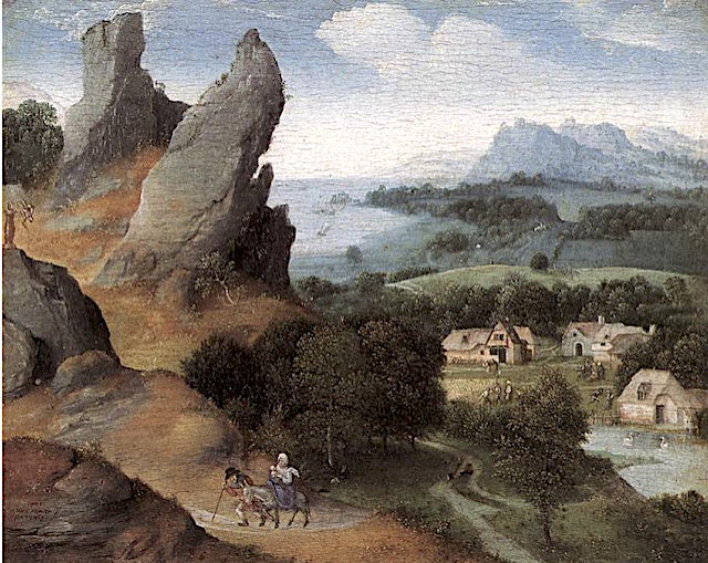
SINAÏ / JABAL MUSA   PEINT PAR  JOACHIM PATINIER

JOACHIM PATINIER (1484-1524)  Mount Sinaï ou Jabal Musa (2,285 m - 7,496ft)  Egypte   In Paysage de  la Fuite en Egypte, huile sur panneau, 1517, Royal Museum of Fine Arts, Antwerp
 
JOACHIM PATINIER (1484-1524) 
Mount Sinaï ou Jabal Musa (2,285 m - 7,496ft) 
Egypte
 
In Paysage de  la Fuite en Egypte, huile sur panneau, 1517, Royal Museum of Fine Arts, Antwerp 
 

A propos de la composition
Il s'agit évidement ici d'un Mont Sinaï imaginaire que l'on aperçoit à droite dans le loitain reproduit sur la foi de pèlerins de l'époque. Au cas où l'on aurait un doute, le petit village d'architecture flamande rassurerait tout de suite quant à la position géographique ! Ceci dit, hormis le ruisseau qui traverse ce désert du Sinaï plutôt hospitalier, la peinture des reliefs n'est pas si éloignée que cela de la réalité topographique. 
 
 Le peintre
Joachim Patinier, Patenier, ou Patinir, est un peintre et dessinateur flamand de la Haute Renaissance.  Il intégra en 1515 la Guilde de Saint-Luc des peintres d'Anvers comme franc-maître et travailla en collaboration avec différents peintres dont Quentin Metsys. Ce dernier devait être assez intime avec lui puisqu'à sa mort, il fut désigné comme l'un des tuteurs de ses enfants. Lors de son voyage aux Pays-Bas, Albrecht Dürer se lia d'amitié avec Joachim Patinier et réalisa son portrait. C'est « un bon peintre de paysage » nota-t-il dans son journal de voyage. Il lui emprunta des couleurs, un de ses élèves, et assista à son second mariage le 5 mai 1521.
Considéré comme l'un des initiateurs du genre « paysage » dans la peinture occidentale, Joachim Patinier est un peintre d'histoire. Il réalisa des peintures à l'huile sur panneaux de bois dans le genre pictural majeur qui s’inspire surtout de scènes issues de l’histoire chrétienne popularisée par La Légende dorée de Jacques de Voragine. Son style est caractérisé par l'utilisation fréquente de la perspective atmosphérique qui offre une vision panoramique en plongée. Ses compositions comportent généralement trois plans principaux distincts : un premier plan brun sur lequel sont disposés les figures principales et leurs accessoires ainsi que des éléments minéraux et végétaux (des rochers, des herbes, des fleurs, un arbre ou un arbuste presque mort), un plan moyen à dominante verte où sont représentés avec finesse et précision de nombreux personnages vaquant aux occupations les plus diverses, et un arrière-plan aux reliefs remarquables d'un bleu intense — on parle parfois de « bleu Patinir » —, qui rejoignent un ciel nuageux de même tonalité dans lequel semble surgir un orage menaçant.
Joachim Patinier semble avoir eu recours à divers collaborateurs pour exécuter les figures de premier plan de bon nombre de ses tableaux. La manière de Joachim Patinier fut reprise par bon nombre de peintres de la même génération ou de la suivante, parmi lesquels on peut citer Joos van Cleve, Corneille Metsys, Lucas Gassel, Henri Bles et le Maître des demi-figures féminines. Les emprunts thématiques et stylistiques furent parfois si importants que de nombreuses œuvres de ces continuateurs furent confondues avec celles de Joachim Patinier lui-même.
 
La montagne
Le mont Sinaï ou djebel Moussa (« montagne de Moïse ») est une montagne d'Égypte située dans le sud du Sinaï et culminant à 2 285 mètres d'altitude.
Le mont est surtout célèbre dans le récit biblique pour avoir été le lieu où Moïse rencontra Dieu pour la première fois au buisson ardent (Ex 3,1-4,17) et où il reçut les Dix Commandements (ou Dix Paroles, en Ex 20,1-17) et de nombreuses autres lois pour le peuple hébreu (Exode 19,1-31,18). Plusieurs autres localisations de cet épisode ont été proposées (voir Har Karkom et Sinaï (Bible)).
Le mont Sinaï est situé au Nord-Est de l'Égypte, dans le gouvernorat du Sinaï Sud, au niveau de la pointe sud de la presqu’île du Sinaï, à 50 kilomètres des côtes de la Mer Rouge et d'El-Tor, au sud-ouest, ainsi qu'à 75 kilomètres de Charm el-Cheikh, au sud-sud-est, et 160 kilomètres environ à vol d'oiseau du Caire. Le sommet s'élève à 2 285 mètres d'altitude, à quatre kilomètres au nord-nord-est du mont Sainte-Catherine (2 642 m), point culminant du massif et du pays. Les roches du mont Sinaï sont issues de la phase tardive du bouclier arabo-nubien. Elles sont constituées de granite avec des intrusions de roches volcaniques incluant du porphyre. La montagne s'est soulevée de 140 à 65 millions d’années BP, au cours du Crétacé.Deux chemins principaux mènent au sommet. Le plus long et le moins escarpé s’appelle Siket El Bashait ; il faut environ deux heures et demie à pied pour la gravir mais il est accessible aux chameaux. L’autre itinéraire, appelé Siket Sayidna Musa, passe dans le ravin derrière le monastère et est surnommé la route aux 3 750 « pas de la pénitence ».
Dans un registre spirituel, la montagne est à plusieurs reprises citée par les théologiens sous l’appellation « Sinaï mystique », comme étant un rite d’initiation, consacrant une spiritualité ascendante devant mener à la découverte d’un « moi supérieur » situé en son sommet qui devient alors la symbolique du but à atteindre demeurant au cœur de nombreuses pratiques initiatiques d’inspiration chrétienne, chiite et soufie. 
 
 ______________________________________

2023 - Gravir les montagnes en peinture
Un blog de Francis Rousseau   

Monday, March 27, 2023

JABAL UMM QARNAYN PEINT PAR FRANZ-WILHEM JUNGHUHN


FRANZ-WILHEM JUNGHUHN (1809-1864) Jabal Umm Qarnayn (307m) Yemen
 
FRANZ-WILHEM JUNGHUHN (1809-1864)
Jabal Umm Qarnayn (307m)
Yemen

L'artiste
Friedrich Franz Wilhelm Junghuhn est un botaniste néerlandais. Il fait ses études à Halle et à Berlin. Il officie comme chirurgien dans l’armée prussienne puis comme médecin dans l’armée française en Algérie. Il s’installe à Java et y demeure le reste de sa vie à l’exception d’un passage en Hollande de 1849 à 1855. Il fait paraître Topographische und naturwissenschaftliche Reisen durch Java [1845], Java, seine Gestalt, Pflanzendecke, und sein innerer Bau (quatre volumes, 1850-1854), Die Bättalander auf Sumatra (1847). Il étudie la géologie, la géographie et la botanique de Java.Jabal

La montagne
Jabal Umm Qarnayn (307m) est une montagne au Yémen. Elle est située dans le district d'Al Milah et la province de Muḩāfaz̧at Laḩij, dans la partie sud-ouest du pays, à 260 km au sud de Sanaa, la capitale du pays. 307 mètres au-dessus du niveau de la mer est l'emplacement de Jabal Umm Qarnayn,  ou 51 mètres au-dessus du terrain environnant . Le terrain autour de Jabal Umm Qarnayn est principalement plat, mais au nord, il est vallonné. Le point culminant de la région est Jabal al Khulū, à 650 mètres au-dessus du niveau de la mer, à 7,6 km au nord de Jabal Umm Qarnayn. Il n'y a pas de ville aux alentours de Jabal Umm Qarnayn. Le climat est chaud.[ La température moyenne est de 32 °C. Le mois le plus chaud est juin, à 37 °C, et le plus froid est janvier, avec 26 °C. La pluviométrie moyenne est de 96 millimètres par an. Le mois le plus humide est septembre, avec 17 millimètres de pluie, et le plus sec est décembre, avec 1 millimètre.
 __________________________________________


2023 - Wandering Vertexes ....
Errant au-dessus des Sommets Silencieux...
Un blog de Francis Rousseau 


Thursday, February 16, 2023

MONT BABOR / ADRAR N BABUR PEINT PAR LÉON CARRÉ


LÉON CARRÉ (1878-1942) Mont Babor / Adrar n Babur ( 2,004 m) Algérie (Petite Kabylie)  In "En Kabylie ", huile sur toile, collection privée


LÉON CARRÉ (1878-1942)
Mont Babor / Adrar n Babur ( 2,004 m)
Algérie (Petite Kabylie)

In "En Kabylie ", huile sur toile, collection privée

La montagne
Le mont Babor (2004 m), djebel Babor ou adrar n Babor parfois Grand Babor, est une montagne de la chaîne des Babors culminant en Petite Kabylie (Algérie), à l'extrémité nord de la wilaya de Sétif. La montagne abrite des forêts de Cèdre de l'Atlas et du Sapin de Numidie (espèce endémique du Babor et du Tababort). C'est sur cette montagne que fut découverte la Sittelle kabyle (oiseau endémique de la région) le 5 octobre 1975 par le belge Jean-Paul Ledant.  Le climat de la région est froid et humide avec de fortes chutes de neige en automne et en hiver et des précipitations dépassant les 1 700 mm/an. En hiver, les températures sont basses et très souvent négatives mais chaudes en été, atteignant parfois les 30 degrés.


Le peintre
Léon-Georges-Jean-Baptiste Carré entre à l'école des beaux-arts de Rennes, puis il intègre l'École des beaux-arts de Paris le 11 mars 1896 grâce à Léon Bonnat dont il suit les cours, ainsi que ceux de Luc-Olivier Merson. Il fut le double lauréat du prix Chenavard. Il expose au Salon des artistes français en 1900 puis, dès 1905, au Salon des indépendants, et effectue un premier voyage en Algérie en 1907. Il expose au Salon de la Société nationale des beaux-arts à partir de 1911, ainsi qu'au Salon d'automne. Lauréat de la bourse de la Villa Abd-el-Tif en 1909, il se fixe à Alger. Peintre orientaliste, il pratique l'huile, la gouache et le pastel. En 1927, Léon Carré contribue à la décoration du paquebot Île-de-France pour la Compagnie transatlantique, et dessine de nombreuses affiches pour la Compagnie PLM (dont celle du centenaire de l'Algérie en 1930). Il a également dessiné le billet de 50 francs de la Banque de l'Algérie émis en 1942. En 1935, il publie des compositions pour le conte de Paul Wenz, L'homme qui resta debout, dans le numéro spécial de Noël de L'Illustration.

_________________________________________

2023 - Wandering Vertexes ....
Errant au-dessus des Sommets Silencieux...
Un blog de Francis Rousseau


Wednesday, February 1, 2023

LE MONT TAMGOUT PHOTOGRAPHIÉ EN AUTOCHROME LUMIÈRE


AUTOCHROME LUMIERE Mont Tamgout (1, 252m) Algérie  In Tamgout, Atlas Tellien, Algérie, Autochrome Lumière, anonyme circa 1922


AUTOCHROME LUMIÈRE
Mont Tamgout (1, 252m)
Algérie

In Tamgout, Atlas Tellien, Algérie, Autochrome Lumière, anonyme circa 1922

La montagne
Mont Tamgout (1, 252m) est une montagne de l'Atlas tellien culminant à 1 252 m d'altitude sur le territoire de la commune d'Akerrou dans la wilaya de Tizi-Ouzou, région de Kabylie, en Algérie. Le village le plus proche de cette montagne est, le chef-lieu de la commune d'Akerrou, Tifrit n'Aït el Hadj. Le mont Tamgout est entouré du massif du même nom dont la superficie dépasse les 3 800 hectares. C'est le point culminant du territoire des Ait Flik et de toute la Kabylie maritime.

Le procédé photographique
L'Autochrome Lumière est un des premiers procédés de photographie couleur. Breveté en 1903 par les frères Lumière en France et commercialisé pour la première fois en 1907, c'était le principal procédé de photographie couleur utilisé avant l'avènement du film couleur négatif au milieu des années 1930.
Entre 1909 et 1931, une collection de 72 000 photographies autochromes, documentant la vie à l'époque dans 50 pays à travers le monde, a été créée par le banquier français Albert Kahn. La collection, l'une des plus importantes du genre au monde, est conservée au musée Albert Kahn à la périphérie de Paris. Une nouvelle compilation d'images de la collection Albert Kahn a été publiée en 2008. Plusieurs images de la collection Albert Kahn ont déjà été publiées dans ce blog.
La National Geographic Society a largement utilisé les autochromes et autres plaques d'écran couleur en mosaïque pendant plus de vingt ans. 15 000 plaques autochromes originales sont encore conservées dans les archives de la Société.
Dans l'immense collection d'œuvres du photographe pictorialiste américain Arnold Genthe de la Bibliothèque du Congrès des États-Unis, 384 de ses plaques autochromes figuraient parmi les collections en 1955.
De nombreux photographes l'ont également utilisé, comme ici, de manière anonyme. 

_________________________________________

2023 - Wandering Vertexes ....
            Errant au-dessus des Sommets Silencieux...
            Un blog de Francis Rousseau

Saturday, December 24, 2022

LE MONT SINAÏ PEINT PAR PIETER BRUEGEL L'ANCIEN 


PIETER BRUEGEL L'ANCIEN (1525-1569) Mount Sinaï / Jabal Musa (2,285 m - 7,496ft) Egypt  In "Paysage avec La Fuite en Egypte", huile sur panneau , 1563, 37.1 × 55.6 cm, Courtauld Institute of Art, London

PIETER BRUEGEL L'ANCIEN (1525-1569)
Mount Sinaï / Jabal Musa (2,285 m - 7,496ft)
Egypte

In "Paysage avec La Fuite en Egypte", huile sur panneau , 1563, 37.1 × 55.6 cm, Courtauld Institute of Art, London 

A propos de ce tableau
Il s 'agit bien entendu d'une représentation imaginaire du Mont Sinai, Breughel comme tous les autres peintres de son temps s'inspirant des récits de voyageurs ou de témoignages de pèlerins pour en dresser la silhouette. D'où certaines erreurs. Ici la plus flagrante est la présence de l'eau. De beaucoup d'eau ! Beaucoup trop  d'eau lorsqu'on sait que c'est plutôt un désert aride qui entoure le Mont Sinaï. Mais la montagne elle-même (à gauche de la composition) est décrite avec un certain réalisme, ses  célèbres trois sommets y sont et la physionomie générale n'est pas très éloignée de ce que l'on peut observer dans la réalité.

La montagne
Le mont Sinaï (2 285 m - 7 496 ft) ou Jabal Mūsā ou Gabal Mūsā (en arabe : "Montagne de Moïse" ou "Mont Moïse"), également connu sous le nom de Mont Horeb ou Jebel Musa (une montagne du même nom au Maroc), est une montagne dans la péninsule du Sinaï en Égypte. Elle est considérée comme l'emplacement le plus probable du mont Sinaï ,la montagne sacrée décrite dans la Bible.  Ce dernier est mentionné à plusieurs reprises dans le Livre de l'Exode (et d'autres livres de la Bible) ainsi que dans  le Coran. Selon la tradition juive, chrétienne et islamique, le mont Sinaï est le lieu où Moïse a reçu les Dix Commandements, les Tables de la Loi.
Le mont Sinaï est une montagne modérément élevée près de la ville de Saint Katherine dans la région du Sinaï. Il est situé juste à côté du mont Katherine (2 629 m - 8 625 pieds), le plus haut sommet d'Égypte.
Les roches du mont Sinaï se sont formées à la fin de l'évolution du bouclier arabo-nubien (ANS). Le mont Sinaï présente un complexe annulaire composé de granites alcalins pénétrés dans divers types de roches, y compris des roches volcaniques. Les granites varient en composition du syénogranite au granit de feldspath alcalin. Les roches volcaniques sont alcalines à hyperalcalines et elles sont représentées par des coulées et des éruptions subaériennes et du porphyre subvolcanique. En général, la nature des roches exposées du mont Sinaï indique qu'elles proviennent de profondeurs différentes.
Il y a deux routes principales vers le sommet. La route la plus longue et la moins profonde, Siket El Bashait, prend environ 2, heures et demi à pied, bien que des chameaux puissent être utilisés. La route la plus raide et la plus directe (Siket Sayidna Musa) monte les 3 750 "marches de pénitence" dans le ravin derrière le monastère.
Le sommet de la montagne comporte  une mosquée qui est encore utilisée par les musulmans. Il possède également une chapelle orthodoxe grecque, construite en 1934 sur les ruines d'une église du 16e siècle, qui n'est pas ouverte au public. La chapelle renferme le rocher qui est considéré comme l'endroit où furent remise à Moïse, les Tables de la Loi. Au sommet se trouve également la "Grotte de Moïse", où Moïse aurait attendu avant de  recevoir les Dix Commandements.

Le peintre
Pieter Brueghel ou Bruegel dit l'Ancien, parfois francisé en Pierre Brueghel l'Ancien (est un peintre et graveur brabançon né vers 1525 et mort le 9 septembre 1569 à Bruxelles dans les Pays-Bas espagnols.
Avec Jan van Eyck, Jérôme Bosch et Pierre Paul Rubens, il est considéré comme l'une des grandes figures de l'École flamande, et l'une des principales de l'École d'Anvers. oujours selon van Mander, il fut l'élève de Pieter Coecke van Aelst, artiste cultivé, doyen de la guilde des artistes, à la fois peintre et architecte. En 1552, il fait un voyage en Italie, résidant à Rome où il a pu travailler avec le miniaturiste Giulio Clovio. Le Port de Naples, le décor de La Chute d'Icare et du Suicide de Saül ainsi que quelques dessins témoignent de son périple. Il est vraisemblable que Brueghel ait prolongé son voyage plus au Sud. À l'arrière plan du Combat naval dans le détroit de Messine, certains ont reconnu le village de Reggio di Calabria, face à la Sicile.
Entre 1555 et 1563, il est établi à Anvers et travaille pour l'éditeur Jérôme Cock, réalisant des dessins préliminaires pour des séries d'estampes.
À Anvers, il fréquente un cercle d'artistes et d'érudits humanistes, notamment le mécène Niclaes Jonghelinck qui possédait seize de ses œuvres. Il fut aussi l'ami du cartographe Abraham Orteliusqui écrivit quelques lignes émouvantes à sa mémoire14. Mais sa vie sociale déborde largement de ce milieu intellectuel. Il fréquente volontiers les noces paysannes auxquelles il se fait inviter comme « parent ou compatriote » des époux.
En 1562, à la demande de sa future belle-mère , il s'installe à Bruxelles dans le quartier des Marolles au 132, rue Haute, dans une maison à pignons à gradins de style médiéval flamand typique du 16e siècle. C'est à l'église Notre-Dame de la Chapelle qu'il épouse en 1563 Mayken Coecke, fille de son maître Pieter Coecke van Aelst et de Mayken Verhulst. Une étude de l'archiviste Jean Bastiaensen montre que le peintre résidait 16 rue des Bogards en face du couvent éponyme. À l'époque de la Réforme, les Calvinistes se réunirent en 1579 en la maison appelée "Schavershuyse", située en face de l'église des Bogards. Trois maisons classées de la rue de la Gouttière donnent une idée du bâti de l’époque. Un vestige de la chapelle construite en 1718 se trouve inséré dans les bâtiments de l'Académie royale des beaux-arts de Bruxelles. La rue des Bogards relevait de la paroisse de l'église Notre-Dame de la Chapelle.
En 1564 naît le premier de ses fils, Pieter Brueghel le Jeune, dit Bruegel d'Enfer. La situation politique et religieuse en Flandres se dégrade. En 1567 le duc d'Albe entreprend une campagne de répression sanglante contre les rebelles, et c'est l'année même de l'exécution des comtes d'Egmont et de Horn que naît en 1568 son second fils, Jan Brueghel l'Ancien, dit Brueghel de Velours. Il semble certain que Pieter Brueghel l'Ancien ait reçu la protection du gouverneur des Pays-Bas espagnols, Antoine Perrenot de Granvelle, collectionneur de ses œuvres.

 _________________________________________

2022 - Wandering Vertexes ....
            Errant au-dessus des Sommets Silencieux...
            Un blog de Francis Rousseau

Friday, December 16, 2022

TAZOUDA ET LE HAUT ATLAS PEINT PAR JACQUES MAJORELLE


JACQUES MAJORELLE (1886-1962) Tazouda / Tondoute (1,539m - 5,049 ft) Morocco  In La Kasba de Tazouda, 1949, gouache on paper, 60 x 90cm, Musée de Tazouda


JACQUES MAJORELLE (1886-1962)
Tazouda / Tondoute (1,539m - 5,049 ft)
Maroc

In La Kasba de Tazouda, 1949, gouache sur papier, 60 x 90cm, Musée de Tazouda


La montagne
Le Haut Atlas oriental est formé des vastes plateaux d'altitude de la haute Moulouya. Ces plateaux s'étendent de Midelt — province de Khénifra, abritant le djebel Ayachi - à Imilchil - province d'Errachidia, où se trouvent le Djebel Saghro et le massif ancien de Tamlelt dont la bordure nord est occupée par ses plus hauts sommets, tel le djebel Ayachi
L'altitude s'affaiblit vers l'est, où débute le domaine des hamadas (zone pré-saharienne). Ce massif est devenu un site paléontologique de renommée internationale, à la suite de la découverte des ossements d'un dinosaure alors inconnu, l'Atlasaurus, dinosaure quadrupède herbivore d'environ 18 à 20 mètres de long qui peuplait le Maroc il y a 165 millions d'années (Jurassique moyen). Un autre dinosaure d'environ neuf mètres de long a été baptisé Tazoudasaurus naimi, du nom du village de Tazouda où il a été découvert (à 70 kilomètres de la ville de Ouarzazate). Il est plus ancien que le précédent (environ 180 millions d'années) et pourrait bien être l'« ancêtre » des sauropodes d'Amérique du Nord qui, eux, ont 140 millions d'années — une époque où l’Afrique du Nord et le continent américain étaient soudés.

Le peintre
Jacques Majorelle, fils du célèbre créateur de meubles Art nouveau Louis Majorelle, était un peintre français. Il étudie à l'École des Beaux-Arts de Nancy en 1901 puis à l'Académie Julian à Paris avec Schommer et Royer. Majorelle est devenu un peintre orientaliste réputé, mais il est surtout connu pour avoir construit la villa et les jardins qui portent désormais son nom, Les Jardins Majorelle à Marrakech.
Vers 1917, il se rendit au Maroc pour se remettre de problèmes cardiaques et après une courte période passée à Casablanca, il se rendit à Marrakech, où il tomba amoureux des couleurs vibrantes et de la qualité de la lumière qu'il y trouva. Il commença par utiliser Marrakech comme base de départ pour des voyages en Espagne, en Italie et dans d'autres parties de l'Afrique du Nord, y compris l'Égypte, avant de finalement, s'y s'installer définitivement.
Il s'est inspiré pour ses peintures de ses voyages et de Marrakech même. Ses peintures rendent compte de nombreuses scènes de rue, souks et kasbahs ainsi que de portraits d'habitants locaux. Il ouvrit un atelier d'artisanat à Marrakech et  également conçut des affiches pour promouvoir les voyages au Maroc. Il introduisit une vision plus colorée, baignée de lumière où le dessin disparaît et l'image émerge de larges taches de couleur posées à plat. C'était comme s'il avait découvert le soleil dans ces contrées. Son style fait preuve de plus de liberté et de spontanéité.
Du vivant même de Majorelle,  nombre de ses peintures  ont été vendues à des collectionneurs  privés et restent encore aujourd'hui jalousement dans ces collections. Certaines de ses premières œuvres se trouvent dans les musées autour de sa ville natale comme le Musée de l'Ecole de Nancy. Des exemples de ses travaux ultérieurs peuvent être vus à l'Hôtel Mamounia de Marrakech, au consulat de France de Marrakech, à la Villa des jardins Majorelle ou au Musée de Tazouda. 

 _________________________________________

2022 - Wandering Vertexes ....
            Errant au-dessus des Sommets Silencieux...
            Un blog de Francis Rousseau


Tuesday, August 16, 2022

RAS DASHAN SKETCHED BY HENRY SALT


HENRY SALT (1780-1827) Ras Dashen (4,550 m - 14,930 ft) Ethiopia

HENRY SALT (1780-1827)
Ras Dashen (4,550 m - 14,930 ft)
Ethiopia

In Mucculla in Abyssinia (Ethiopia), Handcolored aquatints 1809.
King Geroge III topographical collection

The mountain
Ras Dashan (4,550 m - 14,930 ft) also known as Ras Dashen or Ras Dejen, is the highest mountain in Ethiopia and fourteenth highest peak in Africa. Located in the Simien Mountains National Park in the Amhara Region North Gondar, The English form, "Ras Dashen" is a corruption of its Amharic name, "Ras Dejen", the term used by the Ethiopian Mapping Authority (EMA) which alludes to the traditional head or general who fights in front of the Emperor.
According to Erik Nilsson, Ras Dashan is the eastern peak of the rim of "an enormous volcano, the northern half of which is cut down about [a] thousand metres by numerous ravines, draining into the Takkazzi River." Its western counterpart is Mount Biuat (4,437 meters), separated by the valley of the Meshaha river. The mountain often sees violent snowfalls during the night, but given that day and night temperatures vary greatly, the snow is almost completely melted in a few hours (during the hottest period of the year), for the temperature may be over 5 degrees Celsius by midday. In winter snow falls rarely, since the majority of Ethiopia's yearly rainfall is in the summer, but if it does it usually lasts for weeks or months. The first recorded ascent by a European was in 1841, by French officers Ferret and Galinier. There is no verifiable evidence of earlier ascents by locals, but the summit climate and conditions are relatively hospitable, and there are nearby high altitude pastoral settlements. A small fort is still partially standing at around 4,300 metre SRTM data.

The artist
Henry Salt was an English artist, traveller, collector of antiquities, diplomat, and Egyptologist.
After a time as a portrait painter, Salt was permitted to travel with the English nobleman George Annesley, Viscount Valentia as his secretary and draughtsman after being recommended by Thomas Simon Butt. They started on an eastern tour in June 1802, traveling on the British East India Company's extra (chartered) ship Minerva to India via the Cape Colony. In 1805, Valentia sent Salt on a journey into the Abyssinian area (now Ethiopia) to meet with the ras of Tigré to open up trade relations on behalf of the English. While visiting there, Salt gained the respect of the ras. He returned to England on 26 October 1806. His journey home took him through Egypt where he met the pasha Mehmet Ali. Salt's paintings from the trip were used in Valentia's Voyages and Travels to India, published in 1809. The originals of all the drawings were kept by Valentia, as also the copper plates after Salt's death. The format and style of the plates is similar to Thomas and William Daniell's work, "Oriental Scenery" (1795-1808).
Salt returned to Ethiopia in 1809 on a government mission to explore trade and diplomatic links with the Tigrayan warlord Ras Wolde Selassie. Upon arrival, he was unable to meet with the king due to unrest in the country, so instead he went to stay with his friend the ras of Tigré. During this venture, Salt took on the side mission of verifying and correcting the information about the region reported by the Scottish traveler, James Bruce many years earlier. Salt came back to England in 1811 with numerous specimens of both plants and animals.

___________________________________________
2022 - Wandering Vertexes...
by Francis Rousseau

Sunday, July 17, 2022

MOUNT SINAÏ / JABAL MUSA PAINTED BY EDWARD LEAR

EDWARD LEAR(1812-1888) Mount Sinaï / Jabal Musa (2,285 m - 7,496ft) Egypt   In View of Mount Sinai, Watercolor,with some white tempera, over pencil, on cream-colored wove paper. (178 x 376 mm) Purchased as the gift of Mrs. Vincent Astor,  The Morgan Library & Museum

EDWARD LEAR (1812-1888)
Mount Sinaï / Jabal Musa (2,285 m - 7,496ft)
Egypt

In View of Mount Sinai, Watercolor,with some white tempera, over pencil, on cream-colored wove paper.
(178 x 376 mm) Purchased as the gift of Mrs. Vincent Astor,  The Morgan Library & Museum

The mountain
Mount Sinaï (2,285 m - 7,496ft) or Jabal Mūsā or Gabal Mūsā (in arab : "Moses' Mountain" or "Mount Moses"), also known as Mount Horeb or Jebel Musa (a similarly named mountain in Morocco), is a mountain in the Sinai Peninsula of Egypt that is a possible location of the biblical Mount Sinaï.
The latter is mentioned many times in the Book of Exodus (and other books of the Bible) and in the Quran. According to Jewish, Christian, and Islamic tradition, the biblical Mount Sinai was the place where Moses received the Ten Commandments (depicted in the Jean-Léon Gérôme painting above).
Mount Sinai is a moderately high mountain near the city of Saint Katherine in the Sinai region. It is next to Mount Katherine (2,629m - 8,625 ft), the highest peak in Egypt.
Mount Sinai's rocks were formed in the late stage of the Arabian-Nubian Shield's (ANS) evolution. Mount Sinai displays a ring complex that consists of alkaline granites intruded into diverse rock types, including volcanics. The granites range in composition from syenogranite to alkali feldspar granite. The volcanic rocks are alkaline to peralkaline and they are represented by subaerial flows and eruptions and subvolcanic porphyry. Generally, the nature of the exposed rocks in Mount Sinai indicates that they originated from differing depths.
There are two principal routes to the summit. The longer and shallower route, Siket El Bashait, takes about 2.5 hours on foot, though camels can be used. The steeper, more direct route (Siket Sayidna Musa) is up the 3,750 "steps of penitence" in the ravine behind the monastery.
The summit of the mountain has a mosque that is still used by Muslims. It also has a Greek Orthodox chapel, constructed in 1934 on the ruins of a 16th-century church, that is not open to the public. The chapel encloses the rock which is considered to be the source for the biblical Tablets of Stone. At the summit also is "Moses' cave", where Moses was said to have waited to receive the Ten Commandments

The painter
Edward Lear was an English artist, illustrator, musician, author and poet, and is known now mostly for his literary nonsense in poetry and prose and especially his limericks, a form he popularised. His principal areas of work as an artist were threefold: as a draughtsman employed to illustrate birds and animals; making coloured drawings during his journeys, which he reworked later, sometimes as plates for his travel books; as a (minor) illustrator of Alfred Tennyson's poems. As an author, he is known principally for his popular nonsense collections of poems, songs, short stories, botanical drawings, recipes, and alphabets. He also composed and published twelve musical settings of Tennyson's poetry.
Lear was already drawing "for bread and cheese" by the time he was aged 16.
In 1842, Lear began a journey into the Italian peninsula, travelling through the Lazio, Rome, Abruzzo, Molise, Apulia, Calabria, and Sicily. In personal notes, together with drawings, Lear gathered his impressions on the Italian way of life, folk traditions, and the beauty of the ancient monuments. Of particular interest in Lear was the Abruzzo, which he visited in 1843, through the Marsica (Celano, Avezzano, Alba Fucens, Trasacco) and the plateau of Cinque Miglia (Castel di Sangro and Alfedena), by an old sheep track of the shepherds.
Among his travels, he visited Greece and Egypt during 1848-49, and toured India and Ceylon during 1873–75. While travelling he produced large quantities of coloured wash drawings in a distinctive style, which he converted later in his studio into oil and watercolour paintings, as well as prints for his books. His landscape style often shows views with strong sunlight, with intense contrasts of colour. Between 1878 and 1883 Lear spent his summers on Monte Generoso, a mountain on the border between the Swiss canton of Ticino and the Italian region of Lombardy. His watercolor Mount Olympus dated 1849 in in the MET in New York City. His oil painting The Plains of Lombardy from Monte Generoso is in the Ashmolean Museum Oxford (UK).

_______________________________

2022 - Wandering Vertexes...
by Francis Rousseau 

Monday, July 11, 2022

DJEBEL TOUKBAL (4) PAINTED BY SIR WINSTON CHURCHILL


SIR WINSTON CHURCHILL (1874-1965) Jebel Toubkal (4,167 m - 13, 671 ft) Morocco  In Atlas mountains viewed from Marrakech, oil on canvas, 1949.

SIR WINSTON CHURCHILL (1874-1965)
Jebel Toubkal (4,167 m - 13, 671 ft)
Morocco

In Atlas mountains viewed from Marrakech, oil on canvas, 1949.


The mountain 

Jebel Toubkal (4,167 m - 13, 671 ft)  is the high point of the High Atlas as well as Morocco and North Africa . It is located 63 km south of Marrakech, in the province of Al Haouz, inside the national park that bears its name.
The word Toubkal would be a deformation of French origin of the same Amazigh name Tugg Akal or toug-akal  which means "the one who looks up the earth". The people of this region still use this name.  The Toubkal massif is made up of rocks of various natures. Dark rocks of volcanic origin are found on the summits of andesite and rhyolite. Glaciers have left characteristic marks of their passage in the form of valleys in trough. During the Würm glaciation, the present valley of Assif n'Ait Mizane  was occupied by the longest glacier in the Atlas, about 5 km long.
The climate at Jebel Toubkal  is mountainous. The snow falls in winter and covers the summit.
In the nineteenth century, the interior of Morocco was still terra incognita for the Europeans and for a long time the Jebel Ayachi (3,747 m -12,293ft) ) passed for the highest summit of the High Atlas. In fact, the Toubkal was officially climbed for the first time only on 12 June 1923 by the Marquis de Segonzac, accompanied by Vincent Berger and Hubert Dolbeau. The cairns which they found on the summit had been built by the Berbers of the environs for whom the Toubkal is a holy place dedicated to Sidi Chamarouch (or Chamharouch). A sanctuary is dedicated to him on the way from Imlil to Toubkal.
The ascent of the roof of North Africa attracts a large number of followers of the trekking. This ascent attracts the crowd as much as it does not present great technical difficulties and that the assistance of the muleteers and their mules reduces the physical efforts. The altitude is relatively high (3,200 meters at the shelter and 4,167 meters at the summit).

The artist
Winston Leonard Spencer-Churchill was forty before he discovered the pleasures of painting. The compositional challenge of depicting a landscape gave the heroic rebel in him temporary repose. He possessed the heightened perception of the genuine artist to whom no scene is commonplace. Over a period of forty-eight years his creativity yielded more than 500 pictures. His art quickly became half passion, half philosophy. He enjoyed holding forth in speech and print on the aesthetic rewards for amateur devotees. To him it was the greatest of hobbies. He had found his other world -- a respite from crowding events and pulsating politics.
Encouragement to persevere with his hobby stemmed from an amateur prize (his first) which he won for "Winter Sunshine, Chartwell" a bright reflection of his Kentish home. He sent five paintings to be exhibited in Paris in the 1920s.
Modesty shone through that self-estimate. Modesty - and warm sympathy --were undeniably evident in what Churchill told a fellow painter, Sergeant Edmund Murray, his bodyguard from 1950 to 1965. Murray had been in the Foreign Legion and the London Metropolitan Police. Interviewing him to gauge his suitability, Churchill said: "You have had a most interesting life. And I hear you even paint in oils." After Murray had his work rejected by the Royal Academy, Churchill told him: "You know, your paintings are so much better than mine, but yours are judged on their merit."
Churchill's progressive workmanship demonstrates that a pseudonym employed at a crucial stage shrewdly enabled him to find out where he stood before moving on to fine-tool his talent.Churchill again favoured a pseudonym (Mr. Winter) in 1947 when offering works to the Royal Academy, so his fame in other spheres was not exploited. Two pictures were accepted and eventually the title of Honorary Academician Extraordinary was conferred on him. He earned it. That is borne out by the conclusion of the renowned painter Sir Oswald Birley: "If Churchill had given the time to art that he has given to politics, he would have been by all odds the world's greatest painter." Connoisseurs of Sir Winston's art stoutly defend their individual preference, but there are convincing arguments for bestowing highest praise on "The Blue Sitting Room, Trent Park" which was sold in 1949 to aid charity.
Despite outward flippancy, Churchill had a true craftsman's dedication when he took up a paint brush. He consulted teachers admired for their professionalism. He was fond of citing Ruskin's Elements of Drawing and readily accepted Sir William Orpen's suggestion that he should visit Avignon, where the light can verge on a miracle. He recalled an encounter on the Côte d'Azur with artists who worshipped at the throne of Cezanne and gratefully acknowledged the inspiration he derived from their exchange. Marrakech, Morocco -- irresistible and productive -- always brought out the best in him.
Churchill sought and found tranquillity in his art. His much quoted words, summing up expectations of celestial bliss, retain their lustre: "When I get to heaven I mean to spend a considerable portion of my first million years in painting, and so get to the bottom of the subject..."
___________________________________________


2022 - Wandering Vertexes...
by Francis Rousseau
 

Thursday, June 30, 2022

PICO DEL TEIDE SKETCHED BY ALEXANDER VON HUMBOLDT


ALEXANDER VON HUMBOLDT (1769-1859), Pico del Teide (3, 718 m -12, 198 ft) Tenerife - Canari Islands - Spain   In  "Intérieur du Cratère du Pic de Teneriffe " Dessin, Alexander von Humboldt


ALEXANDER VON HUMBOLDT (1769-1859)
Pico del Teide (3, 718 m -12, 198 ft)
Tenerife - Canari Islands - Spain

 In  "Intérieur du Cratère du Pic de Teneriffe " Dessin, Alexander von Humboldt


The mountain
Pico del Teide (3,718m - 12,198 ft) (« Teide Peak") is a volcano on Tenerife in the Canary Islands, Spain. Before the 1495 Spanish colonization of Tenerife, the native Guanches called the volcano Echeyde, which in their legends referred to a powerful figure leaving the volcano, which could turn into hell. El Pico del Teide is the modern Spanish name.
Its summit is the highest point in Spain and the highest point above sea level in the islands of the Atlantic. If measured from its base on the ocean floor, it is at 7,500 m-24,600 ft the third highest volcano on a volcanic ocean island in the world after Mauna Kea and Mauna Loa in Hawaii. Its elevation makes Tenerife the tenth highest island in the world. It remains active: its most recent eruption occurred in 1909 from the El Chinyero vent on the northwestern Santiago rift.
Historical volcanic activity on the island is associated with vents on the Santiago or northwest rift (Boca Cangrejo in 1492, Montañas Negras in 1706, Narices del Teide or Chahorra in 1798 and El Chinyero in 1909) and the Cordillera Dorsal or northeast rift (Fasnia in 1704, Siete Fuentes and Arafo in 1705). The 1706 Montañas Negras eruption destroyed the town and principal port of Garachico, as well as several smaller villages.
In 1492, Christopher Columbus reported seeing "a great fire in the Orotava Valley" as he sailed past Tenerife on his voyage to discover the New World. This was interpreted as indicating that he had witnessed an eruption there. Radiometric dating of possible lavas indicates that in 1492 no eruption occurred in the Orotava Valley, but one did occur from the Boca Cangrejo vent.
The last summit eruption from Teide occurred about the year 850 CE, and this eruption produced the "Lavas Negras" that cover much of the flanks of the volcano.
About 150,000 years ago, a much larger explosive eruption occurred, probably of Volcanic Explosivity Index 5.
The United Nations Committee for Disaster Mitigation designated Teide a Decade Volcano because of its history of destructive eruptions and its proximity to several large towns, of which the closest are Garachico, Icod de los Vinos and Puerto de la Cruz. Teide, Pico Viejo and Montaсa Blanca form the Central Volcanic Complex of Tenerife.
In a publication of 1626, Sir Edmund Scory, who probably stayed on the island in the first decades of the 17th century, gives a description of Teide, in which he notes the suitable paths to the top and the effects the considerable height causes to the travellers, indicating that the volcano had been accessed via different routes before the 17th century. In 1715 the English traveler J. Edens and his party made the ascent and reported their observations in the journal of the Royal Society in London.
After the Enlightenment, most of the expeditions that went to East Africa and the Pacific had Teide as one of the most rewarding targets. The expedition of Lord George Macartney, George Staunton and John Barrow in 1792 almost ended in tragedy, as a major snowstorm and rain swept over them and they failed to reach the peak of Teide, just barely getting past Montaña Blanca.
During an expedition to Kilimanjaro, the German adventurer Hans Heinrich Joseph Meyer visited Teide in 1894 to observe ice conditions on the volcano. He described the two mountains as "two kings, one rising in the ocean and the other in the desert and steppes"
The volcano and its surroundings comprise Teide National Park, which has an area of 18,900 hectares (47,000 acres) and was named a World Heritage Site by UNESCO on June 28, 2007. Teide is the most visited natural wonder of Spain, the most visited national park in Spain and Europe and – by 2015 – the eighth most visited in the world, with some 3 million visitors yearly. A major international astronomical observatory is located on the slopes of the mountain.

The cartographer
Friedrich Wilhelm Heinrich Alexander von Humboldt was a Prussian geographer, naturalist, explorer, and influential proponent of Romantic philosophy and science. He was the younger brother of the Prussian minister, philosopher, and linguist Wilhelm von Humboldt (1767–1835). Humboldt's quantitative work on botanical geography laid the foundation for the field of biogeography. Humboldt's advocacy of long-term systematic geophysical measurement laid the foundation for modern geomagnetic and meteorological monitoring.
Between 1799 and 1804, Humboldt travelled extensively in Latin America, exploring and describing it for the first time from a modern scientific point of view. His description of the journey was written up and published in an enormous set of volumes over 21 years. Humboldt was one of the first people to propose that the lands bordering the Atlantic Ocean were once joined (South America and Africa in particular). Humboldt resurrected the use of the word cosmos from the ancient Greek and assigned it to his multi-volume treatise, Kosmos, in which he sought to unify diverse branches of scientific knowledge and culture. This important work also motivated a holistic perception of the universe as one interacting entity.
On their way back to Europe from Mexico on their way to the United States, Humboldt and his fellow scientist Aimé Bonpland stopped in Cuba for a While. After their first stay in Cuba of three months they returned the mainland at Cartagena de Indias (now in Colombia), a major center of trade in northern South America. Ascending the swollen stream of the Magdalena River to Honda and arrived in Bogotá on July 6, 1801 where they met Spanish botanist José Celestino Mutis, the head of the Royal Botanical Expedition to New Granada, staying there until September 8, 1801. Mutis was generous with his time and gave Humboldt access to the huge pictorial record he had compiled since 1783. Humboldt had hopes of connecting with the French sailing expedition of Baudin, now finally underway, so Bonpland and Humboldt hurried to Ecuador. They crossed the frozen ridges of the Cordillera Real, they reached Quito on 6 January 1802, after a tedious and difficult journey.
Their stay in Ecuador was marked by the ascent of Pichincha and their climb of Chimborazo, where Humboldt and his party reached an altitude of 19,286 feet (5,878 m). This was a world record at the time, but a thousand feet short of the summit. Humboldt's journey concluded with an expedition to the sources of the Amazon en route for Lima, Peru.
At Callao, the main port for Peru, Humboldt observed the transit of Mercury. On 9 November and studied the fertilizing properties of guano, rich in nitrogen, the subsequent introduction of which into Europe was due mainly to his writings.

___________________________________________
2022 - Wandering Vertexes...
by Francis Rousseau

Wednesday, May 25, 2022

MOUNT SINAÏ / JABAL MUSA PAINTED BY J.M.W. TURNER


J.M.W. TURNER  (1775–1851) Mount Sinaï / Jabal Musa (2,285 m - 7,496ft) Egypt   In "Mount Sinai, the valley in which the Children of Israel were encamped",

J.M.W. TURNER  (1775–1851)
Mount Sinaï / Jabal Musa (2,285 m - 7,496ft)
Egypt 

In "Mount Sinai, the valley in which the Children of Israel were encamped",
pencil, pen, ink and watercolor on paper, 12.7 x 20.2 cm.
Private collection ( Christie's London/ 06/07/2010)

About this Painting
It descibes the moment Moses have waited to receive the Ten Commandments.

The mountain
Mount Sinaï (2,285 m - 7,496 ft) or Jabal Mūsā or Gabal Mūsā (in arab : "Moses' Mountain" or "Mount Moses"), also known as Mount Horeb or Jebel Musa (a similarly named mountain in Morocco), is a mountain in the Sinai Peninsula of Egypt that is a possible location of the biblical Mount Sinai. The latter is mentioned many times in the Book of Exodus (and other books of the Bible) and the Quran. According to Jewish, Christian, and Islamic tradition, the biblical Mount Sinai was the place where Moses received the Ten Commandments.
Mount Sinai is a moderately high mountain near the city of Saint Katherine in the Sinai region.
It is next to Mount Katherine (2,629 m - 8,625 ft), the highest peak in Egypt.
Mount Sinai's rocks were formed in the late stage of the Arabian-Nubian Shield's (ANS) evolution. Mount Sinai displays a ring complex that consists of alkaline granites intruded into diverse rock types, including volcanics. The granites range in composition from syenogranite to alkali feldspar granite. The volcanic rocks are alkaline to peralkaline and they are represented by subaerial flows and eruptions and subvolcanic porphyry. Generally, the nature of the exposed rocks in Mount Sinai indicates that they originated from differing depths.
There are two principal routes to the summit. The longer and shallower route, Siket El Bashait, takes about 2.5 hours on foot, though camels can be used. The steeper, more direct route (Siket Sayidna Musa) is up the 3,750 "steps of penitence" in the ravine behind the monastery.
The summit of the mountain has a mosque that is still used by Muslims. It also has a Greek Orthodox chapel, constructed in 1934 on the ruins of a 16th-century church, that is not open to the public. The chapel encloses the rock which is considered to be the source for the biblical Tablets of Stone. At the summit also is "Moses' cave", where Moses was said to have waited to receive the Ten Commandments.

The painter
The english painter Joseph Mallord William Turner was considered a controversial figure in his day, but is now regarded as the artist who elevated landscape painting to an eminence in the history of painting. Although renowned for his oil paintings, Turner is also one of the greatest masters of British watercolour landscape painting. He is commonly known as "the painter of light" and his work is regarded as a Romantic preface to Impressionism.
In his thirties, Turner travelled widely in Europe, starting with France and Switzerland in 1802 and studying in the Louvre in Paris in the same year. He made many visits to Venice. Turner's talent was recognized early in his life. Financial independence allowed Turner to innovate freely; his mature work is characterized by a chromatic palette and broadly applied atmospheric washes of paint. According to David Piper's The Illustrated History of Art, his later pictures were called "fantastic puzzles." Turner was recognized as an artistic genius: influential English art critic John Ruskin described him as the artist who could most "stirringly and truthfully measure the moods of Nature."
Turner's major venture into printmaking was the Liber Studiorum (Book of Studies), seventy prints that he worked on from 1806 to 1819. The Liber Studiorum was an expression of his intentions for landscape art. The idea was loosely based on Claude Lorrain's Liber Veritatis (Book of Truth), where Lorrain had recorded his completed paintings; a series of print copies of these drawings, by then at Devonshire House, had been a huge publishing success. Turner's plates were meant to be widely disseminated, and categorized the genre into six types: Marine, Mountainous, Pastoral, Historical, Architectural, and Elevated or Epic Pastoral. His printmaking was a major part of his output, and a museum is devoted to it, the Turner Museum in Sarasota, Florida, founded in 1974 by Douglass Montrose-Graem to house his collection of Turner prints.
Turner placed human beings in many of his paintings to indicate his affection for humanity on the one hand (note the frequent scenes of people drinking or working or walking in the foreground), but its vulnerability and vulgarity amid the 'sublime' nature of the world on the other. 'Sublime' here means awe-inspiring, savage grandeur, a natural world unmastered by man, evidence of the power of God – a theme that romanticist artists and poets were exploring in this period. Although these late paintings appear to be 'impressionistic' and therefore a forerunner of the French school, Turner was striving for expression of spirituality in the world, rather than responding primarily to optical phenomena.
Turner used pigments like carmine in his paintings, knowing that they were not long-lasting, despite the advice of contemporary experts to use more durable pigments. As a result, many of his colours have now faded greatly.
John Ruskin says in his "Notes" on Turner in March 1878 : "His true master was Dr Monro; to the practical teaching of that first patron and the wise simplicity of method of watercolour study, in which he was disciplined by him and companioned by Girtin, the healthy and constant development of the greater power is primarily to be attributed; the greatness of the power itself, it is impossible to over-estimate. "

_______________________________
2022 - Wandering Vertexes...
by Francis Rousseau

Friday, May 13, 2022

ALEXANDRA PEAK AND MARGHERITA PEAK BY VITTORIO SELLA


VITTORIO SELLA (1859-1943) Alexandra Peak / Mount Stanley (5,091m - 16,703 ft) Congo - Uganda border    In Alexandra peak and Margherita peak from the Stanley Plateau, photo, 1906


VITTORIO SELLA (1859-1943)
Alexandra Peak / Mount Stanley (5, 091m - 16,703 ft)
Margherita Peak / mount stanley (5,109 m-16,763 ft)
Congo - Uganda border

  In Alexandra peak  and Margherita peak from the Stanley Plateau, photo, 1906


The mountain
Alexandra Peak (5,091m - 16,703ft) is part of Mount Stanley located in the Rwenzori range, the highest mountain of both Democratic Republic of the Congo and Uganda, and the third highest in Africa, after Mount Kilimanjaro (5,895 m -19,340ft) and Mount Kenya (5,199 m - 17,057ft).
Mount Stanley consists of two twin summits and several lower peaks which are :
Margherita Peak (5,109m - 16,763ft), Alexandra Peak (5,091m - 16,703ft), Albert Peak (5,087m - 16,690ft), Savoia Peak (4,977m - 16,330ft), Ellena Peak (4,968m -16,300ft), Elizabeth Peak (4,929m - 16,170 ft), Phillip Peak (4,920m - 16,140ft), Moebius Peak (4,916m - 16,130 ft) and Great Tooth (4,603m - 15,100ft).
The peak and several other surrounding peaks are high enough to support glaciers. Mount Stanley is named for the journalist and explorer, Sir Henry Morton Stanley. It is part of the Rwenzori Mountains National Park, a UNESCO world Heritage Site.
Mt. Stanley was first climbed in 1906 by the Prince Luigi Amedeo di Savoia , Duke of the Abruzzi, (1873-1933), J. Petigax, C. Ollier, and J. Brocherel. He is known as well for his Arctic explorations and for his mountaineering expeditions, particularly to Mount Saint Elias (Alaska–Yukon) and K2 (Pakistan–China). Margherita Peak is named after Queen Margherita of Italy the prince's cousin.
The Rwenzori Mountains National Park is considered a model for integration of cultural values into the Protected Area Management framework as an innovative approach to resource management, the first of its kind in Africa. As a result the local communities have embraced collaborative resource management initiatives. Given its significance as one of the biodiversity hotspots in the Albertine Rift, various local and international NGOs have supported the management and conservation of the property. A General Management Plan guides management operations on-site. Key challenges to address include illegal felling of trees, snow recession due to global warming, human population pressure adjacent to the property and management of waste generated through tourism operations. UWA is addressing the above threats through resource protection, community conservation education, research and ranger-based monitoring, ecotourism and transboundary initiatives with the DRC. The long-term maintenance of the integrity of the property will be achieved through sustainable financing, ecological monitoring, continued collaboration with key stakeholders and regional cooperation.

The artist
Vittorio Sella is a mountain italian climber and photographer who took his passion for mountains from his uncle, Quintino Sella, founder of the Italian Alpine Club. He accomplished many remarkable climbs in the Alps, the first wintering in the Matterhorn and Mount Rose (1882) and the first winter crossing of Mont Blanc (1888) and Les Rouies (1900).
He took part in various expeditions outside Italy:
- Three in the Caucasus in 1889, 1890 and 1896 where a summit still bears his name;
- The ascent of Mount Saint Elias in Alaska in 1897;
- Sikkim and Nepal in 1899;
- Possibly climb Mount Stanley in Uganda in 1906 during an expedition to the Rwenzori;
- Recognition at K2 in 1909;
- In Morocco in 1925.
During expeditions in Alaska, Uganda and Karakoram, he accompanied the Duke of Abruzzi, Prince Luigi Amedeo di Savoia.
Sella continues the practice of climbing into his old age, completing his final attempt in the Matterhorn at the age of 76; a climb he had to interrupt the rise following an accident in which one of his guides injured. He died in his hometown during World War II. His photographic collection is now managed by the Sella Foundation.
His photos mountain are still considered today to be among the finest ever made.
Jim Curran believes that "Sella remains probably the greatest photographer of the mountain. His name is synonymous with technical perfection and aesthetic refinement. "
The quality of the pictures of Vittorio Sella is partly explained by the use of a view camera 30 × 40 cm, despite the difficulty of the transportation of such a device, both heavy and fragile in places inaccessible; to be able to transport it safely, he had to make special pieces that can be stored in saddle bags. His photographs have been widely distributed, either through the press or in the galleries, and were unanimously celebrated; Ansel Adams, who was able to admire thirty-one in an exhibition that was organized at Sella American Sierra Club, said they inspired him "a religious kind of sense of wonder." Many of his pictures were taken in the mountains for the very first time in the History, which give them a much artistic, historical but also scientific value ; for example, one could measure the decline in the Rwenzori glaciers in Central Africa.
___________________________

2022 - Wandering Vertexes...
by Francis Rousseau

Tuesday, May 10, 2022

THE WATERBERG PAINTED BY JACOBUS HENDRIK PIERNEEF


JACOBUS HENDRIK PIERNEEF (1886-1957) The Waterberg (18,30 m - 6,003 ft) South Africa (Limpopo)  In Bushveld, 1942, watercolor
 
JACOBUS HENDRIK PIERNEEF (1886-1957)
The Waterberg (1, 830 m - 6, 003 ft)
South Africa (Limpopo)

In Bushveld, 1942, watercolor


The Mountains 

The Waterberg (1,830 m - 6,003 ft) (Thaba Meetse) is a mountainous massif of approximately 654,033 hectare in north Limpopo Province, South Africa. The average height of the mountain range is 600 m with a few peaks rising up to 2000 m above sea level. Vaalwater town is located just north of the mountain range. The extensive rock formation was shaped by hundreds of millions of years of riverine erosion to yield diverse bluff and butte landform. The ecosystem can be characterised as a dry deciduous forest or Bushveld. Within the Waterberg there are archaeological finds dating to the Stone Age, and nearby are early evolutionary finds related to the origin of humans. Waterberg is the first region in the northern part of South Africa to be named as a Biosphere Reserve by UNESCO.

The painter

Jacobus Hendrik (Henk) Pierneef (usually referred to as Pierneef) was a South African landscape artist, generally considered to be one of the best of the old South African masters. His distinctive style is widely recognized and his work was greatly influenced by the South African landscape.
Most of his landscapes were of the South African highveld, which provided a lifelong source of inspiration for him. Pierneef's style was to reduce and simplify the landscape to geometric structures, using flat planes, lines and colour to present the harmony and order in nature. This resulted in formalised, ordered and often-monumental view of the South African landscape, uninhabited and with dramatic light and colour.
Pierneef's work can be seen worldwide in many private, corporate and public collections, including the Africana Museum, Durban Art Gallery, Johannesburg Art Gallery, King George VI Art Gallery, Pierneef Museum and the Pretoria Art Gallery.

___________________________

2022 - Wandering Vertexes...
by Francis Rousseau


Thursday, March 3, 2022

RAS MOULAY ALI PAINTED BY JACQUES MAJORELLE

JACQUES MAJORELLE (1886-1962) Ras Moulay Ali, (603 m-1 978 fr) Morocco  In "Tassa, Haut Sexaoua, Grand Atlas, le Ras Moulay Ali", Technique mixte rehaussée d'or et d'argent,1929


JACQUES MAJORELLE (1886-1962)
Ras Moulay Ali, (603 m-1 978 fr)
Morocco

In "Tassa, Haut Sexaoua, Grand Atlas, le Ras Moulay Ali", Technique mixte rehaussée d'or et d'argent,1929


About the painting
In 1926 Majorelle undertook a journey across the Kasbahs of the Atlas. Tassa, easily recognized by its impressive terrace-like layout, was a frequent source of inspiration for Majorelle in the course of 1929. His use of an elaborate technique of tempera with gold and silver highlights adds a strong graphic dimension to the painting. Applying black and ochre highlights, Majorelle subtly hints to the warm lighting of sunset, which accentuates the volume effect, highlighting the terraces and the Great-Atlas in the background. Also, the greenery diffuses an impression of coolness which is in stark contrast with the consuming heat of the dry mineral landscape.“His new compositions exude a distinctive penchant for neatness and simplicity, immense precision and an effort in researching a voluntarily decorative layout.  His fifty compositions were drawn with implacable rigor. The coloring appears in mellow hues and muted shades, which once highlighted with gold and silver, invigorate the entire composition with rich, stirring intemporality” In November 1930, in parallel with an exhibition of seventy drawings and paintings of Kasbahs held at the Renaissance gallery, a book containing thirty views of Kasbahs was also published.
(cf, Félix Marcilhac, La vie et l'œuvre de Jacques Majorelle (1886 - 1962), ed.ACR, 1995, p.137-138)

The painter
Jacques Majorelle son of the celebrated Art Nouveau furniture designer Louis Majorelle, was a French painter. He studied at the École des Beaux-Arts in Nancy in 1901 and later at the Académie Julian in Paris with Schommer and Royer. Majorelle became a noted Orientalist painter, but is most remembered for constructing the villa and gardens that now carry his name, Les Jardins Majorelle in Marrakech.
In around 1917 he travelled to Morocco to recover from heart problems and after short period spent in Casablanca, he visited Marrakech, where he fell in love with the vibrant colours and quality of light he found there. Initially, he used Marrakech as a base for trips to Spain, Italy and other parts of North Africa, including Egypt. Eventually, however, he settled in Marrakech permanently.
He drew inspiration for his paintings from his trips and from Marrakesch itself. His paintings include many street scenes, souks and kasbahs as well as portraits of local inhabitants. He opened a handicrafts workshop in Marrakech and also designed posters to promote travel to Morocco. His work was profoundly affected by his voyages around the Mediterannean and North Africa. He introduced a more coloured vision, bathed in light where the drawing disappears and the image emerges from large spots of colour laid flat. It seemed as if he had discoved the sun in these countries. His style exhibited more freedom and spontaneity.
In 1919, he married Andrée Longueville and the pair lived in an apartment near the Jemâa el-Fna Square (then at the palace of Pasha Ben Daoud). In 1923, Jacques Majorelle bought a four acre plot, situated on the border of a palm grove in Marrakech and in 1931, he commissioned the architect, Paul Sinoir, to design a Cubist villa for him. He gradually purchased additional land, extending his holding by almost 10 acres. In the grounds around the residence, Majorelle began planting a luxuriant garden which would become known as the Jardins Majorelle or Majorelle Garden. He continued to work on the garden for almost forty years. The garden is often said to be the his finest work. Majorelle developed a special shade of the colour blue, which was inspired by the blue tiles prevalent in southern Morocco. This colour was used extensively in Majorelle's house and garden, and now carries his name; Majorelle Blue.
The garden proved costly to run and in 1947, Majorelle opened the garden to the public with an admission fee designed to defray the cost of maintenance. He sold the house and land in the 1950s, after which it fell into disrepair.
Majorelle was sent to France for medical treatment in 1962 following a car accident, and died in Paris, later that year of complications from his injuries. He is buried in Nancy, the place of his birth.
During his lifetime, many of Majorelle's paintings were sold to private buyers and remain in private collections. Some of his early works can be found in Museums around his birthplace such as the Musée de l'Ecole de Nancy. Examples of his later work can be seen in the Mamounia Hotel, Marrakesch, the French Consulate of Marrakech and in the Villa at the Majorelle Gardens.

__________________________________________
2022 - Wandering Vertexes...
by Francis Rousseau