google.com, pub-0288379932320714, DIRECT, f08c47fec0942fa0 GRAVIR LES MONTAGNES... EN PEINTURE: 0 - No elevation data
Showing posts with label 0 - No elevation data. Show all posts

Friday, April 15, 2022

NAANU-I-CAKE PAINTED BY CONSTANCE GORDON-CUMMING (1837–1924)


CONSTANCE GORDON-CUMMING (1837–1924) Naanu-i-Cake (no elevation data) Fiji

CONSTANCE GORDON-CUMMING (1837–1924)
Naanu-i-Cake (no elevation data)
Fiji

In "Nananu, Fiji ", watercolor 28.5 x 42 cm

The volcano
Naanu-i-Cake  (no elevation data) is a volcanic island in Fiji less than one kilometer off the coast of the main island of Viti Levu, near the Rakiraki-district in Ra Province. Nananu-i-Cake is located immediately next to the island of Nananu-i-Ra. Nananu-i-Cake and Mabua (the islet located immediately to the southeast) islands are about 600 acres (242.81 hectares) in area. The main residence on the island was designed by the architecture firm of Murray Cockburn, based in Auckland.  A deep-water jetty is on the island's western shore.  In 1974, Sir Harold Mitchell visited Fiji from the UK and purchased Nananu-i-Cake and Mabua as a retreat. Because of Harold's position of Vice-Chairman of the Conservative Party under Sir Winston Churchill and his social and political standing, several high-profile dignitaries visited and stayed on the island. Commemorative trees were planted for many of these high-profile visits. Nananu-i-Cake has remained in Sir Harold Mitchell's family since 1974.  Nananu-i-Cake also retains evidence of moka, stone formations built in tidal areas to trap fish at low tide, and ring-wall fortifications built with volcanic rocks. As of 2012, the entire island is tentatively available for sale as a private island, for an estimated equivalent of around $8-8.5 million USD. In early 2022 the island received renewed attention on social media as self-proclaimed crypto-enthustiasts Max Olivier and Helena López Jurado announced plans to purchase the Nananu-i-Cake and build a private resort aimed at other crypto-enthusiasts using money raised from selling NFTs tied to property on the island to prospective residents.

The painter
Constance Frederica “Eka” Gordon-Cumming was a noted Scottish travel writer and painter. Born in a wealthy family, she travelled around the world and painted described scenes and life as she saw them.
Constance Gordon-Cumming was a prolific landscape painter, mostly in Asia and the Pacific. She painted over a thousand watercolors and worked with a motto to ‘never a day without at least one careful-coloured sketch’ starting her day at 5 am while in India. Places she visited include Australia, New Zealand, America, China, and Japan.
She arrived in Hilo, Hawaii in October 1879, and was among the first artists to paint the active volcanoes. Her Hawaii travelogue, Fire Fountains: The Kingdom of Hawaii, was published in Edinburgh in 1883. She had several dangerous moments but her travel ended in 1880 when the Montana that she was on ran into rocks at Holyhead. While most of the passengers took the lifeboat, she stayed on last along with the captain to save her paintings and was rescued many hours later. She returned to live at Crieff with her widowed sister Eleanor and continued to write books.
Her best known books are At Home in Fiji and A Lady's Cruise on a French Man-of-War. The latter book resulted from an invitation to join a French ship put into service for the Bishop of Samoa so that he could visit remote parts of his far-flung diocese.
Miss Gordon-Cumming received much criticism from male writers of the era, perhaps because she did not fit in the traditional Victorian role of women, as she often traveled alone and unaided.
In any case, her landscape drawings and watercolors seem to be universally admired.

___________________________________________
2022 - Wandering Vertexes...
by Francis Rousseau

Sunday, August 22, 2021

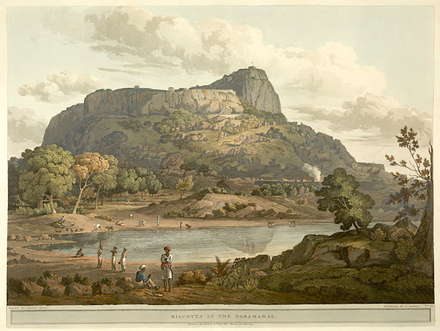
RAYAKOTTAI BY HENRY SALT


HENRY SALT (1780-1827) Rayakottai (No elevation data) India (Tamil Nadu)  In " Riacotta in the Baramahal,' aquatint, from

HENRY SALT (1780-1827)
Rayakottai (No elevation data)
India (Tamil Nadu)

In " Riacotta in the Baramahal,' aquatint, 1806, from  
Twenty Four Views in St. Helena, the Cape, India, Ceylon, the Red Sea, Abyssinia and Egypt, 
 The British Library


About the plate
This aquatint was taken from plate 12 of Henry Salt's Twenty Four Views in St. Helena, the Cape, India, Ceylon, the Red Sea, Abyssinia and Egypt. Salt visited Rayakottai in Tamil Nadu on his way to the Cauvery Falls. Viscount Valentia George Annesley wrote of its importance as a point of communication between Mysore and the Carnatic: "[Governor General] Lord Cornwallis ... had the fortifications strengthened. At present they consist of the hill, whose top is only approachable by a narrow flight of steps, and a fort at the bottom where are very comfortable houses for the officers. The scenery is wild and abrupt, consisting of rocky hills, with woods and jungle between ... the climate is so moderate, that every kind of fruit and vegetable may be reared in a degree of perfection that is unknown on the sultry plains around Madras.". For some reason, this impressed the british  by the fact it was " as high as a mountain". So.... do I year mountain ?

The place
Rayakottai, also spelled Rayakotta is not not really what we can alled a mountain, but a hill or a ridge like there are many others in this blog.  In reality it is a fort ! But it is designed quite like a mountain !!! It is located neat a town in Denkanikottai taluk, Krishnagiri District, Tamil Nadu, India. It is 73 kilometres (45 mi) from Bangalore.  The fort was built by King Krishna deverayar and situated within the town of Rayakottai which is one of the ancient fortress in the Krishnagiri district. It is now one of the protected monument by the Archaeological Survey of India. In the 18th century Hyder Ali and Tipu sultan captured this fort. The fort was captured by Major Gowdie during the third Anglo-Mysore War in 1791. According to the Treaty of Srirangapatna, this fort came into the hands of the British. 

The artist
Henry Salt was an English artist, traveller, collector of antiquities, diplomat, and Egyptologist.
After a time as a portrait painter, Salt was permitted to travel with the English nobleman George Annesley, Viscount Valentia as his secretary and draughtsman after being recommended by Thomas Simon Butt. They started on an eastern tour in June 1802, traveling on the British East India Company's extra (chartered) ship Minerva to India via the Cape Colony. In 1805, Valentia sent Salt on a journey into the Abyssinian area (now Ethiopia) to meet with the ras of Tigré to open up trade relations on behalf of the English. While visiting there, Salt gained the respect of the ras. He returned to England on 26 October 1806. His journey home took him through Egypt where he met the pasha Mehmet Ali. Salt's paintings from the trip were used in Valentia's Voyages and Travels to India, published in 1809. The originals of all the drawings were kept by Valentia, as also the copper plates after Salt's death. The format and style of the plates is similar to Thomas and William Daniell's work, "Oriental Scenery" (1795-1808).
Salt returned to Ethiopia in 1809 on a government mission to explore trade and diplomatic links with the Tigrayan warlord Ras Wolde Selassie. Upon arrival, he was unable to meet with the king due to unrest in the country, so instead he went to stay with his friend the ras of Tigré. During this venture, Salt took on the side mission of verifying and correcting the information about the region reported by the Scottish traveler, James Bruce many years earlier. Salt came back to England in 1811 with numerous specimens of both plants and animals.

___________________________________________
2021 - Wandering Vertexes...
by Francis Rousseau


Saturday, May 22, 2021

THE NGORONGORO CRATER PAINTED BY A. G. CARRICK / H.M KING CHARLES III


A. G. CARRICK / H.M KING CHARLES III former PRINCE OF WALES (bn.1948) Kilimandjaro (5,885m - 19,340ft) Tanzania    In  Ngorongoru from Hugo Hill, Serengeti plains, Tanzania, 1997, watercolor on paper

A. G. CARRICK / H.M KING CHARLES III former PRINCE OF WALES (bn.1948)
The Ngorongoro Crater ( -600m / - 1968ft)
Tanzania


 In  Ngorongoru from Hugo Hill, Serengeti plains, Tanzania, 1997, watercolor on paper, 

 
The volcano
The Ngorongoro Crater is a large circular caldera over twenty kilometers in diameter located in the heart of the Ngorongoro massif in northern Tanzania, in the eastern branch of the Great Rift Valley. This crater, now extinct, was formed following the collapse of a volcano on itself when its magma chamber emptied during a volcanic eruption. Ngorongoro is the largest intact and unsubmerged caldera in the world1 with 326 km2 in area. It is located in the Ngorongoro conservation area, a World Heritage protected area. Hotels are located on the edges of the crater and organize day and night excursions there to observe wildlife.Four hundred species of birds inhabit the crater.The forest lining the inner wall of the caldera descends sparingly to the meadows where herbivores graze. Trees store moisture during the rainy season and release it in the dry season.


The painter
Arthur George Carrick is actually H.M. the King Charles III, former Prince of Wales.
When he began showing his paintings, he was too nervous to display his name so displayed under a pseudonym. Arthur George are two of his names (Charles Phillip Arthur George) and one of his titles is Earl of Carrick. King Charles III is an experienced watercolourist.  He has been painting for most of his adult life, during holidays or when his official diary allows. King Charles' interest began during the 1970s and 1980s when he was inspired by Robert Waddell, who had been his art master at Gordonstoun in Scotland. In time, King Charles met leading artists such as Edward Seago, with whom he discussed watercolour technique, and received further tuition from John Ward, Bryan Organ and Derek Hill.
The Royal Family has a tradition of drawing and painting, and King Charles’ work first came to public notice at a 1977 exhibition at Windsor Castle at which other Royal artists included Queen Victoria, The Duke of Edinburgh and The Duke of York.
King Charles paints in the open air, often finishing a picture in one go and his favourite locations include The Queen's estate at Balmoral in Scotland and Sandringham House in Norfolk, England. Sometimes King Charles  III paints during his skiing holidays, and during overseas tours when possible.
The copyright of King Charles' watercolours belongs to A. G. Carrick Ltd, a trading arm of The King's Charities Foundation. Over the years King Charles III has agreed to exhibitions of his watercolours and of lithographs made from them, on the understanding that any income they generate goes to The Prince of Wales's Charitable Foundation.
Money from the sale of the lithographs also goes to the Foundation but the paintings themselves are never for sale.
In the 1980s King Charles III, then Prince of Wales,  began inviting young British artists to accompany him on official tours overseas and record their impressions, a tradition that has continued to this day.
Reference :
- The prince of Wales paintings 

_________________________________________

2021 - Wandering Vertexes...
by Francis Rousseau


Thursday, February 13, 2020

HELDERBERG MOUNTAIN PAINTED BY ENVER LARNEY


ENVER LARNEY (bn. 1955) 
Helderberg mountain  (0 - No elevation data)
South Africa (Western Cape)

 In Helderberg Clear mountain Cape Town,  oil on canvas, Private collection

The mountain
The Helderberg Mountain is part of the Hottentots-Holland mountain range in the Western Cape, South Africa. The Helderberg Nature Reserve is situated on the slopes of the beautiful Helderberg Mountain overlooking the town of Somerset West and False Bay. There are numerous hiking trails on the Helderberg mountain.

The painter
Enver Larney was born in the fifties in Cape Town, South Africa. For many decades now, he has captured scenes around the world in oils on canvas. An impressionist in the traditional manner, Larney's medium format works are achieved in one sitting and in the open. Since 1972, his works appear in many collections and Institutions such as, the Chase Manhattan Bank New York USA and the Musée de l'Affiche in Paris, as well as countless private collections worldwide....

 ______________________________

2020 - Wandering Vertexes
Un blog de Francis Rousseau

Sunday, February 2, 2020

DONGTIAN MOUNTAIN HALL / 洞天山堂图 BY DONG YUAN / 董源


 DONG YUAN  / 董源 (c. 934 – c. 962)
 Dongtian Mountain Hall / 洞天山堂图 (0 - No elevation data) 
China

In Dongtian Mountain Hall / 洞天山堂图 - Mountains of the Immortals, ink on silk roll 
National Palace Museum, Taipei

About the Painting
This is one of his most well-known landscapes. His stylistic renderings of the natural world would be hugely influential on Chinese painting, and came to be known as the Jiangnan (named for a culture center in the south, literally "south of river") style. His most distinctive technique is the usage of pointillism and cross-hatching in a remarkable way that had not previously been explored, as traditional Chinese painting materials encourage broad, sweeping brush strokes in a similar manner to calligraphy. This would be imitated by thousands.

The artist
Dong Yuan / 董源 (c. 934 – c. 962) was a Chinese painter. He was born in Zhongling (钟陵; present-day Jinxian County, Jiangxi Province).  Dong Yuan was active in the Southern Tang Kingdom of the Five Dynasties and Ten Kingdoms period. He was from Nanjing, which was a center for culture and the arts. He was known for both figure and landscape paintings, and exemplified the elegant style which would become the standard for brush painting in China for the next nine centuries. He and his pupil Juran (巨然) were the founders of the Southern style of landscape painting, known as the Jiangnan Landscape style. Together with Jing Hao and Guan Tong of the Northern style they constituted the four seminal painters of that time.
As with many artists in China, his profession was as an official, here he studied the existing styles of Li Sixun and Wang Wei. However, he added to these masters' techniques; he included more sophisticated perspective.

____________________________

2020 - Wandering Vertexes...
by Francis Rousseau

Saturday, November 30, 2019

OZZA MONS PHOTOGRAPHED BY SOVIET VENERA PROGRAM


SOVIET VENERA 13 PROGRAM  (October 1981 - Mars 1982)
Ozza  Mons (No elevation data)
VENUS


The mountain 
Ozza Mons (No elevation data) is an inactive volcano on planet Venus near the equator.  Ozza mons is name after Uzza, a goddess of fertility and venerated femininity in pre-Islamic Arabia. She had her statue in the Kaaba where she was supposed to reside. Four temporally variable surface hotspots were discovered at the Ganiki Chasma rift zone near volcanoes Ozza Mons and Maat Mons in 2015, suggestive of present volcanic activity.  However, interpreting these types of observations from above the cloud layer correctly is a challenge.

The program 
Venera 13 (Венера) , meaning Venus 13) was a probe in the Soviet Venera program for the exploration of Venus. Venera 13 and 14 were identical spacecraft built to take advantage of the 1981 Venus launch opportunity and launched 5 days apart, Venera 13 on 30 October 1981 at 06:04 UTC and Venera 14 on 4 November 1981 at 05:31 UTC, both with an on-orbit dry mass of 760 kg (1,680 lb).As the cruise stage flew by Venus the bus acted as a data relay for the lander and then continued on into a heliocentric orbit. It was equipped with a gamma-ray spectrometer, UV grating monochromator, electron and proton spectrometers, gamma-ray burst detectors, solar wind plasma detectors, and two-frequency transmitters which made measurements before, during, and after the Venus flyby. The bus continued to provide data until at least 25 April 1983.
Leonid Ksanfomaliti of Space Research Institute of the Russian Academy of Sciences (a contributor to the Venera mission) and Stan Karaszewski of Karas, suggested signs of life in the Venera images in an article published in Solar System Research. According to Ksanfomaliti, certain objects resembled a "disk", a "black flap" and a "scorpion" which "emerge, fluctuate and disappear", referring to their changing location on different photographs and traces on the ground.
Engineers familiar with the probe have identified the moving "disk" as actually being the two lens caps ejected from the lander. Rather than a single object that had moved between two different places, they are simply two inanimate similar-looking objects in different places. The other "objects" are ascribed to image processing artifacts and do not appear in the original photography.
The editors of Solar System Research published an editorial comment and a number of commentary articles from other scientists in their September 2012 publication of Issue 5, Volume 46 of the journal. That issue also includes a second article from Ksanfomaliti, in which he claims to identify several other life forms and speculates regarding the apparent rich diversity of life around the landing site.
These claims have been refuted by the Live Science website.

______________________________

2019 - Wandering Vertexes...
by Francis Rousseau

Tuesday, November 5, 2019

ALMIRANTAZGO FJORD PAINTED BY ROCKWELL KENT


ROCKWELL KENT (1882-1971),
Almirantazgo Fjord (no elevation data)
Chile ( Tierra del Fuego) 

 In  Admiralty Sound/ Tierra del Fuego, oil on canvas


The fjord
Almirantazgo Fjord (Fiordo Almirantazgo), also known as Almirantazgo Sound or Admiralty Sound, is a Chilean fjord located in the far south of the country at 54°19′S 69°30′W.
 The fjord cuts deeply into the west coast of the Isla Grande de Tierra del Fuego, extending southeastwards from the Whiteside Channel, which separates Isla Grande from Dawson Island. On its south side several smaller fjords and bays make significant indentations into the north coastline of the Cordillera Darwin. One of these, Ainsworth Bay, is home to a colony of elephant seals.[
 Azopardo River empties into the head of the fjord.
The sound was discovered in 1827 by the British Captain Phillip Parker King and named after the British Admiralty.
Ainsworth Bay, fed by the meltwater of Marinelli Glacier is a notable inlet along the Almirantazgo Fjord. The Marinelli Glacier has been in a state of retreat since at least 1960, and the retreat continues to the present time of 2008.

About the artist
Rockwell Kent spent much of his life in New York City, studying painting under influential artists including William Merritt Chase and Robert Henri before venturing in 1903 to New Hampshire to apprentice with Abbott Handerson Thayer. Kent’s personal stylistic formation was influenced by modernism, grounded in realism, and wedded to his mystical beliefs about the power of nature and man’s insignificance in face of it. In 1905 Kent moved to Monhegan Island in Maine, the first of a series of trips to remote locations that included Newfoundland, Alaska, Greenland, and Tierra del Fuego. Kent attended Socialist meetings in Pittsfield, MA in 1909, and his politics became increasingly controversial after WWII. By the 1930s he was associated with the Communist Party. During the Cold War, he was called before the House Un-American Activities Committee and was denied a passport in 1957. He eventually gave eighty works of art to the Soviet Union.
_____________________________________
2019 - Wandering Vertexes...
by Francis Rousseau

Thursday, May 23, 2019

DEPOT GLACIER / HOPE BAY BY TOSHI YOSHIDA / 吉田 遠志


TOSHI YOSHIDA /吉田 遠志 (1911-1995)
Depot Glacier  / Hope Bay (No elevation data)
Antarctica

In Hope Bay, woodblock print, 1977, Private collection 

The place
Depot Glacier is a well-defined valley glacier, flanked by lateral moraines, which terminates in a high vertical ice cliff at the head of Hope Bay, in the northeast end of the Antarctic Peninsula. It was discovered by the Swedish Antarctic Expedition, 1901–04, under Otto Nordenskiöld, and so named by him because, as seen from Antarctic Sound, it appeared to be a possible site for a depot.
Hope Bay on Trinity Peninsula, is 5 kilometres (3.1 mi) long and 3 kilometres (1.9 mi) wide, indenting the tip of the Antarctic Peninsula and opening on Antarctic Sound. It is the site of the Argentinian Antarctic settlement Esperanza Base, established in 1952.


The artist
Tōshi Yoshida (吉田 遠志), was a Japanese printmaking artist associated with the sōsaku-hanga movement, and son of famous shin-hanga artist Hiroshi Yoshida. One of Yoshida's legs was paralysed during his early childhood. Not being able to attend school, he enjoyed watching animals and his father's printmaking workshop. Encouraged by his grandmother Rui Yoshida, Tōshi often sketched animals. Yoshida's artistic career was a long struggle between fidelity to his father's legacy and freedom from it. Hiroshi Yoshida, a shin-hanga landscape artist, dictated Tōshi's early artistic development. In 1926, Tōshi chose animals as his primary subjects to distinguish himself from his father, who was a landscape printmaker. However, in the 1930s, Tōshi started making landscape paintings and prints similar to his father's works. Father and son traveled together and even painted side by side. From 1930 to 1931, Hiroshi and Tōshi traveled to India, Shanghai, Hong Kong, Malaysia, Singapore, Calcutta, and Burma.
- More about Toshi Yoshida

____________________________
2019 - Wandering Vertexes...
by Francis Rousseau

Tuesday, February 12, 2019

NEREIDUM MONTES BY ESA MARS EXPRESS


ESA MARS EXPRESS (2003-2020?) 
Nereidum Mons (no elevation data)  
 MARS  (Argyre quadrangle) 

The Mountains 
The Nereidum Montes is a mountain range on planet Mars. It stretches 3,677 km, northeast of Argyre Planitia. It is in the Argyre quadrangle. The mountains are named after a Classical albedo feature.
There is a crater at 45.1°S, 55.0°W on the Nereidum Montes that is similar to Galle in that it also has a smiley face pattern on the crater. However, it is much smaller than Galle itself.
A hummocky relief resembling Veiki moraines has been found in Nereidum Montes. The relief is hypothesized to result very much like Veiki moraines from the melting of a martian glacier.

The mission 
Mars Express is a space probe of the European Space Agency (ESA) launched on June 2, 2003 to study the planet Mars. This is the first exploration mission of another planet in the solar system launched by the European Agency.  Mars Express is developed in a relatively short period of time by partially taking over the architecture of the Rosetta probe while five of the seven instruments were developed for the Soviet Mars 96 probe.
It was launched on June 2, 2003 by a Soyuz rocket and is in orbit around Mars on December 25 of the same year.  Mars Express has obtained many scientific results: determination of the nature of polar ice caps and estimation of the volume of stored water, composition of the Martian atmosphere and its interactions with the solar wind, observation of the seasonal cycle of water , three-dimensional mapping of the reliefs, detection of hydrated minerals proving the presence of water in the past over long periods on the surface and mapping of the regions concerned, detection of the presence of water in the liquid state under the ice cap of the South Pole . The mission of an initial duration of 23 months has been extended several times and must now be completed by the end of 2020.

___________________________________________
2019 - Wandering Vertexes...
by Francis Rousseau 

Saturday, September 23, 2017

HAUBERG MOUNTAINS IN VINTAGE STAMP 1995


VINTAGE STAMPS
 Hauberg Mountains (no elevation data) 
 Antarctica

 In Hauberg Mountains, British Antarctic Territory 1995, 
issued in the series "Geological Formations"
 Courtesy mountainstamp.com

The mountain 
The Hauberg Mountains (75°52′S 069°15′W - no elevation data) are a group of mountains of about 56 kilometres (35 mi) extent, located 19 kilometres (12 mi) north of Cape Zumberge and 48 kilometres (30 mi) south of the Sweeney Mountains in Palmer Land, Antarctica.
Discovered by the Ronne Antarctic Research Expedition (RARE), 1947–48, led by Finn Ronne, and named by him for John Hauberg, of Rock Island, Illinois, a contributor to the expedition.

Sunday, January 1, 2017

COMPTON PEAK BY NASA LUNAR RECONNAISSANCE ORBITER


NASA LUNAR RECONNAISSANCE ORBITER (August 6 -18, 1967 - August 27, 1967) 
Compton Peak (0 - No elevation data)
Northern Hemisphere - Far side
The Moon    

1. In The Earth (Africa, Europe, Atlantic Ocean) seen from Compton Peak, Photo, August 1967 
2. In Compton Crater and its central peak, Photo, August 1967
3. In Compton crater and peak seen from Apollo 16 NASA mission, Photo, April 1972

The  crater and it peak  
Compton is a prominent lunar crater with a central peak (heigh unknown)  that is located in the northern hemisphere on the far side of the Moon. It lies to the east of the Mare Humboldtianum, and southwest of the walled plain Schwarzschild. To the southeast of Compton is the heavily eroded crater Swann. This formation is roughly circular, with a wide, irregular outer rim that varies considerably in width. Parts of the inner wall have terraced steps that form wide shelves along the edge. Within the wall is a floor that has been resurfaced by lava flows some time in the past. This surface has a lower albedo than the surroundings, giving it a slightly darker hue.
At the midpoint of the floor is a formation of mounts that comprise the central peak. This peak is surrounded by a semi-circular ring of hills that lie in the western half of the crater at a radius about half that of the inner edge of the rim. These mounts form jagged rises through the lava-covered surface and lie at irregular intervals from each other.
The interior also contains a set of slender rilles within the ring of hills, primarily in the northwest part of the crater floor. Apart from a small, bowl-shaped craterlet near the eastern rim, the floor only contains a few tiny craterlets.
Source:
NASA, Lunar Nomenclature

The Imager
 Lunar Orbiter 5, the last of the Lunar Orbiter series, was designed to take additional Apollo and Surveyor landing site photography and to take broad survey images of unphotographed parts of the Moon's far side. It was also equipped to collect selenodetic, radiation intensity, and micrometeoroid impact data and was used to evaluate the Manned Space Flight Network tracking stations and Apollo Orbit Determination Program. The spacecraft was placed in a cislunar trajectory and on August 5, 1967 was injected into an elliptical near polar lunar orbit 194.5 by 6,023 kilometres (120.9 mi × 3,742.5 mi) with an inclination of 85 degrees and a period of 8 hours 30 minutes. On August 7 the perilune was lowered to 100 kilometers (62 mi), and on August 9 the orbit was lowered to a 99-by-1,499-kilometre (62 mi × 931 mi), 3 hour 11 minute period.
The spacecraft acquired photographic data from August 6 to 18, 1967, and readout occurred until August 27, 1967. A total of 633 high resolution and 211 medium resolution frames at resolution down to 2 metres (6 ft 7 in) were acquired, bringing the cumulative photographic coverage by the five Lunar Orbiter craft to 99% of the Moon's surface. Accurate data were acquired from all other experiments throughout the mission. The spacecraft was tracked until it struck the lunar surface on command at 2.79 degrees S latitude, 83 degrees W longitude (selenographic coordinates) on January 31, 1968.