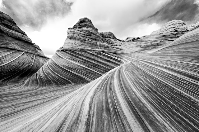
ANSEL ADAMS (1902-1984)
Vermilion Cliffs (944 m to 2164m - 3,100 to 7,100 feet.)
United States of America ( Arizona-Utah)
The site
The Vermilion Cliffs are the second "step" up in the five-step Grand
Staircase of the Colorado Plateau, in northern Arizona and southern
Utah. They extend west from near Page, Arizona, for a considerable
distance, in both Arizona and Utah. 112,500 acres (45,500 ha) of the
region were designated as the Paria Canyon-Vermilion Cliffs Wilderness
in 1984. An even greater area was protected within Vermilion Cliffs
National Monument in 2000. The Vermilion Cliffs are composed of the
resistant red sandstone beds of the Lower Jurassic Moenave and Kayenta
Formations. They are made up of deposited silt and desert dunes,
cemented by infiltrated carbonates and intensely colored by red iron
oxide and other minerals, particularly bluish manganese. They are in the
physiographic High Plateaus Section and Canyon Lands Section of the
Colorado Plateau Province. The Vermillion Cliffs were on an important
route from Utah to Arizona used by settlers during the 19th Century.
Present day U.S. Highway 89A basically follows the old wagon route past
the cliffs through House Rock Valley and up the Kaibab Plateau to Jacob
Lake.
Famous locations in the cliff area include Lee's Ferry, Glen Canyon and the Glen Canyon National Recreation Area, The Wave, Coyote Buttes, and others.
Reddish or vermilion-colored cliffs are found along U.S. Highway 89A
near Navajo Bridge, and may be seen from U.S. Highway 89 close to Bitter
Springs. Highway 89A runs alongside the Vermilion Cliffs for most of
its route between Jacob Lake and Marble Canyon, and offers a great view
of the cliffs.
The photographer
Ansel Easton Adams was an American photographer and environmentalist.
His black-and-white landscape photographs of the American West, especially Yosemite National Park, have been widely reproduced on calendars, posters, books, and the internet. Adams and Fred Archer developed the Zone System as a way to determine proper exposure and adjust the contrast of the final print. The resulting clarity and depth characterized his photographs. He primarily used large-format cameras because their high resolution helped ensure sharpness in his images. Adams founded the photography group known as Group f/64, along with fellow photographers Willard Van Dyke and Edward Weston and Imogen Cunningham.
In September 1941, Adams contracted with the Department of the Interior to make photographs of National Parks, Indian reservations, and other locations for use as mural-sized prints for decoration of the Department's new building. Part of his understanding with the Department was that he might also make photographs for his own use, using his own film and processing...
Full entry
___________________________________________
2021 - Wandering Vertexes...
by Francis Rousseau

No comments:
Post a Comment