google.com, pub-0288379932320714, DIRECT, f08c47fec0942fa0 GRAVIR LES MONTAGNES... EN PEINTURE: Search results for Thomas Hill
Showing posts sorted by date for query Thomas Hill. Sort by relevance Show all posts

Monday, April 22, 2024

LE GLACIER DAVIDSON PEINT PAR THOMAS HILL


THOMAS HILL (1829-1908) Le Glacier Davidson (7, 4 km) Etats Unis d'Amérique (Alaska)  In The Davidson Glacier, oil on board 1888, The Gilcrease Museum, Tulsa, Oklahoma

THOMAS HILL (1829-1908)
Le Glacier Davidson (7, 4 km)
Etats Unis d'Amérique (Alaska)

In The Davidson Glacier, oil on board 1888, The Gilcrease Museum, Tulsa, Oklahoma

Le peintre
Thomas Hill est un peintre américain du 19e siècle, qui réalisa de nombreux tableaux du paysage californien, en particulier de la Vallée de Yosemite, ainsi que des Montagnes Blanches (New Hampshire).Hill est un peintre proche de l'Hudson River School. Il resta très attaché à la peinture des Montagnes Blanches durant toute sa carrière ; on le voit à travers des tableaux comme Le Mont Lafayette en hiver. Hill acquit la technique de la peinture en plein air ; ces peintures, faites sur le terrain, servaient d'esquisses à des tableaux plus grands. L'arrivée en Californie en 1861 lui donna de nouveaux matériaux pour sa peinture. Il appréciait les vues et les paysages monumentaux, à l'instar de Yosemite. Durant sa vie, ses peintures furent populaires en Californie et pouvaient s'élever à 10 000 US$. Ses plus réussies sont celles du Great Canon of the Sierra, de Yosemite, des Vernal Falls et de Yosemite Valley. Sa Vue de la Vallée de Yosemite de 1865 fut choisie comme arrière-plan de la table principale lors du repas inaugural de l'Investiture de Barack Obama en 2009, pour commémorer la signature en 1864 par Abraham Lincoln du Yosemite Grant. Mais The Last Spike (1881) est son tableau le plus connu ; il représente la cérémonie de jonction à Promontory Summit entre les chemins de fer de l'Union Pacific Railroad et la Central Pacific Railroad, constituant ainsi le premier chemin de fer transcontinental des États-Unis. Il est exposé au California State Railroad Museum de Sacramento.

Le glacier
Le glacier Davidson est un glacier d'Alaska aux États-Unis situé dans le borough de Haines. Long de 7,4 km, il s'étend depuis le chaînon Chilkat (chaîne Saint-Élie) jusqu'à 42 km de Skagway. Son nom lui a été donné en 1867 par l'United States Geological Survey en l'honneur de George Davidson (1825-1911). Il représente actuellement une importante destination touristique des environs de Haines.

 ______________________________________

2024 - Gravir les montagnes en peinture
Un blog de Francis Rousseau


Friday, December 30, 2022

MONT DIABLO PEINT PAR WILLIAM KEITH


WILLIAM KEITH (1838-1911) Mont Diablo (1 ,173m - 3,648 ft) Etats-Unis (Californie)  In Sunset on Mount Diablo, 1877 ,Huile sur toile,  100.7 cm x 151.5 cm. Cantor Arts Center, Stanford University, Palo Alto CA


WILLIAM KEITH (1838-1911)
Mont Diablo (1 ,173m - 3,648 ft)
Etats-Unis (Californie)

In Sunset on Mount Diablo, 1877 Huile sur toile, 100.7 cm x 151.5 cm.
Cantor Arts Center, Stanford University, Palo Alto CA


Le peintre
William Keith était un peintre américano- écossais célèbre pour ses paysages californiens. Il est associé au tonalisme et à l'Ecole de Barbizon. Bien que la majeure partie de sa carrière se soit déroulée en Californie, il a c effectué deux longs voyages d'études en Europe et a eu un studio à Boston en 1871-72 et un à New York en 1880.
Dans les années 1870, Keith est arrivé en Californie, dans la vallée de Yosemite, avec une lettre de recommandation auprès de John Muir. Les deux hommes sont devenus de grands amis et cette amitié a perduré les 38 années du reste de leur vie . Tous deux étaient nés en Écosse la même année et partageaient un amour pour les montagnes de Californie. James Mitchell Clarke a décrit leur amitié comme une amitié "dans laquelle une affection et une admiration profondes s'exprimaient à travers une sorte de joute verbale, permanente ".
Au cours des années 1870, Keith a peint un certain nombre de grandes œuvres panoramiques dont Kings River Canyon (Oakland Museum) et California Alps (Mission Inn, Riverside). Ces oeuvre voulaient directement rivaliser avec celles de sujet similaires peint par Albert Bierstadt ou Thomas Hill.
"Mes images sont celles qui viennent de l'intérieur.de moi. Je ressens une émotion et je peins immédiatement une image qui l'exprime. Le sentiment est la valeur réelle dans mes images, et seules quelques personnes comprennent cela. Quiconque sait utiliser de la peinture et des pinceaux peut peindre une vraie scène de la nature - c'est une image objective. Mais pour un artiste digne de ce nom, tout doit cela doit venir de l'intérieur de lui même " .

La montagne
Le mont Diablo (1 ,173m - 3,648 ft) est une montagne située dans le comté de Contra Costa dans la région urbaine de San Francisco, au sud de la ville de Clayton et au nord-ouest de Danville. Ce sommet isolé est visible de l'ensemble de la baie de San Francisco et de nombreux endroits de la Californie du Nord. Le mont Diablo ressemble à une double pyramide sous de nombreux angles, et inclut plusieurs sommets secondaires, le plus important et le plus proche étant celui de l'autre moitié de ladite double pyramide, North Peak. Le sommet du mont Diablo est accessible aux véhicules motorisés, randonneurs ou cyclistes. Par temps clair, il est possible du sommet d'apercevoir le massif montagneux de la Sierra Nevada et la montagne de l'extrémité sud de la chaîne des Cascades, le volcan du pic Lassen, à environ 290 kilomètres. Le mont Shasta reste invisible du fait de la courbure terrestre, mais le Half Dome du parc national de Yosemite est lui visible par temps exceptionnellement clair grâce à un télescope.

 _________________________________________

2022 - Wandering Vertexes ....
            Errant au-dessus des Sommets Silencieux...
            Un blog de Francis Rousseau

Thursday, June 9, 2022

THE PIC DU MIDI D'OSSAU BY THOMAS ALLOM

THOMAS ALLOM (1804-1872) Le Pic du Midi d'Ossau  (2, 848m-9,462 ft) France ( Pyrénées)  In "Les Eaux Bonnes dans les Pyréneées ",vers 1840, Lithographié par J. Kernot

THOMAS ALLOM (1804-1872)
Le Pic du Midi d'Ossau  (2, 848m-9,462 ft)
France ( Pyrénées)

In "Les Eaux Bonnes dans les Pyréneées ",vers 1840, Lithographed by J. Kernot


The mountain
The Pic du Midi d'Ossau (2, 848m-9,462 ft) not to be confused with the Pic du Midi de Bigorre is a mountain rising above the Ossau Valley in the French Pyrenees. Despite possessing neither a glacier nor, in the context of the range, a particularly high summit, its distinctive shape makes it a symbol of the French side of the Pyrenees. This familiar shape also makes it easily recognisable from afar, and it is particularly distinctive from the Boulevard des Pyrénées in Pau, some 55 km to the north.
The Pic du Midi d'Ossau lies within the commune of Laruns, in the département of Pyrénées Atlantiques and the Aquitaine region of France. It lies within the fully protected area of the Pyrenees National Park. As normally seen from the north, the mountain presents itself as having two distinct peaks, although from the south two other summits are also visible. It stands separate from any surrounding peaks, being largely surrounded by the valleys of the Gave de Bious, to the west, and the Gave du Brousset, to the east. These two mountain streams come together in the hamlet of Gabas at the foot of the mountain's northern slopes, to form the Gave d'Ossau.
The valley of Ossau is placed in the Béarnaises Pyrénées, between la vallée d'Aspe and the Vallée de Gavarnie, from Rébénacq to the French-Spanish frontier (Col du Portalet). The Col d'Aubisque closes the valley to the east. The villages (from N to S) of the high Ossau are: Bilhères, Bielle, Béon, Bélesten, Gère-Bélesten, Aste-Béon, Louvie-Soubiron, Béost, Assouste, Aas, Laruns, Eaux-Bonnes, Gourette, Eaux-Chaudes, Goust, Gabas, Arouste-Fabréges and Pont de Camps.
The Pic du Midi d'Ossau was reputedly first climbed in 1552 by an expedition led by François de Foix-Candale, later to become the Bishop of Aire. Although the success of this first climb is disputed, it is known that the mountain had been successfully climbed by 1787 when a military surveyor noted that a triangulation cairn had been built on the summit. The first fully recorded climb was by Guillaume Delfau accompanied by Mathieu (a shepherd from Eaux-Bonnes) on October 2, 1797.
The mountain offers many routes of ascent; the voie normale is a serious scramble and rock climb with a grading of PD, II+, 550 m. It approaches the summit via the Refuge de Pombie, a Club Alpin Français owned mountain hut situated at 2,031 m - 6,663 ft, and requires most of a day to execute.
Two others refuges : Cabane Pyrenea Sports belonging to Société Pyrénées Sports at Pau, 25 places located on the NE shore of Lac de Bious-Artigues, and Cabane de Peyreget (1.950 m)
non guarded, 4 places located near Lac de Peyreget and W of Peyreget' little peak ridge.

 The artist
Thomas Allom was an English architect, artist, and topographical illustrator. He was a founding member of what became the Royal Institute of British Architects (RIBA). He designed many buildings in London, including the Church of St Peter's and parts of the elegant Ladbroke Estate in Notting Hill. He also worked with Sir Charles Barry on numerous projects, most notably the Houses of Parliament, and is chiefly known for his numerous topographical works, which were used to illustrate books on travel. From the 1820s onwards, he travelled extensively through the UK and mainland Europe. In 1832 he published Westmorland, Durham and Northumberland Illustrated from Original Drawings (three volumes). In 1834 Allom arrived in Istanbul, Turkey, and produced hundreds of drawings during journeys through Anatolia, Syria and Palestine. The results of this expedition were published in 1838 in Constantinople and the Scenery of the Seven Churches of Asia Minor published in two volumes with text by Robert Walsh.  He is also remembered for numerous illustrations of China, published in China Illustrated in 1845. He also provided illustrations for "Family Secrets" by Mrs Ellis (1841) and E W Brayley's "A topographical history of Surrey" (1850).

___________________________
2022 - Wandering Vertexes
Un blog de Francis Rousseau


Friday, February 25, 2022

MOUNT SNOWDON PAINTED BY ALFRED DE BREANSKI Sr

ALFRED DE BREANSKI Sr. (1852-1928) Mount Snowdon (1, 085 m -3,560 ft) United Kingdom (Wales)  In Mount Snowdon at midnight,  oil on canvas, 50x72cm- Private collection

ALFRED DE BREANSKI Sr. (1852-1928)
Mount Snowdon (1, 085 m -3,560 ft)
United Kingdom (Wales)

In Mount Snowdon at midnight,  oil on canvas, 50x72cm- Private collection


The mountain
Mount Snowdon (1, 085 m -3,560 ft),Yr Wyddfa in welsh, is the highest mountain in Wales and the highest point in the British Isles south of the Scottish Highlands. A 1682 survey estimated that the summit of Snowdon was at a height of 1,130 m - 3,720 feet ; in 1773, Thomas Pennant quoted a later estimate of 1,088 m- 3,568 ft above sea level at Caernarfon. Recent surveys give the height of the summit as 1,085 m -3,560 ft. The name Snowdon is from the Old English for "snow hill", while the Welsh name – Yr Wyddfa – means "the tumulus" or "the barrow", which may refer to the cairn thrown over the legendary giant Rhitta Gawr after his defeat by King Arthur. As well as other figures from Arthurian legend, the mountain is linked to a legendary Afanc (water monster) and the Tylwyth Teg (fairies). Mount Snowdon is located in Snowdonia National Park (Parc Cenedlaethol Eryri) in Gwynedd. It has been described as "probably the busiest mountain in Britain", with approximately 444,000 people having walked up the mountain in 2016. It is designated as a national nature reserve for its rare flora and fauna. The rocks that form Snowdon were produced by volcanoes in the Ordovician period, and the massif has been extensively sculpted by glaciation, forming the pyramidal peak of Snowdon and the Arêtes of Crib Goch and Y Lliwedd. The cliff faces on Snowdon, including Clogwyn Du'r Arddu, are significant for rock climbing, and the mountain was used by Edmund Hillary in training for the 1953 ascent of Mount Everest.
The summit can be reached by a number of well-known paths, and by the Snowdon Mountain Railway, a rack and pinion railway opened in 1896 which carries passengers the 4.7 miles (7.6 km) from Llanberis to the summit station.

The painter
Alfred de Breanski Sr. is a British landscape painter best known for his idyllic but realistic depictions of rural Scotland and Wales. Thanks to the particular attention paid to the multiple textures, light and colouristic qualities of each landscape, it is evident that Breanski is deeply influenced by the work of John Constable. It is also inspired by the dramatic nature of the Scottish countryside such as the Highlands, noted for their stark beauty and spectacular scenery. Born in 1852 in Greenwich, England, he exhibited his works at the Royal Academy in London from 1872 to 1918. Today, his works are in the collections of the Southampton City Art Gallery, the Laing Art Gallery in Newcastle and museums Brighton & Hove in East Sussex. De Breanski died in London in 1928.

_______________________________

2022 - Wandering Vertexes...
by Francis Rousseau

Sunday, October 24, 2021

ILLINIZAS VOLCANOES SKETCHED BY FREDERIC EDWIN CHURCH (1826-1900)

FREDERIC EDWIN CHURCH (1826-1900), Illiniza Sur  (5,248 m-17, 218ft) Illiniza Norte 5,126 m-16, 818ft) Ecuador   In Mount Iliniza, Ecuador, July 3, 1857,  Graphite, brush and white gouache on green paper, 31.1 x 43.2 cm, Smithsonian / Cooper Hewitt, Smithsonian Design Museum

FREDERIC EDWIN CHURCH (1826-1900),
Illiniza Sur  (5,248 m-17, 218ft)
Illiniza Norte 5,126 m-16, 818ft)
Ecuador

 In Mount Iliniza, Ecuador, July 3, 1857,  Graphite, brush and white gouache on green paper, 31.1 x 43.2 cm, Smithsonian / Cooper Hewitt, Smithsonian Design Museum 


The volcanoes
The Illinizas are a pair of volcanic mountains that are located to the south of Quito, Ecuador. They are located in the Illinizas Ecological Reserve (Reserva Ecológica Los Illinizas). These twin mountains are separated by a saddle that is about a kilometer long. The peaks are among the highest in Ecuador, with Illiniza Sur (5248 m-17, 218ft) standing slightly taller than Illiniza Norte 5126 m- 16, 818ft) its northern counterpart.
Most guidebooks (for example, Lonely Planet Ecuador, Ecuador: A Climbing Guide) spell the mountain with only one "l" as in Iliniza. The name Illinizas is derived from the Kunza words for "masculine hill."
Whilst Illiniza Sur (the southern peak) is a more difficult climb due to its glacial nature, Illiniza Norte requires little or no climbing expertise, and may be climbed as a trekking peak. A guide is still recommended, however, as the path becomes hard to navigate as it approaches the summit.
The Illinizas are excellent mountains for acclimatization to altitude, and are frequently used as a preparatory climb to higher peaks such as Cotopaxi, Chimborazo and Cayambe.
There is a rustic refuge located between the north and south peaks. It can be reached in one hour by car from El Chaupi, followed by a three-hour climb. The refuge has gas stoves, pots and pans and bunk beds. It is necessary to bring warm sleeping bags and food, but water is available to be boiled. The Englishman Edward Whymper tried and failed twice to make the first ascent of Iliniza Sur. It was climbed for the first time in 1880 by his two Italian guides Jean-Antoine Carrel and Louis Carrel. The first ascent of Iliniza Norte was made in 1912 by the Ecuadorians Nicolás Martínez and Alejandro Villavicencio.


The painter

Frederic Edwin Church was an American landscape painter born in Hartford, Connecticut. He was a central figure in the Hudson River School of American landscape painters, perhaps best known for painting large panoramic landscapes, often depicting mountains, waterfalls, and sunsets, but also sometimes depicting dramatic natural phenomena that he saw during his travels to the Arctic and Central and South America. Church's paintings put an emphasis on light and a romantic respect for natural detail. In his later years, Church painted classical Mediterranean and Middle Eastern scenes and cityscapes.
Church was the product of the second generation of the Hudson River School and the pupil of Thomas Cole, the school’s founder. The Hudson River School was established by the British Thomas Cole when he moved to America and started painting landscapes, mostly of mountains and other traditional American scenes. Both Cole and Church were devout Protestants and the latter's beliefs played a role in his paintings especially his early canvases. Church did differ from Cole in the topics of his paintings: he preferred natural and often majestic scenes over Cole's propensity towards allegory.
Church, like most second generation Hudson River School painters, used extraordinary detail, romanticism, and luminism in his paintings. Romanticism was prominent in Britain and France in the early 1800s as a counter-movement to the Enlightenment virtues of order and logic. Artists of the Romantic period often depicted nature in idealized scenes that depicted the richness and beauty of nature, sometimes also with emphasis on the grand scale of nature.
This tradition carries on in the works of Frederic Church, who idealizes an uninterrupted nature, highlighted by creating excruciatingly detailed art. The emphasis on nature is encouraged by the low horizontal lines, and preponderance of sky to enhance the wilderness; humanity, if it is represented, is depicted as small in comparison with the greater natural reality. The technical skill comes in the form of luminism, a Hudson River School innovation particularly present in Church's works. Luminism is also cited as encompassing several technical aspects, which can be seen in Church’s works. One example is the attempt to “hide brushstrokes,” which makes the scene seem more realistic and lessen the artist’s presence in the work. Most importantly is the emphasis on light (hence luminism) in these scenes. The several sources of light create contrast in the pictures that highlights the beauty and detailed imagery in the painting.

___________________________________________
2021 - Wandering Vertexes...
by Francis Rousseau


Wednesday, September 1, 2021

MOUNT SNOWDON PAINTED BY J.M.W. TURNER


J.M.W. Turner (1775-1851), Mount Snowdon (1, 085 m -3,560 ft), United Kingdom (Wales),  In  "Mount Snowdon, Afterglow ", oil on canvas, 1800, Tate 
 
J.M.W. Turner (1775-1851)
Mount Snowdon (1, 085 m -3,560 ft)
United Kingdom (Wales)

In Mount Snowdon, Afterglow, oil on canvas, 1800, Tate

The mountain
Mount Snowdon (1, 085 m -3,560 ft),Yr Wyddfa in welsh, is the highest mountain in Wales and the highest point in the British Isles south of the Scottish Highlands. A 1682 survey estimated that the summit of Snowdon was at a height of 1,130 m - 3,720 feet ; in 1773, Thomas Pennant quoted a later estimate of 1,088 m- 3,568 ft above sea level at Caernarfon. Recent surveys give the height of the summit as 1,085 m -3,560 ft. The name Snowdon is from the Old English for "snow hill", while the Welsh name – Yr Wyddfa – means "the tumulus" or "the barrow", which may refer to the cairn thrown over the legendary giant Rhitta Gawr after his defeat by King Arthur. As well as other figures from Arthurian legend, the mountain is linked to a legendary Afanc (water monster) and the Tylwyth Teg (fairies). Mount Snowdon is located in Snowdonia National Park (Parc Cenedlaethol Eryri) in Gwynedd. It has been described as "probably the busiest mountain in Britain", with approximately 444,000 people having walked up the mountain in 2016. It is designated as a national nature reserve for its rare flora and fauna. The rocks that form Snowdon were produced by volcanoes in the Ordovician period, and the massif has been extensively sculpted by glaciation, forming the pyramidal peak of Snowdon and the Arêtes of Crib Goch and Y Lliwedd. The cliff faces on Snowdon, including Clogwyn Du'r Arddu, are significant for rock climbing, and the mountain was used by Edmund Hillary in training for the 1953 ascent of Mount Everest.
The summit can be reached by a number of well-known paths, and by the Snowdon Mountain Railway, a rack and pinion railway opened in 1896 which carries passengers the 4.7 miles (7.6 km) from Llanberis to the summit station.

The painter
The english painter Joseph Mallord William Turner was considered a controversial figure in his day, but is now regarded as the artist who elevated landscape painting to an eminence in the history of painting. Although renowned for his oil paintings, Turner is also one of the greatest masters of British watercolour landscape painting.  He is commonly known as "the painter of light" and his work is regarded as a Romantic preface to Impressionism.
In his thirties, Turner travelled widely in Europe, starting with France and Switzerland in 1802 and studying in the Louvre in Paris in the same year. He made many visits to Venice.  Turner's talent was recognized early in his life. Financial independence allowed Turner to innovate freely; his mature work is characterized by a chromatic palette and broadly applied atmospheric washes of paint. According to David Piper's The Illustrated History of Art, his later pictures were called "fantastic puzzles:" Turner was recognized as an artistic genius: influential English art critic John Ruskin described him as the artist who could most "stirringly and truthfully measure the moods of Nature."
Turner's major venture into printmaking was the Liber Studiorum (Book of Studies), seventy prints that he worked on from 1806 to 1819. The Liber Studiorum was an expression of his intentions for landscape art. The idea was loosely based on Claude Lorrain's Liber Veritatis (Book of Truth), where Lorrain had recorded his completed paintings; a series of print copies of these drawings, by then at Devonshire House, had been a huge publishing success. Turner's plates were meant to be widely disseminated, and categorized the genre into six types: Marine, Mountainous, Pastoral, Historical, Architectural, and Elevated or Epic Pastoral. His printmaking was a major part of his output, and a museum is devoted to it, the Turner Museum in Sarasota, Florida, founded in 1974 by Douglass Montrose-Graem to house his collection of Turner prints.
Turner placed human beings in many of his paintings to indicate his affection for humanity on the one hand (note the frequent scenes of people drinking or working or walking in the foreground), but its vulnerability and vulgarity amid the 'sublime' nature of the world on the other. 'Sublime' here means awe-inspiring, savage grandeur, a natural world unmastered by man, evidence of the power of God – a theme that romanticist artists and poets were exploring in this period. Although these late paintings appear to be 'impressionistic' and therefore a forerunner of the French school, Turner was striving for expression of spirituality in the world, rather than responding primarily to optical phenomena.
Turner used pigments like carmine in his paintings, knowing that they were not long-lasting, despite the advice of contemporary experts to use more durable pigments. As a result, many of his colours have now faded greatly.
John Ruskin says in his "Notes" on Turner in March 1878 : "His true master was Dr Monro; to the practical teaching of that first patron and the wise simplicity of method of watercolour study, in which he was disciplined by him and companioned by Girtin, the healthy and constant development of the greater power is primarily to be attributed; the greatness of the power itself, it is impossible to over-estimate. "

_______________________________
2021 - Wandering Vertexes...
by Francis Rousseau

Sunday, August 22, 2021

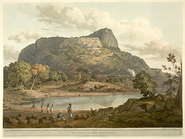
RAYAKOTTAI BY HENRY SALT


HENRY SALT (1780-1827) Rayakottai (No elevation data) India (Tamil Nadu)  In " Riacotta in the Baramahal,' aquatint, from

HENRY SALT (1780-1827)
Rayakottai (No elevation data)
India (Tamil Nadu)

In " Riacotta in the Baramahal,' aquatint, 1806, from  
Twenty Four Views in St. Helena, the Cape, India, Ceylon, the Red Sea, Abyssinia and Egypt, 
 The British Library


About the plate
This aquatint was taken from plate 12 of Henry Salt's Twenty Four Views in St. Helena, the Cape, India, Ceylon, the Red Sea, Abyssinia and Egypt. Salt visited Rayakottai in Tamil Nadu on his way to the Cauvery Falls. Viscount Valentia George Annesley wrote of its importance as a point of communication between Mysore and the Carnatic: "[Governor General] Lord Cornwallis ... had the fortifications strengthened. At present they consist of the hill, whose top is only approachable by a narrow flight of steps, and a fort at the bottom where are very comfortable houses for the officers. The scenery is wild and abrupt, consisting of rocky hills, with woods and jungle between ... the climate is so moderate, that every kind of fruit and vegetable may be reared in a degree of perfection that is unknown on the sultry plains around Madras.". For some reason, this impressed the british  by the fact it was " as high as a mountain". So.... do I year mountain ?

The place
Rayakottai, also spelled Rayakotta is not not really what we can alled a mountain, but a hill or a ridge like there are many others in this blog.  In reality it is a fort ! But it is designed quite like a mountain !!! It is located neat a town in Denkanikottai taluk, Krishnagiri District, Tamil Nadu, India. It is 73 kilometres (45 mi) from Bangalore.  The fort was built by King Krishna deverayar and situated within the town of Rayakottai which is one of the ancient fortress in the Krishnagiri district. It is now one of the protected monument by the Archaeological Survey of India. In the 18th century Hyder Ali and Tipu sultan captured this fort. The fort was captured by Major Gowdie during the third Anglo-Mysore War in 1791. According to the Treaty of Srirangapatna, this fort came into the hands of the British. 

The artist
Henry Salt was an English artist, traveller, collector of antiquities, diplomat, and Egyptologist.
After a time as a portrait painter, Salt was permitted to travel with the English nobleman George Annesley, Viscount Valentia as his secretary and draughtsman after being recommended by Thomas Simon Butt. They started on an eastern tour in June 1802, traveling on the British East India Company's extra (chartered) ship Minerva to India via the Cape Colony. In 1805, Valentia sent Salt on a journey into the Abyssinian area (now Ethiopia) to meet with the ras of Tigré to open up trade relations on behalf of the English. While visiting there, Salt gained the respect of the ras. He returned to England on 26 October 1806. His journey home took him through Egypt where he met the pasha Mehmet Ali. Salt's paintings from the trip were used in Valentia's Voyages and Travels to India, published in 1809. The originals of all the drawings were kept by Valentia, as also the copper plates after Salt's death. The format and style of the plates is similar to Thomas and William Daniell's work, "Oriental Scenery" (1795-1808).
Salt returned to Ethiopia in 1809 on a government mission to explore trade and diplomatic links with the Tigrayan warlord Ras Wolde Selassie. Upon arrival, he was unable to meet with the king due to unrest in the country, so instead he went to stay with his friend the ras of Tigré. During this venture, Salt took on the side mission of verifying and correcting the information about the region reported by the Scottish traveler, James Bruce many years earlier. Salt came back to England in 1811 with numerous specimens of both plants and animals.

___________________________________________
2021 - Wandering Vertexes...
by Francis Rousseau


Sunday, January 10, 2021

MOUNT SNOWDON FROM LLYN Y DDINAS BY SIDNEY RICHARD PERCY


https://wanderingvertexes.blogspot.com/2021/01/mount-snowdon-from-llyn-y-ddinas-by.html

SIDNEY RICHARD PERCY (1821-1886)
Mount Snowdon (1, 085 m -3,560 ft)
United Kingdom (Wales)

In Llyn-y-Ddinas, North Wales, Mount Snowdon in the background (1873), Oil on canvas, 45.5 x 76 cm. Private Collection

 
The mountain
Mount Snowdon (1, 085 m -3,560 ft),Yr Wyddfa in welsh, is the highest mountain in Wales and the highest point in the British Isles south of the Scottish Highlands. A 1682 survey estimated that the summit of Snowdon was at a height of 1,130 m - 3,720 feet ; in 1773, Thomas Pennant quoted a later estimate of 1,088 m- 3,568 ft above sea level at Caernarfon. Recent surveys give the height of the summit as 1,085 m -3,560 ft. The name Snowdon is from the Old English for "snow hill", while the Welsh name – Yr Wyddfa – means "the tumulus" or "the barrow", which may refer to the cairn thrown over the legendary giant Rhitta Gawr after his defeat by King Arthur. As well as other figures from Arthurian legend, the mountain is linked to a legendary Afanc (water monster) and the Tylwyth Teg (fairies). Mount Snowdon is located in Snowdonia National Park (Parc Cenedlaethol Eryri) in Gwynedd. It has been described as "probably the busiest mountain in Britain", with approximately 444,000 people having walked up the mountain in 2016. It is designated as a national nature reserve for its rare flora and fauna. The rocks that form Snowdon were produced by volcanoes in the Ordovician period, and the massif has been extensively sculpted by glaciation, forming the pyramidal peak of Snowdon and the Arêtes of Crib Goch and Y Lliwedd. The cliff faces on Snowdon, including Clogwyn Du'r Arddu, are significant for rock climbing, and the mountain was used by Edmund Hillary in training for the 1953 ascent of Mount Everest.
The summit can be reached by a number of well-known paths, and by the Snowdon Mountain Railway, a rack and pinion railway opened in 1896 which carries passengers the 4.7 miles (7.6 km) from Llanberis to the summit station.

The painter
Sidney Richard Percy had his greatest success painting landscapes of grazing cattle, typically set against backgrounds of distant mountains and cloudy skies. The prevailing hues of his landscapes are earth tones and soft greens, accentuated by a variety of pastel hues. The detail in his work is part of its appeal, and "it was remarked that his rocks and stones were sufficiently accurate to have served as illustrations to the writings of Sir Roderick Murchison, the popular 19th-century geologist." Llyn-y-Ddinas, North Wales, (see above) one of his more popular works on the internet, displays these qualities. He also painted landscapes of farm fields, wheel-rutted country roads, and the occasional boat scene on a lake. Although he generally painted in oils, a number of small watercolors on cardboard exist, typically unsigned, that are his work. The family, and his son the painter Herbert Sidney Percy in particular, referred to these as "potboilers", meaning that they were quickly, and often crudely executed, yet easily and cheaply sold "to put food on the table" when working on larger, more time-consuming oils for exhibition, or commissions. Many of these watercolor "potboilers" were done in the field, and then brought back to the studio to refer to when executing a more formal oil on canvas.
Sidney Richard Percy was extremely popular during the early part of his career, which for a short time brought him a fair amount of income. Among his patrons during this time was Prince Albert the Royal consort who in 1854 gave Percy's landscape of A view of Llyn Dulyn, North Wales, which had just been exhibited at the Royal Academy, as a gift to his wife Queen Victoria. This painting still hangs today in the Royal Collection. Unfortunately Sidney Richard Percy outlived his popularity, and the art world was more excited about impressionism and other styles than landscapes when he died. Today though, his work is much sought after, and his better paintings bring much higher prices in auction than any of those of his brethren in the Williams family.
When the Athenaeum in 1886 (i. 592) ran an obituary for Sidney Richard Percy they called him, "the well-known and popular painter, founder of the so-called School of Barnes . . ." Although depending on the context of what is meant by the so-called Barnes School, this is a bit of an injustice to his father Edward Williams, whom it might be argued is the founder of the Barnes School of painters, but it illustrates the popularity that Sidney Richard Percy held with the art-buying public of his day.

__________________________________________

2021 - Wandering Vertexes / Mountain paintings
By Francis Rousseau

Sunday, December 20, 2020

KLOOF CORNER/TABLE MOUNTAIN PAINTED BY NITA SPILHAUS


https://wanderingvertexes.blogspot.com/2020/12/kloof-cornertable-mountain-painted-by.html

NITA SPILHAUS (1878-1967)
Kloof Corner in Table mountain / Hoerikwaggo (1,085 m - 3,558 ft) 
South Africa


In Klooof Corner, oil on canvas, 1920, Private collection

The mountain
Kloof Corner follows a prominent ridge the forms the right skyline of Table Mountain (1,085 m - 3,558 ft)   when viewed from the north – the iconic and best-known view of Table Mountain. The ridge terminates about 150 meters below the summit at the foot of sheer cliffs, from where you latch onto the India Venster route to gain the summit via a lengthy traverse to the back of the Table. As far as Table Mountain hiking goes, Kloof Corner is one of the more challenging routes. The route contains 3 chains to assist hikers up tricky rock bands; these should not be underestimated. A variation exists along the middle section, known as Kloof Corner Pinnacle and strictly adhering to the crest of the ridge to rejoin the original line further up. Great to do if you have time and want more scrambling and adventure.  A unique feature of the route is that it offers views towards the north (over the city) and the west (Camps Bay / Atlantic coast) at the same time at several points along the way. The ridge, known as Kloof Corner Ridge (a route name consisting of 3 nouns!) forms the great northwestern corner of the mountain, where the north and west sides meet. It’s one of the most conspicuous features on Table Mountain.
Table Mountain (1,085 m - 3,558 ft)  also called Hoerikwaggo is a flat-topped mountain forming a prominent landmark overlooking the city of Cape Town in South Africa and forming part of the Table Mountain National Park. The main feature of Table Mountain is the level plateau approximately 3 kilometres (2 mi) from side to side, edged by impressive cliffs. The plateau, flanked by Devil's Peak to the east and by Lion's Head to the west, forms a dramatic backdrop to Cape Town. This broad sweep of mountainous heights, together with Signal Hill, forms the natural amphitheatre of the City Bowl and Table Bay harbour. The highest point on Table Mountain is towards the eastern end of the plateau and is marked by Maclear's Beacon, a stone cairn built in 1865 by Sir Thomas Maclear for trigonometrical survey. It is 1,086 metres (3,563 ft) above sea level, about 19 metres (62 ft) higher than the cable station at the western end of the plateau.

 The painter
Nita Spilhaus born Pauline Augusta Wilhelmina Spilhaus was a Portuguese-born South African painter, working in oil, watercolour and pastel. She is best known for her landscapes, paintings and etchings of trees, her portrayals of the Cape mountains, and depictions of the Malay Quarter.
Nita was raised by her grandfather in Lübeck, and her first training in drawing and etching took place at the Lübeck School of Art, then in Munich, where she attended a private art school run by Friedrich Fehr, the Dachau art colony just outside Munich under Adolf Hölzel, and copper engraving under Heinrich Wolff.
She moved to South Africa in 1907 because of the death of her grandfather in 1906, joining her brother Karl, and the family of her uncle Arnold Wilhelm Spilhaus.
She joined the 'South African Society of Artists' soon after her arrival. The Cape Times acknowledged her talent as a graphic artist by publishing a modest booklet of 12 etchings portraying scenes in and around Cape Town.
Working from a studio in Keerom Street in Cape Town she gradually became a leading member of Cape Town's art community. When Hugo Naudé visited Munich in 1913 she took over his art classes in Worcester.
Her oil paintings were Impressionist in style, her landscapes rich in atmosphere, while her flower studies are notable for their vivid colours. She had a particular affinity with trees and her striking images of the Stone Pines around Cape Town are a recurring theme in her work.

___________________________________________

2020 - Wandering Vertexes...
by Francis Rousseau

Sunday, October 25, 2020

MUIR GLACIER PAINTED BY THOMAS HILL

THOMAS HILL (1829-1908) Muir Glacier (90 m - 200 ft) United States of America ( Alaska)


THOMAS HILL (1829-1908)
Muir Glacier (90 m - 200 ft)
United States of America ( Alaska)

In Muir Glacier, Alaska. oil on canvas, Oakland Museum of California

The Glacier
Muir Glacier is a glacier in Glacier Bay National Park and Preserve in the U.S. state of Alaska. It is currently about 0.7 km (0.43 mi) wide at the terminus. As recently as the mid-1980s the glacier was a tidewater glacier and calved icebergs from a wall of ice 90 m (200 feet) tall.
The glacier is named after Scottish-born naturalist John Muir, who traveled around the area and wrote about it, generating interest in the local environment and in its preservation. His first two visits were in 1879 (at age 41) and 1880. During the visits, he sent an account of his visits in installments to the San Francisco Bulletin. Later, he collected and edited these installments in a book, Travels in Alaska, published in 1915, the year after he died.
Muir Glacier has undergone very rapid, well-documented retreat since its Little Ice Age maximum position at the mouth of Glacier Bay around 1780. In 1794, the explorer Captain George Vancouver found that most of Glacier Bay was covered by an enormous ice sheet, some 1,200 meters (3,900 ft) in places.
In 1904 the glacier reportedly "broke through the mountains" with Pyramid Peak to the west and Mt. Wright and Mount Case to the east.
From 1892 to approximately 1980, it had retreated nearly 32 kilometers (20 mi). Between 1941 and 2004, the glacier retreated more than 12 kilometers (7.5 mi) and thinned by over 800 meters (2,600 ft). Ocean water has filled the valley replacing the ice and creating Muir Inlet.


The painter
Thomas Hill was an American artist of the 19th century. He produced many fine paintings of the California landscape, in particular of the Yosemite Valley, as well as the White Mountains of New Hampshire. Hill’s work was often driven by a vision resulting from his experiences with nature. For Thomas Hill, Yosemite Valley and the White Mountains of New Hampshire were his sources of inspiration to begin painting and captured his direct response to nature.
Hill was loosely associated with the Hudson River School of painters. The Hudson River School celebrated nature with a sense of awe for its natural resources, which brought them a feeling of enthusiasm when thinking of the potential it held. Mainly the earlier members of the Hudson River School, around the 1850-60’s, displayed man as in unison with nature in their landscape paintings by often painting men on a very small scale compared to the vast landscape. Thomas Hill often brought this technique into his own paintings in for example in his painting, Yosemite Valley, 1889.
He made early trips to the White Mountains with his friend Benjamin Champney and painted White Mountain subjects throughout his career. An example of his White Mountain subjects is Mount Lafayette in his Mount Lafayette in Winter.
Hill acquired the technique of painting en plein air. These paintings in the field later served as the basis for larger finished works. In plein air means to “paint outdoors and directly from the landscape”,[ which Hill incorporated into many of his paintings. Hill’s landscape paintings demonstrate how he combined his powers of observation with powerful motifs in each painting.
Hill’s move to California in 1861 brought him new material for his paintings. He chose monumental vistas, like Yosemite. During his lifetime, Hill’s paintings were popular in California, costing as much as $10,000. Hill's best works are considered to be these monumental subjects, including Great Canyon of the Sierra, Yosemite, Vernal Falls and Yosemite Valley.

___________________________________________

2020 - Wandering Vertexes...
by Francis Rousseau

Wednesday, October 14, 2020

TETON RANGE PAINTED BY THOMAS MORAN

THOMAS MORAN (1837-1926) Grand Teton (4,199 m - 13,775 ft) United States of America (Wyoming)  In Teton range, Oil on cnavas, 1897, 76.2 x 114.3 cm, The MET, (on view on Gallery 765)

THOMAS MORAN (1837-1926)
Grand Teton (4,199 m - 13,775 ft)
United States of America (Wyoming)

In Teton range, Oil on cnavas, 1897, 76.2 x 114.3 cm, The MET, (on view on Gallery 765)

 About this painting in the MET note
" As Albert Bierstadt claimed the Rocky Mountains and the Sierra Nevada for his art, so Moran made the Yellowstone region and the Grand Canyon his signature subjects. His dazzling watercolors of Yellowstone led directly to its designation, in 1872, as the first national park. A native of Great Britain and an ardent admirer of the English painter J. M. W. Turner, Moran used prismatic color to capture the splendors of the American West—such as this dramatic view of the Tetons, located just south of Yellowstone. For centuries, Indigenous communities lived on and cared for this land, yet they are notably absent from Moran’s work. Instead, the artist depicted the landscape as an untouched pre-industrial paradise—thus, ripe for White settlement and colonization "


The mountain
Grand Teton (4,199 m - 13,775 ft) is the highest mountain in Grand Teton National Park in Northwest Wyoming, and a classic destination in American mountaineering. It is the highest point of the Teton Range, and the second highest peak in the U.S. state of Wyoming after Gannett Peak. The mountain is entirely within the Snake River drainage basin, which it feeds by several local creeks and glaciers.The Teton Range is a subrange of the Rocky Mountains, which extend from southern Alaska to northern New Mexico.  Grand Teton's name was first recorded as Mount Hayden by the Washburn-Langford-Doane Expedition of 1870. However, the name "the Grand Teton" had early currency. The Edition of April, 1901 of the USGS 1:125,000 quadrangle map of the area shows "Grand Teton" as the name of the peak. A United States National Park named "Grand Teton National Park" was established by law in 1929. By 1931, the name Grand Teton Peak was in such common usage that it was recognized by the USGS Board on Geographic Names. Another shift in usage led the Board to shorten the name on maps to Grand Teton in 1970. The origin of the name is disputed. The most common explanation is that "Grand Teton" means "large teat" in French, named by either French-Canadian or Iroquois members of an expedition led by Donald McKenzie of the North West Company. However, other historians disagree, and claim that the mountain was named after the Teton Sioux tribe of Native Americans.

The painter

Thomas Moran was an American painter and printmaker of the Hudson River School in New York whose work often featured the Rocky Mountains. Moran and his family took residence in New York where he obtained work as an artist. He was a younger brother of the noted marine artist Edward Moran, with whom he shared a studio. A talented illustrator and exquisite colorist, Thomas Moran was hired as an illustrator at Scribner's Monthly. During the late 1860s, he was appointed the chief illustrator for the magazine, a position that helped him launch his career as one of the premier painters of the American landscape, in particular, the American West.
Moran along with Albert Bierstadt, Thomas Hill, and William Keith are sometimes referred to as belonging to the Rocky Mountain School of landscape painters because of all of the Western landscapes made by this group.
Thomas Moran has a painting exhibited as part of the White House collection with The Three Tetons painted in 1895.

_____________________________

2020 - Wandering Vertexes...
by Francis Rousseau

Saturday, October 3, 2020

MOUNT LANGI PAINTED BY EUGENE VON GUERARD


EUGENE VON GUERARD (1811-1901) Mount Langi Ghiran (924 m - 3,031ft) Australia (Victoria)  In Mount Langi from Pleasant Creek oil on canvas, 1890

EUGENE VON GUERARD (1811-1901)
Mount Langi Ghiran (924 m - 3,031ft)
Australia (Victoria)

In Mount Langi from Pleasant Creek oil on canvas, 1890


The mountain
Mount Langi Ghiran (924m - 3,031ft) is located in the west of Victoria southeast of Australia. The nearest town to Mount Langi Ghiran is Ararat about 16.3 km away.
The first European to climb Mount Langi Ghiran was Major Thomas Mitchell, on his 1836 'Australia Felix' expedition. He first named it Mount Mistake !
There are two reservoirs in the park which were built from local granite blocks in the 1880s. The main reservoir forms part of Ararat's water supply and is worth a visit.
A "spot mill" for extracting timber was built on the northern slopes in 1940 but was short lived. Today little evidence remains to remind us of the mill's past operation.
Since 1970, famous vineyards are situated in the valley of Mount Langi Ghiran.

The painter

Johann Joseph Eugene von Guerard was an Austrian-born artist, active in Australia from 1852 to 1882. Known for his finely detailed landscapes in the tradition of the Düsseldorf school of painting, he is represented in Australia's major public galleries, and is referred to in the country as Eugene von Guerard. In 1852 von Guerard arrived in Victoria, Australia, determined to try his luck on the Victorian goldfields. As a gold-digger he was not very successful, but he did produce a large number of intimate studies of goldfields life, quite different from the deliberately awe-inspiring landscapes for which he was later to become famous. Realizing that there were opportunities for an artist in Australia, he abandoned the diggings and was soon undertaking commissions recording the dwellings and properties of wealthy pastoralists.
By the early 1860s, von Guerard was recognized as the foremost landscape artist in the colonies, touring Southeast Australia and New Zealand in pursuit of the sublime and the picturesque. He is most known for the wilderness paintings produced during this time, which are remarkable for their shadowy lighting and fastidious detail. Indeed, his View of Tower Hill in south-western Victoria was used as a botanical template over a century later when the land, which had been laid waste and polluted by agriculture, was systematically reclaimed, forested with native flora and made a state park. The scientific accuracy of such work has led to a reassessment of von Guerard's approach to wilderness painting, and some historians believe it likely that the landscapist was strongly influenced by the environmental theories of the leading scientist Alexander von Humboldt. Others attribute his 'truthful representation' of nature to the criterion for figure and landscape painting set by the Düsseldorf Academy.

_______________________________
2020 - Wandering Vertexes...
by Francis Rousseau

Thursday, April 2, 2020

HALF DOME PAINTED BY THOMAS HILL


 THOMAS HILL (1829-1908),
Half Dome (2, 695 m - 8,844 ft)
United States of America (California)

In Royal Arches And Half Dome, Yosemite National Park, Private collection

The mountain
Half Dome (2, 695 m - 8,844 ft) is a granite dome at the eastern end of Yosemite Valley in Yosemite National Park, California, part of the Sierra Nevada Range. It is a well-known rock formation in the park, named for its distinct shape; One side is a sheer face while the other three sides are smooth and round, making it appear like a dome cut in half. The granite crest rises more than 4,737 ft (1,444 m) above the valley floor. The impression from the valley floor that this is a round dome that has lost its northwest half is an illusion. From Washburn Point, Half Dome can be seen as a thin ridge of rock, an arête, that is oriented northeast-southwest, with its southeast side almost as steep as its northwest side except for the very top. Although the trend of this ridge, as well as that of Tenaya Canyon, is probably controlled by master joints, 80 percent of the northwest "half" of the original dome may well still be there. As late as the 1870s, Half Dome was described as "perfectly inaccessible" by Josiah Whitney of the California Geological Survey. The summit was finally conquered by George G. Anderson in October 1875, via a route constructed by drilling and placing iron eyebolts into the smooth granite.
Today, Half Dome may now be ascended in several different ways. Thousands of hikers reach the top each year by following an 8.5 mi (13.7 km) trail from the valley floor. After a rigorous 2 mi (3.2 km) approach, including several hundred feet of granite stairs, the final pitch up the peak's steep but somewhat rounded east face is ascended with the aid of a pair of post-mounted braided steel cables originally constructed close to the Anderson route in 1919.
Alternatively, over a dozen rock climbing routes lead from the valley up Half Dome's vertical northwest face. The first technical ascent was in 1957 via a route pioneered by Royal Robbins, Mike Sherrick, and Jerry Gallwas, today known as the Regular Northwest Face. Their five-day epic was the first Grade VI climb in the United States. Their route has now been free soloed several times in a few hours' time. Other technical routes ascend the south face and the west shoulder.

The painter
Thomas Hill was an American artist of the 19th century. He produced many fine paintings of the California landscape, in particular of the Yosemite Valley, as well as the White Mountains of New Hampshire. Hill’s work was often driven by a vision resulting from his experiences with nature. For Thomas Hill, Yosemite Valley and the White Mountains of New Hampshire were his sources of inspiration to begin painting and captured his direct response to nature.
Hill was loosely associated with the Hudson River School of painters. The Hudson River School celebrated nature with a sense of awe for its natural resources, which brought them a feeling of enthusiasm when thinking of the potential it held. Mainly the earlier members of the Hudson River School, around the 1850-60’s, displayed man as in unison with nature in their landscape paintings by often painting men on a very small scale compared to the vast landscape. Thomas Hill often brought this technique into his own paintings in for example in his painting, Yosemite Valley, 1889.
He made early trips to the White Mountains with his friend Benjamin Champney and painted White Mountain subjects throughout his career. An example of his White Mountain subjects is Mount Lafayette in his Mount Lafayette in Winter.
Hill acquired the technique of painting en plein air. These paintings in the field later served as the basis for larger finished works. In plein air means to “paint outdoors and directly from the landscape”,[ which Hill incorporated into many of his paintings. Hill’s landscape paintings demonstrate how he combined his powers of observation with powerful motifs in each painting.
Hill’s move to California in 1861 brought him new material for his paintings. He chose monumental vistas, like Yosemite. During his lifetime, Hill’s paintings were popular in California, costing as much as $10,000. Hill's best works are considered to be these monumental subjects, including Great Canyon of the Sierra, Yosemite, Vernal Falls and Yosemite Valley.

___________________________________________

2020 - Wandering Vertexes...
by Francis Rousseau


Sunday, March 8, 2020

MOUNT TABOR BY CATHERINE TOBIN


CATHERINE TOBIN (1855-1903)
Mount Tabor (575 m -1,886 ft)
Israel (Galilee)
In  Mont Tabor, engraving, Israel British Library
 
The mountain
Mount Tabor (575 m - 1,886 ft), (not to be confused with Mount Thabor int he French Alps) is located in Lower Galilee, Israel, at the eastern end of the Jezreel Valley, 11 miles (18 km) west of the Sea of Galilee. Mount Tabor is a Inselberg : an isolated hill or small mountain rising abruptly from gently sloping or level surrounding land, and is not volcanic.
In the Hebrew Bible (Joshua, Judges), Mount Tabor is the site of the Battle of Mount Tabor between the Israelite army under the leadership of Barak and the army of the Canaanite king of Hazor, Jabin, commanded by Sisera.
In Christian tradition, Mount Tabor is the site of the Transfiguration of Jesus.
Mount Tabor is shaped almost like half a sphere, suddenly rising from rather flat surroundings and dominating the town in the plain below, Kfar Tavor. At the top of the mountain are two Christian monasteries, one Greek Orthodox on the northeast side and one Roman Catholic on the southeast side. The Catholic church at the top is easily visible from afar.
At the base it is almost fully surrounded by the Arab villages of Daburiyya, Shibli, and Umm al-Ghanam. Mount Tabor is located off Highway 65, and its summit is accessible by road via Shibli. A hiking tracks starts from the Bedouin village Shibli and is about five kilometers long. It is part of the Israel National Trail.

The artist
Catherine Tobin (died 1903) was a Victorian era author and artist who travelled with her husband and wrote books around the experiences as well as translator for a book on the area. She married Thomas Tobin on 12 September 1835 and with whom she had one son.  However Tobin and her husband shared an interest in travel and antiquities and spent considerable time in the middle and near east. She wrote a number of books due to this interest and travel as well as translating another. At home in Cork, Tobin was a patron of the South Infirmary Victoria University Hospitalfor many years.
George Kelleher has suggested that while Thomas Tobin was an 'antiquarian and curio collector in the spirit of the Victorian age', his wife Catherine, 'was a far more considerable cultural figure'. Her work has served as the basis for a number of studies about the regions.

_____________________________

2020 - Wandering Vertexes...
by Francis Rousseau

Monday, February 24, 2020

MOUNTAINS OF YOSEMITE VALLEY PAINTED BY THOMAS HILL


THOMAS HILL (1829-1908)  
Middle Cathedral Rock (2,026 m - 6,648 ft)
El Capitan (2,309 m - 7,573 ft)
Sentinel Dome (2,477 m - 8,127 ft)
Half Dome (2, 695 m - 8,844  ft)
United States of America (California)

In View of Yosemite Valley oil on canvas, 1885, (92.1 x 137.8 cm), Metropolitan Museum of Art, New York, NY (not on view)


Mountains of Yosemite Valley
The Middle Cathedral Rock (2,026 m- 6,648 ft)  (on right in the painting above with the cascades) is a prominent rock face on the south side of Yosemite Valley, California.
El Capitan (2,309m - 7,573 ft) (on left in the painting above) is a vertical rock formation in Yosemite National Park, located on the north side of Yosemite Valley, near its western end. The granite monolith extends about 3,000 feet (900 m) from base to summit along its tallest face and is one of the world's favorite challenges for rock climbers. The formation was named "El Capitan" by the Mariposa Battalion when it explored the valley in 1851. El Capitan ("the captain", "the chief") was taken to be a loose Spanish translation of the local Native American name for the cliff, variously transcribed as "To-to-kon oo-lah" or "To-tock-ah-noo-lah". It is unclear if the Native American name referred to a specific tribal chief or simply meant "the chief" or "rock chief". In modern times, the formation's name is often contracted to "El Cap", especially among rock climbers and BASE jumpers.
Sentinel Dome (2,477m - 8,127ft) (behind Cathedral rock in the painting above) is a granite dome in Yosemite National Park, United States. It lies on the south wall of Yosemite Valley, 0.8 miles (1.3 km) southwest of Glacier Point and 1.4 miles (2.3 km) northeast of Profile Cliff. Sentinel Dome is known for a Jeffrey Pine that grew from its peak (see photograph above). The pine was photographed as early as 1867 by Carleton Watkins, and was the subject of the well-known photograph by Ansel Adams. The pine died during the drought of 1976, but remained standing until August 2003. The original Native American name of Sentinel Dome, in the Southern Sierra Miwok language, was "Sakkaduch". The Bunnell survey named it "South Dome", but the Whitney survey renamed it Sentinel Dome (from its likeness to a watch-tower). The view from the top offers a 360 degree view of Yosemite Valley and surroundings. One can see Half Dome,Yosemite Falls, El Capitan, North Dome, Basket Dome, and much more.
Half Dome (2, 695 m - 8,844 ft) (behind Sentinel Dome in the painting above) is a granite dome at the eastern end of Yosemite Valley in Yosemite National Park, California, part of the Sierra Nevada Range. It is a well-known rock formation in the park, named for its distinct shape; One side is a sheer face while the other three sides are smooth and round, making it appear like a dome cut in half. The impression from the valley floor that this is a round dome that has lost its northwest half is an illusion. From Washburn Point, Half Dome can be seen as a thin ridge of rock, an arête, that is oriented northeast-southwest, with its southeast side almost as steep as its northwest side except for the very top. Although the trend of this ridge, as well as that of Tenaya Canyon, is probably controlled by master joints, 80 percent of the northwest "half" of the original dome may well still be there. As late as the 1870s, Half Dome was described as "perfectly inaccessible" by Josiah Whitney of the California Geological Survey. The summit was finally conquered by George G. Anderson in October 1875, via a route constructed by drilling and placing iron eyebolts into the smooth granite.


The painter
Thomas Hill produced many fine paintings of the California landscape, in particular of the Yosemite Valley, as well as the White Mountains of New Hampshire. Hill’s work was often driven by a vision resulting from his experiences with nature.
Hill was loosely associated with the Hudson River School of painters. The Hudson River School celebrated nature with a sense of awe for its natural resources, which brought them a feeling of enthusiasm when thinking of the potential it held. Mainly the earlier members of the Hudson River School, around the 1850-60’s, displayed man as in unison with nature in their landscape paintings by often painting men on a very small scale compared to the vast landscape. Thomas Hill often brought this technique into his own paintings in for example in his painting, Yosemite Valley, 1889.
He made early trips to the White Mountains with his friend Benjamin Champney and painted White Mountain subjects throughout his career. An example of his White Mountain subjects is Mount Lafayette in his Mount Lafayette in Winter.
Hill acquired the technique of painting en plein air. These paintings in the field later served as the basis for larger finished works.
Hill’s move to California in 1861 brought him new material for his paintings. He chose monumental vistas, like Yosemite. During his lifetime, Hill’s paintings were popular in California, costing as much as $10,000. Hill's best works are considered to be these monumental subjects, including Great Canyon of the Sierra, Yosemite, Vernal Falls and Yosemite Valley.

_____________________________
2020 - Wandering Vertexes...
by Francis Rousseau

Sunday, February 23, 2020

TUCUPIT POINT BY THOMAS MORAN


THOMAS MORAN (1837-1926)
Tucupit Point (2,346 m - 7,698 ft)
United States of America  (Utah)

In Colburn's Butte, South Utah, watercolor, 1873, 35,2 x 24cm,  The Metropolitan Museum of Art

 About the painting
The journey that resulted in the first painting of the Grand Canyon also yielded this watercolor by the same artist, Thomas Moran. In late July 1873, Moran was en route from Salt Lake City to the north rim of the Grand Canyon to join the expedition of John Wesley Powell. Near Kanarraville, Utah, he recorded in his sketchbook two Navajo sandstone pinnacles that offered a preview of the magnificent Zion Canyon to the south, which he visited days later. With Moran was Justin Colburn, a correspondent for the New York Times, to whom he eventually gave the watercolor he made from the sketch and whose name he gave to its principal feature.
Colburn's Butte, today called Tucupit Point, is in the Kolob Canyon section of Zion National Park. In Moran's watercolor, it is distinguished by the white cloud swirling down to silhouette its peak. The spontaneous-looking passage sets off a zigzag pattern of hill and grass that continues to the bottom of the sheet. Such celestial-terrestrial dynamics were a hallmark of the work of the English-born Moran, an admirer of the turbulent landscapes of J. M. W. Turner. From the watercolor Moran designed an engraving that was published in the art magazine The Aldine in 1874.  

From the MET museum  notice

 The mountain

Tucupit Point (2,346 m - 7,698 ft ) is a prominent sandstone pinnacle in the Kolob Canyons of Zion National Park. The formation lays off of Taylor Creek Trail. The pinnacle - visible from U.S. Route 40 to the west - has been the subject of numerous photographs. ans paintings. The pinnacle was then named "Colburn's Butte" after Justin Colburn, a correspondent for the New York Times travelling with Thomas Moran; it would later be renamed Tucupit Point, "Tucupit" being the Paiute word for wildcat.

The painter
Thomas Moran was an American painter and printmaker of the Hudson River School in New York whose work often featured the Rocky Mountains. Moran and his family took residence in New York where he obtained work as an artist. He was a younger brother of the noted marine artist Edward Moran, with whom he shared a studio. A talented illustrator and exquisite colorist, Thomas Moran was hired as an illustrator at Scribner's Monthly. During the late 1860s, he was appointed the chief illustrator for the magazine, a position that helped him launch his career as one of the premier painters of the American landscape, in particular, the American West.
Moran along with Albert Bierstadt, Thomas Hill, and William Keith are sometimes referred to as belonging to the Rocky Mountain School of landscape painters because of all of the Western landscapes made by this group.
Thomas Moran has a painting exhibited as part of the White House collection with The Three Tetons painted in 1895.
_____________________________

2020 - Wandering Vertexes...
by Francis Rousseau

Friday, January 10, 2020

MOUNT OF HOLY CROSS PAINTED BY THOMAS MORAN


THOMAS MORAN (1837-1926)
Mount of the Holy Cross (4,270 m - 14, 011 ft)
 United States of America  (Colorado)
In  Mountain of  the Holy Cross, oil on canvas, 1875, Museum of the American West, Los Angeles.

The mountain 
Mount of the Holy Cross  (4,270 m - 14, 011 ft) is a high and prominent mountain summit in the northern Sawatch Range of the Rocky Mountains of North America. It was named for the distinctive cross-shaped snowfield on its northeast face. Under USDA Forest Service administration, the mountain was proclaimed "Holy Cross National Monument" by Herbert Hoover on May 11, 1929. The monument was transferred to the National Park Service in 1933.  In 1950, it was returned to the Forest Service and lost its National Monument status. This mountain has been the subject of painters, photographers and even a poem by Henry Wadsworth Longfellow, The Cross of Snow. The first publicly available photograph was published in National Geographic magazine. It is still much photographed but it is not as well known today as it was in the past.
Nearby features include Bowl of Tears Lake, directly under the east face of the peak, Tuhare Lakes, in a cirque that lies south of a significant subpeak, and several other lakes. Notable locations within 35 mi (56 km) include the Dotsero volcano (near Interstate 70),  abd the famous resort of Vail and  Aspen.  The first recorded ascent of Holy Cross was in 1873, by F. V. Hayden and photographer W. H. Jackson during one of Hayden's geographical surveys. However, the peak may well have been ascended previously by miners or American Indians.

The painter
Thomas Moran was an American painter and printmaker of the Hudson River School in New York whose work often featured the Rocky Mountains. Moran and his family took residence in New York where he obtained work as an artist. He was a younger brother of the noted marine artist Edward Moran, with whom he shared a studio. A talented illustrator and exquisite colorist, Thomas Moran was hired as an illustrator at Scribner's Monthly. During the late 1860s, he was appointed the chief illustrator for the magazine, a position that helped him launch his career as one of the premier painters of the American landscape, in particular, the American West.
Moran along with Albert Bierstadt, Thomas Hill, and William Keith are sometimes referred to as belonging to the Rocky Mountain School of landscape painters because of all of the Western landscapes made by this group.
Thomas Moran has a painting exhibited as part of the White House collection with The Three Tetons painted in 1895.

_____________________________

2020 - Wandering Vertexes...
by Francis Rousseau


Wednesday, January 8, 2020

TABLE MOUNTAIN / HOERIKWAGGO BY NITA SPILHAUS


 NITA SPILHAUS (1878-1967) 
Table mountain / Hoerikwaggo (1,085 m - 3,558 ft)  
South Africa

In Table Mountain from Rondebosch, watercolor, Private collection

The mountain
Table Mountain (1,085 m - 3,558 ft)  also called Hoerikwaggo is a flat-topped mountain forming a prominent landmark overlooking the city of Cape Town in South Africa and forming part of the Table Mountain National Park. The main feature of Table Mountain is the level plateau approximately 3 kilometres (2 mi) from side to side, edged by impressive cliffs. The plateau, flanked by Devil's Peak to the east and by Lion's Head to the west, forms a dramatic backdrop to Cape Town. This broad sweep of mountainous heights, together with Signal Hill, forms the natural amphitheatre of the City Bowl and Table Bay harbour. The highest point on Table Mountain is towards the eastern end of the plateau and is marked by Maclear's Beacon, a stone cairn built in 1865 by Sir Thomas Maclear for trigonometrical survey. It is 1,086 metres (3,563 ft) above sea level, about 19 metres (62 ft) higher than the cable station at the western end of the plateau.
The cliffs of the main plateau are split by Platteklip Gorge ("Flat Stone Gorge"), which provides an easy and direct ascent to the summit and was the route taken by Antуnio de Saldanha on the first recorded ascent of the mountain in 1503.
The flat top of the mountain is often covered by orographic clouds, formed when a south-easterly wind is directed up the mountain's slopes into colder air, where the moisture condenses to form the so-called "table cloth" of cloud. Legend attributes this phenomenon to a smoking contest between the Devil and a local pirate called Van Hunks. When the table cloth is seen, it symbolizes the contest.
Table Mountain is at the northern end of a sandstone mountain range that forms the spine of the Cape Peninsula. To the south of the main plateau is a lower part of the range called the Back Table. On the Atlantic coast of the peninsula, the range is known as the Twelve Apostles. The range continues southwards to Cape Point. Table Mountain is featured in the Flag of Cape Town and other local government insignia. It is a significant tourist attraction, with many visitors using the cableway or hiking to the top.

The painter
Nita Spilhaus born Pauline Augusta Wilhelmina Spilhaus was a Portuguese-born South African painter, working in oil, watercolour and pastel. She is best known for her landscapes, paintings and etchings of trees, her portrayals of the Cape mountains, and depictions of the Malay Quarter.
Nita was raised by her grandfather in Lübeck, and her first training in drawing and etching took place at the Lübeck School of Art, then in Munich, where she attended a private art school run by Friedrich Fehr, the Dachau art colony just outside Munich under Adolf Hölzel, and copper engraving under Heinrich Wolff.
She moved to South Africa in 1907 because of the death of her grandfather in 1906, joining her brother Karl, and the family of her uncle Arnold Wilhelm Spilhaus.
She joined the 'South African Society of Artists' soon after her arrival. The Cape Times acknowledged her talent as a graphic artist by publishing a modest booklet of 12 etchings portraying scenes in and around Cape Town.
Working from a studio in Keerom Street in Cape Town she gradually became a leading member of Cape Town's art community. When Hugo Naudé visited Munich in 1913 she took over his art classes in Worcester.
Her oil paintings were Impressionist in style, her landscapes rich in atmosphere, while her flower studies are notable for their vivid colours. She had a particular affinity with trees and her striking images of the Stone Pines around Cape Town are a recurring theme in her work.

___________________________________________ 

2020 - Wandering Vertexes...
by Francis Rousseau

Friday, December 20, 2019

TOWER FALL AND SUlPHUR MOUNTAIN BY THOMAS MORAN


THOMAS MORAN (1837-1926)
Tower fall, Sulphur mountain  (1,933 m - 6,342 ft) 
United States of America (Wyoming)

In Tower Fall and Sulphur Mountain, Thomas Moran, 1875, The library of Congress

The formation
Tower of Tower Fall  (1,933 m - 6,342 ft) is a rock pinnacles, part of a most famous waterfall on Tower Creek in the northeastern region of Yellowstone National Park, in the U.S. state of Wyoming. Approximately 1,000 yards (910 m) upstream from the creek's confluence with the Yellowstone River, the fall plunges 132 feet (40 m). Its name comes from the rock pinnacles at the top of the fall. Tower Creek and Tower Fall are located approximately three miles south of Roosevelt Junction on the Tower-Canyon road. On September 15–16, 1869, members of the Cook–Folsom–Peterson Expedition spent a whole day in the Tower Fall area before crossing the river and traveling up the East Fork of the Yellowstone (Lamar River). In August 1870, the Washburn-Langford-Doane Expedition camped near and explored the Tower Fall area for several days en route to Yellowstone Lake.  The fall was renamed Tower Fall (singular) by the U.S. Geological Survey in 1928
Suplhur Moutain not to be confused with  the 10 others ones in United States of America and Canada, having the same name.  Those mountains are usaually name that way because of the hot springs on their slopes.

The painter
Thomas Moran was an American painter and printmaker of the Hudson River School in New York whose work often featured the Rocky Mountains. Moran and his family took residence in New York where he obtained work as an artist. He was a younger brother of the noted marine artist Edward Moran, with whom he shared a studio. A talented illustrator and exquisite colorist, Thomas Moran was hired as an illustrator at Scribner's Monthly. During the late 1860s, he was appointed the chief illustrator for the magazine, a position that helped him launch his career as one of the premier painters of the American landscape, in particular, the American West.
Moran along with Albert Bierstadt, Thomas Hill, and William Keith are sometimes referred to as belonging to the Rocky Mountain School of landscape painters because of all of the Western landscapes made by this group.
Thomas Moran has a painting exhibited as part of the White House collection with The Three Tetons painted in 1895.

_____________________________

2019 - Wandering Vertexes...
by Francis Rousseau