google.com, pub-0288379932320714, DIRECT, f08c47fec0942fa0 GRAVIR LES MONTAGNES... EN PEINTURE: SIERRA NEVADA AMERICA
Showing posts with label SIERRA NEVADA AMERICA. Show all posts

Monday, March 28, 2022

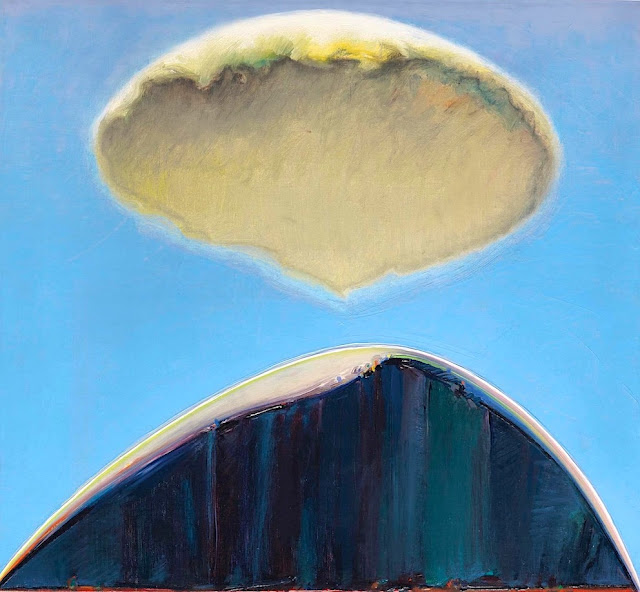
EL CAPITAN PAINTED BY WAYNE THIEBAUD


WAYNE THIEBAUD (1920-2021),El Capitan (2,309m - 7,573 ft), United States of America, In" Mount and Cloud", 1972, oil on canvas 20 1/4 x 22 in

WAYNE THIEBAUD (1920-2021)
El Capitan (2,309m - 7,573 ft)
United States of America

 In Mount and Cloud, 1972, oil on canvas 20 1/4 x 22 in.

 
The painter
Morton Wayne Thiebaud was an American painter known for his colorful works depicting commonplace objects—pies, lipsticks, paint cans, ice cream cones, pastries, and hot dogs—as well as for his landscapes and figure paintings. Thiebaud is associated with the pop art movement because of his interest in objects of mass culture, although his early works, executed during the fifties and sixties, predate the works of the classic pop artists. Thiebaud used heavy pigment and exaggerated colors to depict his subjects, and the well-defined shadows characteristic of advertisements are almost always included in his work.
Thiebaud was averse to labels such as "fine art" versus "commercial art" and described himself as "just an old-fashioned painter". He disliked Andy Warhol's "flat" and "mechanical" paintings and did not consider himself a pop artist.
In addition to pastries, Thiebaud painted characters such as Mickey Mouse as well as landscapes, streetscapes, and cityscapes, which were influenced by the work of Richard Diebenkorn. His paintings such as Sunset Streets (1985) and Flatland River (1997) are noted for their hyper realism, and have been compared to Edward Hopper's work, another artist who was fascinated with mundane scenes from everyday American life.
In 1962, Thiebaud's work was included, along with Roy Lichtenstein, Andy Warhol, Jim Dine, and Robert Dowd, in the historically important and ground-breaking "New Painting of Common Objects" curated at the Pasadena Art Museum.  This exhibition is considered to have been one of the first Pop Art exhibitions in the United States. These painters were part of a new movement, in a time of social unrest, which shocked the U.S. and the art world.

The mountain
El Capitan (2,309m - 7,573 ft) is a vertical rock formation in Yosemite National Park, located on the north side of Yosemite Valley, near its western end. The granite monolith extends about 3,000 feet (900 m) from base to summit along its tallest face and is one of the world's favorite challenges for rock climbers.
The formation was named "El Capitan" by the Mariposa Battalion when it explored the valley in 1851. El Capitan ("the captain") was taken to be a loose Spanish translation of the local Native American name for the cliff, variously transcribed as "To-to-kon oo-lah" or "To-tock-ah-noo-lah".
It is unclear if the Native American name referred to a specific tribal chief or simply meant "the chief" or "rock chief". In modern times, the formation's name is often contracted to "El Cap", especially among rock climbers and BASE jumpers.
The top of El Capitan can be reached by hiking out of Yosemite Valley on the trail next to Yosemite Falls, then proceeding west. For climbers, the challenge is to climb up the sheer granite face. There are many named climbing routes, all of them arduous, including Iron Hawk and Sea of Dreams, for example.
The Nose was first climbed in 1958 by Warren Harding, Wayne Merry and George Whitmore in 47 days using "siege" tactics: climbing in an expedition style using fixed ropes along the length of the route, linking established camps along the way.
In September 1973, Beverly Johnson and Sibylle Hechtel were the first team of women to ascend El Capitan via the Triple Direct route.

_______________________________


2022 - Wandering Vertexes...
by Francis Rousseau
Thursday, April 2, 2020

HALF DOME PAINTED BY THOMAS HILL


 THOMAS HILL (1829-1908),
Half Dome (2, 695 m - 8,844 ft)
United States of America (California)

In Royal Arches And Half Dome, Yosemite National Park, Private collection

The mountain
Half Dome (2, 695 m - 8,844 ft) is a granite dome at the eastern end of Yosemite Valley in Yosemite National Park, California, part of the Sierra Nevada Range. It is a well-known rock formation in the park, named for its distinct shape; One side is a sheer face while the other three sides are smooth and round, making it appear like a dome cut in half. The granite crest rises more than 4,737 ft (1,444 m) above the valley floor. The impression from the valley floor that this is a round dome that has lost its northwest half is an illusion. From Washburn Point, Half Dome can be seen as a thin ridge of rock, an arête, that is oriented northeast-southwest, with its southeast side almost as steep as its northwest side except for the very top. Although the trend of this ridge, as well as that of Tenaya Canyon, is probably controlled by master joints, 80 percent of the northwest "half" of the original dome may well still be there. As late as the 1870s, Half Dome was described as "perfectly inaccessible" by Josiah Whitney of the California Geological Survey. The summit was finally conquered by George G. Anderson in October 1875, via a route constructed by drilling and placing iron eyebolts into the smooth granite.
Today, Half Dome may now be ascended in several different ways. Thousands of hikers reach the top each year by following an 8.5 mi (13.7 km) trail from the valley floor. After a rigorous 2 mi (3.2 km) approach, including several hundred feet of granite stairs, the final pitch up the peak's steep but somewhat rounded east face is ascended with the aid of a pair of post-mounted braided steel cables originally constructed close to the Anderson route in 1919.
Alternatively, over a dozen rock climbing routes lead from the valley up Half Dome's vertical northwest face. The first technical ascent was in 1957 via a route pioneered by Royal Robbins, Mike Sherrick, and Jerry Gallwas, today known as the Regular Northwest Face. Their five-day epic was the first Grade VI climb in the United States. Their route has now been free soloed several times in a few hours' time. Other technical routes ascend the south face and the west shoulder.

The painter
Thomas Hill was an American artist of the 19th century. He produced many fine paintings of the California landscape, in particular of the Yosemite Valley, as well as the White Mountains of New Hampshire. Hill’s work was often driven by a vision resulting from his experiences with nature. For Thomas Hill, Yosemite Valley and the White Mountains of New Hampshire were his sources of inspiration to begin painting and captured his direct response to nature.
Hill was loosely associated with the Hudson River School of painters. The Hudson River School celebrated nature with a sense of awe for its natural resources, which brought them a feeling of enthusiasm when thinking of the potential it held. Mainly the earlier members of the Hudson River School, around the 1850-60’s, displayed man as in unison with nature in their landscape paintings by often painting men on a very small scale compared to the vast landscape. Thomas Hill often brought this technique into his own paintings in for example in his painting, Yosemite Valley, 1889.
He made early trips to the White Mountains with his friend Benjamin Champney and painted White Mountain subjects throughout his career. An example of his White Mountain subjects is Mount Lafayette in his Mount Lafayette in Winter.
Hill acquired the technique of painting en plein air. These paintings in the field later served as the basis for larger finished works. In plein air means to “paint outdoors and directly from the landscape”,[ which Hill incorporated into many of his paintings. Hill’s landscape paintings demonstrate how he combined his powers of observation with powerful motifs in each painting.
Hill’s move to California in 1861 brought him new material for his paintings. He chose monumental vistas, like Yosemite. During his lifetime, Hill’s paintings were popular in California, costing as much as $10,000. Hill's best works are considered to be these monumental subjects, including Great Canyon of the Sierra, Yosemite, Vernal Falls and Yosemite Valley.

___________________________________________

2020 - Wandering Vertexes...
by Francis Rousseau


Tuesday, February 11, 2020

THE MINARETS BY PETER ESSICK


PETER ESSICK
The Minarets (3,740 m - 12,270 ft)
United States of America (California)

For National Geographic

The mountains
The Minarets (3,740 m - 12,270 ft) are a series of jagged peaks located in the Ritter Range, a sub-range of the Sierra Nevada Mountains in the state of California. They are easily viewed from Minaret Summit, which is accessible by auto. Collectively, they form an arête, and are a prominent feature in the Ansel Adams Wilderness which was known as the Minaret Wilderness until it was renamed in honor of Ansel Adams in 1984.The peaks were named in 1868 by the California Geographical Survey, which reported: "To the south of Mount Ritter are some grand pinnacles of granite, very lofty and apparently inaccessible, to which we gave the name of 'the Minarets.'" Seventeen of the Minarets have been given unofficial names, including Michael Minaret, Adams Minaret, Leonard Minaret, and Clyde Minaret. Clyde Minaret, named after Norman Clyde, is the tallest of the spires. The Southeast Face Route of Clyde Minaret is a technical rock climb featured in Fifty Classic Climbs of North America.

The photographer
Peter Essick is a photographer, author, speaker, instructor, and drone pilot who specializes in nature and environmental themes. Named one of the 40 most influential nature photographers in the world by Outdoor Photography MagazineUK, Essick has been influenced by many noted American landscape photographers from Carleton Watkins to Robert Adams. His goal is to make photographs that move beyond mere documentation to reveal in careful compositions the human impact of development as well as the enduring power of the land. Essick is the author of two books of his photographs, The Ansel Adams Wilderness, and Our Beautiful, Fragile World. He has had solo exhibitions of his work at the Booth Western Art Museum, Yoho National Park: A Canadian Gem, and at Lumière Gallery, Compositions in Nature.Essick has photographed stories for National Geographicon many environmental issues including climate change, high-tech trash, nuclear waste and freshwater. Other work has been published in international magazines. Essick's photographs are in public and private collections. He is represented by Lumière Gallery in Atlanta, Georgia and Cavan Images, New York, New York.
Currently, Essick is working on a book of his photographs about Fernbank Forest, an urban old-growth forest in Atlanta, and will be published by Fall Line Press in the October 2019.

_____________________________

2020 - Wandering Vertexes..
by Francis Rousseau


Monday, November 4, 2019

NORTH PALISADE PAINTED BY PAUL GRIMM


PAUL  GRIMM  (1891-1974)
North Palisade  (4,343 m - 14,248 ft)
United States Of America (California) 

In Palisade Glacier, oil on canvas,  1928

The mountain
North Palisade is the third highest mountain in the Sierra Nevada range of California. It is the highest peak of the Palisades group of peaks in the central part of the range. It sports a small glacier (the Palisade Glacier painted above in the 20's) and several highly prized rock climbing routes on its northeast side.
North Palisade has several named subsidiary peaks (nearby peaks which have less than 300 ft (91 m) of topographic prominence). These all lie on the main ridge crest, and are as follows:
- Polemonium Peak  (4,294 m -  14,080 ft). Prominence of 160 feet (49 m).  This lies between the "U-Notch" and "V-Notch" couloirs (popular snow/ice climbs), 0.15 mi (0.25 km) east-southeast of North Palisade. Named on the USGS topographic map. The peak is named for the Polemonium eximium skypilot (plant) found in the area.
- Starlight Peak (4,328 m - 14,200 ft). Prominence of 80 feet (24 m).  This is the northwest summit of North Palisade, less than 0.1 mi (0.15 km) from the main summit. Some climbing routes end atop this peak known for its famous "Milk Bottle", a 20 ft (6.1 m) pillar of rock with huge exposure (class 5.6).
- Thunderbolt Peak (4,268 m - 14,003 ft). Prominence of 203 feet (62 m). About 0.25 mi (0.4 km) northwest of North Palisade. Named on the USGS topographic map. The Sierra Club guidebook notes: "This was the last 14,000 foot (4,267 m) peak to be climbed in the Sierra. During a wild storm on the first ascent, a bolt of lightning left Jules Eichorn severely shaken; hence the name".

The painter
Paul Grimm was an artist born from German parents in South Africa. As a small child, he moved with his parents to the United States. He reportedly was seen as having artistic talent as a child and, as an adult, attended a university-level art school in New York. Between 1910 and 1920, he  went to South America for a few years before settling in southern California.
Grimm gained much of his fame by painting landscapes of southern California in the 1920s.
Many works depict alluvial fans and desert vegetation in the eastern half of Riverside County. The San Jacinto Mountains appear frequently in his work. Most of the works are oil on canvas. . A residence on Calle Palo Fierro in the Palm Springs Warm Sands Neighborhood was built for him in 1935. He had a studio on Palm Canyon Drive in Palm Springs from the 1950s until his death in 1974.

___________________________________________
2019 - Wandering Vertexes...
by Francis Rousseau

Sunday, November 3, 2019

EAGLE PEAK BY CHIURA OBATA


CHIURA OBATA (1885–1975)
Eagle Peak (2,372 m - 7,783ft) 
United States of America  

 In Eagle Peak Trail, 1930,  color woodcut on paper,  Smithsonian American Art Museum

The peak
Eagle Peak is the highest of the Three Brothers (Eagle Peak  the uppermost "brother"-,  Middle and Lower Brothers), a rock formation, above Yosemite Valley in California.
Eagle peak is an independent peak is located just east of El Capitan. John Muir considered the view from the summit to be "most comprehensive of all the views" available from the north wall.
Eagle Peak can be reached by following the Upper Yosemite Falls and Eagle Peak trails. The hike is 6.0 miles (9.7 km) one way with a climb of over 3,500 feet (1,100 m). The trailhead is at Camp 4 near Yosemite Village. It passes near Yosemite Falls and affords many views of the valley.
The peak can also be reached form the Tamarack Flat Campground located off the Tioga Pass Road. The hike, which follows the El Capitan trail most of the way, is 7.7 miles (12.4 km)  but the trailhead is at about 6,400 feet (2,000 m). Another route starts at Yosemite Creek Campground at an elevation of 7,200 feet (2,200 m). This trailhead is at the end of a very rough, single lane, 4-mile (6.4 km) road.

The artist 
Chiura Obata (小圃 千浦 ) was a well-known Japanese-American artist and popular art teacher. A self-described "roughneck", Obata went to the United States in 1903, at age 17. After initially working as an illustrator and commercial decorator, he had a successful career as a painter, following a 1927 summer spent in the Sierra Nevada, and was a faculty member in the Art Department at the University of California, Berkeley, from 1932 to 1954, interrupted by World War II, when he spent over a year in internment camps.
After his retirement, he continued to paint and to lead group tours to Japan to see gardens and art.
Posthumous exhibitions of Obata's works have been organized at the Oakland Museum, The Smithsonian Institution, and, in 2000, at the M. H. de Young Memorial Museum in San Francisco, a retrospective of 100 ink and brush paintings, large scrolls and color woodblock prints. In 2007 there was an exhibit in Yosemite National Park. The museum collection at Yosemite National Park contains several Obata prints of the park (see above). The Smithsonian American Art Museum organized an exhibition of Obata's Yosemite woodblock prints, which was shown at the American Art Museum in Washington, DC in early 2008 and then traveled to the Wichita Falls Museum, Wichita, TX (2008) and Federal Hall National Memorial, National Park Service, in New York, NY (2009).

___________________________________________
2019 - Wandering Vertexes...
by Francis Rousseau

Friday, October 11, 2019

EL CAPITAN PAINTED BY THOMAS HILL


THOMAS HILL  (1829-1908)
El Capitan (2,309m - 7,573 ft) 
United States of America

In El Capitan, oil on cnavas,  Oakland Museum of California

The mountain
El Capitan  (2,309m - 7,573 ft) is a vertical rock formation in Yosemite National Park, located on the north side of Yosemite Valley, near its western end. The granite monolith extends about 3,000 feet (900 m) from base to summit along its tallest face and is one of the world's favorite challenges for rock climbers.
The formation was named "El Capitan" by the Mariposa Battalion when it explored the valley in 1851. El Capitan ("the captain") was taken to be a loose Spanish translation of the local Native American name for the cliff, variously transcribed as "To-to-kon oo-lah" or "To-tock-ah-noo-lah".
It is unclear if the Native American name referred to a specific tribal chief or simply meant "the chief" or "rock chief". In modern times, the formation's name is often contracted to "El Cap", especially among rock climbers and BASE jumpers.
The top of El Capitan can be reached by hiking out of Yosemite Valley on the trail next to Yosemite Falls, then proceeding west. For climbers, the challenge is to climb up the sheer granite face. There are many named climbing routes, all of them arduous, including Iron Hawk and Sea of Dreams, for example.
The Nose was first climbed in 1958 by Warren Harding, Wayne Merry and George Whitmore in 47 days using "siege" tactics: climbing in an expedition style using fixed ropes along the length of the route, linking established camps along the way.
In September 1973, Beverly Johnson and Sibylle Hechtel were the first team of women to ascend El Capitan via the Triple Direct route.

The painter
Thomas Hill produced many fine paintings of the California landscape, in particular of the Yosemite Valley, as well as the White Mountains of New Hampshire. Hill’s work was often driven by a vision resulting from his experiences with nature.
Hill was loosely associated with the Hudson River School of painters. The Hudson River School celebrated nature with a sense of awe for its natural resources, which brought them a feeling of enthusiasm when thinking of the potential it held. Mainly the earlier members of the Hudson River School, around the 1850-60’s, displayed man as in unison with nature in their landscape paintings by often painting men on a very small scale compared to the vast landscape. Thomas Hill often brought this technique into his own paintings in for example in his painting, Yosemite Valley, 1889.
He made early trips to the White Mountains with his friend Benjamin Champney and painted White Mountain subjects throughout his career. An example of his White Mountain subjects is Mount Lafayette in his Mount Lafayette in Winter.
Hill acquired the technique of painting en plein air. These paintings in the field later served as the basis for larger finished works.
Hill’s move to California in 1861 brought him new material for his paintings. He chose monumental vistas, like Yosemite. During his lifetime, Hill’s paintings were popular in California, costing as much as $10,000. Hill's best works are considered to be these monumental subjects, including Great Canyon of the Sierra, Yosemite, Vernal Falls and Yosemite Valley.

_____________________________
2019 - Wandering Vertexes...
by Francis Rousseau

Thursday, April 25, 2019

HALF DOME PHOTOGRAPHED BY ANSEL ADAMS


ANSEL ADAMS (1902-1984)
Half Dome (2, 695 m - 8,844 ft)  

United States of America (California) 

In  Moon and Half Dome, Yosemite National Park, 1960 

The mountain
Half Dome (2, 695 m - 8,844 ft)   is a granite dome at the eastern end of Yosemite Valley in Yosemite National Park, California, part of the Sierra Nevada Range. It is a well-known rock formation in the park, named for its distinct shape; One side is a sheer face while the other three sides are smooth and round, making it appear like a dome cut in half. The granite crest rises more than 4,737 ft (1,444 m) above the valley floor. The impression from the valley floor that this is a round dome that has lost its northwest half is an illusion. From Washburn Point, Half Dome can be seen as a thin ridge of rock, an arête, that is oriented northeast-southwest, with its southeast side almost as steep as its northwest side except for the very top. Although the trend of this ridge, as well as that of Tenaya Canyon, is probably controlled by master joints, 80 percent of the northwest "half" of the original dome may well still be there. As late as the 1870s, Half Dome was described as "perfectly inaccessible" by Josiah Whitney of the California Geological Survey. The summit was finally conquered by George G. Anderson in October 1875, via a route constructed by drilling and placing iron eyebolts into the smooth granite.
Today, Half Dome may now be ascended in several different ways. Thousands of hikers reach the top each year by following an 8.5 mi (13.7 km) trail from the valley floor. After a rigorous 2 mi (3.2 km) approach, including several hundred feet of granite stairs, the final pitch up the peak's steep but somewhat rounded east face is ascended with the aid of a pair of post-mounted braided steel cables originally constructed close to the Anderson route in 1919.
Alternatively, over a dozen rock climbing routes lead from the valley up Half Dome's vertical northwest face. The first technical ascent was in 1957 via a route pioneered by Royal Robbins, Mike Sherrick, and Jerry Gallwas, today known as the Regular Northwest Face. Their five-day epic was the first Grade VI climb in the United States. Their route has now been free soloed several times in a few hours' time. Other technical routes ascend the south face and the west shoulder.

 The photographer
Ansel Easton Adams was an American photographer and environmentalist.
His black-and-white landscape photographs of the American West, especially Yosemite National Park, have been widely reproduced on calendars, posters, books, and the internet. Adams and Fred Archer developed the Zone System as a way to determine proper exposure and adjust the contrast of the final print. The resulting clarity and depth characterized his photographs. He primarily used large-format cameras because their high resolution helped ensure sharpness in his images. Adams founded the photography group known as Group f/64, along with fellow photographers Willard Van Dyke and Edward Weston and Imogen Cunningham.
In September 1941, Adams contracted with the Department of the Interior to make photographs of National Parks, Indian reservations, and other locations for use as mural-sized prints for decoration of the Department's new building. Part of his understanding with the Department was that he might also make photographs for his own use, using his own film and processing.
Full entry Wanderingvertexes

___________________________________________
2019 - Wandering Vertexes...
by Francis Rousseau 

Friday, March 22, 2019

SENTINEL DOME & JEFFREY PINE BY ANSEL ADAMS


ANSEL ADAMS (1902-1984) 
Sentinel Dome  (2,477m - 8,127ft)
United States of America (California)  

In Jeffrey Pine, Sentinel Dome, Yosemite National Park, 1940


The mountain  and the pine 
Sentinel Dome  (2,477m - 8,127ft) is a granite dome in Yosemite National Park, United States. It lies on the south wall of Yosemite Valley, 0.8 miles (1.3 km) southwest of Glacier Point and 1.4 miles (2.3 km) northeast of Profile Cliff.
Sentinel Dome is known for a Jeffrey Pine that grew from its peak (see photograph above). The pine was photographed as early as 1867 by Carleton Watkins, and was the subject of the well-known photograph above  by Ansel Adams. The pine died during the drought of 1976, but remained standing until August 2003.
The original Native American name of Sentinel Dome, in the Southern Sierra Miwok language, was "Sakkaduch". The Bunnell survey named it "South Dome", but the Whitney survey renamed it Sentinel Dome (from its likeness to a watch-tower). The view from the top offers a 360 degree view of Yosemite Valley and surroundings. One can see Half Dome,Yosemite Falls, El Capitan,  North Dome, Basket Dome, and much more. 
The trail to the base of Sentinel Dome is a relatively easy 1.1-mile (1.8 km) hike. The trailhead, the same as the Taft Point trailhead, is located 6 miles (9.7 km) from Bridalveil Creek on the Glacier Point road. Once at the base, hikers traverse the less imposing northeast granite slope to the summit.In winter, Sentinel Dome can be reached from Badger Pass by a 10-miles ski tour.

The photographer 
Ansel Easton Adams was an American photographer and environmentalist.
His black-and-white landscape photographs of the American West, especially Yosemite National Park, have been widely reproduced on calendars, posters, books, and the internet. Adams and Fred Archer developed the Zone System as a way to determine proper exposure and adjust the contrast of the final print. The resulting clarity and depth characterized his photographs. He primarily used large-format cameras because their high resolution helped ensure sharpness in his images. Adams founded the photography group known as Group f/64, along with fellow photographers Willard Van Dyke and Edward Weston and Imogen Cunningham.
In September 1941, Adams contracted with the Department of the Interior to make photographs of National Parks, Indian reservations, and other locations for use as mural-sized prints for decoration of the Department's new building. Part of his understanding with the Department was that he might also make photographs for his own use, using his own film and processing. Although Adams kept meticulous records of his travel and expenses, he was less disciplined about recording the dates of his images, and neglected to note the date of Moonrise, so it was not clear whether it belonged to Adams or to the U.S. Government. But the position of the moon allowed the image to eventually be dated from astronomical calculations, and it was determined that Moonrise was made on November 1, 1941, a day for which he had not billed the Department, so the image belonged to Adams. The same was not true for many of his other negatives, including The Tetons and the Snake River, which, having been made for the Mural Project, became the property of the U.S. Government.
When Edward Steichen formed his Naval Aviation Photographic Unit in early 1942, he wanted Adams to be a member, to build and direct a state-of-the-art darkroom and laboratory in Washington, D.C. In February 1942, Steichen asked Adams to join. Adams agreed, with two conditions: He wanted to be commissioned as an officer, and he also told Steichen he would not be available until July 1. Steichen, who wanted the team assembled as quickly as possible, passed Adams by, and had his other photographers ready to go by early April.
Adams was distressed by the Japanese American Internment that occurred after the Pearl Harbor attack. He requested permission to visit the Manzanar War Relocation Center in the Owens Valley, at the foot of Mount Williamson. The resulting photo-essay first appeared in a Museum of Modern Art exhibit, and later was published as Born Free and Equal: The Story of Loyal Japanese-Americans. He also contributed to the war effort by doing many photographic assignments for the military, including making prints of secret Japanese installations in the Aleutians. " It was met with some distressing resistance and was rejected by many as disloyal." Adams was the recipient of three Guggenheim fellowships during his career, the first in 1946 to photograph every National Park. This series of photographs produced memorable images of Old Faithful Geyser, Grand Teton (above), and Mount McKinley....
Full entry Wanderingvertexes

___________________________________________
2019 - Wandering Vertexes...
by Francis Rousseau 

Monday, March 11, 2019

EAGLE PEAK BY ABBY WILLIAMS HILL


ABBY WILLIAMS HILL (1861-1943)
Eagle Peak (2,372 m - 7,783ft) 
United States of America  

 In  Eagle Peak, Yosemite park, oil on canvas,  University of Puget Sound 

The peak
Eagle Peak is the highest of the Three Brothers (Eagle Peak  the uppermost "brother"-,  Middle and Lower Brothers), a rock formation, above Yosemite Valley in California.
Eagle peak is an independent peak is located just east of El Capitan. John Muir considered the view from the summit to be "most comprehensive of all the views" available from the north wall.
Eagle Peak can be reached by following the Upper Yosemite Falls and Eagle Peak trails. The hike is 6.0 miles (9.7 km) one way with a climb of over 3,500 feet (1,100 m). The trailhead is at Camp 4 near Yosemite Village. It passes near Yosemite Falls and affords many views of the valley.
The peak can also be reached form the Tamarack Flat Campground located off the Tioga Pass Road. The hike, which follows the El Capitan trail most of the way, is 7.7 miles (12.4 km)  but the trailhead is at about 6,400 feet (2,000 m). Another route starts at Yosemite Creek Campground at an elevation of 7,200 feet (2,200 m). This trailhead is at the end of a very rough, single lane, 4-mile (6.4 km) road.

The Painter 
Abby Williams Hill was an American plein-air painter most known for her landscapes of the American West. Hill also advocated for children's rights, attended the 1905 Congress of Mothers in Washington, D.C., and founded the Washington (state) Parent-Teacher Association.
In the early 1900s, the Great Northern Railway and the Northern Pacific Railway commissioned Hill to paint landscapes of the northwestern United States to promote tourism. The commission required that Hill produce 22 paintings in just 18 weeks, and that she produce them en plein air.  Accompanied by her four children, Abby Hill took prolonged camping trips for the purpose of painting scenery in places such as Yosemite National Park and Yellowstone National Park.  Her works were exhibited at the 1904 World's Fair in St. Louis and the 1905 Lewis & Clark Centennial Exposition in Portland. Over the course of her career, Hill achieved her goal of painting in every national park in the Western United States.
Her husband became incapacitated by psychotic depression in 1911, so the family moved to the small isolated community of Laguna Beach, California, for the benefit of the mild, sunny climate.
Abby Hill was one of several early-20th-century American artists who built studios in Laguna Beach and transformed it into an artist community. She became a founding member of the Laguna Beach Art Association.
Following the death of her husband in 1938, Abby Hill became bedridden. She died in Laguna Beach in 1943.
A permanent collection of her works and papers is held by the University of Puget Sound.

___________________________________________
2019 - Wandering Vertexes...
by Francis Rousseau 

Sunday, March 4, 2018

MOUNT BREWER BY ALBERT BIERSTADT


ALBERT BIERSTADT (1830-1902)
Mount Brewer  (4,138 m - 13,576 ft)
United States of America (California) 

 In Mount Brewer from King's River Canyon, 1872, oil on canvas, Private Collection Texas

The mountain 
Mount Brewer  (4,138 m - 13,576 ft) is on the Great Western Divide, a sub-range of the Sierra Nevada in California. It is located in Kings Canyon National Park. The peak was named for William Henry Brewer who worked on the first California Geological Survey and was the first Chair of Agriculture at Yale University's Sheffield Scientific School. He was chief of the field party that explored the central High Sierra in 1864.

The painter 
Albert Bierstadt was a German-born American painter.  In 1851, he began to paint in oils. He became part of the Hudson River School in New York, an informal group of like-minded painters who started painting along this scenic river. Their style was based on carefully detailed paintings with romantic, almost glowing lighting, sometimes called luminism. An important interpreter of the western landscape, Bierstadt, along with Thomas Moran, is also grouped with the Rocky Mountain School.
In 1858 he exhibited a large painting of a Swiss landscape at the National Academy of Design, which gained him positive critical reception and honorary membership in the Academy.  At this time Bierstadt began painting scenes in New England and upstate New York, including in the Hudson River valley. A group of artists known as the Hudson River School portrayed its majestic landscapes and craggy areas, as well as the light affected by the changing waters.
In 1859, Bierstadt traveled westward in the company of Frederick W. Lander, a land surveyor for the U.S. government, to see those landscapes.  He continued to visit the American West throughout his career.
During the American Civil War, Bierstadt paid for a substitute to serve in his place when he was drafted in 1863. He completed one Civil War painting Guerrilla Warfare, Civil War in 1862, based on his brief experiences with soldiers stationed at Camp Cameron in 1861.
Bierstadt's painting was based on a stereoscopic photograph taken by his brother Edward Bierstadt, who operated a photography studio at Langley's Tavern in Virginia. Bierstadt's painting received a positive review when it was exhibited at the Brooklyn Art Association at the Brooklyn Academy of Music in December 1861. Curator Eleanor Jones Harvey observes that Bierstadt's painting, created from photographs, "is quintessentially that of a voyeur, privy to the stories and unblemished by the violence and brutality of first-hand combat experience."
In 1860, he was elected a member of the National Academy; he received medals in Austria, Bavaria, Belgium, and Germany. In 1867 he traveled to London, where he exhibited two landscape paintings in a private reception with Queen Victoria. He traveled through Europe for two years, cultivating social and business contacts to sustain the market for his work overseas.
Despite his popular success, Bierstadt was criticized by some contemporaries for the romanticism evident in his choices of subject and his use of light was felt to be excessive. 
Bierstadt was a prolific artist, having completed over 500 paintings during his lifetime. Many of these are held by museums across the United States.

Saturday, March 3, 2018

TENAYA PEAK BY CHIURA OBATA


CHIURA OBATA  (1885–1975)
Tenaya Peak (3,141m - 10, 306ft) 
Unites States of America (California)  


In  Death’s Grave Pass and Tenaya Peak in the background, High Sierra, 1930, Color woodcut 

About this painting 
Obata did at least two paintings mentioning Death's Grave Pass which appears to be somewhere northeast of Pywiack Dome, northwest of DAFF Dome. It is on no map. We have used Obata's descriptions of paintings to locate other sites where he obviously painted from.

The mountain 
Tenaya Peak (3,141m - 10, 306ft)  is a mountain in the Yosemite high country, rising above Tenaya Lake. Tenaya Peak is named after Chief Tenaya, who met the Mariposa Battalion near the shores of the Tenaya lake. The Mariposa Battalion under Captain John Boling expelled Chief Tenaya and his people from what was to become Yosemite National Park.

The artist 
Chiura Obata (小圃 千浦 ) was a well-known Japanese-American artist and popular art teacher. A self-described "roughneck", Obata went to the United States in 1903, at age 17. After initially working as an illustrator and commercial decorator, he had a successful career as a painter, following a 1927 summer spent in the Sierra Nevada, and was a faculty member in the Art Department at the University of California, Berkeley, from 1932 to 1954, interrupted by World War II, when he spent over a year in internment camps.
After his retirement, he continued to paint and to lead group tours to Japan to see gardens and art.
Posthumous exhibitions of Obata's works have been organized at the Oakland Museum, The Smithsonian Institution, and, in 2000, at the M. H. de Young Memorial Museum in San Francisco, a retrospective of 100 ink and brush paintings, large scrolls and color woodblock prints. In 2007 there was an exhibit in Yosemite National Park. The museum collection at Yosemite National Park contains several Obata prints of the park (see above). The Smithsonian American Art Museum organized an exhibition of Obata's Yosemite woodblock prints, which was shown at the American Art Museum in Washington, DC in early 2008 and then traveled to the Wichita Falls Museum, Wichita, TX (2008) and Federal Hall National Memorial, National Park Service, in New York, NY (2009).

Wednesday, November 29, 2017

THE HALF DOME PAINTED BY ARTHUR P. COLEMAN


ARTHUR P. COLEMAN (1852-1939)
Half Dome (2, 695 m - 8,844 ft)  
United States of America (California) 

The mountain
Half Dome (2, 695 m - 8,844 ft)   is a granite dome at the eastern end of Yosemite Valley in Yosemite National Park, California, part of the Sierra Nevada Range. It is a well-known rock formation in the park, named for its distinct shape; One side is a sheer face while the other three sides are smooth and round, making it appear like a dome cut in half. The granite crest rises more than 4,737 ft (1,444 m) above the valley floor. The impression from the valley floor that this is a round dome that has lost its northwest half is an illusion. From Washburn Point, Half Dome can be seen as a thin ridge of rock, an arête, that is oriented northeast-southwest, with its southeast side almost as steep as its northwest side except for the very top. Although the trend of this ridge, as well as that of Tenaya Canyon, is probably controlled by master joints, 80 percent of the northwest "half" of the original dome may well still be there.
As late as the 1870s, Half Dome was described as "perfectly inaccessible" by Josiah Whitney of the California Geological Survey. The summit was finally conquered by George G. Anderson in October 1875, via a route constructed by drilling and placing iron eyebolts into the smooth granite.
Today, Half Dome may now be ascended in several different ways. Thousands of hikers reach the top each year by following an 8.5 mi (13.7 km) trail from the valley floor. After a rigorous 2 mi (3.2 km) approach, including several hundred feet of granite stairs, the final pitch up the peak's steep but somewhat rounded east face is ascended with the aid of a pair of post-mounted braided steel cables originally constructed close to the Anderson route in 1919.
Alternatively, over a dozen rock climbing routes lead from the valley up Half Dome's vertical northwest face. The first technical ascent was in 1957 via a route pioneered by Royal Robbins, Mike Sherrick, and Jerry Gallwas, today known as the Regular Northwest Face. Their five-day epic was the first Grade VI climb in the United States. Their route has now been free soloed several times in a few hours' time. Other technical routes ascend the south face and the west shoulder.

The artist 
Arthur Philemon Coleman was a Canadian a geologist, professor, minerals prospector, artist, Rockies explorer, backwoods canoeist, world traveller, scientist, popular lecturer, museum administrator, memoirist and...  one of Canada’s most beloved scientist. 
Arthur Coleman is a fine example of that rare bird, a polished amateur artist whose drawings and paintings stand comfortably beside those of many professionals. He was active during the time when sketching and painting was ceding to photography the task of recording the visible world. Although he was also a photographer, painting was, for him, both a poetic and a descriptive pursuit, a way of wrapping an artistic expression around a phenomenon he was interested in or moved by. Thus motivated, Coleman's paintings give much joy and command a good deal of respect. The more surprising, perhaps given that he used to introduced himself more as a geologist than a painter.
Coleman travelled throughout the United States for professional conferences as well as geological field work.  He visited many of the major American mountain ranges including: the American Cordillera Mountains (Washington, Oregon and California); the Sierra Nevada Mountains (California and Nevada); Yellowstone National Park (Wyoming, Montana and Idaho); and the Appalachian Mountains (eastern United States). Pleistocene glaciation had extended in Northern Europe as far south as Berlin and London and covered an area of two million square miles. Coleman also visited such countries as India, Australia, Brazil, Argentina, Scandinavia, Bolivia, New Zealand, South Africa and Uruguay. In his final years he made two expeditions to the Andes in Colombia, to mountains in Southern Mexico and to two mountains in Central America.  He achieved the first ascent of Castle Mountain in 1884, and in 1907, he was the first white man to attempt to climb Mount Robson. He made a total of eight exploratory trips to the Canadian Rockies, wholly four of them looking for the mythical giants of Hooker and Brown. 
From 1901 to 1922, he was a Professor of Geology at the University of Toronto and was Dean of the Faculty of Arts from 1919 to 1922. From 1931 to 1934, he was a geologist with the Department of Mines of the Government of Ontario. He was elected a Fellow of the Royal Society of Canada in 1900 and was its President in 1921. In 1929, he was appointed Honorary Vice-President of the Royal Canadian Geographical Society.
 "Mount Coleman" and "Coleman Glacier" in Banff National Park are named in his honor. 
 He was awarded the Penrose Medal in 1936.
He planned to climb "hi" mountain, "Mount Coleman"'in the Albertan Rockies, and had also prepared a trip to British Guiana, but death intervened.

Saturday, June 24, 2017

MOUNT TALLAC PAINTED BY THOMAS HILL


THOMAS HILL (1829-1908) 
Mount Tallac (2,968m - 9, 739ft) 
United States of America (California) 

In  Mount Tallac from Lake Tahoe, 1880, oil on canvas, San Fransisco De Young Museum

The mountain
Mount Tallac  (2,968m - 9, 739ft) is a mountain peak southwest of Lake Tahoe, in El Dorado County, California. The peak lies within the Desolation Wilderness in the Eldorado National Forest.
Mount Tallac is quite visible from State Routes 89 and 28, and U.S. Route 50.  It is probably the most recognizable of the Tahoe Area peaks. With its distinctive "cross" of snow rising directly above the southwest corner of Lake Tahoe, Mount Tallac commands attention. While neither the highest peak in the area nor the hardest to summit, Mount Tallac nonetheless serves up enough adventure to satisfy nearly everyone.  Compared to the giants of the southern Sierra Nevada, Mount Tallac is a mere child. Still, it stands over 3,500 feet above the surface of Lake Tahoe, and from the summit, one may take in panoramic views of that amazing lake, as well as the enchanting peaks of Desolation Wilderness area. .The views from the summit, as well as the mountain's proximity to highway 89 and its wide selection of terrain types, make Mount Tallac one of the top hiking and backcountry skiing destinations in California.
Geologically, Mount Tallac is situated roughly on the boundary between the granites of the Sierra Nevada batholith, and the earlier metamorphosed sedimentary rocks. The southern and eastern slopes, especially Cathedral Peak, are crumbly, clinky "metaseds", while the other parts of the mountain are a bit more solid, but not Sierran granite, quite like Mount Ritter.
Source:
- Summit post

The painter
Thomas Hill was an American artist of the 19th century. He produced many fine paintings of the California landscape, in particular of the Yosemite Valley, as well as the White Mountains of New Hampshire. Hill’s work was often driven by a vision resulting from his experiences with nature. For Thomas Hill, Yosemite Valley and the White Mountains of New Hampshire were his sources of inspiration to begin painting and captured his direct response to nature.
Hill was loosely associated with the Hudson River School of painters. The Hudson River School celebrated nature with a sense of awe for its natural resources, which brought them a feeling of enthusiasm when thinking of the potential it held. Mainly the earlier members of the Hudson River School, around the 1850-60’s, displayed man as in unison with nature in their landscape paintings by often painting men on a very small scale compared to the vast landscape. Thomas Hill often brought this technique into his own paintings in for example in his painting, Yosemite Valley, 1889.
He made early trips to the White Mountains with his friend Benjamin Champney and painted White Mountain subjects throughout his career. An example of his White Mountain subjects is Mount Lafayette in his Mount Lafayette in Winter.
Hill acquired the technique of painting en plein air. These paintings in the field later served as the basis for larger finished works.
In plein air means to “paint outdoors and directly from the landscape”,[ which Hill incorporated into many of his paintings. Hill’s landscape paintings demonstrate how he combined his powers of observation with powerful motifs in each painting.
Hill’s move to California in 1861 brought him new material for his paintings. He chose monumental vistas, like Yosemite. During his lifetime, Hill’s paintings were popular in California, costing as much as $10,000.  Hill's best works are considered to be these monumental subjects, including Great Canyon of the Sierra, Yosemite, Vernal Falls and Yosemite Valley.
Source: 
- Sullivan Goss An American Gallery 

Thursday, June 15, 2017

NORTH PALISADE PAINTED BY FRANZ BISHOFF


FRANZ BISHOFF (1864-1929) 
North Palisade (4,341 m - 14, 242 ft)
United States of America (California) 

In Palisade Glacier, 1925, oil on canvas, Courtesy The Irvine Museum  

The mountain 
North Palisade (4,341 m - 14, 242 ft) is the third highest mountain in the Sierra Nevada range of California. It is the highest peak of the Palisades group of peaks in the central part of the range. It supports a small glacier (the Palisade Glacier) and several highly prized rock climbing routes on its northeast side.
North Palisade has a collection of names from the 19th century. The Wheeler Survey referred to it as Northwest Palisade in 1878. The following year, Lil Winchell called it Dusy's Peak after local rancher Frank Dusy. In 1895, Bolton Brown advocated yet another name, after David Starr Jordan. U.S. Senator Dianne Feinstein, supported by U.S. Senator Barbara Boxer, has introduced legislation to rename the peak as Brower Palisade, in honor of environmentalist David Brower.
The North Palisade' first ascent was made on July 25, 1903 by James S. Hutchinson, Joseph Nisbet LeConte and James K. Moffitt.
North Palisade has several named subsidiary peaks. These all lie on the main ridge crest, and are as follows:
Starlight Peak (4,328 m -14,200 feet ). This is the northwest summit of North Palisade, less than 0.1 mi (0.15 km) from the main summit. Some climbing routes end atop this peak known for its famous "Milk Bottle", a 20 ft (6.1 m) pillar of rock with huge exposure (class 5.6).
- Polemonium Peak (4,294+ m - 14,080+ ft) This lies between the "U-Notch" and "V-Notch" couloirs, 0.15 mi (0.25 km) east-southeast of North Palisade. Named on the USGS topographic map. The peak is named for the Polemonium eximium skypilot (plant) found in the area.
Thunderbolt Peak (4,268 m- 14,003 feet ).  About 0.25 mi (0.4 km) northwest of North Palisade. Named on the USGS topographic map. The Sierra Club guidebook notes: "This was the last 14,000 foot (4,267 m) peak to be climbed in the Sierra. During a wild storm on the first ascent, a bolt of lightning left Jules Eichorn severely shaken; hence the name".
The Palisade Glacier is located on the northeast side of the Palisades within the John Muir Wilderness in the central Sierra Nevada of California.  The glacier descends from the flanks of four mountain peaks over 4,300 m (14,000 ft)  in elevation of which North Palisade is third highest peak in the Sierra Nevada Range. The cirque containing the Palisade Glacier has a history of thousands of years of glaciation. The modern glacier attained its last maximum extent during the Little Ice Age, between 250 and 170 years ago (a period also known as the Matthes glaciation in the Sierra Nevada).
 It currently has an area of .31 sq mi (0.80 km2) and the glacier is .81 mi (1.30 km) long and .50 mi (0.80 km) wide. It is located between 13,400 and 12,000 ft (4,100 and 3,700 m) and moves at a rate of 20 ft (6.1 m) per year, although it is also retreating. 
Source: 

The painter 
 Franz Albert Bischoff  was an American artist known primarily for his China painting, floral paintings and California landscapes. He was born in Steinschцnau, Austria (now in Czech Republic).He immigrated to the United States as a teenager where he became a naturalized citizen. While in Europe, his early training was focused upon applied design, watercolor and ceramic decorations. After arriving in the United States, Bischoff worked in New York, Fostoria, Ohio, Detroit, Michigan and Dearborn, Michigan. While in Detroit and Dearborn, he gained success as a porcelain painter, and as a teacher of the techniques, as well as a manufacturer of ceramic glazes as well as a teacher of watercolor painting.
Franz Bischoff decided to visit California in 1900 and ultimately chose to settle in the Los Angeles area in 1906. Shortly after arriving, he started making arrangements to design and build a large Italian Renaissance style home in Pasadena that also became his studio. This landmark home was completed in 1908. Bischoff was one of the earliest members of the California Art Club, and the group's second meeting was held at his studio on February 5, 1910. Also present at that meeting were Carl Oscar Borg and William Wendt.
Inspired by the California countryside, Bischoff attempted to capture the area's brilliant light and diverse landscapes. Spending less time with ceramic painting following the start of World War I, Bischoff took up canvas painting. He painted local farms, fishing wharfs, coastal landscapes and scenes of the Sierra Nevada and the mountains of Utah, including Zion National Park.  Recognized during his career for use of color and vivid composition, his paintings always displayed reverence for nature. One critic commented that some of his later works flirted with Expressionism and his use of colors were reminiscent of Fauvism. Franz Bischoff died of heart failure at home in his adopted city of South Pasadena, California on February 5, 1929.
Source: 

Tuesday, May 9, 2017

MOUNT LYELL PAINTED BY EDGAR PAYNE


EDGAR PAYNE (1883-1947)
Mount Lyell (3, 999m - 13, 120ft) 
 United States of America (California)

In Sierra Nevada, Oil on canvas, Private collection  

The mountain
Mount Lyell  (3, 999m - 13, 120ft) is the highest point in Yosemite National Park. It is located at the southeast end of the Cathedral Range, 1.2 miles (1.9 km) northwest of Rodgers Peak. The peak as well as nearby Lyell Canyon is named after Charles Lyell, a well-known 19th century geologist. The peak had one of the last remaining glaciers in Yosemite, Lyell Glacier. The Lyell Glacier is currently considered to be a permanent ice field, not a living glacier. Mount Lyell divides the Tuolumne River watershed to the north, the Merced to the west, and the Rush Creek drainage in the Mono Lake Basin to the southeast.
The closest and most popular trailhead is at Tuolumne Meadows, off US120. Just east of the Tuolumne Meadows campground, there is a turnoff for the Tuolumne Lodge and Wilderness Permits. Pass the large lot for Wilderness permits (unless you need to get one!), and drive past the Ranger Station on the left side of the road. Before you reach the Tuolumne Lodge, there is a large parking lot on the left side. There are bear boxes there that you can leave food items that you do not take with you. Use them! Bears are rampant in these parts and will happily destroy your car to get a meal.
The trailhead is on the south side of the road, opposite the parking lot.
Alternatively, you can approach Mt. Lyell from the east via Rush Creek at Silver Lake Resort (near June Mtn Ski area) or Agnews Meadow near Mammoth Lakes (this is the longer of the two). Take the JMT to Donohue Pass to reach the Lyell Fork drainage. From a map it may be enticing to try approaching from the east via Marie Lakes instead of Donohue Pass, but be warned this is a class 4 route, and will certainly take longer. These routes are longer than approaching from Tuolumne Meadows and require more elevation gain. 
Climbing is usually done May-Oct when the Tioga Road (US120) through Tuolumne Meadows is open. After Oct 15 the road is sometimes open, but overnight parking is no longer permitted.

The painter 
Edgar Alwin Payne was an American Western landscape painter and muralist. He made his way to California for the first time in 1909, at the age of 26. He spent several months painting at Laguna Beach, then headed to San Francisco. In San Francisco he met other artists, including commercial artist Elsie Palmer (1884–1971). On  November 1912, Edgar married Elsie  Palmer.  As a couple they became well known in Chicago's art circle. Between 1915 and 1918-19, Edgar maintained a professional address in Chicago at the Tree Studio Building on East Ohio Street.
He earned his first major commission in 1917. In a bid to attract tourism, the Atchison, Topeka and Santa Fe Railroad asked him to paint the Southwest, along the railroads' trek from Albuquerque to California. This commission not only solidified his reputation as an artist, it also forever linked him to Western America. Although he painted in Europe, he is most remembered for his work from the Four Corners area of the Navajo Nation Reservation, Yosemite, and the California coast. This area, from Taos, New Mexico to the Grand Canyon, became one of Payne's two main inspirations for the next twenty years.
The Santa Fe Railroad commissions were the turn of the century brainchild of William H. Simpson, chief of the railway's advertising department. Starting in 1892, with Thomas Moran, Simpson exchanged travel on the train, along with lodging at railroad hotels and meals at railroad restaurants, and sometimes even cash, for paintings, photographs, pottery, and jewelry. This endeavor lasted for decades and made the Santa Fe one of the largest collectors of southwestern fine art.
His lifelong obsession with the Sierras would lead him to produce a documentary film, “Sierra Journey”. In 1941 he wrote "Composition of Outdoor Painting", a comprehensive book on composition and composition forms. The book also explains landscape painting techniques, color, repetition, rhythm, and value. The seventh edition printing of the work was completed in 2005.


Thursday, December 8, 2016

PICO BOLIVAR PHOTO COMPARISON BETWEEN 1950 AND 2011


PHOTO COMPARISON BETWEEN 1950 AND 2011  
Pico Bolívar (4,978 m - 16,332 ft) 
Venezuela

It is forecast that by 2020,  Venezuela will lose all its glaciers,

The mountain 
Pico Bolivar  (4,978 m -16,332 ft) is the highest mountain in Venezuela. Located in Mérida State, its top is permanently covered with névé snow and three small glaciers. It can be reached only by walking; the Mérida cable car, the highest cable car in the world, only reaches Pico Espejo. From there it is possible to climb to Pico Bolivar. The peak is named after the Venezuelan independence hero Simon Bolivar. The Pico Bolнvar is located on the mountain previously called La Columna, next to El Leуn (4,743 m) and El Toro (4,695 m). The new name was suggested by Tulio Febres Cordero in 1925. It was officially renamed on December 30, 1934. 
The height of this prominent Andean peak has been estimated and calculated various times during history. In 1912 one triangular measurement pointed at 5,002 metres. In 1928 came another calcutation at 5,007 metres, which stood as official height for a long time. During the 1990s the scientists Saler and Abad estimated the height, based upon GPS observations to be 4,980.8 metres.  However, no validation was made. New GPS measurements were made in 2002, which stated a height of 4,978.4 ±0.4 metres. These more correct findings were published in 2005.
The final measurement was made by José Napoleon Hernández from IGVSB; Diego Deiros and Carlos Rodriguez from USB and two guides from Inparques. GPS measurements designed for geodetic network consists of the vertices Pico Bolívar, El Toro, Piedras Blancas, and Mucuñuque Observatory, the latter belonging to the Venezuelan Red Geocentric REGVEN. Measurements were temporally equally long and continuous to ensure a greater volume of data over time to make more consistent and reliable information, five  GPS dual frequency receivers were used.
It is estimated that in 1910 the area covered by glaciers was around 10  km2, divided in two large areas, one embracing Picos Bolívar, Espejo and Concha and the other embracing Picos Humboldt and Bonpland. Possibly a small glaciated area covered the northwest side of Pico El Toro.
Aerial pictures taken in 1952 show the glaciated area had already shrunk to 0.9  km2 for the Picos Bolívar, Espejo and Concha and to 2.0  km2 for the Picos Humboldt and Bonpland.
In 2003 almost all the glaciers of the area had disappeared, with the exception of a two small glaciated areas (7.48 Ha on Pico Bolívar and 35.81 Ha on Pico Humboldt). 
It is forecast that at the current rate Venezuela will lose by 2020 all its glaciers, making it the first Andean country without any glaciated area.
First ascent was made by 1935 by Enrique Bourgoin, H. Márquez Molina and Domingo Peña.

Thursday, September 29, 2016

EL CAPITAN PAINTED BY JULES TAVERNIER


JULES TAVERNIER (1844-1889) 
El Capitan (2,309m - 7,573 ft) 
United States of America 

The mountain 
El Capitan is a vertical rock formation in Yosemite National Park, located on the north side of Yosemite Valley, near its western end. The granite monolith extends about 3,000 feet (900 m) from base to summit along its tallest face and is one of the world's favorite challenges for rock climbers.
The formation was named "El Capitan" by the Mariposa Battalion when it explored the valley in 1851. El Capitan ("the captain", "the chief") was taken to be a loose Spanish translation of the local Native American name for the cliff, variously transcribed as "To-to-kon oo-lah" or "To-tock-ah-noo-lah". It is unclear if the Native American name referred to a specific tribal chief or simply meant "the chief" or "rock chief".  In modern times, the formation's name is often contracted to "El Cap", especially among rock climbers and BASE jumpers.
The top of El Capitan can be reached by hiking out of Yosemite Valley on the trail next to Yosemite Falls, then proceeding west. For climbers, the challenge is to climb up the sheer granite face. There are many named climbing routes, all of them arduous, including Iron Hawk and Sea of Dreams, for example.
Climbing
The Nose was first climbed in 1958 by Warren Harding, Wayne Merry and George Whitmore in 47 days using "siege" tactics: climbing in an expedition style using fixed ropes along the length of the route, linking established camps along the way. 
The second ascent of The Nose was in 1960 by Royal Robbins, Joe Fitschen, Chuck Pratt and Tom Frost, who took seven days in the first continuous climb of the route without siege tactics. 
The first solo climb of The Nose was done by Tom Bauman in 1969. 
The first ascent of The Nose in one day was accomplished in 1975 by John Long, Jim Bridwell and Billy Westbay. Today, The Nose typically takes fit climbers 4–5 days of full climbing, and has a success rate of around 60%.
Beverly Johnson was the first woman to successfully ascend El Capitan, via the Nose route, with Dan Asay in June 1973. In September 1973, Beverly Johnson and Sibylle Hechtel were the first team of women to ascend El Capitan via the Triple Direct route, which takes the first ten pitches of the Salathe Wall, then continues up the middle portion of El Capitan via the Muir Wall, and finishes on the upper pitches of the Nose route.  In 1977, Molly Higgins and Barb Eastman climbed the Nose, to become the second party of women to climb El Capitan and the first to climb it via the Nose. In 1978, Bev Johnson was the first woman to solo El Capitan by climbing the Dihedral Wall.  Hazel Findlay has made three free ascents of El Capitan, including the first female ascent of Golden Gate in 2011, the first female ascent of Pre-Muir Wall in 2012, and a three-day ascent of Freerider in 2013.
Reference:
The painter 
Jules Tavernier was a French painter, illustrator, and an important member of Hawaii’s Volcano School.  He studied with the French painter, Félix Joseph Barrias (1822–1907). he left France in the 1870s and never  return. Tavernier was employed as an illustrator by Harper's Magazine, which sent him, along with Paul Frenzeny, on a year-long coast-to-coast sketching tour in 1873.
 Eventually, he continued westward to Hawaii, where he became quite famous as a landscape painter. He was fascinated by Hawaii’s erupting volcanoes—a subject that pre-occupied him for the rest of his life, which was spent in Hawaii, Canada and the western United States. Tavernier died on 18 May 1889 in Honolulu, Hawaii. He painted several version of the Kilauea erupting between 1880 and the end of his life.
Among the public collections holding paintings by Jules Tavernier are the Brigham Young University Museum of Art (Provo, UT), the Colorado Springs Fine Arts Center (Colorado Springs, CO), the Crocker Art Museum (Sacramento), the Gilcrease Museum (Tulsa, OK), Hearst Art Gallery (Saint Mary's College of California, Moraga, CA), the Honolulu Museum of Art, the Museum of Nebraska Art (Kearney, NE), the Oakland Museum of California, the San Diego Museum of Art, the Stark Museum of Art (Orange, TX), the Society of California Pioneers (San Francisco, CA), the Washington County Museum of Fine Arts (Hagerstown, MD) and the Yosemite Museum (Yosemite National Park).
After his death his art lived on in the hearts and homes of Hawaiians, and many more artists picked up on the volcano landscape theme he started. His Western art was mostly forgotten.
Fifty years after his death the Honolulu Advertiser remembered Jules Tavernier in December 1940 with the comment: “...to the generation which knew King Kalakaua, Tavernier recalls to mind some of the greatest paintings ever made of Hawaii volcanoes.”
At the beginning of the twenty-first century interest has reawakened in Tavernier's Western landscape art; museums are purchasing his pictures and prices for his oil paintings are increasing.
His students included D. Howard Hitchcock (1861–1943), Amédée Joullin (1862–1917), Charles Rollo Peters (1862–1917) and Manuel Valencia (1856–1935).
Reference