google.com, pub-0288379932320714, DIRECT, f08c47fec0942fa0 GRAVIR LES MONTAGNES... EN PEINTURE: Search results for Mount everest
Showing posts sorted by date for query Mount everest. Sort by relevance Show all posts

Sunday, April 2, 2023

MONT DENALI PEINT PAR JORGE RODRIGUEZ-GERADA


JORGE RODRIGUEZ-GERADA (bn.1 966)  Mount Denali (6, 190 m - 20, 310 ft) United States of America (Alaska)

JORGE RODRIGUEZ-GERADA (bn.1 966)
 Mount Denali (6, 190 m - 20, 310 ft)
United States of America (Alaska)


 La montagne
Denali (également connu sous le nom de mont McKinley,)) est le plus haut sommet de montagne en Amérique du Nord, avec une altitude au sommet de 6 190 m - 20 310 pieds au-dessus du niveau de la mer. Denali est le troisième sommet le plus important et le troisième le plus isolé après le mont Everest et l'Aconcagua. Denali est l'un des sept sommets, qui comprend les plus hautes montagnes de chacun des sept continents. Les atteindre tous est considéré comme un défi d'alpinisme, réalisé pour la première fois le 30 avril 1985 par Richard Bass.
Situé dans la chaîne de l'Alaska à l'intérieur de l'État américain de l'Alaska, Denali est la pièce maîtresse du parc national et de la réserve de Denali.
Denali a deux sommets importants: le sommet sud est le plus élevé, alors que le sommet nord a une altitude de 19 470 pieds (5 934 m). Le sommet nord est parfois compté comme un pic distinct et parfois non; il est rarement escaladé, sauf par ceux qui font des voies sur le versant nord du massif.
Cinq grands glaciers coulent des pentes de la montagne. Le glacier Peters se trouve sur le côté nord-ouest du massif, tandis que le glacier Muldrow tombe de ses pentes nord-est. Juste à l'est du Muldrow, et jouxtant le côté est du massif, se trouve le glacier Traleika. Le glacier Ruth se trouve au sud-est de la montagne et le glacier Kahiltna mène au côté sud-ouest de la montagne. Avec une longueur de 44 mi (71 km), le glacier Kahiltna est le plus long glacier de la chaîne de l'Alaska.
Les Koyukon Athabaskans qui habitent la région autour de la montagne ont pendant des siècles appelé le pic Dinale ou Denali. Il a été brièvement appelé Densmore's Mountain à la fin des années 1880 et au début des années 1890 en l'honneur de Frank Densmore, un prospecteur de l'Alaska qui fut le premier Européen à atteindre la base de la montagne.
En 1896, un chercheur d'or l'a nommé McKinley  en soutien au candidat à la présidence de l'époque, William McKinley, t devenu président l'année suivante. Les États-Unis ont officiellement reconnu le nom de Mount McKinley après que le président Wilson a signé le Mount McKinley National Park Act du 26 février 1917.
En 1965, Lyndon B. Johnson a déclaré les sommets nord et sud de la montagne les "Churchill Peaks", en l'honneur de l'homme d'État britannique Winston Churchill. Le Conseil des noms géographiques de l'Alaska a changé le nom de la montagne en Denali en 1975, comme on l'appelle localement.
Le 30 août 2015, juste avant une visite présidentielle en Alaska, l'administration de Barack Obama a annoncé que le nom Denali serait rétabli conformément à la désignation de l'Alaska Geographic Board.


L'artiste
Jorge Rodríguez-Gerada est un artiste contemporain cubano-américain. Né à Cuba le 5 février 1966 et élevé aux États-Unis. Il crée principalement des œuvres dans des espaces urbains à grande échelle. Il a été membre fondateur du mouvement de brouillage culturel new-yorkais du début des années 1990, travaillant d'abord avec le groupe "Artfux" et plus tard avec le "Cicada Corps of Artists". Au cours de cette période, il a également lancé des interventions sur les panneaux d'affichage et la publicité publique. En 1997, il a commencé à s'orienter vers le travail en solo. En 2002, Rodríguez-Gerada a déménagé à Barcelone où il s'est concentré sur les dessins au fusain éphémères à grande échelle, qui composent sa série Identity. Il a ensuite développé la Série Terrestre ; des terrassements éphémères si vastes qu'ils sont visibles de l'espace. D'autres projets en cours incluent la série Identity Composite et des œuvres d'art plus petites qu'il appelle Fragment Series, Urban Analogies et Memorylythics. Depuis 2009, il organise le festival annuel AvantGuard Urbano ; un petit festival d'art urbain avec de grands noms, qui s'est tenu à Tudela, en Navarre, dans le nord de l'Espagne. Il participe également à de nombreux salons et expositions.

 __________________________________________

2023 - Wandering Vertexes ....
Errant au-dessus des Sommets Silencieux...
Un blog de Francis Rousseau 


Thursday, September 29, 2022

THE MONT BLANC PAINTED BY CESARE MAGGI

CESARE MAGGI (1881-1962) The Mont Blanc (4,808.73 m -15,777 ft) France - Italy   in "The Mont Blanc seen from italy", oil on canvas, 100 x 140 cm


CESARE MAGGI (1881-1962)
The Mont Blanc (4,808.73 m -15,777 ft)
France - Italy 

in "The Mont Blanc seen from italy", oil on canvas, 100 x 140 cm

 
The painter
The italian painter Cesare Maggi was born into a family of actors, Maggi embarked on classical studies at his father’s wish but also took up painting at a very early age His debut in Florence at the Esposizione Annuale della Società di Belle Arti di Firenze in 1898 was followed by a short trip to Paris to catch up with the latest developments.
The crucial turning point in Maggi’s art came in 1889 with the posthumous show of work by Giovanni Segantini held by the Milanese Society of Fine Arts, which prompted a definitive shift to landscape painting of a Divisionist character. After a short stay in the Engadin, he returned to Milan before finally settling in Turin. Commercial collaboration with Alberto Grubicy until 1913 enabled Maggi to establish himself quickly as one of the leading representatives of the second generation of Divisionist painters in Italy. He painted a repertoire of readily comprehensible mountain landscapes focusing primarily on aspects of the visual perception of the reflection of light and colour but lacking the deep spirituality of Segantini’s work. He took part in the major Italian and European exhibitions and the Venice Biennale devoted an entire room to his work at the Esposizione Internazionale d’Arte of Venice in 1912. After an interlude devoted to portrait painting in the same decade, the artist’s mature work focused on greater simplification of subject matter, mostly in landscapes.
Maggi obtained the chair in painting at the Albertina Academy, Turin, in 1936.


The mountain
The Mont-Blanc (in French) (4 ,808.73 m -15,777 ft) or Monte Bianco (in Italian), both meaning "White Mountain", is the highest mountain in the Alps and the highest in Europe after the Caucasus peaks. It is ranked 11th in the world in topographic prominence. The Mont Blanc is one of the Seven Summit, which includes the highest mountains of each of the seven continents. Summiting all of them is regarded as a mountaineering challenge, first achieved on April 30, 1985 by Richard Bass. The 7 highest summit, (which are obviously 8 with 2 in Europe !) are : Mount Everest (8,848m), Aconcagua (6,961m), Mt Denali or Mc Kinley (6,194m), Kilimandjaro (5,895m), Mt Elbrus (5,642m), Mount Vinson (4,892m) and Mount Kosciuszko (2,228m) in Australia.
The overcrowding threshold of Mont Blanc is reached, with 300 to 400 departures per day in summer.
At the summit of the National Mountain Council held in Sallanches at the end of August 2006, it was estimated that between 25,000 and 30,000 people set out in 2005 to conquer Mont Blanc. With the opening of new markets (Russia, China, India), 50,000 to 100,000 people could tomorrow try the adventure, the figure of 200,000 has even been advanced.
These prospects are nightmarish for the defenders of the site and for some political leaders of the valley, such as the mayor of Saint-Gervais-les-Bains, common on which Mont Blanc is located.

 - More about the Mont-Blanc


___________________________________________
2022 - Wandering Vertexes...
by Francis Rousseau

Friday, August 19, 2022

THE K2 PEAK PHOTOGRAPHED BY VITTORIO SELLA IN 1909


VITTORIO SELLA (1859-1843)    The K2  peak (8,611m - 28,251 ft)  China - Pakistan border  Photographed during the 1909 expedition  led by Prince Luigi Amedeo, Duke of the Abruzzi

VITTORIO SELLA (1859-1843)  
 The K2  peak (8,611m - 28,251 ft) 
China - Pakistan border

Photographed during the 1909 expedition 
led by Prince Luigi Amedeo, Duke of the Abruzzi 

The artist
Vittorio Sella is a mountain italian climber and photographer who took his passion for mountains from his uncle, Quintino Sella, founder of the Italian Alpine Club.  He accomplished many remarkable climbs in the Alps, the first wintering in the Matterhorn and Mount Rose (1882) and the first winter crossing of Mont Blanc (1888).
He took part in various expeditions outside Italy:
- Three in the Caucasus in 1889, 1890 and 1896 where a summit still bears his name;
- The ascent of Mount Saint Elias in Alaska in 1897;
- Sikkim and Nepal in 1899;
- Possibly climb Mount Stanley in Uganda in 1906 during an expedition to the Rwenzori;
- Recognition at K2  in 1909 (aAbove)
- In Morocco in 1925.
During expeditions in Alaska, Uganda and Karakoram (K2), he accompanied the Duke of Abruzzi, Prince Luigi Amedeo di Savoia.
Sella continues the practice of climbing into his old age, completing his final attempt in the Matterhorn at the age of 76; a climb he had to interrupt the rise following an accident in which one of his guides injured. He died in his hometown during World War II.  His photographic collection is now managed by the Sella Foundation.
His photos mountain are still  considered today to be among the finest ever made.
Jim Curran believes that "Sella remains probably the greatest photographer of the mountain.  His name is synonymous with technical perfection and aesthetic refinement. "
The quality of the pictures of Vittorio Sella is partly explained by the use of a view camera 30 × 40 cm, despite the difficulty of the transportation of such a device, both heavy and fragile in places inaccessible; to be able to transport it safely, he had to make special pieces that can be stored in saddle bags.  His photographs have been widely distributed, either through the press or in the galleries, and were unanimously celebrated; Ansel Adams, who was able to admire thirty-one in an exhibition that was organized at Sella American Sierra Club, said they inspired him "a religious kind of sense of wonder."  Many of his pictures were taken in the mountains for the very first time in the History, which give them a much artistic, historical  but also scientific value ; for example, one could measure the decline in the Rwenzori glaciers in Central Africa.

The mountain 
K2 peak (8,611m - 28,251 ft)  also known as Mount Godwin-Austen or Chhogori is the second highest mountain in the world, after Mount Everest. It is located on the China-Pakistan border between Baltistan, in the Gilgit–Baltistan region of northern Pakistan, and the Taxkorgan Tajik Autonomous County of Xinjiang, China.
The name K2 is derived from the notation used by the Great Trigonometric Survey of British India. Thomas Montgomerie made the first survey of the Karakoram from Mount Haramukh, some 210 km (130 miles) to the south, and sketched the two most prominent peaks, labeling them K1 and K2.
The policy of the Great Trigonometric Survey was to use local names for mountains wherever possible and K1 was found to be known locally as Masherbrum. K2, however, appeared not to have acquired a local name, possibly due to its remoteness. The mountain is not visible from Askole, the last village to the south, or from the nearest habitation to the north, and is only fleetingly glimpsed from the end of the Baltoro Glacier, beyond which few local people would have ventured. The name Chogori, derived from two Balti words, chhogo ("big") and ri ("mountain")  has been suggested as a local name, but evidence for its widespread use is scant. It may have been a compound name invented by Western explorers or simply a bemused reply to the question "What's that called?" It does, however, form the basis for the name Qogir (simplified Chinese: 乔戈里峰; traditional Chinese: 喬戈里峰; pinyin: Qiбogēlǐ Fēng) by which Chinese authorities officially refer to the peak. Other local names have been suggested including Lamba Pahar ("Tall Mountain" in Urdu) and Dapsang, but are not widely used.
Lacking a local name, the name Mount Godwin-Austen was suggested, in honor of Henry Godwin-Austen, an early explorer of the area, and while the name was rejected by the Royal Geographical Society, it was used on several maps, and continues to be used occasionally.
The surveyor's mark, K2, therefore continues to be the name by which the mountain is commonly known. It is now also used in the Balti language, rendered as Kechu or Ketu (Urdu: کے ٹو‎). The Italian climber Fosco Maraini argued in his account of the ascent of Gasherbrum IV that while the name of K2 owes its origin to chance, its clipped, impersonal nature is highly appropriate for so remote and challenging a mountain. He concluded that it was ...
K2 is the highest point of the Karakoram range and the highest point in both Pakistan and Xinjiang.

Friday, June 3, 2022

NUPTSE PAINTED BY JAMES HART DYKE


JAMES HART DYKE  (bn 1966) Nuptse  (7,861 m - 25,791 ft) Nepal  In Nuptse Himalaya ,2011, Acrylic on paper-  Courtesy John Mitchell  Gallery, London


JAMES HART DYKE  (bn 1966)
Nuptse  (7,861 m - 25,791 ft)
Nepal

In Nuptse Himalaya ,2011, Acrylic on paper,  Courtesy John Mitchell  Gallery, London


The mountain
Nuptse or Nubtse is a mountain in the Khumbu region of the Mahalangur Himal, in the Nepalese Himalayas. It lies two kilometres WSW of Mount Everest. Nubtse is Tibetan for "west peak", as it is the western segment of the Lhotse-Nubtse massif.
The main peak, Nubtse I, was first climbed on May 16, 1961 by Dennis Davis and Sherpa Tashi and the following day by Chris Bonington, Les Brown, James Swallow and Pemba Sherpa, members of a British expedition led by Joe Walmsley. After a long hiatus, Nubtse again became the objective of high-standard mountaineers in the 1990s and 2000s, with important routes being put up on its west, south, and north faces. While Nubtse is a dramatic peak when viewed from the south or west, and it towers above the base camp for the standard south col route on Everest, it is not a particularly independent peak: its topographic prominence is only 319 m (1,047 ft). Hence it is not ranked on the list of highest mountains.


The painter
James Hart Dyke’s work is centred on landscape painting, from the domesticity of paintings of country houses to paintings generated from physically demanding expeditions over remote mountains. James has also undertaken a series of projects including accompanying HRH The Prince of Wales as the official artist on royal tours, working as ‘artist in residence’ for The British Secret Intelligence Service, working as an artist embedded with the British Forces in war zones, working for the producers of the James Bond films and working as ‘artist in residence’ for Aston Martin. These projects required him to respond in many different ways and have allowed him to experiment with more graphic forms of painting influenced by his studies as an architect at the Royal College of Art. His portraits have been shown at the National Portrait Gallery and at the Royal Society of Portrait Painters exhibitions.

___________________________
2022 - Wandering Vertexes
Un blog de Francis Rousseau

Thursday, May 19, 2022

CERRO ACONCAGUA PAINTED BY RHOD WULFARS


RHOD WULFARS (bn. 1979) Aconcagua (6,961 m -22,838 ft) Argentina  In "Aconcagua," Acrylic on canvas, 18 x 24cm

RHOD WULFARS (bn. 1979)
Aconcagua (6,961 m -22,838 ft)
Argentina

In "Aconcagua," Acrylic on canvas, 18 x 24cm


The artist
Rhod Wulfars is a contemporary mountain painter using mainly acrylic technique for his paintings.
He was born in 1979 in Mendoza (Argentina). In his website he wrote: "I have spent my whole life by the mountains. On day I started to paint them". Using, in the manner of Nicolas de Staël, a style always beetween abstract and figurative, his very strong and very moving paintings described perfectly the majesty and the spectacular contents of the peaks he paints. Rhod Wulfars makes a surprising use of acrylic medium, in thick paste as one could do with oil paint. He used to named his works only bu numbers, and series letters, but sometime he writes the name of the peaks ans makes it more easy to identify.
Other works by this artist on his website : rhodwulfars.wixsite.com/rhodwulfars/
Contact : @rhodwulfars


The mountain
Cerro Aconcagua (6,961 meters -22,838 ft) or simplynThe Aconcagua is the highest mountain outside of Asia and by extension the highest point in both the Western Hemisphere and the Southern Hemisphere.
Aconcagua is not a volcano.  he origin of the name is contested; it is either from the Mapuche "Aconca-Hue", which refers to the Aconcagua River, the Quechua "Ackon Cahuak", meaning "Sentinel of Stone", or Quechua "Anco Cahuac", meaning "White Sentinel" or the Aymara "Janq'u Q'awa" meaning "White Ravine", "White Brook".
Aconcagua is located in the Andes mountain range, in the Mendoza Province, Argentina, and lies 112 kilometers (70 mi) northwest of its capital, the city of Mendoza and 108 km (67 mi) from Santiago de Chile (the capital of Chile). The summit is in fact located about 5 kilometers from San Juan Province and 15 kilometers from the international border with Chile; its nearest higher neighbor is Tirich Mir in the Hindu Kush, 16,520 kilometers (10,270 mi) away.
Aconcagua is one of the Seven Summit, which includes the highest mountains of each of the seven continents. The 7 summits (which are obviously 8 !)... are : Mt Everest (8,848m), Mt Denali or Mc Kinley (6,194m), Kilimandjaro (5,895m), Mt Elbrus (5,642m), Vinson Massif (4,892m), Mt Blanc (4,807m) and Mount Kosciuszko (2,228m). Summiting all of them is regarded as a mountaineering challenge, first achieved on April 30, 1985 by Richard Bass.
The mountain and its surroundings are part of the Aconcagua Provincial Park. The mountain has a number of glaciers. The largest glacier is the Ventisquero Horcones Inferior at about 10 km long, which descends from the south face to about 3600 m altitude near the Confluencia camp. Two other large glacier systems are the Ventisquero de las Vacas Sur and Glaciar Este/Ventisquero Relinchos system at about 5 km. 

___________________________

2022 - Wandering Vertexes...
by Francis Rousseau


Saturday, May 7, 2022

MOUNT DAMAVAND / دماوند SKETCHED BY HUSAYN WA'IZ KASHIFI


HUSAYN VAIZ KASHIFI  i(died 1504-1505) Mount Damavand (5, 610m -18,410ft) Iran  In The Anvār-i Suhaylī or Lights of Canopus, 1847, The Walters Art Museum


HUSAYN WA'IZ KASHIFI (840 /1436 - 910/ 1505)
Mount Damavand   (6,105m-18,410ft)
Iran

In The Anvār-i Suhaylī or Lights of Canopus, The Walters Art Museum, Baltimore


About this work
Walters Art Museum manuscript W.599 is an illuminated and illustrated copy of Anvar-i Suhayli (The lights of Canopus), dating to the 13th century AH/AD 19thand attributed to Husayn  Kashifi
It is a Persian version of Kalilah wa-Dimnah (The fables of Bidpay). It was completed on 26 Jumadá I 1264 AH/AD 1847 by Mirza Rahim. The text is written in Nasta'liq script in black and red ink, revealing the influence of Shikastah script. There are 123 paintings illustrating the text. The Qajar binding is original to the manuscript.

The mountain
Mount Damāvand (5, 610m -18,410ft), in Persian دماوند‎‎ , a potentially active volcano, is a stratovolcano which is the highest peak in Iran and the Middle East as well as the highest volcano in Asia (the Kunlun Volcanic Group in Tibet has a higher elevation than Damāvand, but are not considered to be volcanic mountains). It has a special place in Persian mythology and folklore.The origins and meaning of the word "Damavand" is unclear, yet some prominent researchers have speculated that it probably means "The mountain from which smoke and ash arises", alluding to the volcanic nature of the mountain.
This peak is located in the middle of the Alborz range, adjacent to Varārū, Sesang, Gol-e Zard, and Mīānrūd. The mountain is located near the southern coast of the Caspian Sea, in Amol County, Mazandaran Province, 66 kilometres (41 miles) northeast of the city of Tehran. Mount Damāvand is the 12th most prominent peak in the world, and the second most prominent in Asia after Mount Everest. It is the highest volcanic mountain in Asia, and part of the Volcanic Seven Summits mountaineering challenge. Damavand is a significant mountain in Persian mythology. It is the symbol of Iranian resistance against despotism and foreign rule in Persian poetry and literature. In Zoroastrian texts and mythology, the three-headed dragon Aži Dahāka was chained within Mount Damāvand, there to remain until the end of the world. In a later version of the same legend, the tyrant Zahhāk was also chained in a cave somewhere in Mount Damāvand after being defeated by Kāveh and Fereydūn. Persian poet Ferdowsi depicts this event in his masterpiece, the Shahnameh, in which the mountain is said to hold magical powers. Damāvand has also been named in the Iranian legend of Arash (as recounted by Bal'ami) as the location from which the hero shot his magical arrow to mark the border of Iran, during the border dispute between Iran and Turan. The famous poem Damāvand by Mohammad Taqī Bahār is also one fine example of the mountain's significance in Persian literature.
Mount Damavand is depicted on the reverse of the Iranian 10,000 rials banknote.
An anthropologist of Mazandaran Cultural Heritage and Tourism Department, Touba Osanlou, has said that a proposal has been put forward by a group of Iranian mountaineers to register the highest peak in the Middle East, Mount Damavand as a national heritage site. Mazandaran Cultural Heritage and Tourism Department has accepted the proposal, the Persian daily Jam-e Jam reported.

The artist
Kamāl al-Dīn Ḥusayn ibn Alī Kashifi, best simply known as Husayn Kashifi, was a prolific Persia] prose-stylist, a poet, a Quran exegete, a Sufi scholar, and an astronomer of the Timurid era. Kashifi was his pen name, whereas his surname al-Wāʿiẓ ("the preacher") denoted his professional occupation. He spent most of his career in Herat, where his academic activities were supported by Ali-Shir Nava'i, a senior vizier in the Timurid court during Sultan Husayn Bayqara's rule, hence the reason for Kashifi to dedicate most of his works to Nava'i. He was also very close to the famous Persian poet and Sufi, Nur al-Din 'Abd al-Rahman Jami. His famous works include Akhlaq-e Mohseni and Anwar-e Sohaili  (above) in Persian prose, and Jawaher al-Tafsir and Mawaheb-e 'Aliyya which are Persian tafsirs of the Quran.

_______________________________________

2022 - Wandering Vertexes...
by Francis Rousseau


Saturday, April 23, 2022

THE MONT BLANC PAINTED BY CESARE MAGGI


CESARE MAGGI (1881-1962), The Mont Blanc (4,808.73 m -15,777 ft) France - Italy  In " Alla montagne, il Monte Biancho", fuile sur toile, détail.

CESARE MAGGI (1881-1962),
The Mont Blanc (4,808.73 m -15,777 ft)
France - Italy

In " Alla montagne, il Monte Biancho", oil on canvas 


The painter
The italian painter Cesare Maggi was born into a family of actors, Maggi embarked on classical studies at his father’s wish but also took up painting at a very early age His debut in Florence at the Esposizione Annuale della Società di Belle Arti di Firenze in 1898 was followed by a short trip to Paris to catch up with the latest developments.
The crucial turning point in Maggi’s art came in 1889 with the posthumous show of work by Giovanni Segantini held by the Milanese Society of Fine Arts, which prompted a definitive shift to landscape painting of a Divisionist character. After a short stay in the Engadin, he returned to Milan before finally settling in Turin. Commercial collaboration with Alberto Grubicy until 1913 enabled Maggi to establish himself quickly as one of the leading representatives of the second generation of Divisionist painters in Italy. He painted a repertoire of readily comprehensible mountain landscapes focusing primarily on aspects of the visual perception of the reflection of light and colour but lacking the deep spirituality of Segantini’s work. He took part in the major Italian and European exhibitions and the Venice Biennale devoted an entire room to his work at the Esposizione Internazionale d’Arte of Venice in 1912. After an interlude devoted to portrait painting in the same decade, the artist’s mature work focused on greater simplification of subject matter, mostly in landscapes.
Maggi obtained the chair in painting at the Albertina Academy, Turin, in 1936.


The mountain

The Mont-Blanc (in French) (4 ,808.73 m -15,777 ft) or Monte Bianco (in Italian), both meaning "White Mountain", is the highest mountain in the Alps and the highest in Europe after the Caucasus peaks. It is ranked 11th in the world in topographic prominence. The Mont Blanc is one of the Seven Summit, which includes the highest mountains of each of the seven continents. Summiting all of them is regarded as a mountaineering challenge, first achieved on April 30, 1985 by Richard Bass. The 7 highest summit, (which are obviously 8 with 2 in Europe !) are : Mount Everest (8,848m), Aconcagua (6,961m), Mt Denali or Mc Kinley (6,194m), Kilimandjaro (5,895m), Mt Elbrus (5,642m), Mount Vinson (4,892m) and Mount Kosciuszko (2,228m) in Australia.
The mountain lies in a range called the Graian Alps, between the regions of Aosta Valley, Italy, and Savoie and Haute-Savoie, France. The location of the summit is on the watershed line between the valleys of Ferret and Veny in Italy and the valleys of Montjoie, and Arve in France. The Mont Blanc massif is popular for mountaineering, hiking, skiing, and snowboarding.
The three towns and their communes which surround Mont Blanc are Courmayeur in Aosta Valley, Italy, and Saint-Gervais-les-Bains and Chamonix in Haute-Savoie, France. A cable car ascends and crosses the mountain range from Courmayeur to Chamonix, through the Col du Géant. Constructed beginning in 1957 and completed in 1965, the 11.6 km (7¼ mi) Mont Blanc Tunnel runs beneath the mountain between these two countries and is one of the major trans-Alpine transport routes.
Since the French Revolution, the issue of the ownership of the summit has been debated.
From 1416 to 1792, the entire mountain was within the Duchy of Savoy. In 1723 the Duke of Savoy, Victor Amadeus II, acquired the Kingdom of Sardinia. The resulting state of Sardinia was to become preeminent in the Italian unification.[ In September 1792, the French revolutionary Army of the Alps under Anne-Pierre de Montesquiou-Fézensac seized Savoy without much resistance and created a department of the Mont-Blanc. In a treaty of 15 May 1796, Victor Amadeus III of Sardinia was forced to cede Savoy and Nice to France. In article 4 of this treaty it says: "The border between the Sardinian kingdom and the departments of the French Republic will be established on a line determined by the most advanced points on the Piedmont side, of the summits, peaks of mountains and other locations subsequently mentioned, as well as the intermediary peaks, knowing: starting from the point where the borders of Faucigny, the Duchy of Aoust and the Valais, to the extremity of the glaciers or Monts-Maudits: first the peaks or plateaus of the Alps, to the rising edge of the Col-Mayor". This act further states that the border should be visible from the town of Chamonix and Courmayeur. However, neither the peak of the Mont Blanc is visible from Courmayeur nor the peak of the Mont Blanc de Courmayeur is visible from Chamonix because part of the mountains lower down obscure them. A Sardinian Atlas map of 1869 showing the summit lying two thirds in Italy and one third in France.
After the Napoleonic Wars, the Congress of Vienna restored the King of Sardinia in Savoy, Nice and Piedmont, his traditional territories, overruling the 1796 Treaty of Paris. Forty-five years later, after the Second Italian War of Independence, it was replaced by a new legal act. This act was signed in Turin on 24 March 1860 by Napoleon III and Victor Emmanuel II of Savoy, and deals with the annexation of Savoy (following the French neutrality for the plebiscites held in Tuscany and Emilia-Romagna to join the Kingdom of Sardinia, against the Pope's will). A demarcation agreement, signed on 7 March 1861, defines the new border. With the formation of Italy, for the first time Mont Blanc is located on the border of France and Italy.
The 1860 act and attached maps are still legally valid for both the French and Italian governments. One of the prints from the 1823 Sarde Atlas positions the border exactly on the summit edge of the mountain (and measures it to be 4,804 m (15,761 ft) high). The convention of 7 March 1861 recognises this through an attached map, taking into consideration the limits of the massif, and drawing the border on the icecap of Mont Blanc, making it both French and Italian.Watershed analysis of modern topographic mapping not only places the main summit on the border, but also suggests that the border should follow a line northwards from the main summit towards Mont Maudit, leaving the southeast ridge to Mont Blanc de Courmayeur wholly within Italy.
Although the Franco-Italian border was redefined in both 1947 and 1963, the commission made up of both Italians and French ignored the Mont Blanc issue. In the early 21st century, administration of the mountain is shared between the Italian town of Courmayeur and the French town of Saint-Gervais-les-Bains, although the larger part of the mountain lies within the commune of the latter.

___________________________________________
2022- Wandering Vertexes...
by Francis Rousseau

Tuesday, March 22, 2022

THE MER DE GLACE AND GRAND CHARMOZ PAINTED BY GABRIEL LOPPÉ


GABRIEL LOPPÉ (1825-1913), Les Aiguilles du Grand Charmoz (3,445m - 11,302ft) France  In La Mer de Glace et les Grands Charmoz, Chamonix, Huile sur toile, Courtesy JohnMitchell Fine Arts, London, Artcurial Paris,

GABRIEL LOPPÉ (1825-1913),
Les Aiguilles du Grand Charmoz (3,445m -11,302ft)
France

In La Mer de Glace et les Grands Charmoz, Chamonix, Huile sur toile, 

Courtesy John Mitchell Fine Arts, London, and Artcurial Paris,

 
The painter

Toussaint Gabriel Loppé was a French painter, photographer and mountaineer. He became the first foreigner to be made a member of the Alpine Club in London. His father was a captain in the French Engineers and Loppé's childhood was spent in many different towns in south-eastern France. Aged twenty-one Loppé climbed a small mountain in the Languedoc and found a group of painters sketching on the summit. He had found his calling and subsequently went off to Geneva where he met the reputed leading Swiss landscapist, Alexandre Calame (1810 -1864). Loppé took up mountaineering in Grindelwald in the 1850s and made friends easily with the many English climbers in France and Switzerland. Although he was frequently labelled as a pupil of Calame and his rival François Diday, Loppé was almost an entirely self-taught artist. He became the first painter to work at higher altitudes during climbing expeditions earning the right to be considered the founder of the peintres-alpinistes school, which became established in the Savoie at the turn of the nineteenth century.
Notable followers of Loppé include, Charles Henri Contencin (1875-1955) and Jacques Fourcy (1906-1990). Together with the first ascent of Mt Mallet in Chamonix’s Grandes Jorasses range, Loppé made over 40 ascents of Mont Blanc during his climbing career, which lasted until the late 1890s. He frequently made oil sketches from alpine summits, including a panorama of the view from the summit of Mont Blanc.
His paintings became celebrated for their atmosphere and spontaneity and he soon found himself taking part in many exhibitions in London and in Paris.
By 1896 Loppé had spent over fifty seasons climbing and painting in Chamonix. As the valley’s unrivalled ‘Court painter’ his work was in constant demand with the majority of his pictures going to English climbers and summer tourists.
In his later years, Loppé became fascinated with photography and was quite an innovator in this field too. His long exposure photograph of the Eiffel Tower struck by lightning, now in the Musée d'Orsay in Paris remains one of his iconic images. 

 
The mountain
The Aiguille des Grands Charmoz (3,445 m), is one of the Chamonix needles in the Mont Blanc massif. It is made up of a ridge bristling with " gendarmes", including La Carrée, and Bâton Wicks. The first ascent was done on August 9, 1885 by H. Dunod and P. Vignon with the guides J. Desailloux, F. Folliguet, F. and G. Simond, by the corridor Charmoz-Grépon. It is today the normal way of descent, the climb generally being made by the south-west slope and the northwestern edge (AD +), climbed 15 July 1880 by Albert F. Mummery with Alexandre Burgener and Benedikt Venetz, which stopped before the summit at point 3 435 m. The Aiguille des Grands Charmoz is linked with the Aiguille du Grépon for the crossing of Charmoz-Grépon (D), one of the great rocky classics of the Mont Blanc massif. The first crossing was done by Laurent Croux in 1904. The first ascent of the north face, via the needle of the Republic, and crossing the edges of the Charmoz was done by Raymond Leininger and G. Bicavelle in 1946. In 1974, Jean-Claude Droyer succeeded the solo climb of the western pillar of the Grand Charmoz (Cordier lane opened in 1970 by Patrick Cordier).
The Mt Blanc is one of the 7 highest summits in earth, (which are obviously 8 with 2 in Europe !):
Mount Everest (8,848m), Aconcagua (6,961m), Mt Denali or Mc Kinley (6,194m), Kilimandjaro (5,895m), Mt Elbrus (5,642m), Mount Vinson (4,892m) and Mount Kosciuszko (2,228m) in Australia.

The Glacier
The Mer de Glace (Sea of Ice) is an alpine valley glacier located on the northern slope of the Mont-Blanc massif. It is formed by the confluence of the Tacul glacier and the Leschaux glacier and flows into the Arve valley, on the territory of the municipality of Chamonix-Mont-Blanc, giving rise to the Arveyron. The glacier is seven kilometers long, its supply basin has a maximum length of twelve kilometers and an area of ​​40 km2, while its thickness reaches 300 meters. In the middle of the 20th century, an ice cave was pierced for the first time in the Mer de Glace. Due to the attraction's success, a cable car was put into service in 1961 to access it, then replaced by a cable car in 1988. Since 1973, an underground hydroelectric power station has been using the meltwater from the glacier.
Almost a million visitors go to Montenvers every year to contemplate the Mer de Glace. During peak periods, half of them visit the ice cave. Three museums are also located on the site. Skiing is possible from the Aiguille du Midi in winter. However, the retreat of the glacier, measured since 1860-1870, causes a loss of thickness of 120 meters in a century in its terminal part. It causes difficulties at the level of the ice cave, where more and more steps are necessary to reach the gondola, and requires considering its upstream movement, like the catchment of the hydroelectric power station in 2011.
_______________________________
2022 - Wandering Vertexes...
by Francis Rousseau


Friday, February 25, 2022

MOUNT SNOWDON PAINTED BY ALFRED DE BREANSKI Sr

ALFRED DE BREANSKI Sr. (1852-1928) Mount Snowdon (1, 085 m -3,560 ft) United Kingdom (Wales)  In Mount Snowdon at midnight,  oil on canvas, 50x72cm- Private collection

ALFRED DE BREANSKI Sr. (1852-1928)
Mount Snowdon (1, 085 m -3,560 ft)
United Kingdom (Wales)

In Mount Snowdon at midnight,  oil on canvas, 50x72cm- Private collection


The mountain
Mount Snowdon (1, 085 m -3,560 ft),Yr Wyddfa in welsh, is the highest mountain in Wales and the highest point in the British Isles south of the Scottish Highlands. A 1682 survey estimated that the summit of Snowdon was at a height of 1,130 m - 3,720 feet ; in 1773, Thomas Pennant quoted a later estimate of 1,088 m- 3,568 ft above sea level at Caernarfon. Recent surveys give the height of the summit as 1,085 m -3,560 ft. The name Snowdon is from the Old English for "snow hill", while the Welsh name – Yr Wyddfa – means "the tumulus" or "the barrow", which may refer to the cairn thrown over the legendary giant Rhitta Gawr after his defeat by King Arthur. As well as other figures from Arthurian legend, the mountain is linked to a legendary Afanc (water monster) and the Tylwyth Teg (fairies). Mount Snowdon is located in Snowdonia National Park (Parc Cenedlaethol Eryri) in Gwynedd. It has been described as "probably the busiest mountain in Britain", with approximately 444,000 people having walked up the mountain in 2016. It is designated as a national nature reserve for its rare flora and fauna. The rocks that form Snowdon were produced by volcanoes in the Ordovician period, and the massif has been extensively sculpted by glaciation, forming the pyramidal peak of Snowdon and the Arêtes of Crib Goch and Y Lliwedd. The cliff faces on Snowdon, including Clogwyn Du'r Arddu, are significant for rock climbing, and the mountain was used by Edmund Hillary in training for the 1953 ascent of Mount Everest.
The summit can be reached by a number of well-known paths, and by the Snowdon Mountain Railway, a rack and pinion railway opened in 1896 which carries passengers the 4.7 miles (7.6 km) from Llanberis to the summit station.

The painter
Alfred de Breanski Sr. is a British landscape painter best known for his idyllic but realistic depictions of rural Scotland and Wales. Thanks to the particular attention paid to the multiple textures, light and colouristic qualities of each landscape, it is evident that Breanski is deeply influenced by the work of John Constable. It is also inspired by the dramatic nature of the Scottish countryside such as the Highlands, noted for their stark beauty and spectacular scenery. Born in 1852 in Greenwich, England, he exhibited his works at the Royal Academy in London from 1872 to 1918. Today, his works are in the collections of the Southampton City Art Gallery, the Laing Art Gallery in Newcastle and museums Brighton & Hove in East Sussex. De Breanski died in London in 1928.

_______________________________

2022 - Wandering Vertexes...
by Francis Rousseau

Tuesday, February 8, 2022

AEOLIS MONS OR MOUNT SHARP BY NASA CURIOSITY MISSION


NASA CURIOSITY MISSION (since 2012) Aeolis Mons or Mount Sharp (5, 500 m - 18, 000 ft) Mars  In at the base of Aeolis Mons on Mars (23 August 2012)

NASA CURIOSITY MISSION (since 2012)
Aeolis Mons or Mount Sharp (5, 500 m - 18, 000 ft)
Mars

From "At the base of Aeolis Mons on Mars ", photo, 23 August 2012


The mountain
Aeolis Mons (5, 500 m - 18, 000 ft) also called Mount Sharp is a mountain on the surface of the planet Mars. It forms the central peak within Gale crater and is located around 5.08°S 137.85°E, rising 5.5 km (18,000 ft) high from the valley floor. Aeolis Mons is about the same height as Mons Huygens, the tallest lunar mountain, and taller than Mons Hadley visited by Apollo 15. The tallest mountain known in the Solar System is in Rheasilvia crater on the asteroid Vesta, which contains a central mound that rises 22 km or 22.000 m - 14 mi or 72,000 ft high.
Olympus Mons on Mars is nearly the same height, at 21.9 km (13.6 mi; 72,000 ft) high.
In comparison, Mount Everest / Chomolunga rises to 8.8 km -29,000 ft altitude above sea level, but is only 4.6 km - 15,000 ft base-to-peak. Africa's Mount Kilimanjaro is about 5.9 km - 19,000 ft altitude above sea level also 4.6 km base-to-peak. America's Denali, also known as Mount McKinley, has a base-to-peak of 5.5 km -18,000 ft. The Franco-Italian Mont Blanc/Monte Bianco is 4.8 km -16,000 ft in altitude above sea level. Mount Fuji, which overlooks Tokyo, Japan, is about 3.8 km -12,000 ft altitude. Compared to the Andes, Aeolis Mons would rank outside the hundred tallest peaks, being roughly the same height as Argentina's Cerro Pajonal; the peak is higher than any above sea level in Oceania, but base-to peak it is considerably shorter than Hawaii's Mauna Kea and its neighbors.
Discovered in the 1970s by NAS, the mountain remained nameless for perhaps 40 years. When it became a likely landing site, it was given various labels; for example, in 2010 a NASA photo caption called it "Gale crater mound". In March 2012, NASA unofficially named it "Mount Sharp", for American geologist Robert P. Sharp. The International Astronomical Union, which is responsible for planetary nomenclature for its participants, names large Martian mountains after the Classical albedo feature in which it is located, not for people. In May 2012 the IAU thus named the mountain Aeolis Mons, and gave the name Aeolis Palus to the crater floor plain between the northern wall of Gale and the northern foothills of the mountain. Despite the official name, NASA and the ESA continue to refer to the mountain as "Mount Sharp" in press conferences and press releases
Aeolis is the ancient name of the Izmir region in western Turkey.

The NASA mission
On August 6, 2012, Curiosity (the Mars Science Laboratory rover) landed in "Yellowknife" Quad of Aeolis Palus, next to the mountain. NASA named the landing site Bradbury Landing on August 22, 2012. Aeolis Mons is a primary goal for scientific study.
On June 5, 2013, NASA announced that Curiosity would begin a 8 km (5.0 mi) journey from the Glenelg area to the base of Aeolis Mons.
On November 13, 2013, NASA announced that an entryway Curiosity would traverse on its way to Aeolis Mons was to be named "Murray Buttes", in honor of planetary scientist Bruce C. Murray (1931–2013). The trip was expected to take about a year and would include stops along the way to study the local terrain.
On September 11, 2014, NASA announced that the Curiosity rover had reached Aeolis Mons, the rover mission's long-term prime destination.
On October 5, 2015, possible recurrent slope lineae, wet brine flows, were reported on Mount Sharp near Curiosity.
As of January 20, 2017, Curiosity has been on the planet Mars for 1585 sols (1628 days) since landing on August 6, 2012. 

___________________________________________
2022 - Wandering Vertexes...
by Francis Rousseau


Sunday, January 23, 2022

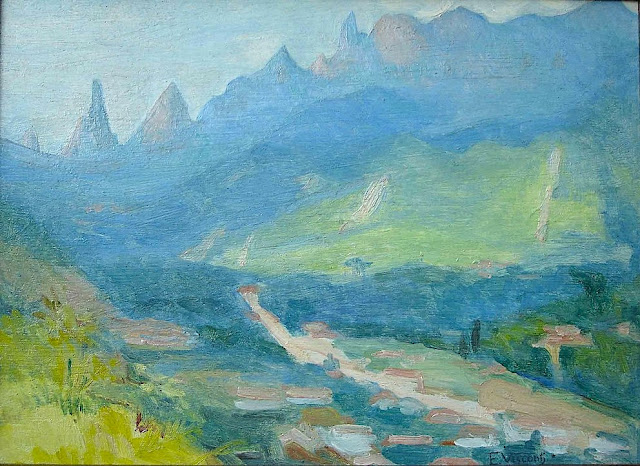
DEDO DE DEUS (2) PAINTED BY ELISEU VISCONTI

ELISEU VISCONTI (1866-1944) Dedo de Deus (1,682m - 5,551ft) Brazil


ELISEU VISCONTI (1866-1944)
Dedo de Deus (1,682m - 5,551ft)
Brazil


About this mainting
Eliseu Visconti painted a lot of times,the Dedo De Deus mountain in the Serra de Orgaos, in any season and in all possible light, at any time of day. It is THE  repetitive motif in his work, a bit like the Montagne Sainte-Victoire for Paul Cézanne or  the volcano Chimborazo for Frederic Edwin Church or Mount Everest for Nicholas Roerich.


The mountain
Dedo de Deus (The Finger of God) (1,682m - 5,551ft) is a peck whose outline resembles a hand pointing the index finger to the sky. It is one of the several geological monuments of Serra dos Órgãos which is located in Serra do Mar, between the cities of Petrópolis, Guapimirim and Teresópolis, in the state of Rio de Janeiro, in Brazil. The mountaineering in Brazil is closely linked to the achievement of the Dedo de deus. The peak is a state symbol Rio de Janeiro, appearing on its flag and coat of arms. As for the coat of arms of the State of Rio de Janeiro, the first section, occupying the upper half, is blue, representing the sky and symbolizing justice, truth and loyalty, with the silhouette of the Serra dos Órgãos, highlighting the Dedo de Deus. The symbol was created by the 1892 State Constitution and made official under the government of José Tomás da Porciúncula, with small differences over time. In 1912, José Guimarães Teixeira, Raul Carneiro and the brothers Américo, Alexandre and Acácio de Oliveira, all from Teresópolis, were the first to step on top of the rock formation.


The artist
Eliseu Visconti, born Eliseo d'Angelo Visconti was an Italian-born Brazilian painter, cartoonist, and teacher. He is considered one of the very few impressionist painters of Brazil. He is considered the initiator of the art nouveau in Brazil.
Thanks to a prize received in 1892, Visconti travelled to Paris, where he attended the École des Beaux Arts the following year. He also took classes at the Académie Julian and the École nationale supérieure des arts décoratifs, where he was a pupil of art nouveau master Eugène Grasset. He was accepted at the Salon de la Nationale des Beaux Arts and at the Salon of the Société of des Artistes Français. As one of the Brazilian representatives to the Exposition Universelle 1900 he exhibited the paintings Gioventú and Oréadas, for which he received a silver medal. Back in Brazil, Visconti exhibited in Rio de Janeiro and São Paulo, and obtained the first place in a contest for the drawing of postal stamps for the Brazilian Casa da Moeda. He traveled again to Europe, where he exhibited at the Paris Salon of 1905 the portrait of the artist Nicolina Vaz de Assis now at the Museu Nacional de Belas Artes. In this same year, he was invited to paint the stage curtain for the Teatro Municipal of Rio de Janeiro which he completed in his studio in Paris.
Decorative schemes executed for the National Library or Biblioteca Nacional in (Rio de Janeiro) date from this period as does another gold medal he received at the International Exhibition of Saint-Louis (Louisiana Purchase Exposition), in 1904, for the painting Recompensa de São Sebastião (see external links). The museum of Santiago of the Chile acquired his Sonho Místico (Mystical Dream) in 1912. In 1913, Visconti returned to Europe in order to paint large scale panels for the "foyer" of the Theatro Municipal do Rio de Janeiro. His plans to return were interrupted by the First World War so he stayed in France until 1920. The resulting paintings for the "foyer" were sent to Brazil during the war, in 1915. In 1922 his triptych "Lar" gained him the Medal of Honor in a large exhibition created in Rio de Janeiro to commemorate the first centennial of Brazilian Independence, the Exposição do Centenário. The following year Visconti painted the mural decoration of Rio de Janeiro's municipal council hall. In 1924, he painted the panel depicting the signature of the first Republican Constitution, for the old federal court, also in Rio de Janeiro.
_______________________________

2022 - Wandering Vertexes...
by Francis Rousseau

Friday, January 14, 2022

KANGCHENJUNGA PHOTOGRAPHED IN 1891 BY KURT BOECK

KURT BOECK (1855-1933) Kangchenjunga (8, 538m - 28,169 ft) India, Népal   In Kinchinjunga aus Südosten,  photo, 1891, Privtate coillection


KURT BOECK (1855-1933)
Kangchenjunga (8, 538m - 28,169 ft)
India, Népal 

In Kinchinjunga aus Südosten,  photo, 1891, Private coillection 


The artist
Kurt Karl Alexander Oskar Boeck was a German theater actor, climber, travel writer ans eventually early photographer. He began as an actor but in 1887when he had the opportunity to accompany a research expedition to Asia, especially to Persia and the Caucasus, he could not resist the temptation.
Researching and traveling in lesser-known, far-off lands told him so much that when he returned home from Asia he did not find a commitment that suited his wishes, he turned completely to this interesting profession. First, Boeck undertook in 1890 at his own expense an expedition to the Himalayas, where he took the glacier leader Hans Kerner from Tyrol and drove in the years 1893, 1895 and 1898-1899 again to India to thoroughly get to know the country in all parts. Boeck's lectures in numerous national and international associations on these and his other travels in Burma, China, America, Japan, Siberia, etc., have made him, as well as his articles in magazines, known to the general public.

The mountain
Kangchenjunga (8,586 m (28,169 ft) is the third highest mountain in the world. It lies partly in Nepal and partly in Sikkim, India. Kangchenjunga is the second highest mountain of the Himalayas after Mount Everest. Three of the five peaks – Main, Central and South – are on the border between North Sikkim and Nepal. Two peaks are in the Taplejung District, Nepal.
Kangchenjunga Main is the highest mountain in India, and the easternmost of the mountains higher than 8,000 m (26,000 ft). Until 1852, Kangchenjunga was assumed to be the highest mountain in the world, but calculations based on various readings and measurements made by the Great Trigonometrical Survey of India in 1849 came to the conclusion that Mount Everest, known as Peak XV at the time, was the highest. It is listed int the Eight Thousanders and as Seven Third Summits
Kangchenjunga is the official spelling adopted by Douglas Freshfield, A. M. Kellas, and the Royal Geographical Society that gives the best indication of the Tibetan pronunciation. Freshfield referred to the spelling used by the Indian Government since the late 19th century. There are a number of alternative spellings including Kangchendzцnga, Khangchendzonga, and Kanchenjunga. Local Lhopo people believe that the treasures are hidden but reveal to the devout when the world is in peril; the treasures comprise salt, gold, turquoise and precious stones, sacred scriptures, invincible armor or ammunition, grain and medicine. Kangchenjunga's name in the Limbu language is Senjelungma or Seseylungma, and is believed to be an abode of the omnipotent goddess Yuma Sammang.
It rises in a section of the Himalayas called Kangchenjunga Himal that is limited in the west by the Tamur River, in the north by the Lhonak Chu and Jongsang La, and in the east by the Teesta River. It lies about 128 km (80 mi) east of Mount Everest.
Allowing for further verification of all calculations, it was officially announced in 1856 that
Kangchenjunga was first climbed on 25 May 1955 by Joe Brown and George Band, who were part of a British expedition. They stopped short of the summit as per the promise given to the Chogyal that the top of the mountain would remain inviolate. Every climber or climbing group that has reached the summit has followed this tradition. Other members of this expedition included John Angelo Jackson and Tom Mackinon. In May 1979, Doug Scott, Peter Boardman and Joe Tasker established a new route on the North Ridge their third ascent which was the first one ever made without oxygen.
In 1983, Pierre Beghin made the first solo ascent accomplished without the use of supplemental oxygen. In 1992, Wanda Rutkiewicz was the first woman in the world to ascend and descend K2 and a world-renowned Polish climber, died after she insisted on waiting for an incoming storm to pass, which she did not survive. In 1998, Ginette Harrison was the first woman who climbed Kangchenjunga North face ; Gerlinde Kaltenbrunner, an Austrian mountaineer, was the second woman to reach the summit in 2006. In May 2014, the Bulgarian diabetic climber Boyan Petrov reached the peak without the use of supplemental oxygen

_______________________________
2022 - Wandering Vertexes...
by Francis Rousseau

Wednesday, December 1, 2021

OLYMPUS MONS (ON MARS) PHOTOGRAPHED BY NASA MARS GLOBAL SURVEYOR


NASA/MOLA SCIENCE TEAM Olympus Mons (21, 230m - 69,650ft) Planet Mars - Solar system

NASA MARS GLOBAL SURVEYOR  (1996-2007)
Olympus Mons (21, 230m - 69,650ft)
Mars (Solar system)

The Volcano
Olympus Mons (21, 230m / 21, 2 km-  69,650 ft /1 3 mi) is a very large shield volcano located on the planet Mars,  the largest volcano in the solar system. The massive Martian mountain towers high above the surrounding plains of the red planet, and may be biding its time until the next eruption.By one measure, it has a height of nearly 22 km (13.6 mi). Olympus Mons stands about two and a half times as tall as Mount Everest's height above sea level. It is the youngest of the large volcanoes on Mars, having formed during Mars's Hesperian Period. It had been known to astronomers since the late 19th century as the albedo feature Nix Olympica (Latin for "Olympic Snow"). Its mountainous nature was suspected well before space probes confirmed its identity as a mountain.
The volcano is located in Mars's western hemisphere at approximately 18.65°N 226.2°E, just off the northwestern edge of the Tharsis bulge. The western portion of the volcano lies in the Amazonis quadrangle (MC-8) and the central and eastern portions in the adjoining Tharsis quadrangle (MC-9).
Two impact craters on Olympus Mons have been assigned provisional names by the International Astronomical Union. They are the 15.6 km (9.7 mi)-diameter Karzok crater (18°25′N 131°55′W) and the 10.4 km (6.5 mi)-diameter Pangboche crater (17°10′N 133°35′W). The craters are notable for being two of several suspected source areas for shergottites, the most abundant class of Martian meteorites. Olympus Mons and a few other volcanoes in the Tharsis region stand high enough to reach above the frequent Martian dust-storms recorded by telescopic observers as early as the 19th century. The astronomer Patrick Moore pointed out that Schiaparelli (1835–1910) "had found that his Nodus Gordis and Olympic Snow [Nix Olympica] were almost the only features to be seen" during dust storms, and "guessed correctly that they must be high". The Mariner 9 spacecraft arrived in orbit around Mars in 1971 during a global dust-storm. The first objects to become visible as the dust began to settle, the tops of the Tharsis volcanoes, demonstrated that the altitude of these features greatly exceeded that of any mountain found on Earth, as astronomers expected. Observations of the planet from Mariner 9 confirmed that Nix Olympica was not just a mountain, but a volcano. Ultimately, astronomers adopted the name Olympus Mons for the albedo feature known as Nix Olympica.

The mission
Mars Global Surveyor (MGS) was an American robotic spacecraft developed by NASA's Jet Propulsion Laboratory and launched November 7, 1996. Mars Global Surveyor was a global mapping mission that examined the entire planet, from the ionosphere down through the atmosphere to the surface. As part of the larger Mars Exploration Program, Mars Global Surveyor performed monitoring relay for sister orbiters during aerobraking, and it helped Mars rovers and lander missions by identifying potential landing sites and relaying surface telemetry.
It completed its primary mission in January 2001 and was in its third extended mission phase when, on 2 November 2006, the spacecraft failed to respond to messages and commands. A faint signal was detected three days later which indicated that it had gone into safe mode. Attempts to recontact the spacecraft and resolve the problem failed, and NASA officially ended the mission in January 2007.
The Mars Orbiter Camera (MOC) science investigation used 3 instruments: a narrow angle camera that took (black-and-white) high resolution images (usually 1.5 to 12 m per pixel) and red and blue wide angle pictures for context (240 m per pixel) and daily global imaging (7.5 km per pixel). MOC returned more than 240,000 images spanning portions of 4.8 Martian years, from September 1997 and November 2006.[6] A high resolution image from MOC covers a distance of either 1.5 or 3.1 km long. Often, a picture will be smaller than this because it has been cut to just show a certain feature. These high resolution images may cover features 3 to 10 km long. When a high resolution image is taken, a context image is taken as well. The context image shows the image footprint of the high resolution picture. Context images are typically 115.2 km square with 240 m/pixel resolution.

The Mars Orbiter Laser Altimeter, or MOLA, is an instrument on the Mars Global Surveyor (MGS), a spacecraft that was launched on November 7, 1996. The mission of MGS was to orbit Mars, and map it over the course of approximately 3 years, which it did sucessfully, completing 4 1/2 years of mapping.
Determining the height of surface features on Mars is important to mapping it. To this end, MGS carried a laser altimeter on board. This instrument, MOLA, collected altimetry data until June 30, 2001. MOLA then operated as a radiometer until October 7, 2006.
This website will explain what MOLA is and how it works, and share some of the important discoveries about Mars that have been made using MOLA data.

_________________________________________

2021 - Wandering Vertexes...
by Francis Rousseau

Wednesday, October 13, 2021

THE MONT BLANC & THE MER DE GLACE BY JOHN RUSKIN

JOHN RUSKIN (1819-1900), The Mont Blanc (4,808.13 m - 15,776.7 ft) France - Italy border  In Mer de Glace Chamonix, watercolor on paper, 1849, Ruskin Foundation


JOHN RUSKIN (1819-1900),
The Mont Blanc (4,808.13 m - 15,776.7 ft)
France - Italy border

In Mer de Glace Chamonix, watercolor on paper, 1849, Ruskin Foundation

The painter  
John Ruskin was the leading English art critic of the Victorian era, as well as an art patron, draughtsman, watercolourist, a prominent social thinker and philanthropist. He wrote on subjects as varied as geology, architecture, myth, ornithology, literature, education, botany and political economy. His writing styles and literary forms were equally varied. Ruskin also penned essays and treatises, poetry and lectures, travel guides and manuals, letters and even a fairy tale. The elaborate style that characterised his earliest writing on art was later superseded by a preference for plainer language designed to communicate his ideas more effectively. In all of his writing, he emphasised the connections between nature, art and society. He also made detailed sketches and paintings of rocks, plants, birds, landscapes, and architectural structures and ornamentation. He was hugely influential in the latter half of the 19th century, and up to the First World War. After a period of relative decline, his reputation has steadily improved since the 1960s with the publication of numerous academic studies of his work. Today, his ideas and concerns are widely recognised as having anticipated interest in environmentalism, sustainability and craft.
Ruskin first came to widespread attention with the first volume of Modern Painters (1843), an extended essay in defence of the work of J. M. W. Turner in which he argued that the principal role of the artist is "truth to nature". From the 1850s he championed the Pre-Raphaelites who were influenced by his ideas. His work increasingly focused on social and political issues. Unto This Last (1860, 1862) marked the shift in emphasis. In 1869, Ruskin became the first Slade Professor of Fine Art at the University of Oxford, where he established the Ruskin School of Drawing. In 1871, he began his monthly "letters to the workmen and labourers of Great Britain", published under the title Fors Clavigera (1871–1884). In the course of this complex and deeply personal work, he developed the principles underlying his ideal society. As a result, he founded the Guild of St George, an organisation that endures today.

The mountain
Mont Blanc (in French) or Monte Bianco (in Italian), both meaning "White Mountain", is the highest mountain in the Alps and the highest in Europe after the Caucasus peaks. It rises 4,808.73 m (15,777 ft) above sea level and is ranked 11th in the world in topographic prominence. The Mont Blanc is one of the Seven Summit, which includes the highest mountains of each of the seven continents. Summiting all of them is regarded as a mountaineering challenge, first achieved on April 30, 1985 by Richard Bass. The 7 highest summit, (which are obviously 8 with 2 in Europe !) are : Mount Everest (8,848m), Aconcagua (6,961m), Mt Denali or Mc Kinley (6,194m), Kilimandjaro (5,895m), Mt Elbrus (5,642m), Mount Vinson (4,892m) and Mount Kosciuszko (2,228m) in Australia.
The Glacier
The Mer de Glace  ( Sea of Ice) is an alpine valley glacier located on the northern slope of the Mont-Blanc massif, in the French department of Haute-Savoie. It is formed by the confluence of the Tacul glacier and the Leschaux glacier and flows into the Arve valley, on the territory of the municipality of Chamonix-Mont-Blanc, giving rise to the Arveyron. The glacier is seven kilometers long, its supply basin has a maximum length of twelve kilometers and an area of ​​40 km2, while its thickness reaches 300 meters.
In the seventeenth century, the glacier, which descends into the valley and threatens homes, is feared by the population, so that only its terminal tongue is known, under the name of Glacier des Bois. Then finished by a natural cave, it is the subject of numerous paintings. Its current name was given to it in 1741 by William Windham during the exploration he carried out with his British compatriot Richard Pococke. Two decades later, Horace-Bénédict de Saussure, the future instigator of the first ascent of Mont Blanc, made several observations of the glacier and asked Marc-Théodore Bourrit to promote it. It thus contributes to the development of alpine tourism and to the visit of numerous personalities of letters as well as of the aristocracy; scientists carried out experiments there in the 19th century. To shelter them, three increasingly large and comfortable shelters were successively built in Montenvers. At the beginning of the 20th century, the Montenvers railway, leaving from Chamonix, was created. In the middle of the century, an ice cave was pierced for the first time in the Mer de Glace. Due to the attraction's success, a cable car was put into service in 1961 to access it, then replaced by a cable car in 1988. Since 1973, an underground hydroelectric power station has been using the meltwater from the glacier.
Almost a million visitors go to Montenvers every year to contemplate the Mer de Glace. During peak periods, half of them visit the ice cave. Three museums are also located on the site. Skiing is possible from the Aiguille du Midi in winter. However, the retreat of the glacier, measured since 1860-1870, causes a loss of thickness of 120 meters in a century in its terminal part. It causes difficulties at the level of the ice cave, where more and more steps are necessary to reach the gondola, and requires considering its upstream movement, like the catchment of the hydroelectric power station in 2011.
_______________________________


2021 - Wandering Vertexes...
by Francis Rousseau

Wednesday, September 1, 2021

MOUNT SNOWDON PAINTED BY J.M.W. TURNER


J.M.W. Turner (1775-1851), Mount Snowdon (1, 085 m -3,560 ft), United Kingdom (Wales),  In  "Mount Snowdon, Afterglow ", oil on canvas, 1800, Tate 
 
J.M.W. Turner (1775-1851)
Mount Snowdon (1, 085 m -3,560 ft)
United Kingdom (Wales)

In Mount Snowdon, Afterglow, oil on canvas, 1800, Tate

The mountain
Mount Snowdon (1, 085 m -3,560 ft),Yr Wyddfa in welsh, is the highest mountain in Wales and the highest point in the British Isles south of the Scottish Highlands. A 1682 survey estimated that the summit of Snowdon was at a height of 1,130 m - 3,720 feet ; in 1773, Thomas Pennant quoted a later estimate of 1,088 m- 3,568 ft above sea level at Caernarfon. Recent surveys give the height of the summit as 1,085 m -3,560 ft. The name Snowdon is from the Old English for "snow hill", while the Welsh name – Yr Wyddfa – means "the tumulus" or "the barrow", which may refer to the cairn thrown over the legendary giant Rhitta Gawr after his defeat by King Arthur. As well as other figures from Arthurian legend, the mountain is linked to a legendary Afanc (water monster) and the Tylwyth Teg (fairies). Mount Snowdon is located in Snowdonia National Park (Parc Cenedlaethol Eryri) in Gwynedd. It has been described as "probably the busiest mountain in Britain", with approximately 444,000 people having walked up the mountain in 2016. It is designated as a national nature reserve for its rare flora and fauna. The rocks that form Snowdon were produced by volcanoes in the Ordovician period, and the massif has been extensively sculpted by glaciation, forming the pyramidal peak of Snowdon and the Arêtes of Crib Goch and Y Lliwedd. The cliff faces on Snowdon, including Clogwyn Du'r Arddu, are significant for rock climbing, and the mountain was used by Edmund Hillary in training for the 1953 ascent of Mount Everest.
The summit can be reached by a number of well-known paths, and by the Snowdon Mountain Railway, a rack and pinion railway opened in 1896 which carries passengers the 4.7 miles (7.6 km) from Llanberis to the summit station.

The painter
The english painter Joseph Mallord William Turner was considered a controversial figure in his day, but is now regarded as the artist who elevated landscape painting to an eminence in the history of painting. Although renowned for his oil paintings, Turner is also one of the greatest masters of British watercolour landscape painting.  He is commonly known as "the painter of light" and his work is regarded as a Romantic preface to Impressionism.
In his thirties, Turner travelled widely in Europe, starting with France and Switzerland in 1802 and studying in the Louvre in Paris in the same year. He made many visits to Venice.  Turner's talent was recognized early in his life. Financial independence allowed Turner to innovate freely; his mature work is characterized by a chromatic palette and broadly applied atmospheric washes of paint. According to David Piper's The Illustrated History of Art, his later pictures were called "fantastic puzzles:" Turner was recognized as an artistic genius: influential English art critic John Ruskin described him as the artist who could most "stirringly and truthfully measure the moods of Nature."
Turner's major venture into printmaking was the Liber Studiorum (Book of Studies), seventy prints that he worked on from 1806 to 1819. The Liber Studiorum was an expression of his intentions for landscape art. The idea was loosely based on Claude Lorrain's Liber Veritatis (Book of Truth), where Lorrain had recorded his completed paintings; a series of print copies of these drawings, by then at Devonshire House, had been a huge publishing success. Turner's plates were meant to be widely disseminated, and categorized the genre into six types: Marine, Mountainous, Pastoral, Historical, Architectural, and Elevated or Epic Pastoral. His printmaking was a major part of his output, and a museum is devoted to it, the Turner Museum in Sarasota, Florida, founded in 1974 by Douglass Montrose-Graem to house his collection of Turner prints.
Turner placed human beings in many of his paintings to indicate his affection for humanity on the one hand (note the frequent scenes of people drinking or working or walking in the foreground), but its vulnerability and vulgarity amid the 'sublime' nature of the world on the other. 'Sublime' here means awe-inspiring, savage grandeur, a natural world unmastered by man, evidence of the power of God – a theme that romanticist artists and poets were exploring in this period. Although these late paintings appear to be 'impressionistic' and therefore a forerunner of the French school, Turner was striving for expression of spirituality in the world, rather than responding primarily to optical phenomena.
Turner used pigments like carmine in his paintings, knowing that they were not long-lasting, despite the advice of contemporary experts to use more durable pigments. As a result, many of his colours have now faded greatly.
John Ruskin says in his "Notes" on Turner in March 1878 : "His true master was Dr Monro; to the practical teaching of that first patron and the wise simplicity of method of watercolour study, in which he was disciplined by him and companioned by Girtin, the healthy and constant development of the greater power is primarily to be attributed; the greatness of the power itself, it is impossible to over-estimate. "

_______________________________
2021 - Wandering Vertexes...
by Francis Rousseau

Wednesday, July 28, 2021

THE MONT BLANC PAINTED BY JEAN-ANTOINE LINCK


JEAN-ANTOINE LINCK (1766-1843)
The Mont Blanc (4,808.73 m -15,777 ft)
France-Italy border

In Vue du Mont blanc à partir du Col de Balme, Estampe, 50 x50cm, 
Musée Alpin de Chamonix-Mont-Blanc


About this picture
This print represents the Chamonix valley seen from the Col de Balme. This point of view allows the spectator to embrace the major part of the Mont-Blanc massif and the valley bottom by following the course of the Arve. Jean-Antoine Linck offers a relatively realistic panorama, sometimes exaggerating the bristling of summits and seracs. In the foreground, the artist has placed a few figures who seem to be tourists in awe of the landscape accompanied by a guide leaning against the border post with his two mules. Linck was trained in Geneva in his father's workshop in the context of the "Fabrique" which brings together watchmakers, jewelers and painters on enamel. It was in this dynamic artistic environment of the second half of the 18th century that the first engravers appeared who made the Chamonix valley known through their watercolor prints. A real industry of landscape engraving is then set up. Linck is one of the greatest representatives of this artistic movement linked to the rise of alpine tourism and a new craze for the landscape. He creates high-quality etched works, very popular with travelers, which he sells in his Geneva boutique. In his "Manual of the traveler in Switzerland" of 1818, Ebel moreover advises the latter in order to find the best artists. He quotes Linck in particular and specifies that this print was worth 18 pounds, a fairly large sum for the time. Despite everything, the print is reproducible and cheaper than a painting. It therefore lends itself perfectly to the request of visitors to take with them views of the regions visited.

The artist
Jean-Antoine Linck, is a swiss painter and draftsman who lived and worked at the end of the 18th century and beginning of 19th century, at the time nature and mountains were up to date in high society in Switzerland and France.He is the son of Jean-Conrad, an enameller and engraver from Geneva who initiates his apprenticeship. He was then trained by Carl Hackert with Wolfgang Adam Toepffer. In 1802, he opened his own studio in Geneva, in the district of Montbrillant. His works, depicting the surroundings of Geneva, Savoy, the Alps and the Mont Blanc, were inspired by those of the great master of that " genre" Johann Ludwig Aberli and were successful with Josephine de Beauharnais, the French Empress and Catherine II, the Russian Empress, meanwhile alpine tourism began to develop

The mountain
The Mont Blanc (4,808.73 m -15,777 ft) or Monte Bianco, both meaning "White Mountain", is the highest mountain in the Alps and the highest in Europe after the Caucasus peaks. It is ranked 11th in the world in topographic prominence. The Mont Blanc is one of the Seven Summit, which includes the highest mountains of each of the seven continents. Summiting all of them is regarded as a mountaineering challenge, first achieved on April 30, 1985 by Richard Bass. The 7 highest summits, (which are obviously 8 with 2 in Europe !) are :
Mount Everest (8,848m), Aconcagua (6,961m), Mt Denali or Mc Kinley (6,194m), Kilimandjaro (5,895m), Mt Elbrus (5,642m), Mount Vinson (4,892m) and Mount Kosciuszko (2,228m) in Australia.
The mountain lies in a range called the Graian Alps, between the regions of Aosta Valley, Italy, and Savoie and Haute-Savoie, France. The location of the summit is on the watershed line between the valleys of Ferret and Veny in Italy and the valleys of Montjoie, and Arve in France. The Mont Blanc massif is popular for mountaineering, hiking, skiing, and snowboarding.
The three towns and their communes which surround Mont Blanc are Courmayeur in Aosta Valley, Italy, and Saint-Gervais-les-Bains and Chamonix in Haute-Savoie, France. A cable car ascends and crosses the mountain range from Courmayeur to Chamonix, through the Col du Géant. Constructed beginning in 1957 and completed in 1965, the 11.6 km (7¼ mi) Mont Blanc Tunnel runs beneath the mountain between these two countries and is one of the major trans-Alpine transport routes.
Since the French Revolution, the issue of the ownership of the summit has been debated.
From 1416 to 1792, the entire mountain was within the Duchy of Savoy. In 1723 the Duke of Savoy, Victor Amadeus II, acquired the Kingdom of Sardinia. The resulting state of Sardinia was to become preeminent in the Italian unification.[ In September 1792, the French revolutionary Army of the Alps under Anne-Pierre de Montesquiou-Fézensac seized Savoy without much resistance and created a department of the Mont-Blanc. In a treaty of 15 May 1796, Victor Amadeus III of Sardinia was forced to cede Savoy and Nice to France. A Sardinian Atlas map of 1869 showing the summit lying two thirds in Italy and one third in France.
Although the Franco-Italian border was redefined in both 1947 and 1963, the commission made up of both Italians and French ignored the Mont Blanc issue. In the early 21st century, administration of the mountain is shared between the Italian town of Courmayeur and the French town of Saint-Gervais-les-Bains, although the larger part of the mountain lies within the commune of the latter.

_______________________________________


2021 - Wandering Vertexes...
by Francis Rousseau