google.com, pub-0288379932320714, DIRECT, f08c47fec0942fa0 GRAVIR LES MONTAGNES... EN PEINTURE

Tuesday, September 20, 2022

MONT CLAPIER & MERCANTOUR RANGE BY MARSDEN HARTLEY


MARSDEN HARTLEY (1877–1943) The Mont Clapier and Mercantour Range (3 ,045m - 9,990ft) France- Italy Border  In Purple Mountains, Vence, oil on canvas, Phoenix Art Museum


MARSDEN HARTLEY (1877–1943)
The Mont Clapier and Mercantour Range (3 ,045m - 9,990ft)
France- Italy Border

In Purple Mountains, Vence, oil on canvas, Phoenix Art Museum

The painter 
Marsden Hartley  was an American Modernist painter, poet, and essayist.
Hartley began his art training at the Cleveland Institute of Art after his family moved to Cleveland, Ohio, in 1892.  He won a scholarship to the Cleveland School of Art.
In 1898, at age 22, he moved to New York City to study painting at the New York School of Art under William Merritt Chase, and then attended the National Academy of Design. Hartley was a great admirer of Albert Pinkham Ryder and visited his studio in Greenwich Village as often as possible. His friendship with Ryder, in addition to the writings of Walt Whitman and American transcendentalists Henry David Thoreau and Ralph Waldo Emerson, inspired Hartley to view art as a spiritual quest.
Hartley first traveled to Europe in April 1912, and he became acquainted with Gertrude Stein's circle of Avant-garde writers and artists in Paris.  Stein, along with Hart Crane and Sherwood Anderson, encouraged Hartley to write as well as paint.
In 1913, Hartley moved to Berlin, where he continued to paint and befriended the painters Wassily Kandinsky and Franz Marc. He also collected Bavarian folk art.  His work during this period was a combination of abstraction and German Expressionism, fueled by his personal brand of mysticism.
In Berlin, Hartley developed a close relationship with a Prussian lieutenant, Karl von Freyburg. References to Freyburg were a recurring motif in Hartley's work, most notably in Portrait of a German Officer (1914). Freyburg's subsequent death during the war hit Hartley hard, and he afterward idealized their relationship. Many scholars believe Hartley to have been gay, and have interpreted his work regarding Freyburg as embodying his homosexual feelings for him.
Hartley finally returned to the U.S. in early 1916. He lived in Europe again from 1921 to 1930, when he moved back to the U.S. for good.  He painted throughout the country, in Massachusetts, New Mexico, California, and New York. He returned to Maine in 1937, after declaring that he wanted to become "the painter of Maine" and depict American life at a local level.  This aligned Hartley with the Regionalism movement, a group of artists active from the early- to-mid 20th century that attempted to represent a distinctly "American art." He continued to paint in Maine, primarily scenes around Lovell and the Corea coast, until his death in Ellsworth in 1943. His ashes were scattered on the Androscoggin River. Most of his mountains paintings of Maine are nowadays in the MET collections.


The mountain
The Mont Clapier (3 ,045m - 9,990ft) is one of the main peaks in the eastern part of the Mercantour-Argentera massif, on the border ridge between France (Alpes-Maritimes) and Italy (Piedmont),
The summit is easily accessible on foot from the Nice refuge, in the Gordolasque valley. In winter, it is also one of the main ski touring routes in the area. The Italian side of Le Clapier bears the southernmost glacier in the Alps, Le Glacier du Clapier, 40 kilometers as the crow flies from the sea. This glacier is normally visible from the Pas Est du Mont Clapier. 

_______________________________

2022 - Wandering Vertexes...
by Francis Rousseau

Saturday, September 17, 2022

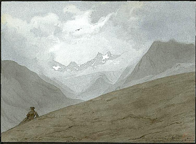
THE MOUNT VALIER SKETCHED BY EUGÈNE VIOLLET-LE-DUC

 
EUGÈNE VIOLLET-LE-DUC (1814-1879)  Mont Valier (2,838m - 9,311ft)   France (Pyrénées)  In Vue du fond de la vallée d'Azun prise de la montagne de Pourges, Hautes-Pyrénées , watercolor, 1833


EUGÈNE VIOLLET-LE-DUC (1814-1879)
 Mont Valier (2,838m - 9,311ft) 
 France (Pyrénées)

In Vue du fond de la vallée d'Azun prise de la montagne de Pourges, Hautes-Pyrénées, watercolor, 1833


The mountain
Mont Valier (2,838m - 9,311ft) is summit located in the Ariège Pyrenees, emblematic of Couserans, dominating the Angouls valley and its torrent, a short distance from the Spanish border.
The name comes from Valerius (Saint Valier, around 452), mythical first bishop of Couserans who would have climbed it. The Mont Valier belongs to the axial Pyrenean chain. Visible from afar, you can clearly see it from the plains of the Garonne and from Toulouse. The summit is located within the perimeter of the regional natural park of the Ariège Pyrenees. It is shared between the municipalities of Seix and Bordes - Uchentein.
Several stone crosses have succeeded each other at the top. If the first would have been the work of the first bishop of Couserans Valerius in the 5th century, Bernard Coignet de Marmiesse, another bishop of Couserans, had a marble cross erected there in the 1670s. The last was inaugurated in September 2012 after the destruction by anticlerical vandalism in 2011 of the granite cross placed in 1987. During the Second World War, an escape route from Saint-Girons to Esterri d'Àneu in Catalonia crossed the Mont Valier massif to cross the border at the difficult Col de la Pale de la Clauère. This "Chemin de la Liberté" - the name given in 1994 to the long-distance footpath that follows its route - allowed the escape of 782 people between 1940 and 1944 and remained operational, despite the increased surveillance of the Germans from 1943 and the denunciations on the part of French collaborators, and it functioned until the end of the war.
In 2000, a via ferrata was created towards the Estagnous refuge (2,246 m). It connects the refuge to the Long pond. Overlooking the round pond, it allows you to discover verticality in safety and a quality point of view. A departure is possible from the refuge or the Long pond. The route totals a length of 1,200 m, including 620 m equipped, for a one-way duration of 2 h 30 and 150 m of elevation. She is rated D.
By ministerial decree of July 5, 2005, a vast territory located in the municipality of Seix, including the national reserve of Mont Valier — created in 1937 (it is one of the oldest in the Pyrenees) — as well as almost all of the national territory of the Fonta massif, has been classified as a site of the Natura 2000 network (special protection area of ​​the Mont Valier massif)
The access routes are only on foot and for experienced and well-equipped hikers. The main access is from the Riberot valley, in the commune of Bordes-Uchentein, from the Plat de la Lau car park and via the Estagnous refuge (guarded in the right season, reservation required).


The artist
Eugène Emmanuel Viollet-le-Duc (not to be confused with the french writer Violette Leduc!) was a French architect and theorist, famous for his "restorations" of medieval buildings. But he was, as well, an excellent but less famous watercolorist, sketching quite a number of mountains and volcanoes all over Europe.
Born in Paris, he was a major Gothic Revival architect. His works were largely restorative and few of his independent building designs were ever realised. Strongly contrary to the prevailing Beaux-Arts architectural trend of his time, much of his design work was largely derided by his contemporaries. He was the architect hired to design the internal structure of the Statue of Liberty, but died before the project was completed.
During the early 1830s, a popular sentiment for the restoration of medieval buildings developed in France. Viollet-le-Duc, returning during 1835 from study in Italy, was commissioned by Prosper Mérimée to restore the Romanesque abbey of Vézelay. This work was the first of a long series of restorations; Viollet-le-Duc's restorations at Notre Dame de Paris with Jean-Baptiste Lassus brought him national attention. His other main works include Mont Saint-Michel, Carcassonne, Roquetaillade castle and Pierrefonds.
Viollet-le-Duc's "restorations" frequently combined historical fact with creative modification. For example, under his supervision, Notre Dame was not only cleaned and restored but also "updated", gaining its distinctive third tower (a type of flèche) in addition to other smaller changes. Another of his most famous restorations, the medieval fortified town of Carcassonne, was similarly enhanced, gaining atop each of its many wall towers a set of pointed roofs that are actually more typical of northern France. Many of these reconstructions were controversial. Viollet-le-duc wanted what he called ‘a condition of completeness' which never actually existed at any given time. This approach to restoration was particularly problematic when buildings survived in a mixture of styles. For instance, Viollet-le-Duc eliminated eighteenth-century additions to Notre Dame. Both his theory and his practice were strongly criticized on the grounds that only what had once been in place should be reconstructed. At the same time, in the cultural atmosphere of the Second Empire theory necessarily became diluted in practice: Viollet-le-Duc provided a Gothic reliquary for the relic of the Crown of Thorns at Notre-Dame in 1862, and yet Napoleon III also commissioned designs for a luxuriously appointed railway carriage from Viollet-le-Duc, in 14th-century Gothic style.
Among his restorations were:
- Churches :
Notre-Dame in Paris, Abbey of the Mont Saint-Michel, Basilica of St. Mary Magdalene in Vézelay, St. Martin in Clamecy, Sainte-Chapelle in Paris, Basilica of St. Denis near Paris, St. Louis in Poissy, Notre-Dame in Semur-en-Auxois, Basilica of St. Nazarius and St. Celsus in Carcasonne, Basilica of St. Sernin in Toulouse, Notre-Dame in Lausanne (Switzerland).
Town halls:
- Saint-Antonin-Noble-Val, Narbonne
Castles:
- Château de Roquetaillade in Bordeaux, Château de Pierrefonds, Fortified city of Carcassonne, Château de Coucy, Antoing in Belgium, Château de Vincennes in Paris.
When monuments was to much damaged, he sometimes obtain from the emperor Napoleon III the permission to entirely rebuilt it, like he did in Avignon with the Popes ramparts all around the city.

_______________________________

2022 - Wandering Vertexes...
by Francis Rousseau

Wednesday, September 14, 2022

THE CERVIN / MATTERHORN PAINTED BY FELIX VALOTTON

FELIX VALOTTON (1865-1925) Cervin / Matterhorn (4,478m -14,691ft) Switzerland - Italy border  In  Zermatt et le Cervin /Mateerhorn

 
FELIX VALOTTON (1865-1925)
Cervin / Matterhorn (4,478m -14,691ft)
Switzerland - Italy border

In  Zermatt et le Cervin /Matterhorn

The mountain
The Mont Cervin (4,478m -14,691ft) also known as the Matterhorn is an alpine summit located on the Swiss-Italian border between the canton of Valais and the Aosta Valley in Switzerland. It has several other names: Cervino in Italian, Grand'Bèca in Arpitan, Matterhorn in German. The Cervin / Matterhorn is the most famous mountain in Switzerland, including the pyramidal shape that it offers from the village of Zermatt, in the German-speaking part of the canton of Valais.
Its four sides are joined about 400 meters below the summit in a summit pyramid, called "roof." Its summit is a broad ridge about two meters, on which stand actually two summits: one called "Swiss summit," the farther east, and the "Italian summit" slightly lower (4,476 meters), on the west side of the ridge. The two are separated by a notch in the hollow of which a cross was laid in September 1901.


The painter
Félix Edouard Vallotton was a Swiss/French painter and printmaker associated (from 1892) with Les Nabis, a group of young artists that included Pierre Bonnard, Ker-Xavier Roussel, Maurice Denis, and Edouard Vuillard, with whom Vallotton was to form a lifelong friendship. During the 1890s, when Vallotton was closely allied with the avant-garde, his paintings reflected the style of his woodcuts, with flat areas of color, hard edges, and simplification of detail. His subjects included genre scenes, portraits and nudes. Examples of his Nabi style are the deliberately awkward Bathers on a Summer Evening (1892–93), now in the Kunsthaus Zurich, and the symbolist Moonlight (1895), in the Musée d'Orsay, Paris.
Vallotton's paintings of the post-Nabi period found admirers, and were generally respected for their truthfulness and their technical qualities, but the severity of his style was frequently criticized. Typical is the reaction of the critic who, writing in the March 23, 1910 issue of Neue Zurcher Zeitung, complained that Vallotton "paints like a policeman, like someone whose job it is to catch forms and colors. Everything creaks with an intolerable dryness ... the colors lack all joyfulness."
In its uncompromising character his art prefigured the New Objectivity that flourished in Germany during the 1920s, and has a further parallel in the work of Edward Hopper.

_______________________________

2022 - Wandering Vertexes...
by Francis Rousseau

Saturday, September 10, 2022

MORVEN SKETCHED BY A. G. CARRICK / H. M. THE KING CHARLES III

A. G. CARRICK / H.M KING CHARLES III former PRINCE OF WALES (bn.1948) Morven / A' Mhòr Bheinn ((871 m -2858 ft) United Kingdom (Scotland)  In View of Morven From Bovaglie, Balmoral, watercolour, 1994. Courtesy The  Royal Trust Collection

A. G. CARRICK / H.M KING CHARLES III former PRINCE OF WALES (bn.1948)
Morven / A' Mhòr Bheinn ((871 m -2858 ft)
United Kingdom (Scotland)

In View of Morven From Bovaglie, Balmoral, watercolour, 1994. Courtesy The  Royal Trust Collection

The mountain
Morven (871 m -2858 ft) in scottish galeic A' Mhòr Bheinn, is a Corbett (mountains between 2,500–3,000 feet (762.0–914.4 m) in height with a prominence over 500 feet (152.4 m); solely imperial measurement thresholds) in Aberdeenshire, Scotland. It has not to be confused with Morven in in Caithness.
The poet, Lord Byron, who spent some of his childhood in the area, mentions the mountain in his poem, When I Roved a Young Highlander mentioned in it Mary Duff, his first love.
The hill gives its name to one of the houses at Aboyne Academy.


The painter
Arthur George Carrick is actually H.M. the King Charles III, former Prince of Wales.
When he began showing his paintings, he was too nervous to display his name so displayed under a pseudonym. Arthur George are two of his names (Charles Phillip Arthur George) and one of his titles is Earl of Carrick. King Charles III is an experienced watercolourist.  He has been painting for most of his adult life, during holidays or when his official diary allows. King Charles' interest began during the 1970s and 1980s when he was inspired by Robert Waddell, who had been his art master at Gordonstoun in Scotland. In time, King Charles met leading artists such as Edward Seago, with whom he discussed watercolour technique, and received further tuition from John Ward, Bryan Organ and Derek Hill.
The Royal Family has a tradition of drawing and painting, and King Charles’ work first came to public notice at a 1977 exhibition at Windsor Castle at which other Royal artists included Queen Victoria, The Duke of Edinburgh and The Duke of York.
King Charles paints in the open air, often finishing a picture in one go and his favourite locations include The Queen's estate at Balmoral in Scotland and Sandringham House in Norfolk, England. Sometimes King Charles  III paints during his skiing holidays, and during overseas tours when possible.
The copyright of King Charles' watercolours belongs to A. G. Carrick Ltd, a trading arm of The King's Charities Foundation. Over the years King Charles III has agreed to exhibitions of his watercolours and of lithographs made from them, on the understanding that any income they generate goes to The Prince of Wales's Charitable Foundation.
Money from the sale of the lithographs also goes to the Foundation but the paintings themselves are never for sale.
In the 1980s King Charles III, then Prince of Wales,  began inviting young British artists to accompany him on official tours overseas and record their impressions, a tradition that has continued to this day.
Reference :
- The prince of Wales paintings  

_______________________________

2022 - Wandering Vertexes...
by Francis Rousseau 

Thursday, September 8, 2022

GUNUNG LAWU PAINTED BY ARTHUR ELAND


ARTHUR ELAND (1884-1948) Gunung Lawu ( 3,265 m - 10,712 ft) Indonesia (Java)  In "Mountains in Indonesia", oil on canvas, 1912, Private collection

ARTHUR ELAND (1884-1948)
Gunung Lawu ( 3,265 m - 10,712 ft)
Indonesia (Java)

In "Mountains in Indonesia", oil on canvas, 1912, Private collection


The painter 
There is not much biographical information about Arthur Eland, except that he was Leo Eland's twin brother. These two Dutch  brothers were born in 1884 in the Dutch East Indies on Java in Salatiga. After the death of Arthur and since the 1970s, many of his canvases and watercolors representing large Indonesian volcanic landscapes have gone into auctions especially at Christie's and have acquired unmistakable market value. Christie's classified him as a  "colonial impressionist painter". Impressionist he certainly  is, no doubt about it.

The mountain
Gunung Lawu is a massive compound stratovolcanostraddling the border between East Java and Central Java, Indonesia. The north side is deeply eroded and the eastern side contains parasitic crater lakes and parasitic cones. A fumarolic area is located on the south flank at 2,550 m. The only reported activity of Lawu took place in 1885, when rumblings and light volcanic ash falls were reported. The recent study provided insights into geothermal heat flow suggesting that Mt. Lawu is still active today.
Mount Lawu is the home of the God Parwatarajadewa(also called Hyang Girinatha in the manuscript Serat Centhini). The New Javanese manuscript Serat Manikmaya states that Mount Lawu is part of the eighteen sacred mountains of Central Java, and scholars agree that it had great religious significance to the Hindus of Java. Poerbatjaraka stated that the original name of Lawu is Katong, which means God. The name Katong is likely associated with the ruins of Mount Meru, the sacred five peaked mountain and center of the universe. This assosiation makes it likely that it is a seat of God, for which it is named. The last mention of this name was in the reign of Bhre Kertabhumi (1474-1478), and the first mention of Mount Lawu was in the Bhujangga Manik in the early 16th century, which indicates the name change took place between the 15th and 16th centuries, coinciding with the Islamic invasion.

___________________________________________
2022 - Wandering Vertexes...
by Francis Rousseau

Monday, September 5, 2022

PATON PEAK PAINTED BY EDWARD ADRIAN WILSON

EDWARD ADRIAN WILSON (1872-1912), Paton Peak (771 m -2530 ft) Antarctica (Beaufort Island)  In Beaufort Island, Ross Sea, watercolor, 1911

EDWARD ADRIAN WILSON (1872-1912),
Paton Peak (771 m -2530 ft)
Antarctica (Beaufort Island)

In Beaufort Island, watercolor, 1911, Royal Geographical Society Museum, London


The mountain
Paton Peak (771m-2,530 ft) is the highest point in Beaufort Island, an island in Antarctica's Ross Sea,  probably an  eroded basaltic stratovolcano of unknown age.  It is semi-circular in shape. It is the northernmost feature of the Ross Archipelago, lying 21 kilometres (13 miles) north of Cape Bird, Ross Island. It is approximately 18.4 km2 (7 square miles) in area. It was first charted by James Clark Ross in 1841. Ross named the island for Sir Francis Beaufort, hydrographer to the British Royal Navy. Much of the western side of the island is covered by moderately sloping ice fields with ice cliffs about 20 m (66 ft) high on the coast. The east and south sides of the island are mostly free of ice, with steep inaccessible cliffs that rise straight from the sea. Here the ice-free ground has a gentle slope and has ponds in summer and small meltwater streams that drain to the coast. The island has a small colony of breeding emperor penguins on nearshore sea ice at the northern end, a large Adélie penguin colony on a raised beach called Cadwalader Beach at the south-western end, and several breeding colonies of south polar skua.  It has been designated an Important Bird Area by BirdLife International.


The artist
Edward Adrian Wilson, nicknamed "Uncle Bill" was an English physician, polar explorer, natural historian, painter and ornithologist. Wilson took part in two British expeditions to Antarctica, the Discovery Expedition (1901-1904) and the tragic Terra Nova Expedition (1907-1912), both under the leadership of Scott.
Dr. Edward A. Wilson is widely regarded as one of the finest artists ever to have worked in the Antarctic. Sailing with Captain Scott aboard 'Discovery' (1901-1904), he became the last in a long tradition of 'exploration artists' from an age when pencil and water-colour were the main methods of producing accurate scientific records of new lands and animal species. He combined scientific, topographical and landscape techniques to produce accurate and beautiful images of the last unknown continent. Such was the strength of his work that it also helped to found the tradition of modern wildlife painting. In particular Wilson captured the essence of the flight and motion of Southern Ocean sea-birds on paper.
Returning with Captain Scott aboard 'Terra Nova' (1910-1913) as Chief of Scientific Staff, he continued to record the continent and its wildlife with extraordinary deftness. Chosen to accompany Captain Scott to the South Pole, his last drawings are from one of the most famous epic journeys in exploration history. Along with his scientific work, Wilson's pencil recorded the finding of Roald Amundsen's tent at the South Pole by Captain Scott. Wilson died, along with the other members of the British Pole Party, during the return journey, in March 1912. The drawings and paintings were created at considerable personal cost in the freezing conditions in which Wilson worked. He often suffered severely from the cold whilst sketching and also from snow-blindness, or sunburn of the eye. They provide a remarkable testament to one of the great figures of the heroic age of Antarctic exploration. The book has been produced as a companion volume to 'Edward Wilson's Nature Notebooks' by two of Wilson's great nephews, to mark the centenary of his death.

_______________________________
2022 - Wandering Vertexes..
Un blog de Francis Rousseau

Friday, September 2, 2022

MOUNT ASPIRING / TITETEA BY LAURENCE WILLIAM WILSON


LAURENCE WILLIAM WILSON (1851-1912) Mount Aspiring / Tititea (3, 033 m -9,951 ft) New Zealand  In Mount Aspiring, Matukituki River, watercolour, Christchurh Art Gallery- Te Puna o Waiwhetu.


LAURENCE WILLIAM WILSON (1851-1912)
Mount Aspiring / Tititea (3, 033 m -9,951 ft)
New Zealand

In Mount Aspiring, Matukituki River, watercolour,
Christchurh Art Gallery- Te Puna o Waiwhetu.


The mountain
Mount Aspiring / Tititea is New Zealand's highest mountain outside the Aoraki/Mount Cook region.
Set within Otago's Mount Aspiring National Park, it has a height of 3,033 metres (9,951 ft). Māori named it Tititea, which translates as Glistening Peak. It was named in December 1857 by the Chief Surveyor for the Otago Province, John Turnbull Thomson.[2] It is also often called 'the Matterhorn of the South,' for its pyramidal peak when seen from the Matukituki River. The first ascent was on 23 November 1909 by Major Bernard Head and guides Jack Clarke and Alec Graham.[3] Head's party climbed to the summit ridge by the west face from the Bonar Glacier, a route not repeated until 1965.
Mount Aspiring / Tititea sits slightly to the west of the main divide, 30 kilometres west of Lake Wanaka.[2] It lies at the junction of three major glacial systems — the Bonar Glacier, which drains into the Waipara River, and the Volta and Therma Glaciers, which both drain into the Waitoto River. The Waipara is a tributary of the Arawhata River, and both the Arawhata and Waitoto Rivers flow out to the west coast in between Haast and Jackson Bay.


The painter
Laurence William Wilson emigrated to Auckland in 1877 and then travelled extensively to settle in Dunedin in 1884. He painted in both oils and watercolours, became a painting companion of George O'Brien and a teacher. One of his pupils was the Dunedin artist Alfred O'Keefe. In 1895, LW Wilson together with Grace Joel, Alfred O'Keefe, Jane Wimperis and Girolami Nerli formed the Easel Club , a breakaway from the Dunedin Establishment, which offered a programme of special classes and the introduction of a professional lady model for life drawing. In 1904 LW Wilson left Dunedin for Melbourne where he spent 5 months on a commissioned painting of the city before he set out for England, eventually returning to New Zealand via India and Africa. He exhibited with the Canterbury Society of Arts in 1882 and the Otago Art Society between 1994 and 1904. His work was included in the NZ and South Seas Exhibition Dunedin 1889-90 and at the St Louis Exposition in 1904. LW Wilson is represented in the collections of all the major public galleries in New Zealand.

___________________________________________

2022 - Wandering Vertexes...
by Francis Rousseau

Wednesday, August 31, 2022

CHIMBORAZO PAINTED BY FREDERIC EDWIN CHURCH

FREDERIC EDWIN CHURCH (1826-1900) El Chimborazo (6,263 m -20,548 ft) Ecuador  In Mount Chimborazo Shown From Riobamba, Ecuador, 1857, Brush and oil on thin board, 29.1 x 44.1 cm (11 7/16 x 17 3/8 in.) Smithsonian/ Cooper Hewitt, Smithsonian Design Museum

FREDERIC EDWIN CHURCH (1826-1900)
El Chimborazo (6,263 m -20,548 ft)
Ecuador

In Mount Chimborazo Shown From Riobamba, Ecuador, 1857, Brush and oil on thin board,
29.1 x 44.1 cm (11 7/16 x 17 3/8 in.) Smithsonian/ Cooper Hewitt, Smithsonian Design Museum

 
The mountain
Chimborazo (6,263 m -20,548 ft) is a currently inactive stratovolcano in the Cordillera Occidental range of the Andes ans the highest mountain in Ecuador and the Andes north of Peru ; it is higher than any more northerly summit in the Americas. Chimborazo is not the highest mountain by elevation above sea level, but its location along the equatorial bulge makes its summit the farthest point on the Earth's surface from the Earth's center. Chimborazo is at the main end of the Ecuadorian Volcanic Arc, north west of the town of Riobamba. Chimborazo is in la Avenida de los Volcanes (the Avenue of Volcanoes) west of the Sanancajas mountain chain. Carihuairazo, Tungurahua, Tulabug, and El Altar are all mountains that neighbor Chimborazo. The closest mountain peak, Carihuairazo, is 5.8 mi (9.3 km) from Chimborazo. There are many microclimates near Chimborazo, varying from desert in the Arenal to the humid mountains in the Abraspungo valley. Its last known eruption is believed to have occurred around A.D. 550. Until the beginning of the 19th century, it was thought that Chimborazo was the highest mountain on Earth (measured from sea level), and such reputation led to many attempts on its summit during the 17th and 18th centuries. In 1746, the volcano was explored by French academicians from the French Geodesic Mission. Their mission was to determine the sphericity of the Earth. Their work along with another team in Lapland established that the Earth was an oblate spheroid rather than a true sphere. They did not reach the summit of Chimborazo. In 1802, during his expedition to South America, Baron Alexander von Humboldt, accompanied by Aimé Bonpland and the Ecuadorian Carlos Montufar, tried to reach the summit. From his description of the mountain, it seems that before he and his companions had to return suffering from altitude sickness they reached a point at 5,875 m, higher than previously attained by any European in recorded history. (Incans had reached much higher altitudes previously; see Llullaillaco). In 1831, Jean-Baptiste Boussingault and Colonel Hall reached a new "highest point", estimated to be 6,006 m. On 4 January 1880, the English climber Edward Whymper reached the summit of Chimborazo. The route that Whymper took up Chimborazo is now known as the Whymper route. Edward Whymper, and his Italian guides Louis Carrel and Jean-Antoine Carrel, were the first Europeans to summit a mountain higher than 20,000 feet. As there were many critics who doubted that Whymper had reached the summit, later in the same year he climbed to the summit again, choosing a different route (Pogyos) with the Ecuadorians David Beltrбn and Francisco Campaсa.


The painter
Frederic Edwin Church was an American landscape painter born in Hartford, Connecticut. He was a central figure in the Hudson River School of American landscape painters, perhaps best known for painting large panoramic landscapes, often depicting mountains, waterfalls, and sunsets, but also sometimes depicting dramatic natural phenomena that he saw during his travels to the Arctic and Central and South America. Church's paintings put an emphasis on light and a romantic respect for natural detail. In his later years, Church painted classical Mediterranean and Middle Eastern scenes and cityscapes. Church was the product of the second generation of the Hudson River School and the pupil of Thomas Cole, the school’s founder. The Hudson River School was established by the British Thomas Cole when he moved to America and started painting landscapes, mostly of mountains and other traditional American scenes. Both Cole and Church were devout Protestants and the latter's beliefs played a role in his paintings especially his early canvases. Church did differ from Cole in the topics of his paintings: he preferred natural and often majestic scenes over Cole's propensity towards allegory.
Church, like most second generation Hudson River School painters, used extraordinary detail, romanticism, and luminism in his paintings. Romanticism was prominent in Britain and France in the early 1800s as a counter-movement to the Enlightenment virtues of order and logic. Artists of the Romantic period often depicted nature in idealized scenes that depicted the richness and beauty of nature, sometimes also with emphasis on the grand scale of nature.
This tradition carries on in the works of Frederic Church, who idealizes an uninterrupted nature, highlighted by creating excruciatingly detailed art. The emphasis on nature is encouraged by the low horizontal lines, and preponderance of sky to enhance the wilderness; humanity, if it is represented, is depicted as small in comparison with the greater natural reality. The technical skill comes in the form of Luminism, a Hudson River School innovation particularly present in Church's works. Luminism is also cited as encompassing several technical aspects, which can be seen in Church’s works. One example is the attempt to “hide brushstrokes” which makes the scene seem more realistic and lessen the artist’s presence in the work. Most importantly is the emphasis on light (hence luminism) in these scenes. The several sources of light create contrast in the pictures that highlights the beauty and detailed imagery in the painting.
_________________________________________

2022 - Wandering Vertexes...
by Francis Rousseau


Sunday, August 28, 2022

CINQUE TORRI PAINTED BY EDWARD H. COMPTON


EDWARD H. COMPTON (1881-1960) Cinque Torri (2,361 m  -7,746 ft) Italy  In "Cinque Torri, Bei Cortina,Süd Tirol", 1930, oil on canvas


EDWARD H. COMPTON (1881-1960)
Cinque Torri (2,361 m  -7,746 ft)
Italy

In "Cinque Torri, Bei Cortina,Süd Tirol", 1930, oil on canvas


The mountains
Cinque Torri  (2,361 m  -7,746 ft) (sometimes named also Cinque Torri di Averau) comprise a small rock formation belonging to Nuvolao group in the Dolomiti Ampezzane (part of the Eastern Dolomites) north-west of San Vito di Cadore and south-west of Cortina d'Ampezzo.  Cinque Torri, as all the other mountains in the area, are made of dolomite, with a particular pale grey colour. The group is formed by five towers (which give the name to the mountain) with a maximum elevation of 2,361 m (Torre Grande). Every "tower" has its own name:Torre Grande, the highest one has three very appealing peaks for rock climbers: Cima Nord, Cima Sud e Cima Ovest. They are located in the south-west area of the valley of Cortina d'Ampezzo, north of the Averau mountain, of which Cinque Torri can be considered a part. In the Cinque Torri area there are the following mountain huts :Rifugio Cinque Torri, m 2,137. During summer it is possible to make excursions in the woods and on paths, among which are the Alta Via 1 of the Dolomites, the "Muraglia di Giau". The towers also provide good and popular rock climbing with various routes at a range of grades up all of the towers.  In winter, Cinque Torri belong to an important ski area, whose tracks are part of the wider Dolomiti Superski area. They are thus linked to the nearby mountains Lagazuoi and Col Gallina. Until a few years ago it was possible to ski only towards Lagazuoi - Col Gallina - Cinque Torri, but beginning in the winter season of 2008–2009, it has been also possible to ski downhill from the Cinque Torri area to the higher area of Falzarego Pass by means of the "Croda Negra" lift and the corresponding track beyond Averau mountain. This area was theater of conflict between Italian and Austro-Hungarian troops during World War I; countless testimonies of the fighting and of the war shelters built by the Italian army are present and have been recently rebuilt, to create an open-air museum with historical itineraries.

The painter
Edward Harrison Compton (1881–1960) not to be confused with his father Edward Theodore Compton (1849-1921) was a German landscape painter and illustrator of English descent. Compton was born in Feldafing in Upper Bavaria, Germany, the second son of notable landscape painter Edward Theodore Compton. He received his early art training from his father, and after a period of study in London at the Central School of Arts and Crafts settled back in Bavaria. Like his father he was inspired by the Alps to become a mountain painter ("bergmaller") working in both oils and watercolour. However, an attack of Polio at the age of 28 meant that he had to find more accessible landscapes to paint in Germany, England northern Italy and Sicily. He also provided illustrations for several travel books published by A & C Black. Compton exhibited at galleries in Munich and Berlin, and also in England at the Royal Academy in London and in Bradford. He died in Feldafing in 1960.
He had two sisters, both of whom were artists: Marion Compton, the flowers and still-life painter, and Dora Keel-Compton, flower and mountain painter.

____________________________________________________________-
2022 - Wandering Vertexes...
Un blog de Francis Rousseau

Thursday, August 25, 2022

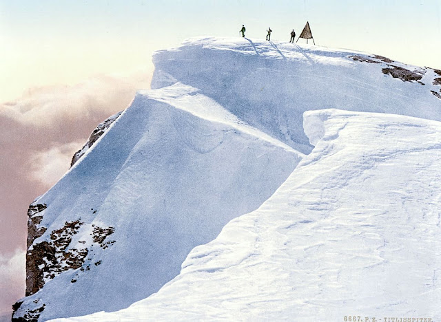
THE TITLIS IN VINTAGE POSTCARDS 1890

VINTAGE POSCARDS Titlis (3,238 m -10,623ft) Switzerland  In " Titlis Spitze, Unterwald - La Suisse en Couleur " postcard, 1890, The Library of Congress Photographs Division, Washington DC

VINTAGE POSCARDS
Titlis (3,238 m -10,623ft)
Switzerland

In " Titlis Spitze, Unterwald - La Suisse en Couleur " postcard, 1890,
The Library of Congress Photographs Division, Washington DC


The mountain
Titlis  (3,238 m - 10,623 ft) is a mountain of the Uri Alps, located on the border between the cantons of Obwalden and Bern. It is the highest summit of the range north of the Susten Pass, between the Bernese Oberland and Central Switzerland. It is mainly accessed from Engelberg (OW) on the north side and is famous as the site of the world's first rotating cable car.  The cable car system connects Engelberg (996 m (3,268 ft)) to the summit of Klein Titlis (3,028 m (9,934 ft)) through the three stages of Gerschnialp (1,262 m (4,140 ft)), Trübsee (1,796 m (5,892 ft)) and Stand (2,428 m (7,966 ft)), although somewhat recently, a newer, direct route was created that bypassed Gerachnialp, going directly to Trübsee.
The last part of cable car leads above the glacier. At Klein Titlis, it is possible to visit an illuminated glacier cave from an entrance within the cable-car station, which also includes shops and restaurants. The Titlis Cliff Walk, the highest elevation suspension bridge in Europe, opened in December 2012, giving views across the Alps. Many people use Titlis as a cheaper and easier option than Jungfraujoch.
In earlier times, Titlis was known under the names Wendenstock or Nollen. The Reissend Nollen and the Wendenstöcke are the nearest western neighbours to the mountain, slightly lower than Titlis, but with sharp rugged peaks. In a document of 1435 the mountain is called Tuttelsberg(Tutilos mountain), referencing to a man named Tutilos, who was probably a local farmer. The name, from Tutilos Berg, became Titlisberg and later Titlis.
The first ascent of Titlis was probably made in the year 1739. It was done by Ignaz Hess, J. E. Waser and two other men from Engelberg.  The first written evidence of an ascent is found in the Engelberger Dokumente. They mention a party of four men that reached the summit in 1744.
 On 21 January 1904 the first ski ascent of Titlis was made by Joseph Kuster and Willi Amrhein. In March 1967 the cable car to Klein Titlis (3,032 m) was inaugurated. In December 2012, the Titlis Cliff Walk opened to commemorate the 110th anniversary of the Engelberg-Gerschnialp cableway.


Vintage postcards
Postcards were colorized as soon as they appeared on the market at the end of 19th century ; the photos were then repainted by hand by women with very fine brushes, then a varnish was applied to fix these colors which were always very contrasting... and sometimes very far from reality!
Postcards became popular at the turn of the 20th century, especially for sending short messages to friends and relatives. They were collected right from the start, and are still sought after today by collectors of pop culture, photography, advertising, wartime memorabilia, local history, and many other categories. Postcards were an international craze, published all over the world. The Detroit Publishing Co. and Teich & Co. were two of the major publishers in the U.S, and sometimes individuals printed their own postcards as well. Yvon were the most famous in France. Many individual or anonymous publishers did exist around the world and especially in Africa and Asia (Japan, Thailand, Nepal, China, Java) between 1920 and 1955. These photographer were mostly local notables, soldiers, official guides belonging to the colonial armies (british french, belgium...) who sometimes had rather sophisticated equipment and readily produced colored photograms or explorers, navigators, climbers (Vittorio Sella and the Archiduke of Abruzzi future king of Italy remains the most famous of them).
There are many types of collectible vintage postcards.
Hold-to-light postcards were made with tissue paper surrounded by two pieces of regular paper, so light would shine through. Fold-out postcards, popular in the 1950s, had multiple postcards attached in a long strip. Real photograph postcards (RPPCs) are photographs with a postcard backing.
Novelty postcards were made using wood, aluminum, copper, and cork. Silk postcards–often embroidered over a printed image–were wrapped around cardboard and sent in see-through glassine paper envelopes; they were especially popular during World War I.
In the 1930s and 1940s, postcards were printed on brightly colored paper designed to look like linen.
Most vintage postcard collectors focus on themes, like Christmas, Halloween, portraits of movie stars, European royalty and U.S. presidents, wartime imagery, and photos of natural disasters or natural wonders. Not to mention cards featuring colorful pictures by famous artists like Alphonse Mucha, Harrison Fisher, Ellen Clapsaddle, and Frances Brundage.

__________________________________________
2022 - Wandering Vertexes...
by Francis Rousseau


Monday, August 22, 2022

LUSHAN / 庐山 or MOUNT LU SKETCHED BY JEAN-BAPTISTE NÉE


JEAN-BAPTISTE NÉE (b.1986) Lushan / 庐山 or Mount Lu (1,474m- 4,834ft) China  In Lushan ,Chine, Lavis 2018, 19x 28cm , Collection privée ©Jean-Baptiste Née @jeanbaptiste.nee

JEAN-BAPTISTE NÉE (b.1986)
Lushan / 庐山 or Mount Lu (1,474m- 4,834ft)
China

In Lushan ,Chine, Lavis 2018, 19x 28cm , Collection privée ©Jean-Baptiste Née
@jeanbaptiste.nee


The artist
Jean-Baptiste Née, born in 1986. is a french painter, scenographer and visual artist, graduated from Arts-Décoratifs of Paris in 2012. Jean-Baptiste Née works in the mountains and high mountains, always in situ, in direct confrontation with the movements of the earth and water and wind. He gives a growing place for the action of the elements on the work in progress (rain, snow, frost, etc.). He established his "large workshop" in the Swiss Alps or in the Vercors massif - especially in winter -, as well as during long hikes in the Italian Alps. In the winter of 2018, he worked in the massifs of Wudangshan and Lushan, in China, (see above) and became interested in the Taoist notion of "Sky" (t’ien 天).
Since 2016, Jean-Baptiste Née exhibits regularly in galleries in France and Switzerland. His workshop is in Montreuil, France.

The mountain
Mount Lu or Lushan (庐山) ( (1,474m- 4,834ft) is situated in the northern part of Jiangxi province in southeastern China, and is one of the most renowned mountains in the country. Mount Lushan is one of the spiritual centres of Chinese civilization. Buddhist and Taoist temples, along with landmarks of Confucianism, where the most eminent masters taught, blend effortlessly into a strikingly beautiful landscape which has inspired countless artists who developed the aesthetic approach to nature found in Chinese culture.
The oval-shaped mountains are about 25 km long and 10 km wide, and neighbors Jiujiang city and the Yangtze River to the north, Nanchang city to the south, and Poyang Lake to the east. Its highest point is Dahanyang Peak (1,474m- 4,834ft) and is one of the hundreds of steep peaks that towers above a sea of clouds that encompass the mountains for almost 200 days out of the year. Mount Lu is known for its grandeur, steepness, and beauty, and is part of Lushan National Park, a UNESCO World Heritage Site since 1996, and a prominent tourist attraction, especially during the summer months when the weather is cooler.
Lushan was a summer resort for Western missionaries in China. Absalom Sydenstricker, the father of Pearl Buck was one of the first five missionaries to acquire property in the Kuling Estate on the mountain.
More about Mount Lu

____________________________________

2022- Wandering Vertexes.
A blog by Francis Rousseau

Friday, August 19, 2022

THE K2 PEAK PHOTOGRAPHED BY VITTORIO SELLA IN 1909


VITTORIO SELLA (1859-1843)    The K2  peak (8,611m - 28,251 ft)  China - Pakistan border  Photographed during the 1909 expedition  led by Prince Luigi Amedeo, Duke of the Abruzzi

VITTORIO SELLA (1859-1843)  
 The K2  peak (8,611m - 28,251 ft) 
China - Pakistan border

Photographed during the 1909 expedition 
led by Prince Luigi Amedeo, Duke of the Abruzzi 

The artist
Vittorio Sella is a mountain italian climber and photographer who took his passion for mountains from his uncle, Quintino Sella, founder of the Italian Alpine Club.  He accomplished many remarkable climbs in the Alps, the first wintering in the Matterhorn and Mount Rose (1882) and the first winter crossing of Mont Blanc (1888).
He took part in various expeditions outside Italy:
- Three in the Caucasus in 1889, 1890 and 1896 where a summit still bears his name;
- The ascent of Mount Saint Elias in Alaska in 1897;
- Sikkim and Nepal in 1899;
- Possibly climb Mount Stanley in Uganda in 1906 during an expedition to the Rwenzori;
- Recognition at K2  in 1909 (aAbove)
- In Morocco in 1925.
During expeditions in Alaska, Uganda and Karakoram (K2), he accompanied the Duke of Abruzzi, Prince Luigi Amedeo di Savoia.
Sella continues the practice of climbing into his old age, completing his final attempt in the Matterhorn at the age of 76; a climb he had to interrupt the rise following an accident in which one of his guides injured. He died in his hometown during World War II.  His photographic collection is now managed by the Sella Foundation.
His photos mountain are still  considered today to be among the finest ever made.
Jim Curran believes that "Sella remains probably the greatest photographer of the mountain.  His name is synonymous with technical perfection and aesthetic refinement. "
The quality of the pictures of Vittorio Sella is partly explained by the use of a view camera 30 × 40 cm, despite the difficulty of the transportation of such a device, both heavy and fragile in places inaccessible; to be able to transport it safely, he had to make special pieces that can be stored in saddle bags.  His photographs have been widely distributed, either through the press or in the galleries, and were unanimously celebrated; Ansel Adams, who was able to admire thirty-one in an exhibition that was organized at Sella American Sierra Club, said they inspired him "a religious kind of sense of wonder."  Many of his pictures were taken in the mountains for the very first time in the History, which give them a much artistic, historical  but also scientific value ; for example, one could measure the decline in the Rwenzori glaciers in Central Africa.

The mountain 
K2 peak (8,611m - 28,251 ft)  also known as Mount Godwin-Austen or Chhogori is the second highest mountain in the world, after Mount Everest. It is located on the China-Pakistan border between Baltistan, in the Gilgit–Baltistan region of northern Pakistan, and the Taxkorgan Tajik Autonomous County of Xinjiang, China.
The name K2 is derived from the notation used by the Great Trigonometric Survey of British India. Thomas Montgomerie made the first survey of the Karakoram from Mount Haramukh, some 210 km (130 miles) to the south, and sketched the two most prominent peaks, labeling them K1 and K2.
The policy of the Great Trigonometric Survey was to use local names for mountains wherever possible and K1 was found to be known locally as Masherbrum. K2, however, appeared not to have acquired a local name, possibly due to its remoteness. The mountain is not visible from Askole, the last village to the south, or from the nearest habitation to the north, and is only fleetingly glimpsed from the end of the Baltoro Glacier, beyond which few local people would have ventured. The name Chogori, derived from two Balti words, chhogo ("big") and ri ("mountain")  has been suggested as a local name, but evidence for its widespread use is scant. It may have been a compound name invented by Western explorers or simply a bemused reply to the question "What's that called?" It does, however, form the basis for the name Qogir (simplified Chinese: 乔戈里峰; traditional Chinese: 喬戈里峰; pinyin: Qiбogēlǐ Fēng) by which Chinese authorities officially refer to the peak. Other local names have been suggested including Lamba Pahar ("Tall Mountain" in Urdu) and Dapsang, but are not widely used.
Lacking a local name, the name Mount Godwin-Austen was suggested, in honor of Henry Godwin-Austen, an early explorer of the area, and while the name was rejected by the Royal Geographical Society, it was used on several maps, and continues to be used occasionally.
The surveyor's mark, K2, therefore continues to be the name by which the mountain is commonly known. It is now also used in the Balti language, rendered as Kechu or Ketu (Urdu: کے ٹو‎). The Italian climber Fosco Maraini argued in his account of the ascent of Gasherbrum IV that while the name of K2 owes its origin to chance, its clipped, impersonal nature is highly appropriate for so remote and challenging a mountain. He concluded that it was ...
K2 is the highest point of the Karakoram range and the highest point in both Pakistan and Xinjiang.

Tuesday, August 16, 2022

RAS DASHAN SKETCHED BY HENRY SALT


HENRY SALT (1780-1827) Ras Dashen (4,550 m - 14,930 ft) Ethiopia

HENRY SALT (1780-1827)
Ras Dashen (4,550 m - 14,930 ft)
Ethiopia

In Mucculla in Abyssinia (Ethiopia), Handcolored aquatints 1809.
King Geroge III topographical collection

The mountain
Ras Dashan (4,550 m - 14,930 ft) also known as Ras Dashen or Ras Dejen, is the highest mountain in Ethiopia and fourteenth highest peak in Africa. Located in the Simien Mountains National Park in the Amhara Region North Gondar, The English form, "Ras Dashen" is a corruption of its Amharic name, "Ras Dejen", the term used by the Ethiopian Mapping Authority (EMA) which alludes to the traditional head or general who fights in front of the Emperor.
According to Erik Nilsson, Ras Dashan is the eastern peak of the rim of "an enormous volcano, the northern half of which is cut down about [a] thousand metres by numerous ravines, draining into the Takkazzi River." Its western counterpart is Mount Biuat (4,437 meters), separated by the valley of the Meshaha river. The mountain often sees violent snowfalls during the night, but given that day and night temperatures vary greatly, the snow is almost completely melted in a few hours (during the hottest period of the year), for the temperature may be over 5 degrees Celsius by midday. In winter snow falls rarely, since the majority of Ethiopia's yearly rainfall is in the summer, but if it does it usually lasts for weeks or months. The first recorded ascent by a European was in 1841, by French officers Ferret and Galinier. There is no verifiable evidence of earlier ascents by locals, but the summit climate and conditions are relatively hospitable, and there are nearby high altitude pastoral settlements. A small fort is still partially standing at around 4,300 metre SRTM data.

The artist
Henry Salt was an English artist, traveller, collector of antiquities, diplomat, and Egyptologist.
After a time as a portrait painter, Salt was permitted to travel with the English nobleman George Annesley, Viscount Valentia as his secretary and draughtsman after being recommended by Thomas Simon Butt. They started on an eastern tour in June 1802, traveling on the British East India Company's extra (chartered) ship Minerva to India via the Cape Colony. In 1805, Valentia sent Salt on a journey into the Abyssinian area (now Ethiopia) to meet with the ras of Tigré to open up trade relations on behalf of the English. While visiting there, Salt gained the respect of the ras. He returned to England on 26 October 1806. His journey home took him through Egypt where he met the pasha Mehmet Ali. Salt's paintings from the trip were used in Valentia's Voyages and Travels to India, published in 1809. The originals of all the drawings were kept by Valentia, as also the copper plates after Salt's death. The format and style of the plates is similar to Thomas and William Daniell's work, "Oriental Scenery" (1795-1808).
Salt returned to Ethiopia in 1809 on a government mission to explore trade and diplomatic links with the Tigrayan warlord Ras Wolde Selassie. Upon arrival, he was unable to meet with the king due to unrest in the country, so instead he went to stay with his friend the ras of Tigré. During this venture, Salt took on the side mission of verifying and correcting the information about the region reported by the Scottish traveler, James Bruce many years earlier. Salt came back to England in 1811 with numerous specimens of both plants and animals.

___________________________________________
2022 - Wandering Vertexes...
by Francis Rousseau

Saturday, August 13, 2022

FUJIYAMA / 富士山 BY KOYO OKADA / 岡田紅陽

KOYO OKADA / 岡田紅陽 (1895- 1972) Fujiyama / 富士山 (3, 776 m -12,389 ft) Japan  In Mount Fuji with clouds 1950, photo


KOYO OKADA / 岡田紅陽 (1895- 1972)
Fujiyama / 富士山 (3, 776 m -12,389 ft) Japan

In Mount Fuji with clouds 1950, photo


The mountain
The legendary Mount Fuji or Fujiyama (富士山) is located on Honshu Island and is the highest mountain peak in Japan at 3,776.24 m (12,389 ft). Several names are attributed to it: "Fuji-san", "Fujiyama" or, redundantly, "Mt. Fujiyama". Usually Japanese speakers refer to the mountain as "Fuji-san". The other Japanese names for Mount Fuji, have become obsolete or poetic like: Fuji-no-Yama (ふじの山 - The Mountain of Fuji), Fuji-no-Takane (ふじの高嶺- The High Peak of Fuji), Fuyō-hō (芙蓉峰 - The Lotus Peak), and Fugaku (富岳/富嶽), created by combining the first character of 富士, Fuji, and 岳, mountain.
Mount Fuji is an active stratovolcano that last erupted in 1707–08. Mount Fuji lies about 100 kilometres (60 mi) south-west of Tokyo, and can be seen from there on a clear day.
Mount Fuji's exceptionally symmetrical cone, which is snow-capped several months a year, is a well-known symbol of Japan and it is frequently depicted in art and photographs, as well as visited by sightseers and climbers.
Mount Fuji is one of Japan's Three Holy Mountains (三霊山) along with Mount Tate and Mount Haku. It is also a Special Place of Scenic Beauty and one of Japan's Historic Sites.
It was added to the World Heritage List as a Cultural Site on June 22, 2013. As per UNESCO, Mount Fuji has “inspired artists and poets and been the object of pilgrimage for centuries”. UNESCO recognizes 25 sites of cultural interest within the Mt. Fuji locality. These 25 locations include the mountain itself, Fujisan Hongū Sengen Shrine and six other Sengen shrines, two lodging houses, Lake Yamanaka, Lake Kawaguchi, the eight Oshino Hakkai hot springs, two lava tree molds, the remains of the Fuji-kō cult in the Hitoana cave, Shiraito Falls, and Miho no Matsubara pine tree grove; while on the low alps of Mount Fuji lies the Taisekiji temple complex, where the central base headquarters of Nichiren Shoshu Buddhism is located.


The artist
Kōyō Okada (岡 田紅陽) is a Japanese photographer, winner of the 1954 edition of the Japan Photography Society Award. Koyo Okada devoted his whole life to photographing Mt.Fuji.
He used to be photographing Mt.Fuji, wearing wadded kimono from his favorite Japanese style hotel, and neighbors called him ‘Koyo-san’ with intimacy. He was born in Uonuma of Nigata prefecture, and his great-grandfather, grandfather, and father were artists. He got interested in taking photos when he was in Waseda University, and he met Mt.Fuji seen from Oshino village when he was 21 years old. Since that time, the relationship with Mt.Fuji of more than 50 years had started. The life of Japanese people of those days with Mt.Fuji and the rural scenery at the foot of Mt.Fuji, which are in the picture, reminds us of the time and nature which Japan is losing. You should absolutely go to see his photos.

Wednesday, August 10, 2022

BLACKHEAD PAINTED BY EDWARD HOPPER

EDWARD HOPPER (1882-1967) Blackhead (50 m-150 ft)  United States of America (Maine)  1. In Blackhead, Monhegan, 1916-19,oil on wood, Whitney Museum of American Art,


EDWARD HOPPER (1882-1967)
Blackhead (50 m-150 ft) 
United States of America (Maine)

1. In Blackhead, Monhegan, 1916-19,oil on canvas,  Whitney Museum of American Art, 


The mountain 
Blackhead (50m-150 ft) are northside cliffs situated on Monhegan, Manana Island, that have drawn the interest of  many artists.  The beginnings of the art colony on Monhegan date to the mid-19th century; by 1890, it was firmly established. Two of the early artists in residence from the 1890s, William Henry Singer (1868–1943) and Martin Borgord (1869–1935), left Monhegan to study at the Académie Julian in Paris in 1901. Among many early members who found inspiration on the island were summer visitors from the New York School of Art and the Pennsylvania Academy of the Fine Arts, such as Robert Henri, Frederick Waugh, George Bellows, Edward Hopper and Rockwell Kent. The Monhegan Museum celebrated more the continuing draw of the island for artists in a 2014 exhibit entitled, “The Famous and the Forgotten: Revisiting Monhegan’s Celebrated 1914 Art Exhibition.
Monhegan is a plantation in Lincoln County, Maine, United States, about 12 nautical miles (22 km) off the mainland. The population was 75 at the 2000 census. The plantation comprises its namesake island and the uninhabited neighboring island of Manana. The island is accessible by scheduled boat service from Boothbay Harbor, New Harbor and Port Clyde. It was designated a National Natural Landmark for its coastal and island flora in 1966.[
The name Monhegan derives from Monchiggon, Algonquian for "out-to-sea island." European explorers Martin Pring visited in 1603, Samuel de Champlain in 1604, George Weymouth in 1605 and Captain John Smith in 1614. The island got its start as a British fishing camp prior to settlement of the Plymouth Colony. Cod was harvested from the rich fishing grounds of the Gulf of Maine, then dried on fish flakes before shipment to Europe. A trading post was built to conduct business with the Indians, particularly in the lucrative fur trade.  It was Monhegan traders who taught English to Samoset, the sagamore who in 1621 startled the Pilgrims by boldly walking into their new village at Plymouth and saying: "Welcome, Englishmen." 

The painter
Edward Hopper was a American realist painter and printmaker.
Conservative in politics and social matters (Hopper asserted for example that "artists' lives should be written by people very close to them"), he accepted things as they were and displayed a lack of idealism. Cultured and sophisticated, he was well-read, and many of his paintings show figures reading. He was generally good company and unperturbed by silences, though sometimes taciturn, grumpy, or detached. He was always serious about his art and the art of others, and when asked would return frank opinions.
Hopper's most systematic declaration of his philosophy as an artist was given in a handwritten note, entitled "Statement", submitted in 1953 to the journal, Reality:
"Great art is the outward expression of an inner life in the artist, and this inner life will result in his personal vision of the world. No amount of skillful invention can replace the essential element of imagination. One of the weaknesses of much abstract painting is the attempt to substitute the inventions of the human intellect for a private imaginative conception.
The inner life of a human being is a vast and varied realm and does not concern itself alone with stimulating arrangements of color, form and design.
The term life used in art is something not to be held in contempt, for it implies all of existence and the province of art is to react to it and not to shun it.
Painting will have to deal more fully and less obliquely with life and nature's phenomena before it can again become great."
 
_______________________________
2022 - Wandering Vertexes...
by Francis Rousseau

Sunday, August 7, 2022

LE PILON DU ROI - MASSIF DE L'ÉTOILE PAINTED BY PAUL CÉZANNE


PAUL CÉZANNE (1839-1906) The Pilon du Roi - Massif de l'Etoile (710 m - 2,200 ft) France                    La Chaine de l'Etoile avec le Pilon du Roi, 1885–1886,  Barnes Foundation


PAUL CÉZANNE (1839-1906)
The Pilon du Roi - Massif de l'Etoile (710 m - 2,200 ft)
France 

                     La Chaîne de l'Etoile avec le Pilon du Roi, 1885–1886,  Barnes Foundation


The mountain

The Massif de l'Etoile (Range of the Star) is a small mountain range located north of Marseille. Covering an area of ​​10,000 hectares, it culminates at 779 meters at Grand-Puech. Its other highest points are: to the west, the summit of Grande-Étoile (590 metres) and l'Étoile (652 metres, the highest point in the municipality of Marseilles), to the east, besides the Tête du Grand-Puech, the Mont Julien (647 meters), while the center of the massif is dominated by the Pilon du Roi (710 meters) whose name is a deformation of the Provençal Pieloun dóu Roure, or the “peak of the oak”.
With the Garlaban massif, it forms a chain of mountains in coastal limestone Lower Provence in the south of Bouches-du-Rhône. They constitute a vast natural space of approximately 20,000 hectares which emerge at the heart of an urban complex of more than one million inhabitants with the agglomerations of Marseille, Aix-en-Provence, Aubagne and Gardanne.
The massif crosses 18 communes of the Bouches-du-Rhône.
On the northern edge of the Marseille agglomeration, this massif offers a beautiful image of the non-coastal hills of limestone Basse-Provence with typical flora, including endemic and rare species, including one from Appendix II of the plant protection system. (Arenaria provincialis), a typical vegetation of coppice, scrubland, lawns and rock habitats belonging to the Meso-Mediterranean level with even, thanks to a clear shade, an outline of a supra-Mediterranean level (coppice - high oak forest pubescent holly and pine forests of Scots pine) and a Mediterranean fauna whose current studies show for the moment typicality and originality.


The Painter
If mount Sainte-Victoire appears to have been the subject of a true love story with the painter Paul Cezanne, it is not the only one mountain he painted.
Aix-en Provence (France) painter Paul Cezanne still remains closely linked to his hometown. His studio in Les Lauves remains a place to visit, as if the painter was coming back from one second to the other. But the eternal bond is undoubtedly the series of paintings he did of the Montagne Sainte-Victoire. A hobby, a passion, a thread in the painter's work that took place in the latter part of his life, between 1882 and 1906 when he died in Aix. History says that the painter had contracted a nasty pneumonia during a working session on the mountain. This is what can be called 'die on stage'.
Cézanne had a considerable influence on the art of the late nineteenth and the early twentieth century. Acknowledged master of his time, he attended during stays in Paris between 1862 and 1882, the Impressionist band: Camille Pissarro, Auguste Renoir (who also ended his life in the Provencal brightness), Claude Monet, Alfred Sisley and others. He participated in the Impressionist adventure while keeping his personality: it is the time of the shock of the en plein air, easels in the grass, looking for natural light and emotion.
The influence of the Aix painter is recognized in the history of art since it would be the cause of the Cubist movement embodied in 1906 by Pablo Picasso and Georges Braque. The first historically so called Cubist painting ' Les Demoiselles d'Avignon' would, a true artistic shock shown by Picasso in 1907 (one year after the death of Cézanne) is today one of the masterpieces of the MoMA in New York.
It is the search of volumes around which leads to the appearance of geometry in landscapes or still lifes of Cézanne.In 20 years, Cézanne pushes his style to express the emotion of the landscape, suggesting the wind, involving movement just like if we can breathe the air of the scene. In his first paintings pf the Sainte Victoire,(in the 1880’s) he expresses the giant aspect of the mountain that dominates the area with his characteristic e way of painting at the time, with a juxtaposition of linear brushstrokes and a range of soft, natural colors. In the last paintings of the Sainte Victoire, view from Les Lauves, between 1904 and 1906, he shows shots less accurate brushes allowing the shape of the mountain emerge from the canvas like an apparition. That is the whole intention of the artist, show nature as it is without fail to convey emotion.

_______________________________
2022 - Wandering Vertexes...
by Francis Rousseau

Thursday, August 4, 2022

LE MONT AGEL PAINTED BY CLAUDE MONET

CLAUDE MONET (1840-1926) Mont Agel (1,151m - 3,776 ft) France - Principauté de Monaco - Italy border  In "La Corniche near Monaco, Le Mont Agel", oil on canvas, 65 x 82cm, Private Collection


CLAUDE MONET (1840-1926)
Mont Agel (1,151m - 3,776 ft)
France - Principauté de Monaco - Italy border

In "La Corniche near Monaco, Le Mont Agel", oil on canvas, 65 x 82cm, Private Collection


About this painting
Claude  Monet  painted the Mont Agel quite a number of times, but in ecah painting colors and  general impression are totally different.  One can compare the different paintings of that mountain he done. this one is supposed to have been painted at 1the sunset.  Monet, like the japanese painters ,and particularly Hokusai who painted the 36 views of Mount Fuji, reproduced the same artistic behavior by painting series of the same mountains, in the same place, at different hours of the day or different seasons. At Cap Martin and Mont Agel, Monet painted about ten of them.

 The mountain
Mont Agel (1,151m - 3,776 ft) is a summit of the Alps located in the South of France, overlooking part of the French Riviera, Monaco, Beausoleil, Roquebrune-Cap-Martin... exactly as shwon in the Monet's painting above !
It has held a historic strategic position since Antiquity and still houses military aerial detection installations today. Mount Agel is precisely located in the French commune of Peille, ( Provence-Alpes-Côte d'Azur region). It rises in the Prealps of Nice and constitutes the highest point of the Monegasque watershed. The highest point of the principality, of Monaco, on the slopes of this mountain, can be reached by the Chemin des Révoires. A massive summit, Mount Agel is visible from a great distance: from certain districts of Nice as well as from a large part of the French Riviera between Cannes, Antibes, Nice, Antibes, and the Principality of Monaco and likewise from the Italian Riviera to around Vintimiglia and Bordighiera.
The history of Mount Agel begins with the Celto-Ligurian tribes who occupied the site and some of whose members were involved in the boarding and looting of boats engaged in cabotage. They are submitted from 23 to 13 BC. BC by the Romans who restored the old coastal route passing through the slopes of Mount Agel to link Ventimiglia to Narbonne Gaul and forming part of the Via Aurelia.
From 1931, new elements of fortification were built within the framework of the Maginot line.
Mount Agel now houses a large work of artillery equipped with turrets, linked together by deeply buried galleries. During the fighting of June 1940, his shots participated in the defense of Menton and supported the outpost of Pont-Saint-Louis and the work of Cap-Martin.
Until 2012, the 943 Capitaine Auber air base of the French Air Force was located there.
Today, only radars remain, which continue their watch in automatic mode, the information being transmitted and used by the Detection and Control Center at 942 Lyon-Mont Verdun air base.
Mount Agel also shelters on its slopes, the Monte-Carlo Golf Club, a very selective club. A little to the east of the golf course is the transmitter center of Fontbonne. Until its recent redevelopment, there were various protohistoric constructions.
Close to Mount Agel and the golf course is also the summer residence of Princes of Monaco (Rocagel site).


The painter
The painter Oscar-Claude Monet better known as Claude Monet was a founder of French Impressionist painting, and the most consistent and prolific practitioner of the movement's philosophy of expressing one's perceptions before nature, especially as applied to plein-air landscape painting. The term "Impressionism" is derived from the title of his painting « Impression, soleil levant » (Impression, Sunrise), which was exhibited in 1874 in the first of the independent exhibitions mounted by Monet and his associates as an alternative to the Salon de Paris.
Monet's ambition of documenting the French countryside led him to adopt a method of painting the same scene many times in order to capture the changing of light and the passing of the seasons exactly like the japanese artist Hokusai (1760-1849) did with his 36 views of Mount Fuji.
Monet repeated this kinf of "exercise de stylee with his series on Les Petites Dalles. and Kolsass mountain.
Monet has been described as "the driving force behind Impressionism". Crucial to the art of the Impressionist painters was the understanding of the effects of light on the local colour of objects, and the effects of the juxtaposition of colours with each other. Monet's long career as a painter was spent in the pursuit of this aim.
In 1856, his chance meeting with Eugene Boudin, a painter of small beach scenes, opened his eyes to the possibility of plein-air painting. From that time, with a short interruption for military service, he dedicated himself to searching for new and improved methods of painterly expression. To this end, as a young man, he visited the Paris Salon and familiarised himself with the works of older painters, and made friends with other young artists.[54] The five years that he spent at Argenteuil, spending much time on the River Seine in a little floating studio, were formative in his study of the effects of light and reflections. He began to think in terms of colours and shapes rather than scenes and objects. He used bright colours in dabs and dashes and squiggles of paint. Having rejected the academic teachings of Gleyre's studio, he freed himself from theory, saying "I like to paint as a bird sings."
In 1877 a series of paintings at Gare St-Lazare had Monet looking at smoke and steam and the way that they affected colour and visibility, being sometimes opaque and sometimes translucent. He was to further use this study in the painting of the effects of mist and rain on the landscape. The study of the effects of atmosphere were to evolve into a number of series of paintings in which Monet repeatedly painted the same subject in different lights, at different hours of the day, and through the changes of weather and season. This process began in the 1880s and continued until the end of his life in 1926.
His first series exhibited as such was of Haystacks, painted from different points of view and at different times of the day. Fifteen of the paintings were exhibited at the Galerie Durand-Ruel in 1891. In 1892 he produced what is probably his best-known series, Twenty-six views of Rouen Cathedral. In these paintings Monet broke with painterly traditions by cropping the subject so that only a portion of the facade is seen on the canvas. The paintings do not focus on the grand Medieval building, but on the play of light and shade across its surface, transforming the solid masonry.
Other series include Peupliers, Matins sur la Seine, and the Nenuphars that were painted on his property at Giverny. Between 1883 and 1908, Monet traveled to the Mediterranean, where he painted landmarks, landscapes, and seascapes, including a series of paintings in Antibes (above) and Venice. In London he painted four series: the Houses of Parliament, London ; Charing Cross Bridge ; Waterloo Bridge, and Views of Westminster Bridge. Helen Gardner writes: "Monet, with a scientific precision, has given us an unparalleled and unexcelled record of the passing of time as seen in the movement of light over identical forms."
___________________________________________

2022 - Wandering Vertexes...
by Francis Rousseau

Monday, August 1, 2022

LE SIGNAL DE LA SAUVETTE - MASSIF DES MAURES PAINTED BY DAVID HOCKNEY


DAVID HOCKNEY (bn. 1937), Le Signal de la Sauvette / Massif des Maures (776m - 2,546 ft) France (Var)

 
DAVID HOCKNEY (bn. 1937),
Le Signal de la Sauvette / Massif des Maures (776m - 2,546 ft)
France (Var)

In Portrait of an Artist (Pool with Two Figures), acrylic-on-canvas. 2.1 m × 3.0 m, 1972


About the painting
This very famous painting was done durin summer 1972, by the pool of Tony Richardson's house "Le Nid du Duc"  looking at the Massif des  Maures mountain range, near La Garde-Freinet close to Saint Tropez.

The mountain
The Signal de la Sauvette (776m - 2,546 ft) is the highest point of the Massif des Maures. It is located in the South-East of France, in the Var department, in the Provence-Alpes-Côte d'Azur region.
The Massif des Maures (in Provençal: lei Mauras or lei Mauro) is a small mountain range in the south of France, located i between Hyères and Fréjus. It is one of the natural regions of France.


The painter
David Hockney (born 9 July 1937) is an English painter, draughtsman, printmaker, stage designer and photographer. An important contributor to the pop art movement of the 1960s, he is considered one of the most influential British artists of the 20th century. At the Royal College of Art, Hockney featured in the exhibition Young Contemporaries—alongside Peter Blake—that announced the arrival of British Pop art. He was associated with the movement, but his early works display expressionist elements, similar to some works by Francis Bacon. When the RCA said it would not let him graduate in 1962, Hockney drew the sketch The Diploma in protest. He had refused to write an essay required for the final examination, saying he should be assessed solely on his artworks. Recognising his talent and growing reputation, the RCA changed its regulations and awarded the diploma. After leaving the RCA, he taught at Maidstone College of Art for a short time.  A visit to California, where he subsequently lived for many years, inspired him to make a series of paintings of swimming pools in the comparatively new acrylic medium rendered in a highly realistic style using vibrant colours. The artist moved to Los Angeles in 1964, returned to London in 1968, and from 1973 to 1975 lived in Paris. Hockney has a home and studio in Kensington, London and two residences in California, where he has lived on and off for over 30 years: one in Nichols Canyon, Los Angeles, and an office and archives on Santa Monica Boulevard in West Hollywood, California. 


_____________________________

2022 - Wandering Vertexes...
by Francis Rousseau