google.com, pub-0288379932320714, DIRECT, f08c47fec0942fa0 GRAVIR LES MONTAGNES... EN PEINTURE: GLACIERS
Showing posts with label GLACIERS. Show all posts

Saturday, May 7, 2022

MOUNT DAMAVAND / دماوند SKETCHED BY HUSAYN WA'IZ KASHIFI


HUSAYN VAIZ KASHIFI  i(died 1504-1505) Mount Damavand (5, 610m -18,410ft) Iran  In The Anvār-i Suhaylī or Lights of Canopus, 1847, The Walters Art Museum


HUSAYN WA'IZ KASHIFI (840 /1436 - 910/ 1505)
Mount Damavand   (6,105m-18,410ft)
Iran

In The Anvār-i Suhaylī or Lights of Canopus, The Walters Art Museum, Baltimore


About this work
Walters Art Museum manuscript W.599 is an illuminated and illustrated copy of Anvar-i Suhayli (The lights of Canopus), dating to the 13th century AH/AD 19thand attributed to Husayn  Kashifi
It is a Persian version of Kalilah wa-Dimnah (The fables of Bidpay). It was completed on 26 Jumadá I 1264 AH/AD 1847 by Mirza Rahim. The text is written in Nasta'liq script in black and red ink, revealing the influence of Shikastah script. There are 123 paintings illustrating the text. The Qajar binding is original to the manuscript.

The mountain
Mount Damāvand (5, 610m -18,410ft), in Persian دماوند‎‎ , a potentially active volcano, is a stratovolcano which is the highest peak in Iran and the Middle East as well as the highest volcano in Asia (the Kunlun Volcanic Group in Tibet has a higher elevation than Damāvand, but are not considered to be volcanic mountains). It has a special place in Persian mythology and folklore.The origins and meaning of the word "Damavand" is unclear, yet some prominent researchers have speculated that it probably means "The mountain from which smoke and ash arises", alluding to the volcanic nature of the mountain.
This peak is located in the middle of the Alborz range, adjacent to Varārū, Sesang, Gol-e Zard, and Mīānrūd. The mountain is located near the southern coast of the Caspian Sea, in Amol County, Mazandaran Province, 66 kilometres (41 miles) northeast of the city of Tehran. Mount Damāvand is the 12th most prominent peak in the world, and the second most prominent in Asia after Mount Everest. It is the highest volcanic mountain in Asia, and part of the Volcanic Seven Summits mountaineering challenge. Damavand is a significant mountain in Persian mythology. It is the symbol of Iranian resistance against despotism and foreign rule in Persian poetry and literature. In Zoroastrian texts and mythology, the three-headed dragon Aži Dahāka was chained within Mount Damāvand, there to remain until the end of the world. In a later version of the same legend, the tyrant Zahhāk was also chained in a cave somewhere in Mount Damāvand after being defeated by Kāveh and Fereydūn. Persian poet Ferdowsi depicts this event in his masterpiece, the Shahnameh, in which the mountain is said to hold magical powers. Damāvand has also been named in the Iranian legend of Arash (as recounted by Bal'ami) as the location from which the hero shot his magical arrow to mark the border of Iran, during the border dispute between Iran and Turan. The famous poem Damāvand by Mohammad Taqī Bahār is also one fine example of the mountain's significance in Persian literature.
Mount Damavand is depicted on the reverse of the Iranian 10,000 rials banknote.
An anthropologist of Mazandaran Cultural Heritage and Tourism Department, Touba Osanlou, has said that a proposal has been put forward by a group of Iranian mountaineers to register the highest peak in the Middle East, Mount Damavand as a national heritage site. Mazandaran Cultural Heritage and Tourism Department has accepted the proposal, the Persian daily Jam-e Jam reported.

The artist
Kamāl al-Dīn Ḥusayn ibn Alī Kashifi, best simply known as Husayn Kashifi, was a prolific Persia] prose-stylist, a poet, a Quran exegete, a Sufi scholar, and an astronomer of the Timurid era. Kashifi was his pen name, whereas his surname al-Wāʿiẓ ("the preacher") denoted his professional occupation. He spent most of his career in Herat, where his academic activities were supported by Ali-Shir Nava'i, a senior vizier in the Timurid court during Sultan Husayn Bayqara's rule, hence the reason for Kashifi to dedicate most of his works to Nava'i. He was also very close to the famous Persian poet and Sufi, Nur al-Din 'Abd al-Rahman Jami. His famous works include Akhlaq-e Mohseni and Anwar-e Sohaili  (above) in Persian prose, and Jawaher al-Tafsir and Mawaheb-e 'Aliyya which are Persian tafsirs of the Quran.

_______________________________________

2022 - Wandering Vertexes...
by Francis Rousseau


Saturday, April 23, 2022

THE MONT BLANC PAINTED BY CESARE MAGGI


CESARE MAGGI (1881-1962), The Mont Blanc (4,808.73 m -15,777 ft) France - Italy  In " Alla montagne, il Monte Biancho", fuile sur toile, détail.

CESARE MAGGI (1881-1962),
The Mont Blanc (4,808.73 m -15,777 ft)
France - Italy

In " Alla montagne, il Monte Biancho", oil on canvas 


The painter
The italian painter Cesare Maggi was born into a family of actors, Maggi embarked on classical studies at his father’s wish but also took up painting at a very early age His debut in Florence at the Esposizione Annuale della Società di Belle Arti di Firenze in 1898 was followed by a short trip to Paris to catch up with the latest developments.
The crucial turning point in Maggi’s art came in 1889 with the posthumous show of work by Giovanni Segantini held by the Milanese Society of Fine Arts, which prompted a definitive shift to landscape painting of a Divisionist character. After a short stay in the Engadin, he returned to Milan before finally settling in Turin. Commercial collaboration with Alberto Grubicy until 1913 enabled Maggi to establish himself quickly as one of the leading representatives of the second generation of Divisionist painters in Italy. He painted a repertoire of readily comprehensible mountain landscapes focusing primarily on aspects of the visual perception of the reflection of light and colour but lacking the deep spirituality of Segantini’s work. He took part in the major Italian and European exhibitions and the Venice Biennale devoted an entire room to his work at the Esposizione Internazionale d’Arte of Venice in 1912. After an interlude devoted to portrait painting in the same decade, the artist’s mature work focused on greater simplification of subject matter, mostly in landscapes.
Maggi obtained the chair in painting at the Albertina Academy, Turin, in 1936.


The mountain

The Mont-Blanc (in French) (4 ,808.73 m -15,777 ft) or Monte Bianco (in Italian), both meaning "White Mountain", is the highest mountain in the Alps and the highest in Europe after the Caucasus peaks. It is ranked 11th in the world in topographic prominence. The Mont Blanc is one of the Seven Summit, which includes the highest mountains of each of the seven continents. Summiting all of them is regarded as a mountaineering challenge, first achieved on April 30, 1985 by Richard Bass. The 7 highest summit, (which are obviously 8 with 2 in Europe !) are : Mount Everest (8,848m), Aconcagua (6,961m), Mt Denali or Mc Kinley (6,194m), Kilimandjaro (5,895m), Mt Elbrus (5,642m), Mount Vinson (4,892m) and Mount Kosciuszko (2,228m) in Australia.
The mountain lies in a range called the Graian Alps, between the regions of Aosta Valley, Italy, and Savoie and Haute-Savoie, France. The location of the summit is on the watershed line between the valleys of Ferret and Veny in Italy and the valleys of Montjoie, and Arve in France. The Mont Blanc massif is popular for mountaineering, hiking, skiing, and snowboarding.
The three towns and their communes which surround Mont Blanc are Courmayeur in Aosta Valley, Italy, and Saint-Gervais-les-Bains and Chamonix in Haute-Savoie, France. A cable car ascends and crosses the mountain range from Courmayeur to Chamonix, through the Col du Géant. Constructed beginning in 1957 and completed in 1965, the 11.6 km (7¼ mi) Mont Blanc Tunnel runs beneath the mountain between these two countries and is one of the major trans-Alpine transport routes.
Since the French Revolution, the issue of the ownership of the summit has been debated.
From 1416 to 1792, the entire mountain was within the Duchy of Savoy. In 1723 the Duke of Savoy, Victor Amadeus II, acquired the Kingdom of Sardinia. The resulting state of Sardinia was to become preeminent in the Italian unification.[ In September 1792, the French revolutionary Army of the Alps under Anne-Pierre de Montesquiou-Fézensac seized Savoy without much resistance and created a department of the Mont-Blanc. In a treaty of 15 May 1796, Victor Amadeus III of Sardinia was forced to cede Savoy and Nice to France. In article 4 of this treaty it says: "The border between the Sardinian kingdom and the departments of the French Republic will be established on a line determined by the most advanced points on the Piedmont side, of the summits, peaks of mountains and other locations subsequently mentioned, as well as the intermediary peaks, knowing: starting from the point where the borders of Faucigny, the Duchy of Aoust and the Valais, to the extremity of the glaciers or Monts-Maudits: first the peaks or plateaus of the Alps, to the rising edge of the Col-Mayor". This act further states that the border should be visible from the town of Chamonix and Courmayeur. However, neither the peak of the Mont Blanc is visible from Courmayeur nor the peak of the Mont Blanc de Courmayeur is visible from Chamonix because part of the mountains lower down obscure them. A Sardinian Atlas map of 1869 showing the summit lying two thirds in Italy and one third in France.
After the Napoleonic Wars, the Congress of Vienna restored the King of Sardinia in Savoy, Nice and Piedmont, his traditional territories, overruling the 1796 Treaty of Paris. Forty-five years later, after the Second Italian War of Independence, it was replaced by a new legal act. This act was signed in Turin on 24 March 1860 by Napoleon III and Victor Emmanuel II of Savoy, and deals with the annexation of Savoy (following the French neutrality for the plebiscites held in Tuscany and Emilia-Romagna to join the Kingdom of Sardinia, against the Pope's will). A demarcation agreement, signed on 7 March 1861, defines the new border. With the formation of Italy, for the first time Mont Blanc is located on the border of France and Italy.
The 1860 act and attached maps are still legally valid for both the French and Italian governments. One of the prints from the 1823 Sarde Atlas positions the border exactly on the summit edge of the mountain (and measures it to be 4,804 m (15,761 ft) high). The convention of 7 March 1861 recognises this through an attached map, taking into consideration the limits of the massif, and drawing the border on the icecap of Mont Blanc, making it both French and Italian.Watershed analysis of modern topographic mapping not only places the main summit on the border, but also suggests that the border should follow a line northwards from the main summit towards Mont Maudit, leaving the southeast ridge to Mont Blanc de Courmayeur wholly within Italy.
Although the Franco-Italian border was redefined in both 1947 and 1963, the commission made up of both Italians and French ignored the Mont Blanc issue. In the early 21st century, administration of the mountain is shared between the Italian town of Courmayeur and the French town of Saint-Gervais-les-Bains, although the larger part of the mountain lies within the commune of the latter.

___________________________________________
2022- Wandering Vertexes...
by Francis Rousseau

Thursday, March 31, 2022

PICO DE ORIZABA / CILALTÉPETL PAINTED BY DIEGO RIVERA

DIEGO RIVERA (1886-1957) Pico de Orizaba / Citlaltépetl (5,636 m -18,491 ft)  Mexico (Vera Cruz)
 
DIEGO RIVERA (1886-1957)
Pico de Orizaba / Citlaltépetl (5,636 m -18,491 ft) 
Mexico (Vera Cruz)


The mountain
Pico de Orizaba (5,636 m -18,491 ft) also known as Citlaltépetl is a stratovolcano, the highest mountain in Mexico and the third highest in North America, after Denali of Alaska in the United States and Mount Logan of Canada. It rises in the eastern end of the Trans-Mexican Volcanic Belt, on the border between the states of Veracruz and Puebla. The volcano is currently dormant but not extinct, with the last eruption taking place during the 19th century. It is the second most prominent volcanic peak in the world after Africa's Mount Kilimanjaro. Pico de Orizaba was important in pre-Hispanic cultures, such as those of the Nahuatl-speaking Aztecs and the Totonacs. The volcano is part of many native mythologies. Pico de Orizaba is located 200 kilometres (120 mi) east of Mexico City and approximately 480 kilometres (300 mi) south of the Tropic of Cancer. A companion peak lying about six km to the southwest of Pico de Orizaba is the Sierra Negra, at 4,640 metres (15,223 ft). Pico de Orizaba is one of only three volcanoes in México that continue to support glaciers and is home to the largest glacier in Mexico, Gran Glaciar Norte. Orizaba has nine known glaciers: Gran Glaciar Norte, Lengua del Chichimeco, Jamapa, Toro, Glaciar de la Barba, Noroccidental, Occidental, Suroccidental, and Oriental. Pico de Orizaba, like the Sierra Madre Oriental, forms a barrier between the coastal plains of the Gulf of Mexico and the Mexican Plateau. The volcano blocks the moisture from the Gulf of Mexico from saturating central Mexico and influences the climates of both areas. Both the state of Veracruz and Puebla depend on Pico de Orizaba for supplying fresh water. The largest river originating on the volcano is the Jamapa River.

The painter
Diego María de la Concepción Juan Nepomuceno Estanislao de la Rivera y Barrientos Acosta y Rodríguez, known as Diego Rivera was a prominent Mexican painter. His large frescoes helped establish the Mexican mural movement in Mexican art. Between 1922 and 1953, Rivera painted murals in, among other places, Mexico City, Chapingo, Cuernavaca, San Francisco, Detroit, and New York City. In 1931, a retrospective exhibition of his works was held at the Museum of Modern Art in New York. Rivera had a volatile marriage with fellow Mexican artist Frida Kahlo. In 1926, Rivera became a member of AMORC, the Ancient Mystical Order Rosae Crucis, an occult organization founded by American occultist Harvey Spencer Lewis. In 1926, Rivera was among the founders of AMORC's Mexico City lodge, called Quetzalcoatl, and painted an image of Quetzalcoatl for the local temple. In 1954, when he tried to be readmitted into the Mexican Communist Party from which he had previously been excluded because of his support of Trotsky, Rivera had to justify his AMORC activities. The Mexican Communist Party at that time excluded from its ranks members of Freemasonry, and regarded AMORC as suspiciously similar to Freemasonry. Rivera answered that, by joining AMORC, he wanted to infiltrate a typical “Yankee” organization on behalf of Communism. However, he also claimed that AMORC was “essentially materialist, insofar as it only admits different states of energy and matter, and is based on ancient Egyptian occult knowledge from Amenhotep IV and Nefertiti.”
___________________________________________ 


2022 - Wandering Vertexes...
by Francis Rousseau

Friday, March 25, 2022

MOUNT LISTER & MOUNT HOOKER PAINTED BY DAVID ROSENTHAL


DAVID ROSENTHAL (bn. 1953) Mount Lister ( 4,025m- 13, 200ft) Antarctica (Victoria Land)

DAVID ROSENTHAL (bn. 1953)
Mount Lister  ( 4,025m- 13, 200ft)
Mount Hooker ( 3, 800m - 12, 500 ft)
Antarctica (Victoria Land)


The mountain
Mount Lister is a massive mountain,forming the highest point in the Royal Society Range of Victoria Land, Antarctica. It was discovered by the British National Antarctic Expedition (1901–1904) which named it for Lord Joseph Lister, President of the Royal Society, 1895–1900. Waikato Spur, a rock spur about 3 nmi (5.6 km) long, extends northwestward from Mount Lister. The spur separates the upper part of Emmanuel Glacier from the Carleton Glacier. The spur was named by the US Advisory Committee on Antarctic Names (US-ACAN) in 1994 after the University of Waikato in Hamilton, New Zealand, in association with nearby features that are named after colleges and universities. 

Mount Hooker standing immediately south of Mount Lister in the Royal Society Range of Victoria Land, Antarctica. It was discovered by the British National Antarctic Expedition, 1901–04, which named it for Sir Joseph Dalton Hooker.


The Painter
David Rosenthal is known as one of the best Antarctic Painter, Painter of Ice, Arctic Artist, Alaskan Artist and an Extreme Artist. He has been lured to cold climates regularly to record snow, ice, and landscapes. Davids paintings of glaciers and icebergs are astoundingly realistic and at the same ethereal at the same time. However his work also includes much more than ice, icebergs and glaciers... Cordova, Alaska is the place David Rosenthal calls home. As an artist and art teacher David has taught and continues to teach many students in Alaska. While teaching art in Alaska, David has instructed students and artist in many programs including the Alaska Artists in the Schools Program, Prince William Sound Community College and University of Alaska Fairbanks Summer Sessions. Alaskan artist David Rosenthal makes it a priority to travel around Alaska as much as possible to continue to capture the incredible beauty in his artwork of Alaska.
Having spent over sixty months on the Ice, including four austral winters and six austral summers, David became an Antarctic artist and has created art images from a large variety of places in every season. David has completed paintings of the antarctic landscape from all across Antarctica. Time in Antarctica included travel as a participant in the National Science Foundation Antarctic Artists and Writers Program during a summer and a winter at McMurdo Station as well as most of a winter at Palmer Station. David has also worked for the NSF contractor for two winters and four summers in various job capacities as a way to spend time and become familiar with the landscape.
Rosenthal's work also includes many water colors, oil paintings, sketches and small studies. The paintings seem to magically reflect the intensity of nature's colors and the atmospheric phenomena that David witnesses. David really is a master of Extreme Art!

_______________________________
2022 - Wandering Vertexes...
by Francis Rousseau

Tuesday, March 22, 2022

THE MER DE GLACE AND GRAND CHARMOZ PAINTED BY GABRIEL LOPPÉ


GABRIEL LOPPÉ (1825-1913), Les Aiguilles du Grand Charmoz (3,445m - 11,302ft) France  In La Mer de Glace et les Grands Charmoz, Chamonix, Huile sur toile, Courtesy JohnMitchell Fine Arts, London, Artcurial Paris,

GABRIEL LOPPÉ (1825-1913),
Les Aiguilles du Grand Charmoz (3,445m -11,302ft)
France

In La Mer de Glace et les Grands Charmoz, Chamonix, Huile sur toile, 

Courtesy John Mitchell Fine Arts, London, and Artcurial Paris,

 
The painter

Toussaint Gabriel Loppé was a French painter, photographer and mountaineer. He became the first foreigner to be made a member of the Alpine Club in London. His father was a captain in the French Engineers and Loppé's childhood was spent in many different towns in south-eastern France. Aged twenty-one Loppé climbed a small mountain in the Languedoc and found a group of painters sketching on the summit. He had found his calling and subsequently went off to Geneva where he met the reputed leading Swiss landscapist, Alexandre Calame (1810 -1864). Loppé took up mountaineering in Grindelwald in the 1850s and made friends easily with the many English climbers in France and Switzerland. Although he was frequently labelled as a pupil of Calame and his rival François Diday, Loppé was almost an entirely self-taught artist. He became the first painter to work at higher altitudes during climbing expeditions earning the right to be considered the founder of the peintres-alpinistes school, which became established in the Savoie at the turn of the nineteenth century.
Notable followers of Loppé include, Charles Henri Contencin (1875-1955) and Jacques Fourcy (1906-1990). Together with the first ascent of Mt Mallet in Chamonix’s Grandes Jorasses range, Loppé made over 40 ascents of Mont Blanc during his climbing career, which lasted until the late 1890s. He frequently made oil sketches from alpine summits, including a panorama of the view from the summit of Mont Blanc.
His paintings became celebrated for their atmosphere and spontaneity and he soon found himself taking part in many exhibitions in London and in Paris.
By 1896 Loppé had spent over fifty seasons climbing and painting in Chamonix. As the valley’s unrivalled ‘Court painter’ his work was in constant demand with the majority of his pictures going to English climbers and summer tourists.
In his later years, Loppé became fascinated with photography and was quite an innovator in this field too. His long exposure photograph of the Eiffel Tower struck by lightning, now in the Musée d'Orsay in Paris remains one of his iconic images. 

 
The mountain
The Aiguille des Grands Charmoz (3,445 m), is one of the Chamonix needles in the Mont Blanc massif. It is made up of a ridge bristling with " gendarmes", including La Carrée, and Bâton Wicks. The first ascent was done on August 9, 1885 by H. Dunod and P. Vignon with the guides J. Desailloux, F. Folliguet, F. and G. Simond, by the corridor Charmoz-Grépon. It is today the normal way of descent, the climb generally being made by the south-west slope and the northwestern edge (AD +), climbed 15 July 1880 by Albert F. Mummery with Alexandre Burgener and Benedikt Venetz, which stopped before the summit at point 3 435 m. The Aiguille des Grands Charmoz is linked with the Aiguille du Grépon for the crossing of Charmoz-Grépon (D), one of the great rocky classics of the Mont Blanc massif. The first crossing was done by Laurent Croux in 1904. The first ascent of the north face, via the needle of the Republic, and crossing the edges of the Charmoz was done by Raymond Leininger and G. Bicavelle in 1946. In 1974, Jean-Claude Droyer succeeded the solo climb of the western pillar of the Grand Charmoz (Cordier lane opened in 1970 by Patrick Cordier).
The Mt Blanc is one of the 7 highest summits in earth, (which are obviously 8 with 2 in Europe !):
Mount Everest (8,848m), Aconcagua (6,961m), Mt Denali or Mc Kinley (6,194m), Kilimandjaro (5,895m), Mt Elbrus (5,642m), Mount Vinson (4,892m) and Mount Kosciuszko (2,228m) in Australia.

The Glacier
The Mer de Glace (Sea of Ice) is an alpine valley glacier located on the northern slope of the Mont-Blanc massif. It is formed by the confluence of the Tacul glacier and the Leschaux glacier and flows into the Arve valley, on the territory of the municipality of Chamonix-Mont-Blanc, giving rise to the Arveyron. The glacier is seven kilometers long, its supply basin has a maximum length of twelve kilometers and an area of ​​40 km2, while its thickness reaches 300 meters. In the middle of the 20th century, an ice cave was pierced for the first time in the Mer de Glace. Due to the attraction's success, a cable car was put into service in 1961 to access it, then replaced by a cable car in 1988. Since 1973, an underground hydroelectric power station has been using the meltwater from the glacier.
Almost a million visitors go to Montenvers every year to contemplate the Mer de Glace. During peak periods, half of them visit the ice cave. Three museums are also located on the site. Skiing is possible from the Aiguille du Midi in winter. However, the retreat of the glacier, measured since 1860-1870, causes a loss of thickness of 120 meters in a century in its terminal part. It causes difficulties at the level of the ice cave, where more and more steps are necessary to reach the gondola, and requires considering its upstream movement, like the catchment of the hydroelectric power station in 2011.
_______________________________
2022 - Wandering Vertexes...
by Francis Rousseau


Saturday, March 12, 2022

LE GRAND COMBIN PAINTED BY GUSTAVE DORÉ

GUSTAVE DORÉ (1832-1883) Le Grand Combin (4,314 m- 14, 154ft) Switzerland  In Le Grand Combin, Suisse romande, Oil on panel,  26 x 35 cm. Private collection (Christies)

GUSTAVE DORÉ (1832-1883)
Le Grand Combin (4,314 m- 14, 154ft)
Switzerland

In Le Grand Combin, Suisse romande, Oil on panel,  26 x 35 cm. Private collection (Christies)

The mountain
The Grand Combin is a mountain massif in the western Pennine Alps in Switzerland. With its 4,314 metres (14,154 ft) highest summit, the Combin de Grafeneire, it is one of the highest peaks in the Alps and the second most prominent of its range. The Grand Combin is also a large glaciated massif consisting of several summits, among which three are above 4000 metres:
- Combin de Grafeneire (4,314 m -14,154 ft),
- Combin de Valsorey (4,183 m -13,724 ft),
- Combin de la Tsessette (4,134 m -13,563 ft).
The massif of the Grand Combin lies south of Verbier between the Val d'Entremont (west) and Val de Bagnes (west). The north-western facing side of Grand Combin is entirely covered by eternal snows and glaciers which are prone to serac falls. The southern and eastern walls are more steep and thus exempt of snow.
The topography of the Grand Combin is intricate. Between the Val d'Entremont and the Val de Bagnes are two high ridges, nearly parallel to each other and to those valleys, which both diverge from a short transverse ridge of great height. The southern end of the space enclosed between these three ridges is an elevated plateau of great extent, where the snows accumulate and feed the Corbassière Glacier which descends thence for about ten kilometers to the north. The glacier is surrounded by the peaks of Petit Combin, Combin de Corbassière and Combin de Boveire on the west, Grand Tavé and Tournelon Blanc on the east. Smaller glaciers lie on the external flanks such as Boveire and Mont Durand Glacier.
The Grand Combin, which yields in height to only a few European mountains, was long one of the least known of Alpine summits. The first to commence the exploration of the great massif which separates the Val de Bagnes from the Val d'Entremont was Gottlieb Samuel Studer, of Berne, who on August 14, 1851 reached for the first time the summit of the Combin de Corbassière with the guide Joseph-Benjamin Fellay, and has published an account of that and a subsequent excursion in Bergund Gletscher-Fahrten. He was followed in that ascent five years later by W. and C. E. Mathews, and in 1857, William Mathews anticipated Studer in the ascent of the second peak of the Grand Combin.
The first four expeditions on Grand Combin reached only the minor summit east of Grand Combin (Aiguille du Croissant). The first one was made by mountain guides from the valley (Maurice Fellay and Jouvence Bruchez) on July 20, 1857. The first complete ascent of Grand Combin was finally made on July 30, 1859 by Charles Sainte-Claire Deville with Daniel, Emmanuel and Gaspard Balleys, and Basile Dorsaz.
The Grand Combin de Valsorey on the west was reached for the first time on 16 September 1872 by J. H. Isler and J. Gillioz. They climbed the south south face above the Plateau du Couloir. The itinerary on the south-east ridge was opened on 10 September 1891 by O. Glynne Jones, A.Bovier and P. Gaspoz.
The "Penitents", those reliefs of ice that one see rising on the surface of the glacier of the Grand Combin, in this 1787 painting, have all disappeared at the beginning of 21th century, because of global warming...


The painter
Paul-Gustave-Louis-Christophe Doré said Gustave Doré, born January 6, 1832 in Strasbourg and died January 23, 1883 in Paris in his house in the rue Saint-Dominique, is an illustrator, writer, cartoonist, painter and French sculptor. It has been internationally recognized in his lifetime.
In 1851, two albums Three artists misunderstood and unhappy and Des-approval for a pleasure trip are published at Aubert. Freed from the inspiration of Rudolf Töppfer and compliance executives, Gustave Doré performs freely arranged vignettes with several dimensions. The plurality of page composition, its innovations and graphic variants are deployed mainly in Des-approval for a pleasure trip. His technique uses the lithographic pencil, drawing directly on the stone.
Paul Lafon, writer and editor, he had met with Philipon, agreed to his request to illustrate the works of Rabelais. In 1854, the book is published by Bry with 99 vignettes and 14 inset plates engraved on wood. This affordable edition with low printing quality and modest size (large octavo) is not up to the high ambitions of Gustave Doré. In 1854 and 1873 shows two versions of "Rabelais Works" and in 1855: The Hundred Tales of comical by Honoré de Balzac.
In 1856 he illustrates with a painter's hand, The Wandering Jew, a poem set to music by Pierre Dupont, a work break in his artistic career and in the history of the woodcut. Abandoning copper engraving usually privileged, Gustave Doré chooses the color of wood technical (interpretation etching). Doré formed its own school burners. Each plank of the work, with a short caption end of the poem is a work of painting. The large format of the book allows the transition to movies folio. The image is independent of the text. This work is having great success with the public.
Gustave Doré wants to deploy his talent in illustration of the great works of literature, with contempt observed towards caricature and drawing current. It will list the thirty masterpieces in the epic, comic or tragic his ideal library wishing illustrate them in the same format as the Wandering Jew, Dante's Inferno, the Tales by Perrault, Don Quixote, Homer, Virgil, Aristotle, Milton (The lost paradise) or Shakespeare ... The publishers refuse to perform these luxury publications of too much cost. Gustave Doré should self-publish the works of Dante in 1861. The critical and popular success hails striking prints on the text. A critic will assert that: "The author is crushed by the designer. More than Dante illustrated by Doré, Doré is illustrated by Dante. "
In the 1860s, he illustrated the Bible.
He attended high society and expands his pictorial activities it consists of large paintings like Dante and Virgil in the ninth circle of Hell (1861 - 311 × 428 cm - Musée de Brou), The Enigma (Musée d'Orsay ) or the Christ leaving court (1867-1872 - 600 × 900 cm² Museum of modern and Contemporary Art of Strasbourg).
According to Ray Harryhausen, famous designer of special effects, multiplying together drawings and illustrations of all kinds (fantastic, portraits-loads), its reputation extends to Europe, he met a huge success in England with the Doré Gallery that opened in London in 1869. In 1875, the figure of Samuel Coleridge's poem The Rime of the Ancient Mariner (Lament of the Ancient Mariner) published in London by Golden Gallery is one of his greatest masterpieces.
His art of composition culminated in London, a Pilgrimage by Blanchard Jerrold, true story about the London of the late nineteenth century when all classes are present, inspiration is particularly striking in the description of the London slums.
He died of a heart attack at age 51 on January 23, 1883, leaving an impressive work of more than ten thousand pieces, which will have later a strong influence on many illustrators. His friend Ferdinand Foch organizes the funeral at St. Clotilde, burial at Père Lachaise and a farewell meal at 73 rue Saint-Dominique

_______________________________

2022 - Wandering Vertexes...
by Francis Rousseau

Monday, February 21, 2022

THE TORRENTHORN IN VINTAGE POSTCARDS 1890


VINTAGE POSTCARDS The Torrenthorn (2,997 m - 9,832 ft) Switzerland (Valais)  In La Suisse en couleurs : Le village de Leukerbad et le Torrenthorn, Valais,  Carte postale 1890


VINTAGE POSTCARDS
The Torrenthorn (2,997 m - 9,832 ft)
Switzerland (Valais)


In  "La Suisse en couleurs : Le village de Leukerbad et le Torrenthorn, Valais", Carte postale 1890


The mountain
The Torrenthorn (2,997 m - 9,832 ft) is a summit of t he Bernese Alps, in Switzerland, located in the canton of Valais,  It is located southwest of the Majinghorn. Its western slope is part of the Loèche-les-Bains ski area, of which it overlooks the village, located to the west. The Bernese Alps are a mountain range of the Alps, located in western Switzerland.  Although the name suggests that they are located in the Berner Oberland region of the canton of Bern, portions of the Bernese Alps are in the adjacent cantons of Valais, Fribourg and Vaud, the latter being usually named Fribourg Alpsand Vaud Alps respectively. The highest mountain in the range, the Finsteraarhorn, is also the highest point in the canton of Bern. The Rhône valley separates them from the Chablais Alps in the west and from the Pennine Alps in the south; the upper Rhône valley separates them from the Lepontine Alps to the southeast; the Grimsel Pass and the Aare valley separates them from the Uri Alps in the east, and from the Emmental Alps in the north; their northwestern edge is not well defined, describing a line roughly from Lake Geneva to Lake Thun. The Bernese Alps are drained by the river Aare and its tributary the Saane in the north, the Rhône in the south, and the Reuss in the east.


Vintage postcards
Postcards were colorized as soon as they appeared on the market  at the end of 19th century ; the photos were then repainted by hand by women with very fine brushes, then a varnish was applied to fix these colors which were always very contrasting... and sometimes very far from reality!
Postcards became popular at the turn of the 20th century, especially for sending short messages to friends and relatives. They were collected right from the start, and are still sought after today by collectors of pop culture, photography, advertising, wartime memorabilia, local history, and many other categories. Postcards were an international craze, published all over the world. The Detroit Publishing Co. and Teich & Co. were two of the major publishers in the U.S, and sometimes individuals printed their own postcards as well. Yvon were the most famous in France. Many individual or anonymous publishers did exist around the world and especially in Africa and Asia (Japan, Thailand, Nepal, China, Java) between 1920 and 1955. These photographer were mostly local notables, soldiers, official guides belonging to the colonial armies (british french, belgium...) who sometimes had rather sophisticated equipment and readily produced colored photograms or explorers, navigators, climbers (Vittorio Sella and the Archiduke of Abruzzi future king of Italy remains the most famous of them).
There are many types of collectible vintage postcards.
Hold-to-light postcards were made with tissue paper surrounded by two pieces of regular paper, so light would shine through. Fold-out postcards, popular in the 1950s, had multiple postcards attached in a long strip. Real photograph postcards (RPPCs) are photographs with a postcard backing.
Novelty postcards were made using wood, aluminum, copper, and cork. Silk postcards–often embroidered over a printed image–were wrapped around cardboard and sent in see-through glassine paper envelopes; they were especially popular during World War I.
In the 1930s and 1940s, postcards were printed on brightly colored paper designed to look like linen.
Most vintage postcard collectors focus on themes, like Christmas, Halloween, portraits of movie stars, European royalty and U.S. presidents, wartime imagery, and photos of natural disasters or natural wonders. Not to mention cards featuring colorful pictures by famous artists like Alphonse Mucha, Harrison Fisher, Ellen Clapsaddle, and Frances Brundage.

__________________________________________ 


2022 - Wandering Vertexes...
by Francis Rousseau


Tuesday, February 1, 2022

THE GRINDELWALD GLACIER PAINTED BY THOMAS FEARNLEY

THOMAS FEARNLEY  (1802-1842) The Grindelwald Glacier  (1, 349 m - 4, 425m) Switzerland   In The Grindelwald Glacier, oil on canvas  1838, 194 x 157 cm, Nasjonalmuseet, Oslo

 
THOMAS FEARNLEY  (1802-1842)
The Grindelwald Glacier  (1, 349 m - 4, 425m)
Switzerland (Bernese Alps)

 In The Grindelwald Glacier, oil on canvas  1838, 194 x 157 cm, Nasjonalmuseet, Oslo


About the painting
In The Grindelwaldgletscher, the highlight of Thomas Fearnley’s Swiss landscape paintings, the viewer gazes up from the grassy knoll in the foreground toward the bottom of a valley filled by a glacier. The majestic composition is based on Fearnley’s on-site observations. A sketch in pencil from August 1835 reveals a barren landscape in front of the glacier. The large trees, which form such an essential part of the picture’s overall composition, stem from studies of trees Fearnley made a week later in Scheideck. Fearnley has made the landscape more overpowering than in the original on-site drawing. The mountainsides are steeper and have been accentuated through light and shadow. The contrast to the everlasting ice and snow of the desolate valley is heightened by the lush vegetation in the foreground, where sheep graze under a shepherd’s supervision. Fearnley emphasizes the wild, inaccessible aspects of nature by letting a bird of prey glide above the glacier, even as he playfully includes a visual, English-based pun on his name by adding a tuft of fern next to his signature.
Scholars have noted how the composition and the balancing of the various landscape elements evoke the Düsseldorf painter Johann Wilhelm Schirmer (1807–63), whom Fearnley met during his sojourn in Switzerland. In romanticism, a pronounced contrast between warm and cold tones, as seen here, was also perceived as symbolizing the confrontation between life and death. Before the painting was completed, it was shown at the Paris Salon in 1836. Along with two paintings by J. C. Dahl, this painting and Fearnley’s The Labro Falls at Kongsberg (1837) were the first paintings by Norwegians artists to be acquired by the National Gallery.

The glacier
The Lower Grindelwald Glacier also known as the Lower Grindelwald Glacier is a glacier in the Bernese Alps, located southeast of Grindelwald, in the canton of Bern (Swiss). It originates under the Agassizhorn and the Strahlegghorn and is connected to the Unteraar glacier via the Finsteraarjoch (3,283 m). The Lower Grindelwald Glacier should not be confused with the Upper Grindelwald Glacier, located to the northeast. The Lower Grindelwald Glacier still has a major tributary, the Ischmeer (“sea of ​​ice” in Swiss German, formerly known as the “Grielwald-Fiescher Glacier”, German: Grindelwald-Fieschergletscher3), which is the glacier overlooked by the Eismeer station of the Jungfrau Railway.
The Lower Grindelwald Glacier was 8.3 km long and covered an area of ​​20.8 km2 in 1973. It has shrunk considerably since, being only 6.2 km long in 2015, the 1.9 km retreat being mainly intervened since 2007. In the middle of the 19th century, the glacier reached the valley of Grindelwald as far as Mettenberg, at an altitude of 983 m, near the confluence of the white Lütschine and the black Lütschine. In 1900 it still extended to the Rotenflue (1,200 m) and filled the whole valley from its present end, the glacial lake, with a thickness of about 300 m up to an altitude of 1,700 m, just below the current hiking trail around the Bänisegg. In the early 2000s, it had retreated to the gorge between the Hörnli (Eiger) ridge and the Mättenberg. 

The painter
Thomas Fearnley attended National Cadet Corps from 1814 to 1819. He was a student of the Norwegian National Academy of Craft and Art Industry (1819–1821), Art Academy in Copenhagen (1821–1823) and the Art Academy (n Stockholm (1823–27) under Carl Johan Fahlcrantz. Fearnley left Copenhagen bound for Stockholm in the autumn of 1823 to complete a painting commissioned by Crown Prince Oscar of Norway and Sweden. He received several orders from the Swedish royal family and from other members of the royal court including Swedish Count Gustaf Trolle-Bonde. He conducted study tours in Norway (1824-1826), at which time he met Johan Christian Dahl in Sogn. After another stay in Copenhagen from 1827 to 1828 and a new Norwegian trip in the autumn of 1828, he went to Germany and was a student of Dahl in Dresden (1829–1830) as well as befriending the German painter Joseph Petzl and the German-Danish painter Friedrich Bernhard Westphal. He lived in Munich (1830–32). Fearnley traveled extensively in the 1830s, visiting Munich, Paris, London, Hull and the English Lake district. During September 1832, he went from Venice to Rome and visited Sicily the following summer. He mostly painted in small towns south of Naples: Castellammare, Amalfi, Sorrento, Capri and in Switzerland: Meiringen, Grindelwald. He went to Paris in the summer of 1835 and visited London the next year. During the summer of 1839 he was on a study tour to the Sognefjord and Hardangerfjord, together with the German painter Andreas Achenbach. Fearnley's paintings alternate between oil sketches and larger, composed landscapes meant for exhibition. His large studio compositions have a cool monumental attitude with a taste for the powerful and wildly romantic in the favorite motifs, wilderness and waterfalls, and with a strong emphasis on the image's architectural structure. The National Gallery in Oslo owns a total of 54 of his smaller pictures and sketches and also a series of drawings. Notable works in this collection include Labrofossen (1837), Grindelwaldgletsjeren (1838) and Slinde Birken (1839). Other notable collections are located in the Bergen Kunstmuseum and the Nationalmuseum in Stockholm.

___________________________________________

2022 - Wandering Vertexes...
by Francis Rousseau

Friday, January 14, 2022

KANGCHENJUNGA PHOTOGRAPHED IN 1891 BY KURT BOECK

KURT BOECK (1855-1933) Kangchenjunga (8, 538m - 28,169 ft) India, Népal   In Kinchinjunga aus Südosten,  photo, 1891, Privtate coillection


KURT BOECK (1855-1933)
Kangchenjunga (8, 538m - 28,169 ft)
India, Népal 

In Kinchinjunga aus Südosten,  photo, 1891, Private coillection 


The artist
Kurt Karl Alexander Oskar Boeck was a German theater actor, climber, travel writer ans eventually early photographer. He began as an actor but in 1887when he had the opportunity to accompany a research expedition to Asia, especially to Persia and the Caucasus, he could not resist the temptation.
Researching and traveling in lesser-known, far-off lands told him so much that when he returned home from Asia he did not find a commitment that suited his wishes, he turned completely to this interesting profession. First, Boeck undertook in 1890 at his own expense an expedition to the Himalayas, where he took the glacier leader Hans Kerner from Tyrol and drove in the years 1893, 1895 and 1898-1899 again to India to thoroughly get to know the country in all parts. Boeck's lectures in numerous national and international associations on these and his other travels in Burma, China, America, Japan, Siberia, etc., have made him, as well as his articles in magazines, known to the general public.

The mountain
Kangchenjunga (8,586 m (28,169 ft) is the third highest mountain in the world. It lies partly in Nepal and partly in Sikkim, India. Kangchenjunga is the second highest mountain of the Himalayas after Mount Everest. Three of the five peaks – Main, Central and South – are on the border between North Sikkim and Nepal. Two peaks are in the Taplejung District, Nepal.
Kangchenjunga Main is the highest mountain in India, and the easternmost of the mountains higher than 8,000 m (26,000 ft). Until 1852, Kangchenjunga was assumed to be the highest mountain in the world, but calculations based on various readings and measurements made by the Great Trigonometrical Survey of India in 1849 came to the conclusion that Mount Everest, known as Peak XV at the time, was the highest. It is listed int the Eight Thousanders and as Seven Third Summits
Kangchenjunga is the official spelling adopted by Douglas Freshfield, A. M. Kellas, and the Royal Geographical Society that gives the best indication of the Tibetan pronunciation. Freshfield referred to the spelling used by the Indian Government since the late 19th century. There are a number of alternative spellings including Kangchendzцnga, Khangchendzonga, and Kanchenjunga. Local Lhopo people believe that the treasures are hidden but reveal to the devout when the world is in peril; the treasures comprise salt, gold, turquoise and precious stones, sacred scriptures, invincible armor or ammunition, grain and medicine. Kangchenjunga's name in the Limbu language is Senjelungma or Seseylungma, and is believed to be an abode of the omnipotent goddess Yuma Sammang.
It rises in a section of the Himalayas called Kangchenjunga Himal that is limited in the west by the Tamur River, in the north by the Lhonak Chu and Jongsang La, and in the east by the Teesta River. It lies about 128 km (80 mi) east of Mount Everest.
Allowing for further verification of all calculations, it was officially announced in 1856 that
Kangchenjunga was first climbed on 25 May 1955 by Joe Brown and George Band, who were part of a British expedition. They stopped short of the summit as per the promise given to the Chogyal that the top of the mountain would remain inviolate. Every climber or climbing group that has reached the summit has followed this tradition. Other members of this expedition included John Angelo Jackson and Tom Mackinon. In May 1979, Doug Scott, Peter Boardman and Joe Tasker established a new route on the North Ridge their third ascent which was the first one ever made without oxygen.
In 1983, Pierre Beghin made the first solo ascent accomplished without the use of supplemental oxygen. In 1992, Wanda Rutkiewicz was the first woman in the world to ascend and descend K2 and a world-renowned Polish climber, died after she insisted on waiting for an incoming storm to pass, which she did not survive. In 1998, Ginette Harrison was the first woman who climbed Kangchenjunga North face ; Gerlinde Kaltenbrunner, an Austrian mountaineer, was the second woman to reach the summit in 2006. In May 2014, the Bulgarian diabetic climber Boyan Petrov reached the peak without the use of supplemental oxygen

_______________________________
2022 - Wandering Vertexes...
by Francis Rousseau

Wednesday, January 12, 2022

BELUKHA MOUNTAIN (2) PAINTED BY NICHOLAS ROERICH


NICHOLAS ROERICH (1874-1947) Belukha Mountain (4,506 m, 14,784 ft) Russia-Kazakhstan, border    In  Path to Shambhala, oil on canvas,  1933,  Roerich Museum NYC

NICHOLAS ROERICH (1874-1947)
Belukha Mountain (4,506 m - 14,784 ft)
Russia - Kazakhstan border 

 In  Path to Shambhala, oil on canvas, 1933,  Roerich Museum NYC


About Shambala
Nicholas and Helena Roerich led a 1924–1928 expedition aimed at Shambhala. They also believed that Belukha Mountain in the Altai Mountains was an entrance to Shambhala, a common belief of that region. Inspired by Theosophical lore and several visiting Mongol lamas, Gleb Bokii, the chief Bolshevik cryptographer and one of the bosses of the Soviet secret police, along with his writer friend Alexander Barchenko, embarked on a quest for Shambhala, in an attempt to merge Kalachakra-tantra and ideas of Communism in the 1920s. Among other things, in a secret laboratory affiliated with the secret police, Bokii and Barchenko experimented with Buddhist spiritual techniques to try to find a key for engineering perfect communist human beings.  They contemplated a special expedition to Inner Asia to retrieve the wisdom of Shambhala – the project fell through as a result of intrigues within the Soviet intelligence service, as well as rival efforts of the Soviet Foreign Commissariat that sent its own expedition to Tibet in 1924. French Buddhist Alexandra David-Néel associated Shambhala with Balkh in present-day Afghanistan, also offering the Persian Sham-i-Bala, "elevated candle" as an etymology of its name.  In a similar vein, the Gurdjieffian J. G. Bennett published speculation that Shambalha was Shams-i-Balkh, a Bactrian sun temple.


The mountain

Belukha Mountain located in the Katun Mountains, is the highest peak of the Altai Mountains in Russia and the highest of the system of the South Siberian Mountains. It is part of the World Heritage Site entitled Golden Mountains of Altai. Located in the Altai Republic, Belukha is a three-peaked mountain massif that rises along the border of Russia and Kazakhstan, just a few dozen miles north of the point where this border meets with the border of China. There are several small glaciers on the mountain, including Belukha Glacier. Of the two peaks, the eastern peak (4,506 m, 14,784 ft.) is higher than the western peak (4,440 m, 14,567 ft.). Belukha was first climbed in 1914 by the Tronov brothers. Most ascents of the eastern peak follow the same southern route as that taken in the first ascent. Though the Altai is lower in elevation than other Asian mountain groups, it is very remote, and much time and planning are required for its approach.
In the summer of 2001, a team of scientists traveled to the remote Belukha Glacier to assess the feasibility of extracting ice cores at the site. Research was carried out from 2001 to 2003: both shallow cores and cores to bedrock were extracted and analyzed (Olivier and others, 2003; Fujita and others, 2004). Based on tritium dating techniques, the deeper cores may contain as much as 3,000–5,000 years of climatic and environmental records. A Swiss-Russian team also studied the glacier.
Since 2008, one is required to apply for a special border zone permit in order to be allowed into the area (if travelling independently without using an agency). Foreigners should apply for the permit to their regional FSB border guard office two months before the planned date.

The painter
Nicholas Roerich known also as Nikolai Konstantinovich Rerikh (Никола́й Константи́нович Ре́рих) is quite an important figure of mountain paintings in the early 20th century. He was a Russian painter, writer, archaeologist, theosophist, perceived by some in Russia as an enlightener, philosopher, and public figure. In his youth was he was quite influenced by a movement in Russian society around the occult and was interested in hypnosis and other spiritual practices. His paintings are said to have hypnotic expression.
Born in Saint Petersburg, Russia, he lived in various places around the world until his death in Naggar, Himachal Pradesh, India. Trained as an artist and a lawyer, his main interests were literature, philosophy, archaeology, and especially art. After the February Revolution of 1917 and the end of the czarist regime, Roerich, a political moderate who valued Russia's cultural heritage more than ideology and party politics, had an active part in artistic politics. With Maxim Gorky and Aleksandr Benois, he participated with the so-called "Gorky Commission" and its successor organization, the Arts Union (SDI).
After the October Revolution and the acquisition of power of Lenin's Bolshevik Party, Roerich became increasingly discouraged about Russia's political future. During early 1918, he, Helena, and their two sons George and Sviatoslav emigrated to Finland. After some months in Finland and Scandinavia, the Roerichs relocated to London, arriving in mid-1919. Later, a successful exhibition resulted in an invitation from a director at the Art Institute of Chicago, offering to arrange for Roerich's art to tour the United States. During the autumn of 1920, the Roerichs traveled to America by sea. The Roerichs remained in the United States from October 1920 until May 1923.
After leaving New York, the Roerichs – together with their son George and six friends – began the five-year-long 'Roerich Asian Expedition' that, in Roerich's own words: "started from Sikkim through Punjab, Kashmir, Ladakh, the Karakoram Mountains, Khotan, Kashgar, Qara Shar, Urumchi, Irtysh, the Altai Mountains, the Oyrot region of Mongolia, the Central Gobi, Kansu, Tsaidam, and Tibet" with a detour through Siberia to Moscow in 1926.
In 1929 Nicholas Roerich was nominated for the Nobel Peace Prize by the University of Paris. He received two more nominations in 1932 and 1935. His concern for peace resulted in his creation of the Pax Cultura, the "Red Cross" of art and culture. His work for this cause also resulted in the United States and the twenty other nations of the Pan-American Union signing the Roerich Pact on April 15, 1935 at the White House. The Roerich Pact is an early international instrument protecting cultural property.
In 1934–1935, the U.S. Department of Agriculture (then headed by Roerich admirer Henry A. Wallace) sponsored an expedition by Roerich and USDA scientists H. G. MacMillan and James F. Stephens to Inner Mongolia, Manchuria, and China.
Roerich was in India during the Second World War, where he painted Russian epic heroic and saintly themes, including: Alexander Nevsky, The Fight of Mstislav...
In 1942, Roerich received Jawaharlal Nehru at his house in Kullu. Together they discussed the fate of the new world: "We spoke about Indian-Russian cultural association, it is time to think about useful and creative cooperation ...”.
Gandhi would later recall about several days spent together with Roerich's family: "That was a memorable visit to a surprising and gifted family where each member was a remarkable figure in himself, with a well-defined range of interests." ..."Roerich himself stays in my memory. He was a man with extensive knowledge and enormous experience, a man with a big heart, deeply influenced by all that he observed". During the visit, "ideas and thoughts about closer cooperation between India and USSR were expressed. Now, after India wins independence, they have got its own real implementation[clarification needed]. And as you know, there are friendly and mutually-understanding relationships today between both our countries".
In 1942, the American-Russian cultural Association (ARCA) was created in New York.
Its active participants were Ernest Hemingway, Rockwell Kent, Charlie Chaplin, Emil Cooper, Serge Koussevitzky, and Valeriy Ivanovich Tereshchenko. The Association's activity was welcomed by scientists like Robert Millikan and Arthur Compton.
Roerich died on December 13, 1947.
Presently, the Nicholas Roerich Museum in New York City is a major institution for Roerich's artistic work. Numerous Roerich societies continue to promote his theosophical teachings worldwide. His paintings can be seen in several museums including the Roerich Department of the State Museum of Oriental Arts in Moscow; the Roerich Museum at the International Centre of the Roerichs in Moscow; the Russian State Museum in Saint Petersburg, Russia; a collection in the Tretyakov Gallery in Moscow; a collection in the Art Museum in Novosibirsk, Russia; an important collection in the National Gallery for Foreign Art in Sofia, Bulgaria; a collection in the Art Museum in Nizhny Novgorod Russia; National Museum of Serbia ; the Roerich Hall Estate in Nagar village in Kullu Valley, India; the Sree Chitra Art Gallery, Thiruvananthapuram, India;[17] in various art museums in India; and a selection featuring several of his larger works in The Latvian National Museum of Art.

_______________________________
2022 - Wandering Vertexes...
by Francis Rousseau

Saturday, November 13, 2021

NOSHAQ PEAKS PHOTOGRAPHED BY ANONYMUS IN AUTOCHROME LUMIÈRE


Noshaq peaks or Nowshak (7, 492 m-  24, 580 ft)  Afghanistan - Pakistan border   In Summer in Hindu Kush - Noshaq peak in the distance, c.1922., autochrome Lumière process ©wanderingvertexescollection - no copy allowed without permission

AUTOCHROME LUMIERE (ANONYMUS)
Noshaq peaks or Nowshak (7, 492 m-  24, 580 ft) 
Afghanistan - Pakistan border 

In Summer in Hindu Kush - Noshaq peak in the distance, c.1922., autochrome Lumière process
©wanderingvertexescollection - no copy allowed without permission
  Already published in this blog 20th January 2017
 
About the "Autochrome Lumière" Photos

The autochrome is a photographic reproduction of process colors patented December 17, 1903 by Auguste and Louis Lumière french brothers. This is the first industrial technique of photography colors, it produces positive images on glass plates. It was used between 1907 and 1932 approximately an particularly in many pictures of the World War I. A important number of photographs of mountains and landscapes around the world was made with this technique, particularly in the for the Project "The archives of the planet" by Albert Kahn.
 
The mountain
 Noshaq peaks (7, 492 m-  24, 580 ft), also called Nowshak or Nōshākh (in Urdu/Persian/Pashto: نوشاخ‎) is the second highest independent peak of the Hindu Kush Range after Tirich Mir (7,706 m -25,289 ft) and lies on the border between Badakhshan Province in Afghanistan and Chitral District, Khyber Pakhtunkhwa, Pakistan. Noshaq peaks, the 4th highest peak of the Hindu Kush Range, is an independent mountain on the Pakistani border with Afghanistan, with its 4 summits which are :

Noshaq Main (7,492m),  Noshaq East (7,480m), Noshaq Central (7,400m), Noshaq West (7,250 m)
From Pakistan:
Only Noshaq West (7,250 m) stands on the Pak-Afghan border, being natural water shed. Noshaq Main (7,492m) and the rest of the peaks of this massif lie well within Pakistan territory and easily accessible from Chitral-Pakistan which is 64 km away. Chital airport is linked with Islamabad, the capital of Pakistan, with a daily flight of one hour duration and Peshawar, the capital of Khyber Pukhtoonkhwa province of Pakistan with a daily flight of 40 minutes duration.
Noshaq Main (7,492m) was first ascent by Japanese expedition in 1960. The expedition was led by Professor Sakato. Other members of the expedition were Goro Iwatsabo and Toshiaki Sakai. The route was followed from the South East Ridge of the peak, Nowadays; the normal route is by southeast face through Terich valley of Chitral-Pakistan. The second highest peak in this range is Noshaq East (7,480m) climbed in 1963 by Dr. Gerald Gruber and Rudolf Pischenger from Austria. The 3rd highest peak of the massif Noshaq Central (7,400m) and the 4th peak is Noshaq West (7,250m). These peaks were also climbed by the same Austrian expedition of 1963. The first winter ascent was in 1973 by Tadeusz Piotrowski and Andrzej Zawada, member of a Polish expedition, via the north face. It was the world’s first winter climb above any 7,000m peak.
From Afghanistan:
The North and the west sides of the mountain are in Afghanistan where as the South and Eastern sided are in Pakistan. In Afghanistan's Noshaq is considered it's the highest mountain and is located in the northeastern corner of the country along the Durand line which marks the border with Pakistan. It's 28 km away from Qazi Deh village, an expedition of 5 days journey. Qazi Deh is 280 km away from Kabul, the capital of Afghanistan, a perilous journey. However, the Easiest access to Noshaq is from Chitral, Pakistan. Nowadays, the normal route on Afghanistan side is by the West ridge.
The first Afghan ascent of the mountain was in July 2009. Two members of a team of four Afghans from the Wakhan Corridor made the summit on July 19.

___________________________

2021 - Wandering Vertexes...
by Francis Rousseau  

Saturday, October 30, 2021

SOUTHERN ANDES (2) PAINTED BY RHOD WULFARS


RHOD WULFARS (bn. 1979), Southern Andes (6,991 m - 22, 838ft) Argentina  In Somewhere in Andes , acrylic on hardboard, 2018, Private collection @rhodwulfars

 
RHOD WULFARS (bn. 1979)
Southern Andes (6,991 m - 22, 838ft)
Argentina

In Somewhere in Andes, acrylic on hardboard, 2018, Private collection @rhodwulfars


About this painting
The painter wrote: “It is not a real mountain. Most of my paintings are born from the combination of the imagination and the hours spent looking, walking and smelling them. I call them "Twins" because they are similar to those reliefs of the Argentinian Andean Coridilla called "acarreos", which are long slopes of very popular loose rock that can be easily viewed. very frequently observed. This painting is therefore that of an unknown mountain, dreamt up which sums up several, and which came out of my unconscious one afternoon when the brush gave it life in a mysterious way without my being able to explain it. "
And indeed this mountain that looks a lot like the Alpamayo in Peru is not the Alpamayo (even if it could be the most famous South West face to be published very soon in this blog) !), any more than it is not the Cerro Poincenot, the Fitz Roy, the Cerro Torre or the Aconcagua, the highest peak in the Andes. These Twins imagined, encompassed, summarized and illustrated all these mountains at the same time. The most amazing being that they do it with a single stroke of the brushes as powerful and definitive as the rocky uplift itself.

The artist
Rhod Wulfars is a contemporary mountain painter using mainly acrylic technique for his paintings.
He was born in 1979 in Mendoza (Argentina). In his website he wrote: "I have spent my whole life by the mountains. On day I started to paint them". Using, in the manner of Nicolas de Staël, a style always beetween abstract and figurative, his very strong and very moving paintings described perfectly the majesty and the spectacular contents of the peaks he paints. Rhod Wulfars makes a surprising use of acrylic medium, in thick paste as one could do with oil paint. He used to named his works only bu numbers, and series letters, but sometime he writes the name of the peaks ans makes it more easy to identify. Other works by this artist on his website : rhodwulfars.wixsite.com/rhodwulfars/

The mountains
The Andes, Andes Mountains or Andean Mountains (Cordillera de los Andes in Spanish ) are the longest continental mountain range in the world, forming a continuous highland along the western edge of South America. The range is 7,000 km (4,350 mi) long, 200 to 700 km (124 to 435 mi) wide (widest between 18°S - 20°S latitude), and has an average height of about 4,000 m (13,123 ft). The Andes extend from north to south through seven South American countries: Venezuela, Colombia, Ecuador, Peru, Bolivia, Chile, and Argentina.
The Andes Mountains are the highest mountain range outside Asia. The highest mountain outside Asia, Argentina's Mount Aconcagua, rises to an elevation of about 6,961 m (22,838 ft) above sea level. The peak of Chimborazo in the Ecuadorian Andes is farther from the Earth's center than any other location on the Earth's surface, due to the equatorial bulge resulting from the Earth's rotation. The world's highest volcanoes are in the Andes, including Ojos del Salado on the Chile-Argentina border, which rises to 6,893 m (22,615 ft).
The Andes are also part of the American Cordillera, a chain of mountain ranges (cordillera) that consists of an almost continuous sequence of mountain ranges that form the western "backbone" of North America, Central America, South America and Antarctica.

 ___________________________________________

2021 - Wandering Vertexes...
by Francis Rousseau

Wednesday, October 27, 2021

TORRES DEL PAINE (4) PAINTED BY JAMES HART DYKE

JAMES HART DYKE (bn.1966) Torres del Paine (2,500 m - 8,200 ft)  Chile  In Torres del Paine first lights, study 2017, Courtesy John Mitchell Gallery London

 
JAMES HART DYKE (bn.1966)
Torres del Paine (2,500 m - 8,200 ft) 
Chile

In Torres del Paine first lights, study 2017, Courtesy John Mitchell Gallery London  


The mountains
The Torres del Paine (2,500 metres - 8,200 ft) are the distinctive three granite peaks of the Paine mountain range or Paine Massif. They are known as Torres d'Agostini, Torres Central and Torres Monzino. They are joined by the Cuernos del Paine. The area also boasts valleys, rivers such as the Paine, lakes, and glaciers. The well-known lakes include Grey, Pehoé, Nordenskiöld, and Sarmiento. The glaciers, including Grey, Pingo and Tyndall, belong to the Southern Patagonia Ice Field.
he landscape of the park is dominated by the Paine massif, which is an eastern spur of the Andes located on the east side of the Grey Glacier, rising dramatically above the Patagonian steppe. Small valleys separate the spectacular granite spires and mountains of the massif. These are: Valle del Francés (French Valley), Valle Bader, Valle Ascencio, and Valle del Silencio (Silence Valley).The Southern Patagonian Ice Field mantles a great portion of the park.


The painter
James Hart Dyke’s work is centred on landscape painting, from the domesticity of paintings of country houses to paintings generated from physically demanding expeditions over remote mountains. James has also undertaken a series of projects including accompanying HRH The Prince of Wales as the official artist on royal tours, working as ‘artist in residence’ for The British Secret Intelligence Service, working as an artist embedded with the British Forces in war zones, working for the producers of the James Bond films and working as ‘artist in residence’ for Aston Martin. These projects required him to respond in many different ways and have allowed him to experiment with more graphic forms of painting influenced by his studies as an architect at the Royal College of Art. His portraits have been shown at the National Portrait Gallery and at the Royal Society of Portrait Painters exhibitions.

___________________________


2020 - Wandering Vertexes
Un blog de Francis Rousseau

Thursday, October 21, 2021

MONTE CIVETTA PAINTED BY ELIJAH WALTON


ELIJAH WALTON (1832-1880), Monte Civetta (3,220 m - 10, 580 ft) Italy  In Dolomites - in Spring. Civetta from Forcella Staulanza (North East), 1875 oil on canvas, 38 x 183 cm
 
ELIJAH WALTON (1832-1880)
Monte Civetta (3,220 m - 10, 580 ft)
Italy

In Dolomites - in Spring. Civetta from Forcella Staulanza (North East), 1875 oil on canvas, 38 x 183 cm.


The mountain
Monte Civetta (3,220 m - 10, 580 ft) is a prominent and major mountain of the Dolomites, in the Province of Belluno in northern Italy. Its north-west face can be viewed from the Taibon Agordino valley, and is classed as one of the symbols of the Dolomites. The mountain is thought to have been first climbed by Simeone di Silvestro in 1855, which, if true, makes it the first major Dolomite peak to be climbed. The north-western face, with its 1,000-metre-high cliff, was first climbed in 1925 by Emil Solleder and Gustl Lettenbauer. It is historically considered the first "sixth grade" in six-tier scale of alpinistic difficulties proposed by Willo Welzenbach (corresponding to 5.9). Thirty years later UIAA used this as a basis for its grading system. The famed Svan mountain climber Mikhail Khergiani died in a climbing accident on Monte Civetta in 1969.

The artist
The British landscapist, Elijah Walton is best known for his landscapes of mountains in the Alps. Due to the poorness of his family, without the help of one or two friends he would have been unable to study art, for which his talent was soon exhibited. After passing some years at the art academy in Birmingham, he became at the age of eighteen a student at the Royal Academy Schools in London, where he had already exhibited a picture. There he worked assiduously, drawing from the antique and from life. Nearly ten years later an accidental circumstance revealed to a friend his capabilities in mountain landscape, and in 1860, immediately after his marriage, he went to Switzerland. Thence he proceeded to Egypt, where unhappily his wife died of dysentery near the second cataract. He remained in the east, spending some time in Syria and at Constantinople, till the spring of 1862, when he returned for a short time to London. But for the next five years he was much abroad, working either in the Alps or in Egypt. His sketching tours then became rarer and shorter, though he visited Greece, Norway, and the Alps. At first he resided at Staines, then removed to the neighbourhood of Bromsgrove, living most of the time at the Forelands, near that town. In 1872 his wife died, and the loss permanently affected his health. He died on 25 August 1880 at his residence Beacon Farm, Lickey near Bromsgrove in Worcestershire, leaving three sons. Walton's life was bound up in his art. He worked both in oils and in watercolours, but was more successful with the latter. Most thorough and conscientious in the study both of form and of colour, he delighted especially in mountain scenery and in atmospheric effects, such as an Alpine peak breaking through the mists, or a sunset on the Nile. Few men have equalled him in the truthful rendering of rock structure and mountain form. His pictures were much appreciated by lovers of nature; but as those of small size sold better than larger and more highly finished works, this fostered a tendency to mannerisms.

___________________________________________
2021 - Wandering Vertexes...
by Francis Rousseau

Wednesday, October 13, 2021

THE MONT BLANC & THE MER DE GLACE BY JOHN RUSKIN

JOHN RUSKIN (1819-1900), The Mont Blanc (4,808.13 m - 15,776.7 ft) France - Italy border  In Mer de Glace Chamonix, watercolor on paper, 1849, Ruskin Foundation


JOHN RUSKIN (1819-1900),
The Mont Blanc (4,808.13 m - 15,776.7 ft)
France - Italy border

In Mer de Glace Chamonix, watercolor on paper, 1849, Ruskin Foundation

The painter  
John Ruskin was the leading English art critic of the Victorian era, as well as an art patron, draughtsman, watercolourist, a prominent social thinker and philanthropist. He wrote on subjects as varied as geology, architecture, myth, ornithology, literature, education, botany and political economy. His writing styles and literary forms were equally varied. Ruskin also penned essays and treatises, poetry and lectures, travel guides and manuals, letters and even a fairy tale. The elaborate style that characterised his earliest writing on art was later superseded by a preference for plainer language designed to communicate his ideas more effectively. In all of his writing, he emphasised the connections between nature, art and society. He also made detailed sketches and paintings of rocks, plants, birds, landscapes, and architectural structures and ornamentation. He was hugely influential in the latter half of the 19th century, and up to the First World War. After a period of relative decline, his reputation has steadily improved since the 1960s with the publication of numerous academic studies of his work. Today, his ideas and concerns are widely recognised as having anticipated interest in environmentalism, sustainability and craft.
Ruskin first came to widespread attention with the first volume of Modern Painters (1843), an extended essay in defence of the work of J. M. W. Turner in which he argued that the principal role of the artist is "truth to nature". From the 1850s he championed the Pre-Raphaelites who were influenced by his ideas. His work increasingly focused on social and political issues. Unto This Last (1860, 1862) marked the shift in emphasis. In 1869, Ruskin became the first Slade Professor of Fine Art at the University of Oxford, where he established the Ruskin School of Drawing. In 1871, he began his monthly "letters to the workmen and labourers of Great Britain", published under the title Fors Clavigera (1871–1884). In the course of this complex and deeply personal work, he developed the principles underlying his ideal society. As a result, he founded the Guild of St George, an organisation that endures today.

The mountain
Mont Blanc (in French) or Monte Bianco (in Italian), both meaning "White Mountain", is the highest mountain in the Alps and the highest in Europe after the Caucasus peaks. It rises 4,808.73 m (15,777 ft) above sea level and is ranked 11th in the world in topographic prominence. The Mont Blanc is one of the Seven Summit, which includes the highest mountains of each of the seven continents. Summiting all of them is regarded as a mountaineering challenge, first achieved on April 30, 1985 by Richard Bass. The 7 highest summit, (which are obviously 8 with 2 in Europe !) are : Mount Everest (8,848m), Aconcagua (6,961m), Mt Denali or Mc Kinley (6,194m), Kilimandjaro (5,895m), Mt Elbrus (5,642m), Mount Vinson (4,892m) and Mount Kosciuszko (2,228m) in Australia.
The Glacier
The Mer de Glace  ( Sea of Ice) is an alpine valley glacier located on the northern slope of the Mont-Blanc massif, in the French department of Haute-Savoie. It is formed by the confluence of the Tacul glacier and the Leschaux glacier and flows into the Arve valley, on the territory of the municipality of Chamonix-Mont-Blanc, giving rise to the Arveyron. The glacier is seven kilometers long, its supply basin has a maximum length of twelve kilometers and an area of ​​40 km2, while its thickness reaches 300 meters.
In the seventeenth century, the glacier, which descends into the valley and threatens homes, is feared by the population, so that only its terminal tongue is known, under the name of Glacier des Bois. Then finished by a natural cave, it is the subject of numerous paintings. Its current name was given to it in 1741 by William Windham during the exploration he carried out with his British compatriot Richard Pococke. Two decades later, Horace-Bénédict de Saussure, the future instigator of the first ascent of Mont Blanc, made several observations of the glacier and asked Marc-Théodore Bourrit to promote it. It thus contributes to the development of alpine tourism and to the visit of numerous personalities of letters as well as of the aristocracy; scientists carried out experiments there in the 19th century. To shelter them, three increasingly large and comfortable shelters were successively built in Montenvers. At the beginning of the 20th century, the Montenvers railway, leaving from Chamonix, was created. In the middle of the century, an ice cave was pierced for the first time in the Mer de Glace. Due to the attraction's success, a cable car was put into service in 1961 to access it, then replaced by a cable car in 1988. Since 1973, an underground hydroelectric power station has been using the meltwater from the glacier.
Almost a million visitors go to Montenvers every year to contemplate the Mer de Glace. During peak periods, half of them visit the ice cave. Three museums are also located on the site. Skiing is possible from the Aiguille du Midi in winter. However, the retreat of the glacier, measured since 1860-1870, causes a loss of thickness of 120 meters in a century in its terminal part. It causes difficulties at the level of the ice cave, where more and more steps are necessary to reach the gondola, and requires considering its upstream movement, like the catchment of the hydroelectric power station in 2011.
_______________________________


2021 - Wandering Vertexes...
by Francis Rousseau

Monday, September 27, 2021

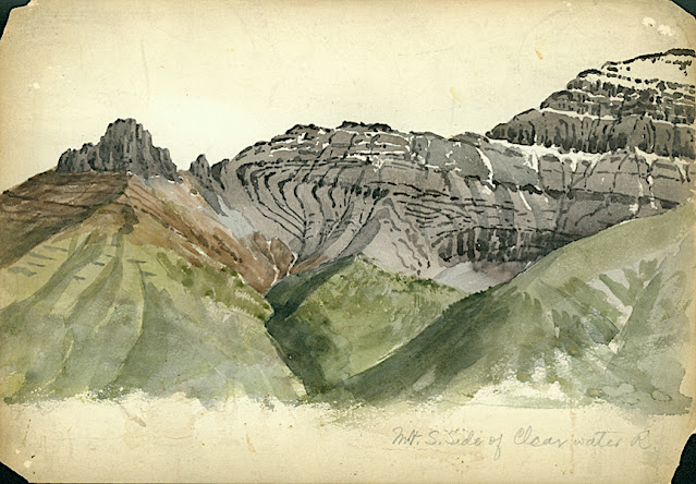
CLYDE PEAK PAINTED BY ARTHUR P. COLEMAN


ARTHUR P. COLEMAN (1852-1939), Clyde Peak (2,624 m - 8,610 f) United States of America (Montana)  In Mountain South Clide, watercolor on paper, 1895 A.P Coleman Funds.


ARTHUR P. COLEMAN (1852-1939)
Clyde Peak (2,624 m - 8,610 ft)
United States of America (Montana)

In Mountain South Clide, watercolor on paper, 1895 A.P Coleman Funds.


The mountain
Clyde Peak 2,624 m- is an 8,610 ft) is  located in Glacier National Park in the U.S. state of Montana. The mountain straddles the border shared by Flathead County and Glacier County. It is situated on the Continental Divide so precipitation runoff from the west side of the mountain drains into Thompson Creek which is part of the Middle Fork Flathead Riverwatershed, and the east side drains into headwaters of Red Eagle Creek, which flows to Red Eagle Lake, thence Saint Mary Lake. It is set in the Lewis Range, and the nearest higher neighbor is Mount Logan 1.44 mile to the northwest. Topographic relief is significant as the southwest aspect rises approximately 4,000 feet (1,220 meters) in one mile.
The mountain's name commemorates Norman Clyde (1885–1972), who made the first ascent of this peak on July 23, 1923.  Clyde is credited with 130 first ascents, most of which were in the Sierra Nevada of California.[ In 1923 he spent 36 days in Glacier National Park, Montana, where he climbed 36 mountains, including 11 first ascents.


The painter
Arthur Philemon Coleman was a Canadian a geologist, professor, minerals prospector, artist, Rockies explorer, backwoods canoeist, world traveller, scientist, popular lecturer, museum administrator, memoirist and... one of Canada’s most beloved scientist.
Arthur Coleman is a fine example of that rare bird, a polished amateur artist whose drawings and paintings stand comfortably beside those of many professionals. He was active during the time when sketching and painting was ceding to photography the task of recording the visible world. Although he was also a photographer, painting was, for him, both a poetic and a descriptive pursuit, a way of wrapping an artistic expression around a phenomenon he was interested in or moved by. Thus motivated, Coleman's paintings give much joy and command a good deal of respect. The more surprising, perhaps given that he used to introduced himself more as a geologist than a painter.
Coleman travelled throughout the United States for professional conferences as well as geological field work. He visited many of the major American mountain ranges including: the American Cordillera Mountains (Washington, Oregon and California); the Sierra Nevada Mountains (California and Nevada); Yellowstone National Park (Wyoming, Montana and Idaho); and the Appalachian Mountains (eastern United States). Pleistocene glaciation had extended in Northern Europe as far south as Berlin and London and covered an area of two million square miles. Coleman also visited such countries as India, Australia, Brazil, Argentina, Scandinavia, Bolivia, New Zealand, South Africa and Uruguay. In his final years he made two expeditions to the Andes in Colombia, to mountains in Southern Mexico and to two mountains in Central America. He achieved the first ascent of Castle Mountain in 1884, and in 1907, he was the first white man to attempt to climb Mount Robson. He made a total of eight exploratory trips to the Canadian Rockies, wholly four of them looking for the mythical giants of Hooker and Brown.
From 1901 to 1922, he was a Professor of Geology at the University of Toronto and was Dean of the Faculty of Arts from 1919 to 1922. From 1931 to 1934, he was a geologist with the Department of Mines of the Government of Ontario. He was elected a Fellow of the Royal Society of Canada in 1900 and was its President in 1921. In 1929, he was appointed Honorary Vice-President of the Royal Canadian Geographical Society.
"Mount Coleman" and "Coleman Glacier" in Banff National Park is named in his honor. He was awarded the Penrose Medal in 1936.
He planned to climb "his" mountain, "Mount Coleman"'in the Albertan Rockies, and had also prepared a trip to British Guiana, but death intervened.
He was author of:
- Reports on the Economic Geology of Ontario (1903)
- Lake Ojibway; Last of the Great Glacial Lakes (1909)
- The Canadian Rockies: New and Old Trails (1911)
- Ice Ages, Recent and Ancient (1926), and was co-author of Elementary Geology (1922).
- The Last Million Years (1941) edited by George F. Kay

 
___________________________________________
2021 - Wandering Vertexes...
by Francis Rousseau