google.com, pub-0288379932320714, DIRECT, f08c47fec0942fa0 GRAVIR LES MONTAGNES... EN PEINTURE: PENNINES ALPS
Showing posts with label PENNINES ALPS. Show all posts

Friday, December 1, 2023

BREITHORN  PEINT PAR  BLANCHE BERTHOUD

BLANCHE BERTHOUD d (1864 -1938) Breithorn (4,165 m-13,664 ft) Suisse-Italie   In Breithorn, huile sur carton, 25 x 33cm, 1920, Collection privée
 

BLANCHE BERTHOUD  (1864 -1938)
Breithorn (4,165 m-13,664 ft)
Suisse-Italie

In Breithorn, huile sur carton, 25 x 33cm, 1920, Collection privée


La montagne
Le Breithorn (4,165 m) est une montagne du massif des Alpes pennines, à la frontière entre la Suisse (canton du Valais) et l'Italie (Vallée d'Aoste). Le Breithorn possède cinq sommets principaux : le Breithorn occidental (4 163 ou 4 165 m) ; le Breithorn central (4 156 ou 4 160 m) ; le Breithorn oriental (4 138 ou 4 141 m) ; le Breithornzwillinge (4 106 m) ; la Roche Noire (4 074 ou 4 075 m).
La première ascension du Breithorn a été réalisée le 13 août 1813 par Henry Maynard avec Jean-Marie Couttet, Jean Gras, Jean-Baptiste et Jean-Jacques Érin.
Actuellement le Breithorn est considéré comme le 4 000 le plus facile des Alpes car un téléphérique amène les alpinistes au Petit Cervin, à 3 820 m d'altitude.

La peintre
Blanche Berthoud est une artiste peintre suisse de la région de Neufchâtel (Suisse) qui a été très active tout au long de la première moitié du 20e siècle. Elle fait partie de la Société romande des femmes peintres fondée par la peintre Jeanne Lombard (1865-1945) qui défend très farouchement les femmes peintres montagnardes, un monde souvent réservé aux hommes. Elle a réalisé plusieurs peintures et aquarelles du Breithorn, dont l'une a été acquise par le Musée d'Art et d'Histoire de Neufchâtel.

______________________________________

2023 - Gravir les montagnes en peinture
Un blog de Francis Rousseau


Sunday, April 23, 2023

LE MONT ROSE PHOTOGRAPHIÉ EN AUTOCHROME PAR ALBERT LÉON


AUTOCHROME LUMIERE AUGUSTE LÉON (1857-1942) Mont Rose- Pointe Dufour (4,664 m) Suisse - Italie  In Le mont Rose et le glacier du Gorner, Suisse, Autochrome Lumière, 1912, Musée Départemental Albert Kahn
 
 
AUTOCHROME 
AUGUSTE LÉON (1857-1942)
Mont Rose- Pointe Dufour (4,664 m)
Suisse - Italie

In Le mont Rose et le glacier du Gorner, Suisse, Autochrome Lumière, 1912, 
Musée Départemental Albert Kahn


La montagne
Le mont Rose (4 634 m), ou plus récemment massif du Mont-Rose -  en titsch gressonard, Gletscher ou Glescher, littéralement « montagne glacée » ou « glacier » , en italien, Monte Rosa —, situé à la frontière entre la Suisse et l'Italie, est le deuxième plus haut massif des Alpes après celui du Mont-Blanc. Son point culminant, la pointe Dufour, à 4 634 m est le quatrième plus haut sommet des Alpes et le plus haut de Suisse.  Au sommet de la Signalkuppe est situé le plus haut bâtiment et refuge d'Europe, la cabane Reine-Marguerite, à 4 559 mètres. S'y trouvent aussi un relais météorologique et un centre de recherche sur les pathologies liées à l'altitude. Les accès les plus faciles aux sommets du mont Rose se font de Gressoney-La-Trinité et d'Alagna Valsesia. Des habitants de ces deux vallées furent les premiers à faire l'ascension de cimes qui portent désormais leur nom en leur honneur. C'est le cas de Giovanni Gnifetti, curé d'Alagna, avec la pointe Gnifetti.  Le mont Rose est équipé d'un refuge innovant et à l'architecture spectaculaire, la cabane du Mont-Rose mise en service en 2010. Cette construction se distingue par son degré d'autonomie énergétique et sa capacité à respecter l'environnement. Elle est constituée d'un bâtiment sur cinq niveaux dont trois sont situés le long d'une façade inclinée de 80 m2 qui récupère la chaleur solaire. Le projet a été élaboré par l’École polytechnique fédérale de Zurich en collaboration avec le Club alpin suisse, l’université de Lucerne et le Laboratoire fédéral d'essai des matériaux et de recherche


Le procédé photographique
Auguste Léon fut un photographe français membre de l'équipe des "Archives de la planète" d'Albert Kahn 
L'Autochrome Lumière est un des premiers procédés de photographie couleur. Breveté en 1903 par les frères Lumière en France et commercialisé pour la première fois en 1907, c'était le principal procédé de photographie couleur utilisé avant l'avènement du film couleur négatif au milieu des années 1930.
Entre 1909 et 1931, une collection de 72 000 photographies autochromes, documentant la vie à l'époque dans 50 pays à travers le monde, a été créée par le banquier français Albert Kahn. La collection, l'une des plus importantes du genre au monde, est conservée au musée Albert Kahn à la périphérie de Paris. Une nouvelle compilation d'images de la collection Albert Kahn a été publiée en 2008. Plusieurs images de la collection Albert Kahn ont déjà été publiées dans ce blog.
La National Geographic Society a largement utilisé les autochromes et autres plaques d'écran couleur en mosaïque pendant plus de vingt ans. 15 000 plaques autochromes originales sont encore conservées dans les archives de la Société.
Dans l'immense collection d'œuvres du photographe pictorialiste américain Arnold Genthe de la Bibliothèque du Congrès des États-Unis, 384 de ses plaques autochromes figuraient parmi les collections en 1955. De nombreux photographes l'ont également utilisé, comme ici, de manière anonyme.


_________________________________________

2023 - Wandering Vertexes ....
Errant au-dessus des Sommets Silencieux...
Un blog de Francis Rousseau

Wednesday, April 6, 2022

THE DOM AND THE TÄSCHORN PAINTED BY W. F. BURGER

WILHELM FRIEDRICH BURGER (1882 -1964 ) The Dom (4,545 m (14,911 ft) The Täschhorn (4,491 m -14,734 ft) Switzerland  In The Dom and Täschhorn above Zermatt, watercolour, 30.5 x 37.5 cm. Courtesy John Mitchell Fine Arts London

WILHELM FRIEDRICH BURGER (1882 -1964)
The Dom (4,545 m (14,911 ft)
The Täschhorn (4,491 m -14,734 ft)
Switzerland

In The Dom and Täschhorn above Zermatt, watercolour, 30.5 x 37.5 cm.
Courtesy John Mitchell Fine Arts London

 
The mountains
The Dom (4 ,545 m  -14,911 ft)  is a mountain of the Pennine Alps, located between Randa and Saas-Fee in the canton of Valais in Switzerland. It is the seventh highest summit in the Alps, overall.  Based on prominence, it can be regarded as the third highest mountain in the Alps, and the second highest in Switzerland, after Monte Rosa. The Dom is the main summit of the Mischabel group (German: Mischabelhörner), which is the highest massif lying entirely in Switzerland. The Dom is noteworthy for its 'normal route' of ascent having the greatest vertical height gain of all the alpine 4000 metre peaks, and none of that route's 3,100 metres of height can be achieved using mechanical means. Although Dom is a German cognate for 'dome', it can also mean 'cathedral' and the mountain is named after Canon Berchtold of Sitten cathedral, the first person to survey the vicinity. The former name Mischabel comes from an ancient German dialect term for pitchfork, as the highest peaks of the massif stand close to each other.
The Täschhorn (4,491 m - 14,734 ft) is  lying south of the Dom within the Mischabel range.  Täschorn is a little lower than Dom but more difficult to access because there is mandatory rock climbing. Täschorn is a 3 sides pyramid.  East face is above Saas Fee, W face is above Täsch (last village before Zermatt), and huge South face is above Täschalp (Ottavan).  Each side belongs a glacier: on Täsch side is Kingletscher, on Ottavan side is Weingartengletscher, on Saas side is Feegletscher. The first ascent of the mountain was by John Llewelyn Davies and J. W. Hayward with guides Stefan and Johann Zumtaugwald and Peter-Josef Summermatter on 30 July 1862. The normal route is on the SE ridge starting from Mischabeljoch. To join the Mischabel pass, it's possible to come from either Saas Fee side or Täsch side.

 
The painter
Wilhelm, or Willy, Burger is nowadays widely recognized as one of the leading graphic artists of his time. His lithograph posters such as, Jungfraubahn. Station Jungfrau: Joch 3457m. Aletschgletscher, 1914 and St. Moritz, 1912are far better known – and more costly – than his oil paintings. However, he was first and foremost a painter by training who apprenticed in Zurich before leaving for Philadelphia and New York in 1908. He returned to Switzerland in 1913 where he set up a studio in Rüschlikon on the west shore of Lake Zürich from where he would travel throughout the Alps, the Mediterranean and as far afield as Egypt for his commissions. Although Burger cannot be categorized as a Symbolist in the strictest sense, his palette, his penchant for jagged outlines and his ethereal skies owe much to Ferdinand Hodler, the leading Swiss painter of the late nineteenth century. Hovering between Realism and Symbolism in style, this late afternoon view over the Zürichsee from the edge of the lake at Rüschlikon is an overt homage to Hodler who painted nearly 150 pictures of the Swiss lakes, many of them in a similar, panoramic format. Burger went so far as to sign his picture with a more spidery signature than usual – a pastiche of Hodler’s.
From 1901 onwards, Hodler began to concentrate on a series of acclaimed visions of Lac Léman (Geneva) in which he delineated horizontal bands of differing colours and tone. As he developed the theme of receding lines across the lake, or ‘parallelism’, as he called it, Mont Blanc and its surrounding peaks were introduced into the background. Hodler died in 1918 but in these late paintings he sought to express his concept of unité – the idea that there was a fundamental order to the universe and the artist’s role was to reveal it.

____________________________________
2022 - Wandering Vertexes...
by Francis Rousseau

Wednesday, March 16, 2022

THE SIMPLON PASS BY ANONYMOUS FRENCH PAINTER

19TH CENTURY' FRENCH SCHOOL OF PAINTING Col du Simplon (2,005 m - 6,578 ft) Switzerland  In  "Le passage des Alpes par l'armée napoléonienne",   Huile sur toile, non rentoilée, ca. 1806,   64,5 x 77 cm  Private collection

 ANONYMOUS FRENCH PAINTER
Col du Simplon (2,005 m - 6,578 ft)
Switzerland

In  "Le passage des Alpes par l'armée napoléonienne",   Huile sur toile, non rentoilée, ca. 1806,            64,5 x 77 cm  Private collection  

 
About the painting
This historical painting tells how and above all where the army of Napoleon 1st crossed the Alps to enter Italy, at the Simplon Pass (Col du Simplon). The road was built between 1801 and 1805 by the engineer Nicolas Céard, on the orders of Napoleon Bonaparte who wanted to open a passage for his artillery (described above); the cost was more than 8 million francs.  It was also Napoleon who, on February 21, 1801, without even consulting the canons of Saint-Bernard, decided to create a hospice in every way similar to that of the Col du Grand-Saint-Bernard, of which he had a lot appreciated the usefulness.  When Napoleon fell, only the first floor had been built. The building remained as it was until the mid-1820s, when work resumed and was completed in 1831.

The mountain pass
The Col du Simplon (2,005 m - 6,578 ft) (Simplon Pass in english) is a high mountain pass between the Pennine Alps and the Lepontine Alps in Switzerland. It connects Brig in the canton of Valais with Domodossola in Piedmont (Italy). The pass itself and the villages on each side of it, such as Gondo, are in Switzerland. The Simplon Tunnel was built beneath the vicinity of the pass in the early 20th century to carry rail traffic between the two countries.
The lowest point of the col (pass) and the lowest point on the watershed between the basins of the Rhone and the Po in Switzerland lies in marshland about 500 m - 1,640 ft west of the Simplon Pass settlement at an altitude of 1,994 m - 6,542 ft.
Rotelsee is a lake located near the pass at an elevation of 2,028 m (6,654 ft).
There are several great peaks around that can be climbed directly from the pass. These include Wasenhorn, Hubschhorn, Breithorn (Simplon), and Monte Leone.

The French school of painting in the 19th century
This term designates artworks produced in 19th-century France that reflects the teachings of the École des Beaux-Arts, the Parisian state-sponsored art academy.  Prioritizing draftsmanship over painting, the school taught students to employ fine line work and soft, blended shading in their drawings. Jean-Auguste-Dominique Ingres’s drawings, epitomize the Academic style, which is characterized by close attention to detail, near-invisible brushstrokes, and an emphasis on realistic modeling and shading. Academic painters often depicted scenes from history, literature, the Bible, or classical mythology, although this style can also be seen in pastoral scenes.

_______________________________

2022 - Wandering Vertexes...
by Francis Rousseau

Saturday, March 12, 2022

LE GRAND COMBIN PAINTED BY GUSTAVE DORÉ

GUSTAVE DORÉ (1832-1883) Le Grand Combin (4,314 m- 14, 154ft) Switzerland  In Le Grand Combin, Suisse romande, Oil on panel,  26 x 35 cm. Private collection (Christies)

GUSTAVE DORÉ (1832-1883)
Le Grand Combin (4,314 m- 14, 154ft)
Switzerland

In Le Grand Combin, Suisse romande, Oil on panel,  26 x 35 cm. Private collection (Christies)

The mountain
The Grand Combin is a mountain massif in the western Pennine Alps in Switzerland. With its 4,314 metres (14,154 ft) highest summit, the Combin de Grafeneire, it is one of the highest peaks in the Alps and the second most prominent of its range. The Grand Combin is also a large glaciated massif consisting of several summits, among which three are above 4000 metres:
- Combin de Grafeneire (4,314 m -14,154 ft),
- Combin de Valsorey (4,183 m -13,724 ft),
- Combin de la Tsessette (4,134 m -13,563 ft).
The massif of the Grand Combin lies south of Verbier between the Val d'Entremont (west) and Val de Bagnes (west). The north-western facing side of Grand Combin is entirely covered by eternal snows and glaciers which are prone to serac falls. The southern and eastern walls are more steep and thus exempt of snow.
The topography of the Grand Combin is intricate. Between the Val d'Entremont and the Val de Bagnes are two high ridges, nearly parallel to each other and to those valleys, which both diverge from a short transverse ridge of great height. The southern end of the space enclosed between these three ridges is an elevated plateau of great extent, where the snows accumulate and feed the Corbassière Glacier which descends thence for about ten kilometers to the north. The glacier is surrounded by the peaks of Petit Combin, Combin de Corbassière and Combin de Boveire on the west, Grand Tavé and Tournelon Blanc on the east. Smaller glaciers lie on the external flanks such as Boveire and Mont Durand Glacier.
The Grand Combin, which yields in height to only a few European mountains, was long one of the least known of Alpine summits. The first to commence the exploration of the great massif which separates the Val de Bagnes from the Val d'Entremont was Gottlieb Samuel Studer, of Berne, who on August 14, 1851 reached for the first time the summit of the Combin de Corbassière with the guide Joseph-Benjamin Fellay, and has published an account of that and a subsequent excursion in Bergund Gletscher-Fahrten. He was followed in that ascent five years later by W. and C. E. Mathews, and in 1857, William Mathews anticipated Studer in the ascent of the second peak of the Grand Combin.
The first four expeditions on Grand Combin reached only the minor summit east of Grand Combin (Aiguille du Croissant). The first one was made by mountain guides from the valley (Maurice Fellay and Jouvence Bruchez) on July 20, 1857. The first complete ascent of Grand Combin was finally made on July 30, 1859 by Charles Sainte-Claire Deville with Daniel, Emmanuel and Gaspard Balleys, and Basile Dorsaz.
The Grand Combin de Valsorey on the west was reached for the first time on 16 September 1872 by J. H. Isler and J. Gillioz. They climbed the south south face above the Plateau du Couloir. The itinerary on the south-east ridge was opened on 10 September 1891 by O. Glynne Jones, A.Bovier and P. Gaspoz.
The "Penitents", those reliefs of ice that one see rising on the surface of the glacier of the Grand Combin, in this 1787 painting, have all disappeared at the beginning of 21th century, because of global warming...


The painter
Paul-Gustave-Louis-Christophe Doré said Gustave Doré, born January 6, 1832 in Strasbourg and died January 23, 1883 in Paris in his house in the rue Saint-Dominique, is an illustrator, writer, cartoonist, painter and French sculptor. It has been internationally recognized in his lifetime.
In 1851, two albums Three artists misunderstood and unhappy and Des-approval for a pleasure trip are published at Aubert. Freed from the inspiration of Rudolf Töppfer and compliance executives, Gustave Doré performs freely arranged vignettes with several dimensions. The plurality of page composition, its innovations and graphic variants are deployed mainly in Des-approval for a pleasure trip. His technique uses the lithographic pencil, drawing directly on the stone.
Paul Lafon, writer and editor, he had met with Philipon, agreed to his request to illustrate the works of Rabelais. In 1854, the book is published by Bry with 99 vignettes and 14 inset plates engraved on wood. This affordable edition with low printing quality and modest size (large octavo) is not up to the high ambitions of Gustave Doré. In 1854 and 1873 shows two versions of "Rabelais Works" and in 1855: The Hundred Tales of comical by Honoré de Balzac.
In 1856 he illustrates with a painter's hand, The Wandering Jew, a poem set to music by Pierre Dupont, a work break in his artistic career and in the history of the woodcut. Abandoning copper engraving usually privileged, Gustave Doré chooses the color of wood technical (interpretation etching). Doré formed its own school burners. Each plank of the work, with a short caption end of the poem is a work of painting. The large format of the book allows the transition to movies folio. The image is independent of the text. This work is having great success with the public.
Gustave Doré wants to deploy his talent in illustration of the great works of literature, with contempt observed towards caricature and drawing current. It will list the thirty masterpieces in the epic, comic or tragic his ideal library wishing illustrate them in the same format as the Wandering Jew, Dante's Inferno, the Tales by Perrault, Don Quixote, Homer, Virgil, Aristotle, Milton (The lost paradise) or Shakespeare ... The publishers refuse to perform these luxury publications of too much cost. Gustave Doré should self-publish the works of Dante in 1861. The critical and popular success hails striking prints on the text. A critic will assert that: "The author is crushed by the designer. More than Dante illustrated by Doré, Doré is illustrated by Dante. "
In the 1860s, he illustrated the Bible.
He attended high society and expands his pictorial activities it consists of large paintings like Dante and Virgil in the ninth circle of Hell (1861 - 311 × 428 cm - Musée de Brou), The Enigma (Musée d'Orsay ) or the Christ leaving court (1867-1872 - 600 × 900 cm² Museum of modern and Contemporary Art of Strasbourg).
According to Ray Harryhausen, famous designer of special effects, multiplying together drawings and illustrations of all kinds (fantastic, portraits-loads), its reputation extends to Europe, he met a huge success in England with the Doré Gallery that opened in London in 1869. In 1875, the figure of Samuel Coleridge's poem The Rime of the Ancient Mariner (Lament of the Ancient Mariner) published in London by Golden Gallery is one of his greatest masterpieces.
His art of composition culminated in London, a Pilgrimage by Blanchard Jerrold, true story about the London of the late nineteenth century when all classes are present, inspiration is particularly striking in the description of the London slums.
He died of a heart attack at age 51 on January 23, 1883, leaving an impressive work of more than ten thousand pieces, which will have later a strong influence on many illustrators. His friend Ferdinand Foch organizes the funeral at St. Clotilde, burial at Père Lachaise and a farewell meal at 73 rue Saint-Dominique

_______________________________

2022 - Wandering Vertexes...
by Francis Rousseau
Tuesday, August 4, 2020

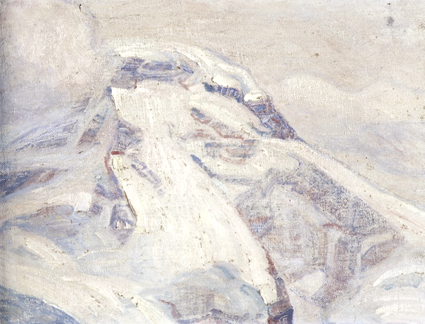
THE BREITHORN PAINTED BY JOHN J. REDMOND


JOHN J. REDMOND (1856-1929)
The Breithorn (4,165 m -13,664 ft) 
Switzerland - Italy border

In  Sunset on the Breithorn from Mürren, Bernese Oberland, Switzerland, oil on canvas, 
Courtesy John Mitchell Gallery, London 

The mountain
The Breithorn (4,165 m -13,664 ft) which means "broad horn" in german - is a mountain range of the Pennine Alps as well as its highest peak (also called Breithorn Western Summit). The Breithorn is located on the border between Switzerland and Italy. It lies on the main chain of the Alps, approximately halfway between the Matterhorn and Monte Rosa and east of the Theodul Pass. Most of the massif is glaciated and includes several subsidiary peaks, all located east of the main summit: the Western summit (4, 165m), the Middle summit (4,159m), the Eastern Breithorn-twin also called The Gendarm (4,106m), the Roccia Nera (Schwarzfluh) (4,075m). The main summit is sometimes distinguished by the name Western Breithorn (German: Breithorn (Westgipfel), Italian: Breithorn Occidentale). The nearest settlements are Zermatt (Valais) and St-Jacques (Aosta Valley).
The Breithorn was first climbed in 1813 by Henry Maynard (climber), Joseph-Marie Couttet, Jean Gras, Jean-Baptiste Erin and Jean-Jacques Erin.

The painter
John J. Redmond, was an american painter, active in late XIX and early XXth c. He belongs to the american impresssionism. His works were regularly exhibited in USA especially in Boston between 1888and 1909.
Born in Salem (Mass) he died in Switzerland.

Tuesday, July 2, 2019

MONTE FASCE PAINTED BY RICHARD PARKES BONINGTON


RICHARD PARKES BONINGTON (1802-1828) 
Monte Fasce (834 m - 2,736 ft)
Italy 

In  Boccadasse, Genoa with Monte Fasce in the Background , The Fitzwilliam Museum 

The mountain 
Monte Fasce (834 m - 2,736 ft) or Mount Fascie in the papers of the Military Geographical Institute, is one of the major hills of the city of Genoa. It is a mountain in the Ligurian Apennines and is part of the urban park of Monte Fasce and Monte Moro.
It rises behind the quarters of the eastern city of Quarto dei Mille, Quinto al Mare and Nervi, and protects them from the north wind. 
Nowadays, it is home to numerous television, radio, private and state repeaters. 
On the highest point is an iron cross 14 meters high, heir to the first wooden cross that had been placed around the year 1900. In the wind storm of 10/29/2018 the cross was torn down.
The nearby Prati di Fascia are traditionally a place for outings of the Genoese. From this height you can enjoy an almost total view of the city and on clear days you can admire Corsica, the island of Elba, the island of Palmaria, the Apuan Alps, the Maritime Alps, the Monviso, the Pennine Alps ( in particular the Matterhorn and the Monte Rosa) and the Lepontine Alps.
The Prati di Fascia can be reached along the SP 67 "del Monte Fasce", which joins the Genoese district of Apparizione with Uscio and from which there is a short dirt road that reaches the top of the mountain.

The painter 
Richard Parkes Bonington  was an English Romantic landscape painter, who moved to France at the age of 14 and can also be considered as a French artist, and an intermediary bringing aspects of English style to France.  Becoming, after his very early death, one of the most influential British artists of his time, the facility of his style was inspired by the old masters, yet was entirely modern in its application. His landscapes were mostly of coastal scenes, with a low horizon and large sky, showing a brilliant handling of light and atmosphere. He also painted small historical cabinet paintings in a freely-handled version of the troubadour style.
Eugène Delacroix paid tribute to Bonington's work in a letter to Théophile Thoré in 1861. It reads, in part:
" When I met him for the first time, I too was very young and was making studies in the Louvre: this was around 1816 or 1817... Already in this genre (watercolor), which was an English novelty at that time, he had an astonishing ability... To my mind, one can find in other modern artists qualities of strength and of precision in rendering that are superior to those in Bonington's pictures, but no one in this modern school, and perhaps even before, has possessed that lightness of touch which, especially in watercolours, makes his works a type of diamond which flatters and ravishes the eye, independently of any subject and any imitation."

To Laurence Binyon however, "Bonington's extraordinary technical gift was also his enemy. There is none of the interest of struggle in his painting."
Bonington had a number of close followers, such as Roqueplan and Isabey in France, and Thomas Shotter Boys, James Holland, William Callow and John Scarlett Davis in England. In addition, there were many copies and forgeries of his work made in the period immediately after his death.
The Wallace Collection has an especially large group of 35 works, representing both his landscapes and history paintings.

___________________________________________
2019 - Wandering Vertexes...
by Francis Rousseau 

Sunday, June 23, 2019

THE WEISSHORN PAINTED BY FERDINAND HODLER


FERDINAND HODLER (1853-1918),
Weisshorn (4,506 m  - 14,783 ft)
Switzerland

In Weisshorn of Montana,  oil on canvas, 1915

The mountain 
The Weisshorn  (4,506 m  - 14,783 ft), meaning the white peak, is a major peak of the Swiss Alps,  part of the Pennine Alps and  located between the valleys of Anniviers and Zermatt in the canton of Valais. In the latter valley, the Weisshorn is one of the many 4000ers surrounding Zermatt, with Monte Rosa and the Matterhorn.
It is the culminating point on the north-south orientated chain separating the Val d'Anniviers to the west and the Mattertal to the east and enclosing the Turtmanntal to the north, the tripoint between these valleys being located just north of its main summit. The Weisshorn faces the slightly higher Dom across the Mattertal, with the village of Randa 3100 metres below these two summits. After the Dom, the Weisshorn is the second-highest Alpine summit situated completely out the main chain and fully within Switzerland. On both sides of the Weisshorn range, the water end up in the Rhone, through the Navissence (west) and the Vispa (east). The Weisshorn and the Dom are only two of the many 4000-metre peaks surrounding the region of Zermatt, along with the Zinalrothorn, the Dent Blanche, the Dent d'Hérens, the Matterhorn and, second highest in the Alps, Monte Rosa.
The Weisshorn has a pyramidal shape and its faces are separated by three ridges descending steeply from the summit. Two of these are nearly in a straight line, one running approximately north and the other south. The third ridge is nearly at right angles to these two, running almost due east. In the compartment between the northern and eastern spurs lies the Bis Glacier (Bisgletscher). It is connected with the summit by long and extremely steep slopes of snow. In the compartment between the eastern and southern spurs lies the Schali Glacier (Schaligletscher). Ranges of steep rocks rise round the whole basin of this glacier, except in one or two places where they are interrupted by couloirs of snow. Finally, on the western side the mountain presents one gigantic face of rocky precipice. This face rises above the Weisshorn Glacier (Glacier du Weisshorn) and the Moming Glacier. The northern spur forks out at a considerable distance below the summit into two branches enclosing the Turtmann Glacier. The eastern branch connects the mountain with the Bishorn (4,153 m), across the Weisshornjoch.
The Weisshorn was first climbed in 1861 from Randa by the Irish physicist John Tyndall, accompanied by the guides J.J. Bennen and Ulrich Wenger. Nowadays, the Weisshorn Hut is used on the normal route. The Weisshorn is considered by many mountaineers to be the most beautiful mountain in the Alps and Switzerland for its pyramidal shape and pure white slopes.


The painter
Ferdinand Hodler was one of the best-known Swiss painters of the 19th century. His early works were portraits, landscapes, and genre paintings in a realistic style. Later, he adopted a personal form of symbolism he called Parallelism.
In the last decade of the nineteenth century his work evolved to combine influences from several genres including Symbolism and Art Nouveau. In 1890 he completed Night, a work that marked Hodler's turn toward symbolist imagery. It depicts several recumbent figures, all of them relaxed in sleep except for an agitated man who is menaced by a figure shrouded in black, which Hodler intended as a symbol of death. Hodler developed a style he called "Parallelism" that emphasized the symmetry and rhythm he believed formed the basis of human society. In paintings such as The Chosen One, groupings of figures are symmetrically arranged in poses suggestive of ritual or dance.
Hodler painted number of large-scale historical paintings, often with patriotic themes. In 1897 he accepted a commission to paint a series of large frescoes for the Weapons Room of the Schweizerisches Landesmuseum in Zurich. The compositions he proposed, including The Battle of Marignan which depicted a battle that the Swiss lost, were controversial for their imagery and style, and Hodler was not permitted to execute the frescoes until 1900.
Hodler's work in his final phase took on an expressionist aspect with strongly coloured and geometrical figures. Landscapes were pared down to essentials, sometimes consisting of a jagged wedge of land between water and sky
_________________________________________
2019 - Wandering Vertexes...
Un blog de Francis Rousseau


Tuesday, April 2, 2019

MONTE BESSO PAINTED BY OTTO MÄLHY


OTTO MÄLHY (1869-1953) 
Monte Besso (3,667 m - 12, 034ft)
Switzerland

 In Monte Besso seen from Sorebois, Val d'Anniviers, Switzerland 
oil on canvas ( 88,5 x 72 cm) John  Mitchell Gallery, London 


The mountain 
Mount Besso (3,667 m - 12, 034ft) is a Swiss peak in the Pennine Alps valley. It is located on the edge of the Zinal valley.  The name Besso means 'twins' in the dialect of the Val d'Hérens and refers to the twin summits of the mountain.
The mountain is part of the so-called imperial crown , set of mountains that form a horseshoe: Les Diablons, the Bishorn (4,153 m), the Weisshorn (4,505 m), the Schalihorn (3,974 m), the Zinalrothorn (4,221 m), the Trifthorn (3,728 m), the Obergabelhorn (4,062 m), the Mont Durand (3,712 m), the Pointe de Zinal (3,790 m), the Dent Blanche (4,356 m), the Grand Cornier (3,961 m), the Pigne de la Lé (3.396 m), the Garde de Bordon (3.310 m), and at the center of this gigantic parable is Mount Besso (3.667 m).
The first ascent to the summit probably took place in 1862 by JB Epinay and J. Vianin. The normal ascent route to the summit starts from the Cabane du Grand Mountet. 

The painter 
 Otto Mähly was a Swiss artist who was born in 1869 in Basel. Otto Mähly's work has been offered at auction multiple times. Only one artwork sold; this was View of the Rigi, which realized $1,801 USD at Dobiaschofsky in 2017. The artist died in 1953.

___________________________________________
2019 - Wandering Vertexes...
by Francis Rousseau 

Tuesday, February 19, 2019

MONTE ROSA BY JEAN-FRANÇOIS ROFFIAEN


JEAN-FRANÇOIS ROFFIAEN ( 1820-1898) 
Pointe Dufour / Dufourspitze  (4,634 m - 7,103ft) 
Switzerland- Italy border  

In Sunrise on Monte Rosa seen from Riffelsee, Zermatt, oil on canvas  (72.5 x 118cm), 1871, Courtesy John Mitchell Gallery, London 

About the painting 
In 1845 Roffiaen saw two paintings by Alexandre Calame at the Salon de Bruxelles. He was so impressed by them that the young Belgian was awarded a place to train in his new mentor’s Geneva studio for six months. His style and subject matter remained close to Calame’s throughout his life, but he travelled further afield to the Mediterranean. Roffiaen’s work was admired and collected by the royal families of Europe and this magnificent dawn view of Monte Rosa is probably the prototype version for a large two-and a half metre canvas, dated 1875, now in the Brussels museum together with several other pictures by him.

The mountain 
The  Pointe Dufour (4,634 m - 7,103ft), in german Dufourspitze, is the highest peak of Monte Rosa, (Mont Rose) a huge ice-covered mountain massif in the Alps. Dufourspitze is the highest mountain peak of both Switzerland and the Pennine Alps and is also the second-highest mountain of the Alps and Europe outside the Caucasus. It is located between Switzerland (Canton of Valais) and Italy (Piedmont and Aosta Valley). Following a long series of attempts beginning in the early nineteenth century, Monte Rosa's summit, then still called Hцchste Spitze, was first reached on 1 August, the Swiss National celebration day, in 1855 from Zermatt by a party of eight climbers led by three guides: Matthдus and Johannes Zumtaugwald, Ulrich Lauener, Christopher and James Smyth, Charles Hudson, John Birkbeck and Edward Stephenson.
The name Pointe Dufour or Dufour Spitze  replaced the former name Höchste Spitze (English: Highest Peak) that was indicated on the Swiss maps before the Federal Council, on January 28, 1863, decided to rename the mountain in honor of Guillaume-Henri Dufour. Dufour was a Swiss engineer, topographer, co-founder of the Red Cross and army general who led the Sonderbund campaign. This decision followed the completion of the Dufour Map, a series of military topographical maps created under the command of Dufour.
The point just 80 m (260 ft) east of the Dufourspitze and only 2 metres lower, the Dunantspitze, was renamed in 2014 in honor of Henry Dunant, the main founder of the Red Cross.

The painter 
Jean François Xavier Roffiaen was a Belgian landscape painter who specialized in painting Alpine landscapes. He followed his artistic studies at the Academy of Brussels (1839–1842), notably under the famous vedutiste, François Bossuet (1789–1889) who was responsible for teaching him perspective and who was the authority on landscapes and city views.
The years 1850–1860 were those of Roffiaen's  greatest success, including numerous sales in Belgium, in Great Britain and in the United States, having works acquired by the Shah of Persia, by the Belgian and British royal houses, a study tour of Scotland commissioned by Queen Victoria, but which unfortunately never took place because of the sudden death of Albert, Prince Consort.  His painting, constructed according to indefinitely repeated formulae and each year becoming a little more tired, finished however by wearying the art chroniclers : « Critics of the press have often reproached him for the bias he shows in his painting. M Roffiaen has ignored them, he has continued to accumulate landscapes of Belgium, Scotland, Switzerland, Germany, Italy, what do I know, combing them without rest, using the same formula, making do with the same sky, the same trees, the same rocks, unconcerned by the latitudes, according to the taste of a special public, who buy all of that and pay him handsomely. Leave M. Roffiaen alone, gentlemen of the press, he paints his little nature scenes one demands of him and knows well the reason why. » 
(G. H., L’Organe de Namur et de la Province, 1874).
François Roffiaen is equally illustrious in the domain of natural sciences, to which Jules Colbeau (1823–1881) introduced him in his youth. While children the two companions already took delight in observing nature in the little property that Colbeau’s parents owned in the suburbs of Namur. Once adult, they took a journey together to Switzerland (1852) where they collected insects, butterflies and molluscs.

___________________________________________
2019 - Wandering Vertexes...
by Francis Rousseau 


Thursday, May 10, 2018

BREITHORN (2) PAINTED BY BLANCHE BERTHOUD

http://wanderingvertexes.blogspot.com


BLANCHE BERTHOUD (1864-1938)
The Breithorn (4,165 m -13,664 ft)
Switzerland - Italy border

In Alpenpartie mit Sicht auf das Breithorn, oil on canvas

The mountain 
The Breithorn  (4,165 m -13,664 ft) which means "broad horn" in german - is a mountain range of the Pennine Alps as well as its highest peak (also called Breithorn Western Summit). The Breithorn is located on the border between Switzerland and Italy. It lies on the main chain of the Alps, approximately halfway between the Matterhorn and Monte Rosa and east of the Theodul Pass. Most of the massif is glaciated and includes several subsidiary peaks, all located east of the main summit: the Western summit (4, 165m), the Middle summit (4,159m),  the Eastern Breithorn-twin also called The Gendarm (4,106m), the Roccia Nera (Schwarzfluh) (4,075m). The main summit is sometimes distinguished by the name Western Breithorn (German: Breithorn (Westgipfel), Italian: Breithorn Occidentale). The nearest settlements are Zermatt (Valais) and St-Jacques (Aosta Valley).
The Breithorn was first climbed in 1813 by Henry Maynard (climber)Joseph-Marie CouttetJean GrasJean-Baptiste Erin and Jean-Jacques Erin.

The painter 
Blanche Berthoud was a Swiss painter from the region Neufchatel (Switzerland) who was very active throughout the first half of the 20th century. She was part of the  Société romande des femmes peintres  (Romande Society of Women Painter) founded  by the painter Jeanne Lombard (1865-1945) who defended very fiercely mountain women painters, a world often reserved for men. She made several paintings and watercolors of the Breithorn, one of which was acquired by the Museum of Art and History of Neufchatel.


2018 - Wandering Vertexes...
by Francis Rousseau 


Monday, March 12, 2018

POINTE DUFOUR BY ADOLPHE BRAUN


 ADOLPHE BRAUN (1812-1877)
Pointe Dufour  / Dufour Spitze (4,634 m - 7,103ft) 
 Switzerland - Italy border 

1. In Le Mont Rose, 1860 
2. In  Le Mont Rose  between 1863 and 1865, Musée Condé Chantilly

The Mountain 
The  Pointe Dufour (4,634 m - 7,103ft) , in german Dufourspitze, is the highest peak of Monte Rosa, (Mont Rose) a huge ice-covered mountain massif in the Alps. Dufourspitze is the highest mountain peak of both Switzerland and the Pennine Alps and is also the second-highest mountain of the Alps and Europe outside the Caucasus. It is located between Switzerland (Canton of Valais) and Italy (Piedmont and Aosta Valley). Following a long series of attempts beginning in the early nineteenth century, Monte Rosa's summit, then still called Hцchste Spitze, was first reached on 1 August, the Swiss National celebration day, in 1855 from Zermatt by a party of eight climbers led by three guides: Matthдus and Johannes Zumtaugwald, Ulrich Lauener, Christopher and James Smyth, Charles Hudson, John Birkbeck and Edward Stephenson.
The name Pointe Dufouror Dufour Spitze  replaced the former name Höchste Spitze (English: Highest Peak) that was indicated on the Swiss maps before the Federal Council, on January 28, 1863, decided to rename the mountain in honor of Guillaume-Henri Dufour. Dufour was a Swiss engineer, topographer, co-founder of the Red Cross and army general who led the Sonderbund campaign. This decision followed the completion of the Dufour Map, a series of military topographical maps created under the command of Dufour.
The point just 80 m (260 ft) east of the Dufourspitze and only 2 metres lower, the Dunantspitze, was renamed in 2014 in honor of Henry Dunant, the main founder of the Red Cross.

The photographer
Adolphe Braun was a French photographer, best known for his floral still lifes, Parisian street scenes, and grand Alpine landscapes. One of the most influential French photographers of the 19th century, he used contemporary innovations in photographic reproduction to market his photographs worldwide. In his later years, he used photographic techniques to reproduce famous works of art, which helped advance the field of art history.
Photography historian Naomi Rosenblum described Braun's work as representative of the relationship between art and commercialism in the mid-19th century. His self-sustaining Mulhouse studio helped elevate photography from a craft to a full-scale business enterprise, producing thousands of unique images which were reproduced and marketed throughout Europe and North America.  Rosenblum also suggests that Braun's detailed reproductions of works of art in European museums brought these works to art students in North America, providing a major catalyst for the field of art history in the United States. Subsequent photographs focused on Alpine landscapes, especially lake scenes, and glacier scenes. Unlike many landscape photographers during this period, Braun liked to include people in his scenes. Photography historian Helmut Gernsheim suggested that Braun was one of the most skillful photographers of his era in rendering composition.  While not known as a portraitist, he did take portraits of several notable individuals, including Pope Pius IX, Franz Liszt, and the Countess of Castiglione, mistress of Napoleon III. Braun's work has been exhibited at the Metropolitan Museum of Art, the J. Paul Getty Museum, the George Eastman House, and the Musйe d'Orsay.
His photographs of Parisian street scenes and Alpine landscapes are frequently reproduced in works on the history of photography.


Monday, July 17, 2017

GRAND COMBIN BY JEAN-FRANÇOIS ALBANIS BEAUMONT


JEAN-FRANÇOIS ALBANIS  BEAUMONT (1753-1812)  
The Grand Combin (4,314 m- 14, 154ft) 
 Switzerland

In Le glacier du Combin de Valsorey - Voyage pittoresque aux Alpes pennines, 1787, aquatint

The mountain 
The Grand Combin is a mountain massif in the western Pennine Alps in Switzerland. With its 4,314 metres (14,154 ft) highest summit, the Combin de Grafeneire, it is one of the highest peaks in the Alps and the second most prominent of its range. The Grand Combin is also a large glaciated massif consisting of several summits, among which three are above 4000 metres:
- Combin de Grafeneire (4,314 m -14,154 ft),
- Combin de Valsorey  (4,183 m -13,724 ft),
- Combin de la Tsessette  (4,134 m -13,563 ft).
The massif of the Grand Combin lies south of Verbier between the Val d'Entremont (west) and Val de Bagnes (west). The north-western facing side of Grand Combin is entirely covered by eternal snows and glaciers which are prone to serac falls. The southern and eastern walls are more steep and thus exempt of snow.
The topography of the Grand Combin is intricate. Between the Val d'Entremont and the Val de Bagnes are two high ridges, nearly parallel to each other and to those valleys, which both diverge from a short transverse ridge of great height. The southern end of the space enclosed between these three ridges is an elevated plateau of great extent, where the snows accumulate and feed the Corbassière Glacier which descends thence for about ten kilometers to the north. The glacier is surrounded by the peaks of Petit Combin, Combin de Corbassière and Combin de Boveire on the west, Grand Tavé and Tournelon Blanc on the east. Smaller glaciers lie on the external flanks such as Boveire and Mont Durand Glacier.
The Grand Combin, which yields in height to only a few European mountains, was long one of the least known of Alpine summits. The first to commence the exploration of the great massif which separates the Val de Bagnes from the Val d'Entremont was Gottlieb Samuel Studer, of Berne, who on August 14, 1851 reached for the first time the summit of the Combin de Corbassière with the guide Joseph-Benjamin Fellay, and has published an account of that and a subsequent excursion in Bergund Gletscher-Fahrten. He was followed in that ascent five years later by W. and C. E. Mathews, and in 1857, William Mathews anticipated Studer in the ascent of the second peak of the Grand Combin.
The first four expeditions on Grand Combin reached only the minor summit east of Grand Combin (Aiguille du Croissant). The first one was made by mountain guides from the valley (Maurice Fellay and Jouvence Bruchez) on July 20, 1857. The first complete ascent of Grand Combin was finally made on July 30, 1859 by Charles Sainte-Claire Deville with Daniel, Emmanuel and Gaspard Balleys, and Basile Dorsaz.
The Grand Combin de Valsorey on the west was reached for the first time on 16 September 1872 by J. H. Isler and J. Gillioz. They climbed the south south face above the Plateau du Couloir. The itinerary on the south-east ridge was opened on 10 September 1891 by O. Glynne Jones, A.Bovier and P. Gaspoz.
The "Penitents", those reliefs of ice that one see rising on the surface of the glacier of the Grand Combin, in this 1787 painting, have all disappeared at the beginning of 21th century, because of global warming...

The painter
Sir  Jean-François Albanis Beaumont, draughtsman, aquatint engraver, and landscape painter, was born in Chambery in 1753, but naturalized in England.  He studied classics in Chambéry and when he was 17 years old went to Paris. He studied 4 years at the Royal College of Engineering of Mézières and received several commissions in the Bourbonnais.
Returning in 1775 to Chambéry, he designed the decorations for the celebrations of the marriage of Clotilde de France and Prince Charles-Emmanuel. Engineer Filippo Nicolis di Robilant encouraged him to work for king Victor Amadeus III, who placed him with the chief engineer of the county of Nice, where he took part in the important works underway in Port Lympia. He was inscribed on April 30, 1780, in the class of civil architects of the University of Turin.
He accompanied the Duke of Gloucester, William Frederick of Hanover in his Grand Tour (Germany, Italy, France and Switzerland), who subsequently entrusted him with the education of his children. He then settled in Britain and married an Englishwoman of Protestant religion.
In 1787 he began to publish his first works illustrated with his own drawings "Picturesque travel to the Pennine Alps", "Historical and picturesque journey of the County of Nice", "Journey through the Rhaetian Alps in 1786", "Selected views of antiquities And ports in the south of France "and" Travel through the Maritime Alps".
In 1796, his mission was completed and he could return to Savoie and settle near Genevawhere in 1798 he bought a small agricultural estate on the commune of Thônex with which he planned to enter the  trade of wool. He does not find the success expected and must soon resell everything and resume his work as geographer and traveler.
In 1800, he published "Journey in the Alps Lepontine from France to Italy" and then "Description of the Greek and Cote Alps" (1802 and 1806).
In 1810, he died at the monastery of Sixt of which he became the owner. He had resumed the exploitation of the iron mines, but he faced too many difficulties. He is buried on the spot.
The views of the towns and landscapes he drew are very sought after and give an idea of ​​the appearance of these places at the time.

Saturday, March 11, 2017

LYSKAMM PAINTED BY BLANCHE BERTHOUD


http://wanderingvertexes.blogspot.com

BLANCHE BERTHOUD (1864 -1938)
Lyskamm or Silberbast (4,527 m - 14,852 ft)
Switzerland - Italy border 

In blick auf den Liskamm, 1900

The mountain 
Lyskamm (4,527 m - 14,852 ft) which means literally "comb of the Lys", also known as Silberbast (literally "silver bast"), is a mountain in the Pennine Alps lying on the border between Switzerland and Italy. It consists of a five-kilometre-long ridge with two distinct peaks. The mountain has gained a reputation for seriousness because of the many cornices lying on the ridge and the frequent avalanches, thus leading to its nickname the Menschenfresser ("people eater"). Because of its modest prominence (376 m), Liskamm is sometimes considered to be part of the extended Monte Rosa group (in fact the Dufourspitze is only 107 metres higher). But visually Liskamm is a huge massif, composed of two summits: the Eastern Liskamm and the lower Western Liskamm, separated by a 1 kilometre (0.62 mi) long ridge, both lying on the border between the Swiss canton of Valais (north) and the Italian region of the Aosta Valley (south). The northern side of the mountain is an impressive 1,100 metres (3,600 ft) ice-covered wall, rising up from the Grenzgletscher. The gentler southern side rises only a few hundred metres above the glacier of the same name: Lysgletscher.

The painter 
Blanche Berthoud was a Swiss painter from the region of Neufchatel (Switzerland) who was very active throughout the first half of the 20th century. She was part of the Société romande des femmes peintres  (Romande Society of Women Painter) founded  by the painter Jeanne Lombard (1865-1945) who defended very fiercely mountain women painters, a world often reserved for men. She made several paintings and watercolors of the Breithorn, one of which was acquired by the Museum of Art and History of Neufchatel

2017 - Wandering Vertexes...
by Francis Rousseau 

Tuesday, November 22, 2016

GRAND GOLLIAT PAINTED BY GUSTAVE COURBET


GUSTAVE COURBET (1819-1877)
Grand Golliat (3,238m - 10, 623ft)
Italy - Switzerland border

In Le chalet dans la montagne, Suisse (Tour-de-Peilz, Vevey) vers 1874, oil on canvas, 
 The Pouchkine State  Museum of Fine Arts, Moscow

The mountain 
The Grand Golliat  (3,238m - 10, 623ft), also spelled Grand Golliaz is a mountain of the Pennine Alps, located between the Petit Col Ferret and the Great St. Bernard Pass. Is summit straddles the border between Switzerland and Italy, separating the Swiss canton of Valais from the Italian region of Aosta Valley. The name Golliat does not come from the Bible hero Goliath but from "Goilles" which are small lakes or water springs located on the Italian side of the mountain.
Huge bulwark made by two summits justified S-N: the Piccolo (3.234m) and the Grand Golliaz or Golliat;  the most important summit of the range between Mont Blanc and Velan-Combin Groups on the border ridge between Italy and Switzerland. Magnificent panoramic tower in the NW side of Val d'Aosta with a great round view even on Swiss giants. The bad quality rock doesn't allow fine climbing routes, the icy routes (N wall) are interesting but dangerous for the continuous rock falls in the channels. The SE side, ski-mountaneering route, requires well tidy snow.
The Grand Golliat is the southernmost mountain rising above 3,000 metres in Switzerland.
Source: 

The painter 
Jean Désiré Gustave Courbet was a French painter who led the Realist movement in 19th-century French painting. Committed to painting only what he could see, he rejected academic convention and the Romanticism of the previous generation of visual artists. His independence set an example that was important to later artists, such as the Impressionists and the Cubists. Courbet occupies an important place in 19th-century French painting as an innovator and as an artist willing to make bold social statements through his work.
Courbet's paintings of the late 1840s and early 1850s brought him his first recognition. They challenged convention by depicting unidealized peasants and workers, often on a grand scale traditionally reserved for paintings of religious or historical subjects. Courbet's subsequent paintings were mostly of a less overtly political character: landscapes, seascapes, hunting scenes, nudes and still lifes. He was imprisoned for six months in 1871 for his involvement with the Paris Commune, and lived in exile in Switzerland from 1873 until his death.
Courbet  painted a few mountains in his life : the Juras mountains around Ornans ( France) and a few  mountains in Switzerland during his exil; Like many painters of the 19th Century, Courbet didn't name the mountain he painted; he liked to give a description of the general atmosphere rather than  a precise geographical location. 
 "I am fifty years old and I have always lived in freedom; let me end my life free; when I am dead let this be said of me: 'He belonged to no school, to no church, to no institution, to no academy, least of all to any régime except the régime of liberty."


Wednesday, October 26, 2016

THE BREITHORN PAINTED BY BLANCHE BERTHOUD


BLANCHE BERTHOUD (1864 -1938) 
The Breithorn (4,165 m -13,664 ft)
Switzerland - Italy border

3 views in 1899 (oil on canvas) , 1906 (oil on canvas),

The mountain 
The Breithorn  (4,165 m -13,664 ft)  - which means "broad horn" in german - is a mountain range of the Pennine Alps as well as its highest peak (also called Breithorn Western Summit). The Breithorn is located on the border between Switzerland and Italy. It lies on the main chain of the Alps, approximately halfway between the Matterhorn and Monte Rosa and east of the Theodul Pass. Most of the massif is glaciated and includes several subsidiary peaks, all located east of the main summit: the Western summit (4, 165m), the Middle summit (4,159m),  the Eastern Breithorn-twin also called The Gendarm (4,106m), the Roccia Nera (Schwarzfluh) (4,075m). The main summit is sometimes distinguished by the name Western Breithorn (German: Breithorn (Westgipfel), Italian: Breithorn Occidentale). The nearest settlements are Zermatt (Valais) and St-Jacques (Aosta Valley).
Climbing 
The Breithorn was first climbed in 1813 by Henry Maynard (climber)Joseph-Marie CouttetJean GrasJean-Baptiste Erin and Jean-Jacques Erin.  East Breithorn was first climbed 16 August 1884 by J.Stafford Anderson. Central Breithorn was first climbed  19 July 1900 by E. Hahn.
Nowadays, the Breithorn is considered the most easily climbed 4,000 m Alpine peak. This is due to the Klein Matterhorn cable car which takes climbers to over 3,820 m (12,700 ft) from Zermatt for a starting point. The standard route (SSW flank) is from the Italian side of the mountain (the south side) and continues over a glacial plateau before climbing to the summit on a 35 degree snow slope. However, inexperienced mountaineers may run into severe difficulty if caution is not taken near cornices or in bad weather. For experienced climbers wanting more of a challenge, the half traverse of the Breithorn crest is another option.

The painter 
Blanche Berthoud was a Swiss painter from the region Neufchatel (Switzerland) who was very active throughout the first half of the 20th century. She was part of the  Société romande des femmes peintres  (Romande Society of Women Painter) founded  by the painter Jeanne Lombard (1865-1945) who defended very fiercely mountain women painters, a world often reserved for men. She made several paintings and watercolors of the Breithorn, one of which was acquired by the Museum of Art and History of Neufchatel.

2016 - Wandering Vertexes...
by Francis Rousseau