google.com, pub-0288379932320714, DIRECT, f08c47fec0942fa0 GRAVIR LES MONTAGNES... EN PEINTURE: Search results for Chile
Showing posts sorted by relevance for query Chile. Sort by date Show all posts

Saturday, October 29, 2016

PARINACOTA PAINTED BY RAMOS CATALAN

wanderingvertexes.blogspot.fr

RAMOS CATALAN (1888-1961)
 Parinacota  (6,348 m - 20,827ft)
Chile - Bolivia

From the series " Mountains of Chile" possibly volcano Parinacota seen from the south 

The Mountain 
Parinacota (6,348 m- 20,827ft) or Parina Quta or Parinaquta is a massive dormant stratovolcano on the border of Chile and Bolivia. Cerros de Payachata, means twin mountains and there are only two peaks in the range. It is usually counted as a sub-range in the Cordillera Occidental. Parinacota is slightly higher than its twin brother/sister Pomerape (6,282m). Both volcanoes are right on the Chilean - Bolivian border and can be climbed from either side. Their closest neighbor is Bolivia's highest mountain Sajama (6,542m) which isn't more than 20km away. Parinacota is located in the extreme NE of Chile, where the country borders to Bolivia. The closest really large city is La Paz, the capital of Bolivia, which is about 300km and five hours away. Arica, in Chile is at the Pacific coast and is about 180 km far (and almost 5000 vertical meters!).
It is part of the Payachata volcanic group. The other major edifice in that group is the Pleistocene peak of Pomerape.  Parinacota's last eruptive phase has been dated using the helium surface exposure technique, which ties the eruption to 290AD ± 300 years.
One of the most dramatic eruptive events in the volcano's past was 8,000 years ago, when a major collapse of the edifice produced a 6 kmі (1.44 cubic miles) debris avalanche, which blocked nearby drainage patterns, creating Chungara Lake.
The volcano and Pomerape straddle the border between Sajama National Park (Bolivia) and Lauca National Park (Chile).
Climbing
Parinacota was first climbed in 1928 by Joseph Prem and Carlos Terán.
Climbing the volcano is  alpine F grade, on a snow/rubble slope of about 35 degrees. A camp can be established at 5,300 m at the saddle between Parinacota and Pomerape. Depending on the season, the main difficulty can be a snow formation called penitentes which make the ascent physically difficult or impossible. It is attempted by about one party per week in the season. If needed, guides and transport can be hired from Sajama village, 27 km away on the Bolivian side of the mountain.
The main climbing season is from late June to mid September. This is the winter season of the southern hemisphere. It's also the time with the lowest precipitation and most stable weather. Between May and September there's almost no risk of any rain or snow at all. 

The painter 
Benito Ramos Catalán (1888-1961) was a chilean  painter who used to sign "Ramos Catalan". Known for his marines and landscapes of the Andes and Chile, particularly his mountains paintings. Most of them have the same title:  "Mountains of Chile" or  "Mountains landscapes of Andes", making quite difficult to know which mountain was exactly depicted, in a country which has quite a lot of summits ! To add to the difficulty, he used to paint the most famous mountains of his country under very unusual angles or with proportions that do not correspond exactly to their real size... making even more difficult to recognize and identify them for experts ! That is why today, 55 years after his death, some of these mountains paintings are not clearly identified and presented, in the public sales, as 'possibly' a particular summit of Chile or Andes...
His works are in many Chilean institutions like  Viña del Mar Fine Art  Museum, O'Higginiano Fine Art Museum in Talca, Valparaiso Fine Art Museum, and Navy Schools in Valparaiso.

2016 - WanderingVertexes
Un blog de Francis Rousseau

Sunday, March 1, 2020

CERRO PICO DEL BARROSO PAINTED BY ANTONIO SMITH


ANTONIO SMITH (1832-1877)
Cerro Pico del Barroso (4 ,858 m - 15, 938 ft)
Chile

In El rio Cachapoal (Rancagua o'Higgins region, Chile), 1870
Museo Nacional de Bellas Artes, Santiago, Chile


The mountains
Cerro Pico del Barroso (4 ,858 m - 15, 938 ft) is a mountain  is located in the province of Provincia de Cachapoal and the region of Región de O'Higgins, in the southern part of the Chile, 110 km southeast of the capital Santiago de Chile. The terrain around Cerro Pico del Barroso is mainly mountainous, but to the southeast it is hilly.  Around Cerro Pico del Barroso is very sparsely populated, with 5 inhabitants per square kilometer. There are no communities nearby.
The Rio Cachapoal, which means "green" in the Mapudungun language, is a river in Chile located in the region of the Libertador General Bernardo O'Higgins. It flows into Lake Rapel. He gave his name to the Province of Cachapoal
It is a river of pluvio-nival regime, it has its source in the Andes, in the region of the Overo volcano, the Pico del Barroso and the Nevado de los Piuquenes.


The painter
Painter and caricaturist Chilean, Antonio Smith is considered the first satirico-politico artist of his country and one of the first truly contemporary painters, mainly cultivated the romantic landscape and exerted a considerable influence on later artists like Pedro Lira.
Son of an English father and Spanish mother, Antonio Smith studied at the National Institute of the Chilean capital, and then entered the Academy of fine arts, directed at that time by the Italian Alejandro Ciccarelli. During this time, the lessons taught in the Centre were subordinate to the rigid rules of pictorial academicism, inspired in turn by neoclassicism; This environment wasn't the young artist, who because of his disagreements with Ciccarelli, became the first student that would disappear from the Academy before the end of the studies. His eternal spirit of rebellion also led him to abandon the military career (1857), which had initiated in the cavalry squadron of grenadiers, to begin a life of dissident and 'Bohemian' artist, and frequent the most critical intellectual circles with the ruling classes of the country; then dedicated themselves to publishing cartoons in the pages of the literary mail that ridiculed to various public figures of the era, including, as not, the own Ciccarelli. The increasingly critical tone that was acquiring finally forced him to leave the country and go to Europe; This European stage, during which he/she worked in several Italian and French, painting workshops was crucial in defining its pictorial style and the definitive removal of academicism. In 1866 he/she returned to Chile, where he/she developed the rest of his career.

___________________________________________

2020 - Wandering Vertexes...
by Francis Rousseau

Wednesday, May 12, 2021

VOLCAN PUNTIAGUDO PHOTOGRAPHED IN 1932 BY ROBERT GERSTMANN

ROBERT GERSTMANN (1896-1960) Volcàn Puntiagudo (2, 493 m - 8, 179ft) Chile  In Volcàn Puntiagudo, photograph,1932, Photographer

ROBERT GERSTMANN (1896-1960)
Volcàn Puntiagudo (2, 493 m - 8, 179ft)
Chile

In Volcàn Puntiagudo, photograph,1932, Private collection


The volcano
Volcàn Puntiagudo (2, 493 m - 8, 179ft) also called Cerro Cenizas or Cerro Puntiagudo is a volcano in Chile remarkable for its volcanic chimney released by erosion and forming a summit neck. Puntiagudo is located in central Chile, in the Andes mountain range, between the Rupanco lakes to the north and Todos Los Santos to the south. Administratively, it is located on the border between the provinces of Llanquihue and Osorno of the Region of Lakes. Puntiagudo is an andesitic stratovolcano whose flanks have been eroded by glaciers, especially in their upper par1. Its summit is thus made up of a neck by the release of the volcanic chimney. This physiognomy makes it resemble Corcovado, another Chilean volcano located further south. Cordón Cenizos is a group of fissures and volcanic cones, stretches from Puntiagudo to the northeast. Puntiagudo began to be built at the end of the Pleistocene. However, its last eruption occurred on an unknown date.


The photographer
Robert Gerstmann was a photographer very famous in South America. Gerstmann was a Vienna born electrical engineer who, as a young man, developed an interest in photography. In 1924, he immigrated to Chile and from there traveled to Bolivia, where he made some 5000 photographs, a selection of which appear as photogravures in his Bolivia, 150 Grabados en Cobre (1928), which was reissued in 1996 by the Fundación Quipus in La Paz. Gerstmann ranged far, photographing the altiplano from La Paz south to the Argentine border, west to the Chilean border, and east to the Yungas, Cochabamba, Santa Cruz, and the lowlands along the Ríos Beni and Mamoré. Only Tarija and the Chaco escaped his lens. Five of his photographs illustrate Stewart E. McMillan's "The Heart of Aymara Land" National Geographic Magazine (February 1927), and several appear in Gustavo-Adolfo Otero's Bolivia (Guía Sinóptica) 1929. Gerstmann settled in Santiago in 1929. He published other photo albums, including Chile: 280 grabados en cobre (1932), Colombia: 200 grabados en cobre (1951), and Chile en 110 cuadros (1960?), and dabbled in film-making in Bolivia. He is thought to have died in Santiago ca. 1960. Several thousand of his glass plates are said to be at a university in Antofagasta.

_______________________________
2021 - Wandering Vertexes...
by Francis Rousseau

Tuesday, March 3, 2020

EL PANECILLO BY ERNEST CHARTON DE TREVILLE


ERNEST CHARTON DE TREVILLE (1816-1877),
El Panecillo (3,016 m - 9,895 ft)
Ecuador

In Vista de Quito, Ecuador , 1860, oil on canvas  58 x 90cm, Private collection

The mountain
El Panecillo (3,016 m - 9,895 ft) from Spanish: "bun" is a hill overlooking Quito at the top of which is the statue of the welle known Virgin of Quito. El Panecillo can be seen at the south end of Venezuela Street, one of the longest in the old town. From its summit, one can see the historic battlefield where Marshal Sucre defeated the Spanish in the decisive battle of independence in 1822 on the slopes of the Pichincha volcano to the west.

The painter
Ernest-Marc-Jules Charton Thiessen of Treville better known as Ernest Charton or Ernesto Charton was a French painter, famous for his pastel portraits and realistic- style customary paintings. He made most of his artistic career in South America - particularly in Argentina Chile and Ecuador -, a continent where his first name, as was customary at the time, was Castilianized, which is why he was known as Ernesto Charton.
He was initially established in Valparaíso (Chile), but in 1848 he moved to Santiago where he opened a studio neighboring that of Raymond Monvoisin, another French pioneer of Chilean painting and also belonging to traveling artists as was also at that time the watercolorist Carlos Wood.
Brother of Edouard Charton, director of the Parisian magazine Le Tour du Monde Ernesto was a typical adventurous artist of the nineteenth century in search of the most exotic expressions of unexplored nature, following in this aspect the motivation of numerous European painters of the time. Many of his American experiences were reflected in the L'llustration , a magazine also directed by his brother and of which he was a correspondent, sending not only chronicles but also drawings, such as those he sent from the streets of Valparaíso before the bombing. He also sent a drawing of the bombing of Callao, which was recorded by Louis Le Breton and published on June 23.
Tempted by the gold rush in California he embarked on October 25, 1848 on the schooner Rosa Segunda, who arrived in the Galapagos Islands within two weeks to get water; when most of the passengers were ashore, the ship abandoned them to their fate. The painter, like his companions, lost everything, including his works.
Charton, who in 1862 would return to Ecuador, managed to settle in Quito with the help of the French consul. He taught drawing and painting at the University of that city; in addition, he directed the Miguel de Santiago Liceo of Painting, a direct antecedent of the School of Fine Arts of that country. As a result of his stay in Ecuador, he left a 48-watercolors album (cf. above)
He returned to France, but in 1855 he returned to Chile with his family; he gained fame as a portraitist, landscaper and teacher. In this last quality he had a famous controversy with the first director of the Academy of Painting of Santiago. ]
In 1870 he left Chile to Argentina, crossing the Andes. From that experience, his large oil painting was born the following year View of the Andes mountain range (115x197cm) that is today in the National Museum of Fine Arts (MNBABA) of that country, in Buenos Aires, city where he settled until his death.
In addition to the countries mentioned, he travelled in Italy, Panama (when it was still part of Colombia) and Peru .
As a Photographer, he used snapshots as a base for his paintings, portraying typical clothes, customs and parties that he then tracked to the web.
Charton's works are characterized by their vibrant color and the realistic expression of popular customs and motifs. He left among his students from Chile, Ecuador and Argentina this cultural vision of pictorial realism applied to the theme of each country, leaving aside religious, mythological or literally copied motifs of European models.
His paintings can be seen in museums in Argentina, Chile and Ecuador.

___________________________________

2020 - Wandering Vertexes
A blog by Francis Rousseau

Friday, October 7, 2022

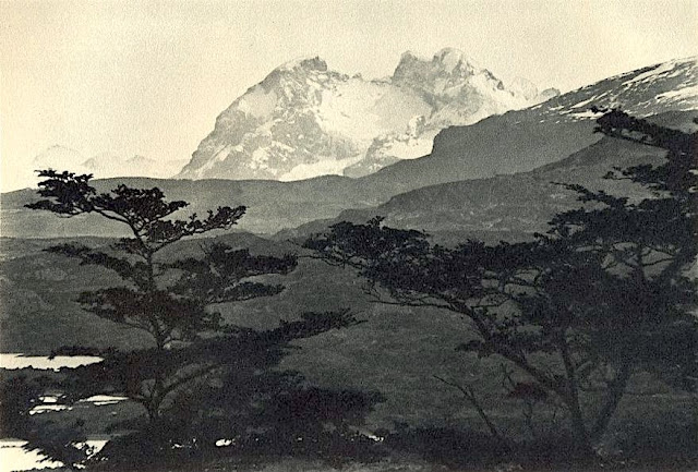
CERRO BALMACEDA PHOTOGRAPHED BY ROBERT GERSTMANN


ROBERT GERSTMANN (1896-1960), Cerro Balmaceda  (2,035 m  - 6,677 ft) Chile  In "Cerro Balmaceda",  glass plate, 1932, University of Antofagasta.

ROBERT GERSTMANN (1896-1960)
Cerro Balmaceda  (2,035 m  - 6,677 ft)
Chile

In "Cerro Balmaceda",  glass plate, 1932, University of Antofagasta.


The photographer
Robert Gerstmann was a photographer very famous in South America. Gerstmann was a Vienna born electrical engineer who, as a young man, developed an interest in photography. In 1924, he immigrated to Chile and from there traveled to Bolivia, where he made some 5000 photographs, a selection of which appear as photogravures in his Bolivia, 150 Grabados en Cobre (1928), which was reissued in 1996 by the Fundación Quipus in La Paz. Gerstmann ranged far, photographing the altiplano from La Paz south to the Argentine border, west to the Chilean border, and east to the Yungas, Cochabamba, Santa Cruz, and the lowlands along the Ríos Beni and Mamoré. Only Tarija and the Chaco escaped his lens. Five of his photographs illustrate Stewart E. McMillan's "The Heart of Aymara Land" National Geographic Magazine (February 1927), and several appear in Gustavo-Adolfo Otero's Bolivia (Guía Sinóptica) 1929. Gerstmann settled in Santiago in 1929. He published other photo albums, including Chile: 280 grabados en cobre (1932), Colombia: 200 grabados en cobre (1951), and Chile en 110 cuadros (1960?), and dabbled in film-making in Bolivia. He is thought to have died in Santiago ca. 1960. Several thousand of his glass plates are said to be at a university in Antofagasta.


The mountain
Cerro Balmaceda (2,035 m - 6,677 ft) is a heavily glaciated mountain located in the Magallanes Region of Chile. It stands at the head of Última Esperanza Sound, in the south portion of Bernardo O'Higgins National Park and near the mouth of the Serrano River. The glaciers Balmaceda and Serrano mantle the slopes of the mount.  In its vicinity is Torres del Paine National Park.
_______________________________
2022 - Wandering Vertexes...
by Francis Rousseau

Friday, March 29, 2019

PARINACOTA AND POMERAPE BY RAMOS CATALAN


RAMOS CATALAN (1888-1961)
El Parinacota  (6,380 m (20,930 ft)
El Pomerape (6,282 m -20,610 ft) 
Chile - Bolivia border 

The mountains
El Parinacota  (6,380 m (20,930 ft) or Parina Quta or Parinaquta is a dormant stratovolcano on the border of Chile and Bolivia. Together with Pomerape it forms the Nevados de Payachata volcanic chain. Part of the Central Volcanic Zone of the Andes, its summit reaches an elevation of 6,380 metres (20,930 ft) above sea level. The symmetrical cone is capped by a summit crater with widths of 1 kilometre (0.62 mi) or 500 metres (1,600 ft). Farther down on the southern slopes lie three parasitic centres known as the Ajata cones. These cones have generated lava flows. The volcano overlies a platform formed by lava domes and andesitic lava flows.
The volcano started growing during the Pleistocene and formed a large cone. At some point between the Pleistocene and the Holocene, the western flank of the volcano collapsed, generating a giant landslide that spread west and formed a large, hummocky landslide deposit. The avalanche crossed and dammed a previously existing drainage, impounding or enlarging Lake Chungará; numerous other lakes now forming the headwaters of the Rio Lauca sprang up within the deposit. Volcanic activity rebuilt the cone after the collapse, cancelling out the collapse scar.
Parinacota had numerous effusive and explosive eruptions during the Holocene, the latest about 200 years ago. While there are no recorded eruptions, legends of the local Aymara people imply that they may have witnessed one eruption. Renewed activity at Parinacota is possible in the future, although the relatively low population density in the region would limit the amount of damage that could occur. Some towns and a regional highway between Bolivia and Chile are potentially exposed to the effects of a new eruption.
El Pomerape  (6,282 m -20,610 ft) is a stratovolcano is part of the Payachata complex of volcanoes, together with Parinacota Volcano to the south. The name "Payachata" means "twins" and refers to their appearance.  It hosts glaciers down to elevations of 5,300–5,800 metres (17,400–19,000 ft), lower on the northern slope.
Pomerape is a complex of lava domes, accompanied by lava flows which were emplaced atop of the domes.  It was active about 200,000 years ago.  The lava domes formed first and were later buried by the actual volcanic cone, which unlike the rhyolitic-dacitic domes is formed by hornblende andesite.  The "Chungará Andesites" and lava dome complex of Parinacota were laid down at this time. Pomerape is associated with an adventive vent that has erupted mafic magmas. The main cone was last active 106,000 +- 7,000 years ago, the adventive vent is dated to 205,000 ± 24,000 years ago.

The painter 
Benito Ramos Catalán (1888-1961) was a chilean  painter who used to sign "Ramos Catalan". Known for his marines and landscapes of the Andes and Chile, and most particularly for his mountains paintings. Most of them have the same title: "Mountains of Chile" or  "Mountains landscapes of Andes", making quite difficult to know which mountain was exactly depicted, in a country which has quite a lot of summits ! To add to the difficulty, he used to paint the most famous mountains of his country under very unusual angles or with proportions that do not correspond exactly to their real size... making even more difficult to recognize and identify them for experts ! That is why today, 55 years after his death, some of these mountains paintings are not clearly identified and presented, in the public sales, as 'possibly' a particular summit of Chile or Andes...
His works are in many Chilean institutions like Viña del Mar Fine Art Museum, O'Higginiano Fine Art Museum in Talca, Valparaiso Fine Art Museum, and Navy  Schools in Valparaiso and Talcahuano, Ranos.

___________________________________________
2019 - Wandering Vertexes...
by Francis Rousseau 

Tuesday, March 12, 2019

CERRO ESCORIAL BY PEDRO LIRA


 PEDRO LIRA (1845-1912) 
Cerro Escorial  (5,451m - 17, 884ft)
Argentina / Chile border

 In  Paisaje Cordillerano, oil on canvas, Museo Nacional de Bellas Artes de Chile   

The mountain 
Cerro Escorial  (5,451m - 17, 884ft) is a stratovolcano at the border of Argentina and Chile. It is part of the Corrida de Cori volcanic group and its youngest member. A well-preserved 1-kilometre-wide (0.6 mi) crater forms its summit area. Lava flows are found on the Chilean and smaller ones on the Argentinian side, the former reaching as far as 3–4 kilometres (1.9–2.5 mi) from the volcano. One of these is dated 342,000 years ago by argon-argon dating.
A Plinian eruption on Escorial was the source of the dacitic Escorial ignimbrite.  Pulsed changes in the magma supply during the eruption generated a radial ignimbrite structure which was deposited in various flows. The source magma underwent significant crustal contamination and contains quartz veins, indicating that the ignimbrite interacted with a buried hydrothermal system. Lithic clasts including basement material are also present. The ignimbrite has a volume of about 0.6 cubic kilometres (0.14 cu mi) and was erupted 460,000±10,000 years ago.
A sulfur mine lies 4 kilometres (2.5 mi) southwest of Escorial. Mining ceased about 1983.

The painter 
Pedro Francisco Lira Rencoret known as Pedro Lira  was a Chilean painter and art critic,  best known for his eclectic portraits of women ans a few landscapes.
He lived in France from 1873 to 1884 and was influenced by Eugène Delacroix, many of whose paintings he copied. Later, he received an "honorable mention" at the Salon, where little recognition was generally given to Latin American artists. But, despite his successes, he decided to return to Chile, as the time appeared ripe to create an artistic milieu comparable to that in Paris.
Soon after his arrival, he organized the first exposition devoted exclusively to Chilean painters. Together with the sculptor José Miguel Blanco, he founded the "Unión Artística", an organization devoted to promoting more exhibitions and, ultimately, creating the Museo Nacional de Bellas Artes de Chile, which was originally located on the second floor of the National Congress Building. He also created a Salon, similar to the one in Paris, and helped establish a museum in the Quinta Normal, where expositions were held until 1910.
In 1892, he was appointed Director of the "Escuela de Bellas Artes", a position he held until his death. While there, he was a mentor for promising new artists. Among the best known painters whose careers he supported are Pablo Burchard, Pedro Reszka Moreau and Celia Castro, the first Chilean woman to become a notable artist. He also compiled Chile's first "Biographical Dictionary of Painters" and translated Hippolyte Taine's Philosophy of Art. Several historical paintings of his have been used on Chilean banknotes.

___________________________________________
2019 - Wandering Vertexes...
by Francis Rousseau 

Tuesday, February 28, 2017

FITZ ROY / CERRO CHALTEN BY RAMOS CATALAN


RAMOS CATALAN (1888-1961) 
Fitz Roy / Cerro Chalten  (3,405m- 11, 171 ft)
Chile - Argentina border

The mountain 
Fitz Roy / Cerro Chalten  (3,405m- 11, 171 ft) is a mountain located near El Chaltèn village, in the Southern Patagonian Ice Field in Patagonia, on the border between Argentina and Chile. First climbed in 1952 by French alpinists Lionel Terray and Guido Magnone, " The Fitz Roy " remains among the most technically challenging mountains for mountaineers on Earth. Mount Fitz Roy is the basis for the Patagonia clothing logo following Yvon Chouinard's ascent and subsequent film in 1968.
Argentine explorer Francisco Moreno first saw the mountain on 2 March 1877. He named it Fitz Roy, in honour of Robert FitzRoy, who, as captain of the HMS Beagle had travelled up the Santa Cruz River in 1834 and charted large parts of the Patagonian coast.
Cerro is a Spanish word meaning mountain, while Chaltèn comes from a Tehuelche (Aonikenk) word meaning "smoking mountain", due to a cloud that usually forms around the mountain's peak. Fitz Roy, however, was only one of a number of peaks the Tehuelche called Chaltèn.
It has been agreed by Argentina and Chile that their international border detours eastwards to pass over the main summit, but a large part of the border to the south of the summit, as far as Cerro Murallуn, remains undefined.

The painter 
Benito Ramos Catalán (1888-1961) was a chilean  painter who used to sign "Ramos Catalan". Known for his marines and landscapes of the Andes and Chile, and most particularly for his mountains paintings. Most of them have the same title: "Mountains of Chile" or  "Mountains landscapes of Andes", making quite difficult to know which mountain was exactly depicted, in a country which has quite a lot of summits ! To add to the difficulty, he used to paint the most famous mountains of his country under very unusual angles or with proportions that do not correspond exactly to their real size... making even more difficult to recognize and identify them for experts ! That is why today, 55 years after his death, some of these mountains paintings are not clearly identified and presented, in the public sales, as 'possibly' a particular summit of Chile or Andes...
His works are in many Chilean institutions like Viña del Mar Fine Art  Museum, O'Higginiano Fine Art Museum in Talca, Valparaiso Fine Art Museum, and Navy  Schools in Valparaiso and Talcahuano. Ranos

Friday, January 1, 2021

VICTORIA PEAK PAINTED BY ERNEST CHARTON DE TREVILLE


ERNEST CHARTON DE TREVILLE (1816-1877)
Victoria Peak  (552 m -1,811 ft)
China (Hong Kong)
 
In Victoria Peak vu de la Baie de Hong Kong, Oil on canvas, Private collection 

The mountain
Victoria Peak (552 m -1,811 ft) or 太平山 (in Chinese) also locally called The Peak or Mount Austin an sa few others cantonese and Hong Kong Hakka names such as Taai Pen Saa or Deng or Saan Deng or Ce Kei Saan or Lou Fung... is a mountain in the western half of Hong Kong Island. It is the highest mountain on Hong Kong island, ranked 31 in terms of elevation in the Hong Kong Special Administrative Region ; Tai Mo Shan (957m) being the highest point in the Hong Kong Special Administrative Region.The summit is occupied by a radio telecommunications facility and is closed to the public. However, the surrounding areaf public parks and high-value residential land is the area that is normally meant by the name The Peak. During the19th century, the Peak attracted prominent European residents because of its panoramic view over the city and its relatively temperate climate compared to the sub-tropical climate in the rest of Hong Kong. The sixth Governor of Hong Kong, Sir Richard MacDonnell had a summer residence built on the Peak circa 1868. Those that built houses named them whimsically, such as The Eyrie, and the Austin Arm. These original residents reached their homes by sedan chairs, which were carried up and down the steep slope of Victoria Peak.

The painter
Ernest-Marc-Jules Charton Thiessen of Treville better known as Ernest Charton or Ernesto Charton was a French painter, famous for his pastel portraits and realistic- style customary paintings. He made most of his artistic career in South America - particularly in Argentina Chile and Ecuador -, a continent where his first name, as was customary at the time, was Castilianized, which is why he was known as Ernesto Charton.
He was initially established in Valparaíso (Chile), but in 1848 he moved to Santiago where he opened a studio neighboring that of Raymond Monvoisin, another French pioneer of Chilean painting and also belonging to traveling artists as was also at that time the watercolorist Carlos Wood.
Brother of Edouard Charton, director of the Parisian magazine Le Tour du Monde Ernesto was a typical adventurous artist of the nineteenth century in search of the most exotic expressions of unexplored nature, following in this aspect the motivation of numerous European painters of the time.  Many of his American experiences were reflected in the L'llustration, a magazine also directed by his brother and of which he was a correspondent, sending not only chronicles but also drawings, such as those he sent from the streets of Valparaíso before the bombing. He also sent a drawing of the bombing of Callao, which was recorded by Louis Le Breton and published on June 23.
Tempted by the gold rush in California he embarked on October 25, 1848 on the schooner Rosa Segunda, who arrived in the Galapagos Islands within two weeks to get water; when most of the passengers were ashore, the ship abandoned them to their fate. The painter, like his companions, lost everything, including his works.
Charton, who in 1862 would return to Ecuador, managed to settle in Quito with the help of the French consul. He taught drawing and painting at the University of that city; in addition, he directed the Miguel de Santiago Liceo of Painting, a direct antecedent of the School of Fine Arts of that country. As a result of his stay in Ecuador, he left a 48-watercolors album (cf. above)
He returned to France, but in 1855 he returned to Chile with his family; he gained fame as a portraitist, landscaper and teacher. In this last quality he had a famous controversy with the first director of the Academy of Painting of Santiago. ]
In 1870 he left Chile to Argentina, crossing the Andes. From that experience, his large oil painting was born the following year View of the Andes mountain range (115x197cm) that is today in the National Museum of Fine Arts of that country, in Buenos Aires, city where he settled until his death.
In addition to the countries mentioned, he travelled in Italy, Panama (when it was still part of Colombia) Peru and China (Hong Kong, Macao) (see above). 
As a Photographer, he used snapshots as a base for his paintings, portraying typical clothes, customs and parties that he then tracked to the web.
Charton's works are characterized by their vibrant color and the realistic expression of popular customs and motifs. He left among his students from Chile, Ecuador and Argentina this cultural vision of pictorial realism applied to the theme of each country, leaving aside religious, mythological or literally copied motifs of European models.
His paintings can be seen in museums in Argentina, Chile and Ecuador.

__________________________________________

2021 - Wandering Vertexes / Mountain paintings
By F rancis Rousseau


___________________________________

2021 - Wandering Vertexes
A blog by Francis Rousseau

Tuesday, September 17, 2019

EL CHIMBORAZO BY ERNEST CHARTON DE TREVILLE


ERNEST CHARTON  DE TREVILLE (1816-1877)
Chimborazo  (6,263.47m - 20,549.4 ft)
Ecuador

In El Chimborazo, 1863, watercolor from  48 views of Ecuador, Chilean Museum of Fine Arts

The mountain
Chimborazo  (6,263 m -20,548 ft) is a currently inactive stratovolcano in the Cordillera Occidental range of the Andes ans the highest mountain in Ecuador and the Andes north of Peru ; it is higher than any more northerly summit in the Americas. Chimborazo is not the highest mountain by elevation above sea level, but its location along the equatorial bulge makes its summit the farthest point on the Earth's surface from the Earth's center.
Chimborazo is at the main end of the Ecuadorian Volcanic Arc, north west of the town of Riobamba. Chimborazo is in la Avenida de los Volcanes (the Avenue of Volcanoes) west of the Sanancajas mountain chain. Carihuairazo, Tungurahua, Tulabug, and El Altar are all mountains that neighbor Chimborazo.  The closest mountain peak, Carihuairazo, is 5.8 mi (9.3 km) from Chimborazo. There are many microclimates near Chimborazo, varying from desert in the Arenal to the humid mountains in the Abraspungo valley. Its last known eruption is believed to have occurred around A.D. 550. 
Until the beginning of the19th century, it was thought that Chimborazo was the highest mountain on Earth (measured from sea level), and such reputation led to many attempts on its summit during the 17th and 18th centuries.
In 1746, the volcano was explored by French academicians from the  French Geodesic Mission. Their mission was to determine the sphericity of the Earth. Their work along with another team in Lapland established that the Earth was an oblate spheroid rather than a true sphere. They did not reach the summit of Chimborazo.
In 1802, during his expedition to South America, Baron Alexander von Humboldt (on left in the painting above)  accompanied by Aimé Bonpland (on right in the painting above) and the Ecuadorian Carlos Montufar (on left with Humboldt  in the painting above), tried to reach the summit. From his description of the mountain, it seems that before he and his companions had to return suffering from altitude sickness they reached a point at 5,875 m, higher than previously attained by any European in recorded history. (Incas had reached much higher altitudes previously). In 1831, Jean-Baptiste Boussingault and Colonel Hall reached a new "highest point", estimated to be 6,006 m.

The Painter 
Ernest-Marc-Jules Charton Thiessen of Treville  better known as Ernest Charton or Ernesto Charton was a French painter, famous for his pastel portraits and realistic- style customary paintings. He made most of his artistic career in South America - particularly in Argentina  Chile and Ecuador -, a continent where his first name, as was customary at the time, was Castilianized, which is why he was known as Ernesto Charton.
He was initially established in Valparaíso (Chile), but in 1848 he moved to Santiago  where he opened a studio neighboring that of Raymond Monvoisin, another French pioneer of Chilean painting and also belonging to traveling artists  as was also at that time the watercolorist Carlos Wood.
Brother of Edouard Charton, director of the Parisian magazine Le Tour du Monde  Ernesto was a typical adventurous artist of the nineteenth century  in search of the most exotic expressions of unexplored nature, following in this aspect the motivation of numerous European painters of the time.  Many of his American experiences were reflected in the L'llustration , a magazine also directed by his brother and of which he was a correspondent, sending not only chronicles but also drawings, such as those he sent from the streets of Valparaíso before the bombing. He also sent a drawing of the bombing of Callao, which was recorded by Louis Le Breton and published on June 23.
Tempted by the gold rush in California  he embarked on October 25, 1848 on the schooner Rosa Segunda, who arrived in the Galapagos Islands within two weeks to get water; when most of the passengers were ashore, the ship abandoned them to their fate. The painter, like his companions, lost everything, including his works. 
Charton, who in 1862 would return to Ecuador, managed to settle in Quito with the help of the French consul. He taught drawing and painting at the University of that city; in addition, he directed the Miguel de Santiago Liceo of Painting, a direct antecedent of the School of Fine Arts of that country. As a result of his stay in Ecuador, he left a 48-watercolors album (cf. above) 
He returned to France, but in 1855 he returned to Chile with his family; he gained fame as a portraitist, landscaper and teacher. In this last quality he had a famous controversy with the first director of the Academy of Painting of Santiago. ]
In 1870 he left Chile to Argentina, crossing the Andes. From that experience, his large oil painting was born the following year View of the Andes mountain range (115x197cm) that is today in the National Museum of Fine Arts (MNBABA) of that country, in Buenos Aires, city where he settled until his death. 
In addition to the countries mentioned, he travelled in Italy, Panama (when it was still part of Colombia) and Peru .
As a Photographer, he used snapshots as a base for his paintings, portraying typical clothes, customs and parties that he then tracked to the web.
Charton's works are characterized by their vibrant color and the realistic expression of popular customs and motifs. He left among his students from Chile, Ecuador and Argentina this cultural vision of pictorial realism applied to the theme of each country, leaving aside religious, mythological or literally copied motifs of European models.
His paintings can be seen in museums in Argentina, Chile and Ecuador.

___________________________________

2019  - Wandering Vertexes
A blog by Francis Rousseau

Monday, December 30, 2019

CERRO ESCORIAL (2) PAINTED BY PEDRO LIRA


PEDRO LIRA (1845-1912)
Cerro Escorial (5,451 m - 17, 884 ft)
Chile - Argentina border

In Paisaje con cordillera y vacunos, oil on canvas, 1899

The mountain
Cerro Escorial (5,451 m - 17, 884 ft) is a stratovolcano at the border of Argentina and Chile. It is part of the Corrida de Cori volcanic group and its youngest member. A well-preserved 1-kilometre-wide (0.6 mi) crater forms its summit area. Lava flows are found on the Chilean and smaller ones on the Argentinian side, the former reaching as far as 3–4 kilometres (1.9–2.5 mi) from the volcano. One of these is dated 342,000 years ago by argon-argon dating.
A Plinian eruption on Escorial was the source of the dacitic Escorial ignimbrite. Pulsed changes in the magma supply during the eruption generated a radial ignimbrite structure which was deposited in various flows. The source magma underwent significant crustal contamination and contains quartz veins, indicating that the ignimbrite interacted with a buried hydrothermal system. Lithic clasts including basement material are also present. The ignimbrite has a volume of about 0.6 cubic kilometres (0.14 cu mi) and was erupted 460,000±10,000 years ago.
A sulfur mine lies 4 kilometres (2.5 mi) southwest of Escorial. Mining ceased about 1983.

The painter 
Pedro Francisco Lira Rencoret known as Pedro Lira  was a Chilean painter and art critic,  best known for his eclectic portraits of women ans a few landscapes.
He lived in France from 1873 to 1884 and was influenced by Eugène Delacroix, many of whose paintings he copied. Later, he received an "honorable mention" at the Salon, where little recognition was generally given to Latin American artists. But, despite his successes, he decided to return to Chile, as the time appeared ripe to create an artistic milieu comparable to that in Paris.
Soon after his arrival, he organized the first exposition devoted exclusively to Chilean painters. Together with the sculptor José Miguel Blanco, he founded the "Unión Artística", an organization devoted to promoting more exhibitions and, ultimately, creating the Museo Nacional de Bellas Artes de Chile, which was originally located on the second floor of the National Congress Building. He also created a Salon, similar to the one in Paris, and helped establish a museum in the Quinta Normal, where expositions were held until 1910.
In 1892, he was appointed Director of the "Escuela de Bellas Artes", a position he held until his death. While there, he was a mentor for promising new artists. Among the best known painters whose careers he supported are Pablo Burchard, Pedro Reszka Moreau and Celia Castro, the first Chilean woman to become a notable artist. He also compiled Chile's first "Biographical Dictionary of Painters" and translated Hippolyte Taine's Philosophy of Art. Several historical paintings of his have been used on Chilean banknotes.

___________________________________________ 

2019 - Wandering Vertexes...
by Francis Rousseau


Friday, October 5, 2018

TWIN VOLCANOES PARINACOTA & POMERAPE BY RAFAEL SALAS

wanderingvertexes.blogspot.com

RAFAEL SALAS  (1824-1906)  
Parinacota  (6,348 m - 20,827ft)
Pomerape (6,282m-20,610ft)
Chile - Bolivia border 

In Bista del Pomerope and Parinacota, oil on canvas, 1870  

The Mountains 
Parinacota (6,348 m-20,827ft) or Parina Quta or Parinaquta  and Pomerape (6,282m-20,610ft) are two twin massive dormant stratovolcanoes on the border of Chile and Bolivia.  The range they are part of, Cerros de Payachata, means twin mountains and there are only those two peaks in the range.
It is usually counted as a sub-range in the Cordillera Occidental,  part of the Payachata volcanic  Pleistocene group. Both volcanoes are right on the Chilean - Bolivian border and can be climbed from either side. Their closest neighbor is Bolivia's highest mountain Sajama (6,542m-21,463ft) which isn't more than 20km away.
Parinacota is located in the extreme NE of Chile, where the country borders to Bolivia. The closest really large city is La Paz, the capital of Bolivia, which is about 300km and five hours away. Arica, in Chile is at the Pacific coast and is about 180 km far (and almost 5000 vertical meters!).
 Parinacota's last eruptive phase has been dated using the helium surface exposure technique, which ties the eruption to 290AD ± 300 years.
One of the most dramatic eruptive events in the volcano's past was 8,000 years ago, when a major collapse of the edifice produced a 6 kmі (1.44 cubic miles) debris avalanche, which blocked nearby drainage patterns, creating Chungara Lake.
The volcano and Pomerape straddle the border between Sajama National Park (Bolivia) and Lauca National Park (Chile).

The painter 
Rafael Salas was an important Ecuadorian  landscape and genre painter  of nineteenth century South America neoclassicism. He was the last son of the famous Salas artists dynasty among which  his  half brother Ramon Salas ( 1815-1880), the fist professor a t Academy of fine Arts of Quito and  responsive for the taste of Costumbrismo; and above all their father Antonio Salas (1795-1860) a colonial artist specialized in religious themes like La Muerte de San José and La Negacion de San Pedro in the Cathedral of Quito.

2018 - Wandering Vertexes
Un blog de Francis Rousseau 

Friday, July 8, 2022

EL VULCAN PLANCHÒN-PETEROA PHOTOGRAPHED BY LEO WEHRLI


LEO WEHRLI (1870–1954) El Planchón-Peteroa (4,107 m - 13,474 ft) Argentina- Chile border  In Planchon Vulcan photo1897, hand colorized by Anna Wehrli-Frey 1918, ETH Library, Zurich

LEO WEHRLI (1870–1954)
El Planchón-Peteroa (4,107 m - 13,474 ft)
Argentina- Chile border

In Planchon Vulcan, photo,1897, hand colorized by Anna Wehrli-Frey 1918,
ETH Library, Zurich


The volcano
EL Planchón-Peteroa (4,107m - 13,474 ft) also known as Azufre-Planchón-Peteroa or Nevado de los Banos is a complex of active volcanoes extending in a north–south direction along the border between Argentina and Chile. It consists of volcanoes of various ages with several overlapping calderas. Those include Volcán Planchón, Volcán Peteroa and Volcán Azufre. A partial collapse of the complex about 11,500 years ago produced a major debris avalanche, which followed the course of the Teno River until reaching the Chile Central Valley. Peteroa has a crater lake. Lagunas de Teno lies at the foot of Planchón volcano. In this area also is the Vergara International Pass.
Planchón-Peteroa Volcano erupted on September 6, followed by a stronger eruption on September 18. On September 6, 2010, , the volcano erupted once again, emitting a dark gray plume of volcanic ash. As winds blew the ash southeast into Argentina, residents there were warned by authorities to evacuate the nearby areas before Planchón-Peteroa would erupt again.

The photographer
Leo Wehrli was a Swiss geologist, professor and explorer. After studying music, botany, chemistry, mineralogy, petrography and geology in Berlin and Zurich, Wehrli became assistant to Albert Heim. Immediately after completing his thesis, he left for Argentina with the famous Carl Emanuel Burckhardt in 1896. Accredited by the La Plata Museum and the government of Argentina, he explored the Andes he crossed at least five times during a stay of two years. His work was more particularly oriented on the delimitation of the border between Argentina and Chile after the agreement signedbetween these two countries in 1881 and on the determination of the property of mountain peaks, ridge lines and basins slopes.
After his return to Switzerland, he worked between 1900 and 1935 as a teacher and then lecturer for the Geol. Centralblatt in Berlin ; between 1901 and 1912, he wrote nearly 500 articles. He made other trips through Europe and North Africa (Egypt) before going back to Argentina again in 1938. He has summarized his research results in numerous articles, notably in the Geographic Lexicon of Switzerland. He participated in the founding of the Zurich Adult Education Center and gave lectures there from 1921 to 1953. From 1931 to 1951 he was a member of the Swiss Alpine Club SAC commission for the Central Library and has was president for 14 years.
Wehrli left a collection of 15,000 slides, some of which were hand-colored by his wife, born Anna Frey. A large part of the works is made available online by the photographic archives of the ETH-Bibliothek in Zurich.

___________________________________________

2022 - Wandering Vertexes...
by Francis Rousseau

Friday, August 30, 2019

CERRO ACONCAGUA PAINTED BY ANTONIO SMITH


ANTONIO SMITH (1832–1877)
Cerro Aconcagua (6, 961m - 22,838ft) 
Argentina 

In Santiago de Chile desde Peñalolen, oil on canvas, 1875, Private collection

The mountain
Cerro Aconcagua (6,961 meters -22,838 ft) is the highest mountain outside of Asia and by extension the highest point in both the Western Hemisphere and the Southern Hemisphere. The origin of the name is contested; it is either from the Mapuche "Aconca-Hue", which refers to the Aconcagua River, the Quechua "Ackon Cahuak", meaning "Sentinel of Stone", or Quechua "Anco Cahuac", meaning "White Sentinel" or the Aymara "Janq'u Q'awa" meaning "White Ravine", "White Brook".
Aconcagua is located in the Andes mountain range, in the Mendoza Province, Argentina, and lies 112 kilometers (70 mi) northwest of its capital, the city of Mendoza and 108 km (67 mi) from Santiago de Chile (the capital of Chile). The summit is in fact located about 5 kilometers from San Juan Province and 15 kilometers from the international border with Chile; its nearest higher neighbor is Tirich Mir in the Hindu Kush, 16,520 kilometers (10,270 mi) away.
Aconcagua is one of the Seven Summit, which includes the highest mountains of each of the seven continents.  The 7 summits (which are obviously 8 !)... are :
Mt Everest (8,848m), Aconcagua (6,961m), Mt Denali or Mc Kinley (6,194m), Kilimandjaro (5,895m), Mt Elbrus (5,642m), Vinson Massif (4,892m), Mt Blanc (4,807m) and Mount Kosciuszko (2,228m).
Summiting all of them is regarded as a mountaineering challenge, first achieved on April 30, 1985 by Richard Bass.  Aconcagua was created by the subduction of the Nazca Plate beneath the South American Plate during the geologically recent Andean orogeny; but it is not a volcano. It is bounded by the Valle de las Vacas to the north and east and the Valle de los Horcones Inferior to the west and south. The mountain and its surroundings are part of the Aconcagua Provincial Park. The mountain has a number of glaciers. The largest glacier is the Ventisquero Horcones Inferior at about 10 km long, which descends from the south face to about 3600 m altitude near the Confluencia camp. Two other large glacier systems are the Ventisquero de las Vacas Sur and Glaciar Este/Ventisquero Relinchos system at about 5 km.

The painter
Miguel Antonio Smith Irisarri was a Chilean landscape painter, engraver, caricaturist and art teacher.
His father, Jorge, was a native of Scotland and served as the consul in Santiago. His mother, Carmen, was the daughter of independence leader Antonio José de Irisarri and the sister of poet Hermógenes Irisarri. His family wanted him to be a lawyer. With his own money, he purchased brushes and paints, but they were thrown away.
The failure of the Revolution of 1859 forced him to emigrate. He decided to go to France and, after a short time, became reasonably successful. However, the Bohemian lifestyle he had adopted caused him to squander his money, so he had to go to the United States to seek financial assistance from his grandfather, Antonio José, who at that time was a diplomat in New York. He then went to Italy, where he spent a year working with the landscape painter Carlo Marco. After that, he decided to return to Chile, despite the dangers involved in sea travel during the Chincha Islands War.
In 1866, following a difficult six-month voyage, he landed at San Antonio and joined a group of firefighters from Santiago, although he did not remain with them for long. Serious cultural reforms were sweeping the country, but he was amazed to see how little had changed at the Academy. That is, Ciccarelli was still in charge, so Smith established his own teaching workshop. In 1869, Ciccarelli was replaced by Ernst Kirchbach, a German painter who was more amenable to Smith, and they began sharing students. Some of his best-known students include Alfredo Valenzuela Puelma, Pedro Lira, Alberto Orrego Luco, Onofre Jarpa and Cosme San Martín.
Although an excellent teacher, he was very disorganized, painting when the mood struck him. As a result, many of his works were done quickly or left unfinished. His many imitators often make it difficult to assign authorship with certainty. The majority of his paintings are in private collections.

___________________________________________
2019 - Wandering Vertexes...
by Francis Rousseau 

Sunday, March 21, 2021

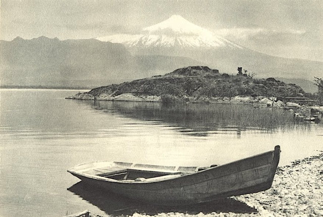
VOLCÀN ORSONO PHOTOGRAPHED BY ROBERT GERSTMANN


https://wanderingvertexes.blogspot.com/2021/03/volcan-orsono-photographed-by-robert.html

ROBERT GERSTMANN (1896-1960)
Volcàn Orsono (2,652 m - 8700 ft)
Chile

in Lago Villarrica e Volcan Orsono, photo, 1932


The volcano
The Osorno is a stratovolcano located between the province of Osorno and that of Llanquihue, in the Lakes region of Chile. At an altitude of 2,652 meters, it is the most active volcano in the southern Chilean Andes.  It rises to the east of Lake Llanquihue, known worldwide as a symbol of the local landscape. The volcano also dominates Lake Todos los Santos. Its last eruption dates from 1869. Charles Darwin saw the Osorno from afar on his second voyage on HMS Beagle and witnessed its eruption1 in January 18352. Its first ascent was made in 1848 by Jean Renous.

The photographer
Robert Gerstmann was a photographer very famous in South America. Gerstmann was a Vienna born electrical engineer who, as a young man, developed an interest in photography. In 1924, he immigrated to Chile and from there traveled to Bolivia, where he made some 5000 photographs, a selection of which appear as photogravures in his Bolivia, 150 Grabados en Cobre (1928), which was reissued in 1996 by the Fundación Quipus in La Paz. Gerstmann ranged far, photographing the altiplano from La Paz south to the Argentine border, west to the Chilean border, and east to the Yungas, Cochabamba, Santa Cruz, and the lowlands along the Ríos Beni and Mamoré. Only Tarija and the Chaco escaped his lens. Five of his photographs illustrate Stewart E. McMillan's "The Heart of Aymara Land" National Geographic Magazine (February 1927), and several appear in Gustavo-Adolfo Otero's Bolivia (Guía Sinóptica) 1929. Gerstmann settled in Santiago in 1929. He published other photo albums, including Chile: 280 grabados en cobre (1932), Colombia: 200 grabados en cobre (1951), and Chile en 110 cuadros (1960?), and dabbled in film-making in Bolivia. He is thought to have died in Santiago ca. 1960. Several thousand of his glass plates are said to be at a university in Antofagasta. 


_______________________________
2021 - Wandering Vertexes...
by Francis Rousseau

Sunday, December 10, 2017

NEVADO DE LONGAVI BY RAMOS CATALAN


 RAMOS CATALAN (1888-1961) 
Nevado de Longavi (3,242m- 10,636ft)
 Chile 

The mountain 
Nevado de Longavi   (3,242m- 10,636ft) is a volcano in the Andes of central Chile located in the Linares Province and the Maule Region. It features a summit crater and several parasitic craters. The volcano is constructed principally from lava flows. Two collapses of the edifice have carved collapse scars into the volcano, one on the eastern slope known as Lomas Limpias and another on the southwestern slope known as Los Bueye. The volcano featured a glacier in 1976 and is the headwater of the Achibueno and Blanco rivers.
The oldest volcanic activity occurred one million years ago. After a first phase characterized by basaltic andesite effusion, the bulk of the edifice was constructed by andesitic lava flows. 
Nevado de Longavi features an unusual magma chemistry that resembles adakite. It may be the consequence of the magma being unusually water-rich; such may occur because the Mocha fracture zone subducts beneath the volcano.
Nevado de Longavi was active during the Holocene. 6,835 ± 65 or 7,500 years before present an explosive eruption deposited pumice over 20 kilometres (12 mi) away from the volcano. A lava flow was then erupted over the pumice. The last eruption occurred about 5,700 years ago and formed a lava dome. The volcano has no historic eruptions but features fumarolic activity.

The painter 
Benito Ramos Catalán (1888-1961) was a chilean  painter who used to sign "Ramos Catalan". Known for his marines and landscapes of the Andes and Chile, and most particularly for his mountains paintings. Most of them have the same title: "Mountains of Chile" or  "Mountains landscapes of Andes", making quite difficult to know which mountain was exactly depicted, in a country which has quite a lot of summits ! To add to the difficulty, he used to paint the most famous mountains of his country under very unusual angles or with proportions that do not correspond exactly to their real size... making even more difficult to recognize and identify them for experts ! That is why today, 55 years after his death, some of these mountains paintings are not clearly identified and presented, in the public sales, as 'possibly' a particular summit of Chile or Andes...
His works are in many Chilean institutions like Viña del Mar Fine Art Museum, O'Higginiano Fine Art Museum in Talca, Valparaiso Fine Art Museum, and Navy  Schools in Valparaiso and Talcahuano, Ranos.

Saturday, August 31, 2019

COPAHUE VOLCANO PAINTED BY ONOFRE JARPA-LABRA


ONOFRE JARPA-LABRA (1849 - 1940)  
 Copahue volcano (2,997 m - 9,833 ft)
Chile, Argentina border

In En la Cordillera de Chillan, Quebrada el Manzano 1893, oil on canvas, 200 x1 31cm, 
 Museo Nacional de Bellas Artes, Santiago, Chile

The volcano
Copahue  (2,997 m  - 9,833 ft) is a stratovolcano in the Andes on the border of Bío Bío Region, Chile and Neuquén Province, Argentina. There are nine volcanic craters along a 2 km (1.2 mi) line, the easternmost of which is historically the most active, and contains a 300 m (1000 ft) wide crater lake. Eruptions from this crater lake have ejected pyroclastic rocks and chilled liquid sulfur fragments. Although the lake emptied during the 2000 eruption, it later returned to its previous levels. Copahue means "sulphur waters" in Mapuche.
The modern structure is an elongated shield volcano, with a maximum thickness of 22 km and a minimum of 8 km. It has erupted ten times since 1900, most recently in March 2016.[
 On 27 May 2013, it was reported that a red alert had been issued and the evacuation of around 2,000 people was to begin.

The painter 
 The  Chilean landscape painter  Onofre Jarpa Labra was a Romantic style painter and an essayist on various artistic topics. His education began at the Instituto Nacional, a prestigious school that has produced many of Chile's presidents. He continued his studies at the Academia de Bellas Artes, directed by the conservative Italian painter Alejandro Ciccarelli, who resigned in 1869 and was replaced by the German painter, Ernesto Kirchbach, who took a progressive approach that was more amenable to Jarpa's temperament.
In 1875, he won second prize at an international exhibition in Santiago and, six years later, received a government grant to study in Europe, where he visited Spain, Rome and Paris. In Spain, he worked with Francisco Pradilla, who had a major influence on his style. His most important period, however, came during his stay in Venice, where his style became more Naturalistic and he began producing still-lifes. He also became devoted to painting en plein air. After his European tour, he visited the Holy Land, where he painted scenes from the River Jordan and Mount Carmel.
Upon returning to Chile, he became a teacher. Among his best-known students were José Tomás Errázuriz, Alberto Valenzuela Llanos and the caricaturist Jorge Délano Frederick.  He resisted the trends toward French Impressionism, represented by his former classmate, Juan Francisco González, although he was on good terms with the Grupo Montparnasse and the Generación del 13.
In addition to his landscapes and still lifes, he painted several portraits of notable public figures. A quiet, deeply religious man, he continued to paint almost until the day of his death. Most of his works are now in private collection.

____________________________________________
2019 - Men Portraits 
Un blog de Francis Rousseau

Wednesday, May 31, 2017

CERRO MACA BY RAMOS CATALAN


RAMOS CATALAN (1888-1961)
Cerro Macá  (2, 300m - 7, 500ft)    
Chile

In Mountains landscapes of Andes, oil on canvas,Valparaiso Art Museum / Palazzo Barburizza

The mountain 
Cerro Macá  (2, 300m - 7, 500ft) - not to be be confused with Mount Maca in Mozambique, Africa -  is a stratovolcano located to the north of the Aisen Fjord and to the east of the Moraleda Channel, in the Aysen del General Carlos Ibanez del Campo Region of Chile.  Part of the Andes, this glacier-covered volcano lies along the regional Liquiсe-Ofqui Fault Zone. It has erupted basalt.
This peak has no ascents officially registered by  professional climbers.
 Source: 

The painter 
Benito Ramos Catalán (1888-1961) was a chilean  painter who used to sign "Ramos Catalan". Known for his marines and landscapes of the Andes and Chile, and most particularly for his mountains paintings. Most of them have the same title: "Mountains of Chile" or  "Mountains landscapes of Andes", making quite difficult to know which mountain was exactly depicted, in a country which has quite a lot of summits ! To add to the difficulty, he used to paint the most famous mountains of his country under very unusual angles or with proportions that do not correspond exactly to their real size... making even more difficult to recognize and identify them for experts ! That is why today, 55 years after his death, some of these mountains paintings are not clearly identified and presented, in the public sales, as 'possibly' a particular summit of Chile or Andes...
His works are in many Chilean institutions like Viña del Mar Fine Art Museum, O'Higginiano Fine Art Museum in Talca, Valparaiso Fine Art Museum, and Navy  Schools in Valparaiso and Talcahuano, Ranos.

Monday, October 10, 2022

THE FIZTROY (?) PAINTED BY RHOD WULFARS


RHOD WULFARS (bn. 1979), The Fitz Roy / Cerro Chalten (3,405 m- 11, 171 ft) Chile - Argentina border


RHOD WULFARS (bn. 1979),
The Fitz Roy / Cerro Chalten (3,405 m- 11, 171 ft)
Chile - Argentina border

About this painting
The painter wrote: “It is not a real mountain. Most of my paintings are born from the combination of the imagination and the hours spent looking, walking and smelling them. I call them "Twins" because they are similar to those reliefs of the Argentinian Andean Coridilla called "acarreos", which are long slopes of very popular loose rock that can be easily viewed. very frequently observed. This painting is therefore that of an unknown mountain, dreamt up which sums up several, and which came out of my unconscious one afternoon when the brush gave it life in a mysterious way without my being able to explain it. "
The artist
Rhod Wulfars is a contemporary mountain painter using mainly acrylic technique for his paintings.
He was born in 1979 in Mendoza (Argentina). In his website he wrote: "I have spent my whole life by the mountains. On day I started to paint them". Using, in the manner of Nicolas de Staël, a style always beetween abstract and figurative, his very strong and very moving paintings described perfectly the majesty and the spectacular contents of the peaks he paints. Rhod Wulfars makes a surprising use of acrylic medium, in thick paste as one could do with oil paint. He used to named his works only bu numbers, and series letters, but sometime he writes the name of the peaks ans makes it more easy to identify. Other works by this artist on his website : rhodwulfars.wixsite.com/rhodwulfars/


The mountain
Fitz Roy / Cerro Chalten (3,405m- 11, 171 ft) is a mountain located near El Chaltèn village, in the Southern Patagonian Ice Field in Patagonia, on the border between Argentina and Chile. First climbed in 1952 by French alpinists Lionel Terray and Guido Magnone, " The Fitz Roy " remains among the most technically challenging mountains for mountaineers on Earth. Mount Fitz Roy is the basis for the Patagonia clothing logo following Yvon Chouinard's ascent and subsequent film in 1968.
Argentine explorer Francisco Moreno first saw the mountain on 2 March 1877. He named it Fitz Roy, in honour of Robert FitzRoy, who, as captain of the HMS Beagle had travelled up the Santa Cruz River in 1834 and charted large parts of the Patagonian coast.
Cerro is a Spanish word meaning mountain, while Chaltèn comes from a Tehuelche (Aonikenk) word meaning "smoking mountain", due to a cloud that usually forms around the mountain's peak. Fitz Roy, however, was only one of a number of peaks the Tehuelche called Chaltèn.
It has been agreed by Argentina and Chile that their international border detours eastwards to pass over the main summit, but a large part of the border to the south of the summit, as far as Cerro Murallуn, remains undefined.

______________________________
2022- Wandering Vertexes
Un blog de Francis Rousseau

Thursday, February 6, 2020

CERRO CHACHE PAINTED BY ONOFRE JARPA-LABRA


ONOFRE JARPA-LABRA (1849 - 1940)
Cerro Chache   (2, 333 m  - 7,654 ft)
Chile

In Cordillera de Petorca,  oil on canvas, 1933, Museo nacional debellas Artes Santiago, Chile 


The mountain 
Cerro Chache is a Chilean mountain, the highest summit of the central Costa mountain range, located in Cabildo in the Valparaíso Region. It is part of the so-called Melon mountain range, which runs between the La Ligua River and the Aconcagua River. The Cerro Chache is accessed by the Las Pataguas Mineral, just over 15 km southeast of La Ligua. Its approach and ascent involve at least two days of excursion.
From its summit you can see Mount Aconcagua, Cerro La Campana, Cerro El Roble, as well as much of the Melon mountain range and the coast of the Valparaíso region.
It is common to read that El Roble Hill or that the Altos de Cantillana correspond to the highest heights of the Costa mountain range in its central section. However, there are certain sources that cite the Chache hill as the highest altitude. The discussion basically lies in the interlacing of mountain ranges that predominate in this transitional zone from Transversal Valleys to Longitudinal Valley, which causes confusion when talking about Chache Hill, when taking it as part of the transverse cord that separates the hydrographic holes of the La Ligua River and the Aconcagua River. This thesis is denied, when studying the letters of the Military Geographical Institute or ascending to the hill El Roble or the hill La Campana, and realizing that the Chache hill is in a continuous line towards the north, distancing itself from the sea almost by the same kilometers in a straight line, like the El Roble hill, and also that the adjacent transverse cord, in the east direction, which joins it to the Andes mountain range, is of lower altitude than the entire Melon mountain range, where the Chache hill. These tests make it the highest altitude of this section of the Chilean Coast Range.

The painter 
The  Chilean landscape painter  Onofre Jarpa Labra was a Romantic style painter and an essayist on various artistic topics. His education began at the Instituto Nacional, a prestigious school that has produced many of Chile's presidents. He continued his studies at the Academia de Bellas Artes, directed by the conservative Italian painter Alejandro Ciccarelli, who resigned in 1869 and was replaced by the German painter, Ernesto Kirchbach, who took a progressive approach that was more amenable to Jarpa's temperament.
In 1875, he won second prize at an international exhibition in Santiago and, six years later, received a government grant to study in Europe, where he visited Spain, Rome and Paris. In Spain, he worked with Francisco Pradilla, who had a major influence on his style. His most important period, however, came during his stay in Venice, where his style became more Naturalistic and he began producing still-lifes. He also became devoted to painting en plein air. After his European tour, he visited the Holy Land, where he painted scenes from the River Jordan and Mount Carmel.
Upon returning to Chile, he became a teacher. Among his best-known students were José Tomás Errázuriz, Alberto Valenzuela Llanos and the caricaturist Jorge Délano Frederick.  He resisted the trends toward French Impressionism, represented by his former classmate, Juan Francisco González, although he was on good terms with the Grupo Montparnasse and the Generación del 13.
In addition to his landscapes and still lifes, he painted several portraits of notable public figures. A quiet, deeply religious man, he continued to paint almost until the day of his death. Most of his works are now in private collection.

____________________________________________

2020 - Men Portraits
Un blog de Francis Rousseau