google.com, pub-0288379932320714, DIRECT, f08c47fec0942fa0 GRAVIR LES MONTAGNES... EN PEINTURE: Search results for Bolivia
Showing posts sorted by relevance for query Bolivia. Sort by date Show all posts

Monday, March 23, 2020

CERRO RICO PAINTED BY GASPAR MIGUEL DE BERRIO


GASPAR MIGUEL DE BERRIO  (1706-1762)
Cerro Rico (4,782 m - 15,689 ft)
Bolivia

  In Vista panoracmica de Potosi, oil on canvas,  Museo de Charcas, Sucre, Bolivia

The mountain
Cerro Rico  (4,782 m - 15,689 ft) "rich mountain" in spanish or  Cerro Potosí or Sumaq Urqu,  "beautiful, good, pleasant mountain" in Quechua, is a mountain in the Andes near the Bolivian city of Potosí. Cerro Rico, which is popularly conceived of as being "made of" silver ore, was famous for providing vast quantities of silver for Spain during the period of the New World Spanish Empire. It is estimated that 85%percent of the silver produced in the central Andes during this time came from Cerro Rico. As a result of mining  operations in the mountain, the city of Potosí became one of the largest cities in the New World.
Cerro Rico de Potosí was accidentally discovered in 1545 by Diego de Huallpa, a Quechua silver miner for Spanish invaders, while he was searching the mountain for an Inca shrine or traditional burial offering.  The red mountain, now known as Cerro Rico, sits nestled between the Porco and Sucre mines, which had previously been discovered, being at lower altitudes and therefore easier to mine. However, once Cerro Rico was found to carry predominantly silver ores, mining focus shifted to the harvesting of the more costly ore over ores like tin, zinc, and lead found in Porco and Sucre. Now one of the largest silver mines in Bolivia, and in the world, the Cerro Rico de Potosí mine has estimated reserves of 1.76 billion ounces of silver and 540 million tons of ore grading 0.17% tin. After centuries of brutal Spanish extraction and forced labor, decades of foreign control and private investment in the late 20th century, and the failure of the state-run mining company COMIBOL led to the displacement of 25,000 miners following plummeting mineral prices in the 1990s, "informal, self-managed associations" began selling "unrefined product to private operators".Bolivia's cooperative mining sector, whose center is in Potosí, has been given many privileges included favorable tax treatment and exemption from labor and environmental regulations since the election of socialist president Evo Morales in 2006. National Federation of Mining Cooperatives in Bolivia (FENCOMIN)  was a vital player in insuring the successful popular election of Evo Morales and also functioned as one of the leaders in drafting Bolivia's new constitution establishing a plural mining economy (state, private, and cooperative). However, over the last ten years much conflict has arisen between cooperative miners and state miners. In 2006, state miners and cooperatives clashed at Huanuni leaving 16 dead leading to the firing of Morales' first Mining Minister, a member of FENCOMIN. Most recently in 2016, Bolivia's Deputy Interior Minister Rodolfo Illanes was tortured and killed, allegedly by a Bolivian mining cooperative. This outburst of violence has led to clashes between cooperative miners and the police leaving five miners dead and severing a decade of strong ties between cooperative mining and the Morales government

The painter 
Gaspar Miguel de Berrío was a painter, representative of the South American baroque who worked in Potosí, then viceroyalty of Peru in Upper Peru but nowadays located in present-day Bolivia.
He is listed as one of the main representatives of the Potosí school, after Melchor Pérez de Holguín, of which he is said to have been a disciple. His work combines religious themes, echoes of  "spanish darkness", the use of gold leaf and   landscapes of his pwn city,  the very rich Potosy town.
It is credited today with about thirty paintings, generally of good quality, such as : The panoramic view of Potosí, (above) today at the Museum of Charcas in Sucre the Adorations of the Shepherds and Kings, at the National Museum of La Paz, the Patronage of San José and others at the National Currency Museum.

_______________________________

2020 - Wandering Vertexes...
by Francis Rousseau


Friday, October 5, 2018

TWIN VOLCANOES PARINACOTA & POMERAPE BY RAFAEL SALAS

wanderingvertexes.blogspot.com

RAFAEL SALAS  (1824-1906)  
Parinacota  (6,348 m - 20,827ft)
Pomerape (6,282m-20,610ft)
Chile - Bolivia border 

In Bista del Pomerope and Parinacota, oil on canvas, 1870  

The Mountains 
Parinacota (6,348 m-20,827ft) or Parina Quta or Parinaquta  and Pomerape (6,282m-20,610ft) are two twin massive dormant stratovolcanoes on the border of Chile and Bolivia.  The range they are part of, Cerros de Payachata, means twin mountains and there are only those two peaks in the range.
It is usually counted as a sub-range in the Cordillera Occidental,  part of the Payachata volcanic  Pleistocene group. Both volcanoes are right on the Chilean - Bolivian border and can be climbed from either side. Their closest neighbor is Bolivia's highest mountain Sajama (6,542m-21,463ft) which isn't more than 20km away.
Parinacota is located in the extreme NE of Chile, where the country borders to Bolivia. The closest really large city is La Paz, the capital of Bolivia, which is about 300km and five hours away. Arica, in Chile is at the Pacific coast and is about 180 km far (and almost 5000 vertical meters!).
 Parinacota's last eruptive phase has been dated using the helium surface exposure technique, which ties the eruption to 290AD ± 300 years.
One of the most dramatic eruptive events in the volcano's past was 8,000 years ago, when a major collapse of the edifice produced a 6 kmі (1.44 cubic miles) debris avalanche, which blocked nearby drainage patterns, creating Chungara Lake.
The volcano and Pomerape straddle the border between Sajama National Park (Bolivia) and Lauca National Park (Chile).

The painter 
Rafael Salas was an important Ecuadorian  landscape and genre painter  of nineteenth century South America neoclassicism. He was the last son of the famous Salas artists dynasty among which  his  half brother Ramon Salas ( 1815-1880), the fist professor a t Academy of fine Arts of Quito and  responsive for the taste of Costumbrismo; and above all their father Antonio Salas (1795-1860) a colonial artist specialized in religious themes like La Muerte de San José and La Negacion de San Pedro in the Cathedral of Quito.

2018 - Wandering Vertexes
Un blog de Francis Rousseau 

Saturday, October 29, 2016

PARINACOTA PAINTED BY RAMOS CATALAN

wanderingvertexes.blogspot.fr

RAMOS CATALAN (1888-1961)
 Parinacota  (6,348 m - 20,827ft)
Chile - Bolivia

From the series " Mountains of Chile" possibly volcano Parinacota seen from the south 

The Mountain 
Parinacota (6,348 m- 20,827ft) or Parina Quta or Parinaquta is a massive dormant stratovolcano on the border of Chile and Bolivia. Cerros de Payachata, means twin mountains and there are only two peaks in the range. It is usually counted as a sub-range in the Cordillera Occidental. Parinacota is slightly higher than its twin brother/sister Pomerape (6,282m). Both volcanoes are right on the Chilean - Bolivian border and can be climbed from either side. Their closest neighbor is Bolivia's highest mountain Sajama (6,542m) which isn't more than 20km away. Parinacota is located in the extreme NE of Chile, where the country borders to Bolivia. The closest really large city is La Paz, the capital of Bolivia, which is about 300km and five hours away. Arica, in Chile is at the Pacific coast and is about 180 km far (and almost 5000 vertical meters!).
It is part of the Payachata volcanic group. The other major edifice in that group is the Pleistocene peak of Pomerape.  Parinacota's last eruptive phase has been dated using the helium surface exposure technique, which ties the eruption to 290AD ± 300 years.
One of the most dramatic eruptive events in the volcano's past was 8,000 years ago, when a major collapse of the edifice produced a 6 kmі (1.44 cubic miles) debris avalanche, which blocked nearby drainage patterns, creating Chungara Lake.
The volcano and Pomerape straddle the border between Sajama National Park (Bolivia) and Lauca National Park (Chile).
Climbing
Parinacota was first climbed in 1928 by Joseph Prem and Carlos Terán.
Climbing the volcano is  alpine F grade, on a snow/rubble slope of about 35 degrees. A camp can be established at 5,300 m at the saddle between Parinacota and Pomerape. Depending on the season, the main difficulty can be a snow formation called penitentes which make the ascent physically difficult or impossible. It is attempted by about one party per week in the season. If needed, guides and transport can be hired from Sajama village, 27 km away on the Bolivian side of the mountain.
The main climbing season is from late June to mid September. This is the winter season of the southern hemisphere. It's also the time with the lowest precipitation and most stable weather. Between May and September there's almost no risk of any rain or snow at all. 

The painter 
Benito Ramos Catalán (1888-1961) was a chilean  painter who used to sign "Ramos Catalan". Known for his marines and landscapes of the Andes and Chile, particularly his mountains paintings. Most of them have the same title:  "Mountains of Chile" or  "Mountains landscapes of Andes", making quite difficult to know which mountain was exactly depicted, in a country which has quite a lot of summits ! To add to the difficulty, he used to paint the most famous mountains of his country under very unusual angles or with proportions that do not correspond exactly to their real size... making even more difficult to recognize and identify them for experts ! That is why today, 55 years after his death, some of these mountains paintings are not clearly identified and presented, in the public sales, as 'possibly' a particular summit of Chile or Andes...
His works are in many Chilean institutions like  Viña del Mar Fine Art  Museum, O'Higginiano Fine Art Museum in Talca, Valparaiso Fine Art Museum, and Navy Schools in Valparaiso.

2016 - WanderingVertexes
Un blog de Francis Rousseau

Sunday, August 6, 2017

NEVADO ILLIMANI IN VINTAGE POSTCARD 1949


VINTAGE POSTCARD 1949
Nevado Illimani or El Illimani (6,438 m - 21,122ft) 
Bolivia

The mountain 
Nevado Illimani is the highest mountain in the Cordillera Real (part of the Cordillera Oriental, a subrange of the Andes) of western Bolivia. It lies near the cities of El Alto and La Paz at the eastern edge of the Altiplano. It is the second highest peak in Bolivia, after Nevado Sajama, and the eighteenth highest peak in South America.  The snow line lies at about 4,570 metres (15,000 ft) above sea level, and glaciers are found on the northern face at 4,983 m (16,350 ft). The mountain has four main peaks; the highest is the south summit, Nevado Illimani, which is a popular ascent for mountain climbers. Geologically, Illimani is composed primarily of granodiorite, intruded during the Cenozoic era into the sedimentary rock, which forms the bulk of the Cordillera Real.
The mountain has been the subject of many local songs, most importantly "Illimani", with the following refrain: "Illimani, Illimani, centinela tu eres de La Paz! Illimani, Illimani, patrimonio eres de Bolivia!" ("Illimani, Illimani, you are the sentinel of La Paz! Illimani, Illimani, you are Bolivia's heritage!")
Illimani was first attempted in 1877 by the French explorators Charles Wiener, J. de Grumkow, and J. C. Ocampo. They failed to reach the main summit, but did reach a southeastern subsummit, on 19 May 1877, Wiener named it the "Pic de Paris", and left a French flag on top of it.  In 1898, British climber William Martin Conway and two Swiss guides, A. Maquignaz and L. Pellissier, made the first recorded ascent of the peak, again from the southeast. (They found a piece of Aymara rope at over 6,000 m (20,000 ft), so an earlier ascent cannot be completely discounted.)
The current standard route on the mountain climbs the west ridge of the main summit. It was first climbed in 1940, by the Germans R. Boetcher, F. Fritz, and W. Kühn, and is graded French PD+/AD-. This route usually requires four days, the summit being reached in the morning of the third day.
In July 2010 German climber Florian Hill and long-time Bolivian resident Robert Rauch climbed a new route on the 'South Face', completing most of the 1700m of ascent in 21 hours. Deliver Me (WI 6 and M6+) appears to climb the gable-end of the South West Ridge, a very steep wall threatened by large broken seracs.
Illimani was the site where Eastern Air Lines Flight 980 crashed on January 1, 1985.

Vintage postcards 
- More informations about Vintage Postcards 

Friday, October 7, 2022

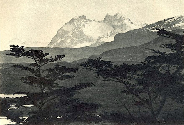
CERRO BALMACEDA PHOTOGRAPHED BY ROBERT GERSTMANN


ROBERT GERSTMANN (1896-1960), Cerro Balmaceda  (2,035 m  - 6,677 ft) Chile  In "Cerro Balmaceda",  glass plate, 1932, University of Antofagasta.

ROBERT GERSTMANN (1896-1960)
Cerro Balmaceda  (2,035 m  - 6,677 ft)
Chile

In "Cerro Balmaceda",  glass plate, 1932, University of Antofagasta.


The photographer
Robert Gerstmann was a photographer very famous in South America. Gerstmann was a Vienna born electrical engineer who, as a young man, developed an interest in photography. In 1924, he immigrated to Chile and from there traveled to Bolivia, where he made some 5000 photographs, a selection of which appear as photogravures in his Bolivia, 150 Grabados en Cobre (1928), which was reissued in 1996 by the Fundación Quipus in La Paz. Gerstmann ranged far, photographing the altiplano from La Paz south to the Argentine border, west to the Chilean border, and east to the Yungas, Cochabamba, Santa Cruz, and the lowlands along the Ríos Beni and Mamoré. Only Tarija and the Chaco escaped his lens. Five of his photographs illustrate Stewart E. McMillan's "The Heart of Aymara Land" National Geographic Magazine (February 1927), and several appear in Gustavo-Adolfo Otero's Bolivia (Guía Sinóptica) 1929. Gerstmann settled in Santiago in 1929. He published other photo albums, including Chile: 280 grabados en cobre (1932), Colombia: 200 grabados en cobre (1951), and Chile en 110 cuadros (1960?), and dabbled in film-making in Bolivia. He is thought to have died in Santiago ca. 1960. Several thousand of his glass plates are said to be at a university in Antofagasta.


The mountain
Cerro Balmaceda (2,035 m - 6,677 ft) is a heavily glaciated mountain located in the Magallanes Region of Chile. It stands at the head of Última Esperanza Sound, in the south portion of Bernardo O'Higgins National Park and near the mouth of the Serrano River. The glaciers Balmaceda and Serrano mantle the slopes of the mount.  In its vicinity is Torres del Paine National Park.
_______________________________
2022 - Wandering Vertexes...
by Francis Rousseau

Sunday, March 21, 2021

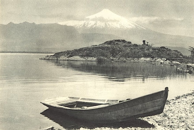
VOLCÀN ORSONO PHOTOGRAPHED BY ROBERT GERSTMANN


https://wanderingvertexes.blogspot.com/2021/03/volcan-orsono-photographed-by-robert.html

ROBERT GERSTMANN (1896-1960)
Volcàn Orsono (2,652 m - 8700 ft)
Chile

in Lago Villarrica e Volcan Orsono, photo, 1932


The volcano
The Osorno is a stratovolcano located between the province of Osorno and that of Llanquihue, in the Lakes region of Chile. At an altitude of 2,652 meters, it is the most active volcano in the southern Chilean Andes.  It rises to the east of Lake Llanquihue, known worldwide as a symbol of the local landscape. The volcano also dominates Lake Todos los Santos. Its last eruption dates from 1869. Charles Darwin saw the Osorno from afar on his second voyage on HMS Beagle and witnessed its eruption1 in January 18352. Its first ascent was made in 1848 by Jean Renous.

The photographer
Robert Gerstmann was a photographer very famous in South America. Gerstmann was a Vienna born electrical engineer who, as a young man, developed an interest in photography. In 1924, he immigrated to Chile and from there traveled to Bolivia, where he made some 5000 photographs, a selection of which appear as photogravures in his Bolivia, 150 Grabados en Cobre (1928), which was reissued in 1996 by the Fundación Quipus in La Paz. Gerstmann ranged far, photographing the altiplano from La Paz south to the Argentine border, west to the Chilean border, and east to the Yungas, Cochabamba, Santa Cruz, and the lowlands along the Ríos Beni and Mamoré. Only Tarija and the Chaco escaped his lens. Five of his photographs illustrate Stewart E. McMillan's "The Heart of Aymara Land" National Geographic Magazine (February 1927), and several appear in Gustavo-Adolfo Otero's Bolivia (Guía Sinóptica) 1929. Gerstmann settled in Santiago in 1929. He published other photo albums, including Chile: 280 grabados en cobre (1932), Colombia: 200 grabados en cobre (1951), and Chile en 110 cuadros (1960?), and dabbled in film-making in Bolivia. He is thought to have died in Santiago ca. 1960. Several thousand of his glass plates are said to be at a university in Antofagasta. 


_______________________________
2021 - Wandering Vertexes...
by Francis Rousseau

Wednesday, May 12, 2021

VOLCAN PUNTIAGUDO PHOTOGRAPHED IN 1932 BY ROBERT GERSTMANN

ROBERT GERSTMANN (1896-1960) Volcàn Puntiagudo (2, 493 m - 8, 179ft) Chile  In Volcàn Puntiagudo, photograph,1932, Photographer

ROBERT GERSTMANN (1896-1960)
Volcàn Puntiagudo (2, 493 m - 8, 179ft)
Chile

In Volcàn Puntiagudo, photograph,1932, Private collection


The volcano
Volcàn Puntiagudo (2, 493 m - 8, 179ft) also called Cerro Cenizas or Cerro Puntiagudo is a volcano in Chile remarkable for its volcanic chimney released by erosion and forming a summit neck. Puntiagudo is located in central Chile, in the Andes mountain range, between the Rupanco lakes to the north and Todos Los Santos to the south. Administratively, it is located on the border between the provinces of Llanquihue and Osorno of the Region of Lakes. Puntiagudo is an andesitic stratovolcano whose flanks have been eroded by glaciers, especially in their upper par1. Its summit is thus made up of a neck by the release of the volcanic chimney. This physiognomy makes it resemble Corcovado, another Chilean volcano located further south. Cordón Cenizos is a group of fissures and volcanic cones, stretches from Puntiagudo to the northeast. Puntiagudo began to be built at the end of the Pleistocene. However, its last eruption occurred on an unknown date.


The photographer
Robert Gerstmann was a photographer very famous in South America. Gerstmann was a Vienna born electrical engineer who, as a young man, developed an interest in photography. In 1924, he immigrated to Chile and from there traveled to Bolivia, where he made some 5000 photographs, a selection of which appear as photogravures in his Bolivia, 150 Grabados en Cobre (1928), which was reissued in 1996 by the Fundación Quipus in La Paz. Gerstmann ranged far, photographing the altiplano from La Paz south to the Argentine border, west to the Chilean border, and east to the Yungas, Cochabamba, Santa Cruz, and the lowlands along the Ríos Beni and Mamoré. Only Tarija and the Chaco escaped his lens. Five of his photographs illustrate Stewart E. McMillan's "The Heart of Aymara Land" National Geographic Magazine (February 1927), and several appear in Gustavo-Adolfo Otero's Bolivia (Guía Sinóptica) 1929. Gerstmann settled in Santiago in 1929. He published other photo albums, including Chile: 280 grabados en cobre (1932), Colombia: 200 grabados en cobre (1951), and Chile en 110 cuadros (1960?), and dabbled in film-making in Bolivia. He is thought to have died in Santiago ca. 1960. Several thousand of his glass plates are said to be at a university in Antofagasta.

_______________________________
2021 - Wandering Vertexes...
by Francis Rousseau

Friday, March 29, 2019

PARINACOTA AND POMERAPE BY RAMOS CATALAN


RAMOS CATALAN (1888-1961)
El Parinacota  (6,380 m (20,930 ft)
El Pomerape (6,282 m -20,610 ft) 
Chile - Bolivia border 

The mountains
El Parinacota  (6,380 m (20,930 ft) or Parina Quta or Parinaquta is a dormant stratovolcano on the border of Chile and Bolivia. Together with Pomerape it forms the Nevados de Payachata volcanic chain. Part of the Central Volcanic Zone of the Andes, its summit reaches an elevation of 6,380 metres (20,930 ft) above sea level. The symmetrical cone is capped by a summit crater with widths of 1 kilometre (0.62 mi) or 500 metres (1,600 ft). Farther down on the southern slopes lie three parasitic centres known as the Ajata cones. These cones have generated lava flows. The volcano overlies a platform formed by lava domes and andesitic lava flows.
The volcano started growing during the Pleistocene and formed a large cone. At some point between the Pleistocene and the Holocene, the western flank of the volcano collapsed, generating a giant landslide that spread west and formed a large, hummocky landslide deposit. The avalanche crossed and dammed a previously existing drainage, impounding or enlarging Lake Chungará; numerous other lakes now forming the headwaters of the Rio Lauca sprang up within the deposit. Volcanic activity rebuilt the cone after the collapse, cancelling out the collapse scar.
Parinacota had numerous effusive and explosive eruptions during the Holocene, the latest about 200 years ago. While there are no recorded eruptions, legends of the local Aymara people imply that they may have witnessed one eruption. Renewed activity at Parinacota is possible in the future, although the relatively low population density in the region would limit the amount of damage that could occur. Some towns and a regional highway between Bolivia and Chile are potentially exposed to the effects of a new eruption.
El Pomerape  (6,282 m -20,610 ft) is a stratovolcano is part of the Payachata complex of volcanoes, together with Parinacota Volcano to the south. The name "Payachata" means "twins" and refers to their appearance.  It hosts glaciers down to elevations of 5,300–5,800 metres (17,400–19,000 ft), lower on the northern slope.
Pomerape is a complex of lava domes, accompanied by lava flows which were emplaced atop of the domes.  It was active about 200,000 years ago.  The lava domes formed first and were later buried by the actual volcanic cone, which unlike the rhyolitic-dacitic domes is formed by hornblende andesite.  The "Chungará Andesites" and lava dome complex of Parinacota were laid down at this time. Pomerape is associated with an adventive vent that has erupted mafic magmas. The main cone was last active 106,000 +- 7,000 years ago, the adventive vent is dated to 205,000 ± 24,000 years ago.

The painter 
Benito Ramos Catalán (1888-1961) was a chilean  painter who used to sign "Ramos Catalan". Known for his marines and landscapes of the Andes and Chile, and most particularly for his mountains paintings. Most of them have the same title: "Mountains of Chile" or  "Mountains landscapes of Andes", making quite difficult to know which mountain was exactly depicted, in a country which has quite a lot of summits ! To add to the difficulty, he used to paint the most famous mountains of his country under very unusual angles or with proportions that do not correspond exactly to their real size... making even more difficult to recognize and identify them for experts ! That is why today, 55 years after his death, some of these mountains paintings are not clearly identified and presented, in the public sales, as 'possibly' a particular summit of Chile or Andes...
His works are in many Chilean institutions like Viña del Mar Fine Art Museum, O'Higginiano Fine Art Museum in Talca, Valparaiso Fine Art Museum, and Navy  Schools in Valparaiso and Talcahuano, Ranos.

___________________________________________
2019 - Wandering Vertexes...
by Francis Rousseau 
Wednesday, May 17, 2017

LICANCABUR PAINTED BY JOSEPH SELLENY


JOSEPH SELLENY (1824-1896)
Licancabur (5,916m - 19, 409ft)
Chile - Bolivia

In The Atacama desert, Chile, with the Licancabur volcano beyond
oil on canvas, 1858, Private collection

The Mountain
Licancabur  (5,916m - 19, 409ft) is a stratovolcano on the border between Bolivia and Chile, south of the Sairecabur volcano and west of Juriques. Part of the Andean Central Volcanic Zone, it has a prominent high cone. A 400-metre (1,300 ft) summit crater containing Licancabur Lake, a crater lake which is among the highest lakes in the world, caps the volcano. Three stages of lava flow emanate from the volcano, which formed on Pleistocene ignimbrites.
Licancabur has been active during the Holocene, after the ice ages. Although no historic eruptions of the volcano are known, lava flows extending into Laguna Verde have been dated to 13,240 ± 100 BP. The volcano has primarily erupted andesite, with small amounts of dacite and basaltic andesite.
Its climate is cold, dry and very sunny, with high levels of ultraviolet radiation.
 Licancabur is not covered by glaciers, and vegetation such as cushion plants and shrubs are found lower on its slopes. Chinchillas were formerly hunted on the volcano.
Licancabur is considered a holy mountain by the Atacameno people, related to the Cerro Quimal hill in northern Chile. Archeological sites have been found on its slopes and in the summit crater, which was possibly a prehistoric watchtower. The name "Licancabur" derives from the Kunza words used by the Atacameño people to refer to the volcano: lican ("people", or pueblo) and cábur ("mountain"); thus, "mountain of the people".
Because Licancabur is considered divine, attempts to climb it were discouraged and sometimes met by force; climbing it supposedly brought misfortune.  It is said that Licancabur would punish people who climbed it,  and the volcano is the mate of Quimal in the Cordillera Domeyko; at the solstices, the mountains overshadow one another.  According to local myth, this copulation fertilizes the earth.  Licancabur is considered "male" and a mountain of fire, in contrast to San Pedro (considered a mountain of water). The 1953 Antofagasta earthquake was considered divine retribution for an attempt to climb the mountain that year. According to legend, a golden object (most commonly a guanaco) was offered as tribute in the summit crater; human sacrifices have been reported on the volcano during the Inca pre-Columbian times.
Source:
 - Mercuria Calama

The painter 
Joseph Selleny (also Sellény) is an Austrian landscape painter, draftsman and lithographer and official illustrator. He studied at the Vienna Academy of Fine Arts and  traveled to South Tyrol, Lombardy and Venice. He obtained a scholarship from the Academy in Rome and Naples in 1854-1855. He was introduced to the Archduke Ferdinand Maximilian who appreciates his works and asks him participates, as draftsman, in the expedition of the SMS Novara which circumnavigates the world in 1857-1859, under the command of Captain v. Wüllerstorf-Urbair. In the course of this expedition he produced more than 2000 watercolors, sketches and drawings representing the landscapes and the natives encountered, which on his return were a great success.  He painted watercolor directly on a pattern, then works in his studio. In addition, he made engravings of the expedition in several newspapers of the time. He also photographs many views, at this time of the beginnings of photography which today constitute a real treasure. The publication of the report of the expedition in 21volumes further increases its notoriety, as many of the 224 illustrations of the first edition is inspired by his drawings.
Archduke Ferdinand Maximilian then invited Selleny to accompany him on his journey to North Africa, Cape Verde, the Canary Islands and Brazil. Selleny also designed landscaping projects, such as the Vienna Stadtpark (1862) or the castle of Miramare, owned by the archduke in Trieste.  In 1867, tragically enough, the Archduke  Ferdinand Maximilian was shot by the revolutionaries a few days after being crowned Emperor of Brazil.  Then, Joseph Selleny felt in deep depression and settled in South Tyrol where he painted imposing landscapes.  Suffering more or more of depression, he was taken to a nursing home in Inzersdorf, where he died at the age of fifty-one. A street in the district of Leopoldstadt in Vienna is dedicated to him.

Thursday, November 3, 2016

ATITLAN & TOLIMAN VOLCANOS BY ARTHUR P. COLEMAN (1852-1939)


ARTHUR P. COLEMAN (1852-1939)
  Atitlбn (3,535 m -11,598ft) & Tolimбn  (3,158 m -10,361ft) 
Guatemala 

In Atitlan and Tolimon seen from Lake Atitlan, 1937, watercolor, 

The mountains
Atitlбn volcano  (3,535 m - 11,598 ft)  is a large, conical, active stratovolcano adjacent to the caldera of Lake Atitlбn in the Guatemalan Highlands of the Sierra Madre de Chiapas range. It is within the Sololб Department, northern Guatemala. The volcano has been quite active historically, with more than a dozen eruptions recorded between 1469 and 1853, the date of its most recent eruption. Atitlбn is part of the Central American Volcanic Arc. The arc is a chain of volcanoes stretching along Central America formed by subduction of the Cocos Plate underneath the Caribbean Plate. This volcano is part of the Ring of Fire around the Pacific Ocean. Atitlбn is home to two particularly rare and beautiful birds that are endemic to the cloud forests of this region. The horned guan (Oreophasis derbianus) is a Pleistocene relic of the Cracidae family that persists today only in small fragments of its previous range. Its habitat is limited to cloud forests above approximately 1,650 metres (5,410 ft). This bird is the size of a turkey and the adult male has a one-inch scarlet-colored "horn" projecting straight up from the top of its head. The Cabanis's or azure-rumped tanager (Tangara cabanisi) is probably the most restricted-range species in the region. It occurs only at mid-elevations within the Sierra Madre del Sur of Chiapas, Mexico and western Guatemala. Atitlбn lies on the southern rim of the caldera, while Volcano San Pedro and Volcano Tolimбn lie within the caldera. San Pedro is the oldest of the three and seems to have stopped erupting about 40,000 years ago. Tolimбn began growing after San Pedro stopped erupting, and probably remains active, although it has not erupted in historic times. Atitlбn has developed almost entirely in the last 10,000 years and remains active, with its most recent eruption having occurred in 1853.
Tolimбn volcano  (3,158 m -10,361 ft) is located on the southern shores of Lago de Atitlбn. The volcano  was formed near the southern margin of the Pleistocene Atitlбn III caldera. The top of the volcano has a shallow crater and its flanks are covered with the thick remains of ancient lava flows that emerged from vents in the volcano's flanks. A parasitic lava dome, known as Cerro de Oro, was formed on the volcano's northern flank, which may have erupted a few thousand years ago.
San Pedro volcano  (3,020m -9,908 ft) (also named Las Yeguas) represented in the foggy background of in the Coleman painting, is the third stratovolcano on the shores of Lago de Atitlбn, in the Solol Department of northern Guatemala. At its base is the village of San Pedro La Laguna.
The first volcanic activity in the region occurred about 11 million years ago, and since then the region has seen four separate episodes of volcanic growth and caldera collapse, the most recent of which began about 1.8 million years ago and culminated in the formation of the present caldera. The lake now fills a large part of the caldera, reaching depths of up to 600 metres.
The caldera-forming eruption is known as Los Chocoyos eruption and ejected up to 300 km3 (72 cu mi) of tephra. The enormous eruption dispersed ash over an area of some 6 million kmІ: it has been detected from Florida to Ecuador, and can be used as a stratigraphic marker in both the Pacific and Atlantic oceans (known as Y-8 ash in marine deposits). A chocoyo is a type of bird which is often found nesting in the relatively soft ash layer.
On February 4, 1976, a massive earthquake (magnitude 7.5) struck Guatemala, killing more than 26,000 people. The earthquake fractured the lake bed and caused subsurface drainage from the lake, allowing the water level to drop two meters within one month

The artist 
Arthur Philemon Coleman was a Canadian a geologist, professor, minerals prospector, artist, Rockies explorer, backwoods canoeist, world traveller, scientist, popular lecturer, museum administrator, memoirist and...  one of Canada’s most beloved scientist. 
Arthur Coleman is a fine example of that rare bird, a polished amateur artist whose drawings and paintings stand comfortably beside those of many professionals. He was active during the time when sketching and painting was ceding to photography the task of recording the visible world. Although he was also a photographer, painting was, for him, both a poetic and a descriptive pursuit, a way of wrapping an artistic expression around a phenomenon he was interested in or moved by. Thus motivated, Coleman's paintings give much joy and command a good deal of respect. The more surprising, perhaps given that he used to introduced himself more as a geologist than a painter.
Coleman travelled throughout the United States for professional conferences as well as geological field work.  He visited many of the major American mountain ranges including: the American Cordillera Mountains (Washington, Oregon and California); the Sierra Nevada Mountains (California and Nevada); Yellowstone National Park (Wyoming, Montana and Idaho); and the Appalachian Mountains (eastern United States). Pleistocene glaciation had extended in Northern Europe as far south as Berlin and London and covered an area of two million square miles. Coleman also visited such countries as India, Australia, Brazil, Argentina, Scandinavia, Bolivia, New Zealand, South Africa and Uruguay. In his final years he made two expeditions to the Andes in Colombia, to mountains in Southern Mexico and to two mountains in Central America.  He achieved the first ascent of Castle Mountain in 1884, and in 1907, he was the first white man to attempt to climb Mount Robson. He made a total of eight exploratory trips to the Canadian Rockies, wholly four of them looking for the mythical giants of Hooker and Brown. 
From 1901 to 1922, he was a Professor of Geology at the University of Toronto and was Dean of the Faculty of Arts from 1919 to 1922. From 1931 to 1934, he was a geologist with the Department of Mines of the Government of Ontario. He was elected a Fellow of the Royal Society of Canada in 1900 and was its President in 1921. In 1929, he was appointed Honorary Vice-President of the Royal Canadian Geographical Society.
 "Mount Coleman" and "Coleman Glacier" in Banff National Park is named in his honor.  He was awarded the Penrose Medal in 1936.
He planned to climb "hi" mountain, "Mount Coleman"'in the Albertan Rockies, and had also prepared a trip to British Guiana, but death intervened.
He was author of:
- Reports on the Economic Geology of Ontario (1903)
- Lake Ojibway; Last of the Great Glacial Lakes (1909) 
- The Canadian Rockies: New and Old Trails (1911)
- Ice Ages, Recent and Ancient (1926), and was co-author of Elementary Geology (1922).
- The Last Million Years (1941) edited by George F. Kay

Saturday, August 14, 2021

SOUTHERN ANDES SUMMIT PAINTED BY RHOD WULFARS (bn 1979)

RHOD WULFARS (bn. 1979), Southern Andes (6,991 m - 22, 838ft), Argentina,  In "Twin", acrylic on hardboard, 2018, Private collection @rhodwulfars
 
 
RHOD WULFARS (bn. 1979)
Southern Andes (6,991 m - 22, 838ft)
Argentina

In Twin, acrylic on hardboard, 2018, Private collection @rhodwulfars


About this painting
The painter wrote: “It is not a real mountain. Most of my paintings are born from the combination of the imagination and the hours spent looking, walking and smelling them. I call them "Twins" because they are similar to those reliefs of the Argentinian Andean Coridilla called "acarreos", which are long slopes of very popular loose rock that can be easily viewed. very frequently observed. This painting is therefore that of an unknown mountain, dreamt up which sums up several, and which came out of my unconscious one afternoon when the brush gave it life in a mysterious way without my being able to explain it. "
And indeed this mountain that looks a lot like the Alpamayo in Peru is not the Alpamayo (even if it could  be the most famous South West face to be published very soon in this blog) !), any more than it is not the Cerro Poincenot, the Fitz Roy, the Cerro Torre or the Aconcagua, the highest peak in the Andes. These Twins imagined, encompassed, summarized and illustrated all these mountains at the same time. The most amazing being that they do it with a single stroke of the brushes as powerful and definitive as the rocky uplift itself.


The artist
Rhod Wulfars is a contemporary mountain painter using mainly acrylic technique for his paintings.
He was born in 1979 in Mendoza (Argentina). In his website he wrote: "I have spent my whole life by the mountains. On day I started to paint them". Using, in the manner of Nicolas de Staël, a style always beetween abstract and figurative, his very strong and very moving paintings described perfectly the majesty and the spectacular contents of the peaks he paints. Rhod Wulfars makes a surprising use of acrylic medium, in thick paste as one could do with oil paint. He used to named his works only bu numbers, and series letters, but sometime he writes the name of the peaks ans makes it more easy to identify. Other works by this artist on his website : rhodwulfars.wixsite.com/rhodwulfars/

The mountains
The Andes, Andes Mountains or Andean Mountains (Cordillera de los Andes in Spanish ) are the longest continental mountain range in the world, forming a continuous highland along the western edge of South America. The range is 7,000 km (4,350 mi) long, 200 to 700 km (124 to 435 mi) wide (widest between 18°S - 20°S latitude), and has an average height of about 4,000 m (13,123 ft). The Andes extend from north to south through seven South American countries: Venezuela, Colombia, Ecuador, Peru, Bolivia, Chile, and Argentina.
The Andes Mountains are the highest mountain range outside Asia. The highest mountain outside Asia, Argentina's Mount Aconcagua, rises to an elevation of about 6,961 m (22,838 ft) above sea level. The peak of Chimborazo in the Ecuadorian Andes is farther from the Earth's center than any other location on the Earth's surface, due to the equatorial bulge resulting from the Earth's rotation. The world's highest volcanoes are in the Andes, including Ojos del Salado on the Chile-Argentina border, which rises to 6,893 m (22,615 ft).
The Andes are also part of the American Cordillera, a chain of mountain ranges (cordillera) that consists of an almost continuous sequence of mountain ranges that form the western "backbone" of North America, Central America, South America and Antarctica.

___________________________________________

2021 - Wandering Vertexes...
by Francis Rousseau
Tuesday, December 4, 2018

MOUNT BALL PAINTED BY ARTHUR P. COLEMAN


ARTHUR P. COLEMAN (1852-1939)
Mount Ball  (3,311 m - 10,863 ft) 
Canada (Alberta)

The mountain 
Mount Ball is a mountain located on the Continental Divide, on the borders of Banff and Kootenay national parks in Canada. Mt. Ball is the highest peak of the Ball Range in the Canadian Rockies.
The mountain was named in 1858 by James Hector after John Ball, a politician who helped secure funding for the Palliser Expedition.  Mount Ball was first climbed in 1904 by J.D. Patterson, guided by Christian & Hans Kaufmann. The name was officially adopted in 1924 based on Palliser's 1863 map of British North America. Mt. Ball can be ascended from a scrambling route by late summer but involves remote bushwhacking, which limits the number of attempts per year. The trailhead is located at the Marble Canyon Campground in Kootenay National Park.

The painter 
Arthur Philemon Coleman was a Canadian a geologist, professor, minerals prospector, artist, Rockies explorer, backwoods canoeist, world traveller, scientist, popular lecturer, museum administrator, memoirist and...  one of Canada’s most beloved scientist.
Arthur Coleman is a fine example of that rare bird, a polished amateur artist whose drawings and paintings stand comfortably beside those of many professionals. He was active during the time when sketching and painting was ceding to photography the task of recording the visible world. Although he was also a photographer, painting was, for him, both a poetic and a descriptive pursuit, a way of wrapping an artistic expression around a phenomenon he was interested in or moved by. Thus motivated, Coleman's paintings give much joy and command a good deal of respect. The more surprising, perhaps given that he used to introduced himself more as a geologist than a painter.
Coleman travelled throughout the United States for professional conferences as well as geological field work.  He visited many of the major American mountain ranges including: the American Cordillera Mountains (Washington, Oregon and California); the Sierra Nevada Mountains (California and Nevada); Yellowstone National Park (Wyoming, Montana and Idaho); and the Appalachian Mountains (eastern United States). Pleistocene glaciation had extended in Northern Europe as far south as Berlin and London and covered an area of two million square miles. Coleman also visited such countries as India, Australia, Brazil, Argentina, Scandinavia, Bolivia, New Zealand, South Africa and Uruguay. In his final years he made two expeditions to the Andes in Colombia, to mountains in Southern Mexico and to two mountains in Central America.  He achieved the first ascent of Castle Mountain in 1884, and in 1907, he was the first white man to attempt to climb Mount Robson. He made a total of eight exploratory trips to the Canadian Rockies, wholly four of them looking for the mythical giants of Hooker and Brown.
 "Mount Coleman" and "Coleman Glacier" in Banff National Park are named in his honor. 
He was awarded the Penrose Medal in 1936.

_______________________________
 
2018 - Wandering Vertexes...
by Francis Rousseau 

Monday, September 27, 2021

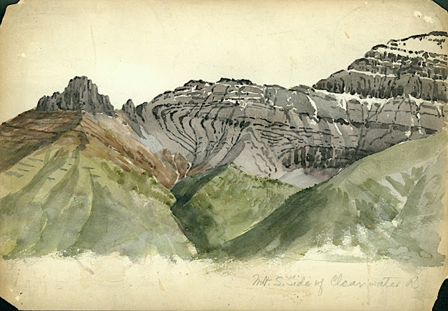
CLYDE PEAK PAINTED BY ARTHUR P. COLEMAN


ARTHUR P. COLEMAN (1852-1939), Clyde Peak (2,624 m - 8,610 f) United States of America (Montana)  In Mountain South Clide, watercolor on paper, 1895 A.P Coleman Funds.


ARTHUR P. COLEMAN (1852-1939)
Clyde Peak (2,624 m - 8,610 ft)
United States of America (Montana)

In Mountain South Clide, watercolor on paper, 1895 A.P Coleman Funds.


The mountain
Clyde Peak 2,624 m- is an 8,610 ft) is  located in Glacier National Park in the U.S. state of Montana. The mountain straddles the border shared by Flathead County and Glacier County. It is situated on the Continental Divide so precipitation runoff from the west side of the mountain drains into Thompson Creek which is part of the Middle Fork Flathead Riverwatershed, and the east side drains into headwaters of Red Eagle Creek, which flows to Red Eagle Lake, thence Saint Mary Lake. It is set in the Lewis Range, and the nearest higher neighbor is Mount Logan 1.44 mile to the northwest. Topographic relief is significant as the southwest aspect rises approximately 4,000 feet (1,220 meters) in one mile.
The mountain's name commemorates Norman Clyde (1885–1972), who made the first ascent of this peak on July 23, 1923.  Clyde is credited with 130 first ascents, most of which were in the Sierra Nevada of California.[ In 1923 he spent 36 days in Glacier National Park, Montana, where he climbed 36 mountains, including 11 first ascents.


The painter
Arthur Philemon Coleman was a Canadian a geologist, professor, minerals prospector, artist, Rockies explorer, backwoods canoeist, world traveller, scientist, popular lecturer, museum administrator, memoirist and... one of Canada’s most beloved scientist.
Arthur Coleman is a fine example of that rare bird, a polished amateur artist whose drawings and paintings stand comfortably beside those of many professionals. He was active during the time when sketching and painting was ceding to photography the task of recording the visible world. Although he was also a photographer, painting was, for him, both a poetic and a descriptive pursuit, a way of wrapping an artistic expression around a phenomenon he was interested in or moved by. Thus motivated, Coleman's paintings give much joy and command a good deal of respect. The more surprising, perhaps given that he used to introduced himself more as a geologist than a painter.
Coleman travelled throughout the United States for professional conferences as well as geological field work. He visited many of the major American mountain ranges including: the American Cordillera Mountains (Washington, Oregon and California); the Sierra Nevada Mountains (California and Nevada); Yellowstone National Park (Wyoming, Montana and Idaho); and the Appalachian Mountains (eastern United States). Pleistocene glaciation had extended in Northern Europe as far south as Berlin and London and covered an area of two million square miles. Coleman also visited such countries as India, Australia, Brazil, Argentina, Scandinavia, Bolivia, New Zealand, South Africa and Uruguay. In his final years he made two expeditions to the Andes in Colombia, to mountains in Southern Mexico and to two mountains in Central America. He achieved the first ascent of Castle Mountain in 1884, and in 1907, he was the first white man to attempt to climb Mount Robson. He made a total of eight exploratory trips to the Canadian Rockies, wholly four of them looking for the mythical giants of Hooker and Brown.
From 1901 to 1922, he was a Professor of Geology at the University of Toronto and was Dean of the Faculty of Arts from 1919 to 1922. From 1931 to 1934, he was a geologist with the Department of Mines of the Government of Ontario. He was elected a Fellow of the Royal Society of Canada in 1900 and was its President in 1921. In 1929, he was appointed Honorary Vice-President of the Royal Canadian Geographical Society.
"Mount Coleman" and "Coleman Glacier" in Banff National Park is named in his honor. He was awarded the Penrose Medal in 1936.
He planned to climb "his" mountain, "Mount Coleman"'in the Albertan Rockies, and had also prepared a trip to British Guiana, but death intervened.
He was author of:
- Reports on the Economic Geology of Ontario (1903)
- Lake Ojibway; Last of the Great Glacial Lakes (1909)
- The Canadian Rockies: New and Old Trails (1911)
- Ice Ages, Recent and Ancient (1926), and was co-author of Elementary Geology (1922).
- The Last Million Years (1941) edited by George F. Kay

 
___________________________________________
2021 - Wandering Vertexes...
by Francis Rousseau

Sunday, March 31, 2019

SURPRISE MOUNTAIN BY ARTHUR. P. COLEMAN


ARTHUR P. COLEMAN (1852-1939)
Surprise Mountain  (1,929m - 63,30ft) 
United States of America (Washington State) 

In Surprize Mountain, Showing Thalkessel, left side in shade, watercolor 

The mountain 
Surprise Mountain  (1,929m - 63,30ft) is an alpine peak nestled in the middle of the Alpine Lakes Wilderness of Washington State. Perhaps appropriately, several alpine lakes are found near the mountain. The Deception Lakes are located at the south end of the mountain, and Glacier Lake and Surprise Lake are located northeast of the mountain. Views of surrounding peaks and valleys from the mountain are also far-reaching, including Mount Daniel and Glacier Peak. Surprise Mountain is located southeast of Spark Plug Mountain and southwest of Thunder Mountain.
In 1932, the U.S. Forest Service built a L-4 cab fire lookout on the summit of Surprise Mountain, due to its wide views of the Central Cascade Mountains. The U.S. Forest Service then decommissioned and destroyed the fire lookout during the 1950s. The only remnant of the lookout that remains today is a tall metallic pole at the mountain summit.

The painter 
Arthur Philemon Coleman was a Canadian a geologist, professor, minerals prospector, artist, Rockies explorer, backwoods canoeist, world traveller, scientist, popular lecturer, museum administrator, memoirist and...  one of Canada’s most beloved scientist.
Arthur Coleman is a fine example of that rare bird, a polished amateur artist whose drawings and paintings stand comfortably beside those of many professionals. He was active during the time when sketching and painting was ceding to photography the task of recording the visible world. Although he was also a photographer, painting was, for him, both a poetic and a descriptive pursuit, a way of wrapping an artistic expression around a phenomenon he was interested in or moved by. Thus motivated, Coleman's paintings give much joy and command a good deal of respect. The more surprising, perhaps given that he used to introduced himself more as a geologist than a painter.
Coleman travelled throughout the United States for professional conferences as well as geological field work.  He visited many of the major American mountain ranges including: the American Cordillera Mountains (Washington, Oregon and California); the Sierra Nevada Mountains (California and Nevada); Yellowstone National Park (Wyoming, Montana and Idaho); and the Appalachian Mountains (eastern United States). Pleistocene glaciation had extended in Northern Europe as far south as Berlin and London and covered an area of two million square miles. Coleman also visited such countries as India, Australia, Brazil, Argentina, Scandinavia, Bolivia, New Zealand, South Africa and Uruguay. In his final years he made two expeditions to the Andes in Colombia, to mountains in Southern Mexico and to two mountains in Central America.  He achieved the first ascent of Castle Mountain in 1884, and in 1907, he was the first white man to attempt to climb Mount Robson. He made a total of eight exploratory trips to the Canadian Rockies, wholly four of them looking for the mythical giants of Hooker and Brown.
 "Mount Coleman" and "Coleman Glacier" in Banff National Park are named in his honor.
He was awarded the Penrose Medal in 1936.

_______________________________
2019 - Wandering Vertexes...
by Francis Rousseau 


Friday, February 16, 2024

VOLCÀN SAN JOSÉ   PHOTOGRAPHIÉ PAR   ROBERT GERSTMANN


ROBERT GERSTMANN (1896-1960) Volcán San José (5,856m) Chili - Argentine  Photographié en 1932 à bord d'un aéroplane


ROBERT GERSTMANN (1896-1960)
Volcán San José (5,856m)
Chili - Argentine

Photographié en 1932 à bord d'un aéroplane

 Le volcan
Le San José (5 856 mètres) est un volcan des Andes centrales d'Argentine (province de Mendoza, Tunuyán) et du Chili (Région métropolitaine de Santiago).
Il est situé à 40 kilomètres au sud du volcan Tupungato, à quelque 80 kilomètres à l'est-sud-est de Santiago du Chili, et à 80 kilomètres à l'ouest de la ville argentine de San Carlos.
Son altitude est de (sommet sud-oriental) et 5 820 mètres (sommet sud-occidental).
Le volcan comporte plusieurs sommets secondaires. La première ascension du sommet nord du San José date de l'année 1920 (5 740 mètres). C'est en 1931, qu'Otto Pfnninger et Sebastián Krückel surmontèrent le sommet principal (sommet sud-est). Ils furent surpris de découvrir l'importance du cratère et des glaciers qui occupaient l'intérieur de ce dernier.
À 3 130 mètres d'altitude se trouve le refuge refugio Plantat, qui fut édifié en par Enrique Plantat en 1937, utilisant les plans d'un refuge déjà existant dans les Alpes. Au début, il était pourvu d'eau potable et de chauffage ainsi que d'autres commodités, mais il s'est dégradé faute d'entretien.
Lorsqu'on aborde le volcan du côté chilien, près de la localité de San Gabriel, il surprend par son énorme taille et contribue à impressionner les touristes.

Le photographe
Robert Gerstmann fut un photographe très connu en Amérique du Sud. Gerstmann était un ingénieur électricien né à Vienne qui, dans sa jeunesse, développa un intérêt pour la photographie. En 1924, il immigre au Chili et de là se rend en Bolivie, où il réalise quelque 5 000 photographies, dont une sélection apparaît sous forme de photogravures dans son Bolivie, 150 Grabados en Cobre (1928), réédité en 1996 par la Fundación Quipus en La Paz. Gerstmann a parcouru de longues distances, photographiant l'altiplano de La Paz au sud jusqu'à la frontière argentine, à l'ouest jusqu'à la frontière chilienne et à l'est jusqu'aux Yungas, Cochabamba, Santa Cruz et les basses terres le long des Ríos Beni et Mamoré. Seuls Tarija et le Chaco ont échappé à son objectif. Cinq de ses photographies illustrent le magazine National Geographic "The Heart of Aymara Land" de Stewart E. McMillan (février 1927), et plusieurs apparaissent dans Bolivia (Guía Sinóptica) 1929 de Gustavo-Adolfo Otero. Gerstmann s'installe à Santiago en 1929. Il publie d'autres photos. albums, dont Chili : 280 grabados en cobre (1932), Colombie : 200 grabados en cobre (1951) et Chili en 110 cuadros (1960 ?), et s'est essayé au cinéma en Bolivie. On pense qu'il est mort à Santiago ca. 1960. Plusieurs milliers de ses plaques de verre se trouveraient dans une université d'Antofagasta.

 ________________________________________

2011-2024 - Gravir les montagnes en peinture
Un blog de Francis Rousseau

Sunday, January 12, 2020

MOUNT CAUBVICK/ MONT D'IBERVILLE PAINTED BY ARTHUR P. COLEMAN


ARTHUR P. COLEMAN (1852-1939)
Mount Caubvick / Mont D'Iberville (1,652 m -5,420 ft) 
Canada (Labrador /Quebec border) 

In Mountains South of Nakvak, Labrador; oil on canvas, 1910, Private collection

The mountain 
Mount Caubvick / Mont D'Iberville (1,652 m -5,420 ft)  is a mountain located in Canada on the border between Labrador and Quebec in the Selamiut Range of the Torngat Mountains. Mount Caubvick is the highest point in mainland Canada east of the Rockies. The mountain contains a massive peak that rises sharply from nearby sea level. Craggy ridges, steep cirques and glaciers are prominent features of the peak.
The alp was named Mont d'Iberville by the Quebec government in 1971. It remained nameless on the Labrador side for several years; it became known unofficially as L1, L for Labrador and 1 for highest. In 1981, at the suggestion of Dr. Peter Neary, the provincial government named the mountain after Caubvick, one of the five Inuit who accompanied George Cartwright to England in 1772.
Mount Caubvick also hosts the highest point in both the province of Newfoundland and Labrador and Quebec, although the summit itself lies about 10 metres (33 ft) northeast of the Quebec provincial border and is entirely within Labrador.

The painter
Arthur Philemon Coleman was a Canadian a geologist, professor, minerals prospector, artist, Rockies explorer, backwoods canoeist, world traveller, scientist, popular lecturer, museum administrator, memoirist and... one of Canada’s most beloved scientist.
Arthur Coleman is a fine example of that rare bird, a polished amateur artist whose drawings and paintings stand comfortably beside those of many professionals. He was active during the time when sketching and painting was ceding to photography the task of recording the visible world. Although he was also a photographer, painting was, for him, both a poetic and a descriptive pursuit, a way of wrapping an artistic expression around a phenomenon he was interested in or moved by. Thus motivated, Coleman's paintings give much joy and command a good deal of respect. The more surprising, perhaps given that he used to introduced himself more as a geologist than a painter.
Coleman travelled throughout the United States for professional conferences as well as geological field work. He visited many of the major American mountain ranges including: the American Cordillera Mountains (Washington, Oregon and California); the Sierra Nevada Mountains (California and Nevada); Yellowstone National Park (Wyoming, Montana and Idaho); and the Appalachian Mountains (eastern United States). Pleistocene glaciation had extended in Northern Europe as far south as Berlin and London and covered an area of two million square miles. Coleman also visited such countries as India, Australia, Brazil, Argentina, Scandinavia, Bolivia, New Zealand, South Africa and Uruguay. In his final years he made two expeditions to the Andes in Colombia, to mountains in Southern Mexico and to two mountains in Central America. He achieved the first ascent of Castle Mountain in 1884, and in 1907, he was the first white man to attempt to climb Mount Robson. He made a total of eight exploratory trips to the Canadian Rockies, wholly four of them looking for the mythical giants of Hooker and Brown.
"Mount Coleman" and "Coleman Glacier" in Banff National Park are named in his honor.
He was awarded the Penrose Medal in 1936.

_______________________________

2020 - Wandering Vertexes...
by Francis Rousseau

Monday, February 27, 2017

MACHU PICCHU BY HIRAM BINGHAM III


 HIRAM BINGHAM III (1875-1956) 
Machu Picchu (2,430 m -7,970 ft) 
Peru

Photo made in 1912 - original ruins before modern reconstruction 

The mountain and site 
Machu Picchu  is a 15th-century Inca citadel situated on a mountain ridge 2,430 m -7,970 ft above sea level. It is located in the Cusco Region, Urubamba Province, Machupicchu District in Peru, above the Sacred Valley, which is 80 kilometres (50 mi) northwest of Cuzco and through which the Urubamba River flows. Machu Picchu lies in the southern hemisphere, 13.164 degrees south of the equator. It is 80 kilometres (50 miles) northwest of Cusco, on the crest of the mountain Machu Picchu, located about 2,430 m-7,970 feet above mean sea level, over 1,000 m-3,300 ft lower than Cusco, which has an elevation of (3,600 m -11,800 ft. As such, it had a milder climate than the Inca capital. It is one of the most important archaeological sites in South America, one of the most visited tourist attractions in Latin America  and the most visited in Peru.
The city sits in a saddle between the two mountains Machu Picchu and Huayna Picchu, with a commanding view down two valleys and a nearly impassable mountain at its back.
Most archaeologists believe that Machu Picchu was built as an estate for the Inca emperor Pachacuti (1438–1472). Often mistakenly referred to as the "Lost City of the Incas" (a title more accurately applied to Vilcabamba), it is the most familiar icon of Inca civilization. The Incas built the estate around 1450 but abandoned it a century later at the time of the Spanish Conquest. Although known locally, it was not known to the Spanish during the colonial period and remained unknown to the outside world until American historian Hiram Bingham brought it to international attention in 1911.
Machu Picchu was built in the classical Inca style, with polished dry-stone walls. Its three primary structures are the Inti Watana, the Temple of the Sun, and the Room of the Three Windows. Most of the outlying buildings have been reconstructed in order to give tourists a better idea of how they originally appeared. By 1976, thirty percent of Machu Picchu had been restored[4] and restoration continues. Machu Picchu was declared a Peruvian Historical Sanctuary in 1981 and a UNESCO World Heritage Site in 1983. In 2007, Machu Picchu was voted one of the New Seven Wonders of the World in a worldwide Internet poll.

The photographer - explorer
Hiram Bingham III was an American academic, explorer and politician. He made public the existence of the Inca citadel of Machu Picchu in 1911 with the guidance of local indigenous farmers. Later, Bingham served as a member of the United States Senate for the state of Connecticut.
Bingham was not a trained archaeologist. Yet, it was during Bingham's time as a lecturer – later professor – in South American history at Yale that he re-discovered the largely forgotten Inca city of Machu Picchu. In 1908, he had served as delegate to the First Pan American Scientific Congress at Santiago, Chile. On his way home via Peru, a local prefect convinced him to visit the pre-Columbian city of Choquequirao. Bingham published an account of this trip in Across South America; an account of a journey from Buenos Aires to Lima by way of Potosí, with notes on Brazil, Argentina, Bolivia, Chile, and Peru.
Bingham was thrilled by the prospect of unexplored Inca cities, and organized the 1911 Yale Peruvian Expedition with one of its objectives to search for the last capital of the Incas. On July 24, 1911, Melchor Arteaga led Bingham to Machu Picchu, which had been largely forgotten by everybody except the small number of people living in the immediate valley, possibly including two local missionaries named Thomas Payne and Stuart McNairn whose are supposed to have already climbed to the ruins in 1906. Also the Cusco explorers Enrique Palma, Gabino Sanchez and Agustín Lizarraga are said to have arrived at the site in 1901. Bingham returned to Peru in 1912, 1914 and 1915 with the support of Yale and the National Geographic Society. In The Lost City of the Incas (1948), a bestseller upon its publication in 1948, Bingham related how he came to believe that Machu Picchu housed a major religious shrine and served as a training center for religious leaders. Modern archaeological research has since determined that the site was not a religious center but a royal estate to which Inca leaders and their entourage repaired during the Andean summer.
Machu Picchu has become one of the major tourist attractions in South America, and Bingham is recognized as the man who brought the site to world attention, although many others helped to bring this site into the public eye. The switchback-filled road that carries tourist buses to the site from the Urubamba River is called the Hiram Bingham Highway.
Bingham has been cited as one possible basis for the "Indiana Jones" character.
Peru has long sought the return of the estimated 40,000 artifacts, including mummies, ceramics and bones, that Bingham had excavated and exported from the Machu Picchu site. On September 14, 2007, an agreement was made between Yale University and the Peruvian government for the return of the objects. On April 12, 2008, the Peruvian government stated that it had revised previous estimates of 4,000 pieces up to 40,000.

Tuesday, November 26, 2019

MOUNT ROBSON BY ARTHUR P. COLEMAN


ARTHUR P. COLEMAN (1852-1939)
Mount Robson (3,954 m - 12, 972 ft) 
Canada (British Columbia)

  In Mount Robson glacier -cutting steps, oil on canvas


The mountain 
Mount Robson (3,954 m - 12, 972 ft) is the most prominent mountain in North America's Rocky Mountain range; it is also the highest point in the Canadian Rockies. The mountain is located entirely within Mount Robson Provincial Park of British Columbia, and is part of the Rainbow Range. Mount Robson is the second highest peak entirely in British Columbia, behind Mount Waddington in the Coast Range. The south face of Mount Robson is clearly visible from the Yellowhead Highway (Highway 16), and is commonly photographed along this route.
Mount Robson was likely named after Colin Robertson, who worked for both the North West Company and the Hudson’s Bay Company at various times in the early 19th century, though there was confusion over the name as many assumed it to have been named for John Robson, an early premier of British Columbia. The Texqakallt, a Secwepemc people and the earliest inhabitants of the area, call it Yuh-hai-has-kun (The Mountain of the Spiral Road). Other unofficial names include Cloud Cap Mountain.
In 1893, five years after the expedition of A.P. Coleman to Athabasca Pass and the final settling of the mistaken elevations of Mt. Hooker and Mt. Brown, Mt. Robson was first surveyed by James McEvoy and determined to be the highest peak in the Canadian Rockies. The first documented ascent of Mount Robson, led by the young guide Conrad Kain, at its time the hardest ice face to be climbed on the continent, was achieved during the 1913 annual expedition organized by a large party of Alpine Club of Canada members who made use of the newly completed Grand Trunk Pacific railway to access the area. Prior to 1913, it had been necessary to approach the mountain by pack train from Edmonton or Laggan via Jasper and Lucerne, so only few intrepid explorers had made previous attempts at exploring the mountain. The most famous early ascensionist was the Reverend George Kinney, a founding member of the Alpine Club, who on his twelfth attempt in August 1909 claimed to have reached the summit with local outfitter Donald "Curly" Phillips. A major controversy over this claim and over the implausible nature of his unlikely and dangerous route dominated the discourse within the Alpine Club elite, and he is now generally presumed to have reached the high summit ridge before being turned back at the final ice dome of the peak. Kinney Lake, below the south face, is named in his honour.
The north face of Mount Robson is heavily glaciated and 800 m (2,600 ft) of ice extends from the summit to Berg Glacier. The Berg glacier calves directly into the lake. The Robson Glacier, which fills the cirque and valley between Mount Robson and Mount Resplendent, in the early 1900s fed directly into both Berg lake and Adolphus lake, straddling the Continental Divide and draining thus to both the Arctic and Pacific oceans via the Smoky and Robson Rivers, respectively. It since has receded more than 2 kilometres and is the source of the Robson River only.

The painter 
Arthur Philemon Coleman was a Canadian a geologist, professor, minerals prospector, artist, Rockies explorer, backwoods canoeist, world traveller, scientist, popular lecturer, museum administrator, memoirist and...  one of Canada’s most beloved scientist.
Arthur Coleman is a fine example of that rare bird, a polished amateur artist whose drawings and paintings stand comfortably beside those of many professionals. He was active during the time when sketching and painting was ceding to photography the task of recording the visible world. Although he was also a photographer, painting was, for him, both a poetic and a descriptive pursuit, a way of wrapping an artistic expression around a phenomenon he was interested in or moved by. Thus motivated, Coleman's paintings give much joy and command a good deal of respect. The more surprising, perhaps given that he used to introduced himself more as a geologist than a painter.
Coleman travelled throughout the United States for professional conferences as well as geological field work.  He visited many of the major American mountain ranges including: the American Cordillera Mountains (Washington, Oregon and California); the Sierra Nevada Mountains (California and Nevada); Yellowstone National Park (Wyoming, Montana and Idaho); and the Appalachian Mountains (eastern United States). Pleistocene glaciation had extended in Northern Europe as far south as Berlin and London and covered an area of two million square miles. Coleman also visited such countries as India, Australia, Brazil, Argentina, Scandinavia, Bolivia, New Zealand, South Africa and Uruguay. In his final years he made two expeditions to the Andes in Colombia, to mountains in Southern Mexico and to two mountains in Central America.  He achieved the first ascent of Castle Mountain in 1884, and in 1907, he was the first white man to attempt to climb Mount Robson. He made a total of eight exploratory trips to the Canadian Rockies, wholly four of them looking for the mythical giants of Hooker and Brown.
 "Mount Coleman" and "Coleman Glacier" in Banff National Park are named in his honor.
He was awarded the Penrose Medal in 1936.

_______________________________
2019 - Wandering Vertexes...
by Francis Rousseau 


Tuesday, September 19, 2017

MOUNT BRAZEAU BY ARTHUR. P. COLEMAN


ARTHUR P. COLEMAN (1852-1939)
Mount Brazeau (3, 500 m - 11, 483 ft) 
Canada (Alberta) 

 In The Brazeau from camp 17, 1892 watercolor 

The mountain 
Mount Brazeau  (3, 470m - 11, 380ft)  is a mountain in  Canada (Alberta),  located in the upper Coronet Creek Valley of Jasper National Park. It stands west of the Coronet Glacier and south of Maligne Lake. The mountain was named in 1902 by Arthur P. Coleman (who painted the mountain as well) after Joseph Edward Brazeau, who had provided his translation skills to the Palliser Expedition. The name Brazeau was originally applied to the Brazeau River by Sir James Hector ( the most important members of the Palliser Expedition, becoming the first to travel through much of the Canadian Rockies.) 
Mount Brazeau is an impressive mountain with several striking and formidable faces falling down to Maligne Lake and Coronet Creek in southern Jasper National Park. The West Face is massive and near vertical, rising nearly 1,000 metres (3,280 ft.) from Coronet Creek to the summit plateau, which is draped in the glacial mass of the Brazeau Icefield. The south and southwest slopes, topped with the Brazeau Icefield, are low angle and gentle, but are riddled with a minefield of hidden crevasses. 
Mount Brazeau is high on the list of Canadian Rockies 11,000 footers, depending on your perspective, either the thirteenth, seventeenth or twenty first highest mountain in the Canadian Rockies; 21 th on the generally accepted list of 54 summits. 
Jasper National Park  (11,228 square kilometres -4,335 square miles) is the largest of Canada's Rocky Mountain Parks and part of a UNESCO World Heritage Site. 

The painter 
Arthur Philemon Coleman was a Canadian a geologist, professor, minerals prospector, artist, Rockies explorer, backwoods canoeist, world traveller, scientist, popular lecturer, museum administrator, memoirist and...  one of Canada’s most beloved scientist.
Arthur Coleman is a fine example of that rare bird, a polished amateur artist whose drawings and paintings stand comfortably beside those of many professionals. He was active during the time when sketching and painting was ceding to photography the task of recording the visible world. Although he was also a photographer, painting was, for him, both a poetic and a descriptive pursuit, a way of wrapping an artistic expression around a phenomenon he was interested in or moved by. Thus motivated, Coleman's paintings give much joy and command a good deal of respect. The more surprising, perhaps given that he used to introduced himself more as a geologist than a painter.
Coleman travelled throughout the United States for professional conferences as well as geological field work.  He visited many of the major American mountain ranges including: the American Cordillera Mountains (Washington, Oregon and California); the Sierra Nevada Mountains (California and Nevada); Yellowstone National Park (Wyoming, Montana and Idaho); and the Appalachian Mountains (eastern United States). Pleistocene glaciation had extended in Northern Europe as far south as Berlin and London and covered an area of two million square miles. Coleman also visited such countries as India, Australia, Brazil, Argentina, Scandinavia, Bolivia, New Zealand, South Africa and Uruguay. In his final years he made two expeditions to the Andes in Colombia, to mountains in Southern Mexico and to two mountains in Central America.  He achieved the first ascent of Castle Mountain in 1884, and in 1907, he was the first white man to attempt to climb Mount Robson. He made a total of eight exploratory trips to the Canadian Rockies, wholly four of them looking for the mythical giants of Hooker and Brown.
From 1901 to 1922, he was a Professor of Geology at the University of Toronto and was Dean of the Faculty of Arts from 1919 to 1922. From 1931 to 1934, he was a geologist with the Department of Mines of the Government of Ontario. He was elected a Fellow of the Royal Society of Canada in 1900 and was its President in 1921. In 1929, he was appointed Honorary Vice-President of the Royal Canadian Geographical Society.
 "Mount Coleman" and "Coleman Glacier" in Banff National Park is named in his honor.  He was awarded the Penrose Medal in 1936.
He planned to climb "hi" mountain, "Mount Coleman"'in the Albertan Rockies, and had also prepared a trip to British Guiana, but death intervened.
He was author of:
- Reports on the Economic Geology of Ontario (1903)
- Lake Ojibway; Last of the Great Glacial Lakes (1909)
- The Canadian Rockies: New and Old Trails (1911)
- Ice Ages, Recent and Ancient (1926), and was co-author of Elementary Geology (1922).
- The Last Million Years (1941) edited by George F. Kay