google.com, pub-0288379932320714, DIRECT, f08c47fec0942fa0 GRAVIR LES MONTAGNES... EN PEINTURE

Sunday, August 7, 2022

LE PILON DU ROI - MASSIF DE L'ÉTOILE PAINTED BY PAUL CÉZANNE


PAUL CÉZANNE (1839-1906) The Pilon du Roi - Massif de l'Etoile (710 m - 2,200 ft) France                    La Chaine de l'Etoile avec le Pilon du Roi, 1885–1886,  Barnes Foundation


PAUL CÉZANNE (1839-1906)
The Pilon du Roi - Massif de l'Etoile (710 m - 2,200 ft)
France 

                     La Chaîne de l'Etoile avec le Pilon du Roi, 1885–1886,  Barnes Foundation


The mountain

The Massif de l'Etoile (Range of the Star) is a small mountain range located north of Marseille. Covering an area of ​​10,000 hectares, it culminates at 779 meters at Grand-Puech. Its other highest points are: to the west, the summit of Grande-Étoile (590 metres) and l'Étoile (652 metres, the highest point in the municipality of Marseilles), to the east, besides the Tête du Grand-Puech, the Mont Julien (647 meters), while the center of the massif is dominated by the Pilon du Roi (710 meters) whose name is a deformation of the Provençal Pieloun dóu Roure, or the “peak of the oak”.
With the Garlaban massif, it forms a chain of mountains in coastal limestone Lower Provence in the south of Bouches-du-Rhône. They constitute a vast natural space of approximately 20,000 hectares which emerge at the heart of an urban complex of more than one million inhabitants with the agglomerations of Marseille, Aix-en-Provence, Aubagne and Gardanne.
The massif crosses 18 communes of the Bouches-du-Rhône.
On the northern edge of the Marseille agglomeration, this massif offers a beautiful image of the non-coastal hills of limestone Basse-Provence with typical flora, including endemic and rare species, including one from Appendix II of the plant protection system. (Arenaria provincialis), a typical vegetation of coppice, scrubland, lawns and rock habitats belonging to the Meso-Mediterranean level with even, thanks to a clear shade, an outline of a supra-Mediterranean level (coppice - high oak forest pubescent holly and pine forests of Scots pine) and a Mediterranean fauna whose current studies show for the moment typicality and originality.


The Painter
If mount Sainte-Victoire appears to have been the subject of a true love story with the painter Paul Cezanne, it is not the only one mountain he painted.
Aix-en Provence (France) painter Paul Cezanne still remains closely linked to his hometown. His studio in Les Lauves remains a place to visit, as if the painter was coming back from one second to the other. But the eternal bond is undoubtedly the series of paintings he did of the Montagne Sainte-Victoire. A hobby, a passion, a thread in the painter's work that took place in the latter part of his life, between 1882 and 1906 when he died in Aix. History says that the painter had contracted a nasty pneumonia during a working session on the mountain. This is what can be called 'die on stage'.
Cézanne had a considerable influence on the art of the late nineteenth and the early twentieth century. Acknowledged master of his time, he attended during stays in Paris between 1862 and 1882, the Impressionist band: Camille Pissarro, Auguste Renoir (who also ended his life in the Provencal brightness), Claude Monet, Alfred Sisley and others. He participated in the Impressionist adventure while keeping his personality: it is the time of the shock of the en plein air, easels in the grass, looking for natural light and emotion.
The influence of the Aix painter is recognized in the history of art since it would be the cause of the Cubist movement embodied in 1906 by Pablo Picasso and Georges Braque. The first historically so called Cubist painting ' Les Demoiselles d'Avignon' would, a true artistic shock shown by Picasso in 1907 (one year after the death of Cézanne) is today one of the masterpieces of the MoMA in New York.
It is the search of volumes around which leads to the appearance of geometry in landscapes or still lifes of Cézanne.In 20 years, Cézanne pushes his style to express the emotion of the landscape, suggesting the wind, involving movement just like if we can breathe the air of the scene. In his first paintings pf the Sainte Victoire,(in the 1880’s) he expresses the giant aspect of the mountain that dominates the area with his characteristic e way of painting at the time, with a juxtaposition of linear brushstrokes and a range of soft, natural colors. In the last paintings of the Sainte Victoire, view from Les Lauves, between 1904 and 1906, he shows shots less accurate brushes allowing the shape of the mountain emerge from the canvas like an apparition. That is the whole intention of the artist, show nature as it is without fail to convey emotion.

_______________________________
2022 - Wandering Vertexes...
by Francis Rousseau

Thursday, August 4, 2022

LE MONT AGEL PAINTED BY CLAUDE MONET

CLAUDE MONET (1840-1926) Mont Agel (1,151m - 3,776 ft) France - Principauté de Monaco - Italy border  In "La Corniche near Monaco, Le Mont Agel", oil on canvas, 65 x 82cm, Private Collection


CLAUDE MONET (1840-1926)
Mont Agel (1,151m - 3,776 ft)
France - Principauté de Monaco - Italy border

In "La Corniche near Monaco, Le Mont Agel", oil on canvas, 65 x 82cm, Private Collection


About this painting
Claude  Monet  painted the Mont Agel quite a number of times, but in ecah painting colors and  general impression are totally different.  One can compare the different paintings of that mountain he done. this one is supposed to have been painted at 1the sunset.  Monet, like the japanese painters ,and particularly Hokusai who painted the 36 views of Mount Fuji, reproduced the same artistic behavior by painting series of the same mountains, in the same place, at different hours of the day or different seasons. At Cap Martin and Mont Agel, Monet painted about ten of them.

 The mountain
Mont Agel (1,151m - 3,776 ft) is a summit of the Alps located in the South of France, overlooking part of the French Riviera, Monaco, Beausoleil, Roquebrune-Cap-Martin... exactly as shwon in the Monet's painting above !
It has held a historic strategic position since Antiquity and still houses military aerial detection installations today. Mount Agel is precisely located in the French commune of Peille, ( Provence-Alpes-Côte d'Azur region). It rises in the Prealps of Nice and constitutes the highest point of the Monegasque watershed. The highest point of the principality, of Monaco, on the slopes of this mountain, can be reached by the Chemin des Révoires. A massive summit, Mount Agel is visible from a great distance: from certain districts of Nice as well as from a large part of the French Riviera between Cannes, Antibes, Nice, Antibes, and the Principality of Monaco and likewise from the Italian Riviera to around Vintimiglia and Bordighiera.
The history of Mount Agel begins with the Celto-Ligurian tribes who occupied the site and some of whose members were involved in the boarding and looting of boats engaged in cabotage. They are submitted from 23 to 13 BC. BC by the Romans who restored the old coastal route passing through the slopes of Mount Agel to link Ventimiglia to Narbonne Gaul and forming part of the Via Aurelia.
From 1931, new elements of fortification were built within the framework of the Maginot line.
Mount Agel now houses a large work of artillery equipped with turrets, linked together by deeply buried galleries. During the fighting of June 1940, his shots participated in the defense of Menton and supported the outpost of Pont-Saint-Louis and the work of Cap-Martin.
Until 2012, the 943 Capitaine Auber air base of the French Air Force was located there.
Today, only radars remain, which continue their watch in automatic mode, the information being transmitted and used by the Detection and Control Center at 942 Lyon-Mont Verdun air base.
Mount Agel also shelters on its slopes, the Monte-Carlo Golf Club, a very selective club. A little to the east of the golf course is the transmitter center of Fontbonne. Until its recent redevelopment, there were various protohistoric constructions.
Close to Mount Agel and the golf course is also the summer residence of Princes of Monaco (Rocagel site).


The painter
The painter Oscar-Claude Monet better known as Claude Monet was a founder of French Impressionist painting, and the most consistent and prolific practitioner of the movement's philosophy of expressing one's perceptions before nature, especially as applied to plein-air landscape painting. The term "Impressionism" is derived from the title of his painting « Impression, soleil levant » (Impression, Sunrise), which was exhibited in 1874 in the first of the independent exhibitions mounted by Monet and his associates as an alternative to the Salon de Paris.
Monet's ambition of documenting the French countryside led him to adopt a method of painting the same scene many times in order to capture the changing of light and the passing of the seasons exactly like the japanese artist Hokusai (1760-1849) did with his 36 views of Mount Fuji.
Monet repeated this kinf of "exercise de stylee with his series on Les Petites Dalles. and Kolsass mountain.
Monet has been described as "the driving force behind Impressionism". Crucial to the art of the Impressionist painters was the understanding of the effects of light on the local colour of objects, and the effects of the juxtaposition of colours with each other. Monet's long career as a painter was spent in the pursuit of this aim.
In 1856, his chance meeting with Eugene Boudin, a painter of small beach scenes, opened his eyes to the possibility of plein-air painting. From that time, with a short interruption for military service, he dedicated himself to searching for new and improved methods of painterly expression. To this end, as a young man, he visited the Paris Salon and familiarised himself with the works of older painters, and made friends with other young artists.[54] The five years that he spent at Argenteuil, spending much time on the River Seine in a little floating studio, were formative in his study of the effects of light and reflections. He began to think in terms of colours and shapes rather than scenes and objects. He used bright colours in dabs and dashes and squiggles of paint. Having rejected the academic teachings of Gleyre's studio, he freed himself from theory, saying "I like to paint as a bird sings."
In 1877 a series of paintings at Gare St-Lazare had Monet looking at smoke and steam and the way that they affected colour and visibility, being sometimes opaque and sometimes translucent. He was to further use this study in the painting of the effects of mist and rain on the landscape. The study of the effects of atmosphere were to evolve into a number of series of paintings in which Monet repeatedly painted the same subject in different lights, at different hours of the day, and through the changes of weather and season. This process began in the 1880s and continued until the end of his life in 1926.
His first series exhibited as such was of Haystacks, painted from different points of view and at different times of the day. Fifteen of the paintings were exhibited at the Galerie Durand-Ruel in 1891. In 1892 he produced what is probably his best-known series, Twenty-six views of Rouen Cathedral. In these paintings Monet broke with painterly traditions by cropping the subject so that only a portion of the facade is seen on the canvas. The paintings do not focus on the grand Medieval building, but on the play of light and shade across its surface, transforming the solid masonry.
Other series include Peupliers, Matins sur la Seine, and the Nenuphars that were painted on his property at Giverny. Between 1883 and 1908, Monet traveled to the Mediterranean, where he painted landmarks, landscapes, and seascapes, including a series of paintings in Antibes (above) and Venice. In London he painted four series: the Houses of Parliament, London ; Charing Cross Bridge ; Waterloo Bridge, and Views of Westminster Bridge. Helen Gardner writes: "Monet, with a scientific precision, has given us an unparalleled and unexcelled record of the passing of time as seen in the movement of light over identical forms."
___________________________________________

2022 - Wandering Vertexes...
by Francis Rousseau

Monday, August 1, 2022

LE SIGNAL DE LA SAUVETTE - MASSIF DES MAURES PAINTED BY DAVID HOCKNEY


DAVID HOCKNEY (bn. 1937), Le Signal de la Sauvette / Massif des Maures (776m - 2,546 ft) France (Var)

 
DAVID HOCKNEY (bn. 1937),
Le Signal de la Sauvette / Massif des Maures (776m - 2,546 ft)
France (Var)

In Portrait of an Artist (Pool with Two Figures), acrylic-on-canvas. 2.1 m × 3.0 m, 1972


About the painting
This very famous painting was done durin summer 1972, by the pool of Tony Richardson's house "Le Nid du Duc"  looking at the Massif des  Maures mountain range, near La Garde-Freinet close to Saint Tropez.

The mountain
The Signal de la Sauvette (776m - 2,546 ft) is the highest point of the Massif des Maures. It is located in the South-East of France, in the Var department, in the Provence-Alpes-Côte d'Azur region.
The Massif des Maures (in Provençal: lei Mauras or lei Mauro) is a small mountain range in the south of France, located i between Hyères and Fréjus. It is one of the natural regions of France.


The painter
David Hockney (born 9 July 1937) is an English painter, draughtsman, printmaker, stage designer and photographer. An important contributor to the pop art movement of the 1960s, he is considered one of the most influential British artists of the 20th century. At the Royal College of Art, Hockney featured in the exhibition Young Contemporaries—alongside Peter Blake—that announced the arrival of British Pop art. He was associated with the movement, but his early works display expressionist elements, similar to some works by Francis Bacon. When the RCA said it would not let him graduate in 1962, Hockney drew the sketch The Diploma in protest. He had refused to write an essay required for the final examination, saying he should be assessed solely on his artworks. Recognising his talent and growing reputation, the RCA changed its regulations and awarded the diploma. After leaving the RCA, he taught at Maidstone College of Art for a short time.  A visit to California, where he subsequently lived for many years, inspired him to make a series of paintings of swimming pools in the comparatively new acrylic medium rendered in a highly realistic style using vibrant colours. The artist moved to Los Angeles in 1964, returned to London in 1968, and from 1973 to 1975 lived in Paris. Hockney has a home and studio in Kensington, London and two residences in California, where he has lived on and off for over 30 years: one in Nichols Canyon, Los Angeles, and an office and archives on Santa Monica Boulevard in West Hollywood, California. 


_____________________________

2022 - Wandering Vertexes...
by Francis Rousseau


Friday, July 29, 2022

KILAUEA VOLCANO PAINTED BY CHARLES FURNEAUX

CHARLES FURNEAUX (1835-1913) Kilauea (1,247 m - 4,091 ft)  United States of America (Hawaii)

CHARLES FURNEAUX (1835-1913)
Kilauea (1,247 m - 4,091 ft) 
United States of America (Hawaii)
 
The mountain 
Kīlauea (1,247 m-4,091 ft) is a currently active shield volcano in the Hawaiian Islands, and the most active of the five volcanoes that together form the island of Hawaiʻi. Located along the southern shore of the island, the volcano is between 300,000 and 600,000 years old and emerged above sea level about 100,000 years ago. It is the second youngest product of the Hawaiian hotspot and the current eruptive center of the Hawaiian–Emperor seamount chain. Structurally, Kīlauea has a large, fairly recently formed caldera at its summit and two active rift zones, one extending 125 km (78 mi) east and the other 35 km (22 mi) west, as an active fault of unknown depth moving vertically an average of 2 to 20 mm (0.1 to 0.8 in) per year.
Kīlauea's eruptive history has been a long and active one; its name means "spewing" or "much spreading" in the Hawaiian language, referring to its frequent outpouring of lava. The earliest lavas from the volcano date back to its submarine preshield stage, samples having been recovered by remotely operated underwater vehicles from its submerged slopes; samples of other flows have been recovered as core samples. Lavas younger than 1,000 years cover 90 percent of the volcano's surface. The oldest exposed lavas date back 2,800 years. The first well-documented eruption of Kīlauea occurred in 1823 (Western contact and written history began in 1778), and since that time the volcano has erupted repeatedly. Most historical eruptions have occurred at the volcano's summit or its eastern rift zone, and are prolonged and effusive in character. The geological record shows, however, that violent explosive activity predating European contact was extremely common, and in 1790 one such eruption killed over 80 warriors; should explosive activity start anew the volcano would become much more of a danger to humans. Kīlauea's current eruption dates back to January 3, 1983, and is by far its longest-duration historical period of activity, as well as one of the longest-duration eruptions in the world; as of January 2011, the eruption has produced 3.5 km3 (1 cu mi) of lava and resurfaced 123.2 km2 (48 sq mi) of land.
In 2018, Kilauea enters in a new important phase of eruptions.
 
The painter 
Charles Furneaux was born in Boston and became a drawing instructor in that area. For many years he lived in the town of Melrose, Massachusetts. In 1880, Furneaux moved to Hawaii, where he cultivated the friendship of King Kalakaua and other members of the Hawaiian royal family, from whom he later received several commissions. In the late 1880s, he was commissioned in Honolulu by Alexander Joy Cartwright, widely credited as the "father of baseball" and another dear friend of King Kalakaua, to paint the only oil portrait of his 72-year life. While living in Honolulu he taught at the private schools Punahou and St. Albans (now known as Iolani School). In 1885, he received the order of Chevalier of Kapiolani from King Kalakaua in 'recognition of his services in advancing Hawaiian art'. He died in Hawaii in 1913.
His reputation is mainly based on the paintings he executed in Hawaii, especially those of erupting volcanoes. The Bishop Museum (Honolulu), the Brooklyn Museum, the Honolulu Museum of Art, Iolani Palace (Honolulu) and Mount Holyoke College Art Museum (South Hadley, Massachusetts) are among the public collections holding works by Charles Furneaux.
 
___________________________________
2022 - Wandering Vertexes
A blog by Francis Rousseau


Tuesday, July 26, 2022

MOUNT EBAL PHOTOGRAPHED BY FELIX BONFILS

FELIX BONFILS (1831-1885) Mount Ebal (940m - 3, 080 ft) Palestine (Cisjordanie)   In Vue de Naplouse et du Mont Ebal postcard, Hallwylska Museet.
 
FÉLIX BONFILS (1831-1885)
Mount Ebal (940m - 3, 080 ft)
Palestine (Cisjordanie)

In Vue de Naplouse et du Mont Ebal postcard, 1878, Hallwylska Museet.

 
The mountain
Mount Ebal or Har ʿĒyḇāl or Jabal ‘Aybāl (940m - 3, 080 ft) is one of the two mountains in the immediate vicinity of the city of Nablus in the West Bank (biblical Shechem), and forms the northern side of the valley in which Nablus is situated, the southern side being formed by Mount Gerizim. The mountain is one of the highest peaks in the West Bank. Mount Ebal is approximately 17 km2 (6.6 sq mi) in area ] and is composed primarily of limestone. The slopes of the mountain contain several large caverns which were probably originally quarries, and at the base towards the north are several tombs.
In 1980, a structure on Mount Ebal was discovered by Israeli archaeologist Adam Zertal during the Manasseh Hill Country Survey.  The University of Haifa and the Israel Exploration Society excavated the structure over eight seasons from 1982 to 1989, and uncovered scarabs, seals, and animal bones dating to the Iron Age I period.  Today, most archeologists agree that the structure was a site of an early Israelite cultic activity. Zertal suggested that the structure was possibly the altar described in the Book of Joshua as where Joshua built an altar to Yahweh and renewed the Covenant in a large ceremony. This identification is controversial and has been disputed by a number of archaeologists. In February 2021 a portion of the site was destroyed by the Palestinian Authority and the stones were ground up and used to pave a nearby road.
In the Book of Joshua, after the Battle of Ai, Joshua built an altar of unhewn stones there, the Israelites then made peace offerings on it, the Law of Moses was written onto the stones, and the Israelites split into the two groups specified in Deuteronomy and pronounced blessings and cursings as instructed there.


The photographer
Félix Bonfils was born in Saint-Hippolyte-du-Fort (France).  He moved to Beirut in 1867 where he opened with his wife and his son Adrien, the photographic workshop Maison Bonfils, he renamed in 1878 F. Bonfils and Co.
Bonfils photographed in Lebanon, Egypt, Palestine, Syria and Greece as well as in Constantinople from 1876.  He was very active as soon as he arrives in Lebanon: his catalog mentions more than 15,000 prints in the early 1870s, made from nearly 200 negatives, and 9,000 stereoscopic views.
His works became famous thanks to tourists from the Middle East who brought his photographs as souvenirs. His views could be purchased individually, but they were also available as albums.
However, these photographs, produced by the workshop, could sometimes be the work of his son Adrien or assistants of the company.
In 1876 he returned to Alès (France), where he opened another studio around 1881. The one of Beirut was not closed. His wife Marie-Lydie and his son kept it opened and active after this death in 1885. This establishment was still very active in 1905, when a fire destroyed it.  The Bonfils business continued for several decades after the death of its founder. It was bought in 1918 by Abraham Guiragossian, a partner since 1909, who kept its name. It is mentioned in the Blue Guide in 1932.

___________________________________
2022 - Wandering Vertexes
A blog by Francis Rousseau

Saturday, July 23, 2022

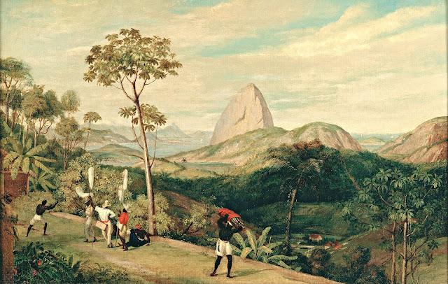
PAO DE AÇUCAR PAINTED BY CHARLES LANDEER


CHARLES LANDEER (1799-1879) Pao de Açucar / Sugarloaf Mountain / (396 m - 1299 ft) Brazil  In  "View of Sugarloaf Mountain from the Silvestre Road 1827, oil on canvas,  61,5x91 cm, Pinacoteca do Estado de São Paulo, Brazil

CHARLES LANDEER (1799-1879)
Pao de Açucar / Sugarloaf Mountain / (396 m - 1299 ft)
Brazil

In View of Sugarloaf Mountain from the Silvestre Road 1827, oil on canvas, 61,5 x 91 cm,
Pinacoteca do Estado de São Paulo, Brazil


The painter
Charles Landseer (RA) was an English painter, mostly of historical subjects. He was born the second son of the engraver John Landseer, and the elder brother of the animal painter, Sir Edwin Landseer. He trained under his father, and the painter Benjamin Robert Haydon. He was awarded the silver palette of the Royal Society of Arts for a drawing of Laocoon in 1815, and in 1816 he entered the Royal Academy Schools where he was taught by Henry Fuseli. In 1823 he accompanied Sir Charles Stuart de Rothesay on a diplomatic mission to Portugal and Brazil. Many of the drawings he made on the journey were shown at the British Institution in 1828. He became an associate in of the Royal Academy in 1837, and a full academician in 1845. In 1851, he was appointed Keeper of the Royal Academy, a post requiring him to teach in the "Antique School". He remained in the position until 1873.  Most of his pictures were of subjects from British history, or from literature. He paid close attention to the historical accuracy of the accessories and details in his paintings. His works included The Meeting of Charles I. and his Adherents before the Battle of Edgehill, Clarissa Harlowe in the Prison Room of the Sheriff's Office (1833, now in the collection of the Tate Gallery), The Pillaging of a Jew's House in the Reign of Richard I (1839, Tate Gallery) and The Temptation of Andrew Marvel (1841). While under Haydon's instruction he also made a series of detailed anatomical drawings.  He died in London on 22 July 1879, leaving  quite generously 10,000 guineas to the Royal Academy to fund scholarships.

The mountain
Sugarloaf Mountain (396 m - 1299 ft), Pao de Açucar in Portuguese, Pain de Sucre in French, is a isolated peak (Inselberg) situated in Rio de Janeiro, Brazil, at the mouth of Guanabara Bay on a peninsula that sticks out into the Atlantic Ocean. Rising above the harbor, its name is said to refer to its resemblance to the traditional shape of concentrated refined loaf sugar. It is known worldwide for its cableway and panoramic views of the city. The name "Sugarloaf" was coined in the 16th century by the Portuguese during the heyday of sugar cane trade in Brazil. According to historian Vieira Fazenda, blocks of sugar were placed in conical molds made of clay to be transported on ships. The shape given by these molds was similar to the peak, hence the name.
Climbing routes:
1907 – The Brazilian engineer Augusto Ferreira Ramos had the idea of linking the hills through a path in the air.
1910 – The same engineer founded the Society of Sugar Loaf and the same year the works were started. The project was commissioned in Germany and built by Brazilian workers. All parts were taken by climbing mountains or lift by steel cables.
1912 – Opening of the tram. First lift of Brazil. The first cable cars were made of coated wood and were used for 60 years.
1972 – The current template trolley was put into operation. This increased the carrying capacity by almost ten times.
2009 – Inauguration of the next generation of cable cars that had already been purchased and are on display at the base of Red Beach.
Visitors can watch rock climbers on Sugarloaf and the other two mountains in the area: Morro da Babilônia (Babylon Mountain), and Morro da Urca (Urca's Mountain). Together, they form one of the largest urban climbing areas in the world, with more than 270 routes, between 1 and 10 pitches long.

Wednesday, July 20, 2022

THE GREAT SUGAR LOAF PAINTED BY GEORGE BARRET Sr.

GEORGE BARRET Sr. (1730-1784) The Great Sugar Loaf (501 m-1,644 ft) Ireland  In Powerscourt House, Co. Wicklow with the Great Sugarloaf mountain, 1760, oil on canvas,  73,3 x 97,1 cm, Yale Center for British Art, Paul Mellon collection

GEORGE BARRET Sr. (1730-1784)
The Great Sugar Loaf (501 m-1,644 ft)
Ireland

In Powerscourt House, Co. Wicklow with the Great Sugarloaf mountain, 1760, oil on canvas, 
73,3 x 97,1 cm, Yale Center for British Art, Paul Mellon collection

The mountain
The Great Sugar Loaf  (501 m-1,644 ft),  not to be confused with Sugar Loaf  in Brazil or with Sugar Loaf Mountain in USA neither with  the Pain de Sucre in France...  is the 404th–highest peak in Ireland on the Arderinscale, however, being below 600 m it does not rank on the Vandeleur-Lynam or Hewitt scales].  The mountain is in the far northeastern section of the Wicklow Mountains, in Ireland, and overlooks the village of Kilmacanogue. The profile of the mountain means it can be mistaken for a dormant volcano. It owes its distinctive shape, however, to the erosion-resistant metamorphosed deep-sea sedimentary deposit from which its quartzite composition was derived.
According to Irish academic Paul Tempan, the term "sugarloaf" is widely applied in Britain and Ireland to hills of conical form, in much the same way that the name pain de sucre is used in France. Tempan also notes that there is a widespread misconception that the term refers to a kind of bread, when it refers in fact to the stalagmite-like form in which sugar was sold up until the 19th-century, prior to the advent of granulated sugar. The traditional method for making a sugarloaf was complex, involving repeated purifications, moulding and a leaching process gradually to refine the mass of sugar, by ridding it of its associated molasses and eventually all trace of colour, leaving it a glistening white. This form of sugar is still used in the German alcoholic drink, Feuerzangenbowle. Tempan notes that a 1935 article by Eoin MacNeill in the Journal of the Royal Society of Antiquaries of Ireland (JRSAI), on placenames mentioned in the Togail Bruidne Dá Derga, suggested that Irish: Ó Cualann could refer to "sheep of Cualu", but considered it unlikely.


The Painter
George Barret Sr. RA was an Irish landscape artist best known for his oil paintings, but also sometimes produced watercolours. He left Ireland in 1762 to move to London where he soon gained recognition as a leading artist of the period. He exhibited at the Society of Artists of Great Britain and was able to gain patronage from many leading art collectors. Barrett with other leading members left the Society in 1768 to found the Royal Academy, where he continued to exhibit until 1782. Barrett appears to have travelled extensively in England including the Lake District and the Isle of Wight, Wales, and Scotland to undertake commissions for his patrons. He suffered from asthma and this caused him to move in 1772 to Westbourne Green, at the time a country village to the west of Paddington. While he earned considerable quantities of money from his paintings, he has been described as being ‘'feckless'’ with money. He was helped in 1782 by Edmund Burke, with whom he had become friends when Burke attended Trinity College, Dublin. On Burke's recommendation he obtained the appointment of master painter of Chelsea Hospital, a post he held until his death in 1784. At the time of his death his widow and children were left destitute, but the Royal Academy granted her a pension of thirty pounds a year.
_______________________________

2022 - Wandering Vertexes...
by Francis Rousseau


Sunday, July 17, 2022

MOUNT SINAÏ / JABAL MUSA PAINTED BY EDWARD LEAR

EDWARD LEAR(1812-1888) Mount Sinaï / Jabal Musa (2,285 m - 7,496ft) Egypt   In View of Mount Sinai, Watercolor,with some white tempera, over pencil, on cream-colored wove paper. (178 x 376 mm) Purchased as the gift of Mrs. Vincent Astor,  The Morgan Library & Museum

EDWARD LEAR (1812-1888)
Mount Sinaï / Jabal Musa (2,285 m - 7,496ft)
Egypt

In View of Mount Sinai, Watercolor,with some white tempera, over pencil, on cream-colored wove paper.
(178 x 376 mm) Purchased as the gift of Mrs. Vincent Astor,  The Morgan Library & Museum

The mountain
Mount Sinaï (2,285 m - 7,496ft) or Jabal Mūsā or Gabal Mūsā (in arab : "Moses' Mountain" or "Mount Moses"), also known as Mount Horeb or Jebel Musa (a similarly named mountain in Morocco), is a mountain in the Sinai Peninsula of Egypt that is a possible location of the biblical Mount Sinaï.
The latter is mentioned many times in the Book of Exodus (and other books of the Bible) and in the Quran. According to Jewish, Christian, and Islamic tradition, the biblical Mount Sinai was the place where Moses received the Ten Commandments (depicted in the Jean-Léon Gérôme painting above).
Mount Sinai is a moderately high mountain near the city of Saint Katherine in the Sinai region. It is next to Mount Katherine (2,629m - 8,625 ft), the highest peak in Egypt.
Mount Sinai's rocks were formed in the late stage of the Arabian-Nubian Shield's (ANS) evolution. Mount Sinai displays a ring complex that consists of alkaline granites intruded into diverse rock types, including volcanics. The granites range in composition from syenogranite to alkali feldspar granite. The volcanic rocks are alkaline to peralkaline and they are represented by subaerial flows and eruptions and subvolcanic porphyry. Generally, the nature of the exposed rocks in Mount Sinai indicates that they originated from differing depths.
There are two principal routes to the summit. The longer and shallower route, Siket El Bashait, takes about 2.5 hours on foot, though camels can be used. The steeper, more direct route (Siket Sayidna Musa) is up the 3,750 "steps of penitence" in the ravine behind the monastery.
The summit of the mountain has a mosque that is still used by Muslims. It also has a Greek Orthodox chapel, constructed in 1934 on the ruins of a 16th-century church, that is not open to the public. The chapel encloses the rock which is considered to be the source for the biblical Tablets of Stone. At the summit also is "Moses' cave", where Moses was said to have waited to receive the Ten Commandments

The painter
Edward Lear was an English artist, illustrator, musician, author and poet, and is known now mostly for his literary nonsense in poetry and prose and especially his limericks, a form he popularised. His principal areas of work as an artist were threefold: as a draughtsman employed to illustrate birds and animals; making coloured drawings during his journeys, which he reworked later, sometimes as plates for his travel books; as a (minor) illustrator of Alfred Tennyson's poems. As an author, he is known principally for his popular nonsense collections of poems, songs, short stories, botanical drawings, recipes, and alphabets. He also composed and published twelve musical settings of Tennyson's poetry.
Lear was already drawing "for bread and cheese" by the time he was aged 16.
In 1842, Lear began a journey into the Italian peninsula, travelling through the Lazio, Rome, Abruzzo, Molise, Apulia, Calabria, and Sicily. In personal notes, together with drawings, Lear gathered his impressions on the Italian way of life, folk traditions, and the beauty of the ancient monuments. Of particular interest in Lear was the Abruzzo, which he visited in 1843, through the Marsica (Celano, Avezzano, Alba Fucens, Trasacco) and the plateau of Cinque Miglia (Castel di Sangro and Alfedena), by an old sheep track of the shepherds.
Among his travels, he visited Greece and Egypt during 1848-49, and toured India and Ceylon during 1873–75. While travelling he produced large quantities of coloured wash drawings in a distinctive style, which he converted later in his studio into oil and watercolour paintings, as well as prints for his books. His landscape style often shows views with strong sunlight, with intense contrasts of colour. Between 1878 and 1883 Lear spent his summers on Monte Generoso, a mountain on the border between the Swiss canton of Ticino and the Italian region of Lombardy. His watercolor Mount Olympus dated 1849 in in the MET in New York City. His oil painting The Plains of Lombardy from Monte Generoso is in the Ashmolean Museum Oxford (UK).

_______________________________

2022 - Wandering Vertexes...
by Francis Rousseau 

Thursday, July 14, 2022

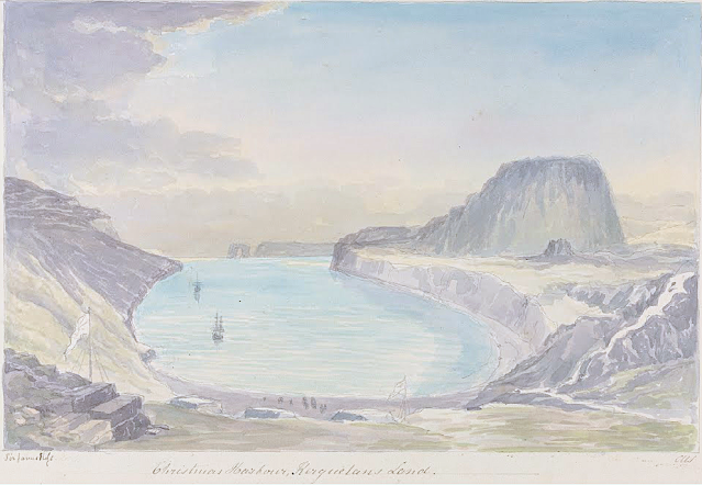
LA TABLE DE L'OISEAU SKETCHED BY CHARLES HAMILTON SMITH

CHARLES HAMILTON SMITH (1776-1859) La Table de l'Oiseau (403m - 1,322 ft) Antarctica - France   In Christmas Harbour,  Kerguelen's Land, watercolor,

CHARLES HAMILTON SMITH (1776-1859)
La Table de l'Oiseau (403m - 1,322 ft)
Antarctica - France

 In Christmas Harbour,  Kerguelen's Land, watercolor


The hill
The Table de l'Oiseau (403m - 1,322 ft) (Table ot the Bird) is a hill overlooking Port-Christmas by the north. Port-Christmas is one of the most isolated and difficult to reach points in the archipelagok.  Given the distance and especially the rugged topography, the site is almost never reached by land. However, it can be reached by sea after sailing for at least 100 nautical miles (190 km). The baie de l'Oiseau, at the bottom of which it is located, forms the first indentation at the northeast end of the Loranchet peninsula. The bay is closed to the north by Cap Français, to the south by Pointe de l'Arche (seen in the foreground).
While the shores of the bay are mostly rocky and often steep, the bottom is occupied by a strike, about 350 meters long, of black sand resulting from the erosion of the surrounding basaltic rocks. pours into the sea, after having collected runoff water from Mount Havergal on the one hand, and that from the outlet of Rochegude Lake on the other. This lake, located about 500 m from the shore and 40 m above sea level, marks the shoulder that separates Port-Christmas from Ducheyron Bay, to the west.
The anchorage at Port-Christmas allows you to anchor at a depth of 11 meters. It offers relatively safe shelter to sailors who frequent this particularly turbulent ocean sector of the Roaring Forties.

The artist
Lieutenant-Colonel Charles Hamilton Smith, was an English artist, naturalist, antiquary, illustrator, soldier, and... spy as well !. His military career began in 1787, when he studied at the Austrian academy for artillery and engineers at Mechelen and Leuven in Belgium (his native country). Although his military service, which ended in 1820 and included the Napoleonic Wars, saw him travel extensively (including the West Indies, Canada, United States, Southern and Northern Europe and ...Antarctica).
As a prolific self-taught illustrator (over 38,000 drawings!) He left quite an important number of books of beautifully watercolored landscapes taken all around the world. those nooks of watercolors are nowadays in the collections of the Yale Center From British Art. Among them :
- Views of France, Volume I (81 watercolors), Views of France, Volume II (93 watercolors),
- Views of England and Wales, Volume I (82 watercolors), Views of England and Wales, Volume II (74 watercolors),
- Views of Northern Europe, Volume I (68 watercolors), Views of Northern Europe, Volume II (78) watercolors),
- Views of Polar Regions (75 watercolors) (see above)
- Views of Spain, Volume I (69 watercolors), Views of Spain, Volume II (72 watercolors), But one of his noteworthy achievements was an 1800 experiment to determine which color should be used for military uniforms. He is also known in military history circles for Costume of the Army of the British Empire, produced towards the end of the Napoleonic Wars and an accurate depiction of contemporary British uniform.
As an antiquarian, he also produced, in collaboration with Samuel Rush Meyrick, Costume of the Original Inhabitants of the British Islands, 1815, and The Ancient Costume of England, with historical illustrations of medieval knights, ladies, shipsm and battles.
He also wrote on the history of the Seven Years' War and The Natural history of dogs.
Quite a productive fellow !
___________________________________________

2022 - Wandering Vertexes...
by Francis Rousseau

Monday, July 11, 2022

DJEBEL TOUKBAL (4) PAINTED BY SIR WINSTON CHURCHILL


SIR WINSTON CHURCHILL (1874-1965) Jebel Toubkal (4,167 m - 13, 671 ft) Morocco  In Atlas mountains viewed from Marrakech, oil on canvas, 1949.

SIR WINSTON CHURCHILL (1874-1965)
Jebel Toubkal (4,167 m - 13, 671 ft)
Morocco

In Atlas mountains viewed from Marrakech, oil on canvas, 1949.


The mountain 

Jebel Toubkal (4,167 m - 13, 671 ft)  is the high point of the High Atlas as well as Morocco and North Africa . It is located 63 km south of Marrakech, in the province of Al Haouz, inside the national park that bears its name.
The word Toubkal would be a deformation of French origin of the same Amazigh name Tugg Akal or toug-akal  which means "the one who looks up the earth". The people of this region still use this name.  The Toubkal massif is made up of rocks of various natures. Dark rocks of volcanic origin are found on the summits of andesite and rhyolite. Glaciers have left characteristic marks of their passage in the form of valleys in trough. During the Würm glaciation, the present valley of Assif n'Ait Mizane  was occupied by the longest glacier in the Atlas, about 5 km long.
The climate at Jebel Toubkal  is mountainous. The snow falls in winter and covers the summit.
In the nineteenth century, the interior of Morocco was still terra incognita for the Europeans and for a long time the Jebel Ayachi (3,747 m -12,293ft) ) passed for the highest summit of the High Atlas. In fact, the Toubkal was officially climbed for the first time only on 12 June 1923 by the Marquis de Segonzac, accompanied by Vincent Berger and Hubert Dolbeau. The cairns which they found on the summit had been built by the Berbers of the environs for whom the Toubkal is a holy place dedicated to Sidi Chamarouch (or Chamharouch). A sanctuary is dedicated to him on the way from Imlil to Toubkal.
The ascent of the roof of North Africa attracts a large number of followers of the trekking. This ascent attracts the crowd as much as it does not present great technical difficulties and that the assistance of the muleteers and their mules reduces the physical efforts. The altitude is relatively high (3,200 meters at the shelter and 4,167 meters at the summit).

The artist
Winston Leonard Spencer-Churchill was forty before he discovered the pleasures of painting. The compositional challenge of depicting a landscape gave the heroic rebel in him temporary repose. He possessed the heightened perception of the genuine artist to whom no scene is commonplace. Over a period of forty-eight years his creativity yielded more than 500 pictures. His art quickly became half passion, half philosophy. He enjoyed holding forth in speech and print on the aesthetic rewards for amateur devotees. To him it was the greatest of hobbies. He had found his other world -- a respite from crowding events and pulsating politics.
Encouragement to persevere with his hobby stemmed from an amateur prize (his first) which he won for "Winter Sunshine, Chartwell" a bright reflection of his Kentish home. He sent five paintings to be exhibited in Paris in the 1920s.
Modesty shone through that self-estimate. Modesty - and warm sympathy --were undeniably evident in what Churchill told a fellow painter, Sergeant Edmund Murray, his bodyguard from 1950 to 1965. Murray had been in the Foreign Legion and the London Metropolitan Police. Interviewing him to gauge his suitability, Churchill said: "You have had a most interesting life. And I hear you even paint in oils." After Murray had his work rejected by the Royal Academy, Churchill told him: "You know, your paintings are so much better than mine, but yours are judged on their merit."
Churchill's progressive workmanship demonstrates that a pseudonym employed at a crucial stage shrewdly enabled him to find out where he stood before moving on to fine-tool his talent.Churchill again favoured a pseudonym (Mr. Winter) in 1947 when offering works to the Royal Academy, so his fame in other spheres was not exploited. Two pictures were accepted and eventually the title of Honorary Academician Extraordinary was conferred on him. He earned it. That is borne out by the conclusion of the renowned painter Sir Oswald Birley: "If Churchill had given the time to art that he has given to politics, he would have been by all odds the world's greatest painter." Connoisseurs of Sir Winston's art stoutly defend their individual preference, but there are convincing arguments for bestowing highest praise on "The Blue Sitting Room, Trent Park" which was sold in 1949 to aid charity.
Despite outward flippancy, Churchill had a true craftsman's dedication when he took up a paint brush. He consulted teachers admired for their professionalism. He was fond of citing Ruskin's Elements of Drawing and readily accepted Sir William Orpen's suggestion that he should visit Avignon, where the light can verge on a miracle. He recalled an encounter on the Côte d'Azur with artists who worshipped at the throne of Cezanne and gratefully acknowledged the inspiration he derived from their exchange. Marrakech, Morocco -- irresistible and productive -- always brought out the best in him.
Churchill sought and found tranquillity in his art. His much quoted words, summing up expectations of celestial bliss, retain their lustre: "When I get to heaven I mean to spend a considerable portion of my first million years in painting, and so get to the bottom of the subject..."
___________________________________________


2022 - Wandering Vertexes...
by Francis Rousseau
 

Friday, July 8, 2022

EL VULCAN PLANCHÒN-PETEROA PHOTOGRAPHED BY LEO WEHRLI


LEO WEHRLI (1870–1954) El Planchón-Peteroa (4,107 m - 13,474 ft) Argentina- Chile border  In Planchon Vulcan photo1897, hand colorized by Anna Wehrli-Frey 1918, ETH Library, Zurich

LEO WEHRLI (1870–1954)
El Planchón-Peteroa (4,107 m - 13,474 ft)
Argentina- Chile border

In Planchon Vulcan, photo,1897, hand colorized by Anna Wehrli-Frey 1918,
ETH Library, Zurich


The volcano
EL Planchón-Peteroa (4,107m - 13,474 ft) also known as Azufre-Planchón-Peteroa or Nevado de los Banos is a complex of active volcanoes extending in a north–south direction along the border between Argentina and Chile. It consists of volcanoes of various ages with several overlapping calderas. Those include Volcán Planchón, Volcán Peteroa and Volcán Azufre. A partial collapse of the complex about 11,500 years ago produced a major debris avalanche, which followed the course of the Teno River until reaching the Chile Central Valley. Peteroa has a crater lake. Lagunas de Teno lies at the foot of Planchón volcano. In this area also is the Vergara International Pass.
Planchón-Peteroa Volcano erupted on September 6, followed by a stronger eruption on September 18. On September 6, 2010, , the volcano erupted once again, emitting a dark gray plume of volcanic ash. As winds blew the ash southeast into Argentina, residents there were warned by authorities to evacuate the nearby areas before Planchón-Peteroa would erupt again.

The photographer
Leo Wehrli was a Swiss geologist, professor and explorer. After studying music, botany, chemistry, mineralogy, petrography and geology in Berlin and Zurich, Wehrli became assistant to Albert Heim. Immediately after completing his thesis, he left for Argentina with the famous Carl Emanuel Burckhardt in 1896. Accredited by the La Plata Museum and the government of Argentina, he explored the Andes he crossed at least five times during a stay of two years. His work was more particularly oriented on the delimitation of the border between Argentina and Chile after the agreement signedbetween these two countries in 1881 and on the determination of the property of mountain peaks, ridge lines and basins slopes.
After his return to Switzerland, he worked between 1900 and 1935 as a teacher and then lecturer for the Geol. Centralblatt in Berlin ; between 1901 and 1912, he wrote nearly 500 articles. He made other trips through Europe and North Africa (Egypt) before going back to Argentina again in 1938. He has summarized his research results in numerous articles, notably in the Geographic Lexicon of Switzerland. He participated in the founding of the Zurich Adult Education Center and gave lectures there from 1921 to 1953. From 1931 to 1951 he was a member of the Swiss Alpine Club SAC commission for the Central Library and has was president for 14 years.
Wehrli left a collection of 15,000 slides, some of which were hand-colored by his wife, born Anna Frey. A large part of the works is made available online by the photographic archives of the ETH-Bibliothek in Zurich.

___________________________________________

2022 - Wandering Vertexes...
by Francis Rousseau

Tuesday, July 5, 2022

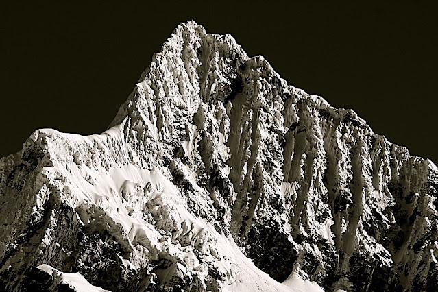
ALPAMAYO SUMMIT PHOTOGRAPHED IN 1936 BY ERWIN SCHNEIDER


ERWIN SCHNEIDER (1906-1987) Alpamayo ( 5,947m - 19,511 ft) Peru  In  "Alpamayo summit", argentic photo 1936 
 
 
ERWIN SCHNEIDER (1906-1987) 
Alpamayo ( 5,947m - 19,511 ft) 
Peru

In  "Alpamayo summit", argentic photo 1936


The mountain

Alpamayo ( 5,947m - 19,511 ft) possibly named from Quechua words is one of the most conspicuous peaks in the Cordillera Blanca of the Peruvian Andes. Alpamayo Creek originates northwest of it. The Alpamayo lies next to the slightly higher Quitaraju. n July 1966, the German magazine "Alpinismus", published a photo of Alpamayo taken by American photographer Leigh Ortenburger accompanied by an article on a survey among mountaineering experts, who chose Alpamayo as "The Most Beautiful Mountain in the World". Not defined by a single summit Alpamayo has two sharp summits, the North and south, which are separated by a narrow corniced ridge.
The first attempt on Alpamayo's summit was in 1948 by a Swiss expedition. Climbing by way of the heavily corniced North Ridge, the three climbers came within sight of the virgin summit when a large cornice broke under them and they were carried down the precipitous Northwest Face. By some amazing piece of good fortune, the three were neither buried nor injured by the 650 foot fall and they were able to make an 'orderly retreat' from the mountain. In 1951, a Franco-Belgian expedition including George and Claude Kogan claimed to have made the first ascent via the North Ridge. After studying the photos in George Kogan's book The Ascent of Alpamayo, the German team of Günter Hauser, Frieder Knauss, Bernhard Huhn and Horst Wiedmann came to the conclusion that the 1951 team did not reach the actual summit, thereby making their ascent via the South Ridge in 1957 the first. Although the South Ridge is no less steep or dangerous than the North Ridge, it has the advantage of leading directly to the higher south summit. This was written up in Hauser's book White Mountain and Tawny Plain. Although there are several climbing routes on the Southwest Face the most common is known as the Ferrari or Italian Route. It was opened in 1975 by a group of Italian alpinists led by Casimiro Ferrari. It begins at the top of the highest point of the snow slope where the bergshrund separates the upper face on the left and then ascends a steep runnel to the summit ridge. Because of its esthetic beauty, Alpamayo is one of the most climbed mountains in the Andes and the base camp can be a hodge-podge of nationalities. Each year the route is made easy by the first party to ascend the route as they usually leave snow-stakes in place at the belay stations. Then it is just a matter of finding out what length of rope they used so that your rope is long enough to reach each station. In the summer of 1988, they had used 50m ropes.

The photographer
Erwin Hermann Manfred Schneider was an Austrian mountaineer. On July 25, 1928, he was part of the German-Soviet expedition for the first ascent of Lenin Peak. They reach the top with Karl Wien and Eugen Allwein. In 1930, he participated in an expedition in the Himalayas led by Günter Dyhrenfurth to Kangchenjunga. On June 21, 1931, he made the first ascent of Jongsong Peak at 7,462 meters1,2. They climb the Ramthang Chang at 6,802 meters. In 1932 and 1936, he took part in two expeditions organized by the German-Austrian Alpine Club (DuOeAV). During these expeditions, Schneider and his companions made about ten first ascents.

___________________________________________
2022 - Wandering Vertexes...
by Francis Rousseau

Saturday, July 2, 2022

VERY LARGE ICEBERG PAINTED BY ROCKWELL KENT

ROCKWELL KENT (1882-1971), Very Large Iceberg (180m-590ft) Greenland / Danemark  In "Grayday, Green land Iceberg", oil on canvas.


ROCKWELL KENT (1882-1971)
Very Large Iceberg (180m-590ft) Greenland / Danemark
In "Grayday, Green land Iceberg", oil on canvas.


The painter
Rockwell Kent, artist, author, and political activist, had a long and varied career. During his lifetime, he worked as an architectural draftsman, illustrator, printmaker, painter, lobsterman, ship's carpenter, and dairy farmer. Born in Tarrytown Heights, New York, he lived in Maine, Newfoundland, Alaska, Greenland, and the Adirondacks and explored the waters around Tierra del Fuego in a small boat. Kent's paintings, lithographs, and woodcuts often portrayed the bleak and rugged aspects of nature; a reflection of his life in harsh climates.His experience as a carpenter and builder and his familiarity with tools served him well when he took up the graphic process. His blocks were marvels of beautiful cutting, every line deliberate and under perfect control. The tones and lines in his lithography were solidly built up, subtle, and full of color. He usually made preliminary studies- old-mater style- for composition or detail before starting on a print. Nothing was vague or accidental about his work; his expression was clear and deliberate. Neither misty tonalities nor suggestiveness were to his taste. He was a highly objectified art - clean, athletic, sometimes almost austere and cold. He either recorded adventures concretely, or dealt in ideas. His studio was a model of the efficient workshop: neat, orderly, with everything in its place. His handwriting, the fruit of his architectural training, was beautiful and precise.
Among the many notes of increasing awareness of Kent's contributions to American culture is the reproduction of one of Kent's pen-and-ink drawings from Moby Dick on a U.S. postage stamp, part of the 2001 commemorative panel celebrating such American illustrators as Maxfield Parrish, Frederic Remington, and Norman Rockwell.

The Iceberg
An iceberg is a piece of freshwater ice more than 15 m long that has broken off a glacier or an ice shelf and is floating freely in open (salt) water.  Smaller chunks of floating glacially-derived ice are called "growlers" or "bergy bits".  Both are generally spawned from disintegrating icebergs.[ Iceberg size classes, as established by the International Ice Patrol, are summarized in Table 1. The 1912 loss of the RMS Titanic led to the formation of the International Ice Patrol in 1914. Much of an iceberg is below the surface, which led to the expression "tip of the iceberg" to illustrate a small part of a larger unseen issue. Icebergs are considered a serious maritime hazard.  Icebergs vary considerably in size and shape. Icebergs that calve from glaciers in Greenland, are often irregularly shaped while Antarctic ice shelves often produce large tabular (table top) icebergs. The largest iceberg currently floating in the ocean, named A-76, calved from the Ronne Ice Shelf into the Weddell Sea in Antarctica measuring 4320 km2.  The largest iceberg in recent history, named B-15, measured nearly 300 km x 40 km. The B-15 iceberg calved from the Ross Ice Shelf in January 2000.  The largest iceberg on record was an Antarctic tabular iceberg of over 31,000 square kilometres (12,000 sq mi) [335 by 97 kilometres (208 by 60 mi)] sighted 240 kilometres (150 mi) west of Scott Island, in the South Pacific Ocean, by the USS Glacier on November 12, 1956. This iceberg was larger than Belgium. Big icebergs are also often compared in size to the area of Manhattan The largest icebergs recorded have been calved, or broken off, from the Ross Ice Shelf of Antarctica. Icebergs may reach a height of more than 100 metres (300 ft) above the sea surface, and have mass ranging from about 100,000 tonnes up to more than 10 million tonnes. Icebergs or pieces of floating ice smaller than 5 meters above the sea surface are classified as "bergy bits"; smaller than 1 meter—"growlers". The largest known iceberg in the North Atlantic was 168 metres (551 ft) above sea level, reported by the USCG icebreaker Eastwind in 1958, making it the height of a 55-story building. These icebergs originate from the glaciers of western Greenland and may have interior temperatures of −15 to −20 °C (5 to −4 °F).


___________________________________________
2022 - Wandering Vertexes...
by Francis Rousseau

Thursday, June 30, 2022

PICO DEL TEIDE SKETCHED BY ALEXANDER VON HUMBOLDT


ALEXANDER VON HUMBOLDT (1769-1859), Pico del Teide (3, 718 m -12, 198 ft) Tenerife - Canari Islands - Spain   In  "Intérieur du Cratère du Pic de Teneriffe " Dessin, Alexander von Humboldt


ALEXANDER VON HUMBOLDT (1769-1859)
Pico del Teide (3, 718 m -12, 198 ft)
Tenerife - Canari Islands - Spain

 In  "Intérieur du Cratère du Pic de Teneriffe " Dessin, Alexander von Humboldt


The mountain
Pico del Teide (3,718m - 12,198 ft) (« Teide Peak") is a volcano on Tenerife in the Canary Islands, Spain. Before the 1495 Spanish colonization of Tenerife, the native Guanches called the volcano Echeyde, which in their legends referred to a powerful figure leaving the volcano, which could turn into hell. El Pico del Teide is the modern Spanish name.
Its summit is the highest point in Spain and the highest point above sea level in the islands of the Atlantic. If measured from its base on the ocean floor, it is at 7,500 m-24,600 ft the third highest volcano on a volcanic ocean island in the world after Mauna Kea and Mauna Loa in Hawaii. Its elevation makes Tenerife the tenth highest island in the world. It remains active: its most recent eruption occurred in 1909 from the El Chinyero vent on the northwestern Santiago rift.
Historical volcanic activity on the island is associated with vents on the Santiago or northwest rift (Boca Cangrejo in 1492, Montañas Negras in 1706, Narices del Teide or Chahorra in 1798 and El Chinyero in 1909) and the Cordillera Dorsal or northeast rift (Fasnia in 1704, Siete Fuentes and Arafo in 1705). The 1706 Montañas Negras eruption destroyed the town and principal port of Garachico, as well as several smaller villages.
In 1492, Christopher Columbus reported seeing "a great fire in the Orotava Valley" as he sailed past Tenerife on his voyage to discover the New World. This was interpreted as indicating that he had witnessed an eruption there. Radiometric dating of possible lavas indicates that in 1492 no eruption occurred in the Orotava Valley, but one did occur from the Boca Cangrejo vent.
The last summit eruption from Teide occurred about the year 850 CE, and this eruption produced the "Lavas Negras" that cover much of the flanks of the volcano.
About 150,000 years ago, a much larger explosive eruption occurred, probably of Volcanic Explosivity Index 5.
The United Nations Committee for Disaster Mitigation designated Teide a Decade Volcano because of its history of destructive eruptions and its proximity to several large towns, of which the closest are Garachico, Icod de los Vinos and Puerto de la Cruz. Teide, Pico Viejo and Montaсa Blanca form the Central Volcanic Complex of Tenerife.
In a publication of 1626, Sir Edmund Scory, who probably stayed on the island in the first decades of the 17th century, gives a description of Teide, in which he notes the suitable paths to the top and the effects the considerable height causes to the travellers, indicating that the volcano had been accessed via different routes before the 17th century. In 1715 the English traveler J. Edens and his party made the ascent and reported their observations in the journal of the Royal Society in London.
After the Enlightenment, most of the expeditions that went to East Africa and the Pacific had Teide as one of the most rewarding targets. The expedition of Lord George Macartney, George Staunton and John Barrow in 1792 almost ended in tragedy, as a major snowstorm and rain swept over them and they failed to reach the peak of Teide, just barely getting past Montaña Blanca.
During an expedition to Kilimanjaro, the German adventurer Hans Heinrich Joseph Meyer visited Teide in 1894 to observe ice conditions on the volcano. He described the two mountains as "two kings, one rising in the ocean and the other in the desert and steppes"
The volcano and its surroundings comprise Teide National Park, which has an area of 18,900 hectares (47,000 acres) and was named a World Heritage Site by UNESCO on June 28, 2007. Teide is the most visited natural wonder of Spain, the most visited national park in Spain and Europe and – by 2015 – the eighth most visited in the world, with some 3 million visitors yearly. A major international astronomical observatory is located on the slopes of the mountain.

The cartographer
Friedrich Wilhelm Heinrich Alexander von Humboldt was a Prussian geographer, naturalist, explorer, and influential proponent of Romantic philosophy and science. He was the younger brother of the Prussian minister, philosopher, and linguist Wilhelm von Humboldt (1767–1835). Humboldt's quantitative work on botanical geography laid the foundation for the field of biogeography. Humboldt's advocacy of long-term systematic geophysical measurement laid the foundation for modern geomagnetic and meteorological monitoring.
Between 1799 and 1804, Humboldt travelled extensively in Latin America, exploring and describing it for the first time from a modern scientific point of view. His description of the journey was written up and published in an enormous set of volumes over 21 years. Humboldt was one of the first people to propose that the lands bordering the Atlantic Ocean were once joined (South America and Africa in particular). Humboldt resurrected the use of the word cosmos from the ancient Greek and assigned it to his multi-volume treatise, Kosmos, in which he sought to unify diverse branches of scientific knowledge and culture. This important work also motivated a holistic perception of the universe as one interacting entity.
On their way back to Europe from Mexico on their way to the United States, Humboldt and his fellow scientist Aimé Bonpland stopped in Cuba for a While. After their first stay in Cuba of three months they returned the mainland at Cartagena de Indias (now in Colombia), a major center of trade in northern South America. Ascending the swollen stream of the Magdalena River to Honda and arrived in Bogotá on July 6, 1801 where they met Spanish botanist José Celestino Mutis, the head of the Royal Botanical Expedition to New Granada, staying there until September 8, 1801. Mutis was generous with his time and gave Humboldt access to the huge pictorial record he had compiled since 1783. Humboldt had hopes of connecting with the French sailing expedition of Baudin, now finally underway, so Bonpland and Humboldt hurried to Ecuador. They crossed the frozen ridges of the Cordillera Real, they reached Quito on 6 January 1802, after a tedious and difficult journey.
Their stay in Ecuador was marked by the ascent of Pichincha and their climb of Chimborazo, where Humboldt and his party reached an altitude of 19,286 feet (5,878 m). This was a world record at the time, but a thousand feet short of the summit. Humboldt's journey concluded with an expedition to the sources of the Amazon en route for Lima, Peru.
At Callao, the main port for Peru, Humboldt observed the transit of Mercury. On 9 November and studied the fertilizing properties of guano, rich in nitrogen, the subsequent introduction of which into Europe was due mainly to his writings.

___________________________________________
2022 - Wandering Vertexes...
by Francis Rousseau

Monday, June 27, 2022

PICO TURQUINO (3) PAINTED BY EDMUND DARCH LEWIS


EDMUND DARCH LEWIS (1835-1910)  Pico Turquino  (1,974m- 6,476 ft)  Cuba   In Pico Turquino - View of Cuba, oil on canvas, 1850.

EDMUND DARCH LEWIS (1835-1910) 
Pico Turquino  (1,974m- 6,476 ft) 
Cuba 

In Pico Turquino - View of Cuba, oil on canvas, 1850.

The mountain
Pico Turquino (literally "Turquoise Peak") is Cuba's highest point at 1,974 meters above sea level. Located in the center of the Sierra Maestra, it lies within the Turquino National Park - also known as the Sierra Maestra National Park. Its summit has been the subject of a sort of pilgrimage since the father of the revolutionary fighter Celia Sánchez erected in 1953 a bust of the national hero José Martí.

The artist
Edmund Darch Lewis was an American landscape painter known for his prolific style, marine oils and watercolors. Lewis was born in Philadelphia, Pennsylvania, in a well-to-do family. He started training at age 15 with German-born Paul Weber (1823–1916) of the Hudson River School.
At age 19 he exhibited at the Pennsylvania Academy of the Fine Arts, and was elected an Associate of the Academy at age 24.
Lewis's early work in oil, because of his excellent training, was precocious and is considered technically superior to his later work. He traveled throughout Pennsylvania, New Jersey and New York, painting river scenes, and for two decades he traveled to the White Mountains and painted landscapes of mountains, rivers, and lakes. He made extensive marine paintings throughout New England, becoming a prolific and successful artist. His work was appreciated because of the luminosity of their objects. Because of the lively yet glowing work, he is considered one of the Luminist painters in the Hudson River School.
After mastering oil painting early in his career, Lewis switched to watercolor painting. Although not as technically outstanding, his watercolors were also admired for their luminosity - Luminism, and Lewis continued to generate canvases in mass production style.
___________________________________________
2022 - Wandering Vertexes...
by Francis Rousseau

Friday, June 24, 2022

MUQUR PHOTOGRAPHED BY FRÉDÉRIC GADMER


FRÉDÉRIC GADMER (1878-1954) Muqur (2,003 m -6,572 ft) Afghanistan  In La chaine du Moqor, autochrome  Lumière on glass tint  1928, Mission Clémenceau, Musée Albert Kahn, Paris


FRÉDÉRIC GADMER (1878-1954)
Muqur (2,003 m -6,572 ft)
Afghanistan

In La chaine du Moqor, autochrome Lumière, glass tint, 1928, Mission Clémenceau,
Musée Albert Kahn

The Photographer
Frédéric Georges Gadmer was born in 1878 in France into a Protestant family; his father, Leon, son of Swiss émigré, was confectioner. Before World War II, he follows his family in Paris and works as a photographer for the house Vitry, located Quai de la Rapée. As an heliogravure company, it performs work for the sciences and the arts, travel and education. In 1898 Gadmer completed his military service as a secretary to the staff then recalled in 1914 at the time of mobilization. In 1915, he joined the newly created  "Photographic Section of the Army" and carried pictures on the front, in the Dardanelles, with General Gouraud, then in Cameroon. In 1919, at age 41, he was hired as a photographer by Albert Khan for his project called "Archives of the Planet". He finds there his comrades of  "the film and photographic section of the army" Paul Castelnau and Fernand Cuville. Soon as he arrived, he made reports in Syria, Lebanon, Turkey and Palestine. It was the first to make a color portrait of Mustafa Kemal, leader of the Young Turks. In 1921, he returned to the Levant with Jean Brunhes, the scientific director of the Archives of the Planet. The same year, he attended General Gouraud, appointed High Commissioner in Syria. Operator and prolific photographer, specializing in distant lands and landscapes, it covers Iraq, Persia, Afghanistan, Algeria and Tunisia. In 1930, he accompanied Father Francis Aupiais in Dahomey. He also works in Europe. In 1931, at the request of Marechal Lyautey, he photographies the Colonial Exhibition. It is one of the last person to leave the "Archives of the Planet" threatened by the Albert Kahn's bankruptcy in 1932. He then worked at the famous french newspaper L'Illustration and carries postcards for Yvon. He died in Paris, unmarried, in 1954.


The mountains
Muqur (other names: Qala-i-Sarkari, Mukar, Qala-i-Sarkāri, Moqur, Mukur, Moqur, Moqor) is located in the southern part of Muqur District, Ghazni, Afghanistan. Muqur  is a district in the southwest of Ghazni Province, Afghanistan. Its population, which is mostly Pashtun (99%) with a Hazara and Tajik minority, was estimated at 70,900 in 2002, of whom 19,538 were children under 12.


About the  "Autochrome Lumière"

The autochrome is a photographic reproduction of process colors patented December 17, 1903 by Auguste and Louis Lumière french brothers. This is the first industrial technique of photography colors, it produces positive images on glass plates. It was used between 1907 and 1932 approximately an particularly in many pictures of the World War I. A important number of photographs of mountains and landscapes around the world was made with this technique, particularly in the for  the Project "The archives of the planet" by Albert Kahn now in the Musée Départemental Albert Kahn

__________________________________________

2022 - Wandering Vertexes...
by Francis Rousseau

Tuesday, June 21, 2022

HIRA MOUNTAINS /唐崎夜雨 BY UTAGAWA HIROSHIGE / 歌川 広重


UTAGAWA HIROSHIGE  / 歌川 広重  (1797-1858) Hira Mountains / 比良暮雪 (1,214 m- 3,984 ft)   Japan UTAGAWA HIROSHIGE / 歌川 広重 (1797-1858)Hira Mountains / 比良暮雪 (1,214 m- 3,984 ft) Japan In Omi Hirai  from the series Eight Views of Ōmi, ca. 1835, Woodblock print; ink and color on paper, 22.2 × 34.6 cm

UTAGAWA HIROSHIGE / 歌川 広重 (1797-1858)
Hira Mountains / 比良暮雪 (1,214 m- 3,984 ft)
Japan

In Omi Hirai from the series Eight Views of Ōmi, ca. 1835, Woodblock print; ink and color on paper, 22.2 × 34.6 cm


About the series
The Eight Views of Ōmi (近江八景 ) are traditional scenic views of Ōmi Province which is now Shiga Prefecture in Japan. They were inspired by the Eight Views of Xiaoxiang in China which were first painted in the 11th century and then brought to Japan as a popular theme in the 14–15th centuries. The theme was then used to describe Ōmi province in poetry by Prince Konoe Masaie and his son, Prince Hisamichi, in the 15–16th centuries. The Eight Views of Ōmi then became a popular subject for artists such as Suzuki Harunobu and Utagawa Hiroshige. The theme continued to develop, being transposed to other locations and settings in a process which the Japanese called mitate, such as in Harunobu's Zashiki Hakkei series


The artist
Utagawa Hiroshige (歌川 広重), also know as Andō Hiroshige (安藤 広重), was a Japanese ukiyo-e artist, considered the last great master of that tradition. Hiroshige is best known for his landscapes, such as the series The Fifty-three Stations of the Tōkaidō  and The Sixty-nine Stations of the Kiso Kaidō for his depictions of birds and flowers. The subjects of his work were atypical of the ukiyo-e genre, whose typical focus was on beautiful women, popular actors, and other scenes of the urban pleasure districts of Japan's Edo period (1603–1868). The popular Thirty-six Views of Mount Fuji series by Hokusai was a strong influence on Hiroshige's choice of subject, though Hiroshige's approach was more poetic and ambient than Hokusai's bolder, more formal prints.  Hiroshige produced over 8,000 works
He dominated landscape printmaking with his unique brand of intimate, almost small-scale works compared against the older traditions of landscape painting descended from Chinese landscape painters such as Sesshu. The travel prints generally depict travelers along famous routes experiencing the special attractions of various stops along the way. They travel in the rain, in snow, and during all of the seasons. In 1856, working with the publisher Uoya Eikichi, he created a series of luxury edition prints, made with the finest printing techniques including true gradation of color, the addition of mica to lend a unique iridescent effect, embossing, fabric printing, blind printing, and the use of glue printing (wherein ink is mixed with glue for a glittery effect).
For scholars and collectors, Hiroshige's death marked the beginning of a rapid decline in the ukiyo-e genre, especially in the face of the westernization that followed the Meiji Restoration of 1868.
Hiroshige's work came to have a marked influence on Western painting towards the close of the 19th century as a part of the trend in Japonism. Western artists closely studied Hiroshige's compositions, and some, such as Vincent van Gogh or Claude Monet, painted copies of Hiroshige's prints.

The mountains
The three main peaks of the Hira Mountains are Mount Bunagatake (1,214 m- 3,984 ft) ; Hōraisan, (1,174 m- 3,852 ft),and Mount Uchimi (1,103 m - 3,619 ft).
The Hira Mountains (比良山地 Hira-sanchi) are a mountain range to the west of Lake Biwa on the border of Shiga Prefecture and Kyoto Prefecture, Japan. The range runs 15 kilometres (9.3 mi) north to south. It is narrowest in the southern part of the range, running 3 kilometres (1.9 mi) east to west, and broadest at the northern part of the range, running 10 kilometres (6.2 mi) km east to west. The eastern side of the Hira Mountains looks steeply over Lake Biwa, while the western side of the range forms a gentler valley in Kyoto.

__________________________________________

2022 - Wandering Vertexes...
by Francis Rousseau