CHARLES HAMILTON SMITH (1776-1859)
La Table de l'Oiseau (403m - 1,322 ft)
Antarctica - France
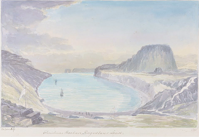
In Christmas Harbour, Kerguelen's Land, watercolor
The hill
The Table de l'Oiseau (403m - 1,322 ft) (Table ot the Bird) is a hill overlooking Port-Christmas by the north. Port-Christmas is one of the most isolated and difficult to reach points in the archipelagok. Given the distance and especially the rugged topography, the site is almost never reached by land. However, it can be reached by sea after sailing for at least 100 nautical miles (190 km). The baie de l'Oiseau, at the bottom of which it is located, forms the first indentation at the northeast end of the Loranchet peninsula. The bay is closed to the north by Cap Français, to the south by Pointe de l'Arche (seen in the foreground).
While the shores of the bay are mostly rocky and often steep, the bottom is occupied by a strike, about 350 meters long, of black sand resulting from the erosion of the surrounding basaltic rocks. pours into the sea, after having collected runoff water from Mount Havergal on the one hand, and that from the outlet of Rochegude Lake on the other. This lake, located about 500 m from the shore and 40 m above sea level, marks the shoulder that separates Port-Christmas from Ducheyron Bay, to the west.
The anchorage at Port-Christmas allows you to anchor at a depth of 11 meters. It offers relatively safe shelter to sailors who frequent this particularly turbulent ocean sector of the Roaring Forties.
The artist
Lieutenant-Colonel Charles Hamilton Smith, was an English artist, naturalist, antiquary, illustrator, soldier, and... spy as well !. His military career began in 1787, when he studied at the Austrian academy for artillery and engineers at Mechelen and Leuven in Belgium (his native country). Although his military service, which ended in 1820 and included the Napoleonic Wars, saw him travel extensively (including the West Indies, Canada, United States, Southern and Northern Europe and ...Antarctica).
As a prolific self-taught illustrator (over 38,000 drawings!) He left quite an important number of books of beautifully watercolored landscapes taken all around the world. those nooks of watercolors are nowadays in the collections of the Yale Center From British Art. Among them :
- Views of France, Volume I (81 watercolors), Views of France, Volume II (93 watercolors),
- Views of England and Wales, Volume I (82 watercolors), Views of England and Wales, Volume II (74 watercolors),
- Views of Northern Europe, Volume I (68 watercolors), Views of Northern Europe, Volume II (78) watercolors),
- Views of Polar Regions (75 watercolors) (see above)
- Views of Spain, Volume I (69 watercolors), Views of Spain, Volume II (72 watercolors), But one of his noteworthy achievements was an 1800 experiment to determine which color should be used for military uniforms. He is also known in military history circles for Costume of the Army of the British Empire, produced towards the end of the Napoleonic Wars and an accurate depiction of contemporary British uniform.
As an antiquarian, he also produced, in collaboration with Samuel Rush Meyrick, Costume of the Original Inhabitants of the British Islands, 1815, and The Ancient Costume of England, with historical illustrations of medieval knights, ladies, shipsm and battles.
He also wrote on the history of the Seven Years' War and The Natural history of dogs.
Quite a productive fellow !
___________________________________________
2022 - Wandering Vertexes...
by Francis Rousseau
