google.com, pub-0288379932320714, DIRECT, f08c47fec0942fa0 GRAVIR LES MONTAGNES... EN PEINTURE: Search results for Thomas Hill
Showing posts sorted by relevance for query Thomas Hill. Sort by date Show all posts

Friday, August 2, 2019

MOUNT BARKER BY EUGENE VON GUERARD


EUGENE VON GUERARD (1811-1901)
Mount Barker  (517 m - 1,696 ft)
Australia 

In Mount Barker and the Murray Plains from top of Mt Lofty, near Adelaide, 1858  
 Pen and ink and wash over pencil, 31.6 × 49.1 cm,
National Gallery of Victoria, Melbourne


The mountain
Mount Barker   (517 m - 1,696 ft) is a hill in the Mount Lofty Ranges in South Australia and namesake of the nearby town of Mount Barker.  Mount Barker was first sighted by Captain Charles Sturt in 1830, although he thought he was looking at the previously discovered Mount Lofty. Captain Collet Barker fixed this error when he surveyed the area in 1831. Sturt named the mountain in honor of Captain Barker after he was killed days later by Aborigines.
The first Europeans to ascend the mountain, on 27 November 1837, were a six-man party comprising John Barton Hack, John Morphett, Samuel Stephens, Charles Stuart (South Australian Company's stock overseer), Thomas Davis (Hack's stockman), and John Wade (a "gentleman from Hobart Town").
There are numerous activities such as walking trails on Mt Barker.This hill is nowadays the home to a transmission tower that services SAGRN and mobile phone transmissions throughout the area. Microwave radio equipment is also installed on the tower, providing various forms of communication such as broadband internet connections and voice services to Mount Barker residents and businesses.

The painter 
Johann Joseph Eugene von Guerard was an Austrian-born artist, active in Australia from 1852 to 1882. Known for his finely detailed landscapes in the tradition of the Düsseldorf school of painting, he is represented in Australia's major public galleries, and is referred to in the country as Eugene von Guerard. In 1852 von Guerard arrived in Victoria, Australia, determined to try his luck on the Victorian goldfields. As a gold-digger he was not very successful, but he did produce a large number of intimate studies of goldfields life, quite different from the deliberately awe-inspiring landscapes for which he was later to become famous. Realizing that there were opportunities for an artist in Australia, he abandoned the diggings and was soon undertaking commissions recording the dwellings and properties of wealthy pastoralists.
By the early 1860s, von Guerard was recognized as the foremost landscape artist in the colonies, touring Southeast Australia and New Zealand in pursuit of the sublime and the picturesque.  He is most known for the wilderness paintings produced during this time, which are remarkable for their shadowy lighting and fastidious detail.  Indeed, his View of Tower Hill in south-western Victoria was used as a botanical template over a century later when the land, which had been laid waste and polluted by agriculture, was systematically reclaimed, forested with native flora and made a state park. The scientific accuracy of such work has led to a reassessment of von Guerard's approach to wilderness painting, and some historians believe it likely that the landscapist was strongly influenced by the environmental theories of the leading scientist Alexander von Humboldt. Others attribute his 'truthful representation' of nature to the criterion for figure and landscape painting set by the Düsseldorf Academy.
_______________________________
2019 - Wandering Vertexes...
by Francis Rousseau 


Friday, December 30, 2022

MONT DIABLO PEINT PAR WILLIAM KEITH


WILLIAM KEITH (1838-1911) Mont Diablo (1 ,173m - 3,648 ft) Etats-Unis (Californie)  In Sunset on Mount Diablo, 1877 ,Huile sur toile,  100.7 cm x 151.5 cm. Cantor Arts Center, Stanford University, Palo Alto CA


WILLIAM KEITH (1838-1911)
Mont Diablo (1 ,173m - 3,648 ft)
Etats-Unis (Californie)

In Sunset on Mount Diablo, 1877 Huile sur toile, 100.7 cm x 151.5 cm.
Cantor Arts Center, Stanford University, Palo Alto CA


Le peintre
William Keith était un peintre américano- écossais célèbre pour ses paysages californiens. Il est associé au tonalisme et à l'Ecole de Barbizon. Bien que la majeure partie de sa carrière se soit déroulée en Californie, il a c effectué deux longs voyages d'études en Europe et a eu un studio à Boston en 1871-72 et un à New York en 1880.
Dans les années 1870, Keith est arrivé en Californie, dans la vallée de Yosemite, avec une lettre de recommandation auprès de John Muir. Les deux hommes sont devenus de grands amis et cette amitié a perduré les 38 années du reste de leur vie . Tous deux étaient nés en Écosse la même année et partageaient un amour pour les montagnes de Californie. James Mitchell Clarke a décrit leur amitié comme une amitié "dans laquelle une affection et une admiration profondes s'exprimaient à travers une sorte de joute verbale, permanente ".
Au cours des années 1870, Keith a peint un certain nombre de grandes œuvres panoramiques dont Kings River Canyon (Oakland Museum) et California Alps (Mission Inn, Riverside). Ces oeuvre voulaient directement rivaliser avec celles de sujet similaires peint par Albert Bierstadt ou Thomas Hill.
"Mes images sont celles qui viennent de l'intérieur.de moi. Je ressens une émotion et je peins immédiatement une image qui l'exprime. Le sentiment est la valeur réelle dans mes images, et seules quelques personnes comprennent cela. Quiconque sait utiliser de la peinture et des pinceaux peut peindre une vraie scène de la nature - c'est une image objective. Mais pour un artiste digne de ce nom, tout doit cela doit venir de l'intérieur de lui même " .

La montagne
Le mont Diablo (1 ,173m - 3,648 ft) est une montagne située dans le comté de Contra Costa dans la région urbaine de San Francisco, au sud de la ville de Clayton et au nord-ouest de Danville. Ce sommet isolé est visible de l'ensemble de la baie de San Francisco et de nombreux endroits de la Californie du Nord. Le mont Diablo ressemble à une double pyramide sous de nombreux angles, et inclut plusieurs sommets secondaires, le plus important et le plus proche étant celui de l'autre moitié de ladite double pyramide, North Peak. Le sommet du mont Diablo est accessible aux véhicules motorisés, randonneurs ou cyclistes. Par temps clair, il est possible du sommet d'apercevoir le massif montagneux de la Sierra Nevada et la montagne de l'extrémité sud de la chaîne des Cascades, le volcan du pic Lassen, à environ 290 kilomètres. Le mont Shasta reste invisible du fait de la courbure terrestre, mais le Half Dome du parc national de Yosemite est lui visible par temps exceptionnellement clair grâce à un télescope.

 _________________________________________

2022 - Wandering Vertexes ....
            Errant au-dessus des Sommets Silencieux...
            Un blog de Francis Rousseau

Sunday, August 22, 2021

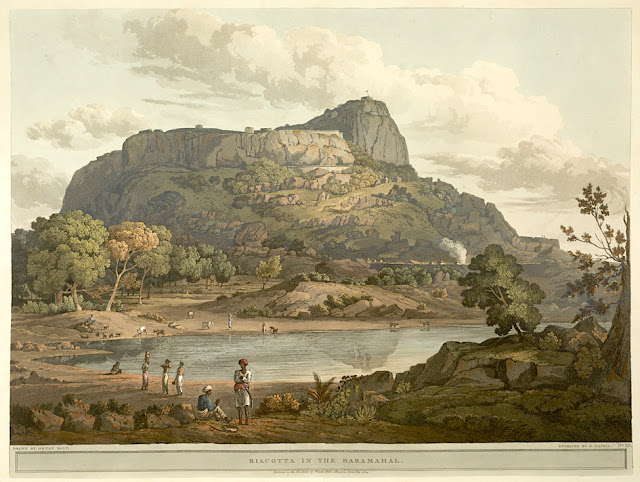
RAYAKOTTAI BY HENRY SALT


HENRY SALT (1780-1827) Rayakottai (No elevation data) India (Tamil Nadu)  In " Riacotta in the Baramahal,' aquatint, from

HENRY SALT (1780-1827)
Rayakottai (No elevation data)
India (Tamil Nadu)

In " Riacotta in the Baramahal,' aquatint, 1806, from  
Twenty Four Views in St. Helena, the Cape, India, Ceylon, the Red Sea, Abyssinia and Egypt, 
 The British Library


About the plate
This aquatint was taken from plate 12 of Henry Salt's Twenty Four Views in St. Helena, the Cape, India, Ceylon, the Red Sea, Abyssinia and Egypt. Salt visited Rayakottai in Tamil Nadu on his way to the Cauvery Falls. Viscount Valentia George Annesley wrote of its importance as a point of communication between Mysore and the Carnatic: "[Governor General] Lord Cornwallis ... had the fortifications strengthened. At present they consist of the hill, whose top is only approachable by a narrow flight of steps, and a fort at the bottom where are very comfortable houses for the officers. The scenery is wild and abrupt, consisting of rocky hills, with woods and jungle between ... the climate is so moderate, that every kind of fruit and vegetable may be reared in a degree of perfection that is unknown on the sultry plains around Madras.". For some reason, this impressed the british  by the fact it was " as high as a mountain". So.... do I year mountain ?

The place
Rayakottai, also spelled Rayakotta is not not really what we can alled a mountain, but a hill or a ridge like there are many others in this blog.  In reality it is a fort ! But it is designed quite like a mountain !!! It is located neat a town in Denkanikottai taluk, Krishnagiri District, Tamil Nadu, India. It is 73 kilometres (45 mi) from Bangalore.  The fort was built by King Krishna deverayar and situated within the town of Rayakottai which is one of the ancient fortress in the Krishnagiri district. It is now one of the protected monument by the Archaeological Survey of India. In the 18th century Hyder Ali and Tipu sultan captured this fort. The fort was captured by Major Gowdie during the third Anglo-Mysore War in 1791. According to the Treaty of Srirangapatna, this fort came into the hands of the British. 

The artist
Henry Salt was an English artist, traveller, collector of antiquities, diplomat, and Egyptologist.
After a time as a portrait painter, Salt was permitted to travel with the English nobleman George Annesley, Viscount Valentia as his secretary and draughtsman after being recommended by Thomas Simon Butt. They started on an eastern tour in June 1802, traveling on the British East India Company's extra (chartered) ship Minerva to India via the Cape Colony. In 1805, Valentia sent Salt on a journey into the Abyssinian area (now Ethiopia) to meet with the ras of Tigré to open up trade relations on behalf of the English. While visiting there, Salt gained the respect of the ras. He returned to England on 26 October 1806. His journey home took him through Egypt where he met the pasha Mehmet Ali. Salt's paintings from the trip were used in Valentia's Voyages and Travels to India, published in 1809. The originals of all the drawings were kept by Valentia, as also the copper plates after Salt's death. The format and style of the plates is similar to Thomas and William Daniell's work, "Oriental Scenery" (1795-1808).
Salt returned to Ethiopia in 1809 on a government mission to explore trade and diplomatic links with the Tigrayan warlord Ras Wolde Selassie. Upon arrival, he was unable to meet with the king due to unrest in the country, so instead he went to stay with his friend the ras of Tigré. During this venture, Salt took on the side mission of verifying and correcting the information about the region reported by the Scottish traveler, James Bruce many years earlier. Salt came back to England in 1811 with numerous specimens of both plants and animals.

___________________________________________
2021 - Wandering Vertexes...
by Francis Rousseau


Sunday, March 8, 2020

MOUNT TABOR BY CATHERINE TOBIN


CATHERINE TOBIN (1855-1903)
Mount Tabor (575 m -1,886 ft)
Israel (Galilee)
In  Mont Tabor, engraving, Israel British Library
 
The mountain
Mount Tabor (575 m - 1,886 ft), (not to be confused with Mount Thabor int he French Alps) is located in Lower Galilee, Israel, at the eastern end of the Jezreel Valley, 11 miles (18 km) west of the Sea of Galilee. Mount Tabor is a Inselberg : an isolated hill or small mountain rising abruptly from gently sloping or level surrounding land, and is not volcanic.
In the Hebrew Bible (Joshua, Judges), Mount Tabor is the site of the Battle of Mount Tabor between the Israelite army under the leadership of Barak and the army of the Canaanite king of Hazor, Jabin, commanded by Sisera.
In Christian tradition, Mount Tabor is the site of the Transfiguration of Jesus.
Mount Tabor is shaped almost like half a sphere, suddenly rising from rather flat surroundings and dominating the town in the plain below, Kfar Tavor. At the top of the mountain are two Christian monasteries, one Greek Orthodox on the northeast side and one Roman Catholic on the southeast side. The Catholic church at the top is easily visible from afar.
At the base it is almost fully surrounded by the Arab villages of Daburiyya, Shibli, and Umm al-Ghanam. Mount Tabor is located off Highway 65, and its summit is accessible by road via Shibli. A hiking tracks starts from the Bedouin village Shibli and is about five kilometers long. It is part of the Israel National Trail.

The artist
Catherine Tobin (died 1903) was a Victorian era author and artist who travelled with her husband and wrote books around the experiences as well as translator for a book on the area. She married Thomas Tobin on 12 September 1835 and with whom she had one son.  However Tobin and her husband shared an interest in travel and antiquities and spent considerable time in the middle and near east. She wrote a number of books due to this interest and travel as well as translating another. At home in Cork, Tobin was a patron of the South Infirmary Victoria University Hospitalfor many years.
George Kelleher has suggested that while Thomas Tobin was an 'antiquarian and curio collector in the spirit of the Victorian age', his wife Catherine, 'was a far more considerable cultural figure'. Her work has served as the basis for a number of studies about the regions.

_____________________________

2020 - Wandering Vertexes...
by Francis Rousseau

Sunday, October 24, 2021

ILLINIZAS VOLCANOES SKETCHED BY FREDERIC EDWIN CHURCH (1826-1900)

FREDERIC EDWIN CHURCH (1826-1900), Illiniza Sur  (5,248 m-17, 218ft) Illiniza Norte 5,126 m-16, 818ft) Ecuador   In Mount Iliniza, Ecuador, July 3, 1857,  Graphite, brush and white gouache on green paper, 31.1 x 43.2 cm, Smithsonian / Cooper Hewitt, Smithsonian Design Museum

FREDERIC EDWIN CHURCH (1826-1900),
Illiniza Sur  (5,248 m-17, 218ft)
Illiniza Norte 5,126 m-16, 818ft)
Ecuador

 In Mount Iliniza, Ecuador, July 3, 1857,  Graphite, brush and white gouache on green paper, 31.1 x 43.2 cm, Smithsonian / Cooper Hewitt, Smithsonian Design Museum 


The volcanoes
The Illinizas are a pair of volcanic mountains that are located to the south of Quito, Ecuador. They are located in the Illinizas Ecological Reserve (Reserva Ecológica Los Illinizas). These twin mountains are separated by a saddle that is about a kilometer long. The peaks are among the highest in Ecuador, with Illiniza Sur (5248 m-17, 218ft) standing slightly taller than Illiniza Norte 5126 m- 16, 818ft) its northern counterpart.
Most guidebooks (for example, Lonely Planet Ecuador, Ecuador: A Climbing Guide) spell the mountain with only one "l" as in Iliniza. The name Illinizas is derived from the Kunza words for "masculine hill."
Whilst Illiniza Sur (the southern peak) is a more difficult climb due to its glacial nature, Illiniza Norte requires little or no climbing expertise, and may be climbed as a trekking peak. A guide is still recommended, however, as the path becomes hard to navigate as it approaches the summit.
The Illinizas are excellent mountains for acclimatization to altitude, and are frequently used as a preparatory climb to higher peaks such as Cotopaxi, Chimborazo and Cayambe.
There is a rustic refuge located between the north and south peaks. It can be reached in one hour by car from El Chaupi, followed by a three-hour climb. The refuge has gas stoves, pots and pans and bunk beds. It is necessary to bring warm sleeping bags and food, but water is available to be boiled. The Englishman Edward Whymper tried and failed twice to make the first ascent of Iliniza Sur. It was climbed for the first time in 1880 by his two Italian guides Jean-Antoine Carrel and Louis Carrel. The first ascent of Iliniza Norte was made in 1912 by the Ecuadorians Nicolás Martínez and Alejandro Villavicencio.


The painter

Frederic Edwin Church was an American landscape painter born in Hartford, Connecticut. He was a central figure in the Hudson River School of American landscape painters, perhaps best known for painting large panoramic landscapes, often depicting mountains, waterfalls, and sunsets, but also sometimes depicting dramatic natural phenomena that he saw during his travels to the Arctic and Central and South America. Church's paintings put an emphasis on light and a romantic respect for natural detail. In his later years, Church painted classical Mediterranean and Middle Eastern scenes and cityscapes.
Church was the product of the second generation of the Hudson River School and the pupil of Thomas Cole, the school’s founder. The Hudson River School was established by the British Thomas Cole when he moved to America and started painting landscapes, mostly of mountains and other traditional American scenes. Both Cole and Church were devout Protestants and the latter's beliefs played a role in his paintings especially his early canvases. Church did differ from Cole in the topics of his paintings: he preferred natural and often majestic scenes over Cole's propensity towards allegory.
Church, like most second generation Hudson River School painters, used extraordinary detail, romanticism, and luminism in his paintings. Romanticism was prominent in Britain and France in the early 1800s as a counter-movement to the Enlightenment virtues of order and logic. Artists of the Romantic period often depicted nature in idealized scenes that depicted the richness and beauty of nature, sometimes also with emphasis on the grand scale of nature.
This tradition carries on in the works of Frederic Church, who idealizes an uninterrupted nature, highlighted by creating excruciatingly detailed art. The emphasis on nature is encouraged by the low horizontal lines, and preponderance of sky to enhance the wilderness; humanity, if it is represented, is depicted as small in comparison with the greater natural reality. The technical skill comes in the form of luminism, a Hudson River School innovation particularly present in Church's works. Luminism is also cited as encompassing several technical aspects, which can be seen in Church’s works. One example is the attempt to “hide brushstrokes,” which makes the scene seem more realistic and lessen the artist’s presence in the work. Most importantly is the emphasis on light (hence luminism) in these scenes. The several sources of light create contrast in the pictures that highlights the beauty and detailed imagery in the painting.

___________________________________________
2021 - Wandering Vertexes...
by Francis Rousseau


Sunday, October 22, 2017

MOUNT SNOWDON BY RICHARD WILSON


RICHARD WILSON  (1714-1782)
Mount Snowdon (1, 085 m -3,560 ft) 
United Kingdom (Wales)

In Mount Snowdon from Llyn Nantlle, oil on canvas, 1765-66,Walker Art Gallery

The mountain 
Mount Snowdon (1, 085 m -3,560 ft),Yr Wyddfa in welsh, is the highest mountain in Wales and the highest point in the British Isles south of the Scottish Highlands. A 1682 survey estimated that the summit of Snowdon was at a height of 1,130 m - 3,720 feet ; in 1773, Thomas Pennant quoted a later estimate of 1,088 m- 3,568 ft above sea level at Caernarfon. Recent surveys give the height of the summit as 1,085 m -3,560 ft. The name Snowdon is from the Old English for "snow hill", while the Welsh name – Yr Wyddfa – means "the tumulus" or "the barrow", which may refer to the cairn thrown over the legendary giant Rhitta Gawr after his defeat by King Arthur. As well as other figures from Arthurian legend, the mountain is linked to a legendary Afanc (water monster) and the Tylwyth Teg (fairies). Mount Snowdon is located in Snowdonia National Park (Parc Cenedlaethol Eryri) in Gwynedd. It has been described as "probably the busiest mountain in Britain", with approximately 444,000 people having walked up the mountain in 2016.  It is designated as a national nature reserve for its rare flora and fauna. The rocks that form Snowdon were produced by volcanoes in the Ordovician period, and the massif has been extensively sculpted by glaciation, forming the pyramidal peak of Snowdon and the Arêtes of Crib Goch and Y Lliwedd. The cliff faces on Snowdon, including Clogwyn Du'r Arddu, are significant for rock climbing, and the mountain was used by Edmund Hillary in training for the 1953 ascent of Mount Everest.
The summit can be reached by a number of well-known paths, and by the Snowdon Mountain Railway, a rack and pinion railway opened in 1896 which carries passengers the 4.7 miles (7.6 km) from Llanberis to the summit station.

The Painter 
Richard Wilson RA was an influential Welsh landscape painter, who worked in Britain and Italy. With George Lambert he is recognised as a pioneer in British art of landscape for its own sake and was described in the Welsh Academy Encyclopedia of Wales as the "most distinguished painter Wales has ever produced and the first to appreciate the aesthetic possibilities of his country".  In December 1768 Wilson became one of the founder-members of the Royal Academy. A catalogue raisonné of the artist's work is published by the Paul Mellon Centre for Studies in British Art.
From 1750 to 1757 Wilson was in Italy, and became a landscape painter on the advice of Francesco Zuccarelli. Painting in Italy and afterwards in Britain, he was the first major British painter to concentrate on landscape. He composed well, but saw and rendered only the general effects of nature, thereby creating a personal, ideal style influenced by Claude Lorrain and the Dutch landscape tradition. John Ruskin wrote that Wilson "paints in a manly way, and occasionally reaches exquisite tones of colour".  He concentrated on painting idealised Italianate landscapes and landscapes based upon classical literature, but when his painting, The Destruction of the Children of Niobe (c.1759–60), won acclaim, he gained many commissions from landowners seeking classical portrayals of their estates. Among Wilson's pupils was the painter Thomas Jones. His landscapes were acknowledged as an influence by Constable, John Crome and Turner.

Saturday, October 1, 2016

TABLE MOUNTAIN PAINTED BY WILLIAM HODGES


WILLIAM HODGES (1744-1797) 
Table mountain or Hoerikwaggo (1,085 m - 3,558 ft)  
South Africa

In Table mountain as seen from on board HMS Resolution' captain Cook, 1772, oil on canvas 

The mountain 
Table Mountain also called Hoerikwaggo is a flat-topped mountain forming a prominent landmark overlooking the city of Cape Town in South Africa and  forming part of the Table Mountain National Park.  The main feature of Table Mountain is the level plateau approximately 3 kilometres (2 mi) from side to side, edged by impressive cliffs. The plateau, flanked by Devil's Peak to the east and by Lion's Head to the west, forms a dramatic backdrop to Cape Town. This broad sweep of mountainous heights, together with Signal Hill, forms the natural amphitheatre of the City Bowl and Table Bay harbour. The highest point on Table Mountain is towards the eastern end of the plateau and is marked by Maclear's Beacon, a stone cairn built in 1865 by Sir Thomas Maclear for trigonometrical survey. It is 1,086 metres (3,563 ft) above sea level, about 19 metres (62 ft) higher than the cable station at the western end of the plateau.
The cliffs of the main plateau are split by Platteklip Gorge ("Flat Stone Gorge"), which provides an easy and direct ascent to the summit and was the route taken by Antуnio de Saldanha on the first recorded ascent of the mountain in 1503.
The flat top of the mountain is often covered by orographic clouds, formed when a south-easterly wind is directed up the mountain's slopes into colder air, where the moisture condenses to form the so-called "table cloth" of cloud. Legend attributes this phenomenon to a smoking contest between the Devil and a local pirate called Van Hunks. When the table cloth is seen, it symbolizes the contest.
Table Mountain is at the northern end of a sandstone mountain range that forms the spine of the Cape Peninsula. To the south of the main plateau is a lower part of the range called the Back Table. On the Atlantic coast of the peninsula, the range is known as the Twelve Apostles. The range continues southwards to Cape PointTable Mountain is featured in the Flag of Cape Town and other local government insignia. It is a significant tourist attraction, with many visitors using the cableway or hiking to the top. 
Source:

The painter 
William Hodges was an English painter, member of James Cook's second voyage to the Pacific Ocean, and best known for the sketches and paintings of locations he visited on that voyage, including Table Bay, Tahiti, Easter Island, and the Antarctic.
 He studied under William Shipley, and afterwards in the studio of Richard Wilson, where he met Thomas Jones.
Between 1772 and 1775 Hodges accompanied James Cook to the Pacific as the expedition's artist. Many of his sketches and wash paintings were adapted as engravings in the original published edition of Cook's journals from the voyage.
Most of the large-scale landscape oil paintings from his Pacific travels for which Hodges is best known were finished after his return to London; he received a salary from the Admiralty for the purposes of completing them. These paintings depicted a stronger light and shadow than had been usual in European landscape tradition. Contemporary art critics complained that his use of light and colour contrasts gave his paintings a rough and unfinished appearance.
In 1778, under the patronage of Warren Hastings, Hodges travelled to India, one of the first British professional landscape painters to visit that country. He remained there for six years, staying in Lucknow with Claude Martin in 1783. His painting of "Futtypoor Sicri" is in Sir John Soane's Museum.
Later Hodges travelled also across Europe, including a visit to St. Petersburg in Russia in 1790.
In 1793 Hodges published an illustrated book about his travels in India.
In late 1794 Hodges opened an exhibition of his own works in London that included two large paintings called The Effects of Peace and The Effects of War.  In late January, 1795, with Britain engaged in the War of the First Coalition against Revolutionary France and feelings running high, the exhibition was visited by Prince Frederick, Duke of York and Albany, the second son of King George III. The Duke took offence at the political nature of Hodges' paintings and ordered the exhibition closed; this royal censure effectively ended Hodges' career as a painter.
Hodges retired to Devon and became involved with a bank, which failed during the banking crisis of March, 1797. On 6 March of that year, he died from what was officially recorded as "gout in the stomach", but which was also rumoured to be suicide from an overdose of laudanum.
Hodges Knoll in Antarctica is named after William Hodges.
Source:

Friday, November 25, 2016

MOUNT WILLIAM PAINTED BY EUGENE VON GUERARD


EUGENE VON GUERARD (1811-1901)
Mount William or Mount Duwil (1, 167 m - 3, 829 ft)
Australia

 In Mount William seen from Mount Dryden,1857, oil on canvas, National Gallery of Australia


The mountain 
Mount William also called  Mount Duwil  (1, 167 m - 3, 829 ft) is the highest point within the Grampians Mountain Range, (Grampians National Park) in the Australian state of Victoria. The mountain is situated approximately 250 kilometres (160 mi) west-north-west of Melbourne on the eastern edge of the national park, approximately 22 kilometres (14 mi) drive from Halls Gap.
In 1836, sir Thomas Mitchell  was the first man to reached the summit with a group of explorers i. The first settler in the area was Horatio Wills, who established a sheep run at Mount William in 1840, and named nearby Mount Ararat, after which the town is named. His son, cricketer and Australian rules football pioneer Tom Wills, grew up as a lone white child among the Djab wurrung Aboriginal tribes of Mount William. Three transmission towers are located at the summit of Mount William including an amateur radio repeater. A sealed service road continues to the summit, but is not accessible by vehicle to the general public.
Visitors to the mountain can drive to a carpark located approximately 920 metres (3,020 ft) up the mountain, before proceeding on foot for 1.8 kilometres (1.1 mi) to the summit. It will take a person of moderate fitness approximately 45 mins to walk. No permit is required to climb the mountain.
Source: 
- Grampians National Park 

The painter 
Johann Joseph Eugene von Guerard was an Austrian-born artist, active in Australia from 1852 to 1882. Known for his finely detailed landscapes in the tradition of the Düsseldorf school of painting, he is represented in Australia's major public galleries, and is referred to in the country as Eugene von Guerard. In 1852 von Guerard arrived in Victoria, Australia, determined to try his luck on the Victorian goldfields. As a gold-digger he was not very successful, but he did produce a large number of intimate studies of goldfields life, quite different from the deliberately awe-inspiring landscapes for which he was later to become famous. Realizing that there were opportunities for an artist in Australia, he abandoned the diggings and was soon undertaking commissions recording the dwellings and properties of wealthy pastoralists.
By the early 1860s, von Guerard was recognized as the foremost landscape artist in the colonies, touring Southeast Australia and New Zealand in pursuit of the sublime and the picturesque.  He is most known for the wilderness paintings produced during this time, which are remarkable for their shadowy lighting and fastidious detail.  Indeed, his View of Tower Hill in south-western Victoria was used as a botanical template over a century later when the land, which had been laid waste and polluted by agriculture, was systematically reclaimed, forested with native flora and made a state park. The scientific accuracy of such work has led to a reassessment of von Guerard's approach to wilderness painting, and some historians believe it likely that the landscapist was strongly influenced by the environmental theories of the leading scientist Alexander von Humboldt. Others attribute his 'truthful representation' of nature to the criterion for figure and landscape painting set by the Düsseldorf Academy.
In 1866 his Valley of the Mitta Mitta was presented to the National Gallery of Victoria in Melbourne; in 1870 the trustees purchased his Mount Kosciusko shown in this article was titled "Northeast view from the northern top of Mount Kosciusko", which is actually  "from Mount Townsend".
In 2006, the City of Greater Geelong purchased his 1856 painting View of Geelong for A$3.8M. His painting, Yalla-y-Poora, is in the Joseph Brown Collection on display at the National Gallery of Victoria.  The State Library of New South Wales in Sydney holds an extensive collection of working sketchbooks by Eugene von Guerard, as well as larger drawings and paintings and a diary. The sketchbooks cover regions as diverse as Italy and Germany, Tasmania, New South Wales, and of course, Victoria.
In 1870 von Guerard was appointed the first Master of the School of Painting at the National Gallery of Victoria, where he was to influence the training of artists for the next 11 years. His reputation, high at the beginning of this period, had faded somewhat towards the end because of his rigid adherence to picturesque subject matter and detailed treatment in the face of the rise of the more intimate Heidelberg School style. Amongst his pupils were Frederick McCubbin and Tom Roberts. Von Guerard retired from his position at the National Gallery School the end of 1881 and departed for Europe in January 1882. In 1891 his wife died. Two years later, he lost his investments in the Australian bank crash and he lived in poverty until his death in Chelsea, London, on 17 April 1901.
Several paintings of mountains of Australia and New Zealand by Eugène von Guerard are published in this blog....
Sources: 
- Dictionnary of Australian Artists, Oxford University Press, 1992


Saturday, November 16, 2019

MOUNT LANGI GHIRAN BY EUGENE VON GUERARD


EUGENE VON GUERARD (1811-1901) 
Mount Langi Ghiran (924m - 3,031ft) 
Australia (Victoria) 

In Mount Langi Ghiran, oil on canvas, 1890

The mountain 
Mount Langi Ghiran (924m - 3,031ft) is located in the west of Victoria  southeast of Australia. The nearest town to Mount Langi Ghiran is Ararat about 16.3 km away. 
The first European to climb Mount Langi Ghiran was Major Thomas Mitchell, on his 1836 'Australia Felix' expedition.  He first named it Mount Mistake ! 
There are two reservoirs in the park which were built from local granite blocks in the 1880s. The main reservoir forms part of Ararat's water supply and is worth a visit.
A "spot mill" for extracting timber was built on the northern slopes in 1940 but was short lived. Today little evidence remains to remind us of the mill's past operation.
Since 1970,  famous vineyards are situated in the valley of Mount Langi Ghiran.

The painter
Johann Joseph Eugene von Guerard was an Austrian-born artist, active in Australia from 1852 to 1882. Known for his finely detailed landscapes in the tradition of the Düsseldorf school of painting, he is represented in Australia's major public galleries, and is referred to in the country as Eugene von Guerard. In 1852 von Guerard arrived in Victoria, Australia, determined to try his luck on the Victorian goldfields. As a gold-digger he was not very successful, but he did produce a large number of intimate studies of goldfields life, quite different from the deliberately awe-inspiring landscapes for which he was later to become famous. Realizing that there were opportunities for an artist in Australia, he abandoned the diggings and was soon undertaking commissions recording the dwellings and properties of wealthy pastoralists.
By the early 1860s, von Guerard was recognized as the foremost landscape artist in the colonies, touring Southeast Australia and New Zealand in pursuit of the sublime and the picturesque. He is most known for the wilderness paintings produced during this time, which are remarkable for their shadowy lighting and fastidious detail. Indeed, his View of Tower Hill in south-western Victoria was used as a botanical template over a century later when the land, which had been laid waste and polluted by agriculture, was systematically reclaimed, forested with native flora and made a state park. The scientific accuracy of such work has led to a reassessment of von Guerard's approach to wilderness painting, and some historians believe it likely that the landscapist was strongly influenced by the environmental theories of the leading scientist Alexander von Humboldt. Others attribute his 'truthful representation' of nature to the criterion for figure and landscape painting set by the Düsseldorf Academy.

_______________________________
2019 - Wandering Vertexes...
by Francis Rousseau

Saturday, January 14, 2017

MOUNT LAFAYETTE PAINTED BY ALBERT BIERSTADT


ALBERT BIERSTADT (1830-1902) 
Mount Lafayette (1,600m - 5,249 ft) 
United State of America 

The Mountain 
Mount Lafayette (1,600m - 5,249 ft)  is a mountain at the northern end of the Franconia Range in the White Mountains of New Hampshire, United States. It is located in the town of Franconia in Grafton County. It is on the New England Fifty Finest list of the most topographically prominent peaks in New England. The upper portion of the mountain is located in the alpine zone, an area where only small vegetation exists due to the harsh climate.
The mountain is named to honor General Lafayette, a French military hero of the 18th century who fought with and significantly aided the Continental Army and was loved and adopted by George Washington during the American Revolutionary War. Lafayette re-visited New Hampshire and all the other states in an extremely popular, triumphal tour during 1824-1825, celebrating the 50th anniversary of the Battle of Bunker Hill.
Mount Lafayette is the highest point in the Franconia Range, a line of peaks along the east side of Franconia Notch. It is the sixth highest peak in New Hampshire and the highest outside of the Presidential Range. It is the second most prominent peak in the state. On the western side, its lower slopes lie inside Franconia Notch State Park. The remainder of the mountain lies within the White Mountain National Forest. The summit marks the western border of the Pemigewasset Wilderness Area within the WMNF.

The painter 
Albert Bierstadt was a German-born American painter. He was brought to the United States at the age of one by his parents. He later returned to study painting for several years in Düsseldorf. At an early age Bierstadt developed a taste for art and made clever crayon sketches in his youth. 
In 1851, he began to paint in oils. He became part of the Hudson River School in New York, an informal group of like-minded painters who started painting along this scenic river. Their style was based on carefully detailed paintings with romantic, almost glowing lighting, sometimes called luminism. An important interpreter of the western landscape, Bierstadt, along with Thomas Moran, is also grouped with the Rocky Mountain School.
In 1858 he exhibited a large painting of a Swiss landscape at the National Academy of Design, which gained him positive critical reception and honorary membership in the Academy.  At this time Bierstadt began painting scenes in New England and upstate New York, including in the Hudson River valley. A group of artists known as the Hudson River School portrayed its majestic landscapes and craggy areas, as well as the light affected by the changing waters.
In 1859, Bierstadt traveled westward in the company of Frederick W. Lander, a land surveyor for the U.S. government, to see those landscapes.  He continued to visit the American West throughout his career.
During the American Civil War, Bierstadt paid for a substitute to serve in his place when he was drafted in 1863. He completed one Civil War painting Guerrilla Warfare, Civil War in 1862, based on his brief experiences with soldiers stationed at Camp Cameron in 1861.
Bierstadt's painting was based on a stereoscopic photograph taken by his brother Edward Bierstadt, who operated a photography studio at Langley's Tavern in Virginia. Bierstadt's painting received a positive review when it was exhibited at the Brooklyn Art Association at the Brooklyn Academy of Music in December 1861. Curator Eleanor Jones Harvey observes that Bierstadt's painting, created from photographs, "is quintessentially that of a voyeur, privy to the stories and unblemished by the violence and brutality of first-hand combat experience."
In 1860, he was elected a member of the National Academy; he received medals in Austria, Bavaria, Belgium, and Germany.[ In 1867 he traveled to London, where he exhibited two landscape paintings in a private reception with Queen Victoria. He traveled through Europe for two years, cultivating social and business contacts to sustain the market for his work overseas.
As a result of the publicity generated by his Yosemite paintings, Bierstadt's presence was requested by every explorer considering a westward expedition, and he was commissioned by the Atchison, Topeka, and Santa Fe Railroad to visit the Grand Canyon for further subject matter.
Bierstadt's technical proficiency, earned through his study of European landscape, was crucial to his success as a painter of the American West. It accounted for his popularity in disseminating views of the Rockies to those who had not seen them. The immense canvases he produced after his trips with Lander and Ludlow established him as the preeminent painter of the western American landscape. 
Despite his popular success, Bierstadt was criticized by some contemporaries for the romanticism evident in his choices of subject and his use of light was felt to be excessive. 
In 1882 Bierstadt's studio at Irvington, New York, was destroyed by fire, resulting in the loss of many of his paintings. By the time of his death on February 18, 1902, the taste for epic landscape painting had long since subsided. Bierstadt was then largely forgotten. He was buried at the Rural Cemetery in New Bedford, Massachusetts.
Interest in his work was renewed in the 1960s, with the exhibition of his small oil studies. The subsequent reassessment of Bierstadt's work has placed it in a favorable context.
Bierstadt's theatrical art, fervent sociability, international outlook, and unquenchable personal energy reflected the epic expansion in every facet of western civilization during the second half of the nineteenth century. Bierstadt was a prolific artist, having completed over 500 paintings during his lifetime. Many of these are held by museums across the United States.
Several mountain paintings by Bierstadt are published in this blog.  To find them, go to his name in the column on the right and just click on his name.
Sources: 

Sunday, May 5, 2019

MOUNT SNOWDON PAINTED BY SIR KYFFIN WILLIAMS


SIR KYFFIN WILLIAMS (1918-2006)
Mount Snowdon (1, 085 m -3,560 ft) 
United Kingdom (Wales)

The mountain
Mount Snowdon (1, 085 m -3,560 ft),Yr Wyddfa in welsh, is the highest mountain in Wales and the highest point in the British Isles south of the Scottish Highlands. A 1682 survey estimated that the summit of Snowdon was at a height of 1,130 m - 3,720 feet ; in 1773, Thomas Pennant quoted a later estimate of 1,088 m- 3,568 ft above sea level at Caernarfon. Recent surveys give the height of the summit as 1,085 m -3,560 ft. The name Snowdon is from the Old English for "snow hill", while the Welsh name – Yr Wyddfa – means "the tumulus" or "the barrow", which may refer to the cairn thrown over the legendary giant Rhitta Gawr after his defeat by King Arthur. As well as other figures from Arthurian legend, the mountain is linked to a legendary Afanc (water monster) and the Tylwyth Teg (fairies). Mount Snowdon is located in Snowdonia National Park (Parc Cenedlaethol Eryri) in Gwynedd. It has been described as "probably the busiest mountain in Britain", with approximately 444,000 people having walked up the mountain in 2016. It is designated as a national nature reserve for its rare flora and fauna. The rocks that form Snowdon were produced by volcanoes in the Ordovician period, and the massif has been extensively sculpted by glaciation, forming the pyramidal peak of Snowdon and the Arêtes of Crib Goch and Y Lliwedd. The cliff faces on Snowdon, including Clogwyn Du'r Arddu, are significant for rock climbing, and the mountain was used by Edmund Hillary in training for the 1953 ascent of Mount Everest.
The summit can be reached by a number of well-known paths, and by the Snowdon Mountain Railway, a rack and pinion railway opened in 1896 which carries passengers the 4.7 miles (7.6 km) from Llanberis to the summit station.

The painter
Sir John "Kyffin" Williams, KBE, RA was a Welsh landscape painter who lived at Pwllfanogl, Llanfairpwll, on the Island of Anglesey. Williams is widely regarded as the defining artist of Wales during the 20th century.
His works typically drew inspiration from the Welsh landscape and farmlands. His works may be seen in a permanent exhibition in the Oriel Kyffin Williams Gallery which opened in 2008 at Oriel Ynys Môn in Llangefni, Anglesey, as well as at many other galleries elsewhere in Britain. He was president of the Royal Cambrian Academy and was appointed a member of the Royal Academy in 1974. In 1995 Williams received the Glyndŵr Award for an Outstanding Contribution to the Arts in Wales during the Machynlleth Festival. He was awarded the OBE for his services to the arts in 1982 and a KBE in 1999.
The Kyffin Williams Drawing Prize was established in 2009. The winning works from the 2018 prize are due to be exhibited at the Oriel Kyffin Williams Gallery.
In February 2011 it was announced that Williams' paintings of Patagonia would be shown for the first time. His last passport, on show in the Oriel Ynys Môn gallery at Llangefni, 2004–2014, has the name Sir John Williams. Kyffin was his grandmother's maiden name.
Williams' works are held in many public collections, including the Government Art Collection, the Arts Council Collection and the National Museum of Wales.
_____________________________

2019 - Wandering Vertexes...
by Francis Rousseau

Saturday, October 3, 2020

MOUNT LANGI PAINTED BY EUGENE VON GUERARD


EUGENE VON GUERARD (1811-1901) Mount Langi Ghiran (924 m - 3,031ft) Australia (Victoria)  In Mount Langi from Pleasant Creek oil on canvas, 1890

EUGENE VON GUERARD (1811-1901)
Mount Langi Ghiran (924 m - 3,031ft)
Australia (Victoria)

In Mount Langi from Pleasant Creek oil on canvas, 1890


The mountain
Mount Langi Ghiran (924m - 3,031ft) is located in the west of Victoria southeast of Australia. The nearest town to Mount Langi Ghiran is Ararat about 16.3 km away.
The first European to climb Mount Langi Ghiran was Major Thomas Mitchell, on his 1836 'Australia Felix' expedition. He first named it Mount Mistake !
There are two reservoirs in the park which were built from local granite blocks in the 1880s. The main reservoir forms part of Ararat's water supply and is worth a visit.
A "spot mill" for extracting timber was built on the northern slopes in 1940 but was short lived. Today little evidence remains to remind us of the mill's past operation.
Since 1970, famous vineyards are situated in the valley of Mount Langi Ghiran.

The painter

Johann Joseph Eugene von Guerard was an Austrian-born artist, active in Australia from 1852 to 1882. Known for his finely detailed landscapes in the tradition of the Düsseldorf school of painting, he is represented in Australia's major public galleries, and is referred to in the country as Eugene von Guerard. In 1852 von Guerard arrived in Victoria, Australia, determined to try his luck on the Victorian goldfields. As a gold-digger he was not very successful, but he did produce a large number of intimate studies of goldfields life, quite different from the deliberately awe-inspiring landscapes for which he was later to become famous. Realizing that there were opportunities for an artist in Australia, he abandoned the diggings and was soon undertaking commissions recording the dwellings and properties of wealthy pastoralists.
By the early 1860s, von Guerard was recognized as the foremost landscape artist in the colonies, touring Southeast Australia and New Zealand in pursuit of the sublime and the picturesque. He is most known for the wilderness paintings produced during this time, which are remarkable for their shadowy lighting and fastidious detail. Indeed, his View of Tower Hill in south-western Victoria was used as a botanical template over a century later when the land, which had been laid waste and polluted by agriculture, was systematically reclaimed, forested with native flora and made a state park. The scientific accuracy of such work has led to a reassessment of von Guerard's approach to wilderness painting, and some historians believe it likely that the landscapist was strongly influenced by the environmental theories of the leading scientist Alexander von Humboldt. Others attribute his 'truthful representation' of nature to the criterion for figure and landscape painting set by the Düsseldorf Academy.

_______________________________
2020 - Wandering Vertexes...
by Francis Rousseau

Sunday, January 10, 2021

MOUNT SNOWDON FROM LLYN Y DDINAS BY SIDNEY RICHARD PERCY


https://wanderingvertexes.blogspot.com/2021/01/mount-snowdon-from-llyn-y-ddinas-by.html

SIDNEY RICHARD PERCY (1821-1886)
Mount Snowdon (1, 085 m -3,560 ft)
United Kingdom (Wales)

In Llyn-y-Ddinas, North Wales, Mount Snowdon in the background (1873), Oil on canvas, 45.5 x 76 cm. Private Collection

 
The mountain
Mount Snowdon (1, 085 m -3,560 ft),Yr Wyddfa in welsh, is the highest mountain in Wales and the highest point in the British Isles south of the Scottish Highlands. A 1682 survey estimated that the summit of Snowdon was at a height of 1,130 m - 3,720 feet ; in 1773, Thomas Pennant quoted a later estimate of 1,088 m- 3,568 ft above sea level at Caernarfon. Recent surveys give the height of the summit as 1,085 m -3,560 ft. The name Snowdon is from the Old English for "snow hill", while the Welsh name – Yr Wyddfa – means "the tumulus" or "the barrow", which may refer to the cairn thrown over the legendary giant Rhitta Gawr after his defeat by King Arthur. As well as other figures from Arthurian legend, the mountain is linked to a legendary Afanc (water monster) and the Tylwyth Teg (fairies). Mount Snowdon is located in Snowdonia National Park (Parc Cenedlaethol Eryri) in Gwynedd. It has been described as "probably the busiest mountain in Britain", with approximately 444,000 people having walked up the mountain in 2016. It is designated as a national nature reserve for its rare flora and fauna. The rocks that form Snowdon were produced by volcanoes in the Ordovician period, and the massif has been extensively sculpted by glaciation, forming the pyramidal peak of Snowdon and the Arêtes of Crib Goch and Y Lliwedd. The cliff faces on Snowdon, including Clogwyn Du'r Arddu, are significant for rock climbing, and the mountain was used by Edmund Hillary in training for the 1953 ascent of Mount Everest.
The summit can be reached by a number of well-known paths, and by the Snowdon Mountain Railway, a rack and pinion railway opened in 1896 which carries passengers the 4.7 miles (7.6 km) from Llanberis to the summit station.

The painter
Sidney Richard Percy had his greatest success painting landscapes of grazing cattle, typically set against backgrounds of distant mountains and cloudy skies. The prevailing hues of his landscapes are earth tones and soft greens, accentuated by a variety of pastel hues. The detail in his work is part of its appeal, and "it was remarked that his rocks and stones were sufficiently accurate to have served as illustrations to the writings of Sir Roderick Murchison, the popular 19th-century geologist." Llyn-y-Ddinas, North Wales, (see above) one of his more popular works on the internet, displays these qualities. He also painted landscapes of farm fields, wheel-rutted country roads, and the occasional boat scene on a lake. Although he generally painted in oils, a number of small watercolors on cardboard exist, typically unsigned, that are his work. The family, and his son the painter Herbert Sidney Percy in particular, referred to these as "potboilers", meaning that they were quickly, and often crudely executed, yet easily and cheaply sold "to put food on the table" when working on larger, more time-consuming oils for exhibition, or commissions. Many of these watercolor "potboilers" were done in the field, and then brought back to the studio to refer to when executing a more formal oil on canvas.
Sidney Richard Percy was extremely popular during the early part of his career, which for a short time brought him a fair amount of income. Among his patrons during this time was Prince Albert the Royal consort who in 1854 gave Percy's landscape of A view of Llyn Dulyn, North Wales, which had just been exhibited at the Royal Academy, as a gift to his wife Queen Victoria. This painting still hangs today in the Royal Collection. Unfortunately Sidney Richard Percy outlived his popularity, and the art world was more excited about impressionism and other styles than landscapes when he died. Today though, his work is much sought after, and his better paintings bring much higher prices in auction than any of those of his brethren in the Williams family.
When the Athenaeum in 1886 (i. 592) ran an obituary for Sidney Richard Percy they called him, "the well-known and popular painter, founder of the so-called School of Barnes . . ." Although depending on the context of what is meant by the so-called Barnes School, this is a bit of an injustice to his father Edward Williams, whom it might be argued is the founder of the Barnes School of painters, but it illustrates the popularity that Sidney Richard Percy held with the art-buying public of his day.

__________________________________________

2021 - Wandering Vertexes / Mountain paintings
By Francis Rousseau

Monday, January 1, 2018

MOUNT NORQUAY IN VINTAGE POSTCARD 1955


VINTAGE POSTCARD 1955
Mount Norquay (2,133 m - 6,998ft)
Canada (Alberta)

In Ski at Mt Norquay resort, 1955 


The mountain 
Mount Norquay  (2,133 m - 6,998ft)  is located in  Banff National Park, Canada (Alberta), directly northwest of the Town of Banff. Mount Norquay is one of three major ski resorts located in the Banff National Park. The mountain was named in 1904 after John Norquay, premier of Manitoba from 1878 to 1887 which  climbed the mountain.
The first ski runs date as far back as 1926, with the opening of the ski lodge in 1929.  Rope tows were installed in 1942 and the mountain was the first in Canada to install a chair lift in 1948.  Mount Norquay has a long history supporting the sport of alpine ski racing. The Dominion Championships were early efforts by the local community to promote winter tourism and Norquay hosted the Championships on three separate occasions. The resort was part of two Olympic Winter Games bids (1964 and 1968) and did host the World Cup in 1972, running giant slalom and slalom races on the North American run. The resort was also famous for ski jumping, hosting many international competitions. The ski jump is still homologated and was recently used by the Altius Ski Club of Calgary.
Today the Mount Norquay Ski Resort is a popular ski destination and one of the most important ski resorts supporting alpine ski racing in Canada. The ski hill hosts many local events as well as major international ski races. Well-known Canadian ski champions who are members of the Banff Alpine Racers, the home ski club for the resort, are Thomas Grandi and Cary Mullen, as well as current Canadian Alpine Ski Team members Paul Stutz and Erik Read.


Wednesday, September 1, 2021

MOUNT SNOWDON PAINTED BY J.M.W. TURNER


J.M.W. Turner (1775-1851), Mount Snowdon (1, 085 m -3,560 ft), United Kingdom (Wales),  In  "Mount Snowdon, Afterglow ", oil on canvas, 1800, Tate 
 
J.M.W. Turner (1775-1851)
Mount Snowdon (1, 085 m -3,560 ft)
United Kingdom (Wales)

In Mount Snowdon, Afterglow, oil on canvas, 1800, Tate

The mountain
Mount Snowdon (1, 085 m -3,560 ft),Yr Wyddfa in welsh, is the highest mountain in Wales and the highest point in the British Isles south of the Scottish Highlands. A 1682 survey estimated that the summit of Snowdon was at a height of 1,130 m - 3,720 feet ; in 1773, Thomas Pennant quoted a later estimate of 1,088 m- 3,568 ft above sea level at Caernarfon. Recent surveys give the height of the summit as 1,085 m -3,560 ft. The name Snowdon is from the Old English for "snow hill", while the Welsh name – Yr Wyddfa – means "the tumulus" or "the barrow", which may refer to the cairn thrown over the legendary giant Rhitta Gawr after his defeat by King Arthur. As well as other figures from Arthurian legend, the mountain is linked to a legendary Afanc (water monster) and the Tylwyth Teg (fairies). Mount Snowdon is located in Snowdonia National Park (Parc Cenedlaethol Eryri) in Gwynedd. It has been described as "probably the busiest mountain in Britain", with approximately 444,000 people having walked up the mountain in 2016. It is designated as a national nature reserve for its rare flora and fauna. The rocks that form Snowdon were produced by volcanoes in the Ordovician period, and the massif has been extensively sculpted by glaciation, forming the pyramidal peak of Snowdon and the Arêtes of Crib Goch and Y Lliwedd. The cliff faces on Snowdon, including Clogwyn Du'r Arddu, are significant for rock climbing, and the mountain was used by Edmund Hillary in training for the 1953 ascent of Mount Everest.
The summit can be reached by a number of well-known paths, and by the Snowdon Mountain Railway, a rack and pinion railway opened in 1896 which carries passengers the 4.7 miles (7.6 km) from Llanberis to the summit station.

The painter
The english painter Joseph Mallord William Turner was considered a controversial figure in his day, but is now regarded as the artist who elevated landscape painting to an eminence in the history of painting. Although renowned for his oil paintings, Turner is also one of the greatest masters of British watercolour landscape painting.  He is commonly known as "the painter of light" and his work is regarded as a Romantic preface to Impressionism.
In his thirties, Turner travelled widely in Europe, starting with France and Switzerland in 1802 and studying in the Louvre in Paris in the same year. He made many visits to Venice.  Turner's talent was recognized early in his life. Financial independence allowed Turner to innovate freely; his mature work is characterized by a chromatic palette and broadly applied atmospheric washes of paint. According to David Piper's The Illustrated History of Art, his later pictures were called "fantastic puzzles:" Turner was recognized as an artistic genius: influential English art critic John Ruskin described him as the artist who could most "stirringly and truthfully measure the moods of Nature."
Turner's major venture into printmaking was the Liber Studiorum (Book of Studies), seventy prints that he worked on from 1806 to 1819. The Liber Studiorum was an expression of his intentions for landscape art. The idea was loosely based on Claude Lorrain's Liber Veritatis (Book of Truth), where Lorrain had recorded his completed paintings; a series of print copies of these drawings, by then at Devonshire House, had been a huge publishing success. Turner's plates were meant to be widely disseminated, and categorized the genre into six types: Marine, Mountainous, Pastoral, Historical, Architectural, and Elevated or Epic Pastoral. His printmaking was a major part of his output, and a museum is devoted to it, the Turner Museum in Sarasota, Florida, founded in 1974 by Douglass Montrose-Graem to house his collection of Turner prints.
Turner placed human beings in many of his paintings to indicate his affection for humanity on the one hand (note the frequent scenes of people drinking or working or walking in the foreground), but its vulnerability and vulgarity amid the 'sublime' nature of the world on the other. 'Sublime' here means awe-inspiring, savage grandeur, a natural world unmastered by man, evidence of the power of God – a theme that romanticist artists and poets were exploring in this period. Although these late paintings appear to be 'impressionistic' and therefore a forerunner of the French school, Turner was striving for expression of spirituality in the world, rather than responding primarily to optical phenomena.
Turner used pigments like carmine in his paintings, knowing that they were not long-lasting, despite the advice of contemporary experts to use more durable pigments. As a result, many of his colours have now faded greatly.
John Ruskin says in his "Notes" on Turner in March 1878 : "His true master was Dr Monro; to the practical teaching of that first patron and the wise simplicity of method of watercolour study, in which he was disciplined by him and companioned by Girtin, the healthy and constant development of the greater power is primarily to be attributed; the greatness of the power itself, it is impossible to over-estimate. "

_______________________________
2021 - Wandering Vertexes...
by Francis Rousseau

Wednesday, January 8, 2020

TABLE MOUNTAIN / HOERIKWAGGO BY NITA SPILHAUS


 NITA SPILHAUS (1878-1967) 
Table mountain / Hoerikwaggo (1,085 m - 3,558 ft)  
South Africa

In Table Mountain from Rondebosch, watercolor, Private collection

The mountain
Table Mountain (1,085 m - 3,558 ft)  also called Hoerikwaggo is a flat-topped mountain forming a prominent landmark overlooking the city of Cape Town in South Africa and forming part of the Table Mountain National Park. The main feature of Table Mountain is the level plateau approximately 3 kilometres (2 mi) from side to side, edged by impressive cliffs. The plateau, flanked by Devil's Peak to the east and by Lion's Head to the west, forms a dramatic backdrop to Cape Town. This broad sweep of mountainous heights, together with Signal Hill, forms the natural amphitheatre of the City Bowl and Table Bay harbour. The highest point on Table Mountain is towards the eastern end of the plateau and is marked by Maclear's Beacon, a stone cairn built in 1865 by Sir Thomas Maclear for trigonometrical survey. It is 1,086 metres (3,563 ft) above sea level, about 19 metres (62 ft) higher than the cable station at the western end of the plateau.
The cliffs of the main plateau are split by Platteklip Gorge ("Flat Stone Gorge"), which provides an easy and direct ascent to the summit and was the route taken by Antуnio de Saldanha on the first recorded ascent of the mountain in 1503.
The flat top of the mountain is often covered by orographic clouds, formed when a south-easterly wind is directed up the mountain's slopes into colder air, where the moisture condenses to form the so-called "table cloth" of cloud. Legend attributes this phenomenon to a smoking contest between the Devil and a local pirate called Van Hunks. When the table cloth is seen, it symbolizes the contest.
Table Mountain is at the northern end of a sandstone mountain range that forms the spine of the Cape Peninsula. To the south of the main plateau is a lower part of the range called the Back Table. On the Atlantic coast of the peninsula, the range is known as the Twelve Apostles. The range continues southwards to Cape Point. Table Mountain is featured in the Flag of Cape Town and other local government insignia. It is a significant tourist attraction, with many visitors using the cableway or hiking to the top.

The painter
Nita Spilhaus born Pauline Augusta Wilhelmina Spilhaus was a Portuguese-born South African painter, working in oil, watercolour and pastel. She is best known for her landscapes, paintings and etchings of trees, her portrayals of the Cape mountains, and depictions of the Malay Quarter.
Nita was raised by her grandfather in Lübeck, and her first training in drawing and etching took place at the Lübeck School of Art, then in Munich, where she attended a private art school run by Friedrich Fehr, the Dachau art colony just outside Munich under Adolf Hölzel, and copper engraving under Heinrich Wolff.
She moved to South Africa in 1907 because of the death of her grandfather in 1906, joining her brother Karl, and the family of her uncle Arnold Wilhelm Spilhaus.
She joined the 'South African Society of Artists' soon after her arrival. The Cape Times acknowledged her talent as a graphic artist by publishing a modest booklet of 12 etchings portraying scenes in and around Cape Town.
Working from a studio in Keerom Street in Cape Town she gradually became a leading member of Cape Town's art community. When Hugo Naudé visited Munich in 1913 she took over his art classes in Worcester.
Her oil paintings were Impressionist in style, her landscapes rich in atmosphere, while her flower studies are notable for their vivid colours. She had a particular affinity with trees and her striking images of the Stone Pines around Cape Town are a recurring theme in her work.

___________________________________________ 

2020 - Wandering Vertexes...
by Francis Rousseau

Thursday, January 24, 2019

MOUNT MASSIVE BY WILLIAM HENRY JACKSON


WILLIAM HENRY JACKSON (1843-1942)
Mount Massive  (4,398 m - 14, 428 ft)
United States of America 

In  Mount Massive From Iron Hill, 1870, collodion  photography, Fogg Museum 

The mountain 
Mount Massive (4,398 m - 14, 428 ft) is the second-highest summit of the Rocky Mountains of North America and the U.S. state of Colorado. This prominent fourteener of the Sawatch Range is located in the Mount Massive Wilderness of San Isabel National Forest, 10.6 miles (17.1 km) west-southwest (bearing 247°) of the City of Leadville in Lake County, Colorado, United States.
Mount Massive edges out the third-highest summit of the Rockies, Mount Harvard, by 7 feet (2.1 m), but falls short of Mount Elbert by 12 feet (3.7 m). It ranks as the third-highest peak in the contiguous United States after Mount Whitney and Mount Elbert.
Mount Massive was first surveyed and climbed in 1873 during the Hayden Survey of the American West. Survey member Henry Gannett is credited with the first ascent. Its name comes from its elongated shape: it has five summits, all above 14,000 ft (4,300 m), and a summit ridge over 3 mi (4.8 km) long, resulting in more area above 14,000 ft (4,300 m) than any other mountain in the 48 contiguous states, narrowly edging Mount Rainier in that category. Mount Elbert (14,440 ft (4,400 m)) is Mount Massive's nearest neighbor among the fourteeners; it lies about 5 mi (8.0 km) south-southeast of the peaks.
There are several glacial lakes in the wilderness area. The lower slopes of the mountain are covered in lodgepole pine forests, which gradually yield to Engelmann Spruce and Fir. Treeline is just below 12,000 feet. Among the mountain's fauna are the American pika, the mountain goat, elk, mule deer, moose, gray jay, martin, and the yellow-bellied marmot.

The artist
William Henry Jackson  was an American painter, Civil War veteran, geological survey photographer and an explorer famous for his images of the American West. He was a great-great nephew of Samuel Wilson, the progenitor of America's national symbol Uncle Sam.
In 1869 Jackson won a commission from the Union Pacific to document the scenery along the various railroad routes for promotional purposes. When his work was discovered by Ferdinand Hayden, who was organizing a geologic survey to explore the Yellowstone River region, he was asked to join the expedition.
The following year, he got a last-minute invitation to join the 1870 U.S. government survey (predecessor of U.S. Geological Survey) of the Yellowstone River and Rocky Mountains led by Ferdinand Hayden. He also was a member of the Hayden Geological Survey of 1871[6] which led to the creation of Yellowstone National Park. Painter Thomas Moran was also part of the expedition, and the two artists worked closely together to document the Yellowstone region. Hayden's surveys (usually accompanied by a small detachment of the U.S. Cavalry) were annual multidisciplinary expeditions meant to chart the largely unexplored west, observe flora (plants), fauna (animals), and geological conditions (geology), and identify likely navigational routes, so as official photographer for the survey, Jackson was in a position to capture the first photographs of legendary landmarks of the West. These photographs played an important role in convincing Congress in 1872 to establish Yellowstone National Park, the first national park of the U.S. His involvement with Hayden's survey established his reputation as one of the most accomplished explorers of the American continent. Among Hayden's party were Jackson, Moran, geologist George Allen, mineralogist Albert Peale, topographical artist Henry Elliot, botanists, and other scientists who collected numerous wildlife specimens and other natural data.
Jackson worked in multiple camera and plate sizes, under conditions that were often incredibly difficult.  His photography was based on the collodion process invented in 1848 and published in 1851 by Frederick Scott Archer.  Jackson produced more than 900 photographs for the commission, which are now part of a collection on display at the Library of congress.

_______________________________

2019 - Wandering Vertexes...
by Francis Rousseau 

Sunday, December 20, 2020

KLOOF CORNER/TABLE MOUNTAIN PAINTED BY NITA SPILHAUS


https://wanderingvertexes.blogspot.com/2020/12/kloof-cornertable-mountain-painted-by.html

NITA SPILHAUS (1878-1967)
Kloof Corner in Table mountain / Hoerikwaggo (1,085 m - 3,558 ft) 
South Africa


In Klooof Corner, oil on canvas, 1920, Private collection

The mountain
Kloof Corner follows a prominent ridge the forms the right skyline of Table Mountain (1,085 m - 3,558 ft)   when viewed from the north – the iconic and best-known view of Table Mountain. The ridge terminates about 150 meters below the summit at the foot of sheer cliffs, from where you latch onto the India Venster route to gain the summit via a lengthy traverse to the back of the Table. As far as Table Mountain hiking goes, Kloof Corner is one of the more challenging routes. The route contains 3 chains to assist hikers up tricky rock bands; these should not be underestimated. A variation exists along the middle section, known as Kloof Corner Pinnacle and strictly adhering to the crest of the ridge to rejoin the original line further up. Great to do if you have time and want more scrambling and adventure.  A unique feature of the route is that it offers views towards the north (over the city) and the west (Camps Bay / Atlantic coast) at the same time at several points along the way. The ridge, known as Kloof Corner Ridge (a route name consisting of 3 nouns!) forms the great northwestern corner of the mountain, where the north and west sides meet. It’s one of the most conspicuous features on Table Mountain.
Table Mountain (1,085 m - 3,558 ft)  also called Hoerikwaggo is a flat-topped mountain forming a prominent landmark overlooking the city of Cape Town in South Africa and forming part of the Table Mountain National Park. The main feature of Table Mountain is the level plateau approximately 3 kilometres (2 mi) from side to side, edged by impressive cliffs. The plateau, flanked by Devil's Peak to the east and by Lion's Head to the west, forms a dramatic backdrop to Cape Town. This broad sweep of mountainous heights, together with Signal Hill, forms the natural amphitheatre of the City Bowl and Table Bay harbour. The highest point on Table Mountain is towards the eastern end of the plateau and is marked by Maclear's Beacon, a stone cairn built in 1865 by Sir Thomas Maclear for trigonometrical survey. It is 1,086 metres (3,563 ft) above sea level, about 19 metres (62 ft) higher than the cable station at the western end of the plateau.

 The painter
Nita Spilhaus born Pauline Augusta Wilhelmina Spilhaus was a Portuguese-born South African painter, working in oil, watercolour and pastel. She is best known for her landscapes, paintings and etchings of trees, her portrayals of the Cape mountains, and depictions of the Malay Quarter.
Nita was raised by her grandfather in Lübeck, and her first training in drawing and etching took place at the Lübeck School of Art, then in Munich, where she attended a private art school run by Friedrich Fehr, the Dachau art colony just outside Munich under Adolf Hölzel, and copper engraving under Heinrich Wolff.
She moved to South Africa in 1907 because of the death of her grandfather in 1906, joining her brother Karl, and the family of her uncle Arnold Wilhelm Spilhaus.
She joined the 'South African Society of Artists' soon after her arrival. The Cape Times acknowledged her talent as a graphic artist by publishing a modest booklet of 12 etchings portraying scenes in and around Cape Town.
Working from a studio in Keerom Street in Cape Town she gradually became a leading member of Cape Town's art community. When Hugo Naudé visited Munich in 1913 she took over his art classes in Worcester.
Her oil paintings were Impressionist in style, her landscapes rich in atmosphere, while her flower studies are notable for their vivid colours. She had a particular affinity with trees and her striking images of the Stone Pines around Cape Town are a recurring theme in her work.

___________________________________________

2020 - Wandering Vertexes...
by Francis Rousseau