google.com, pub-0288379932320714, DIRECT, f08c47fec0942fa0 GRAVIR LES MONTAGNES... EN PEINTURE: MASSIF
Showing posts with label MASSIF. Show all posts

Wednesday, July 7, 2021

MONTAGNE SAINTE VICTOIRE BY JEAN-BAPTISTE NÉE


JEAN-BAPTISTE NÉE (b.1986)
The Montagne Sainte Victoire (1, 011m - 2, 216 ft)
France (Provence Alpes Côte d'azur)

 In  La  Sainte Victoire  Fusain, 29,  x 42cm,  2008.


The artist
Jean-Baptiste Née, born in 1986. is a french painter, scenographer and visual artist, graduated from Arts-Décoratifs of Paris in 2012.  Jean-Baptiste Née works in the mountains and high mountains, always in situ, in direct confrontation with the movements of the earth and water and wind.  He gives a growing place for the action of the elements on the work in progress (rain, snow, frost, etc.).  He established his "large workshop" in the Swiss Alps or in the Vercors massif - especially in winter -, as well as during long hikes in the Italian Alps. In the winter of 2018, he worked in the massifs of Wudangshan and Lushan, in China, and became interested in the Taoist notion of "Sky".  Since 2016, Jean-Baptiste Née exhibits regularly in galleries in France and Switzerland. His workshop is in Montreuil, France. Exhibited  in Galerie Camera Obscura in Paris. A book was recently published about his work "Le monde nu" Éditions Hartpon. Contact @jeanbaptiste.nee. His new website

The mountain
Mont Sainte-Victoire (1,011 m-3,316ft) also called Mont Venturi is a limestone massif in the South of France, in the region Provence-Alpes-Côte d'Azur. Located east of Aix-en-Provence, it has experienced international fame, due to the more than 80 works Paul Cézanne did on it. It hosts many hikers, climbers and nature lovers, and is a major element of Aix landscape.
The range of the Sainte-Victoire is 18 kilometers long and 5 kilometers from large, following a strict east-west orientation. It is located on the Bouches-du-Rhône and Var, and in the towns of Puyloubier, Saint-Antonin-sur-Bayon, Rousset, Châteauneuf-le-Rouge, Beaurecueil, Le Tholonet Vauvenargues, Saint-Marc-Jaumegarde, Pourrières, Artigues and Rians.
D 10 and D 17 (Route Cézanne) are the main roads to skirt the mountains. On the northern side, the D10 crosses the Col de Claps (530 m) and the Col des Portes (631 m). On the southern side, the D 17 walks on the Plateau de Cengle and crossed the Collet blanc de Subéroque (505 m).
The southern side is characterized by the presence of significant high limestone cliffs 500 to 700 m with the white appearance added to the sun gives the appearance of a high muraille. At the foot of the cliffs, there is more massive brush, oak, kermes oak, Aleppo pine (population greatly reduced after the fire of 1989) but also cultures (olive trees).
On the northern side among the many species present, the Crocus is fairly well represented in the hills and the wild iris and daffodil. One can also see various varieties and boxwood shrubs.
The massif rises to the Pic des Mouches (Peak of the Flies) (1011 m) near the eastern end of the chain, and not at the Croix de Provence (946 m) near the west end and visible from Aix. The Pic des Mouches is one of the highest peaks of the department of Bouches-du-Rhône, behind the peak Bertagne which reached an altitude of 1042 mètres and which is located on the massif of Sainte-Baume.
Sainte-Victoire, as the range of the Sainte Baume, can be considered a special case among the Alpine ranges for the various stages of the formation of its relief associated geological history as well as that of the old Pyrenean-Provençal chain than that of the Western Alps (which have succeeded it).
Indeed, from the former Sainte-Victoire mountain, contemporary of the dinosaurs of the Cretaceous, it remains today only the fold Bimont, said Chaînon des Costes Chaudes, the last vestige resulting from tectonic movements and characteristics of the stacks of Pyreneo-Provençal phase during the Eocene. Later during the Oligocene, breaking of the anticlinal fold of Sainte-Victoire, which resulted from the uplift of the first great Alpine reliefs, is causing a surge that help explain the current form of the mountain, which appeared 15 million years BCE.
Sainte-Victoire, whose calcareous sediments date back to the Jurassic, thus consists of both a Pyrenean-Provencal vestige and of an alpine geology. This singularity and this ambivalence help explain why, although a massive western Alps, the problem of this connection remains complexe.
According to a recent study, the Sainte-Victoire is still growing ! The company ME2i has indeed conducted a satellite survey between 1993 and 2003 providing evidence that during this period the western end of the Sainte-Victoire was uplift of 7 mm per year.
The massif is a ensemble of 6525 ha classified since 1983.
The massive hosts several world-famous dinosaur eggs deposits including the Roques-Hautes / Les Grands-Creux on the town Beaurecueil.

_______________________________


2021 - Wandering Vertexes...
by Francis Rousseau

Saturday, July 3, 2021

THE DENTS DU MIDI PAINTED BY JEAN-ANTOINE LINCK

JEAN-ANTOINE LINCK (1766 - 1843) Les Dents du Midi (3,114 m to 3,257 m -10,216 ft to10,685 ft) Switzerland  In Vue la Dent du Midi et du Château de Lanex prise près d'Aigle, Original coloured etching, 36 x 48 cm

JEAN-ANTOINE LINCK (1766 - 1843)
Les Dents du Midi (3,114 m to 3,257 m -10,216 ft to10,685 ft)
Switzerland

In Vue la Dent du Midi et du Château de Lanex prise près d'Aigle, Original coloured etching, 36 x 48 cm


The mountain
The Dents du Midi (Teeth of the south) (3,114 m to 3,257 m -10,216 ft to 10,685 ft) are a mountain range, 3 kilometers long, located in the Chablais Alps in the canton of Valais in Switzerland. Overlooking the valley of Illiez and Rhône Valley on south, they face the lake Salanfe, an artificial reservoir, and are part of the geological whole massif Giffre.
The name "Dents du Midi" is recent. The people formerly called them "Dents Tsallen". It was only towards the end of the19e century that the name "Dents du Midi" came officially.
Each « tooth » had several names over the centuries and according to its geological evolution.
- The "Cime de l'Est" (3,178 meters) called "Mont Novierre" before the mid-17th century, and "Mont Saint-Michel "after landslides in 1635 and 1636 and finally "Dent Noire" (until the 19th century).
- The "Dent Jaune" (3,186 m) was called the "Dent Rouge" until 1879.
- The "Doigt de Champéry" (in 1882) and then the Doigt Salanfe (in 1886) turned just into "Les Doigts" (Fingers) (3,205 m and 3210 m).
- The "Haute Cime" (3,257 m) also had many names : "Dent de l’Ouest" (until 1784) and then "Dent du Midi", "Dent de Tsallen" and "Dent de Challent."
- As for l’Eperon (3,114 m) (The Spur), it is assumed that there were two peaks but a landslide in the Middle Ages significantly changed its crest.
- The Forteresse (3,164 m) and the Cathedral (3,160 m) have not changed names.
The evolution of this massif continues nowadays. So on the morning of 30 October 2006, a volume of 1 million m3 of rock broke away from the edge of the Haute Cime and slid down the slope to an altitude of about 3,000 m. The event did not present danger to the nearby village of Val-d'Illiez but roads and trails were closed for security reasons. According to the cantonal geologist, the landslide was caused by the thawing of rocks, helped by warm summers of recent years.


The artist
Jean-Antoine Linck, is a swiss painter and draftsman who lived and worked at the end of the 18th century and beginning of 19th century, at the time nature and mountains were up to date in high society in Switzerland and France.He is the son of Jean-Conrad, an enameller and engraver from Geneva who initiates his apprenticeship. He was then trained by Carl Hackert with Wolfgang Adam Toepffer. In 1802, he opened his own studio in Geneva, in the district of Montbrillant. His works, depicting the surroundings of Geneva, Savoy, the Alps and the Mont Blanc, were inspired by those of the great master of that " genre" Johann Ludwig Aberli and were successful with Josephine de Beauharnais, the French Empress and Catherine II, the Russian Empress, meanwhile alpine tourism began to develop.

__________________________________
2021 - Wandering Vertexes...
by Francis Rousseau


Saturday, May 15, 2021

MONTE BIANCO PAINTED BY CESARE MAGGI


Cesare Maggi (1881–1962) The Mont Blanc (4,808.13 m - 15,776.7 ft) France - Italy border  In  A view of Mont Blanc from Entrèves, Oil on canvas ,70x100 cm,  Private collection
 
 CESARE MAGGI (1881-1962)
The Mont Blanc (4,808.13 m - 15,776.7 ft)
France - Italy border

In  A view of Monte Bianco from Entrèves, Oil on canvas, 70x100 cm,  Private collection 


The painter
The italian painter Cesare Maggi was born into a family of actors, Maggi embarked on classical studies at his father’s wish but also took up painting at a very early age His debut in Florence at the Esposizione Annuale della Società di Belle Arti di Firenze in 1898 was followed by a short trip to Paris to catch up with the latest developments.
The crucial turning point in Maggi’s art came in 1889 with the posthumous show of work by Giovanni Segantini held by the Milanese Society of Fine Arts, which prompted a definitive shift to landscape painting of a Divisionist character. After a short stay in the Engadin, he returned to Milan before finally settling in Turin. Commercial collaboration with Alberto Grubicy until 1913 enabled Maggi to establish himself quickly as one of the leading representatives of the second generation of Divisionist painters in Italy. He painted a repertoire of readily comprehensible mountain landscapes focusing primarily on aspects of the visual perception of the reflection of light and colour but lacking the deep spirituality of Segantini’s work. He took part in the major Italian and European exhibitions and the Venice Biennale devoted an entire room to his work at the Esposizione Internazionale d’Arte of Venice in 1912. After an interlude devoted to portrait painting in the same decade, the artist’s mature work focused on greater simplification of subject matter, mostly in landscapes.
Maggi obtained the chair in painting at the Albertina Academy, Turin, in 1936.


The mountain
Mont Blanc (in French) or Monte Bianco (in Italian), both meaning "White Mountain", is the highest mountain in the Alps and the highest in Europe after the Caucasus peaks. It rises 4,808.73 m (15,777 ft) above sea level and is ranked 11th in the world in topographic prominence. The Mont Blanc is one of the Seven Summit, which includes the highest mountains of each of the seven continents. Summiting all of them is regarded as a mountaineering challenge, first achieved on April 30, 1985 by Richard Bass. The 7 highest summit, (which are obviously 8 with 2 in Europe !) are : Mount Everest (8,848m), Aconcagua (6,961m), Mt Denali or Mc Kinley (6,194m), Kilimandjaro (5,895m), Mt Elbrus (5,642m), Mount Vinson (4,892m) and Mount Kosciuszko (2,228m) in Australia.
The mountain lies in a range called the Graian Alps, between the regions of Aosta Valley, Italy, and Savoie and Haute-Savoie, France. The location of the summit is on the watershed line between the valleys of Ferret and Veny in Italy and the valleys of Montjoie, and Arve in France. The Mont Blanc massif is popular for mountaineering, hiking, skiing, and snowboarding.
The three towns and their communes which surround Mont Blanc are Courmayeur in Aosta Valley, Italy, and Saint-Gervais-les-Bains and Chamonix in Haute-Savoie, France. A cable car ascends and crosses the mountain range from Courmayeur to Chamonix, through the Col du Géant. Constructed beginning in 1957 and completed in 1965, the 11.6 km (7¼ mi) Mont Blanc Tunnel runs beneath the mountain between these two countries and is one of the major trans-Alpine transport routes.
Since the French Revolution, the issue of the ownership of the summit has been debated.
From 1416 to 1792, the entire mountain was within the Duchy of Savoy. In 1723 the Duke of Savoy, Victor Amadeus II, acquired the Kingdom of Sardinia. The resulting state of Sardinia was to become preeminent in the Italian unification.[ In September 1792, the French revolutionary Army of the Alps under Anne-Pierre de Montesquiou-Fézensac seized Savoy without much resistance and created a department of the Mont-Blanc. In a treaty of 15 May 1796, Victor Amadeus III of Sardinia was forced to cede Savoy and Nice to France. In article 4 of this treaty it says: "The border between the Sardinian kingdom and the departments of the French Republic will be established on a line determined by the most advanced points on the Piedmont side, of the summits, peaks of mountains and other locations subsequently mentioned, as well as the intermediary peaks, knowing: starting from the point where the borders of Faucigny, the Duchy of Aoust and the Valais, to the extremity of the glaciers or Monts-Maudits: first the peaks or plateaus of the Alps, to the rising edge of the Col-Mayor". This act further states that the border should be visible from the town of Chamonix and Courmayeur. However, neither the peak of the Mont Blanc is visible from Courmayeur nor the peak of the Mont Blanc de Courmayeur is visible from Chamonix because part of the mountains lower down obscure them. A Sardinian Atlas map of 1869 showing the summit lying two thirds in Italy and one third in France.
After the Napoleonic Wars, the Congress of Vienna restored the King of Sardinia in Savoy, Nice and Piedmont, his traditional territories, overruling the 1796 Treaty of Paris. Forty-five years later, after the Second Italian War of Independence, it was replaced by a new legal act. This act was signed in Turin on 24 March 1860 by Napoleon III and Victor Emmanuel II of Savoy, and deals with the annexation of Savoy (following the French neutrality for the plebiscites held in Tuscany and Emilia-Romagna to join the Kingdom of Sardinia, against the Pope's will). A demarcation agreement, signed on 7 March 1861, defines the new border. With the formation of Italy, for the first time Mont Blanc is located on the border of France and Italy.
The 1860 act and attached maps are still legally valid for both the French and Italian governments. One of the prints from the 1823 Sarde Atlas positions the border exactly on the summit edge of the mountain (and measures it to be 4,804 m (15,761 ft) high). The convention of 7 March 1861 recognises this through an attached map, taking into consideration the limits of the massif, and drawing the border on the icecap of Mont Blanc, making it both French and Italian.Watershed analysis of modern topographic mapping not only places the main summit on the border, but also suggests that the border should follow a line northwards from the main summit towards Mont Maudit, leaving the southeast ridge to Mont Blanc de Courmayeur wholly within Italy.
Although the Franco-Italian border was redefined in both 1947 and 1963, the commission made up of both Italians and French ignored the Mont Blanc issue. In the early 21st century, administration of the mountain is shared between the Italian town of Courmayeur and the French town of Saint-Gervais-les-Bains, although the larger part of the mountain lies within the commune of the latter.
 
___________________________________________
2021- Wandering Vertexes...
by Francis Rousseau 


Saturday, April 24, 2021

ANAMUNDI & WESTERN GHATS BY HENRY SALT

HENRY SALT (1780-1827) Anamundi (2,479 m - 8,133 ft) India   In The Baramahal, Poonah,1809, hand colored aquatints, Western Ghats

HENRY SALT (1780-1827)
Anamundi (2,479 m - 8,133 ft)
India

In The Baramahal, Poonah,1809, hand colored aquatints, private collection


The mountain
Anamudi is a mountain located in the Indian state of Kerala. It is the highest peak in the Western Ghats and South India.  It lies on the border of Devikulam Taluk, Idukki district and Kothamangalam Taluk, Ernakulam district. The name Anamudi literally translates to "elephant's head" a reference to the resemblance of the mountain to an elephant's head. Anamudi Shola National Park (ASNP) was declared as National Park in December 2003. Anamudi is the highest mountain in peninsular India as well as the largest mountain in Kerala. 
The first recorded ascent of Anamudi was by General Douglas Hamilton of the Madras Army on 4 May 1862, but it is likely that there had been earlier ascents by local people. Anamudi peak is one of only three ultra prominent peaks in South India. It is also the peak with the greatest topographic isolation within India. It is the highest point in India south of Himalayas. Thus it is known as "Everest of South India".

 
The artist
Henry Salt was an English artist, traveller, collector of antiquities, diplomat, and Egyptologist.
After a time as a portrait painter, Salt was permitted to travel with the English nobleman George Annesley, Viscount Valentia as his secretary and draughtsman after being recommended by Thomas Simon Butt. They started on an eastern tour in June 1802, traveling on the British East India Company's extra (chartered) ship Minerva to India via the Cape Colony. In 1805, Valentia sent Salt on a journey into the Abyssinian area (now Ethiopia) to meet with the ras of Tigré to open up trade relations on behalf of the English. While visiting there, Salt gained the respect of the ras. He returned to England on 26 October 1806. His journey home took him through Egypt where he met the pasha Mehmet Ali. Salt's paintings from the trip were used in Valentia's Voyages and Travels to India, published in 1809. The originals of all the drawings were kept by Valentia, as also the copper plates after Salt's death. The format and style of the plates is similar to Thomas and William Daniell's work, "Oriental Scenery" (1795-1808).
Salt returned to Ethiopia in 1809 on a government mission to explore trade and diplomatic links with the Tigrayan warlord Ras Wolde Selassie. Upon arrival, he was unable to meet with the king due to unrest in the country, so instead he went to stay with his friend the ras of Tigré. During this venture, Salt took on the side mission of verifying and correcting the information about the region reported by the Scottish traveler, James Bruce many years earlier. Salt came back to England in 1811 with numerous specimens of both plants and animals.

___________________________________________
2021 - Wandering Vertexes...
by Francis Rousseau


Wednesday, April 21, 2021

HUANGSHAN / 黄山 (3) BY HONG REN / 弘仁


HONG REN / 弘仁 (1610-1663) Huangshan / 黄山 (1,864m - 6,115ft) China  In Painting with shitang, ink on paper, 60.2 x 46.8 cm, Qing dynasty, ca. 1657–58, Yale University Art Gallery - Mary Griggs Burke Collection

HONG REN / 弘仁 (1610-1663)
Huangshan / 黄山 (1,864m - 6,115ft)
China

In Painting with shitang, ink on paper, 60.2 x 46.8 cm, Qing dynasty, ca. 1657–58,
Yale University Art Gallery - Mary Griggs Burke Collection

The mountain 
Huangshan  /  黄山, sometimes called Yellow Mountains, is a mountain range in southern Anhui province in eastern China. Vegetation on the range is thickest below 1,100 meters (3,600 ft), with trees growing up to the treeline at 1,800 meters (5,900 ft). The Huangshan mountain range has many peaks, some more than 1,000 meters (3,250 feet) high. The three tallest and best-known peaks are Lotus Peak (Lian Hua Feng, 1,864 m), Bright Summit Peak (Guang Ming Ding, 1,840 m), and Celestial Peak (Tian Du Feng, literally Capital of Heaven Peak, 1,829 m).
The area is well known for its scenery, sunsets, peculiarly-shaped granite peaks, Huangshan pine trees, hot springs, winter snow, and views of the clouds from above. Much of Huangshan's reputation derives from its significance in Chinese arts and literature.  In addition to inspiring poets such as Li Bai, Huangshan and the scenery therein has been the frequent subject of poetry and artwork, especially Chinese ink painting and, more recently, photography.  Overall, from the Tang Dynasty to the end of the Qing Dynasty, more than 20,000 poems were written about Huangshan, and a school of painting named after it.  The mountains also have appeared in modern works.  James Cameron, director of the 2009 film Avatar, cited Huangshan as one of his influences in designing the fictional world of that film.  The area also has been a location for scientific research because of its diversity of flora and wildlife. In the early part of the twentieth century, the geology and vegetation of Huangshan were the subjects of multiple studies by both Chinese and foreign scientists. The mountain is still a subject of research.  For example, in the late twentieth century a team of researchers used the area for a field study of Tibetan macaques, a local species of monkey.
Huangshan is a UNESCO World Heritage Site, and one of China's major tourist destinations.  The World Heritage Site covers a core area of 154 square kilometres and a buffer zone of 142 square kilometres. In 2002, Huangshan was named the "sister mountain" of Jungfrau in the Swiss Alps.

The painter 
Hong Ren  / 弘仁 who is also known as Hongren, was an early Qing dynasty painter and a member of the Anhui (or Xin'an) school of painting. His birth name was Jiang Fang. After the fall of the Ming dynasty he became a monk, as did Zhu Da, Shitao, and Kun Can. They protested the fall of the Ming dynasty by becoming monks. Hong Ren's style has been said to "represent the world in a dematerialized, cleansed version ... revealing his personal peace through the liberating form of geometric abstraction."


___________________________________________
2021 - Wandering Vertexes...
by Francis Rousseau

Sunday, April 18, 2021

THE MOUNT STANLEY BY VITTORIO SELLA


VITTORIO SELLA (1859-1943)
Margherita Peak / Mont Stanley (5,109 m-16,763 ft)
Congo - Uganda border

In Mt Stanley from the Esward Peak of Mt Baker - Photographed in 1906 during the Duke of Abruzzi expedition


The Mountain
Mount Stanley (5,109 m -16,762 ft) is located in the Rwenzori range and is the highest mountain of both the Democratic Republic of the Congo and Uganda, and the third highest in Africa, after Mount Kilimanjaro (5,895 m -19,340ft) and Mount Kenya (5,199 m - 17,057ft). The peak and several other surrounding peaks are high enough to support glaciers. Mount Stanley is named for the journalist and explorer, Sir Henry Morton Stanley. It is part of the Rwenzori Mountains National Park, a UNESCO world Heritage Site.
Mt. Stanley consists of two twin summits and several lower peaks which are :
Margherita Peak (5,109m - 16,763ft), Alexandra Peak (5,091m - 16,703ft), Albert Peak (5,087m - 16,690ft), Savoia Peak (4,977m - 16,330ft), Ellena Peak (4,968m -16,300ft), Elizabeth Peak (4,929m - 16,170 ft), Phillip Peak (4,920m - 16,140ft), Moebius Peak (4,916m - 16,130 ft) and Great Tooth (4,603m - 15,100ft).
Mt. Stanley was first climbed in 1906 by the Prince Luigi Amedeo di Savoia , Duke of the Abruzzi, (1873-1933), J. Petigax, C. Ollier, and J. Brocherel. He is known as well for his Arctic explorations and for his mountaineering expeditions, particularly to Mount Saint Elias (Alaska–Yukon) and K2 (Pakistan–China). Margherita Peak is named after Queen Margherita of Italy the prince's cousin.
The Rwenzori Mountains National Park is considered a model for integration of cultural values into the Protected Area Management framework as an innovative approach to resource management, the first of its kind in Africa. As a result the local communities have embraced collaborative resource management initiatives. Given its significance as one of the biodiversity hotspots in the Albertine Rift, various local and international NGOs have supported the management and conservation of the property. A General Management Plan guides management operations on-site. Key challenges to address include illegal felling of trees, snow recession due to global warming, human population pressure adjacent to the property and management of waste generated through tourism operations. UWA is addressing the above threats through resource protection, community conservation education, research and ranger-based monitoring, ecotourism and transboundary initiatives with the DRC. The long-term maintenance of the integrity of the property will be achieved through sustainable financing, ecological monitoring, continued collaboration with key stakeholders andregional cooperation.

The photographer
Vittorio Sella is a mountain italian climber and photographer who took his passion for mountains from his uncle, Quintino Sella, founder of the Italian Alpine Club. He accomplished many remarkable climbs in the Alps, the first wintering in the Matterhorn and Mount Rose (1882) and the first winter crossing of Mont Blanc (1888).
He took part in various expeditions outside Italy:
- Three in the Caucasus in 1889, 1890 and 1896 where a summit still bears his name;
- The ascent of Mount Saint Elias in Alaska in 1897
- Sikkim and Nepal in 1899
- Possibly climb Mount Stanley in Uganda in 1906 during an expedition to the Rwenzori
- Recognition at K2 and Mustagh Tower in 1909
- In Morocco in 1925.
During expeditions in Alaska, Uganda and Karakoram (K2-Chogolisa), he accompanied the Duke of Abruzzi, Prince Luigi Amedeo di Savoia.
Sella continues the practice of climbing into his old age, completing his final attempt in the Matterhorn at the age of 76; a climb he had to interrupt the rise following an accident in which one of his guides injured. He died in his hometown during World War II. His photographic collection is now managed by the Sella Foundation.
His photos mountain are still considered today to be among the finest ever made.
Jim Curran believes that "Sella remains probably the greatest photographer of the mountain. His name is synonymous with technical perfection and aesthetic refinement. "
The quality of the pictures of Vittorio Sella is partly explained by the use of a view camera 30 × 40 cm, despite the difficulty of the transportation of such a device, both heavy and fragile in places inaccessible; to be able to transport it safely, he had to make special pieces that can be stored in saddle bags. His photographs have been widely distributed, either through the press or in the galleries, and were unanimously celebrated; Ansel Adams, who was able to admire thirty-one in an exhibition that was organized at Sella American Sierra Club, said they inspired him "a religious kind of sense of wonder." Many of his pictures were taken in the mountains for the very first time in the History, which give them a much artistic, historical but also scientific value ; for example, one could measure the decline in the Rwenzori glaciers in Central Africa.

___________________________________________
2021 - Wandering Vertexes...
by Francis Rousseau

Sunday, March 7, 2021

THE DACHSTEIN PAINTED BY KONRAD PETRIDES

https://wanderingvertexes.blogspot.com/2021/03/the-dachstein-painted-by-konrad-petrides.html


KONRAD PETRIDES (1864-1944)
Hoher Dachstein (2, 995m - 9, 826ft)
Austria  

In Dachstein mit Gosausee, 1899,  Private collection

The mountain  
The Dachstein (2, 995m - 9, 826ft) is a strongly karstic Austrian mountain, and the second highest mountain in the Northern Limestone Alps. It is situated at the border of Upper Austria and Styria in central Austria, and is the highest point in each of those states. Parts of the massif also lie in the state of Salzburg, leading to the mountain being referred to as the Drei-Lander-Berg ("three-state mountain"). The Dachstein massif covers an area of around 20x30 km with dozens of peaks above 2,500 m, the highest of which are in the southern and south-western areas. Seen from the north, the Dachstein massif is dominated by the glaciers with the rocky summits rising beyond them. By contrast, to the south, the mountain drops almost vertically to the valley floor.
The summit was first reached in 1832 by Peter Gappmayr, via the Gosau glacier, after an earlier attempt by Erzherzog Karl via the Hallstätter glacier had failed. Within two years of Gappmayr's success a wooden cross had been erected at the summit. The first person to reach the summit in winter was Friedrich Simony, on 14 January 1847. The sheer southern face was first climbed on 22 September 1909 by the brothers Irg and Franz Steiner.
Being the highest point of two different Bundesländer, the summit is a popular goal in both summer and winter. In fine weather as many as 100 climbers may be attempting the ascent, leading to congestion at key sections of the climb.

The artist
Konrad Petrides was a Viennese landscape and stage painter in the studio Hermann Burghart, where the painters Anton Brioschi, Josef Kautsky, Georg Jany and Leopold Rothaug also worked. He also painted many veduras, especially from Lower Austria and East Tyrol. Petrides was a member of the Dürer League, in whose exhibitions he participated and whose silver medal he received in 1919. In 1904 he also received the gold medal at the World's Fair in St. Louis, USA.

_______________________________
2021 - Wandering Vertexes...
by Francis Rousseau
Wednesday, March 3, 2021

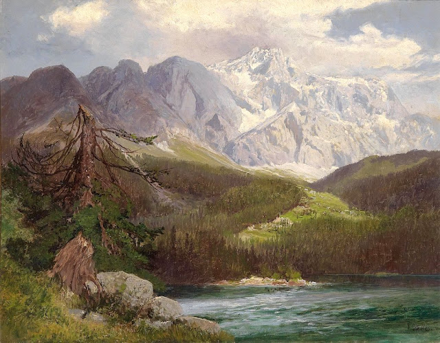
TOFANE PAINTED BY ELIJAH WALTON


https://wanderingvertexes.blogspot.com/2021/03/tofane-painted-by-elijah-walton.html
 
ELIJAH WALTON (1832-1880)
Tofane (3,244 m  - 10,643 ft) 
Italy 

In Tofane as seen from near Cortina d'Ampezzo, Tyrol. 1866 , Birmingham Museum and Art Gallery


The mountain

 Tofane is a mountain group in the Dolomites of northern Italy, west of Cortina d'Ampezzo in the province of Belluno, Veneto. Most of the Tofane lies within Parco naturale delle Dolomiti d'Ampezzo, a nature park. The highest peaks of the Tofane group are Tofana di Mezzo (3,244 m -10,643 ft), Tofana di Dentro (3,238 m-10,623 ft), and Tofana di Rozes (3,225 m -10,581 ft). Tofana di Mezzo is the third highest peak in the Dolomites, after Marmolada (3,343 m -10,968 ft)) and Antelao (3,262 m -10,702 ft). All three peaks were first climbed by Paul Grohmann along with local mountain guides, in 1863 (Tofana di Mezzo - with Francesco Lacedelli), 1864 (Tofana di Rozes - with Francesco Lacedelli, Angelo Dimai and Santo Siorpaes) and 1865 (Tofana di Dentro - with Angelo Dimai).During the First World War, the Tofane was a battlefield of the Italian Front for clashes between the Italian and Austro-Hungarian forces. The front lines went through the mountains.At the 1956 Winter Olympics, Mount Tofane hosted five of the six alpine skiing events. It regularly hosts women's speed events on the World Cup circuit, and is scheduled to host the World Championships in 2021. The route is famous for the Tofana Schuss, where the athletes can reach 130 kilometers per hour.


The artist
The British landscapist, Elijah Walton is best known for his landscapes of mountains in the Alps.
Due to the poorness of his family, without the help of one or two friends he would have been unable to study art, for which his talent was soon exhibited. After passing some years at the art academy in Birmingham, he became at the age of eighteen a student at the Royal Academy Schools in London, where he had already exhibited a picture. There he worked assiduously, drawing from the antique and from life. Nearly ten years later an accidental circumstance revealed to a friend his capabilities in mountain landscape, and in 1860, immediately after his marriage, he went to Switzerland. Thence he proceeded to Egypt, where unhappily his wife died of dysentery near the second cataract. He remained in the east, spending some time in Syria and at Constantinople, till the spring of 1862, when he returned for a short time to London. But for the next five years he was much abroad, working either in the Alps or in Egypt. His sketching tours then became rarer and shorter, though he visited Greece, Norway, and the Alps. At first he resided at Staines, then removed to the neighbourhood of Bromsgrove, living most of the time at the Forelands, near that town. In 1872 his wife died, and the loss permanently affected his health. He died on 25 August 1880 at his residence Beacon Farm, Lickey near Bromsgrove in Worcestershire, leaving three sons. Walton's life was bound up in his art. He worked both in oils and in watercolours, but was more successful with the latter. Most thorough and conscientious in the study both of form and of colour, he delighted especially in mountain scenery and in atmospheric effects, such as an Alpine peak breaking through the mists, or a sunset on the Nile. Few men have equalled him in the truthful rendering of rock structure and mountain form. His pictures were much appreciated by lovers of nature; but as those of small size sold better than larger and more highly finished works, this fostered a tendency to mannerisms.

___________________________________________


2021 - Wandering Vertexes...
by Francis Rousseau

Wednesday, February 10, 2021

KANGCHENJUNGA PAINTED BY GAGANENDRANATH TAGORE


https://wanderingvertexes.blogspot.com/2021/02/kangchenjunga-painted-by-gaganendranath.html

GAGANENDRANATH  TAGORE  (1867-1938)
Kangchenjunga (8, 538m - 28,169 ft)
India, Népal

In Kangchenjunga, watercolor,  National Gallery of Modern Art, New Delhi


The painter
Gaganendranath Tagore was an Indian painter and cartoonist of the Bengal school. Along with his brother Abanindranath Tagore, he was counted as one of the earliest modern artists in India. Gaganendranath Tagore was born at Jorasanko into a family whose creativity defined Bengal's cultural life. Gaganendranath was the eldest son of Gunendranath Tagore, grandson of Girindranath Tagore and a great-grandson of Prince Dwarkanath Tagore. His brother Abanindranath was a pioneer and leading exponent of the Bengal School of Art. He was a nephew of the poet Rabindranath Tagore and the paternal great-grandfather of actress Sharmila Tagore. Gaganendranath received no formal education but trained under the watercolourist Harinarayan Bandopadhyay. In 1907, along with his brother Abanindranath, he founded the Indian Society of Oriental Art which later published the influential journal Rupam. Between 1906 and 1910, the artist studied and assimilated Japanese brush techniques and the influence of Far Eastern art into his own work, as demonstrated by his illustrations for Rabindranath Tagore's autobiography Jeevansmriti (1912). He went on to develop his own approach in his Chaitanya and Pilgrim series. Gaganendranath eventually abandoned the revivalism of the Bengal School and took up caricature. The Modern Review published many of his cartoons in 1917. From 1917 onwards, his satirical lithographs appeared in a series of books, including Play of Opposites, Realm of the Absurd and Reform Screams.
Between 1920 and 1925, Gaganendranath pioneered experiments in modernist painting.  Partha Mitter describes him as "the only Indian painter before the 1940s who made use of the language and syntax of Cubism in his painting". From 1925 onwards, the artist developed a complex post-cubist style.

The mountain
Kangchenjunga (8,586 m - 28,169 ft) is the third highest mountain in the world. It lies partly in Nepal and partly in Sikkim, India. Kangchenjunga is the second highest mountain of the Himalayas after Mount Everest. Three of the five peaks – Main, Central and South – are on the border between North Sikkim and Nepal. Two peaks are in the Taplejung District, Nepal.
Kangchenjunga Main is the highest mountain in India, and the easternmost of the mountains higher than 8,000 m (26,000 ft).
Until 1852, Kangchenjunga was assumed to be the highest mountain in the world, but calculations based on various readings and measurements made by the Great Trigonometrical Survey of India in 1849 came to the conclusion that Mount Everest., known as Peak XV at the time, was the highest.
It is listed int the Eight Thousanders and as Seven Third Summits
Kangchenjunga is the official spelling adopted by Douglas Freshfield, A. M. Kellas, and the Royal Geographical Society that gives the best indication of the Tibetan pronunciation. Freshfield referred to the spelling used by the Indian Government since the late 19th century. There are a number of alternative spellings including Kangchendzцnga, Khangchendzonga, and Kanchenjunga.
Local Lhopo people believe that the treasures are hidden but reveal to the devout when the world is in peril; the treasures comprise salt, gold, turquoise and precious stones, sacred scriptures, invincible armor or ammunition, grain and medicine. Kangchenjunga's name in the Limbu language is Senjelungma or Seseylungma, and is believed to be an abode of the omnipotent goddess Yuma Sammang.
It rises in a section of the Himalayas called Kangchenjunga Himal that is limited in the west by the Tamur River, in the north by the Lhonak Chu and Jongsang La, and in the east by the Teesta River. It lies about 128 km (80 mi) east of Mount Everest.
Allowing for further verification of all calculations, it was officially announced in 1856 that
Kangchenjunga was first climbed on 25 May 1955 by Joe Brown and George Band, who were part of a British expedition. They stopped short of the summit as per the promise given to the Chogyal that the top of the mountain would remain inviolate. Every climber or climbing group that has reached the summit has followed this tradition...

____________________________

2021 - Wandering Vertexes...
by Francis Rousseau
Sunday, January 31, 2021

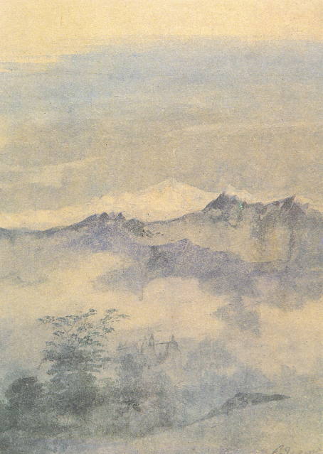
THE DENTELLES DE MONTMIRAIL PAINTED BY A. G. CARRICK / H.M KING CHARLES III


https://wanderingvertexes.blogspot.com


A. G. CARRICK / H.M KING CHARLES III former PRINCE OF WALES (bn.1948)
Les Dentelles de Montmirail (734m - 2,400 ft)
France (Vaucluse)

In Les Dentelles de Montmirail from Le Barroux, watercolor, Priaate coillection


The mountains
The Dentelles de Montmirail (734 m - are a small chain of mountains in Provence in France, in the département of Vaucluse, located just to the south of the village of Vaison-la-Romaine. They are foothills of the highest peak in Provence, Mont Ventoux, which is situated just to the east. The dramatically jagged shape of their peaks was formed by horizontal strata of Jurassic limestone being folded and forced into a nearly upright position and subsequently eroded into sharp-edged ridges and spikes. The highest peak of the Dentelles is St-Amand, at 734 m (2,400 ft). The range, which is about 8 km wide, offers over 600 trails for walking, rock climbing, and mountain biking.]The foot of the Dentelles is surrounded by vineyards of the Rhône Valley. Their name Dentelles, the French word for "lace," refers to their shape obtained by erosion, while Montmirail is derived from the Latin mons mirabilis meaning 'admirable mountain'.
Located on the territory of the communes of Beaumes-de-Venise, Crestet, Gigondas, La Roque-Alric, Lafare, Le Barroux, Malaucène, Suzette, and Vacqueyras; the Dentelles de Montmirail were an important natural frontier during Antiquity between the tribes of the Memini in the south, and the Voconces in the north. 

The painter
Arthur George Carrick is actually H.M. the King Charles III, former Prince of Wales.
When he began showing his paintings, he was too nervous to display his name so displayed under a pseudonym. Arthur George are two of his names (Charles Phillip Arthur George) and one of his titles is Earl of Carrick. King Charles III is an experienced watercolourist.  He has been painting for most of his adult life, during holidays or when his official diary allows. King Charles' interest began during the 1970s and 1980s when he was inspired by Robert Waddell, who had been his art master at Gordonstoun in Scotland. In time, King Charles met leading artists such as Edward Seago, with whom he discussed watercolour technique, and received further tuition from John Ward, Bryan Organ and Derek Hill.
The Royal Family has a tradition of drawing and painting, and King Charles’ work first came to public notice at a 1977 exhibition at Windsor Castle at which other Royal artists included Queen Victoria, The Duke of Edinburgh and The Duke of York.
King Charles paints in the open air, often finishing a picture in one go and his favourite locations include The Queen's estate at Balmoral in Scotland and Sandringham House in Norfolk, England. Sometimes King Charles  III paints during his skiing holidays, and during overseas tours when possible.
The copyright of King Charles' watercolours belongs to A. G. Carrick Ltd, a trading arm of The King's Charities Foundation. Over the years King Charles III has agreed to exhibitions of his watercolours and of lithographs made from them, on the understanding that any income they generate goes to The Prince of Wales's Charitable Foundation.
Money from the sale of the lithographs also goes to the Foundation but the paintings themselves are never for sale.
In the 1980s King Charles III, then Prince of Wales,  began inviting young British artists to accompany him on official tours overseas and record their impressions, a tradition that has continued to this day.
Reference :
- The prince of Wales paintings 

______________________________

2021 - Wandering Vertexes...
by Francis Rousseau


Saturday, January 23, 2021

DEDO DE DEUS PAINTED BY ELISEU VISCONTI

https://wanderingvertexes.blogspot.com/2021/01/dedo-de-deus-painted-by-eliseu-visconti.html

ELISEU VISCONTI (1866-1944)
Dedo de Deus (1,682m - 5,551ft)
Brazil

The mountain
Dedo de Deus (The Finger of God) (1,682m - 5,551ft) is a peck whose outline resembles a hand pointing the index finger to the sky. It is one of the several geological monuments of Serra dos Órgãos which is located in Serra do Mar, between the cities of Petrópolis, Guapimirim and Teresópolis, in the state of Rio de Janeiro, in Brazil. The mountaineering in Brazil is closely linked to the achievement of the Dedo de deus. The peak is a state symbol Rio de Janeiro, appearing on its flag and coat of arms. As for the coat of arms of the State of Rio de Janeiro, the first section, occupying the upper half, is blue, representing the sky and symbolizing justice, truth and loyalty, with the silhouette of the Serra dos Órgãos, highlighting the Dedo de Deus.  The symbol was created by the 1892 State Constitution and made official under the government of José Tomás da Porciúncula, with small differences over time.  In 1912, José Guimarães Teixeira, Raul Carneiro and the brothers Américo, Alexandre and Acácio de Oliveira, all from Teresópolis, were the first to step on top of the rock formation.


The artist
Eliseu Visconti, born Eliseo d'Angelo Visconti was an Italian-born Brazilian painter, cartoonist, and teacher. He is considered one of the very few impressionist painters of Brazil. He is considered the initiator of the art nouveau in Brazil.
Thanks to a prize received in 1892, Visconti travelled to Paris, where he attended the École des Beaux Arts the following year. He also took classes at the Académie Julian and the École nationale supérieure des arts décoratifs, where he was a pupil of art nouveau master Eugène Grasset. He was accepted at the Salon de la Nationale des Beaux Arts and at the Salon of the Société of des Artistes Français. As one of the Brazilian representatives to the Exposition Universelle 1900 he exhibited the paintings Gioventú and Oréadas, for which he received a silver medal. Back in Brazil, Visconti exhibited in Rio de Janeiro and São Paulo, and obtained the first place in a contest for the drawing of postal stamps for the Brazilian Casa da Moeda.  He traveled again to Europe, where he exhibited at the Paris Salon of 1905 the portrait of the artist Nicolina Vaz de Assis now at the Museu Nacional de Belas Artes. In this same year, he was invited to paint the stage curtain for the Teatro Municipal of Rio de Janeiro which he completed in his studio in Paris.
Decorative schemes executed for the National Library or Biblioteca Nacional in (Rio de Janeiro) date from this period as does another gold medal he received at the International Exhibition of Saint-Louis (Louisiana Purchase Exposition), in 1904, for the painting Recompensa de São Sebastião (see external links). The museum of Santiago of the Chile acquired his Sonho Místico (Mystical Dream) in 1912.  In 1913, Visconti returned to Europe in order to paint large scale panels for the "foyer" of the Theatro Municipal do Rio de Janeiro. His plans to return were interrupted by the First World War so he stayed in France until 1920. The resulting paintings for the "foyer" were sent to Brazil during the war, in 1915.  In 1922 his triptych "Lar" gained him the Medal of Honor in a large exhibition created in Rio de Janeiro to commemorate the first centennial of Brazilian Independence, the Exposição do Centenário.  The following year Visconti painted the mural decoration of Rio de Janeiro's municipal council hall. In 1924, he painted the panel depicting the signature of the first Republican Constitution, for the old federal court, also in Rio de Janeiro.


_______________________________

2021 - Wandering Vertexes...
by Francis Rousseau


Saturday, December 12, 2020

LA DENT DU GÉANT PAINTED BY MARCEL WIBAULT


https://wanderingvertexes.blogspot.com/2020/12/la-dent-du-geant-painted-by-marcel.html


MARCEL WIBAULT (1904-1998)
La dent du Géant (4,013 m -13,166 ft)
France - Italy


The mountain
The Dent du Géant (4,013 m -13,166 ft) (« Giant's tooth") is a mountain in the Mont Blanc massif in France and Italy. The Dent du Géant remained unclimbed during the golden age of alpinism, and was a much-coveted peak in the 1870s, repelling many parties who attempted it mostly from the Rochefort ridge. In 1880 the strong team of Albert F. Mummery and Alexander Burgener tried to force a passage via the south-west face but were repelled by a band of slabs, causing Mummery to exclaim 'Absolutely inaccessible by fair means!'
The mountain has two summits, (27m-88 ft) apart and separated by a small col :
- Pointe Sella (4,009 m), first ascent via the south-west face by Jean Joseph Maquignaz with son Baptiste Maquignaz and nephew, Daniel Maquignaz on 28 July 1882.
- Pointe Graham (4,013 m), first ascent by W. W. Graham with guides Auguste Cupelin and Alphonse Payot on 20 August 1882.


The artist
Marcel Wibault is a french painter known especially for his numerous paintings of mountains representing Mont-Blanc, Chamonix, the great peaks of the Alps and their "chalets". He made his débuts in art by ketching soldiers of the 60th Infantry Regiment of Besançon. Later he discovered, as a Member of the French Alpine Club, the Alps and its grandiose landscapes. At the start of the 1930s, he settled in Chamonix-Mont-Blanc and discovered, in these troubled times, the departments of Savoie and Haute-Savoie. Encouraged by his wife, Marcel Wibault painted the mountain and its surroundings. Living in Chamonix, he travels the surroundings with his painting equipment. He could produce works in one sitting. Commissioned by the Museum of Natural History and the city of Geneva in Switzerland, as a true knowledgeable geologist, he painted numerous rocks. In the 1960s, he also testified, through his painting, of the construction of the Mont-Blanc Tunnel. Marcel Wibault received many commissions from art lovers and was able to live in part from his art. He was also a teacher for his son Lionel Wibault who, too, is a painter. In his Chamonix chalet, Alpenrose, he made some of his furniture and sculpted many characters. 


Saturday, November 21, 2020

MOUNT SAINTE VICTOIRE BY PAUL CEZANNE


https://wanderingvertexes.blogspot.com/2020/11/mount-sainte-victoire-by-paul-cezanne.html

PAUL CÉZANNE (1839-1906)
Montagne Sainte-Victoire (1, 011m - 2, 216 ft)
France (Provences-Alpes-Côte d'Azur)

In Le Mont Sainte-Victoire, c. 1897. watercolor  on paper, Prvate collection


The mountain
Mont Sainte-Victoire (1,011 m-3,316ft) also called Mont Venturi is a limestone massif in the South of France, in the region Provence-Alpes-Côte d'Azur. Located east of Aix-en-Provence, it has experienced international fame, due to the more than 80 works Paul Cézanne did on it. It hosts many hikers, climbers and nature lovers, and is a major element of Aix landscape.
The range of the Sainte-Victoire is located on the Bouches-du-Rhône and Var, and in the towns of Puyloubier, Saint-Antonin-sur-Bayon, Rousset, Châteauneuf-le-Rouge, Beaurecueil, Le Tholonet Vauvenargues, Saint-Marc-Jaumegarde, Pourrières, Artigues and Rians. On the northern side, the D10 crosses the Col de Claps (530 m) and the Col des Portes (631 m). On the southern side, the D 17 walks on the Plateau de Cengle and crossed the Collet blanc de Subéroque (505 m).
The massif rises to the Pic des Mouches (Peak of the Flies) (1,011 m) near the eastern end of the chain, and not at the Croix de Provence (946 m) near the west end and visible from Aix. The Pic des Mouches is one of the highest peaks of the department of Bouches-du-Rhône, behind the peak Bertagne which reached an altitude of 1,042 mètres and which is located on the massif of Sainte-Baume.
Sainte-Victoire, as the range of the Sainte Baume, can be considered a special case among the Alpine ranges for the various stages of the formation of its relief associated geological history as well as that of the old Pyrenean-Provençal chain than that of the Western Alps (which have succeeded it).
Indeed, from the former Sainte-Victoire mountain, contemporary of the dinosaurs of the Cretaceous, appeared 15 million years BCE.
Sainte-Victoire, whose calcareous sediments date back to the Jurassic, thus consists of both a Pyrenean-Provencal vestige and of an alpine geology.
The massif is a ensemble of 6525 ha classified since 1983.
The massive hosts several world-famous dinosaur eggs deposits including the Roques-Hautes / Les Grands-Creux on the town Beaurecueil.

The painter
The mount Sainte-Victoire appears to have been the subject of a true love story with the painter (Paul Cézanne). He painted this subject more than 80 times, in oil paintings, watercolors and drawings !
Aix-en Provence (France) painter Paul Cezanne still remains closely linked to his hometown. His studio in Les Lauves remains a place to visit, as if the painter was coming back from one second to the other. But the eternal bond is undoubtedly the series of paintings he did of the Montagne Sainte-Victoire. A hobby, a passion, a thread in the painter's work that took place in the latter part of his life, between 1882 and 1906 when he died in Aix. History says that the painter had contracted a nasty pneumonia during a working session on the mountain. This is what can be called 'die on stage'.
Cézanne had a considerable influence on the art of the late nineteenth and the early twentieth century. Acknowledged master of his time, he attended during stays in Paris between 1862 and 1882, the Impressionist band: Camille Pissarro, Auguste Renoir (who also ended his life in the Provencal brightness), Claude Monet, Alfred Sisley and others. He participated in the Impressionist adventure while keeping his personality: it is the time of the shock of the en plein air, easels in the grass, looking for natural light and emotion.
The influence of the Aix painter is recognized in the history of art since it would be the cause of the Cubist movement embodied in 1906 by Pablo Picasso and Georges Braque. The first historically so called Cubist painting ' Les Demoiselles d'Avignon' would, a true artistic shock shown by Picasso in 1907 (one year after the death of Cézanne) is today one of the masterpieces of the MoMA in New York.
It is the search of volumes around which leads to the appearance of geometry in landscapes or still lifes of Cézanne.In 20 years, Cézanne pushes his style to express the emotion of the landscape, suggesting the wind, involving movement just like if we can breathe the air of the scene. In his first paintings pf the Sainte Victoire,(in the 1880’s) he expresses the giant aspect of the mountain that dominates the area with his characteristic e way of painting at the time, with a juxtaposition of linear brushstrokes and a range of soft, natural colors. IN the last paintings of the Sainte Victoire, view from Les Lauves, between 1904 and 1906, he shows shots less accurate brushes allowing the shape of the mountain emerge from the canvas like an apparition. That is the whole intention of the artist, show nature as it is without fail to convey emotion.
A true love story…
________________________________
2020 - Wandering Vertexes...
by Francis Rousseau

Tuesday, September 15, 2020

THE RIGI PAINTED BY TURNER


J.M.W. TURNER (1775-1851)
The Rigi or Rigi Kulm or Mount Rigi (1, 797m - 5,897ft)
Switzerland

In Lucerne by Moonlight - Sample Study, ca.1842/43, Watercolour on paper, 23.5 x 32.5 cm,
Tate London

The mountain
The Rigi (1, 797m - 5,897ft) is a mountain massif of the Alps, located in Central Switzerland.
The whole massif is almost entirely surrounded by the water of three different water bodies: Lake Lucerne, Lake Zug and Lake Lauerz. The range is in the Schwyzer Alps, and is split between the cantons of Schwyz and Lucerne, although the main summit, named Rigi Kulm, at 1,798 meters above sea level, lies within the canton of Schwyz. Technically, the Rigi is not a part of the Alps, and belongs instead to the Swiss plateau. It is mostly composed of molasse and other conglomerate, as opposed to the Bündner schist and flysch of the Alps.
The Rigi Kulm and other areas, such as the resort of Rigi Kaltbad, are served by Europe's oldest mountain railways, the Rigi Railways. Swiss Railways offer a special round-trip excursion, the “Rigi-Rundfahrt”, covering multiple segments by train, cog-railway, gondola (optional) and lake steamer. The whole area offers many activities such as skiing or sledging in the winter, and hiking in the summer.
The name Rigi is from Old High German "rîga" which means "row, stripe, furrow", after the stratification that is clearly visible on the north-side of the mountain. The name is first recorded in 1350 as Riginun. The name was interpreted as Regina montium "queen of mountains" by Albrecht von Bonstetten (1479), who however gives Rigena as alternative form.
Mt. Rigi has been featured in many works of art, including both paintings and literary publications. Perhaps the most famous paintings of the Rigi were the series by J.M.W. Turner , several of which are in the collection of the Tate Britain in London.
Mark Twain also visited Rigi during his tour of Central Europe in the late 1870s, and wrote about his travels in chapter 28 of his "A Tramp Abroad."

The painter
The english painter Joseph Mallord William Turner was considered a controversial figure in his day, but is now regarded as the artist who elevated landscape painting to an eminence in the history of painting. Although renowned for his oil paintings, Turner is also one of the greatest masters of British watercolour landscape painting. He is commonly known as "the painter of light" and his work is regarded as a Romantic preface to Impressionism.
More about Turner

_______________________________
2020 - Wandering Vertexes...
by Francis Rousseau

Tuesday, September 8, 2020

THE DACHSTEIN PAINTED BY FERDINAND GEORG WALDMÜLLER


FERDINAND GEORG WALDMÜLLER (1793-1865)
Hoher Dachstein (2, 995m - 9, 826ft)
 Austria 
In The Dachstein, 1835, oil on canvas, Belvedere Museum, Vienna

The mountain
Hoher Dachstein (2, 995m - 9, 826ft) is a strongly karstic Austrian mountain, and the second highest mountain in the Northern Limestone Alps. It is situated at the border of Upper Austria and Styria in central Austria, and is the highest point in each of those states. Parts of the massif also lie in the state of Salzburg, leading to the mountain being referred to as the Drei-Lander-Berg ("three-state mountain"). The Dachstein massif covers an area of around 20x30 km with dozens of peaks above 2,500 m, the highest of which are in the southern and south-western areas. Seen from the north, the Dachstein massif is dominated by the glaciers with the rocky summits rising beyond them. By contrast, to the south, the mountain drops almost vertically to the valley floor.
The summit was first reached in 1832 by Peter Gappmayr, via the Gosau glacier, after an earlier attempt by Erzherzog Karl via the Hallstätter glacier had failed. Within two years of Gappmayr's success a wooden cross had been erected at the summit. The first person to reach the summit in winter was Friedrich Simony, on 14 January 1847. The sheer southern face was first climbed on 22 September 1909 by the brothers Irg and Franz Steiner.
Being the highest point of two different Bundesländer, the summit is a popular goal in both summer and winter. In fine weather as many as 100 climbers may be attempting the ascent, leading to congestion at key sections of the climb.

The painter
Ferdinand Georg Waldmüller was an Austrian writer and one of the most important painters of the Biedermeier period. Whether it was the conquest of the landscape and thus the convincing rendering of closeness or distance, the accurate characterisation of the human face, the detailed and refined description of textures, or the depiction of rural everyday life: his works – brilliant, explanatory, moralising, and socially critical – influenced a whole generation of artists. Being an advocate of natural observation and plein air painting, as well as a critic of academic painting, Waldmüller was far ahead of his time.

____________________________________

Wandering Vertexes 2020
A blog by Francis Rousseau


Thursday, August 20, 2020

THE MOUNT SAINTE-VICTOIRE PAINTED BY PAUL CÉZANNE


 PAUL CÉZANNE (1839-1906)
Montagne Sainte Victoire (1, 011m - 2, 216 ft)
France (Provence Alpes Côte d'azur) 
 In Plaine près de la Montagne Sainte-Victoire, c. 1882-85   oil on canvas, 58 x 72 cm. Musée Pushkin, Moscou
The mountain
Mont Sainte-Victoire (1,011 m-3,316ft) also called Mont Venturi is a limestone massif in the South of France, in the region Provence-Alpes-Côte d'Azur. Located east of Aix-en-Provence, it has experienced international fame, due to the more than 80 works Paul Cézanne did on it.
It hosts many hikers, climbers and nature lovers, and is a major element of Aix landscape.
The range of the Sainte-Victoire is 18 kilometers long and 5 kilometers from large, following a strict east-west orientation. It is located on the Bouches-du-Rhône and Var, and in the towns of Puyloubier, Saint-Antonin-sur-Bayon, Rousset, Châteauneuf-le-Rouge, Beaurecueil, Le Tholonet Vauvenargues, Saint-Marc-Jaumegarde, Pourrières, Artigues and Rians.
The Sainte-Victoire, as the range of the Sainte Baume, can be considered a special case among the Alpine ranges for the various stages of the formation of its relief associated geological history as well as that of the old Pyrenean-Provençal chain than that of the Western Alps (which have succeeded it).
Indeed, from the former Sainte-Victoire mountain, contemporary of the dinosaurs of the Cretaceous, it remains today only the fold Bimont, said Chaînon des Costes Chaudes, the last vestige resulting from tectonic movements and characteristics of the stacks of Pyreneo-Provençal phase during the Eocene. Later during the Oligocene, breaking of the anticlinal fold of Sainte-Victoire, which resulted from the uplift of the first great Alpine reliefs, is causing a surge that help explain the current form of the mountain, which appeared 15 million years BCE.
According to a recent study, the Sainte-Victoire is still growing ! The company ME2i has indeed conducted a satellite survey between 1993 and 2003 providing evidence that during this period the western end of the Sainte-Victoire was uplift of 7 mm per year.
The massif is a ensemble of 6525 ha classified since 1983.

The painter
The mount Sainte-Victoire appears to have been the subject of a true love story with the painter Paul Cezanne. He painted this subject more than 80 times, in oil paintings, watercolors and drawings!
Aix-en Provence (France) painter Paul Cezanne still remains closely linked to his hometown. His studio in Les Lauves remains a place to visit, as if the painter was coming back from one second to the other. But the eternal bond is undoubtedly the series of paintings he did of the Montagne Sainte-Victoire. A hobby, a passion, a thread in the painter's work that took place in the latter part of his life, between 1882 and 1906 when he died in Aix. History says that the painter had contracted a nasty pneumonia during a working session on the mountain. This is what can be called 'die on stage'.
Cézanne had a considerable influence on the art of the late nineteenth and the early twentieth century. Acknowledged master of his time, he attended during stays in Paris between 1862 and 1882, the Impressionist band: Camille Pissarro, Auguste Renoir (who also ended his life in the Provencal brightness), Claude Monet, Alfred Sisley and others. He participated in the Impressionist adventure while keeping his personality: it is the time of the shock of the en plein air, easels in the grass, looking for natural light and emotion.
The influence of the Aix painter is recognized in the history of art since it would be the cause of the Cubist movement embodied in 1906 by Pablo Picasso and Georges Braque. The first historically so called Cubist painting ' Les Demoiselles d'Avignon' would, a true artistic shock shown by Picasso in 1907 (one year after the death of Cézanne) is today one of the masterpieces of the MoMA in New York.
It is the search of volumes around which leads to the appearance of geometry in landscapes or still lifes of Cézanne.In 20 years, Cézanne pushes his style to express the emotion of the landscape, suggesting the wind, involving movement just like if we can breathe the air of the scene. In his first paintings pf the Sainte Victoire,(in the 1880’s) he expresses the giant aspect of the mountain that dominates the area with his characteristic e way of painting at the time, with a juxtaposition of linear brushstrokes and a range of soft, natural colors. In the last paintings of the Sainte Victoire, view from Les Lauves, between 1904 and 1906, he shows shots less accurate brushes allowing the shape of the mountain emerge from the canvas like an apparition. That is the whole intention of the artist, show nature as it is without fail to convey emotion.

_______________________________
2020 - Wandering Vertexes...
by Francis Rousseau


Tuesday, August 4, 2020

THE BREITHORN PAINTED BY JOHN J. REDMOND


JOHN J. REDMOND (1856-1929)
The Breithorn (4,165 m -13,664 ft) 
Switzerland - Italy border

In  Sunset on the Breithorn from Mürren, Bernese Oberland, Switzerland, oil on canvas, 
Courtesy John Mitchell Gallery, London 

The mountain
The Breithorn (4,165 m -13,664 ft) which means "broad horn" in german - is a mountain range of the Pennine Alps as well as its highest peak (also called Breithorn Western Summit). The Breithorn is located on the border between Switzerland and Italy. It lies on the main chain of the Alps, approximately halfway between the Matterhorn and Monte Rosa and east of the Theodul Pass. Most of the massif is glaciated and includes several subsidiary peaks, all located east of the main summit: the Western summit (4, 165m), the Middle summit (4,159m), the Eastern Breithorn-twin also called The Gendarm (4,106m), the Roccia Nera (Schwarzfluh) (4,075m). The main summit is sometimes distinguished by the name Western Breithorn (German: Breithorn (Westgipfel), Italian: Breithorn Occidentale). The nearest settlements are Zermatt (Valais) and St-Jacques (Aosta Valley).
The Breithorn was first climbed in 1813 by Henry Maynard (climber), Joseph-Marie Couttet, Jean Gras, Jean-Baptiste Erin and Jean-Jacques Erin.

The painter
John J. Redmond, was an american painter, active in late XIX and early XXth c. He belongs to the american impresssionism. His works were regularly exhibited in USA especially in Boston between 1888and 1909.
Born in Salem (Mass) he died in Switzerland.

Tuesday, June 16, 2020

THE MONT BLANC BY J.M.W. TURNER


J.M.W. TURNER (1775-1851)
Mont Blanc (4,808.13 m - 15,776.7 ft)
  France - Italy  border

 In  Bonneville, Savoy, with Mont Blanc, 1803, Oil on Canvas,  92 x 123.2 cm, 
The Dallas Museum of Art (Gift of Nancy Hamon) 


The mountain 
Mont Blanc (in French) or Monte Bianco (in Italian), both meaning "White Mountain", is the highest mountain in the Alps and the highest in Europe after the Caucasus peaks. It rises 4,808.73 m (15,777 ft) above sea level and is ranked 11th in the world in topographic prominence.  The Mont Blanc is one of the Seven Summit, which includes the highest mountains of each of the seven continents. Summiting all of them is regarded as a mountaineering challenge, first achieved on April 30, 1985 by Richard Bass.  The 7 highest summit, (which are obviously 8 with 2 in Europe !) are :  
Mount Everest (8,848m), Aconcagua (6,961m), Mt Denali or Mc Kinley (6,194m),  Kilimandjaro (5,895m), Mt Elbrus (5,642m), Mount Vinson (4,892m) and Mount Kosciuszko  (2,228m) in Australia.
The mountain lies in a range called the Graian Alps, between the regions of Aosta Valley, Italy, and Savoie and Haute-Savoie, France. The location of the summit is on the watershed line between the valleys of Ferret and Veny in Italy and the valleys of Montjoie, and Arve in France. The Mont Blanc massif is popular for mountaineering, hiking, skiing, and snowboarding.
Moreabout Mont Blanc

The painter 
The english painter Joseph Mallord William Turner was considered a controversial figure in his day, but is now regarded as the artist who elevated landscape painting to an eminence in the history of painting. Although renowned for his oil paintings, Turner is also one of the greatest masters of British watercolour landscape painting. He is commonly known as "the painter of light" and his work is regarded as a Romantic preface to Impressionism.
More about Turner 

___________________________________

2020 - Wandering Vertexes...
by Francis Rousseau

Wednesday, June 3, 2020

THE LANGDALE PIKES BY WILLIAM T. LONGMIRE


WILLIAM TAYLOR LONGMIRE (1841-1914)
The Langdale Pikes (739 m - 2,424 ft)
United Kingdom ( England)

The mountains
The Langdale Pikes range (739 m - 2,424 ft) rises along the northern slope of the Great Langdale Valley (Cumbria, England). The Langdale Pikes are (from west to east) the Pike of Stickle, the Loft Crag, the Harrison Stickle and Pavey Ark. From the valley, it take on the appearance of a steep rocky ridge, but only the southern slope actually has steep peaks; on the north slope, the slopes gently incline towards High Raise, twin summit of this range. Harrison Stickle (739 m - 2,424 ft) is the highest point of the Langdale Pikes; Pike of Stickle is 700 m - 2,296 ft high ; Loft Crag (682m-2,237ft )is located halfway between Harrison Stickle and Pike o ’Stickle ; The last peak iof the range is Pavey Ark (700 m - 2,296 ft ).

The painter
William T. Longmire was expected to follow in his father’s steps and become a farmer but, encouraged to paint by the local vicar, he had set himself up in a studio in Ambleside by the age of thirty, following in the footsteps of William Green and Harriet Martineau. Unlike Martineau and Green, Longmire was born and grew up in Westmorland, making him a pioneer in looking beyond a life as a farmer, instead taking advantage of the continued growth in tourism. He is well known for his numerous watercolours of english landscape in which he frequently depicted sheeps!

___________________________________________
2020 - Wandering Vertexes...
by Francis Rousseau