google.com, pub-0288379932320714, DIRECT, f08c47fec0942fa0 GRAVIR LES MONTAGNES... EN PEINTURE

Thursday, February 16, 2017

EL CHIMBORAZO MAPPED BY ALEXANDER VON HUMBOLDT


ALEXANDER VON HUMBOLDT  (1769-1859) 
Chimborazo  (6,263 m - 20,549  ft)
Ecuador
(Click images to enlarge)

In Map of the Mountain Chimborazo in 1802


The mountain
Chimborazo  (6,263 m -20,548 ft) is a currently inactive stratovolcano in the Cordillera Occidental range of the Andes ans the highest mountain in Ecuador and the Andes north of Peru ; it is higher than any more northerly summit in the Americas. Chimborazo is not the highest mountain by elevation above sea level, but its location along the equatorial bulge makes its summit the farthest point on the Earth's surface from the Earth's center.
Chimborazo is at the main end of the Ecuadorian Volcanic Arc, north west of the town of Riobamba. Chimborazo is in la Avenida de los Volcanes (the Avenue of Volcanoes) west of the Sanancajas mountain chain. Carihuairazo, Tungurahua, Tulabug, and El Altar are all mountains that neighbor Chimborazo.  The closest mountain peak, Carihuairazo, is 5.8 mi (9.3 km) from Chimborazo. There are many microclimates near Chimborazo, varying from desert in the Arenal to the humid mountains in the Abraspungo valley.
Its last known eruption is believed to have occurred around A.D. 550. 
Until the beginning of the 19th century, it was thought that Chimborazo was the highest mountain on Earth (measured from sea level), and such reputation led to many attempts on its summit during the 17th and 18th centuries.
In 1746, the volcano was explored by French academicians from the  French Geodesic Mission. Their mission was to determine the sphericity of the Earth. Their work along with another team in Lapland established that the Earth was an oblate spheroid rather than a true sphere. They did not reach the summit of Chimborazo.
In 1802, during his expedition to South America, Baron Alexander von Humboldt, accompanied by Aimé Bonpland and the Ecuadorian Carlos Montufar, tried to reach the summit. From his description of the mountain, it seems that before he and his companions had to return suffering from altitude sickness they reached a point at 5,875 m, higher than previously attained by any European in recorded history. (Incans had reached much higher altitudes previously). In 1831, Jean-Baptiste Boussingault and Colonel Hall reached a new "highest point", estimated to be 6,006 m.
On 4 January 1880, the English climber Edward Whymper reached the summit of Chimborazo. The route that Whymper took up Chimborazo is now known as the Whymper route. Edward Whymper, and his Italian guides Louis Carrel and Jean-Antoine Carrel, were the first Europeans to summit a mountain higher than 20,000 feet. As there were many critics who doubted that Whymper had reached the summit, later in the same year he climbed to the summit again, choosing a different route (Pogyos) with the Ecuadorians David Beltrбn and Francisco Campaсa.

The cartographer 
Friedrich Wilhelm Heinrich Alexander von Humboldt was a Prussian geographer, naturalist, explorer, and influential proponent of Romantic philosophy and science. He was the younger brother of the Prussian minister, philosopher, and linguist Wilhelm von Humboldt (1767–1835). Humboldt's quantitative work on botanical geography laid the foundation for the field of biogeography. Humboldt's advocacy of long-term systematic geophysical measurement laid the foundation for modern geomagnetic and meteorological monitoring.
Between 1799 and 1804, Humboldt travelled extensively in Latin America, exploring and describing it for the first time from a modern scientific point of view. His description of the journey was written up and published in an enormous set of volumes over 21 years. Humboldt was one of the first people to propose that the lands bordering the Atlantic Ocean were once joined (South America and Africa in particular). Humboldt resurrected the use of the word cosmos from the ancient Greek and assigned it to his multi-volume treatise, Kosmos, in which he sought to unify diverse branches of scientific knowledge and culture. This important work also motivated a holistic perception of the universe as one interacting entity.
On their way back to Europe from Mexico on their way to the United States, Humboldt and his fellow scientist Aimé Bonpland stopped in Cuba for a While. After their first stay in Cuba of three months they returned the mainland at Cartagena de Indias (now in Colombia), a major center of trade in northern South America. Ascending the swollen stream of the Magdalena River to Honda and arrived in Bogotá on July 6, 1801 where they met Spanish botanist José Celestino Mutis, the head of the Royal Botanical Expedition to New Granada, staying there until September 8, 1801. Mutis was generous with his time and gave Humboldt access to the huge pictorial record he had compiled since 1783.  Humboldt had hopes of connecting with the French sailing expedition of Baudin, now finally underway, so Bonpland and Humboldt hurried to Ecuador. They crossed the frozen ridges of the Cordillera Real, they reached Quito on 6 January 1802, after a tedious and difficult journey.
Their stay in Ecuador was marked by the ascent of Pichincha and their climb of Chimborazo, where Humboldt and his party reached an altitude of 19,286 feet (5,878 m). This was a world record at the time, but a thousand feet short of the summit.  Humboldt's journey concluded with an expedition to the sources of the Amazon en route for Lima, Peru.
At Callao, the main port for Peru, Humboldt observed the transit of Mercury. On 9 November and studied the fertilizing properties of guano, rich in nitrogen, the subsequent introduction of which into Europe was due mainly to his writings.

Wednesday, February 15, 2017

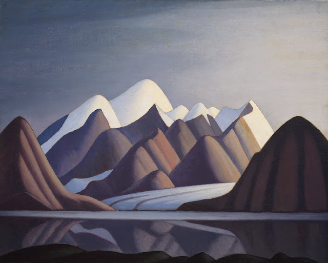
MOUNT THULE PAINTED BY LAWREN HARRIS

http://wanderingvertexes.blogspot.com

LAWREN HARRIS (1885-1970)
Mount Thule  (1,711m- 5,614 ft)
Canada - Nunavut

About Nunavut
Nunavut is the newest, largest, and northernmost territory of Canada. It was separated officially from the Northwest Territories on April 1, 1999, via the Nunavut Act and the Nunavut Land Claims Agreement Act, though the boundaries had been contemplatively drawn in 1993. The creation of Nunavut resulted in the first major change to Canada's political map since the incorporation of the province of Newfoundland and Labrador in 1949.

The mountain 
Mount Thule (1,711m- 5,614 ft) is a mountain on Bylot Island, Nunavut, Canada. It is located 38 km (24 mi) north of Pond Inlet on Baffin Island. It is associated with the Baffin Mountains which in turn form part of the Arctic Cordillera mountain system. The Baffin Mountains are ice-capped mountains in which some of the highest peaks of eastern North America.  While they could be considered a single mountain range as they are separated by bodies of water to make Baffin Island, this is not true, as they are closely related to the other mountain ranges that make the much larger Arctic Cordillera mountain range. The highest point is Mount Odin at (2,147 m -7,044 ft) while Mount Asgard (2,015 m - 6,611 ft) is perhaps the most famous. The highest point in the northern Baffin Mountains is Qiajivik Mountain at (1,963 m -6,440 ft). Mount Tule is the fourth highest point (1,711m- 5,614 ft).  Being situated north of the Arctic tree line, there are no trees in the Baffin Mountains but only rocks which are primarily deeply dissected granitic rocks. It was covered with ice until about 1500 years ago, and vast parts of it are still ice-covered.  The dominant vegetation in the Baffin Mountains is a discontinuous cover of mosses, lichens and cold-hardy vascular plants such as sedge and cottongrass.
Geologically, the Baffin Mountains form the eastern edge of the Canadian Shield, which covers much of Canada's landscape. 
One of the first mountaineering expeditions in the Baffin Mountains was in 1934 by J.M Wordie, in which two peaks called Pioneer Peak and Longstaff Tower were climbed. The Auyuittuq National Park was established in 1976. It features many of Arctic wilderness, such as fjords, glaciers and ice fields. In Inuktitut - the language of Nunavut's Aboriginal people, Inuit - Auyuittuq means "the land that never melts". Although Auyuittuq was established in 1976 as a national park reserve, it was upgraded to a full national park in 2000.
There were Inuit settlements in the Baffin Mountains before European contact. The first European contact is believed to have been by Norse explorers in the 11th century, but the first recorded sighting of Baffin Island was Martin Frobisher during his search for the Northwest Passage in 1576.

The painter 
Lawren Stewart Harris, (1885–1970) was a leading landscape canadian painter, imbuing his paintings with a spiritual dimension. An inspirer of other artists, he was a key figure in the Group of Seven and gave new vision to representations of the northern Canadian landscape. During the 1920s, Harris's works became more abstract and simplified, especially his stark landscapes of the Canadian north and Arctic.  He also stopped signing and dating his works so that people would judge his works on their own merit and not by the artist or when they were painted.
In 1924, a sketching trip with A.Y. Jackson to Jasper National Park in the Canadian Rockies marked the beginning of Harris' mountain subjects, which he continued to explore with annual sketching trips until 1929, exploring areas around Banff National Park, Yoho National Park and Mount Robson Provincial Park. In 1930, Harris went on his last extended sketching trip, travelling to the Arctic aboard the supply ship SS. Beothic for two months, during which time he completed over 50 sketches.  "We are on the fringe of the great North and its living whiteness, its loneliness and replenishment, its resignations and release, tis call and answer, its cleansing rhythms. It seems that the top of the continent is a source of spiritual flow that will ever shed clarity into the growing race of America."(Lawren S. Harris, 1926)
For Harris, art was to express spiritual values as well as to represent the visible world. North Shore, Lake Superior (1926), an image of a solitary weathered tree stump surrounded by an expanse of dramatically lit sky, effectively evokes the tension between the terrestrial and spiritual.
The resulting Arctic canvases that he developed from the oil panels marked the end of his landscape period, and from 1935 on, Harris enthusiastically embraced abstract painting. Several members of the Group of Seven later became members of the Canadian Group of Painters including Harris, A. J. Casson, Arthur Lismer, A. Y. Jackson, and Franklin Carmichael.
From 1934 to 1937, Harris lived in Hanover, New Hampshire, where he painted his first abstract works, a direction he would continue for the rest of his life. In 1938 he moved to Sante Fe, New Mexico, and helped found the Transcendental Painting Group, an organization of artists who advocated a spiritual form of abstraction.
In 1969, he was made a Companion of the Order of Canada.
Harris died in Vancouver in 1970, at the age of 84, as a well-known artist. He was buried on the grounds of the McMichael Canadian Art Collection, where his work is now held.
On November 26, 2015 his painting Mountain and Glacier was auctioned for $3.9 million at a Heffel Fine Art Auction House auction in Toronto, breaking the previous record for the sale of one of Harris's works.
In 2016 a film about Harris's life, Where the Universe Sings, was produced by TV Ontario. It was created by filmmaker Peter Raymont and directed by Nancy Lang.

_______________________________
2017 - Wandering Vertexes...
by Francis Rousseau 

Tuesday, February 14, 2017

MOUNT ST HELENS BY EMMET GOWIN


EMMET GOWIN (bn. 1941) 
Mount St. Helens or Louwala-Clough (2, 549 m - 8, 363 ft) 
United States of America (Washington State)


1. Debris flow at the northern base of Mounts Helens, 1980
2. Ash over new snow on the  South flank of Mount St Helens, 1982
3. Ashes after Mount St Helens 1980 Plinian eruption, 1982 


The mountain 
Mount St. Helens ( 2, 549m- 8,363 ft )  or Louwala-Clough (known as Lawetlat'la to the Cowlitz people, and Loowit to the Klickitat people) is an active stratovolcano located in Skamania County, Washington, in the Pacific Northwest region of the United States. It is 96 miles (154 km) south of Seattle, Washington, and 50 miles (80 km) northeast of Portland, Oregon. Mount St. Helens takes its English name from the British diplomat Lord St Helens, a friend of explorer George Vancouver who made a survey of the area in the late 18th century.The volcano is located in the Cascade Range and is part of the Cascade Volcanic Arc, a segment of the Pacific Ring of Fire that includes over 160 active volcanoes. This volcano is well known for its ash explosions and pyroclastic flows.
Mount St. Helens is most notorious for its major 1980 eruption, the deadliest and most economically destructive volcanic event in the history of the United States. The magma in St. Helens burst forth into a large-scale pyroclastic flow that flattened vegetation and buildings over 230 square miles (600 km2). More than 1.5 million metric tons of sulfur dioxide were released into the atmosphere. On the Volcanic Explosivity Index scale, the eruption was rated a five (a Plinian eruption). Fifty-seven people were killed; 250 homes, 47 bridges, 15 miles (24 km) of railways, and 185 miles (298 km) of highway were destroyed. A massive debris avalanche triggered by an earthquake measuring 5.1 on the Richter scale caused an eruption that reduced the elevation of the mountain's summit from 9,677 ft (2,950 m) to 8,363 ft (2,549 m), leaving a 1 mile (1.6 km) wide horseshoe-shaped crater. The debris avalanche was up to 0.7 cubic miles (2.9 km3) in volume. For more than nine hours, a vigorous plume of ash erupted, eventually reaching 12 to 16 miles (20 to 27 km) above sea level.  The plume moved eastward at an average speed of 60 miles per hour (100 km/h) with ash reaching Idaho by noon. Ashes from the eruption were found collecting on top of cars and roofs next morning, as far as the city of Edmonton in Alberta, Canada. The Mount St. Helens National Volcanic Monument was created to preserve the volcano and allow for its aftermath to be scientifically studied.
As with most other volcanoes in the Cascade Range, Mount St. Helens is a large eruptive cone consisting of lava rock interlayered with ash, pumice, and other deposits. The mountain includes layers of basalt and andesite through which several domes of dacite lava have erupted. The largest of the dacite domes formed the previous summit, and off its northern flank sat the smaller Goat Rocks dome. Both were destroyed in the 1980 eruption.
Between 1980 and 1986, activity continued at Mount St. Helens, with a new lava dome forming in the crater. Numerous small explosions and dome-building eruptions occurred. From December 7, 1989, to January 6, 1990, and from November 5, 1990, to February 14, 1991, the mountain erupted with sometimes huge clouds of ash.
Magma reached the surface of the volcano about October 11, 2004, resulting in the building of a new lava dome on the existing dome's south side. This new dome continued to grow throughout 2005 and into 2006. Several transient features were observed, such as a lava spine nicknamed the "whaleback," which comprised long shafts of solidified magma being extruded by the pressure of magma beneath. These features were fragile and broke down soon after they were formed. On July 2, 2005, the tip of the whaleback broke off, causing a rockfall that sent ash and dust several hundred meters into the air.
Mount St. Helens showed significant activity on March 8, 2005, when a 36,000-foot (11,000 m) plume of steam and ash emerged—visible from Seattle. This relatively minor eruption was a release of pressure consistent with ongoing dome building. The release was accompanied by a magnitude 2.5 earthquake. Another feature to emerge from the dome was called the "fin" or "slab." Approximately half the size of a football field, the large, cooled volcanic rock was being forced upward as quickly as 6 ft (2 m) per day.
In mid-June 2006, the slab was crumbling in frequent rockfalls, although it was still being extruded. The height of the dome was 7,550 feet (2,300 m), still below the height reached in July 2005 when the whaleback collapsed. On October 22, 2006, the collapse and avalanche of the lava dome sent an ash plume 2,000 feet (600 m) over the western rim of the crater; the ash plume then rapidly dissipated. On December 19, 2006, a large white plume of condensing steam was observed, leading some media people to assume there had been a small eruption. However, the Cascades Volcano Observatory of the USGS did not mention any significant ash plume.  The volcano was in continuous eruption from October 2004, but this eruption consisted in large part of a gradual extrusion of lava forming a dome in the crater.
On January 16, 2008, steam began seeping from a fracture on top of the lava dome. Associated seismic activity was the most noteworthy since 2004. Scientists suspended activities in the crater and the mountain flanks, but the risk of a major eruption was deemed low.] By the end of January, the eruption paused; no more lava was being extruded from the lava dome.
On July 10, 2008, it was determined that the eruption had ended, after more than six months of no volcanic activity.
Source:
 - Wikipedia 

The photographer 
Emmet Gowin (born 1941 in Danville, Virginia) is an American photographer. He first gained attention in the 1970s with his intimate portraits of his wife, Edith, and her family. Later he turned his attention to the landscapes of the American West, taking aerial photographs of places that had been changed by humans or nature, including the Hanford Site, Mount St. Helens(see below), and the Nevada Test Site. Gowin taught at Princeton University for 25 years.
After graduating from high school he attended the Richmond Professional Institute (now Virginia Commonwealth University). During his first year in college he saw a catalog of the Family of Man exhibit and was particularly inspired by the works of Robert Frank and Henri Cartier-Bresson.
In 1970 his work was shown at the George Eastman House and a year later at the Museum of Modern Art. About this same time he was introduced to the photographer Frederick Sommer, who became his lifelong mentor and friend. Gowin received a Guggenheim Fellowship in 1974, which allowed him to travel throughout Europe. He was also awarded a National Endowment for the Arts Fellowship in 1979 and a Pew Fellowship in the Arts in 1994.
In 1980 Gowin received a scholarship from the Seattle Arts Commission which provided funding for him to travel in Washington and the Pacific Northwest. Beginning with a trip to Mount St. Helens soon after it erupted, Gowin began taking aerial photographs (see below). For the next twenty years, Gowin captured strip mining sites, nuclear testing fields, large-scale agricultural fields and other scars in the natural landscape.
In 1982 the Gowins were invited by Queen Noor of Jordan, who had studied with Gowin at Princeton, to photograph historic places in her country. He traveled there over the next three years and took a series of photographs of the archaeological site at Petra. The prints he made of these images were the first time he introduced photographic print toning in his work.
Gowin retired from teaching at Princeton University at the end of 2009  and lives in Pennsylvania with his wife Edith.
Gowin once said that : "The coincidence of the many things that fit together to make a picture is singular. They occur only once. The never occur for you in quite the same way that they occur for someone else, so that in the tiny differences between them you can reemploy a model or strategy that someone else has used and still reproduce an original picture. Those things that do have a distinct life of their own strike me as being things coming to you out of life itself."
In an essay for the catalog for an exhibition of his work at Yale University, writer Terry Tempest Williams said "Emmet Gowin has captured on film the state of our creation and, conversely, the beauty of our losses. And it is full of revelations."

Monday, February 13, 2017

BAZARDÜZÜ PAINTED BY ILIA ZANKOVSKY


ILYA ZANKOVSKY (1832-1919)
Bazardüzü or Bazar Dyuzi  (4,467 m- 14,656 ft) 
Russia - Azerbaijan border 

The Mountain 
Mount Bazardüzü or Bazar Dyuzi  (4,467 m - 14,656 ft) in Russian Базардюзю,  is a mountain peak in the Caucasus range in Dagestan on the border between Russia and Azerbaijan. It is the highest peak in Azerbaijan. The southernmost point of Russia is located about seven kilometers southwest of the peak. Other important mountains of the Dagestan area are Diklosmta (4.285 m), Gora Addala Shukgelmezr (4.152 m) and Gora Dyultydag (4.127 m).
Source: 
- Peakbagger.com

The painter 
Ilya Nikolaevitch Zankovsky was a russian  painter and graphic artist who studied as a noncredit student in the Imperial Academy of Arts (IAKh, 1862–1863) and who did not finish the course. Zankovsky lived in Tiflis, served in the Military topographic department of the Caucasus military region. He painted landscapes of the Caucasus (Mount Elbrus, Georgian military road, The Darial Gorge, From the main mountain range, Mount Ushba. Hunters halt). He worked a lot in watercolor. His works were shown at the exhibitions of the Caucasian Society for Encouragement of Fine Arts, the Society for mutual aid of Caucasian artists, the Society of Russian Watercolorists, and at the Autumn exhibitions in the halls of the IAKh. Zankovsky taught in the Drawing School under the Caucasian Society for Encouragement of Fine Arts in 1880s–1910s.
In 2009 an exhibition of Zankovsky’s works was held in Moscow. Works by Ilya Zankovsky are in many museum collections, including the State Russian Museum, Odessa Fine Arts Museum, Omsk Regional Museum of Fine Arts named after M. A. Vrubel, and Dagestan Museum of Local History.
Source : 
 -Wandering Above Silent Vertexes blog

Sunday, February 12, 2017

LA MONTAGNE VERTE PAR EUGENE DELACROIX


EUGENE  DELACROIX (1798-1863)
 La Montagne Verte (1,190 m - 3,901 ft)
France  (Pyrenees)
In  La montagne Verte - montagne par temps sombre, Pyrénées, 1845 
Musée du Louvre Paris. 

The mountain 
La Montagne Verte (1,190 m - 3,901 ft)  is a mountain located between Laruns and the Col d'Aubisque, in the french side of Pyrenees. It is really a mountain of green color! It is a grassy plateau, curled, dotted with barns, as picturesque as easy to find, on foot or by mountain bike, thanks to the abundance of tracks and paths. In spite of its modest altitudes, this stroll in Vallée d'Ossau offers, especially in the spring, splendid views on the high Pyrenees massifs surrounding long for snow.

The painter 
Ferdinand Victor Eugène Delacroix was a French Romantic artist regarded from the outset of his career as the leader of the French Romantic school. As a painter and muralist, Delacroix's use of expressive brushstrokes and his study of the optical effects of colour profoundly shaped the work of the Impressionists, while his passion for the exotic inspired the artists of the Symbolist movement. A fine lithographer, Delacroix illustrated various works of William Shakespeare, the Scottish author Walter Scott and the German author Johann Wolfgang von Goethe.
In contrast to the Neoclassical perfectionism of his chief rival Ingres, Delacroix took for his inspiration the art of Rubens and painters of the Venetian Renaissance, with an attendant emphasis on colour and movement rather than clarity of outline and carefully modeled form. Dramatic and romantic content characterized the central themes of his maturity, and led him not to the classical models of Greek and Roman art, but to travel in North Africa, in search of the exotic. Friend and spiritual heir to Théodore Géricault, Delacroix was also inspired by Lord Byron, with whom he shared a strong identification with the "forces of the sublime", of nature in often violent action.
However, Delacroix was given to neither sentimentality nor bombast, and his Romanticism was that of an individualist. In the words of Baudelaire, "Delacroix was passionately in love with passion, but coldly determined to express passion as clearly as possible."
In 1832, Delacroix traveled to Spain and North Africa, as part of a diplomatic mission to Morocco shortly after the French conquered Algeria. He went not primarily to study art, but to escape from the civilization of Paris, in hopes of seeing a more primitive culture.  He eventually produced over 100 paintings and drawings of scenes from or based on the life of the people of North Africa, and added a new and personal chapter to the interest in Orientalism.  Delacroix was entranced by the people and the costumes, and the trip would inform the subject matter of a great many of his future paintings. He believed that the North Africans, in their attire and their attitudes, provided a visual equivalent to the people of Classical Rome and Greece: "The Greeks and Romans are here at my door, in the Arabs who wrap themselves in a white blanket and look like Cato or Brutus…"
He managed to sketch some women secretly in Algiers, as in the painting Women of Algiers in their Apartment (1834), but generally he encountered difficulty in finding Muslim women to pose for him because of Muslim rules requiring that women be covered. Less problematic was the painting of Jewish women in North Africa, as subjects for the Jewish Wedding in Morocco (1837–41).
While in Tangier, Delacroix made many sketches of the people and the city (see painting above), subjects to which he would return until the end of his life. Animals—the embodiment of romantic passion—were incorporated into paintings such as Arab Horses Fighting in a Stable (1860), The Lion Hunt (of which there exist many versions, painted between 1856 and 1861), and Arab Saddling his Horse (1855).

Saturday, February 11, 2017

TIANDU PEAK BY MEI QING


MEI QING (1623-1697) 
 Tiandu peak (1,810 m - 5,938 ft) 
 China 
 In view of  Tiandu, Mont Huang  - Palace Museum, Beijing

The mountain 
 Tiandu Peak (Celestial Capital)   (1,810 m  - 5,938 ft) is the highest peak of the Huangshan (黄山)  mountain range in southern Anhui province in eastern China. Vegetation on the range is thickest below 1,100 meters -3,600 ft), with trees growing up to the treeline at 1,800 meters -5,900 ft. Huangshan is a frequent subject of traditional Chinese paintings and literature, as well as modern photography. It is a UNESCO World Heritage Site, and one of China's major tourist destinations. Huangshan is also the famous place for Chinese teas of high quality, such as Huangshan Maofeng, Keemun Black, and Blooming Tea.
Much of Huangshan's reputation derives from its significance in Chinese arts and literature. In addition to inspiring poets such as Li Bai,  Huangshan and the scenery therein has been the frequent subject of poetry and artwork, especially Chinese ink painting and, more recently, photography. Overall, from the Tang Dynasty to the end of the Qing Dynasty, more than 20,000 poems were written about Huangshan, and a school of painting named after it. The mountains also have appeared in modern works. James Cameron, director of the 2009 film Avatar, cited Huangshan as one of his influences in designing the fictional world of that film.
The area also has been a location for scientific research because of its diversity of flora and wildlife. In the early part of the twentieth century, the geology and vegetation of Huangshan were the subjects of multiple studies by both Chinese and foreign scientists.  The mountain is still a subject of research. For example, in the late twentieth century a team of researchers used the area for a field study of Tibetan macaques, a local species of monkey.
Climbing
The climb, dangerous in the old days, is a "walk-over", with stone steps placed or hewn along the trail and iron chains to cling to. Now 43,000 steps link all the peaks and a winding path 3,800 meters long has been paved for the convenience of tourists. The Tiandu peak over 5900, is one of the steepest and most breathtaking peaks of Mount Huang. At the top of the peak is a stone carving of 4 Chinese characters "Deng Feng Zao Ji" (the highest peak), as the peak surpasses the others in the surrounding area. A traveler in old times that failed to reach the top sighed as he composed this poem: “How I wish I could ride a crane some day to view the sea of clouds over Tiandu Peak.”
The top of the peak is flat with a natural cave large enough to hold more than one hundred people. The saying goes: “Without reaching Jade Screen Pavilion, a panoramic view of the mountain is impossible; without climbing Tiandu Peak, your trip is in vain”.
Source: 

The artist 
Mei Qing (梅清) was a Chinese landscape painter, calligrapher and poet active during the Qing Dynasty. Mei was born in Xuancheng, Anhui Province. 
His style name was 'Yuangong' (渊公 or 远公) and his pseudonym were :
Mount Qu (瞿山), Xue Lu  (雪庐), and Lao Qu Fan Fu (老瞿凡父).
Mei was taught by Wang Meng. He was a friend Shitao, influencing some of Shitao's earlier works. His landscape paintings were based on his many travels to the Yellow Mountain. His works on poetry include: Tian Yan Garret Collection (天延阁集) and Mei Shi Anthology (梅氏诗略).

Friday, February 10, 2017

THE WATZMANN BY ADRIAN LUDWIG RICHTER


ADRIAN LUDWIG RICHTER (1803-1884) 
The Watzmann  (2,713m - 8,901ft) 
Germany (Bavarian Alps)

In The Watzmann,1826, oil on canvas, Neue Pinalothek, Munchen 

The mountain 
The Watzmann (2,713m - 8,901ft) is a mountain in the Bavarian Alps south of the village of Berchtesgaden. It is the third highest in Germany, and the highest located entirely on German territory. Three main peaks array on a N-S axis along a ridge on the mountain's taller western half: Hocheck (2,651 m), Mittelspitze (Middle Peak, 2,713 m) and Sьdspitze (South Peak, 2,712 m).
The Watzmann massif also includes the 2,307 m Watzmannfrau (Watzmann Wife, also known as Kleiner Watzmann or Small Watzmann), and the Watzmannkinder (Watzmann Children), five lower peaks in the recess between the main peaks and the Watzmannfrau.
The entire massif lies inside Berchtesgaden National Park.
The Watzmann Glacier is located below the famous east face of the Watzmann in the Watzmann cirque and is surrounded by the Watzmanngrat arête, the Watzmannkindern and the Kleiner Watzmann. The size of the glacier reduced from around 30 hectares (74 acres) in 1820 until it split into a few fields of firn, but between 1965 and 1980 it advanced significantly again and now has an area of 10.1 hectares (25 acres). Above and to the west of the icefield lie the remains of a transport-bomber that crashed in October 1940.
Amongst the other permanent snow and icefields the Eiskapelle ("Ice Chapel") is the best known due to its easy accessibility from St. Bartholomä. The Eiskapelle may well be the lowest lying permanent snowfield in the Alps. Its lower end is only 930 metres high in the upper Eisbach valley and is about an hour's walk from St. Bartholomä on the Königssee. The Eiskapelle is fed by mighty avalanches that slide down from the east face of the Watzmann in spring and accumulate in the angle of the rock face. Sometimes a gate-shaped vault forms in the ice at the point where the Eisbach emerges from the Eiskapelle. Before entering there is an urgent warning sign that others have been killed by falling ice.
In the east face itself is another icefield in the so-called Schöllhorn cirque, called the Schöllhorneis, which is crossed by the Kederbach Way (Kederbacher-Weg). The cirque and icefield are named after the Munich citizen, Christian Schöllhorn, who was the first victim on the east face. On 26 May 1890 he fell at the upper end of the icefield into the randkluft and was fatally injured. Another small nameless snowfield is located several hundred metres below the Mittelspitze also in the east face.

The painter 
Adrian Ludwig Richter was a German painter and etcher, born at Dresden, the son of the engraver Karl August Richter, from whom he received his training;  but he was strongly influenced by Erhard and Chodowiecki. He was the most popular, and in many ways the most typical German illustrator of the middle of the 19th century. His work is as typically German and homely as are the fairy-tales of Grimm. Richter visited Italy from 1823–1826, and his Thunderstorm in the Sabine Mountains at the Staedel Museum in Frankfurt is one of the rare Italian subjects from his brush. In 1828 he worked as designer for the Meissen factory, and in 1841 he became professor and head of the landscape atelier at the Dresden Academy.  As a painter Richter aimed at a thorough blending of the figure element with the landscape and may be judged by the following examples: "Harvest Procession in the Campagna" (1833) and three others in the Leipzig Museum: "Ferry at the Schreckenstein" (1836) and "Bridal Procession in Springtime" (1847), in the Dresden Gallery; "View of the Riesengebirge" (1839), in the National Gallery, Berlin. One of his most notable protégés was Hermann Lungkwitz.
Among his 240 etchings are about 140 views in Saxony, others of Salzburg, Rome, and the Campagna. His individuality is most completely revealed in his 3000 or more drawings.  An eye disease put a stop to the practice of his art in 1874; he was pensioned in 1877, and died at Loschwitz, near Dresden.

Thursday, February 9, 2017

SKADI MONS BY NASA MAGELLA MISSION


NASA MAGELLAN MISSION (1989-1994)
Skadi Mons (11, 500m or 11, 5 km -  37,730 ft or 7 miles) 
Venus planet (Maxwell Montes)

Photographed on 7 march 1996  

The mountain 
Skadi Mons 10,700m or 10, 7 km -  35,105 ft or 6, 65 mi) is a mountain on planet Venus, in Maxwell Montes, at the center of Ishtar Terra. It is the highest point of the planet with an altitude of about 10,700 meters above the mean planetary radius. On this image it is located along the right hand part. 
Maxwell Montes is a mountain massif on the planet Venus, located on Ishtar Terra, the more northern of the planet's two major highlands. The western slopes are very steep, whereas the eastern slopes descend gradually into Fortuna Tessera. Due to its elevation it is the coolest (about 380 °C or 716 °F) and least pressurised (about 45 bar or 44 atm) location on the surface of Venus. 
By using radar to probe through the permanent and thick clouds in the Venusian atmosphere and make observations of the surface, scientists at the American Arecibo Radio Telescope in Puerto Rico discovered the extensive highland on Venus that came to be called Maxwell Montes in 1967.
In 1978, the space probe Pioneer Venus 1 went into orbit around Venus for the purpose of making radar observations of the Venusian surface. These observations made possible the creation of the first topographic map of the surface of Venus, and confirmed that a point within Maxwell Montes is the highest point above the average level of the planet's surface.
Maxwell Montes, Alpha Regio, and Beta Regio are the three exceptions to the rule that the surface features of Venus are to be named for females.
Maxwell Montes is named for James Clerk Maxwell whose work in mathematical physics predicted the existence of radio waves, which made radar, and thus the surface observations of Venus, possible.
The name, originally given by Ray Jurgens in 1970 on the urging of Tommy Gold, was approved by the International Astronomical Union's Working Group for Planetary System Nomenclature (IAU/WGPSN) between 1976 and 1979.
Source: 
- NASA Jet Propulsion Laboratory / CalTech

The image capturer
This Magellan full resolution radar image is centered at 65 degrees north latitude, zero degrees east longitude, along the eastern edge of Lakshmi Planum and the western edge of Maxwell Montes and its highest peak,  Skadi Mons. The plains of Lakshmi are made up of radar-dark, homogeneous, smooth lava flows. Maxwell is made up of parallel ridges 2 to 7 km (1.2 to 4.2 miles) apart and is interpreted to have formed by compressional tectonics. The image is 300 km (180 miles) wide.
The Magellan spacecraft, named after the 16th century Portuguese explorer whose expedition first circumnavigated the Earth, was launched May 4, 1989, and arrived at Venus on August 10, 1990. Magellan's solid rocket motor placed it into a near-polar elliptical orbit around the planet. During the first 8-month mapping cycle around Venus, Magellan collected radar images of 84% of the planet's surface, with resolution 10 times better than that of the earlier Soviet Venera 15 and 16 missions. Altimetry and radiometry data also measured the surface topography and electrical characteristics.
During the extended mission, two further mapping cycles from May 15, 1991 to September 14, 1992 brought mapping coverage to 98% of the planet, with a resolution of approximately 100m.
Precision radio tracking of the spacecraft will measure Venus' gravitational field to show the planet's internal mass distribution and the forces which have created the surface features. Magellan's data will permit the first global geological understanding of Venus, the planet most like Earth in our solar system.
Magellan Synthetic Aperture Radar (SAR) data is combined with radar altimetry to develop a three-dimensional map of the surface. The vertical scale in this perspective has been exaggerated 22.5 times. Rays cast in a computer intersect the surface to create a three-dimensional perspective view. Simulated color and a digital elevation map developed by the U.S. Geological Survey, are used to enhance small-scale structure. The simulated hues are based on color images recorded by the Soviet Venera 13 and 14 spacecraft. The image was produced at the JPL Multimission Image Processing Laboratory.
Source: 

Wednesday, February 8, 2017

MOUNT OLYMPUS (TASMANIA) BY W. C. PIGUENIT


WILLIAM CHARLES PIGUENIT (1836 -1914) 
Mount Olympus (1,472 m - 4,829 ft)
Australia (Tasmania) 

In Mount Olympus, Lake St Clair, Tasmania, the source of the Derwent  
Art Gallery of New South Wales 

The mountain 
Mount Olympus (1,472 m - 4,829 ft ) - not to be confused with the most famous mount Mytikas -Mount Olympus in Greece -  is a mountain peak within the Cradle Mountain-Lake St Clair National Park in central Tasmania, Australia. It ranks at the 12th highest mountain in Tasmania and the 68th highest mountain in Australia. The nearest peaks are Mount Byron, Mount Cuvier, Mount Ida, Mount Manfred, Mount Hugel, and Mount Gould. Mount Olympus belongs to the Tasmania Connoisseurs Peaks Challenge peak list.  The nearest towns, villages or cities to Mount Olympus are the town of Queenstown (46.7km), the village of Tullah (53.4km) and the town of Rosebery (56.4km).
The nearest road to Mount Olympus is a sealed road that is un-named (9.18km ). The nearest sealed road to Mount Olympus is the Lyell Highway (13.6km away).
Source: 

The painter 
William Charles Piguenit also known as W.C. Piguenit or Bill Piguenit was a australian  landscape painter, amateur photographer, draughtsman and explorer, born in Hobart Town, Van Diemen’s Land. The family can be traced back to Pons, in the province of Saintonge, France, from which, as Huguenots, they escaped after the revocation of the Edict of Nantes in 1685 to settle in Bristol, Somerset. William Charles attended Cambridge House Academy in Hobart; a school report of 18 December 1849 praises his 'mapping, particularly that of Van Diemen’s Land’. In September 1850, as an assistant draughtsman, he joined the Tasmanian Lands and Survey Department where much of his time was spent preparing maps of Tasmania. 
When Piguenit exhibited at Melbourne in 1870, showing a watercolour sketch of Mount Wellington from the Huon Road, the Daily Telegraph of 20 July called him 'a young artist who gives promise of better things’. His love for the Tasmanian landscape and his improved artistic ability led to his being invited to accompany James R. Scott’s expedition to Arthur Plains and Port Davey in March 1871 as official artist. The results of the trip formed the basis for later illustrations in the Picturesque Atlas of Australasia and in R.M. Johnston’s Systematic Account of the Geology of Tasmania. 
Having won another silver medal from the academy in 1875 for Mount Olympus, Lake St Clair, Tasmania (see above), Piguenit sent five of his Grose Valley oil landscapes to the academy’s 1876 exhibition and was awarded a certificate of merit for one, though the Sydney Mail critic was tepid in his praise: 'It would be enough to say that they are all very nicely painted and that all have about the same colour and tone’.
Regarded as the leading Australian-born landscape painter in the latter part of the nineteenth century, Piguenit was a founding committee member of the Art Society of New South Wales (elected Vice President in 1886) and regularly showed work in its exhibitions. He was represented in many major exhibitions, such as the 1880 Melbourne International, and he received many awards, including silver medals in 1874 and 1875 from the NSW Academy of Art, two second prizes at the 1888 Melbourne Centennial International Exhibition and gold medals from the 1883 Calcutta International and the 1888 Queensland Art Society and Tasmanian Juvenile Industries exhibitions. He was hung in the Paris Salon in 1893 and at the Chicago World’s Fair in 1894 (Scene on the Upper Nepean River, now AGNSW). A Tasmanian view near Prince of Wales Bay was presented by the Government House Literary Society to their founder and patron, Lady Hamilton, on her departure in 1892.
Source: 

Tuesday, February 7, 2017

BEN NEVIS PAINTED BY SIDNEY RICHARD PERCY


 SIDNEY RICHARD PERCY (1821-1886) 
Ben Nevis (1,344 m - 4, 118 ft)
Great Britain - Scotland

In Carn Dearg and Ben Nevis from Achintee 

The mountain 
Ben Nevis  (1,344 m - 4, 118 ft)  in Scottish Gaelic: Beinn Nibheis is the highest mountain in the British Isles, located in Scotland, at the western end of the Grampian Mountains in the Lochaber area of the Scottish Highlands, close to the town of Fort William.
The mountain is a popular destination, attracting an estimated 100,000 ascents a year, around three-quarters of which use the Pony Track from Glen Nevis. The 700 metre - 2,300 ft cliffs of the north face are among the highest in Scotland, providing classic scrambles and rock climbs of all difficulties for climbers and mountaineers. They are also the principal locations in Scotland for ice climbing.
The summit, which is the collapsed dome of an ancient volcano, features the ruins of an observatory which was continuously staffed between 1883 and 1904. The meteorological data collected during this period are still important for understanding Scottish mountain weather. C. T. R. Wilson was inspired to invent the cloud chamber after a period spent working at the observatory.
The first recorded ascent of Ben Nevis was made on 17 August 1771 by James Robertson, an Edinburgh botanist, who was in the region to collect botanical specimens. Another early ascent was in 1774 by John Williams, who provided the first account of the mountain's geological structure. John Keats climbed the mountain in 1818, comparing the ascent to "mounting ten St. Pauls without the convenience of a staircase".  The following year William MacGillivray, who was later to become a distinguished naturalist, reached the summit only to find "fragments of earthen and glass ware, chicken bones, corks, and bits of paper". It was not until 1847 that Ben Nevis was confirmed by the Ordnance Survey as the highest mountain in Britain and Ireland, ahead of its rival Ben Macdhui.
The summit observatory was built in the summer of 1883, and would remain in operation for 21 years. The first path to the summit was built at the same time as the observatory and was designed to allow ponies to carry up supplies, with a maximum gradient of one in five.  The opening of the path and the observatory made the ascent of the Ben increasingly popular, all the more so after the arrival of the West Highland Railway in Fort William in 1894.  Around this time the first of several proposals was made for a rack railway to the summit, none of which came to fruition.
In 2000, the Ben Nevis Estate, comprising all of the south side of the mountain including the summit, was bought by the Scottish conservation charity the John Muir Trust.

The painter 
Sidney Richard Percy had his greatest success painting landscapes of grazing cattle, typically set against backgrounds of distant mountains and cloudy skies. The prevailing hues of his landscapes are earth tones and soft greens, accentuated by a variety of pastel hues. The detail in his work is part of its appeal, and "it was remarked that his rocks and stones were sufficiently accurate to have served as illustrations to the writings of Sir Roderick Murchison, the popular 19th-century geologist." Llyn-y-Ddinas, North Wales, one of his more popular works on the internet, displays these qualities. He also painted landscapes of farm fields, wheel-rutted country roads, and the occasional boat scene on a lake. Although he generally painted in oils, a number of small watercolors on cardboard exist, typically unsigned, that are his work. The family, and his son the painter Herbert Sidney Percy in particular, referred to these as "potboilers", meaning that they were quickly, and often crudely executed, yet easily and cheaply sold "to put food on the table" when working on larger, more time-consuming oils for exhibition, or commissions. Many of these watercolor "potboilers" were done in the field, and then brought back to the studio to refer to when executing a more formal oil on canvas.
Sidney Richard Percy was extremely popular during the early part of his career, which for a short time brought him a fair amount of income. Among his patrons during this time was Prince Albert the Royal consort who in 1854 gave Percy's landscape of A view of Llyn Dulyn, North Wales, which had just been exhibited at the Royal Academy, as a gift to his wife Queen Victoria. This painting still hangs today in the Royal Collection. Unfortunately Sidney Richard Percy outlived his popularity, and the art world was more excited about impressionism and other styles than landscapes when he died. Today though, his work is much sought after, and his better paintings bring much higher prices in auction than any of those of his brethren in the Williams family.
When the Athenaeum in 1886 (i. 592) ran an obituary for Sidney Richard Percy they called him, "the well-known and popular painter, founder of the so-called School of Barnes . . ." Although depending on the context of what is meant by the so-called Barnes School, this is a bit of an injustice to his father Edward Williams, whom it might be argued is the founder of the Barnes School of painters, but it illustrates the popularity that Sidney Richard Percy held with the art-buying public of his day.

Monday, February 6, 2017

CAP CANAILLE PAINTED BY ROGER FRY


Roger Fry (1866-1934)
Cap Canaille (394 m -1292, 65 ft)
France
in  View of Cassis, 1900 

The mountain
Cap Canaille (394m) is a cape in France located in the the Provence-Alpes-Côte d'Azur region with a culminating point called " La Grande Tête"  (The great Head). It is located in the city of Cassis, north-west of La Ciotat. Its red rock is composed of detritic limestones. Going into the Mediterranean Sea, it consists of rocky and steep banks dominated by the western extremity of the Soubeyranes cliffs. The latter are, after the Slieve League in Ireland, one of the highest maritime cliffs in Europe and constitute, in La Ciotat, the highest cliffs in France with a maximum altitude of 394 meters. A road, the D141 called "Route des Crêtes", connects Cassis to La Ciotat by approaching the edge of the cliff.  Several gazebos are set up there with a spectacular view on the French Riviera and the sea. Cap Canaille is well known for having inspired a lot of painters of the end of 19th century and beginning of 20th.
Its name is due to a distortion of the Provençal langage  Cap Naio  "Cap Naille" in French, meaning "Swimming mountain " or a distorsion of the roman latin name Mons Canalis meaning " Mountain  of Aqueducts".

The Painter 
Roger Eliot Fry was an English painter and critic, and a member of the Bloomsbury Group. Establishing his reputation as a scholar of the Old Masters, he became an advocate of more recent developments in French painting, to which he gave the name Post-Impressionism. He was the first figure to raise public awareness of modern art in Britain, and emphasised the formal properties of paintings over the "associated ideas" conjured in the viewer by their representational content. He was described by the art historian Kenneth Clark as "incomparably the greatest influence on taste since Ruskin ... In so far as taste can be changed by one man, it was changed by Roger Fry". The taste Fry influenced was primarily that of the Anglophone world, and his success lay largely in alerting an educated public to a compelling version of recent artistic developments of the Parisian avant-garde.
As a painter Fry was experimental (his work included a few abstracts), but his best pictures were straightforward naturalistic portraits, although he did not pretend to be a professional portrait - painter. In his art he explored his own sensations and gradually his own personal visions and attitudes asserted themselves. His work was considered to give pleasure, 'communicating the delight of unexpected beauty and which tempers the spectator's sense to a keener consciousness of its presence'. Fry did not consider himself a great artist, 'only a serious artist with some sensibility and taste'

Sunday, February 5, 2017

FUJIYAMA / 富士山 (n°33 e) BY HOKUSAI


KATSUSHIKA HOKUSAÏ (1760-1849) 
Fujiyama / 富士山 (3,776.24 m -12,389 ft)
Japan

Clear Weather, n°33 from the series 36 Views of Mt. Fuji, 1832,  early print,
Legion of Honor Museum, San Fransisco

About the 36 Views of Mt Fuji 
Thirty-six Views of Mount Fuji (富嶽三十六景 Fugaku Sanjūrokkei) is a series of landscape prints created by the Japanese ukiyo-e artist Hokusai (1760?1849). The series depicts Mount Fuji from different locations and in various seasons and weather conditions. The original thirty-six prints were so popular that Hokusai expanded the series by ten. 
The earliest impressions (whose the one below is) appear faded when compared to the versions usually seen, but are closer to Hokusai's original conception. The original prints have a deliberately uneven blue sky, which increases the sky's brightness and gives movement to the clouds. The peak is brought forward with a halo of Prussian blue. Subsequent prints have a strong, even blue tone and the printer added a new block, overprinting the white clouds on the horizon with light blue. Later prints also typically employ a strong benigara (Bengal red) pigment, which lent the painting its common name of Red Fuji. The green block colour was recut, lowering the meeting point between forest and mountain slope.

The artist
Katsushika Hokusai (葛飾 北斎)  was a Japanese artist, ukiyo-e painter and printmaker of the Edo period. He was influenced by such painters as Sesshu, and other styles of Chinese painting. Born in Edo (now Tokyo), Hokusai is best known as author of the woodblock print series Thirty-six Views of Mount Fuji (富嶽三十六景 c. 1831) which includes the internationally recognized print, The Great Wave off Kanagawa, created during the 1820s.
Hokusai created the "Thirty-Six Views of Mt Fuji " both as a response to a domestic travel boom and as part of a personal obsession with Mount Fuji. In this series, Mt Fuji is painted on different meteorological conditions, in different hours of the days, in different seasons and from different places.

The mountain 
This is the legendary Mount Fuji or Fujiyama (富士山).
It is located on Honshu Island and is the highest mountain peak in Japan at 3,776.24 m (12,389 ft). Several names are attributed to it:  "Fuji-san", "Fujiyama" or, redundantly, "Mt. Fujiyama". Usually Japanese speakers refer to the mountain as "Fuji-san".  The other Japanese names for Mount Fuji,  have become obsolete or poetic like: Fuji-no-Yama (ふじの山 - The Mountain of Fuji), Fuji-no-Takane (ふじの高嶺- The High Peak of Fuji), Fuyō-hō (芙蓉峰 - The Lotus Peak), and Fugaku (富岳/富嶽), created by combining the first character of 富士, Fuji, and 岳, mountain.
Mount Fuji is an active stratovolcano that last erupted in 1707–08. Mount Fuji lies about 100 kilometres (60 mi) south-west of Tokyo, and can be seen from there on a clear day.
Mount Fuji's exceptionally symmetrical cone, which is snow-capped several months a year, is a well-known symbol of Japan and it is frequently depicted in art and photographs, as well as visited by sightseers and climbers.
Mount Fuji is one of Japan's Three Holy Mountains (三霊山) along with Mount Tate and Mount Haku. It is also a Special Place of Scenic Beauty and one of Japan's Historic Sites.
It was added to the World Heritage List as a Cultural Site on June 22, 2013. As per UNESCO, Mount Fuji has “inspired artists and poets and been the object of pilgrimage for centuries”. UNESCO recognizes 25 sites of cultural interest within the Mt. Fuji locality. These 25 locations include the mountain itself, Fujisan Hongū Sengen Shrine and six other Sengen shrines, two lodging houses, Lake Yamanaka, Lake Kawaguchi, the eight Oshino Hakkai hot springs, two lava tree molds, the remains of the Fuji-kō cult in the Hitoana cave, Shiraito Falls, and Miho no Matsubara pine tree grove; while on the low alps of Mount Fuji lies the Taisekiji temple complex, where the central base headquarters of Nichiren Shoshu Buddhism is located.

Saturday, February 4, 2017

MOUNT GAMBIER / ERENG BALAM BY EUGENE VON GUERARD


EUGENE VON GUERARD  (1811-1901)
Mont Gambier / Ereng Balam (190 m - 620 ft)
Australia 
Painted in 1880

(Click Image to enlarge) 

The mountain 
Mount Gambier (190 m -  620 ft) also known as Ereng Balam, meaning  "eagle hawk"  is a young volcano and a maar complex located in South Australia associated with the Newer Volcanics Province. It contains four lake-filled maars called Blue Lake, Valley Lake, Leg of Mutton Lake, and Brownes Lake. It is one of Australia's youngest volcanoes, but estimates of the age have ranged from over 28,000 to less than 4,300. The most recent estimate, based on radiocarbon dating of plant fibers in the main crater (Blue Lake) suggests an eruption a little before 6000 years ago. Mount Gambier is thought to have formed by a mantle plume centre called the East Australia hotspot which may currently lie offshore.
The mountain was sighted by Lieutenant James Grant on 3 December 1800 from the survey brig HMS Lady Nelson and named for Lord James Gambier, Admiral of the Fleet.
This area is part of the UNESCO-endorsed Kanawinka Geopark.
Of the original four lakes found within the maars, only two remain. The Leg of Mutton Lake (named for the outline of its shoreline) became permanently dry in the 1990s. Brownes Lake suffered a similar fate during the late 1980s. Both these lakes were quite shallow; their demise is attributed to the lowering of the water table as a result of many years of land drainage to secure farmland.
The city of Mount Gambier partially surrounds the maar complex.
Source:

The painter 
Johann Joseph Eugene von Guerard was an Austrian-born artist, active in Australia from 1852 to 1882. Known for his finely detailed landscapes in the tradition of the Düsseldorf school of painting, he is represented in Australia's major public galleries, and is referred to in the country as Eugene von Guerard. In 1852 von Guerard arrived in Victoria, Australia, determined to try his luck on the Victorian goldfields. As a gold-digger he was not very successful, but he did produce a large number of intimate studies of goldfields life, quite different from the deliberately awe-inspiring landscapes for which he was later to become famous. Realizing that there were opportunities for an artist in Australia, he abandoned the diggings and was soon undertaking commissions recording the dwellings and properties of wealthy pastoralists.
By the early 1860s, von Guerard was recognized as the foremost landscape artist in the colonies, touring Southeast Australia and New Zealand in pursuit of the sublime and the picturesque.  He is most known for the wilderness paintings produced during this time, which are remarkable for their shadowy lighting and fastidious detail.  Indeed, his View of Tower Hill in south-western Victoria was used as a botanical template over a century later when the land, which had been laid waste and polluted by agriculture, was systematically reclaimed, forested with native flora and made a state park. The scientific accuracy of such work has led to a reassessment of von Guerard's approach to wilderness painting, and some historians believe it likely that the landscapist was strongly influenced by the environmental theories of the leading scientist Alexander von Humboldt. Others attribute his 'truthful representation' of nature to the criterion for figure and landscape painting set by the Düsseldorf Academy.
In 1866 his Valley of the Mitta Mitta was presented to the National Gallery of Victoria in Melbourne; in 1870 the trustees purchased his Mount Kosciusko shown in this article was titled "Northeast view from the northern top of Mount Kosciusko", which is actually  "from Mount Townsend".
In 2006, the City of Greater Geelong purchased his 1856 painting View of Geelong for A$3.8M. His painting, Yalla-y-Poora, is in the Joseph Brown Collection on display at the National Gallery of Victoria.  The State Library of New South Wales in Sydney holds an extensive collection of working sketchbooks by Eugene von Guerard, as well as larger drawings and paintings and a diary. The sketchbooks cover regions as diverse as Italy and Germany, Tasmania, New South Wales, and of course, Victoria.
In 1870 von Guerard was appointed the first Master of the School of Painting at the National Gallery of Victoria, where he was to influence the training of artists for the next 11 years. His reputation, high at the beginning of this period, had faded somewhat towards the end because of his rigid adherence to picturesque subject matter and detailed treatment in the face of the rise of the more intimate Heidelberg School style. Amongst his pupils were Frederick McCubbin and Tom Roberts. Von Guerard retired from his position at the National Gallery School the end of 1881 and departed for Europe in January 1882. In 1891 his wife died. Two years later, he lost his investments in the Australian bank crash and he lived in poverty until his death in Chelsea, London, on 17 April 1901.
Several paintings of mountains of Australia and New Zealand by Eugène von Guerard are published in this blog....
Source: 
- Wandering Vertexes blog

Friday, February 3, 2017

THE ZINALROTHORN PAINTED BY EDWARD H. COMPTON


EDWARD HARRISON COMPTON (1881-1960)  
The Zinalrothorn (4,221 m -  13,848 ft)
Switzerland (Valais) 
The Zinalrothorn form Bratten Zermatt in 1920
(Click image to enlarge)

The mountain 
The Zinalrothorn (4,221 m - 13,848 ft) is a mountain in the Alps (Pennine Alps) in Switzerland. Its name comes from the village of Zinal lying on the north side and from the German word Rothorn which means Red Peak. Until 1864 the mountain was known locally as Moming.
The Zinalrothorn is one of the high summits separating the Matter valley on the east and the Val d'Anniviers (or more precisely the Val de Zinal) on the west. The summit of the Weisshorn (4,505 m) is located 5 km to the north and the Dent Blanche 7 km to the west. At the western foot of the mountain lies the large Zinal Glacier and, on the northern side, the Moming Glacier. L'Epaule (the shoulder) is a minor summit lying at the base of the northern ridge. The villages of Täsch and Zermatt are the closest while Zinal on the north-west is located further (9 km).
Climbing
The first ascent was made on 22 August 1864 via the north ridge by Leslie Stephen and Florence Crauford Grove with guides Jakob Anderegg and Melchior Anderegg (AD). They left Zinal at 1 a.m. and ascended the Zinal Glacier. The reached the shoulder from the ridge connecting the Blanc de Moming at the base of the northern ridge at 9 a.m. The traverse of the ridge to the summit took them 2 hours, Stephen wrote later that it was 'the nastiest piece of climbing I have ever accomplished'.
The slightly less difficult normal route, the south-east ridge, was first climbed by the combined parties of Clinton Thomas Dent with guide Alexander Burgener, and George Augustus Passingham, with guides Ferdinand Imseng and Franz Andermatten on 5 September 1872.
The first winter and ski ascent was by Marcel Kurz and T. Theytaz on 7 February 1914.
In the 1880s Mrs Aubrey Le Blond, the first president of the Ladies' Alpine Club, left her detachable skirt by mistake up the Zinalrothorn. To preserve her modesty, she made the decision to climb the mountain a second time to retrieve it rather than return to Zermatt in trousers.
Source: 
- Summitpost. org

The Painter
Edward Harrison Compton (1881–1960) not to be confused with his father Edward Theodore Compton (1849-1921) was a German landscape painter and illustrator of English descent. Compton was born in Feldafing in Upper Bavaria, Germany, the second son of notable landscape painter Edward Theodore Compton. He received his early art training from his father, and after a period of study in London at the Central School of Arts and Crafts settled back in Bavaria. Like his father he was inspired by the Alps to become a mountain painter ("bergmaller") working in both oils and watercolour. However, an attack of Polio at the age of 28 meant that he had to find more accessible landscapes to paint in Germany, England northern Italy and Sicily. He also provided illustrations for several travel books published by A & C Black. Compton exhibited at galleries in Munich and Berlin, and also in England at the Royal Academy in London and in Bradford. He died in Feldafing in 1960.
He had two sisters, both of whom were artists: Marion Compton, the flowers and still-life painter, and Dora Keel-Compton, flower and mountain painter
Source: 
- Wikipedia 

Thursday, February 2, 2017

MANASLU / KUTANG PAINTED BY NICHOLAS ROERICH

http://wanderingvertexes.blogspot.com

NICHOLAS ROERICH  (1874-1947)
Manaslu or Kutang  (8, 163m - 26,781 ft)
Nepal 

Painted in 1941- Nicholas Roerich  Museum NY


The mountain 
Manaslu  (8, 163m - 26,781 ft)  (Nepali: मनास्लु) also known as Kutang, is the eighth highest mountain in the world. It is located in the Mansiri Himal, part of the Nepalese Himalayas, in the west-central part of Nepal. Its name, which means "mountain of the spirit", comes from the Sanskrit word manasa, meaning "intellect" or "soul". Manaslu was first climbed on May 9, 1956 by Toshio Imanishi and Gyalzen Norbu, members of a Japanese expedition. It is said that "just as the British consider Everest their mountain, Manaslu has always been a Japanese mountain".
Manaslu is the highest peak in the Gorkha District and is located about 64 km (40 mi) east of Annapurna. The mountain's long ridges and valley glaciers offer feasible approaches from all directions, and culminate in a peak that towers steeply above its surrounding landscape, and is a dominant feature when viewed from afar.
The Manaslu region offers a variety of trekking options. The popular Manaslu trekking route of 177 kilometres (110 mi), skirts the Manaslu massif over the pass down to Annapurna. The Nepalese Government only permitted trekking of this circuit in 1991. The trekking trail follows an ancient salt-trading route along the Burhi Gandak River. En route, 10 peaks over 6,500 metres -21,300 ft are visible, including a few over 7,000 metres - 23,000 ft. The highest point reached along the trek route is the Larkya La at an elevation of 5,106 metres -16,752 ft.
As of May 2008, the mountain has been climbed 297 times with 53 fatalities.
The Manaslu Conservation Area has been established with the primary objective of achieving conservation and sustainable management of the delimited area, which includes Manaslu.
Climbing
All routes to the base camp of Manaslu begin in Kathmandu. Expedition Time: Approximate time 62 days. Bus from Kathmandu to Gorkha. Trek from Gorkha to Arughat. Trek through rice paddies to Sundi Khola. Trek through forest to Macha Khola. Trek along riverbanks of Budhi Gandaki to Jagat. Continue along the river to Deng. Continue along river to Ghap, a Buddhist village. Continue along river to Sho. Trek to Pungen Gompa. Rest day. Trek to Sama Gaon. Trek to Manaslu base. Rest in Manaslu base. Climb Manaslu 35 to 40-day window. Trek Out: Trek down to Samagaon. Trek down to Nyak. Trek down to Jagat. Trek down to Macha Khola. Trek down to Arughat. Trek down to Gorkha. Bus to Kathmandu.

The painter 
Nicholas Roerich known also as Nikolai Konstantinovich Rerikh (Никола́й Константи́нович Ре́рих) is quite an important figure of mountain paintings in the early 20th century.  He was a Russian painter, writer, archaeologist, theosophist, perceived by some in Russia as an enlightener, philosopher, and public figure. In his youth was he was quite influenced by a movement in Russian society around the occult and was interested in hypnosis and other spiritual practices. His paintings are said to have hypnotic expression.
Born in Saint Petersburg, Russia, he lived in various places around the world until his death in Naggar, Himachal Pradesh, India. Trained as an artist and a lawyer, his main interests were literature, philosophy, archaeology, and especially art. After the February Revolution of 1917 and the end of the czarist regime, Roerich, a political moderate who valued Russia's cultural heritage more than ideology and party politics, had an active part in artistic politics. With Maxim Gorky and Aleksandr Benois, he participated with the so-called "Gorky Commission" and its successor organization, the Arts Union (SDI).
After the October Revolution and the acquisition of power of Lenin's Bolshevik Party, Roerich became increasingly discouraged about Russia's political future. During early 1918, he, Helena, and their two sons George and Sviatoslav emigrated to Finland. After some months in Finland and Scandinavia, the Roerichs relocated to London, arriving in mid-1919. Later, a successful exhibition resulted in an invitation from a director at the Art Institute of Chicago, offering to arrange for Roerich's art to tour the United States. During the autumn of 1920, the Roerichs traveled to America by sea.  The Roerichs remained in the United States from October 1920 until May 1923.
After leaving New York, the Roerichs – together with their son George and six friends – began the five-year-long 'Roerich Asian Expedition' that, in Roerich's own words: "started from Sikkim through Punjab, Kashmir, Ladakh, the Karakoram Mountains, Khotan, Kashgar, Qara Shar, Urumchi, Irtysh, the Altai Mountains, the Oyrot region of Mongolia, the Central Gobi, Kansu, Tsaidam, and Tibet" with a detour through Siberia to Moscow in 1926.
In 1929 Nicholas Roerich was nominated for the Nobel Peace Prize by the University of Paris. He received two more nominations in 1932 and 1935. His concern for peace resulted in his creation of the Pax Cultura, the "Red Cross" of art and culture. His work for this cause also resulted in the United States and the twenty other nations of the Pan-American Union signing the Roerich Pact on April 15, 1935 at the White House. The Roerich Pact is an early international instrument protecting cultural property.
In 1934–1935, the U.S. Department of Agriculture (then headed by Roerich admirer Henry A. Wallace) sponsored an expedition by Roerich and USDA scientists H. G. MacMillan and James F. Stephens to Inner Mongolia, Manchuria, and China.
Roerich was in India during the Second World War, where he painted Russian epic heroic and saintly themes, including: Alexander Nevsky, The Fight of Mstislav...
In 1942, Roerich received Jawaharlal Nehru at his house in Kullu. Together they discussed the fate of the new world: "We spoke about Indian-Russian cultural association, it is time to think about useful and creative cooperation ...”.
Gandhi would later recall about several days spent together with Roerich's family: "That was a memorable visit to a surprising and gifted family where each member was a remarkable figure in himself, with a well-defined range of interests." ..."Roerich himself stays in my memory. He was a man with extensive knowledge and enormous experience, a man with a big heart, deeply influenced by all that he observed". During the visit, "ideas and thoughts about closer cooperation between India and USSR were expressed. Now, after India wins independence, they have got its own real implementation[clarification needed]. And as you know, there are friendly and mutually-understanding relationships today between both our countries".
In 1942, the American-Russian cultural Association (ARCA) was created in New York.
Its active participants were Ernest Hemingway, Rockwell Kent, Charlie Chaplin, Emil Cooper, Serge Koussevitzky, and Valeriy Ivanovich Tereshchenko. The Association's activity was welcomed by scientists like Robert Millikan and Arthur Compton.
Roerich died on December 13, 1947.
Presently, the Nicholas Roerich Museum in New York City is a major institution for Roerich's artistic work. Numerous Roerich societies continue to promote his theosophical teachings worldwide. His paintings can be seen in several museums including the Roerich Department of the State Museum of Oriental Arts in Moscow; the Roerich Museum at the International Centre of the Roerichs in Moscow; the Russian State Museum in Saint Petersburg, Russia; a collection in the Tretyakov Gallery in Moscow; a collection in the Art Museum in Novosibirsk, Russia; an important collection in the National Gallery for Foreign Art in Sofia, Bulgaria; a collection in the Art Museum in Nizhny Novgorod Russia; National Museum of Serbia ; the Roerich Hall Estate in Nagar village in Kullu Valley, India; the Sree Chitra Art Gallery, Thiruvananthapuram, India;[17] in various art museums in India; and a selection featuring several of his larger works in The Latvian National Museum of Art.

_______________________________
2017 - Wandering Vertexes...
by Francis Rousseau 

Wednesday, February 1, 2017

THE HOCHALMSPITZE PAINTED BY MARCUS PERNHART


MARCUS PERNHART  (1824-1871)
The Hochalmspitze (3,360 m - 11, 020 ft) 
Austria 

The mountain
The Hochalmspitze (3,360 m -  11,020 ft) above the Adriatic, is the highest mountain of the Ankogel Group in the High Tauern range, located east of Mallnitz in the Austrian state of Carinthia. It is sometimes called "Tauern Queen" (German: Tauernkцnigin) as a counterpart to the "Tauern King", the Grossglockner.
The peak is situated slightly south the main ridge of the Central Eastern Alps and the Alpine divide.
It actually consists of two pinnacles, the Schneeige Hochalmspitze and the higher Apere ("snowless") Hochalmspitze with the summit cross. It has glaciers on its eastern and southern sides. The neighbouring Großelendkopf peak  (3,317 m -10,883 ft), today counts as a separate mountain.
Like most of the High Tauern, the Hochalmspitze massif is formed of granite and gneiss, and many unusual rock formations can be found on its slopes. The mountain lies at the Eastern end of the range. In the northwest, a ridge connects it to Großer Ankogel, the third highest peak in its group, and to the Kцlnbrein Dam. In the south, the Mallnitz Ridge leads to the neighbouring Reisseck Group.
From the summit, the views stretch as far as the Salzburg Alps, the Dolomites and the Julian Alps.
The first official ascent was made in 1859 by the Austrian mountaineer Paul Grohmann, although letters found in 2010 bring this claim into disrepute, as the mountain may have first been climbed four years earlier. In 1913 a mountain hut  was erected by the German and Austrian Alpine Club on the southeastern slope ( 2,215 m(-7,267 ft). In the 1970s plans for a glacier ski resort were developed, but finally abandoned in 1988 when the Austrian Alpine Club was able to purchase large parts of the area.
Source:
 - Summitpost.org 


The Painter 
Marcus (or Markus) Pernhart was a Carinthian  / Slovenian / Austrian painter. He is considered the first Slovene realistic landscape painter. He painted several times Triglav.
At  barely 12 years, he painted the guest rooms of Krajcar Restaurant between Klagenfurt and Völkermarkt. The innkeeper made, the bishop's chaplain Henr. Hermann discovered the talented boys. At 15, he trained in painting first with Andreas Hauser in Klagenfurt. Hermann supported him further and introduced him to his patron, the Gorizia Archbishop Francis Xavier Luzhin.  Through this he got contact with the Viennese art scene, particularly to Franz Steinfeld, who taught at the Academy of Fine Arts. It was forwarded to the Munich Academy, but soon returned to Carinthia. There he was promoted by his stage name Pernhart the famous landscape painter of his time.
When Pernharts drawing style had fully developed, he was asked by Max from Moro to draw all Castles Carinthia. The idea was to these buildings if they could often for financial reasons can not be obtained, at least to preserve the picture, thereby preserving from decay. Markus Pernhart does not disappoint its customers and held in pencil drawings smallest details of the well-preserved, but also the already partly decayed plants firmly. Already in 1853, he produced 40 drawings followed by 198 others, he property of the Historical Association for Carinthia. In 1855  he gave the Carinthian estates Empress Elisabeth, an album of 21 drawings to which Max Moro contributed. Entitled images from Carinthia  appeared  in 1863-1868 in deliveries as steel engravings with accompanying. After his death appeared 5 lithographic panoramic images (Klagenfurt in 1875 and 1889).
His entire painted oeuvre consists of approximately 1,200  paintings, drawings and enrgavings that delight even after his death a large appreciation.
Pernhart presented landscapes, preferably lakes and high mountain motifs or castles, but also animals and still life subjects, in an idyllic and pathetic style. His works can be seen against the background of an incipient leisure society, they lead before the regional status objects of his home.
Sources:
- Mountain paintings