google.com, pub-0288379932320714, DIRECT, f08c47fec0942fa0 GRAVIR LES MONTAGNES... EN PEINTURE: ARCTIC CORDILLERA RANGE
Showing posts with label ARCTIC CORDILLERA RANGE. Show all posts

Tuesday, December 24, 2019

MOUNT SAINT ELIAS BY CHARLES HAMILTON SMITH


CHARLES HAMILTON SMITH (1776-1859)
Mount Saint Elias (5,489 m- 18,008 ft)
United States of America (Alaska) - Canada (Yukon) border

In  Icy Bay & Mount Saint Elias (Alaska,) watercolor and graphite from Views of Polar region
Yale Center for British arts 

The mountain
Mount Saint Elias  (5,489 m- 18,008 ft) also designated  as Boundary Peak 186 is the second highest mountain in both Canada and the United States, being situated on the Yukon and Alaska border.
It lies about 26 miles (42 km) southwest of Mount Logan,  the highest mountain in Canada. The Canadian side is part of Kluane National Park and Reserve, while the U.S. side of the mountain is located within Wrangell-St. Elias National Park and Preserve.
Its name in Tlingit is Yasʼéitʼaa Shaa, meaning "mountain behind Icy Bay", and is occasionally called Shaa Tlein "Big Mountain" by the Yakutat Tlingit. It is one of the most important crests of the Kwaashkʼiḵwáan clan since they used it as a guide during their journey down the Copper River.
The mountain was first sighted by European explorers on July 16, 1741 by Vitus Bering of Russia. While some historians contend that the mountain was named by Bering, others believe that eighteenth century mapmakers named it after Cape Saint Elias, when it was left unnamed by Bering.
Mount Saint Elias is notable for its immense vertical relief vertically in just 10 miles (16 km) horizontal distance from the head of Taan Fjord, off of Icy Bay.

The artist 
Lieutenant-Colonel Charles Hamilton Smith,  was an English artist, naturalist, antiquary, illustrator, soldier, and... spy as well !. His military career began in 1787, when he studied at the Austrian academy for artillery and engineers at Mechelen and Leuven in Belgium (his native country). Although his military service, which ended in 1820 and included the Napoleonic Wars, saw him travel extensively (including the West Indies, Canada, United States, Southern and Northern Europe and ...Antarctica).
As a prolific self-taught illustrator (over 38,000 drawings!) He left quite an important number of books of  beautifully watercolored landscapes taken all around the world. those nooks of watercolors are nowadays in the collections of  the Yale Center From British Art. Among them  :
Views of France, Volume I (81 watercolors), Views of France, Volume II (93 watercolors), 
Views of England and Wales, Volume I (82  watercolors),  Views of England and Wales, Volume II (74  watercolors),
Views of Northern Europe, Volume I (68watercolors) , Views of Northern Europe, Volume II (78)  watercolors),  
Views of Polar Regions (75  watercolors) (see above) 
Views of Spain, Volume I (69 watercolors), Views of Spain, Volume II (72 watercolors), 
But one of his noteworthy achievements was an 1800 experiment to determine which color should be used for military uniforms.  He is also known in military history circles for Costume of the Army of the British Empire, produced towards the end of the Napoleonic Wars and an accurate depiction of contemporary British uniform.
As an antiquarian, he also produced, in collaboration with Samuel Rush Meyrick, Costume of the Original Inhabitants of the British Islands, 1815, and The Ancient Costume of England, with historical illustrations of medieval knights, ladies, shipsm and battles. 
He also wrote on the history of the Seven Years' War and TheNatural history of dogs.
Quite a productive fellow !

______________________________________
2019 - Wandering Vertexes...
by Francis Rousseau

Saturday, April 27, 2019

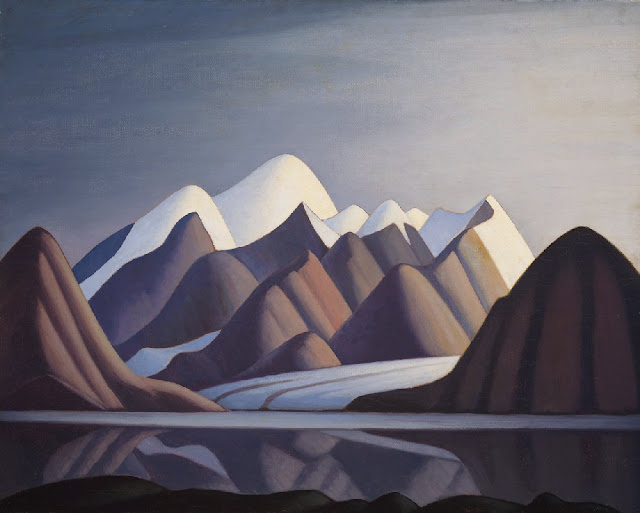
BAFFIN MOUNTAINS BY LAWREN HARRIS


LAWREN S. HARRIS (1885-1970)
mountains (2, 147m to 1, 675m - 7, 044ft to 3, 495ft) 
Canada (Nunavut)

The mountains 
The Baffin Mountains are a mountain range composed by 10 peaks running along the northeastern coast of Baffin Island and Bylot Island, Nunavut, Canada; they are are part of the Arctic Cordillera. The ice-capped mountains are some of the highest peaks of eastern North America. While they could be considered a single mountain range as they are separated by bodies of water to make Baffin Island, this is not true, as they are closely related to the other mountain ranges that make the much larger Arctic Cordillera mountain range.
The highest point is Mount Odin (2,147 m -7,044 ft) while Mount Asgard at (2,015 m -6,611 ft) is perhaps the most famous. The highest point in the northern Baffin Mountains is Qiajivik Mountain (1,963 m -6,440 ft).
Highest Peaks of the Baffin Mountains are :
- Mount Odin (2,147m - 7,044ft)
- Mount Asgard (2,015m - 6,611ft)
- Qiajivik Mountain (1,963m - 6,440ft)
- Angilaaq Mountain (1,951m - 6,401ft)
- Kisimngiuqtuq Peak (1,905m - 6,250ft)
- Ukpik Peak (1,809m - 5,935ft)
- Bastille Peak (1,733m - 5,686ft)
- Mount Thule (1,711m- 5,61ft)
- Angna Mountain (1,710m- 5,610ft)
- Mount Thor (1,675m- 5,495ft)
There are no trees in the Baffin Mountains because the mountains are north of the Arctic tree line. The dominant vegetation in the Baffin Mountains is a discontinuous cover of mosses, lichens and cold-hardy vascular plants such as sedge and cottongrass.
Rocks that comprise the Baffin Mountains are primarily deeply dissected granitic rocks. It was covered with ice until about 1500 years ago, and vast parts of it are still ice-covered. Geologically, the Baffin Mountains form the eastern edge of the Canadian Shield, which covers much of Canada's landscape.
The ranges of the Baffin Mountains are separated by deep fjords and glaciated valleys with many spectacular glacial and ice-capped mountains. The snowfall in the Baffin Mountains is light, much less than in places like the Saint Elias Mountains in southeastern Alaska and southwestern Yukon which are plastered with snow.
The largest ice cap in the Baffin Mountains is the Penny Ice Cap, which has an area of 6,000 km2 (2,300 sq mi). During the mid-1990s, Canadian researchers studied the glacier's patterns of freezing and thawing over centuries by drilling ice core samples.
The Auyuittuq National Park was established in 1976. It features many of Arctic wilderness, such as fjords, glaciers and ice fields. In Inuktitut - the language of Nunavut's Aboriginal people, Inuit - Auyuittuq means "the land that never melts". Although Auyuittuq was established in 1976 as a national park reserve, it was upgraded to a full national park in 2000.
There were Inuit settlements in the Baffin Mountains before European contact. The first European contact is believed to have been by Norse explorers in the 11th century, but the first recorded sighting of Baffin Island was Martin Frobisher during his search for the Northwest Passage in 1576.


The Painter
Lawren Stewart Harris was a leading landscape canadian painter, imbuing his paintings with a spiritual dimension. An inspirer of other artists, he was a key figure in the Group of Seven and gave new vision to representations of the northern Canadian landscape. During the 1920s, Harris's works became more abstract and simplified, especially his stark landscapes of the Canadian north and Arctic. He also stopped signing and dating his works so that people would judge his works on their own merit and not by the artist or when they were painted.

____________________________________________
2019 - Wandering Vertexes...
by Francis Rousseau 

Saturday, June 17, 2017

MOUNT ODIN & BUFFIN MOUNTAINS BY LAWREN HARRIS


LAWREN S.  HARRIS (1885-1970)
 Mount Odin and Baffin mountains (2, 147m to 1, 675m - 7, 044ft to 3, 495ft) 
Canada (Nunavut)


The Mountain 
The Baffin Mountains are a mountain range composed by 10 peaks running along the northeastern coast of Baffin Island and Bylot Island, Nunavut, Canada; they are  are part of the Arctic Cordillera. The ice-capped mountains are some of the highest peaks of eastern North America. While they could be considered a single mountain range as they are separated by bodies of water to make Baffin Island, this is not true, as they are closely related to the other mountain ranges that make the much larger Arctic Cordillera mountain range.
The highest point is Mount Odin (2,147 m -7,044 ft) while Mount Asgard at (2,015 m -6,611 ft) is perhaps the most famous. The highest point in the northern Baffin Mountains is Qiajivik Mountain (1,963 m -6,440 ft).
Highest Peaks of the Baffin Mountains are : 
- Mount Odin  (2,147m - 7,044ft)
- Mount Asgard (2,015m - 6,611ft) 
- Qiajivik Mountain (1,963m - 6,440ft)
- Angilaaq Mountain (1,951m - 6,401ft)
- Kisimngiuqtuq Peak (1,905m -  6,250ft)
- Ukpik Peak (1,809m - 5,935ft)
- Bastille Peak (1,733m - 5,686ft)
- Mount Thule (1,711m- 5,61ft)
- Angna Mountain (1,710m- 5,610ft)
- Mount Thor (1,675m-  5,495ft)
There are no trees in the Baffin Mountains because the mountains are north of the Arctic tree line. The dominant vegetation in the Baffin Mountains is a discontinuous cover of mosses, lichens and cold-hardy vascular plants such as sedge and cottongrass. 
Rocks that comprise the Baffin Mountains are primarily deeply dissected granitic rocks. It was covered with ice until about 1500 years ago, and vast parts of it are still ice-covered. Geologically, the Baffin Mountains form the eastern edge of the Canadian Shield, which covers much of Canada's landscape.
The ranges of the Baffin Mountains are separated by deep fjords and glaciated valleys with many spectacular glacial and ice-capped mountains. The snowfall in the Baffin Mountains is light, much less than in places like the Saint Elias Mountains in southeastern Alaska and southwestern Yukon which are plastered with snow.
The largest ice cap in the Baffin Mountains is the Penny Ice Cap, which has an area of 6,000 km2 (2,300 sq mi). During the mid-1990s, Canadian researchers studied the glacier's patterns of freezing and thawing over centuries by drilling ice core samples.
One of the first mountaineering expeditions in the Baffin Mountains was in 1934 by J.M Wordie, in which two peaks called Pioneer Peak and Longstaff Tower were climbed.
The Auyuittuq National Park was established in 1976. It features many of Arctic wilderness, such as fjords, glaciers and ice fields. In Inuktitut - the language of Nunavut's Aboriginal people, Inuit - Auyuittuq means "the land that never melts". Although Auyuittuq was established in 1976 as a national park reserve, it was upgraded to a full national park in 2000.
There were Inuit settlements in the Baffin Mountains before European contact. The first European contact is believed to have been by Norse explorers in the 11th century, but the first recorded sighting of Baffin Island was Martin Frobisher during his search for the Northwest Passage in 1576.

The Painter
Lawren Stewart Harris  was a leading landscape canadian painter, imbuing his paintings with a spiritual dimension. An inspirer of other artists, he was a key figure in the Group of Seven and gave new vision to representations of the northern Canadian landscape. During the 1920s, Harris's works became more abstract and simplified, especially his stark landscapes of the Canadian north and Arctic.  He also stopped signing and dating his works so that people would judge his works on their own merit and not by the artist or when they were painted.

_______________________________
2017 - Wandering Vertexes...
by Francis Rousseau 

Wednesday, February 15, 2017

MOUNT THULE PAINTED BY LAWREN HARRIS

http://wanderingvertexes.blogspot.com

LAWREN HARRIS (1885-1970)
Mount Thule  (1,711m- 5,614 ft)
Canada - Nunavut

About Nunavut
Nunavut is the newest, largest, and northernmost territory of Canada. It was separated officially from the Northwest Territories on April 1, 1999, via the Nunavut Act and the Nunavut Land Claims Agreement Act, though the boundaries had been contemplatively drawn in 1993. The creation of Nunavut resulted in the first major change to Canada's political map since the incorporation of the province of Newfoundland and Labrador in 1949.

The mountain 
Mount Thule (1,711m- 5,614 ft) is a mountain on Bylot Island, Nunavut, Canada. It is located 38 km (24 mi) north of Pond Inlet on Baffin Island. It is associated with the Baffin Mountains which in turn form part of the Arctic Cordillera mountain system. The Baffin Mountains are ice-capped mountains in which some of the highest peaks of eastern North America.  While they could be considered a single mountain range as they are separated by bodies of water to make Baffin Island, this is not true, as they are closely related to the other mountain ranges that make the much larger Arctic Cordillera mountain range. The highest point is Mount Odin at (2,147 m -7,044 ft) while Mount Asgard (2,015 m - 6,611 ft) is perhaps the most famous. The highest point in the northern Baffin Mountains is Qiajivik Mountain at (1,963 m -6,440 ft). Mount Tule is the fourth highest point (1,711m- 5,614 ft).  Being situated north of the Arctic tree line, there are no trees in the Baffin Mountains but only rocks which are primarily deeply dissected granitic rocks. It was covered with ice until about 1500 years ago, and vast parts of it are still ice-covered.  The dominant vegetation in the Baffin Mountains is a discontinuous cover of mosses, lichens and cold-hardy vascular plants such as sedge and cottongrass.
Geologically, the Baffin Mountains form the eastern edge of the Canadian Shield, which covers much of Canada's landscape. 
One of the first mountaineering expeditions in the Baffin Mountains was in 1934 by J.M Wordie, in which two peaks called Pioneer Peak and Longstaff Tower were climbed. The Auyuittuq National Park was established in 1976. It features many of Arctic wilderness, such as fjords, glaciers and ice fields. In Inuktitut - the language of Nunavut's Aboriginal people, Inuit - Auyuittuq means "the land that never melts". Although Auyuittuq was established in 1976 as a national park reserve, it was upgraded to a full national park in 2000.
There were Inuit settlements in the Baffin Mountains before European contact. The first European contact is believed to have been by Norse explorers in the 11th century, but the first recorded sighting of Baffin Island was Martin Frobisher during his search for the Northwest Passage in 1576.

The painter 
Lawren Stewart Harris, (1885–1970) was a leading landscape canadian painter, imbuing his paintings with a spiritual dimension. An inspirer of other artists, he was a key figure in the Group of Seven and gave new vision to representations of the northern Canadian landscape. During the 1920s, Harris's works became more abstract and simplified, especially his stark landscapes of the Canadian north and Arctic.  He also stopped signing and dating his works so that people would judge his works on their own merit and not by the artist or when they were painted.
In 1924, a sketching trip with A.Y. Jackson to Jasper National Park in the Canadian Rockies marked the beginning of Harris' mountain subjects, which he continued to explore with annual sketching trips until 1929, exploring areas around Banff National Park, Yoho National Park and Mount Robson Provincial Park. In 1930, Harris went on his last extended sketching trip, travelling to the Arctic aboard the supply ship SS. Beothic for two months, during which time he completed over 50 sketches.  "We are on the fringe of the great North and its living whiteness, its loneliness and replenishment, its resignations and release, tis call and answer, its cleansing rhythms. It seems that the top of the continent is a source of spiritual flow that will ever shed clarity into the growing race of America."(Lawren S. Harris, 1926)
For Harris, art was to express spiritual values as well as to represent the visible world. North Shore, Lake Superior (1926), an image of a solitary weathered tree stump surrounded by an expanse of dramatically lit sky, effectively evokes the tension between the terrestrial and spiritual.
The resulting Arctic canvases that he developed from the oil panels marked the end of his landscape period, and from 1935 on, Harris enthusiastically embraced abstract painting. Several members of the Group of Seven later became members of the Canadian Group of Painters including Harris, A. J. Casson, Arthur Lismer, A. Y. Jackson, and Franklin Carmichael.
From 1934 to 1937, Harris lived in Hanover, New Hampshire, where he painted his first abstract works, a direction he would continue for the rest of his life. In 1938 he moved to Sante Fe, New Mexico, and helped found the Transcendental Painting Group, an organization of artists who advocated a spiritual form of abstraction.
In 1969, he was made a Companion of the Order of Canada.
Harris died in Vancouver in 1970, at the age of 84, as a well-known artist. He was buried on the grounds of the McMichael Canadian Art Collection, where his work is now held.
On November 26, 2015 his painting Mountain and Glacier was auctioned for $3.9 million at a Heffel Fine Art Auction House auction in Toronto, breaking the previous record for the sale of one of Harris's works.
In 2016 a film about Harris's life, Where the Universe Sings, was produced by TV Ontario. It was created by filmmaker Peter Raymont and directed by Nancy Lang.

_______________________________
2017 - Wandering Vertexes...
by Francis Rousseau