google.com, pub-0288379932320714, DIRECT, f08c47fec0942fa0 GRAVIR LES MONTAGNES... EN PEINTURE: Search results for Norway
Showing posts sorted by relevance for query Norway. Sort by date Show all posts

Tuesday, February 1, 2022

THE GRINDELWALD GLACIER PAINTED BY THOMAS FEARNLEY

THOMAS FEARNLEY  (1802-1842) The Grindelwald Glacier  (1, 349 m - 4, 425m) Switzerland   In The Grindelwald Glacier, oil on canvas  1838, 194 x 157 cm, Nasjonalmuseet, Oslo

 
THOMAS FEARNLEY  (1802-1842)
The Grindelwald Glacier  (1, 349 m - 4, 425m)
Switzerland (Bernese Alps)

 In The Grindelwald Glacier, oil on canvas  1838, 194 x 157 cm, Nasjonalmuseet, Oslo


About the painting
In The Grindelwaldgletscher, the highlight of Thomas Fearnley’s Swiss landscape paintings, the viewer gazes up from the grassy knoll in the foreground toward the bottom of a valley filled by a glacier. The majestic composition is based on Fearnley’s on-site observations. A sketch in pencil from August 1835 reveals a barren landscape in front of the glacier. The large trees, which form such an essential part of the picture’s overall composition, stem from studies of trees Fearnley made a week later in Scheideck. Fearnley has made the landscape more overpowering than in the original on-site drawing. The mountainsides are steeper and have been accentuated through light and shadow. The contrast to the everlasting ice and snow of the desolate valley is heightened by the lush vegetation in the foreground, where sheep graze under a shepherd’s supervision. Fearnley emphasizes the wild, inaccessible aspects of nature by letting a bird of prey glide above the glacier, even as he playfully includes a visual, English-based pun on his name by adding a tuft of fern next to his signature.
Scholars have noted how the composition and the balancing of the various landscape elements evoke the Düsseldorf painter Johann Wilhelm Schirmer (1807–63), whom Fearnley met during his sojourn in Switzerland. In romanticism, a pronounced contrast between warm and cold tones, as seen here, was also perceived as symbolizing the confrontation between life and death. Before the painting was completed, it was shown at the Paris Salon in 1836. Along with two paintings by J. C. Dahl, this painting and Fearnley’s The Labro Falls at Kongsberg (1837) were the first paintings by Norwegians artists to be acquired by the National Gallery.

The glacier
The Lower Grindelwald Glacier also known as the Lower Grindelwald Glacier is a glacier in the Bernese Alps, located southeast of Grindelwald, in the canton of Bern (Swiss). It originates under the Agassizhorn and the Strahlegghorn and is connected to the Unteraar glacier via the Finsteraarjoch (3,283 m). The Lower Grindelwald Glacier should not be confused with the Upper Grindelwald Glacier, located to the northeast. The Lower Grindelwald Glacier still has a major tributary, the Ischmeer (“sea of ​​ice” in Swiss German, formerly known as the “Grielwald-Fiescher Glacier”, German: Grindelwald-Fieschergletscher3), which is the glacier overlooked by the Eismeer station of the Jungfrau Railway.
The Lower Grindelwald Glacier was 8.3 km long and covered an area of ​​20.8 km2 in 1973. It has shrunk considerably since, being only 6.2 km long in 2015, the 1.9 km retreat being mainly intervened since 2007. In the middle of the 19th century, the glacier reached the valley of Grindelwald as far as Mettenberg, at an altitude of 983 m, near the confluence of the white Lütschine and the black Lütschine. In 1900 it still extended to the Rotenflue (1,200 m) and filled the whole valley from its present end, the glacial lake, with a thickness of about 300 m up to an altitude of 1,700 m, just below the current hiking trail around the Bänisegg. In the early 2000s, it had retreated to the gorge between the Hörnli (Eiger) ridge and the Mättenberg. 

The painter
Thomas Fearnley attended National Cadet Corps from 1814 to 1819. He was a student of the Norwegian National Academy of Craft and Art Industry (1819–1821), Art Academy in Copenhagen (1821–1823) and the Art Academy (n Stockholm (1823–27) under Carl Johan Fahlcrantz. Fearnley left Copenhagen bound for Stockholm in the autumn of 1823 to complete a painting commissioned by Crown Prince Oscar of Norway and Sweden. He received several orders from the Swedish royal family and from other members of the royal court including Swedish Count Gustaf Trolle-Bonde. He conducted study tours in Norway (1824-1826), at which time he met Johan Christian Dahl in Sogn. After another stay in Copenhagen from 1827 to 1828 and a new Norwegian trip in the autumn of 1828, he went to Germany and was a student of Dahl in Dresden (1829–1830) as well as befriending the German painter Joseph Petzl and the German-Danish painter Friedrich Bernhard Westphal. He lived in Munich (1830–32). Fearnley traveled extensively in the 1830s, visiting Munich, Paris, London, Hull and the English Lake district. During September 1832, he went from Venice to Rome and visited Sicily the following summer. He mostly painted in small towns south of Naples: Castellammare, Amalfi, Sorrento, Capri and in Switzerland: Meiringen, Grindelwald. He went to Paris in the summer of 1835 and visited London the next year. During the summer of 1839 he was on a study tour to the Sognefjord and Hardangerfjord, together with the German painter Andreas Achenbach. Fearnley's paintings alternate between oil sketches and larger, composed landscapes meant for exhibition. His large studio compositions have a cool monumental attitude with a taste for the powerful and wildly romantic in the favorite motifs, wilderness and waterfalls, and with a strong emphasis on the image's architectural structure. The National Gallery in Oslo owns a total of 54 of his smaller pictures and sketches and also a series of drawings. Notable works in this collection include Labrofossen (1837), Grindelwaldgletsjeren (1838) and Slinde Birken (1839). Other notable collections are located in the Bergen Kunstmuseum and the Nationalmuseum in Stockholm.

___________________________________________

2022 - Wandering Vertexes...
by Francis Rousseau

Monday, December 31, 2018

KVASSTINDEN & BREITINDEN PAINTED BY EVEN ULVING


 EVEN ULVING (1863 - 1952)
  Kvasstinden (1,010 m -3,313ft ) 
Breitinden (910 m - 2,985ft) 
Norway 

In  Motiv of Helgeland. Winter landscape with reindeer, oil on canvas, 1906,
Royal Palace Collection, Oslo

The mountains 
 Kvasstinden (1,010 m -3,313ft )  and Breitinden (910 m - 2,985ft) are part of the The Seven Sisters,  a mountainous massif of Norway located on the island of Alsten, in the county of Nordland, southwest of Mo i Rana. From north-east to south-west, the seven summits are:  Botnkrona (1,072 m - 3517ft)),  Grytfoten (1,019 m -3, 343ft),  Skjæringen (1,037 m- 3,402ft), Tvillingene ("the Twins") (945 m- 3,100ft  and 980 m - 3,215ft),  Kvasstinden  (1,010 m -3,313ft)  and  Breitinden (910 m - 2,985ft).

The painter 
Even Christophersen Ulving (was a Norwegian painter.  At the age of 18, he traveled to Kristiania to learn his craft with Wilhelm von Krogh  In 1883/84 he was a student at Knud Bergslien's painting school, in 1885/86 by Heinz Heim and Carl Frithjof Smith at the Kunstakademie in Munich, and in 1887 by William Adolphe Bouguereau at the Académie Julian in Paris.
Ulving painted naturalistic, mostly motifs from Helgeland or Vestfold . He especially understood how to portray the characteristic colors of the different seasons in a variety of often powerful tones, without causing any discord. His landscapes always show human activities or traces of it. He also likes to paint rural genre scenes in huts and living rooms.
Pictures of him hanging in the royal castle, and also the National Museum Oslo recently bought two works by him.
_______________________________

2018 - Wandering Vertexes...
by Francis Rousseau 

Tuesday, October 5, 2021

MOUNT MARCY PAINTED BY JONAS LIE


JONAS LIE (1880-1940) Mount Marcy (1,629m - 5,343ft) United States of America (Essex County)  In Snow - Adirondacks, Private collection (Christie's)

 
JONAS LIE (1880-1940)
Mount Marcy (1,629m - 5,343ft)
United States of America (Essex County)

In Snow - Adirondacks, Private collection (Christie's)


The mountain
Mount Marcy (1,629m - 5,343ft) in Mohawk langage Tewawe’estha is the highest point in New York State. It is located in the Town of Keene in Essex County. The mountain is in the heart of the Adirondack High Peaks Region of the High Peaks Wilderness Area. Its stature and expansive views make it a popular destination for hikers, who crowd its summit in the summer months.
Lake Tear of the Clouds, at the col between Mt. Marcy and Mt. Skylight, is often cited as the highest source of the Hudson River, via Feldspar Brook and the Opalescent River, even though the main stem of the Opalescent River has as its source a higher point two miles north of Lake of the Clouds, and that stem is a mile longer than Feldspar Brook.
The mountain is named after Gov. William L. Marcy, the 19th-century Governor of New York, who authorized the environmental survey that explored the area. Its first recorded ascent was on August 5, 1837, by a large party led by Ebenezer Emmons looking for the source of the East Fork of the Hudson River.  Today the summit may be reached by multiple trails; though long by any route, a round-trip may be made in a day.

The painter
Jonas Lie was a Norwegian-born American painter. He is best known for colorful paintings of coastlines of New England and city scenes of New York City.
Between 1901 and the memorial exhibition in 1940 his work was shown all over America. In 1905 Lie exhibited 34 pictures in the Pratt Institute, Brooklyn Museum of Art. Between 1905 and 1938 Lie had 57 one-man shows, each including from 12 to 45 paintings. He participated in important annual and biennial exhibitions at the National Academy of Design, the Pennsylvania Academy of the Fine Arts, the Art Institute of Chicago, and the Corcoran Gallery of Art in Washington as well as most of the world fairs. While living in Panama in 1913, he painted scenes of the construction of Panama Canal which were later donated to U.S. Military Academy at West Point in memory of the West Pointer who, as chief engineer, was most potent in channeling the isthmus, General George W. Goethals. In 1932, Jonas Lie was awarded the Knight of Order of St. Olav by the King of Norway.
Jonas Lie often depicted the sea, channels, and ships with dramatic perspective and powerful use of color. He became known for colorful impressionistic scenes of harbors & coves, painted during the many summers he spent on the coasts of New England & Canada. Throughout his prolific career he painted brilliantly colored images of the rocky coves and harbors that identify the region's dramatic shoreline.

___________________________________________

2021 - Wandering Vertexes...
by Francis Rousseau

Wednesday, August 1, 2012

THE GROSSGLOKNER PAINTED BY EDWARD T. COMPTON


EDWARD THEODORE COMPTON  (1849-1921)
Grossglockner  (3,798 m-12,461 ft) 
Austria

in 1918 - Alpenverein Museum Inssbruk

The mountain  
The Grossglockner (or just Glockner) is at (3,798 meters-12,461 ft) above the Adriatic, the highest mountain of Austria and the highest mountain in the Alps east of the Brenner Pass. It is part of the larger Glockner Group of the Hohe Tauern range, situated along the main ridge of the Central Eastern Alps and the Alpine divide. The Pasterze, Austria's most extended glacier, lies on the Grossglockner's eastern slope. The characteristically pyramid-shaped peak actually consists of two pinnacles, the Grossglockner and the Kleinglockner (3,770 m (12,370 ft), from German: klein, "small"), separated by a saddle-like formation known as the Glocknerscharte.
The history of the climbs started with French-born natural scientist Belsazar Hacquet, from 1773 professor of anatomy at the Academy of Ljubljana. He travelled the Eastern Alps from 1779 to 1781 and published an itinerary in 1783, describing the Glokner mountain and stating that it had not been climbed yet. He estimated the mountain's height with converted 3,793 m (12,444 ft) and left an engraving illustrating Grossglockner and Pasterze, the first known depiction of the mountain.
Inspired by Hacquet's book and the first ascent of the Mont Blanc in 1786, the Gurk prince-bishop Count Franz Xaver of Salm (1749–1822) together with his vicar general Sigismund Ernst Hohenwart (1745–1825) and Baron Franz Xaver von Wulfen (1728–1805) started efforts for a Grossglockner expedition. They engaged two peasants from Heiligenblut as mountain guides to do the first explorations for an ascent through the Leitertal valley, which is the side of Grossglockner with the least ice (people feared glaciers in these times). These valiant men, called "Glockners" in the records, did more than they were ordered to do - and probably reached the Kleinglockner summit on 23 July 1799.
One month later the bishop's expedition started: a mountain hut (the first Salm Hut) had been built and the path in the Leitertal valley was prepared so that the bishop could use a horse to reach it. 30 people, among them Salm, Hohenwart and Wulfen, were part of the expedition. They suffered with bad weather and a first effort failed, but on 25 August 1799 Hohenwart and at least four other people, including the two "Glockners", reached - again - the Kleinglockner, where they installed one of the first summit crosses (one of the main goals of the church expedition). Hohenwart's reports did not tell clearly that they had not touched the highest point but Bishop Salm (who had reached the Adlersruhe rock at 3,454 m (11,332 ft)) was informed. Dissatisfied, he invited another, even bigger expedition the next year.
On 28 July 1800, 62 people, among them the pedagogue Franz Michael Vierthaler and the botanist David Heinrich Hoppe, started again into the Leitertal valley. Four peasants and carpenters (the "Glockners" and two others who are not known) did a track in the snow, had installed fixed ropes at some steeper sections up to the end of the Glocknerleitl, and even built a second refuge, called Hohenwarte Hut. The vanguard reached the Kleinglockner peak, however, according to the expedition records by the Dellach priest Franz Joseph Horasch (Orasch), only the four guides and Mathias Hautzendorfer, the local priest of the Rangersdorf parish, were able to cross the Obere Glocknerscharte and climb the Grossglockner summit. Hautzendorfer had to be persuaded to venture the step and administered the last rites in advance.
The two "Glockners" are usually identified as the brothers Joseph (Sepp) and Martin Klotz, however, this surname is not listed in the Heiligenblut parish register. A local peasant named Sepp Hoysen is documented as a member of the second Grossglockner expedition in 1802, and the surveyor Ulrich Schiegg mentioned one Martin Reicher as "Glockner" guide. The peasants and several other members of the expedition (among them Schiegg and his young apprentice Valentin Stanič, who climbed Mt. Watzmann for the first time some weeks later) did the ascent again the next day and finally installed the summit cross and a barometer on the Grossglockner summit.
Bishop Salm undertook two more ascents in 1802 (with Hohenwart reaching the summit) and in 1806, however, he himself never climbed beyond the Adlersruhe rock. The climbing of the Grossglockner was also described by the botanist Josef August Schultes, who explored the massif together with Count Apponyi in 1802. No further ascents were made during the Napoleonic Wars, the huts decayed and were plundered by locals. In the following Vormärz era, however, the mountain became a popular venue for Alpinists like Hermann and Adolf Schlagintweit, who all followed the route of the first ascent.
By the mid 19th century, the developing Alpine tourism began to alter the traditional agriculture economy in the Heiligenblut area. Therefore, the people of Kals tried to lay out a straight ascent from the western side, which however was not reached until Julius von Payer explored the ridge between Glöcknerleitl and Ködnitzkees in 1863. Johann Stüdl had a via ferrata erected along the southwestern ridge the next year and the Stüdlhütte erected at its foot in 1868. Already in 1869, most expeditions to the summit started in Kals. The first winter ascent of the Grossglockner was made on January 2, 1875 by William Adolf Baillie Grohman, a member of the Alpine Club. In 1876 Count Pallavicini and his guide Hans Tribusser undertook the first expedition up the steep glaciated Northeast Face, chopping 2,500 steps into the Pallavicinirinne in an ice climbing master stroke not repeated for 23 years.
In 1879, Count Pallavicini dedicated a new iron summit cross on the occasion of the silver wedding of Emperor Franz Joseph of Austria and Empress Elisabeth; both had visited Heiligenblut and walked to the present-day Franz-Josefs-Höhe viewpoint in 1865. The cross was installed on 2 October 1880. Pallavicini also had the Archduke John Hut erected at the former Adlersruhe resting place of Bishop Salm, today the highest situated mountain hut in Austria. The Austrian Alpine Club built the new Salmhütte and the Glocknerhaus along the alpine route from Heiligenblut.
A first ascent by skiing was made in 1909 and the circumnavigation of the massif soon became a popular ski mountaineering tour. The Grossglockner became Austria's highest mountain, when the South Tyrolean Ortler region had to be ceded to the Kingdom of Italy according to the 1919 Treaty of Saint-Germain, which promoted its reputation as a tourist attraction.

The Painter 
Edward Theodore Compton, usually referred to as E. T. Compton, (29 July 1849 – 22 March 1921) was an English-born, German artist, illustrator and mountain climber, not to be confused with his son Edward Harrison Compton, also a mountain painter. He is well known for his paintings and drawings of alpine scenery, and as a mountaineer made 300 major ascents including no fewer than 27 first ascents.
Initially painting in the English romantic tradition, Compton later developed a more realistic representation of nature, being guided by his true artistic ideas while retaining topographical accuracy. Even his early watercolors show the great importance of brightness and light and his work is also remarkable for its portrayal of the elements such as water and air, including ascending mist and fog. He can be regarded as an impressionist.
He attended various art schools, including, for a time, the Royal Academy in London, but otherwise he was mainly self-taught in art. In 1867, wanting the best education for their artistically-talented son, and due to the high cost of schooling in England, the family decided to emigrate to Germany settling in Darmstadt. The city at that time was the seat of the Grand Duchy of Hesse under Grand Duke Ludwig III, and a community of artists had sprung up there. Entries in Compton's diary show that both he and his father were art teachers - Alice, the Princess of Hesse numbered amongst Edward's students.
Between 1867-68 Compton toured the Rhineland, Mosel and Eifel areas of Germany, making numerous sketches. In July 1868, the entire Compton family traveled to the Bernese Oberland, the alpine scenery encountered during this trip, particularly the view of the Eiger, Mönch and Jungfrau peaks, inspiring Edward to become a mountain painter.
In 1869, Compton was living in Munich and two years later for the first time exhibited his work at the Glass Palace.
In 1872 he married Auguste Plotz and for two years they travelled through the Tyrol, Carinthia, Italy and Switzerland. From 1874, the couple settled in Feldafing on Lake Starnberg, building a comfortable house there called Villa Compton.
In the following years, Compton travelled to the mountains of Austria, Scandinavia, North Africa, Corsica and Spain recording his impressions in a variety of oil and watercolors paintings and ink drawings. Although alpine scenes predominated, Compton also visited and drew other areas such as the High Tatras in eastern Europe, the Scottish Highlands, the Hebrides, the Lofoten Islands and Northern Cape in Norway, and the Colombian Andes.
In 1880 Compton became a member of the Royal Academy, London. Besides his work as a painter he also became well known as a book illustrator for the German and Austrian Alpine Association (DAV) with titles such as "In the high mountains" by Emil Zsigmondy (1889), "About Fels and Firn" by H. Hess (1901) and "Mountaineering in Pictures" by Alfred Steinitzer (1913). In England he was also in demand as an illustrator providing pictures for a range of titles (see below).
In 1909 Compton accompanied his friend, the mountaineer Karl Blodig on many tours in the Silvretta mountains. At the time of the First World War he was invited by the Austrian army to paint from the mountain front but was forbidden to do so by the Bavarian High Command. He was also excluded from the Munich Artists' Association, because he was English.
Apart from his art, Compton was also an excellent climber, highly regarded by Blodig for his "brilliant mountaineering skill on ice and rock, his truly admirable perseverance, his inexhaustible patience in bearing hardships". He was a member of the exclusive Alpine Club and the German and Austrian Alpine Association (DAV).
Amongst his notable ascents were: Torre di Brenta first climbed in 1882; Cima Brenta, first climbed by the south wall in 1882; Odle} (Large Fermeda); Aiguille Blanche de Peuterey (ascent in 1905 with Karl Blodig); Grossglockner, climbed at the age of 70!
Compton died in Feldafing on 22 July 1921, aged 72. His son Edward Harrison Compton and daughter Dora Compton were also mountain painters. His other daughter Marion was a flower and still life painter.

Thursday, October 21, 2021

MONTE CIVETTA PAINTED BY ELIJAH WALTON


ELIJAH WALTON (1832-1880), Monte Civetta (3,220 m - 10, 580 ft) Italy  In Dolomites - in Spring. Civetta from Forcella Staulanza (North East), 1875 oil on canvas, 38 x 183 cm
 
ELIJAH WALTON (1832-1880)
Monte Civetta (3,220 m - 10, 580 ft)
Italy

In Dolomites - in Spring. Civetta from Forcella Staulanza (North East), 1875 oil on canvas, 38 x 183 cm.


The mountain
Monte Civetta (3,220 m - 10, 580 ft) is a prominent and major mountain of the Dolomites, in the Province of Belluno in northern Italy. Its north-west face can be viewed from the Taibon Agordino valley, and is classed as one of the symbols of the Dolomites. The mountain is thought to have been first climbed by Simeone di Silvestro in 1855, which, if true, makes it the first major Dolomite peak to be climbed. The north-western face, with its 1,000-metre-high cliff, was first climbed in 1925 by Emil Solleder and Gustl Lettenbauer. It is historically considered the first "sixth grade" in six-tier scale of alpinistic difficulties proposed by Willo Welzenbach (corresponding to 5.9). Thirty years later UIAA used this as a basis for its grading system. The famed Svan mountain climber Mikhail Khergiani died in a climbing accident on Monte Civetta in 1969.

The artist
The British landscapist, Elijah Walton is best known for his landscapes of mountains in the Alps. Due to the poorness of his family, without the help of one or two friends he would have been unable to study art, for which his talent was soon exhibited. After passing some years at the art academy in Birmingham, he became at the age of eighteen a student at the Royal Academy Schools in London, where he had already exhibited a picture. There he worked assiduously, drawing from the antique and from life. Nearly ten years later an accidental circumstance revealed to a friend his capabilities in mountain landscape, and in 1860, immediately after his marriage, he went to Switzerland. Thence he proceeded to Egypt, where unhappily his wife died of dysentery near the second cataract. He remained in the east, spending some time in Syria and at Constantinople, till the spring of 1862, when he returned for a short time to London. But for the next five years he was much abroad, working either in the Alps or in Egypt. His sketching tours then became rarer and shorter, though he visited Greece, Norway, and the Alps. At first he resided at Staines, then removed to the neighbourhood of Bromsgrove, living most of the time at the Forelands, near that town. In 1872 his wife died, and the loss permanently affected his health. He died on 25 August 1880 at his residence Beacon Farm, Lickey near Bromsgrove in Worcestershire, leaving three sons. Walton's life was bound up in his art. He worked both in oils and in watercolours, but was more successful with the latter. Most thorough and conscientious in the study both of form and of colour, he delighted especially in mountain scenery and in atmospheric effects, such as an Alpine peak breaking through the mists, or a sunset on the Nile. Few men have equalled him in the truthful rendering of rock structure and mountain form. His pictures were much appreciated by lovers of nature; but as those of small size sold better than larger and more highly finished works, this fostered a tendency to mannerisms.

___________________________________________
2021 - Wandering Vertexes...
by Francis Rousseau

Wednesday, May 30, 2018

MOUNT KHUMBILA / KHUMBU YUL-LHA BY HEINRICH C. BERANN


HEINRICH C. BERANN  (1915-1999)
Mount Khumbila / Khumbu Yul-Lha (5,761 m- 18, 901ft) 
Nepal 

In Kumbu Himal map, 1950 for National Geographic 

The mountain 
Mount Khumbila or Khumbu Yul-Lha (5,761 m- 18, 901ft)  roughly translated as "God of Khumbu" is one of the high Himalayan peaks in the Khumbu region of Eastern Nepal within the boundaries of Sagarmatha National Park. Considered too sacred to be climbed by most local Sherpa people, the mountain is considered home to the patron God of the local area. The mountain overlooks the famous southern approaches to its larger neighbours including Ama Dablam and Mount Everest.
Khumbila has never been climbed; one attempt prior to the 1980s ended when climbers were killed in an avalanche, and there have been no subsequent attempts.
Khumbila is said to be a god, and an old one. The prayers for Khumbila are believed to date back to the time when the ancestors of the Sherpas were still in Tibet (more than 500 years ago). Khumbila is said to have been subdued and converted to Buddhism by Guru Rimpoche, the 8th-century saint who spread Buddhism throughout the Himalaya . In fact, Guru Rimpoche is said to have spent some time meditating in a cave above Khunde, perhaps on the mountain Khumbila itself.
Local buildings often have prayer flags on bamboo wands to honour Khumbila.

The artist
Heinrich C. Berann, (1915–1999) the father of the modern panorama map, was born into a family of painters and sculptors in Innsbruck, Austria. He taught himself by trial and error. In the years 1930-1933 he attended the arts and design school "Bundeslehranstalt für Malerei" in Innsbruck.
Winning of first prize at a competition for a panorama map created great enthusiasm in him. Using his artistic heritage and new self-discovered techniques he invented a new way of painting landscapes for tourist purposes. The further development of both these panorama maps and his artistic style was influenced by lasting impressions he received during his military service in German Army in Norway and Northern Finland in 1942.
In 1962 he painted Mount Everest for the National Geographic Society, one of his most famous panoramic maps. He worked with Marie Tharp and Bruce C. Heezen to produce maps of the entire ocean floor in 1977.
He later created four panoramas for the United States National Park Service: Yellowstone National Park, North Cascades National Park, Yosemite National Park and finally Mt. McKinley National Park (now Denali). He was very sick when he painted Denali (above) - but he finished it in the age of 81.
In 2000, Tom Patterson of the National Park Service explored ways of digitally creating panoramas like Berann did for the Park Service.

Sunday, March 25, 2018

MOUNT DENALI MAP BY HEINRICH. C. BERANN


HEINRICH  C. BERANN (1915 - 1999) 
Mount Denali, ex Mount Mc Kinley (6,190 m - 20,310 ft)
United States of America (Alaska)

 In Denali map for US National Park Service, 1995.

The mountain 
Denali (also known as Mount McKinley, see the Naming paragraph below)) is the highest mountain peak in North America, with a summit elevation of  6,190 m - 20,310 feet above sea level. Denali is the third most prominent and third most isolated peak after Mount Everest and Aconcagua.  Denali  is one of the Seven Summit, which includes the highest mountains of each of the seven  continents. Summiting all of them is regarded as a mountaineering  challenge, first achieved on April 30, 1985 by Richard Bass.  The seven summit are :
Mount Everest (8,848m), Aconcagua (6,961m), Mt Denali or Mc Kinley (6,194m),  Kilimandjaro (5,895m), Mt Elbrus (5,642m), Vinson  Massif (4,892m), Mt Blanc (4,807m) and Mount Kosciuszko (2,228m) in Australia.
Located in the Alaska Range in the interior of the U.S. state of Alaska, Denali is the centerpiece of Denali National Park and Preserve.
Denali has two significant summits: the South Summit is the higher one, while the North Summit has an elevation of 19,470 ft (5,934 m) and a prominence of approximately 1,270 ft (387 m).  The North Summit is sometimes counted as a separate peak (see e.g., fourteener) and sometimes not; it is rarely climbed, except by those doing routes on the north side of the massif.
Five large glaciers flow off the slopes of the mountain. The Peters Glacier lies on the northwest side of the massif, while the Muldrow Glacier falls from its northeast slopes. Just to the east of the Muldrow, and abutting the eastern side of the massif, is the Traleika Glacier. The Ruth Glacier lies to the southeast of the mountain, and the Kahiltna Glacier leads up to the southwest side of the mountain.  With a length of 44 mi (71 km), the Kahiltna Glacier is the longest glacier in the Alaska Range.
The Koyukon Athabaskans who inhabit the area around the mountain have for centuries referred to the peak as Dinale or Denali. The name is based on a Koyukon word for "high" or "tall".  During the Russian ownership of Alaska, the common name for the mountain was Bolshaya Gora (Russian: Большая Гора, meaning Russian "big mountain)" which is the Russian translation of Denali.  It was briefly called Densmore's Mountain in the late 1880s and early 1890s after Frank Densmore, an Alaskan prospector who was the first European to reach the base of the mountain.
In 1896, a gold prospector named it McKinley as political support for then-presidential candidate William McKinley, who became president the following year. The United States formally recognized the name Mount McKinley after President Wilson signed the Mount McKinley National Park Act of February 26, 1917.  
In 1965, Lyndon B. Johnson declared the north and south peaks of the mountain the "Churchill Peaks", in honor of British statesman Winston Churchill.  The Alaska Board of Geographic Names changed the name of the mountain to Denali in 1975, which was how it is called locally.  However, a request in 1975 from the Alaska state legislature to the United States Board on Geographic Names to do the same at the federal level was blocked by Ohio congressman Ralph Regula, whose district included McKinley's hometown of Canton.
On August 30, 2015, just ahead of a presidential visit to Alaska, the Barack Obama administration announced the name Denali would be restored in line with the Alaska Geographic Board's designation. 

The artist
Heinrich C. Berann, (1915–1999) the father of the modern panorama map, was born into a family of painters and sculptors in Innsbruck, Austria. He taught himself by trial and error. In the years 1930-1933 he attended the arts and design school "Bundeslehranstalt für Malerei" in Innsbruck.
Winning of first prize at a competition for a panorama map created great enthusiasm in him. Using his artistic heritage and new self-discovered techniques he invented a new way of painting landscapes for tourist purposes. The further development of both these panorama maps and his artistic style was influenced by lasting impressions he received during his military service in German Army in Norway and Northern Finland in 1942.
In 1962 he painted Mount Everest for the National Geographic Society, one of his most famous panoramic maps. He worked with Marie Tharp and Bruce C. Heezen to produce maps of the entire ocean floor in 1977.
He later created four panoramas for the United States National Park Service: Yellowstone National Park, North Cascades National Park, Yosemite National Park and finally Mt. McKinley National Park (now Denali). He was very sick when he painted Denali (above) - but he finished it in the age of 81.
In 2000, Tom Patterson of the National Park Service explored ways of digitally creating panoramas like Berann did for the Park Service.

Thursday, November 8, 2018

MONTE DURANNO BY CARL HUMMEL

 http://wanderingvertexes.blogspot.com

Carl Hummel (1821-1907)
Monte Duranno  (2,652 m - 8, 700 ft) 
Italy 

In Ansicht von Pieve di Cadore, oil on canvas,  (130 x 180 cm), 1902, Private collection  

The mountain 
Mount Duranno  (2,652 m - 8, 700 ft)  is a mountain in the Friulian Dolomites, more precisely called the Dolomiti d 'Oltre Piave , in the Carnic Prealps in Italy . It is located between the Veneto (province of Belluno) and in Friuli-Venezia Giulia (province of Pordenone). It is a mountain of the Cima dei Preti Group -Duranno, partly included in the natural park of the Friulian Dolomites. One can climb the mountain from the Maniago refuge.

The painter

The german landcape painter and etcher Carl Maria Nicolaus Hummel was the son of Austrian composer Johann Nepomuk Hummel and the opera singer Elisabeth Röckel. His studies began in 1841 under Friedrich Preller at the Fürstliche freie Zeichenschule Weimar. After graduating, he made several study trips to England, Norway, Rügen and the Tyrol, lingering in Italy and Sicily until 1846. Upon his return, he settled in Weimar, where he became a professor at the Weimar Saxon-Grand Ducal Art School in 1860. His paintings focus primarily on the Italian and Tyrolean Alps. They are widely displayed at museums throughout Northern Europe, including the Musée de la Vie Romantique in Paris.

_______________________________
2018 - Wandering Vertexes...
by Francis Rousseau 

Saturday, December 1, 2018

HEIRDUBREIT SKETCHED BY AASMUND FRISAK


AASMUND FRISAK (1852 – 1935) 
Herdubreit  (1,682 m - 5,518 ft)
Iceland

 In Herdubreit as seen from  Mördrudal, The British Library

The mountain 
Herdubreit  (1,682 m - 5,518 ft)   (Herðubreið in idelandic)) is a tuya in north-east Iceland.
A tuya is a type of distinctive, flat-topped, steep-sided volcano formed when lava erupts through a thick glacier or ice sheet. They are somewhat rare worldwide, being confined to regions which were covered by glaciers and had active volcanism during the same period.
Discovering and dating the lava flows in a tuya has proven useful in reconstructing past glacial ice extents and thicknesses.
Herdubreit  is situated in the Highlands of Iceland at the east side of the Ódáðahraun desert and close to Askja volcano. The desert is a large lava field originating from eruptions of Trölladyngja and other shield volcanoes in the area. Herðubreið was formed beneath the icesheet that covered Iceland during the last glacial period. Due to the mountain's steep and unstable sides, the first ascent was in 1908 despite centuries of knowledge of its existence. Near the mountain lies an oasis called Herðubreiðarlindir with a campground and hiking trails. In former times, outcasts who had been excluded from Icelandic society because of crimes they had committed lived at the oasis.[citation needed] One such outlaw was Fjalla-Eyvindur, who lived there during the winter of 1774–1775.

The artist 
Aasmund Frisak (20 March 1852 – 1935) was a Norwegian naval officer and politician for the Conservative Party. He graduated from the Norwegian Naval Academy in 1872. After running the sailors' school in Fredrikshald from 1878 to 1887 he returned to Horten as teacher at the Norwegian Naval Academy from 1891 to 1897. In 1897 he was hired at the Karljohansvern shipyard. He held the ranks of Captain from 1894 and Commander from 1899. He was also a local bank director. From 1901 to 1904 he served as mayor of Horten municipality, and he was elected to the Parliament of Norway in 1903, representing the rural constituency of Jarlsberg og Larviks Amt.

_______________________________
2018 - Wandering Vertexes...
by Francis Rousseau 

Thursday, January 9, 2020

MOUNT BAKER / KULSHAN PAINTED BY JONAS LIE


JONAS LIE  (1880-1940)
Mount Baker / Kulshan ((3,286 m - 10,781 ft
United States of America

In Mount Baker, 1925, oil on canvas, Courtesy Saranac Lake Free Library

The mountain
Mount Baker ((3,286 m - 10,781 ft), also known as Koma Kulshan or simply Kulshan, is a active glaciated andesitic stratovolcano in the Cascade Volcanic Arc and the North Cascades of Washington in the United States. Mount Baker has the second-most thermally active crater in the Cascade Range after Mount Saint Helens. About 30 miles (48 km)[due east of the city of Bellingham, Whatcom County, Mount Baker is the youngest volcano in the Mount Baker volcanic field. While volcanism has persisted here for some 1.5 million years, the current glaciated cone is likely no more than 140,000 years old, and possibly no older than 80–90,000 years. Older volcanic edifices have mostly eroded away due to glaciation.
After Mount Rainier, Mount Baker is the most heavily glaciated of the Cascade Range volcanoes; the volume of snow and ice on Mount Baker, 0.43 cu mi (1.79 km3) is greater than that of all the other Cascades volcanoes (except Rainier) combined. It is also one of the snowiest places in the world; in 1999, Mount Baker Ski Area, located 9 mi (14.5 km) to the northeast, set the world record for recorded snowfall in a single season—1,140 in (29 m; 95 ft).
Mt. Baker is the third-highest mountain in Washington and the fifth-highest in the Cascade Range, if Little Tahoma Peak, a subpeak of Mount Rainier, and Shastina, a subpeak of Mount Shasta, are not counted.[Located in the Mount Baker Wilderness, it is visible from much of Greater Victoria, Nanaimo, and Greater Vancouver in British Columbia, and to the south, from Seattle (and on clear days Tacoma) in Washington.
Indigenous peoples have known the mountain for thousands of years, but the first written record of the mountain is from Spanish explorer Gonzalo Lopez de Haro, who mapped it in 1790 as Gran Montaña del Carmelo, "Great Mount Carmel". The explorer George Vancouver renamed the mountain for 3rd Lieutenant Joseph Baker of HMS Discovery, who saw it on April 30, 1792.

The painter
Jonas Lie was a Norwegian-born American painter. He is best known for colorful paintings of coastlines of New England and city scenes of New York City.
Between 1901 and the memorial exhibition in 1940 his work was shown all over America. In 1905 Lie exhibited 34 pictures in the Pratt Institute, Brooklyn Museum of Art. Between 1905 and 1938 Lie had 57 one-man shows, each including from 12 to 45 paintings. He participated in important annual and biennial exhibitions at the National Academy of Design, the Pennsylvania Academy of the Fine Arts, the Art Institute of Chicago, and the Corcoran Gallery of Art in Washington as well as most of the world fairs. While living in Panama in 1913, he painted scenes of the construction of Panama Canal which were later donated to U.S. Military Academy at West Point in memory of the West Pointer who, as chief engineer, was most potent in channeling the isthmus, General George W. Goethals. In 1932, Jonas Lie was awarded the Knight of Order of St. Olav by the King of Norway.
Jonas Lie often depicted the sea, channels, and ships with dramatic perspective and powerful use of color. He became known for colorful impressionistic scenes of harbors & coves, painted during the many summers he spent on the coasts of New England & Canada. Throughout his prolific career he painted brilliantly colored images of the rocky coves and harbors that identify the region's dramatic shoreline.

___________________________________________

2020 - Wandering Vertexes...
by Francis Rousseau

Saturday, December 14, 2019

SOMMERSPIRETAND MØNS KLINT PAINTED BY GEORG EMIL LIBERT


GEORG EMIL LIBERT (1820-1908)  
Sommerspiret  (120 m - 393 ft)
Denmark

In View of Sommerspiret, the Cliffs of Møn, 1846, oil on canvas, mounted on board, 
National Gallery of Art, Washington, Pepita Milmore Memorial Fund


About the painting
In the first half of the nineteenth century, Denmark experienced an artistic “Golden Age”. Following the Napoleonic Wars, the small, peninsular kingdom suffered English naval aggression, the dissolution of its partnership with Norway, and increasing hostility with Germany. As modern Denmark emerged as a constitutional monarchy, artists sought a unifying and stabilizing identity for the nation. Inspired by German romantic nationalism, best represented by the mesmerizing meditations on landscape of Caspar David Friedrich, Danish artists produced meticulous images in crystalline light of their native countryside. In the colors and contours of the Danish landscape, they sought to define a distinctly national spirit.
Here, he pictures the white chalk cliffs of the island of Møn in the Baltic Sea, not far from the island of Rügen where Friedrich painted several celebrated images of chalk cliffs. Much of Demark exists on a plateau of white chalk. In places, the bleach-white earth erupts into the sun, washed by the sea. The tourist destination gained additional appeal from the Sommerspiret, or summer spire, a towering chalk formation gleaming against the bright blue Danish sky. Several Danish Golden Age painters, including Christoffer Wilhelm Eckersberg and Louis Gurlitt, painted the Sommerspiret. (Alas, in 1988 it naturally eroded into the sea.) The high degree of finish, clear, harmonious tones, and the inclusion of small figures beholding the marvelous scene are classic characteristics of this moment in the history of landscape painting.

The painter  
Georg Emil Libert was born in Copenhagen, Denmark. He was the son of Johan Christian Libert (1790-1846) and his first wife, Andrea Margrethe Hassing (1796-1820). His father was a cabinetmaker.
He was a graduate of the Royal Academy in Copenhagen where he studied under Johan Ludwig Lund (1777– 1867). In 1845, he applied for travel support from the Academy, which was awarded to him in 1846 with renewed scholarship in 1847. He stayed abroad from 1857-59, especially in Germany and Switzerland. He sought inspiration, especially from the Munich landscape scene.
He exhibited many works in Charlottenborg and at the Kunstforeningen (Art Association). He is best known for his paintings of the Baltic island of Bornholm; indeed one of the cliffs at Helligdomsklipperne, Libert's Rock (Libertsklippen) is named after him.
Many of his works today are in the Danish National Gallery and Thorvaldsens Museum, and are highly sought after by buyers; his painting Ansicht des Heidelberger Schlosses Zwischen der Molkenkur, der Stadt (1859) sold for $11,240 at Sotheby's in Munich in June 1994.

The cliff
Sommerspiret  (120 m - 393 ft) is one of the chalk cliffs  forming Møns Klint, a 6 km stretch of cliffs along the eastern coast of the Danish island of Møn in the Baltic Sea. Some of the cliffs fall a sheer 120 m to the sea below. The highest cliff is Dronningestolen  (128 m- 420 ft).  The area around Møns Klint consists of woodlands, pastures, ponds and steep hills, including Aborrebjerg which, with a height of 143 m - 469ft), is one of the highest points in Denmark. The cliffs and adjacent park are now protected as a nature reserve. Møns Klint receives around 250,000 visitors a year. There are clearly marked paths for walkers, riders and cyclists. The path along the cliff tops leads to steps down to the shore in several locations.
On 29 May 2007, close to the cliff tops, the GeoCenter Møns Klint was opened by Queen Margrethe. The geological museum with interactive computer displays and a variety of attractions for children traces the geological prehistory of Denmark and the formation of the chalk cliffs. The museum was designed by PLH Architects, the winners of an international design competition.
Møns Klint has been a most popular subject for landscape painters, especially during the Danish Golden Age when the national romanticism movement encouraged artists to take renewed interest in the Danish countryside.

_______________________________
2019 - Wandering Vertexes...
by Francis Rousseau
Wednesday, March 3, 2021

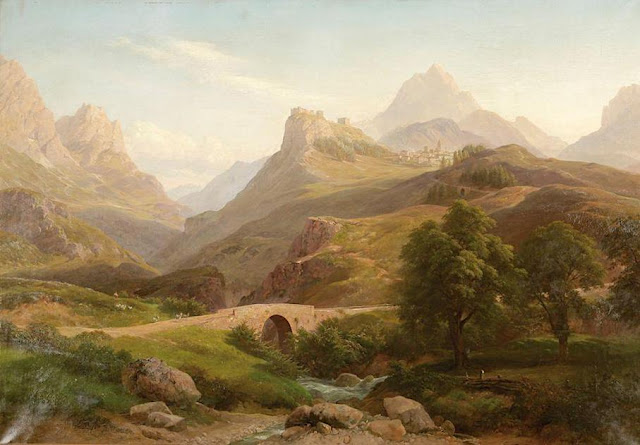
TOFANE PAINTED BY ELIJAH WALTON


https://wanderingvertexes.blogspot.com/2021/03/tofane-painted-by-elijah-walton.html
 
ELIJAH WALTON (1832-1880)
Tofane (3,244 m  - 10,643 ft) 
Italy 

In Tofane as seen from near Cortina d'Ampezzo, Tyrol. 1866 , Birmingham Museum and Art Gallery


The mountain

 Tofane is a mountain group in the Dolomites of northern Italy, west of Cortina d'Ampezzo in the province of Belluno, Veneto. Most of the Tofane lies within Parco naturale delle Dolomiti d'Ampezzo, a nature park. The highest peaks of the Tofane group are Tofana di Mezzo (3,244 m -10,643 ft), Tofana di Dentro (3,238 m-10,623 ft), and Tofana di Rozes (3,225 m -10,581 ft). Tofana di Mezzo is the third highest peak in the Dolomites, after Marmolada (3,343 m -10,968 ft)) and Antelao (3,262 m -10,702 ft). All three peaks were first climbed by Paul Grohmann along with local mountain guides, in 1863 (Tofana di Mezzo - with Francesco Lacedelli), 1864 (Tofana di Rozes - with Francesco Lacedelli, Angelo Dimai and Santo Siorpaes) and 1865 (Tofana di Dentro - with Angelo Dimai).During the First World War, the Tofane was a battlefield of the Italian Front for clashes between the Italian and Austro-Hungarian forces. The front lines went through the mountains.At the 1956 Winter Olympics, Mount Tofane hosted five of the six alpine skiing events. It regularly hosts women's speed events on the World Cup circuit, and is scheduled to host the World Championships in 2021. The route is famous for the Tofana Schuss, where the athletes can reach 130 kilometers per hour.


The artist
The British landscapist, Elijah Walton is best known for his landscapes of mountains in the Alps.
Due to the poorness of his family, without the help of one or two friends he would have been unable to study art, for which his talent was soon exhibited. After passing some years at the art academy in Birmingham, he became at the age of eighteen a student at the Royal Academy Schools in London, where he had already exhibited a picture. There he worked assiduously, drawing from the antique and from life. Nearly ten years later an accidental circumstance revealed to a friend his capabilities in mountain landscape, and in 1860, immediately after his marriage, he went to Switzerland. Thence he proceeded to Egypt, where unhappily his wife died of dysentery near the second cataract. He remained in the east, spending some time in Syria and at Constantinople, till the spring of 1862, when he returned for a short time to London. But for the next five years he was much abroad, working either in the Alps or in Egypt. His sketching tours then became rarer and shorter, though he visited Greece, Norway, and the Alps. At first he resided at Staines, then removed to the neighbourhood of Bromsgrove, living most of the time at the Forelands, near that town. In 1872 his wife died, and the loss permanently affected his health. He died on 25 August 1880 at his residence Beacon Farm, Lickey near Bromsgrove in Worcestershire, leaving three sons. Walton's life was bound up in his art. He worked both in oils and in watercolours, but was more successful with the latter. Most thorough and conscientious in the study both of form and of colour, he delighted especially in mountain scenery and in atmospheric effects, such as an Alpine peak breaking through the mists, or a sunset on the Nile. Few men have equalled him in the truthful rendering of rock structure and mountain form. His pictures were much appreciated by lovers of nature; but as those of small size sold better than larger and more highly finished works, this fostered a tendency to mannerisms.

___________________________________________


2021 - Wandering Vertexes...
by Francis Rousseau

Monday, March 26, 2018

GROSSGLOCKNER BY HEINRICH. C. BERANN


HEINRICH C. BERANN  (1915-1999) 
Grossglockner or Glokner (3,798 m - 12,460ft)
Austria 

 In  Grossglockner poster, 1932

The mountain  
The Grossglockner (or just Glockner) (3,798 m - 12,460 ft) is above the Adriatic, the highest mountain of Austria and the highest mountain in the Alps east of the Brenner Pass. It is part of the larger Glockner Group of the Hohe Tauern range, situated along the main ridge of the Central Eastern Alps and the Alpine divide. The Pasterze, Austria's most extended glacier, lies on the Grossglockner's eastern slope. The characteristically pyramid-shaped peak actually consists of two pinnacles, the Grossglockner and the Kleinglockner (3,770 m -12,370 ft), from German: klein, "small"), separated by a saddle-like formation known as the Glocknerscharte.
The history of the climbs started with French-born natural scientist Belsazar Hacquet, from 1773 professor of anatomy at the Academy of Ljubljana. He travelled the Eastern Alps from 1779 to 1781 and published an itinerary in 1783, describing the Glokner mountain and stating that it had not been climbed yet. He estimated the mountain's height with converted (3,793 m -12,444 ft) and left an engraving illustrating Grossglockner and Pasterze, the first known depiction of the mountain.
Inspired by Hacquet's book and the first ascent of the Mont Blanc in 1786, the Gurk prince-bishop Count Franz Xaver of Salm (1749–1822) together with his vicar general Sigismund Ernst Hohenwart  (1745–1825) and Baron Franz Xaver von Wulfen (1728–1805) started efforts for a Grossglockner expedition. They engaged two peasants from Heiligenblut as mountain guides to do the first explorations for an ascent through the Leitertal valley, which is the side of Grossglockner with the least ice (people feared glaciers in these times). These valiant men, called "Glockners" in the records, did more than they were ordered to do - and probably reached the Kleinglockner summit on 23 July 1799.
One month later the bishop's expedition started: a mountain hut (the first Salm Hut) had been built and the path in the Leitertal valley was prepared so that the bishop could use a horse to reach it. 30 people, among them Salm, Hohenwart and Wulfen, were part of the expedition. They suffered with bad weather and a first effort failed, but on 25 August 1799 Hohenwart and at least four other people, including the two "Glockners", reached - again - the Kleinglockner, where they installed one of the first summit crosses (one of the main goals of the church expedition). Hohenwart's reports did not tell clearly that they had not touched the highest point but Bishop Salm (who had reached the Adlersruhe rock at 3,454 m (11,332 ft)) was informed. Dissatisfied, he invited another, even bigger expedition the next year.
On 28 July 1800, 62 people, among them the pedagogue Franz Michael Vierthaler and the botanist David Heinrich Hoppe, started again into the Leitertal valley. Four peasants and carpenters (the "Glockners" and two others who are not known) did a track in the snow, had installed fixed ropes at some steeper sections up to the end of the Glocknerleitl, and even built a second refuge, called Hohenwarte Hut. The vanguard reached the Kleinglockner peak, however, according to the expedition records by the Dellach priest Franz Joseph Horasch (Orasch), only the four guides and Mathias Hautzendorfer, the local priest of the Rangersdorf parish, were able to cross the Obere Glocknerscharte and climb the Grossglockner summit. Hautzendorfer had to be persuaded to venture the step and administered the last rites in advance.
The two "Glockners" are usually identified as the brothers Joseph (Sepp) and Martin Klotz, however, this surname is not listed in the Heiligenblut parish register. A local peasant named Sepp Hoysen is documented as a member of the second Grossglockner expedition in 1802, and the surveyor Ulrich Schiegg mentioned one Martin Reicher as "Glockner" guide. The peasants and several other members of the expedition (among them Schiegg and his young apprentice Valentin Stanič, who climbed Mt. Watzmann for the first time some weeks later) did the ascent again the next day and finally installed the summit cross and a barometer on the Grossglockner summit.
Bishop Salm undertook two more ascents in 1802 (with Hohenwart reaching the summit) and in 1806, however, he himself never climbed beyond the Adlersruhe rock. The climbing of the Grossglockner was also described by the botanist Josef August Schultes, who explored the massif together with Count Apponyi in 1802. No further ascents were made during the Napoleonic Wars, the huts decayed and were plundered by locals. In the following Vormärz era, however, the mountain became a popular venue for Alpinists like Hermann and Adolf Schlagintweit, who all followed the route of the first ascent.
By the mid 19th century, the developing Alpine tourism began to alter the traditional agriculture economy in the Heiligenblut area. Therefore, the people of Kals tried to lay out a straight ascent from the western side, which however was not reached until Julius von Payer explored the ridge between Glöcknerleitl and Ködnitzkees in 1863. Johann Stüdl had a via ferrata erected along the southwestern ridge the next year and the Stüdlhütte erected at its foot in 1868. Already in 1869, most expeditions to the summit started in Kals. The first winter ascent of the Grossglockner was made on January 2, 1875 by William Adolf Baillie Grohman, a member of the Alpine Club. In 1876 Count Pallavicini and his guide Hans Tribusser undertook the first expedition up the steep glaciated Northeast Face, chopping 2,500 steps into the Pallavicinirinne in an ice climbing master stroke not repeated for 23 years.
In 1879, Count Pallavicini dedicated a new iron summit cross on the occasion of the silver wedding of Emperor Franz Joseph of Austria and Empress Elisabeth; both had visited Heiligenblut and walked to the present-day Franz-Josefs-Höhe viewpoint in 1865. The cross was installed on 2 October 1880. Pallavicini also had the Archduke John Hut erected at the former Adlersruhe resting place of Bishop Salm, today the highest situated mountain hut in Austria. The Austrian Alpine Club built the new Salmhütte and the Glocknerhaus along the alpine route from Heiligenblut.
A first ascent by skiing was made in 1909 and the circumnavigation of the massif soon became a popular ski mountaineering tour. The Grossglockner became Austria's highest mountain, when the South Tyrolean Ortler region had to be ceded to the Kingdom of Italy according to the 1919 Treaty of Saint-Germain, which promoted its reputation as a tourist attraction.

The artist
Heinrich C. Berann, (1915–1999) the father of the modern panorama map, was born into a family of painters and sculptors in Innsbruck, Austria. He taught himself by trial and error. In the years 1930-1933 he attended the arts and design school "Bundeslehranstalt für Malerei" in Innsbruck.
Winning of first prize at a competition for a panorama map created great enthusiasm in him. Using his artistic heritage and new self-discovered techniques he invented a new way of painting landscapes for tourist purposes. The further development of both these panorama maps and his artistic style was influenced by lasting impressions he received during his military service in German Army in Norway and Northern Finland in 1942.
In 1962 he painted Mount Everest for the National Geographic Society, one of his most famous panoramic maps. He worked with Marie Tharp and Bruce C. Heezen to produce maps of the entire ocean floor in 1977.
He later created four panoramas for the United States National Park Service: Yellowstone National Park, North Cascades National Park, Yosemite National Park and finally Mt. McKinley National Park (now Denali). He was very sick when he painted Denali (above) - but he finished it in the age of 81.
In 2000, Tom Patterson of the National Park Service explored ways of digitally creating panoramas like Berann did for the Park Service.

Friday, September 10, 2021

TROLLSLOTTET MOUNTAIN PAINTED BY VEJBJØRN SAND


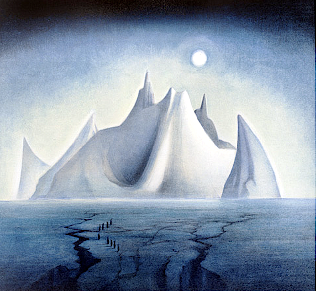
VEJBJØRN SAND (bn. 1966), Trollslottet mountain (2,737 m- 8,930 ft) Antarctica,   In  Trollslottet, 1997, Antarctica


VEJBJØRN SAND (bn. 1966)
Trollslottet mountain (2,737 m- 8,930 ft)
Antarctica

In Trollslottet, 1997, Antarctica  


About this Painting
After an expedition to Antarctica, Queen Maud Land (Independent Norwegian territory in Antarctica) , Vebjørn completed his first public work, The Troll Castle (Trollslottet) which was inspired by the voyage. In collaboration with the team who arranged the opening of the Winter Olympics at Lillehammer in 1994, Vebjørn constructed a “Mini Antarctica” formed by 10 towers surrounding a circle, all reminiscent of Arnesteinen, a mountain shooting out of the ice in the shape of a cathedral. Inside the castle Vebjørn included paintings (as the one above) conceived and executed in Antarctica, stored inside glass boxes to resemble ice. The castle was designed so that visitors could walk inside the space and experience a frigid atmosphere similar to the one Vebjørn did when he painted them. During the first 3 months of its opening in the winter of 1997/98, 180,000 people visited the Troll Castle.


The mountain
Trollslottet Mountain (2,737m - 8,930ft) situated at 71°56′S 7°14′E, is a high ridgelike mountain with several prominent peaks  forming the northwest limit of the Filchner Mountains in Queen Maud Land (Independant Norwegian territory in Antarctica). Plotted from surveys and air photos by Norwegian Antarctic Expedition (1956–60) and named Trollslottet (the troll castle). The Filchner Mountains are a group of mountains 11 km (7 mi) southwest of the Drygalski Mountains, at the western end of the Orvin Mountains of Queen Maud Land, Antarctica. They were discovered by the Third German Antarctic Expedition (1938–1939), led by Capt. Alfred Ritscher, and named for Wilhelm Filchner, leader of the German expedition to the Weddell Sea area in 1911–12. They were remapped from air photos taken by the Sixth Norwegian Antarctic Expedition, 1958–59

The Painter
Vebjørn Sand (born March 11, 1966) is a Norwegian painter and artist. He is known for his paintings as well as his public arts projects, such as the Da Vinci Project, and the Kepler Star monument (Norwegian Peace Star) at Oslo Airport, Gardermoen.
Building off the original Da Vinci bridge in Norway, Vebjørn used Leonardo's philosophy of encompassing all fields of research to use the project to discuss global warming. First he used ice to reinterpret and construct a new bridge during his expedition to Queen Maud Land in Antarctica. After that, in December of 2007, Vebjørn erected a temporary ice bridge to dramatize the melting glaciers of Antarctica due to climate change outside of the United Nations Plaza in New York. During the unveiling at the U.N. Headquarters, Vebjørn said of the bridge in Antarctica,
“Our future lays underneath that ice glacier. So to erect it on that glacier, and that part of Antarctica, (it) must never melt. The one outside the United Nations is intended to melt to show that Antarctica is melting.”
The bridge was unveiled earlier that year two days after nearly 200 nations agreed at the U.N.-led talks in Bali to launch negotiations on a new pact to fight global warming.
In 2009, Vebjørn built another ice bridge in Ilulissat, Greenland (where most icebergs are borne into the sea). Later that year in Copenhagen, as part of the United Nations Climate Change Conference, also known as COP15, Vebjørn constructed yet another ice bridge in front of the Danish Parliament to raise global awareness of climate change.


___________________________________________


2021 - Wandering Vertexes...

by Francis Rousseau 


Monday, August 8, 2016

MOUNT EVEREST PAINTED BY HEINRICH C. BERANN


Pr. HEINRICH C. BERANN  (1915-1999)  
Mount Everest  or Sagarmatha or Chomolunga (8,848 m - 29,029ft) 
China (Tibet) / Nepal  

 In Panoramic maps designed for National Geographic, 1962

The Mountain 
Mount Everest (8,848 m - 29,029ft), also known in Nepal as Sagarmāthā and in Tibet as Chomolungma, is Earth's highest mountain. It is located in the Mahalangur mountain range in Nepal and Tibet. The international border between China (Tibet Autonomous Region) and Nepal runs across Everest's precise summit point. Its massif includes neighbouring peaks Lhotse (8,516 m -27,940 ft); Nuptse (7,855 m -25,771 ft) and Changtse (7,580 m -24,870 ft).
In 1856, the Great Trigonometrical Survey of India established the first published height of Everest, then known as Peak XV, at (8,840 m -29,002 ft). The current official height of (8,848 m -29,029 ft) as recognised by China and Nepal was established by a 1955 Indian survey and subsequently confirmed by a Chinese survey in 1975. In 1865, Everest was given its official English name by the Royal Geographical Society upon a recommendation by Andrew Waugh, the British Surveyor General of India. As there appeared to be several different local names, Waugh chose to name the mountain after his predecessor in the post, Sir George Everest, despite George Everest's objections.
Mount Everest attracts many climbers, some of them highly experienced mountaineers. There are two main climbing routes: one approaching the summit from the southeast in Nepal (known as the standard route) and the other from the north in Tibet. While not posing substantial technical climbing challenges on the standard route, Everest presents dangers such as altitude sickness, weather, wind as well as significant objective hazards from avalanches and the Khumbu Icefall. As of 2016, there are well over 200 corpses still on the mountain, with some of them even serving as landmarks.
The first recorded efforts to reach Everest's summit were made by British mountaineers. With Nepal not allowing foreigners into the country at the time, the British made several attempts on the north ridge route from the Tibetan side. After the first reconnaissance expedition by the British in 1921 reached 7,000 m - 22,970 ft) on the North Col, the 1922 expedition pushed the North ridge route up to 8,320 m - 27,300 ft) marking the first time a human had climbed above 8,000 m - 26,247 ft). Tragedy struck on the descent from the North col when seven porters were killed in an avalanche. The 1924 expedition resulted in the greatest mystery on Everest to this day: George Mallory and Andrew Irvine made a final summit attempt on 8 June but never returned, sparking debate as to whether they were the first to reach the top. They had been spotted high on the mountain that day but disappeared in the clouds, never to be seen again, until Mallory's body was found in 1999 at 8,155 m (26,755 ft) on the North face. Tenzing Norgay and Edmund Hillary made the first official ascent of Everest in 1953 using the southeast ridge route. Tenzing had reached 8,595 m - 28,199 ft) the previous year as a member of the 1952 Swiss expedition. The Chinese mountaineering team of Wang Fuzhou, Gonpo and Qu Yinhua made the first reported ascent of the peak from the North Ridge on 25 May 1960.
Mount Everest is one of the Seven Summit, which includes the highest mountains of each of the seven  continents. Summiting all of them is regarded as a mountaineering  challenge, first achieved on April 30, 1985 by Richard Bass. 
The 7 summits (which are obviously 8 !)... are :  
Mount Everest (8,848 m), Aconcagua (6,961m), Mt Denali or Mc Kinley (6,194 m), Kilimandjaro (5,895 m), Mt Elbrus (5,642 m), Vinson  Massif (4,892 m), Mt Blanc (4,807 m) and Mount Kosciuszko  (2,228 m) in Australia.
Financial cost of guided climbs
Going with a "celebrity guide", usually a well-known mountaineer typically with decades of climbing experience and perhaps multiple Everest summits, can cost over £100,000 as of 2015. On the other hand, a limited support service, offering only some meals at base camp and bureaucratic overhead like a permit, can be as little as 7,000 USD.[ There are issues with the management of guiding firms in Nepal, and one Canadian woman was left begging for help when her guide firm, which she had paid perhaps 40,000 dollars to, couldn't stop her from dying in 2012. She ran out of bottled oxygen after climbing for 27 hours straight. Despite decades of concern over inexperienced climbers, neither she nor the guide firm had summited Everest before. The communist-controlled Tibetan/Chinese side does not offer much reprieve from the chaos, with it being described as "out of control" due to multiple reports of thefts, threats, etc.  By 2015, Nepal was considering requiring that summiters have some experience and wanted to make the mountain safer, and especially increase revenue. One barrier to this is that low-budget firms make money not taking inexperienced climbers to the summit. (subscription required) Those turned away by western firms can often find another firm willing to take them for a price—that they return home soon after arriving after base camp, or part way up the mountain. Whereas a western firm will convince those they deem incapable to turn back, other firms simply give people the freedom to choose.[331] Mountain managers can be left with difficult choices, sometimes balancing greed with the safety of tourists; as one bureaucrat for the extremely popular Mont Blanc put it, "Climbing the Mont Blanc is a matter for serious mountaineers. It isn't a trek or a playground to get a mention in the Guinness World Records" Mount Blanc may be an indicator of how extreme Everest can go, a mountain that dwarfs Everest in popularity— and fatalities, with tens of thousands, not hundreds summiting a commensurate increase in fatalities, with over a hundred dying each year. The battle for safety is a struggle there as in the Himalaya's, with another official jokingly noting they want to send Pamela Anderson to rescue tourists (perhaps a nod to her role as a life-guard on the U.S. television show Baywatch).
In 2016 the increased use of helicopters was noted for increased efficiency and for hauling materiel over the deadly Khumbu icefall. In particular it was noted that flights saved icefall porters 80 trips but still increased commercial activity at Everest. After many Nepal died in the icefall in 2014, the government had wanted helicopters to handle more transportation to Camp 1 but this was not possible because of the 2015 deaths and earthquake closing the mountain, so the this was implemented in 2016 (helicopters did prove instrumental in rescuing many people in 2015 though). That summer Bell tested the 412EPI, which conducted a series of tests including hovering at 18,000 feet and flying as high as 20,000 feet altitude near Mount Everest.

The artist
Heinrich C. Berann, (1915–1999) the father of the modern panorama map, was born into a family of painters and sculptors in Innsbruck, Austria. He taught himself by trial and error. In the years 1930-1933 he attended the arts and design school "Bundeslehranstalt für Malerei" in Innsbruck.
Winning of first prize at a competition for a panorama map created great enthusiasm in him. Using his artistic heritage and new self-discovered techniques he invented a new way of painting landscapes for tourist purposes. The further development of both these panorama maps and his artistic style was influenced by lasting impressions he received during his military service in German Army in Norway and Northern Finland in 1942.
In 1962 he painted Mount Everest for the National Geographic Society, one of his most famous panoramic maps (see picture above)
He worked with Marie Tharp and Bruce C. Heezen to produce maps of the entire ocean floor in 1977.
He later created four panoramas for the United States National Park Service: Yellowstone National Park, North Cascades National Park, Yosemite National Park and finally Mt. McKinley National Park (now Denali). He was very sick when he painted Denali - but he finished it in the age of 81.
In 2000, Tom Patterson of the National Park Service explored ways of digitally creating panoramas like Berann did for the Park Service.
References
-  H.C. Berann dedicated website : The World of H.C. Berann

Thursday, January 12, 2023

LES ILES LOFOTEN PEINTES PAR ANNA-KATARINA BOBERG


ANNA-KATARINA BOBERG (1864-1935) Le Higravstinden / Iles Lofoten (1,148 m- 3766 ft) Norvège  In " Northern Lights. Study from North Norway" (c. 1901-09) huile sur toile 46 x 55 cm. Nationalmuseum, Stockholm

ANNA-KATARINA BOBERG (1864-1935)
Le Higravstinden / Iles Lofoten (1,148 m- 3766 ft)
Norvège

In " Northern Lights. Study from North Norway" (c. 1901-09) huile sur toile 46 x 55 cm. Nationalmuseum, Stockholm 

 
La montagne
Le Higravstinden (1, 148 m- 3,766 ft) )est le plus haut sommet de l'archipel des Lofoten appartenant à la Norvège. Il se situe sur l'île d'Austvågøya. Les îles Lofoten se situent au large de Bodø, au nord du cercle polaire, entre la mer de Norvège et le Vestfjord, bras de mer poissonneux qui les sépare du continent. Les Lofoten sont caractérisées par des montagnes et des pics, des baies protégées et des côtes découpées. Si le nord de l'archipel fournit des étendues herbeuses relativement importantes, le relief est de plus en plus escarpé au fur et à mesure que l'on descend vers le sud, laissant place à une forme caractéristique d'« Alpes dans la mer », où seule une étroite bande côtière est assez habitable. À Svolvær, le jour polaire se produit du 25 mai au 17 juillet, et la nuit polaire du 4 décembre au 7 janvier. À Leknes, le soleil ne descend pas sous l'horizon entre le 26 mai et le 17 juillet. La nuit est ininterrompue du 9 décembre au 4 janvier. Des aerores boréales et des phénomènes lumineux inhabituels sous d'autres latitude terrestres peuvent alors être observés, comme c'est le cas sur cette toile de Anna Katarina BIoberg


L'artiste
Anna Katarina Boberg (1864-1935), suédoise, mariée à l'architecte Ferdinand Boberg est née Anna Scholander, fille de l'architecte Fredrik Wilhelm Scholander. Elle est la sixième de sept enfants. Elle étudie le français et, durant une courte période, étudie la peinture à l'Académie Julian à Paris. En 1905, Anna Boberg rencontre Margaret de Connaught, princesse héritière de Suède, qui était aussi peintre. Un rencontre et amitié qui mènera les deux femmes chevalier en bandouliere dans dans la région de Stockholm ou elles peignirent ensemble de nombreux paysages. Mais le grand œuvre d'Anna Boberg fut le sans conteste sa peinture des paysages des Iles Lofoten qu'elle découvrit pour la première fois en 1901 et et qu'elle ne cessa de peindre pendant les 33 années suivantes. Les glaciers, l'océan, le soleil de minuit et ses lumières furent d'inépuisables sources d'inspiration pour elle. En 1925, elle s'installe avec son mari à Paris où ils resteront quatre années avant de retourner à Stockholm. Ils vvrrons désormais dans la villa Tin Grand à Södermalm jusqu’à la mort d'Anna Boberg en 1935. Anna Boberg fut une artiste polyvalente. Elle peignit aussi bien des tableaux de montagnes que des panneaux décoratifs,pour les salles à manger des grands hôtels. Elle a également conçu la céramique « Vase Peacock » pour Rörstrand en 1897. Elle a aussi travaillé le verre et le tissu avec un égal bonheur. 
 

 _________________________________________

2023 - Wandering Vertexes ....
            Errant au-dessus des Sommets Silencieux...
            Un blog de Francis Rousseau