google.com, pub-0288379932320714, DIRECT, f08c47fec0942fa0 GRAVIR LES MONTAGNES... EN PEINTURE

Saturday, October 22, 2022

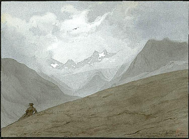
CIRQUE DE BARROSA SKETCHED BY FRANZ SCHRADER


FRANZ SCHRADER (1844-1924), The Cirque de Barrosa (1,745m - 5,725 ft) France- Spain border (Pyrénées)  In "Le Cirque de Barrosa", watercolor


FRANZ SCHRADER (1844-1924),
The Cirque de Barrosa (1,745m - 5,725 ft)
France- Spain border (Pyrénées)

In "Le Cirque de Barrosa", watercolor


The painter
Jean-Daniel-François Schrader, better known as Franz Schrader, was a French mountaineer, geographer, cartographer and landscape painter. He made an important contribution to the mapping of the Pyrenees and was highly considered among the pyreneists.
He is the son of Prussian Ferdinand Schrader from Magdeburg, who emigrated to Bordeaux, and of Marie-Louise Ducos, cousin of geographers Élisée and Onésime Reclus. He shows a talent for drawing from an early age. In 1866, while staying with his friend Léonce Lourde-Rocheblave in Pau, he has a sort of revelation at the "spectacle grandiose de la barrière montagneuse des Pyrenées ".
His vocation strengthens when reading stories by Ramond de Carbonnières (1755-1827) (Les Voyages au Mont-Perdu) and by Henry Russell (1834-1909) (Les Grandes Ascensions des Pyrénées, guide d'une mer à l'autre).
While devoting the main part of his leisure to long hikes in the mountains, during which he gathers thousands of observations for his topographical records, he still finds time to paint numerous panoramas of the Pyrenees as well as the Alps which he also studies, and to acquire a solid formation in topography.
To facilitate topographical work in rugged terrain, he develops the orograph in 1873. His first great cartographic work, in 1874, is the map of the massif of Gavarnie-Mont-Perdu at a scale of 1:40 000, for which he collects the measurements with the participation of Lourde-Rocheblave from nearby Pau. That map triggers such a sensation that it is included in the annual Mémoires of the Société des Sciences Physiques et Naturelles de Bordeaux with an explanatory text the following year. The Club alpin français directory follows with the publication of an enthusiastic review, describing Schrader as qualified for "first rank topographer in a glorious master stroke". In 1876 he takes part in the creation of the Bordeaux section of the Club Alpin Français, becoming its first president.
In 1877 he travels to Paris with a recommendation from his cousins Élisée and Onésime Reclus. There, having met Émile Templier, nephew and collaborator of Louis Hachette, and Adolphe Joanne, president of the Parisian section of the Club Alpin Français, he is employed as a geographer by Librairie Hachette and is now able to practice his passion in the scope of his profession. He also gives geography lessons at the School of Anthropology and also becomes editor of the French Alpine Club directory
In 1927, three years after his death, his remains are transferred to a tomb on a slope of the Circus of Gavarnie (French Pyrenees). 

The mountain
The Cirque de Barrosa (1745m - (Circo de Barrosa in Spanish) is a glacial cirque located in the center of the Pyrenees chain, in Spain, in the comarca of Sobrarbe (province of Huesca, autonomous community of Aragon). Part of its ridge line forms the border with France.
It is a beautiful mountain circus, attractive for mountaineers, but it is distinguished by its geological structure in two floors, the upper floor being part of an overlap, and by the remains of an old mule track which crosses it from side to side. However, these two singularities are intimately linked since this path has been laid out on a natural cornice which runs, in the cliffs, at the limit between the two floors, which gives its route a great interest from a geological point of view.
In addition, the Cirque de Barrosa provides the opportunity to take an interest in several stories: those of mining in the region of the cirque, to which this path is linked; that of human relations between France and the Bielsa valley, via this path or neighboring passes; that of an episode of the Spanish Civil War, of which the Bielsa Valley was the scene; and that of Pyreneism, whose pioneers discovered the circus at the end of the 19th century.

_______________________________

2022 - Wandering Vertexes...
by Francis Rousseau

Wednesday, October 19, 2022

ALBORZ RANGE PHOTOGRAPHED BY FRÉDÉRIC GADMER IN 1927


FRÉDÉRIC GADMER (1878-1954) Alborz range (5,610.0 m -18,405.5 ft) Iran  In  "Vallée dans La chaine de l'Elbourz vue de Téhéran ", Iran, Autochrome Lumiere, 1927,   Courtesy Collection Albert Kahn, Paris.


FRÉDÉRIC GADMER (1878-1954)
Alborz range (5,610.0 m -18,405.5 ft)
Iran

In  "Vallée dans La chaine de l'Elbourz vue de Téhéran ", Iran, Autochrome Lumiere, 1927, 

Courtesy Collection Albert Kahn, Paris.


The photographer
Frédéric Georges Gadmer was born in 1878 in France into a Protestant family; his father, Leon, son of Swiss émigré, was confectioner. Before World War II, he follows his family in Paris and works as a photographer for the house Vitry, located Quai de la Rapée. As an heliogravure company, it performs work for the sciences and the arts, travel and education. In 1898 Gadmer completed his military service as a secretary to the staff then recalled in 1914 at the time of mobilization. In 1915, he joined the newly created "Photographic Section of the Army" and carried pictures on the front, in the Dardanelles, with General Gouraud, then in Cameroon. In 1919, at age 41, he was hired as a photographer by Albert Khan for his project called "Archives of the Planet". He finds there his comrades of "the film and photographic section of the army" Paul Castelnau and Fernand Cuville. Soon as he arrived, he made reports in Syria, Lebanon, Turkey and Palestine. It was the first to make a color portrait of Mustafa Kemal, leader of the Young Turks. In 1921, he returned to the Levant with Jean Brunhes, the scientific director of the Archives of the Planet. The same year, he attended General Gouraud, appointed High Commissioner in Syria. Operator and prolific photographer, specializing in distant lands and landscapes, it covers Iraq, Persia, Afghanistan, Algeria and Tunisia. In 1930, he accompanied Father Francis Aupiais in Dahomey. He also works in Europe. In 1931, at the request of Marechal Lyautey, he photographies the Colonial Exhibition. It is one of the last person to leave the "Archives of the Planet" threatened by the Albert Kahn's bankruptcy in 1932. He then worked at the famous french newspaper L'Illustration and carries postcards for Yvon. He died in Paris, unmarried, in 1954.


The mountains
The Alborz ( Persian: البرز) range, also spelled as Alburz, Elburz or Elborz, is a mountain range in northern Iran that stretches from the border of Azerbaijan along the western and entire southern coast of the Caspian Sea and finally runs northeast and merges into the smaller Aladagh Mountains and borders in the northeast on the parallel mountain ridge Kopet Dag in the northern parts of Khorasan. All these mountains are part of the much larger Alpide belt. This mountain range is divided into the Western, Central, and Eastern Alborz Mountains. The Western Alborz Range (usually called the Talysh) runs south-southeastward almost along the western coast of the Caspian Sea. The Central Alborz (the Alborz Mountains in the strictest sense) runs from west to east along the entire southern coast of the Caspian Sea, while the Eastern Alborz Range runs in a northeasterly direction, toward the northern parts of the Khorasan region, southeast of the Caspian Sea. Mount Damavand, the highest mountain in Iran measuring 5,610.0 m (18,405.5 ft), is located in the Central Alborz Mountains.


About the "Autochrome Lumière" Photos
The autochrome is a photographic reproduction of process colors patented December 17, 1903 by Auguste and Louis Lumière french brothers. This is the first industrial technique of photography colors, it produces positive images on glass plates. It was used between 1907 and 1932 approximately an particularly in many pictures of the World War I. A important number of photographs of mountains and landscapes around the world was made with this technique, particularly in the for the Project "The archives of the planet" by Albert Kahn.
_______________________________

2022 - Wandering Vertexes...
by Francis Rousseau

Sunday, October 16, 2022

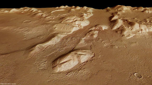
PHLEGRA MONTES PHOTOGRAPHED BY ESA MARS EXPRESS MISSION


MARS EXPRESS MISSION ( 2004-2022) Phlegra Montes (1,4km - 870 mi) Mars (Solar system)

ESA MARS EXPRESS MISSION ( 2004-2022)
Phlegra Montes (1,4km - 870 mi)
Mars (Solar system)


About that image
The High-Resolution Stereo Camera on ESA’s Mars Express collected the data for these images on 1 June 2011 during orbit 9465. This perspective view has been calculated from the Digital Terrain Model derived from the stereo channels.
Courtesey ESA/DLR/FU Berlin (G. Neukum),CC BY-SA 3.0 IGO


The mountains
The Phlegra Montes are a system of eroded Hesperian–Noachian-aged massifs and knobby terrain in the mid-latitudes of the northern lowlands of Mars, extending northwards from the Elysium Rise towards Vastitas Borealis for nearly 1,400 km (870 mi). The mountain ranges separate the large plains provinces of Utopia Planitia (west) and Amazonis Planitia (east), and were named in the 1970s after a classical albedo feature. The massif terrains are flanked by numerous parallel wrinkle ridges known as the Phlegra Dorsa. The mountain ranges were first mapped against imagery taken during NASA's Viking program in the 1970s, and the area is thought to have been uplifted due to regional-scale compressive stresses caused by the contemporary formations of the Elysium and Tharsis volcanic provinces. Recent research has unveiled the presence of extensive thrust faulting bounding the massif terrains. Since the 2010s, researchers have proposed the presence of a significant late Amazonian glaciation event along the Martian northern mid-latitudes, citing the presence of lineated valley fills, lobate debris aprons, and concentric crater fills. The presence of ring mold craters imply that significant stores of water ice may continue to persist in these terrains. Features interpreted as eskers have been observed in the southern Phlegra Montes. However, whether this glaciation was localized or of regional scale remains subject to debate in the scientific community.

About the mission
Mars Express is a space exploration mission being conducted by the European Space Agency (ESA). The Mars Express mission is exploring the planet Mars, and is the first planetary mission attempted by the agency. "Express" originally referred to the speed and efficiency with which the spacecraft was designed and built.However, "Express" also describes the spacecraft's relatively short interplanetary voyage, a result of being launched when the orbits of Earth and Mars brought them closer than they had been in about 60,000 years. Mars Express consists of two parts, the Mars Express Orbiter and Beagle 2, a lander designed to perform exobiology and geochemistry research. Although the lander failed to fully deploy after it landed on the Martian surface, the orbiter has been successfully performing scientific measurements since early 2004, namely, high-resolution imaging and mineralogical mapping of the surface, radar sounding of the subsurface structure down to the permafrost, precise determination of the atmospheric circulation and composition, and study of the interaction of the atmosphere with the interplanetary medium. Due to the valuable science return and the highly flexible mission profile, Mars Express has been granted several mission extensions. The latest was approved on 1 October 2020 and runs until 31 December 2022. Some of the instruments on the orbiter, including the camera systems and some spectrometers, reuse designs from the failed launch of the Russian Mars 96 mission in 1996 (European countries had provided much of the instrumentation and financing for that unsuccessful mission). The design of Mars Express is based on ESA's Rosetta mission, on which a considerable sum was spent on development. The same design was also used for ESA's Venus Express mission in order to increase reliability and reduce development cost and time. Because of these redesigns and repurposings, the total cost of the project was about $345 million- less than half of comparable U.S. missions. Arriving at Mars in 2003, 18 years, 9 months and 10 days ago (and counting), it is the second longest surviving, continually active spacecraft in orbit around a planet other than Earth, behind only NASA's still active 2001 Mars Odyssey.

______________________________
2022- Wandering Vertexes
A blog by Francis Rousseau

Thursday, October 13, 2022

MOUNT ZEIL / URLATHERRKE PAINTED BY ALBERT NAMATJIRA


ALBERT NAMATJIRA (1902-1959) Mount Zeil ot Urlatherrke (1,531 m - 5,023 ft) Australia  In "Glen Helen", watercolor, 1930


ALBERT NAMATJIRA (1902-1959)
Mount Zeil ot Urlatherrke (1,531 m - 5,023 ft)
Australia

In "Glen Helen", watercolor, 1930


The mountain 
Mount Zeil (1,531m - 5,023ft)  Urlatherrke  in aboriginal naming,  is a mountain situated in the western MacDonnell Ranges in Australia's Northern Territory. It is the highest peak in the Northern Territory, and the highest peak on the Australian mainland west of the Great Dividing Range. The others peaks of MacDonell Ranges are:  Mount Liebig (1,524m - 5,000 ft), Mount Edward  (1,423m - 4,669 ft), Mount Giles (1,389m - 4,557 ft) and Mount Sonder (1,380m - 4,530 ft). 
It is believed that Mount Zeil was named during or following Ernest Giles' 1872 expedition, probably after Count Zeil, who had recently distinguished himself with geographic explorations in Spitzbergen; a footnote in Giles' published journal implies that the naming was instigated by his benefactor, Baron Ferdinand von Mueller.
The MacDonnell Ranges, a mountain range and an interim Australian bioregion, is located in the Northern Territory, comprising 3,929,444 hectares (9,709,870 acres). The range is a 644 km (400 mi) long series of mountains located in the centre of Australia, and consist of parallel ridges running to the east and west of Alice Springs. The mountain range contains many spectacular gaps and gorges as well as areas of aboriginal significance. The ranges were named after Sir Richard MacDonnell (the Governor of South Australia at the time) by John McDouall Stuart, whose 1860 expedition reached them in April of that year. The Horn Expedition investigated the ranges as part of the scientific expedition into central Australia. Other explorers of the range included David Lindsay and John Ross.The headwaters of the Todd, Finke and Sandover rivers form in the MacDonnell Ranges. The range is crossed by the Australian Overland Telegraph Line and the Stuart Highway. Part of the Central Ranges xeric scrub ecoregion of dry scrubby grassland  the ranges are home to a large number of endemic species including the Centralian Tree Frog. This is mostly due to the micro climates that are found around the cold rock pools.
The MacDonnell Ranges were often depicted in the paintings of Albert Namatjira.
 
The Painter
Albert Namatjira  born Elea Namatjira, was a Western Arrernte-speaking Aboriginal artist from the MacDonnell Ranges in Central Australia. As a pioneer of contemporary Indigenous Australian art, he was the most famous Indigenous Australian of his generation.
Born and raised at the Hermannsburg Lutheran Mission outside Alice Springs, Namatjira showed interest in art from an early age, but it was not until 1934 (aged 32), under the tutelage of Rex Battarbee, that he began to paint seriously. Namatjira's richly detailed, Western art-influenced watercolours of the outback departed significantly from the abstract designs and symbols of traditional Aboriginal art, and inspired the Hermannsburg School of painting. He became a household name in Australia—indeed, reproductions of his works hung in many homes throughout the nation—and he was publicly regarded as a model Aborigine who had succeeded in mainstream society.
Although not the first Aboriginal artist to work in a European style, Albert Namatjira is certainly the most famous. Ghost gums with luminous white trunks, palm-filled gorges and red mountain ranges turning purple at dusk are the hallmarks of the Hermannsburg school. Hermannsburg Mission was established by Lutheran missionaries in 1877 on the banks of the Finke River, west of Mparntwe (Alice Springs). Namatjira learnt watercolour technique from the artist, Rex Battarbee.
 
______________________________
2022- Wandering Vertexes
Un blog de Francis Rousseau

Monday, October 10, 2022

THE FIZTROY (?) PAINTED BY RHOD WULFARS


RHOD WULFARS (bn. 1979), The Fitz Roy / Cerro Chalten (3,405 m- 11, 171 ft) Chile - Argentina border


RHOD WULFARS (bn. 1979),
The Fitz Roy / Cerro Chalten (3,405 m- 11, 171 ft)
Chile - Argentina border

About this painting
The painter wrote: “It is not a real mountain. Most of my paintings are born from the combination of the imagination and the hours spent looking, walking and smelling them. I call them "Twins" because they are similar to those reliefs of the Argentinian Andean Coridilla called "acarreos", which are long slopes of very popular loose rock that can be easily viewed. very frequently observed. This painting is therefore that of an unknown mountain, dreamt up which sums up several, and which came out of my unconscious one afternoon when the brush gave it life in a mysterious way without my being able to explain it. "
The artist
Rhod Wulfars is a contemporary mountain painter using mainly acrylic technique for his paintings.
He was born in 1979 in Mendoza (Argentina). In his website he wrote: "I have spent my whole life by the mountains. On day I started to paint them". Using, in the manner of Nicolas de Staël, a style always beetween abstract and figurative, his very strong and very moving paintings described perfectly the majesty and the spectacular contents of the peaks he paints. Rhod Wulfars makes a surprising use of acrylic medium, in thick paste as one could do with oil paint. He used to named his works only bu numbers, and series letters, but sometime he writes the name of the peaks ans makes it more easy to identify. Other works by this artist on his website : rhodwulfars.wixsite.com/rhodwulfars/


The mountain
Fitz Roy / Cerro Chalten (3,405m- 11, 171 ft) is a mountain located near El Chaltèn village, in the Southern Patagonian Ice Field in Patagonia, on the border between Argentina and Chile. First climbed in 1952 by French alpinists Lionel Terray and Guido Magnone, " The Fitz Roy " remains among the most technically challenging mountains for mountaineers on Earth. Mount Fitz Roy is the basis for the Patagonia clothing logo following Yvon Chouinard's ascent and subsequent film in 1968.
Argentine explorer Francisco Moreno first saw the mountain on 2 March 1877. He named it Fitz Roy, in honour of Robert FitzRoy, who, as captain of the HMS Beagle had travelled up the Santa Cruz River in 1834 and charted large parts of the Patagonian coast.
Cerro is a Spanish word meaning mountain, while Chaltèn comes from a Tehuelche (Aonikenk) word meaning "smoking mountain", due to a cloud that usually forms around the mountain's peak. Fitz Roy, however, was only one of a number of peaks the Tehuelche called Chaltèn.
It has been agreed by Argentina and Chile that their international border detours eastwards to pass over the main summit, but a large part of the border to the south of the summit, as far as Cerro Murallуn, remains undefined.

______________________________
2022- Wandering Vertexes
Un blog de Francis Rousseau

Friday, October 7, 2022

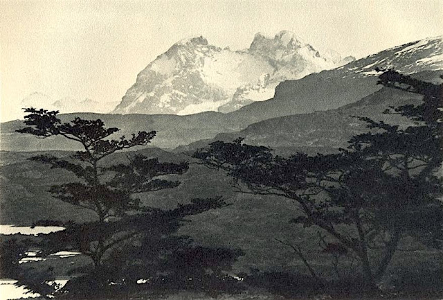
CERRO BALMACEDA PHOTOGRAPHED BY ROBERT GERSTMANN


ROBERT GERSTMANN (1896-1960), Cerro Balmaceda  (2,035 m  - 6,677 ft) Chile  In "Cerro Balmaceda",  glass plate, 1932, University of Antofagasta.

ROBERT GERSTMANN (1896-1960)
Cerro Balmaceda  (2,035 m  - 6,677 ft)
Chile

In "Cerro Balmaceda",  glass plate, 1932, University of Antofagasta.


The photographer
Robert Gerstmann was a photographer very famous in South America. Gerstmann was a Vienna born electrical engineer who, as a young man, developed an interest in photography. In 1924, he immigrated to Chile and from there traveled to Bolivia, where he made some 5000 photographs, a selection of which appear as photogravures in his Bolivia, 150 Grabados en Cobre (1928), which was reissued in 1996 by the Fundación Quipus in La Paz. Gerstmann ranged far, photographing the altiplano from La Paz south to the Argentine border, west to the Chilean border, and east to the Yungas, Cochabamba, Santa Cruz, and the lowlands along the Ríos Beni and Mamoré. Only Tarija and the Chaco escaped his lens. Five of his photographs illustrate Stewart E. McMillan's "The Heart of Aymara Land" National Geographic Magazine (February 1927), and several appear in Gustavo-Adolfo Otero's Bolivia (Guía Sinóptica) 1929. Gerstmann settled in Santiago in 1929. He published other photo albums, including Chile: 280 grabados en cobre (1932), Colombia: 200 grabados en cobre (1951), and Chile en 110 cuadros (1960?), and dabbled in film-making in Bolivia. He is thought to have died in Santiago ca. 1960. Several thousand of his glass plates are said to be at a university in Antofagasta.


The mountain
Cerro Balmaceda (2,035 m - 6,677 ft) is a heavily glaciated mountain located in the Magallanes Region of Chile. It stands at the head of Última Esperanza Sound, in the south portion of Bernardo O'Higgins National Park and near the mouth of the Serrano River. The glaciers Balmaceda and Serrano mantle the slopes of the mount.  In its vicinity is Torres del Paine National Park.
_______________________________
2022 - Wandering Vertexes...
by Francis Rousseau

Tuesday, October 4, 2022

WUDANGSHAN / 武当山 PAINTED BY JEAN-BAPTISTE NÉE


JEAN-BAPTISTE NÉE (b.1986) Wudangshan / 武当山 ( 1,610m - 5, 282 ft) China (Hubei)   In "Wudangshan (X)," lavis, 2018, 28x38cm

 JEAN-BAPTISTE NÉE (b.1986)
Wudangshan / 武当山 ( 1,610m - 5, 282 ft)
China (Hubei)

In "Wudangshan (X)," lavis, 2018, 28 x 38cm, 
Collection privée ©Jean-Baptiste Née
@jeanbaptiste.nee

The artist
Jean-Baptiste Née, born in 1986. is a french painter, scenographer and visual artist, graduated from Arts-Décoratifs of Paris in 2012. Jean-Baptiste Née works in the mountains and high mountains, always in situ, in direct confrontation with the movements of the earth and water and wind. He gives a growing place for the action of the elements on the work in progress (rain, snow, frost, etc.). He established his "large workshop" in the Swiss Alps or in the Vercors massif - especially in winter -, as well as during long hikes in the Italian Alps. In the winter of 2018, he worked in the massifs of Wudangshan and Lushan, in China, (see above) and became interested in the Taoist notion of "Sky" (t’ien 天).Since 2016, Jean-Baptiste Née exhibits regularly in galleries in France and Switzerland. His workshop is in Montreuil, France.

The mountains
The Wudang Mountains /武当山 (1,610m - consist of a mountain range in the northwestern part of Hubei, China, just south of Shiyan. They are home to a famous complex of Taoist temples and monasteries associated with the Lord of the North, Xuantian Shangdi. The Wudang Mountains are renowned for the practice of Tai chi and Taoism as the Taoist counterpart to the Shaolin Monastery, which is affiliated with Chinese Chán Buddhism. The Wudang Mountains are one of the "Four Sacred Mountains of Taoism" in China, an important destination for Taoist pilgrimages. The monasteries such as the Wudang Garden were made a UNESCO World Heritage Site in 1994 because of their religious significance and architectural achievement.  On Chinese maps, the name "Wudangshan" is applied both to the entire mountain range (which runs east-west along the southern edge of the Han River, crossing several county-level divisions of Shiyan), and to the group of peaks located within Wudangshan subdistrict of Danjiangkou, Shiyan. It is the latter specific area which is known as a Taoist center.  ome consider the Wudang Mountains to be a "branch" of the Daba Mountains range, which is a major mountain system in western Hubei, Shaanxi, Chongqing and Sichuan.
____________________________________

2022- Wandering Vertexes.
A blog by Francis Rousseau

Saturday, October 1, 2022

SAN MINIATO HILLS PAINTED BY JOHN HENRY TWACHTMAN


JOHN HENRY TWACHTMAN (1853-1902) San Miniato Hills (140m) Italy (Tuscanny)  In San Miniato Hills (140m) 1892, oil on painting, 22 x 48cm, Private collection, New York
 
JOHN HENRY TWACHTMAN (1853-1902)
San Miniato Hills (140m - 459 ft))
Italy (Tuscanny)

In San Miniato Hills, 1892, oil on painting, 22 x 48cm, Private collection, New York


The hills
San Miniato sits at an historically strategic location atop three small hills (140m - 459 ft) where it dominates the lower Arno valley, between the valleys of Egola and Elsa rivers. Miniato is a town in the province of Pisa, in the region of Tuscany, ItalyIt used to carry the additional sobriquet al Tedesco ("to the German") to distinguish it from the convent of San Miniato al Monte in Florence, which is about 40 kilometres (25 mi) to the northeast. In medieval times, San Miniato was on the via Francigena, which was the main connecting route between northern Europe and Rome. It also sits at the intersection of the Florence-Pisa and the Lucca-Siena roads. Over the centuries San Miniato was therefore exposed to a constant flow of friendly and hostile armies, traders in all manner of goods and services, and other travelers from near and far. Archaeological evidence indicates that the site of the city and surrounding area has been settled since at least the paleolithic era. It would have been well known to the Etruscans, and certainly to the Romans, for whom it was a military post called "Quarto".

The painter
John Henry Twachtman was an American painter best known for his impressionist landscapes, though his painting style varied widely through his career. Art historians consider Twachtman's style of American Impressionism to be among the more personal and experimental of his generation. Twachtman was born in Cincinnati, Ohio and received his first art training there, including studying under Frank Duveneck. Like some white artists of means and European heritage of the era, Twachtman then proceeded to Europe to further his education. He enrolled in the Academy of Fine Arts in Munich in 1875 and visited Venice with Duveneck and William Merritt Chase in 1878. His landscapes from this time exhibit the loosely brushed, shadowy technique taught at Munich. Twachtman also learned etching, and sometimes carried etching plates with him that he could use to spontaneously record a scene. After a brief return to America, Twachtman studied from 1883 to 1885 at the Académie Julian in Paris, and his paintings dramatically shifted towards a soft, gray and green tonalist style. During this time he painted what some art historians consider to be his greatest masterpieces, including Arques-la-Bataille, in the collection of the Metropolitan Museum of Art in New York, and Springtime, in the collection of the Cincinnati Art Museum. In 1886 he returned to America. In 1890, he bought a farm in Greenwich. He often painted and exhibited with fellow artist Julian Alden Weir, and spent considerable time at the art colony in Cos Cob. His presence was vital to the colony. In addition to his oil paintings, Twachtman produced drawings in pastel. He taught painting at the Art Students League from 1889 until his death in 1902. Twachtman was close friends with Julian Alden Weir and the two often painted together. In Connecticut his painting style shifted again, this time to a highly personal impressionist technique. Twachtman painted many landscapes of his farm and garden in Greenwich, often depicting the snow-covered landscape. He executed dozens of paintings of a small waterfall on his property, capturing the scene in different seasons and times of day. In the summers of 1900–1902, Twachtman visited Gloucester, Massachusetts, another center of artistic activity in the era, and produced a series of vibrant scenes that anticipated a more modernist style yet to gain prominence in American art. Twachtman died suddenly in Gloucester of a brain aneurysm, aged 49. Today, his works are in many museum collections including the Metropolitan Museum of Art, New York; the National Gallery of Art, Washington, D.C.; and the Museum of Fine Arts, Boston.
___________________________________________
2022 - Wandering Vertexes...
by Francis Rousseau 

Thursday, September 29, 2022

THE MONT BLANC PAINTED BY CESARE MAGGI

CESARE MAGGI (1881-1962) The Mont Blanc (4,808.73 m -15,777 ft) France - Italy   in "The Mont Blanc seen from italy", oil on canvas, 100 x 140 cm


CESARE MAGGI (1881-1962)
The Mont Blanc (4,808.73 m -15,777 ft)
France - Italy 

in "The Mont Blanc seen from italy", oil on canvas, 100 x 140 cm

 
The painter
The italian painter Cesare Maggi was born into a family of actors, Maggi embarked on classical studies at his father’s wish but also took up painting at a very early age His debut in Florence at the Esposizione Annuale della Società di Belle Arti di Firenze in 1898 was followed by a short trip to Paris to catch up with the latest developments.
The crucial turning point in Maggi’s art came in 1889 with the posthumous show of work by Giovanni Segantini held by the Milanese Society of Fine Arts, which prompted a definitive shift to landscape painting of a Divisionist character. After a short stay in the Engadin, he returned to Milan before finally settling in Turin. Commercial collaboration with Alberto Grubicy until 1913 enabled Maggi to establish himself quickly as one of the leading representatives of the second generation of Divisionist painters in Italy. He painted a repertoire of readily comprehensible mountain landscapes focusing primarily on aspects of the visual perception of the reflection of light and colour but lacking the deep spirituality of Segantini’s work. He took part in the major Italian and European exhibitions and the Venice Biennale devoted an entire room to his work at the Esposizione Internazionale d’Arte of Venice in 1912. After an interlude devoted to portrait painting in the same decade, the artist’s mature work focused on greater simplification of subject matter, mostly in landscapes.
Maggi obtained the chair in painting at the Albertina Academy, Turin, in 1936.


The mountain
The Mont-Blanc (in French) (4 ,808.73 m -15,777 ft) or Monte Bianco (in Italian), both meaning "White Mountain", is the highest mountain in the Alps and the highest in Europe after the Caucasus peaks. It is ranked 11th in the world in topographic prominence. The Mont Blanc is one of the Seven Summit, which includes the highest mountains of each of the seven continents. Summiting all of them is regarded as a mountaineering challenge, first achieved on April 30, 1985 by Richard Bass. The 7 highest summit, (which are obviously 8 with 2 in Europe !) are : Mount Everest (8,848m), Aconcagua (6,961m), Mt Denali or Mc Kinley (6,194m), Kilimandjaro (5,895m), Mt Elbrus (5,642m), Mount Vinson (4,892m) and Mount Kosciuszko (2,228m) in Australia.
The overcrowding threshold of Mont Blanc is reached, with 300 to 400 departures per day in summer.
At the summit of the National Mountain Council held in Sallanches at the end of August 2006, it was estimated that between 25,000 and 30,000 people set out in 2005 to conquer Mont Blanc. With the opening of new markets (Russia, China, India), 50,000 to 100,000 people could tomorrow try the adventure, the figure of 200,000 has even been advanced.
These prospects are nightmarish for the defenders of the site and for some political leaders of the valley, such as the mayor of Saint-Gervais-les-Bains, common on which Mont Blanc is located.

 - More about the Mont-Blanc


___________________________________________
2022 - Wandering Vertexes...
by Francis Rousseau

Monday, September 26, 2022

THE CASTKILL MOUNTAINS PAINTED BY THOMAS COLE


THOMAS COLE (1801-1848) Catskill Mountains (1,279 m - 4,180 ft) United States of America (New York State)  In Castkill Mountains House, The 4 elements, oil on canvas, 1843-44. private collection
 
THOMAS COLE (1801-1848)
Catskill Mountains (1,279 m - 4,180 ft)
United States of America (New York State)

In Castkill Mountains House, The 4 elements, oil on canvas, 1843-44. private collection

The mountains
The Catskill Mountains (1,279 m - 4,180 ft) also known as The Catskills, are a physiographic province of the larger Appalachian Mountains, located in southeastern New York. As a cultural and geographic region, the Catskills are generally defined as those areas close to or within the borders of the Catskill Park, a 700,000-acre (2,800 km2) forest preserve forever protected from many forms of development under New York state law.
Geologically, the Catskills are a mature dissected plateau, a once-flat region subsequently uplifted and eroded into sharp relief by watercourses. The Catskills form the northeastern end of the Allegheny Plateau (also known as the Appalachian Plateau).
The Catskills are well known in American culture, both as the setting for many 19th-century Hudson River School paintings and as the favored destination for vacationers from New York City in the mid-20th century. The region's many large resorts gave countless young stand-up comedians an opportunity to hone their craft. In addition, the Catskills have long been a haven for artists, musicians, and writers, especially in and around the towns of Phoenicia and Woodstock.

The painter
Thomas Cole (1801– 848) was an American artist known for his landscape and history paintings. He is regarded as the founder of the Hudson River School, an American art movement that flourished in the mid-19th century. Cole's work is known for its romantic portrayal of the American wilderness.
In New York, Cole sold five paintings to George W. Bruen, who financed a summer trip to the Hudson Valley where the artist produced two Views of Coldspring, the Catskill Mountain House and painted famous Kaaterskill Falls and the ruins of Fort Putnam. Returning to New York, he displayed five landscapes in the window of William Colman's bookstore; according to the New York Evening Post Two Views of Coldspring were purchased by Mr. A. Seton, who lent them to the American Academy of the Fine Arts annual exhibition in 1826. This garnered Cole the attention of John Trumbull, Asher B. Durand, and William Dunlap. Among the paintings was a landscape called "View of Fort Ticonderoga from Gelyna". Trumbull was especially impressed with the work of the young artist and sought him out, bought one of his paintings, and put him into contact with a number of his wealthy friends including Robert Gilmor of Baltimore and Daniel Wadsworth of Hartford, who became important patrons of the artist.
Cole was primarily a painter of landscapes, but he also painted allegorical works. Cole influenced his artistic peers, especially Asher B. Durand and Frederic Edwin Church, who studied with Cole from 1844 to 1846. Cole spent the years 1829 to 1832 and 1841 to 1842 abroad, mainly in England and Italy.
Thomas Cole died at Catskill on February 11, 1848. The fourth highest peak in the Catskills is named Thomas Cole Mountain in his honor. 

_______________________________

2022 - Wandering Vertexes...
by Francis Rousseau 

Friday, September 23, 2022

MONTE SOLARO PAINTED BY THEODORE ROBINSON


THEODORE ROBINSON (1852-1896) Monte Solaro (589m - 1,932ft) Italy (Campania)  In Capri, 1880, oil on canvas, 53, 3 x 44,5cm,  Thyssen-Bornemisza Museum, Madrid
 
 
THEODORE ROBINSON (1852-1896)
Monte Solaro (589m - 1,932ft)
Italy (Campania)

In Capri, 1880, oil on canvas, 53, 3 x 44,5cm,  Thyssen-Bornemisza Museum, Madrid

The Painter
Theodore Robinson was an American painter best known for his Impressionist landscapes. He was one of the first American artists to take up Impressionism in the late 1880s, visiting Giverny and developing a close friendship with Claude Monet. Several of his works are considered masterpieces of American.
Robinson was born in Irasburg, Vermont. His family moved to Evansville, Wisconsin, and Robinson briefly studied art in Chicago. In 1874 he journeyed to New York City to attend classes at the National Academy of Design and the Art Students League.
In 1876 he traveled to Paris to study under Carolus-Duran and at the École des Beaux-Arts, with Jean-Léon Gérôme. He first exhibited his paintings at the 1877 Salon in Paris, and spent the summer of that year at Grez-sur-Loing.
After trips to Venice and Bologna, he returned to the United States in 1879 for several years. In 1881 he moved into a studio in New York and became a professional painter and art teacher, and in the same year became a member of the Society of American Artists. During this time Robinson painted in a realist manner, loosely brushed but not yet impressionistic, often depicting people engaged in quiet domestic or agrarian pursuits.
In 1884 Robinson returned to France where he lived for the next eight years, visiting America only occasionally. Robinson gravitated to Giverny, which had become a center of French impressionist art under the influence of Claude Monet.
Historians are unclear when Robinson met Monet, but by 1888 their friendship was enough for Robinson to move in next door to the famous impressionist. Robinson's art shifted to a more traditional impressionistic manner during this time, likely due to Monet's influence. While a number of American artists had gathered at Giverny, none were as close to Monet as Robinson. Monet offered advice to Robinson, and he likewise solicited Robinson for opinions on Monet's own works in progress. At Giverny, Robinson painted what art historians regard as some of his finest works. These depicted the surrounding countryside in different weather, in the plein air tradition, sometimes with women shown in leisurely poses. His Winter Landscape won the 1890 Webb Prize. Another example of his mature work during this period is La Débâcle (1892) in the collection of Scripps College, Claremont California. He wrote an essay on the Barbizon painter Jean-Baptiste-Camille Corot and, because of his friendship with the French Impressionist, he wrote and illustrated the essay on Claude Monet. The book was published in 1896 and his illustration of Monet was featured in the exhibition "In Monet's Light."In 1895, Robinson enjoyed a productive period in Vermont, and in February 1896 he wrote to Monet about returning to Giverny, but in April he died of an acute asthma attack in New York City. He was buried in his hometown of Evansville, Wisconsin. He was 43 years old Today Robinson's paintings are in the collections of many major museums including the Metropolitan Museum of Art in New York City; the Corcoran Gallery of Art, Washington, D.C.; and the Art Institute of Chicago.

The mountain 
Monte Solaro (589m - 1,932ft)  also called Monte Solare or Monte Solara is the highest point of  the island of Capri in Campania, in the Gulf of Naples, Italy.  Monte Solaro is formed from the same limestone that the island is composed of. Monte Solaro has a typical mediterranean climate, but with colder winters because of the high altitude. From the top of Monte Visto, one can see both the gulfs of Napoli and Salerno.
The summit is accessible by walking without too much difficulty by either the passetiello or a path that starts from Axel Munthe. Both routes are suitable for walkers in decent physical condition. Notable sites include the Eremo di Santa Maria a Cetrella for its architecture, and the remains of the Fortino di Bruto, a military fort built during the Napoleonic Wars.
Mount Solaro contains the "Fortino di Bruto", a blockhouse which was used in battles between Britain and France in the early 19th century.  It is characterised by its "sheer dolomitic slopes" which form an "unsurpassable partition" between the eastern and western sides of the island. 
Marina Grande lies at the foot of the mountain. It became popular with painters due to its "romantic situation, affording extensive and beautiful views to the NW of the Tyrrhenian sea, the gulf of Naples". Up the mount there is a statue of Emperor Augustus who first landed on Capri.
The area around Monte Solaro is inhabited by over 900 species of vegetation.  The mountain is also visited by many species of birds, including peregrine falcons.

_______________________________

2022 - Wandering Vertexes...
by Francis Rousseau

Tuesday, September 20, 2022

MONT CLAPIER & MERCANTOUR RANGE BY MARSDEN HARTLEY


MARSDEN HARTLEY (1877–1943) The Mont Clapier and Mercantour Range (3 ,045m - 9,990ft) France- Italy Border  In Purple Mountains, Vence, oil on canvas, Phoenix Art Museum


MARSDEN HARTLEY (1877–1943)
The Mont Clapier and Mercantour Range (3 ,045m - 9,990ft)
France- Italy Border

In Purple Mountains, Vence, oil on canvas, Phoenix Art Museum

The painter 
Marsden Hartley  was an American Modernist painter, poet, and essayist.
Hartley began his art training at the Cleveland Institute of Art after his family moved to Cleveland, Ohio, in 1892.  He won a scholarship to the Cleveland School of Art.
In 1898, at age 22, he moved to New York City to study painting at the New York School of Art under William Merritt Chase, and then attended the National Academy of Design. Hartley was a great admirer of Albert Pinkham Ryder and visited his studio in Greenwich Village as often as possible. His friendship with Ryder, in addition to the writings of Walt Whitman and American transcendentalists Henry David Thoreau and Ralph Waldo Emerson, inspired Hartley to view art as a spiritual quest.
Hartley first traveled to Europe in April 1912, and he became acquainted with Gertrude Stein's circle of Avant-garde writers and artists in Paris.  Stein, along with Hart Crane and Sherwood Anderson, encouraged Hartley to write as well as paint.
In 1913, Hartley moved to Berlin, where he continued to paint and befriended the painters Wassily Kandinsky and Franz Marc. He also collected Bavarian folk art.  His work during this period was a combination of abstraction and German Expressionism, fueled by his personal brand of mysticism.
In Berlin, Hartley developed a close relationship with a Prussian lieutenant, Karl von Freyburg. References to Freyburg were a recurring motif in Hartley's work, most notably in Portrait of a German Officer (1914). Freyburg's subsequent death during the war hit Hartley hard, and he afterward idealized their relationship. Many scholars believe Hartley to have been gay, and have interpreted his work regarding Freyburg as embodying his homosexual feelings for him.
Hartley finally returned to the U.S. in early 1916. He lived in Europe again from 1921 to 1930, when he moved back to the U.S. for good.  He painted throughout the country, in Massachusetts, New Mexico, California, and New York. He returned to Maine in 1937, after declaring that he wanted to become "the painter of Maine" and depict American life at a local level.  This aligned Hartley with the Regionalism movement, a group of artists active from the early- to-mid 20th century that attempted to represent a distinctly "American art." He continued to paint in Maine, primarily scenes around Lovell and the Corea coast, until his death in Ellsworth in 1943. His ashes were scattered on the Androscoggin River. Most of his mountains paintings of Maine are nowadays in the MET collections.


The mountain
The Mont Clapier (3 ,045m - 9,990ft) is one of the main peaks in the eastern part of the Mercantour-Argentera massif, on the border ridge between France (Alpes-Maritimes) and Italy (Piedmont),
The summit is easily accessible on foot from the Nice refuge, in the Gordolasque valley. In winter, it is also one of the main ski touring routes in the area. The Italian side of Le Clapier bears the southernmost glacier in the Alps, Le Glacier du Clapier, 40 kilometers as the crow flies from the sea. This glacier is normally visible from the Pas Est du Mont Clapier. 

_______________________________

2022 - Wandering Vertexes...
by Francis Rousseau


Saturday, September 17, 2022

THE MOUNT VALIER SKETCHED BY EUGÈNE VIOLLET-LE-DUC

 
EUGÈNE VIOLLET-LE-DUC (1814-1879)  Mont Valier (2,838m - 9,311ft)   France (Pyrénées)  In Vue du fond de la vallée d'Azun prise de la montagne de Pourges, Hautes-Pyrénées , watercolor, 1833


EUGÈNE VIOLLET-LE-DUC (1814-1879)
 Mont Valier (2,838m - 9,311ft) 
 France (Pyrénées)

In Vue du fond de la vallée d'Azun prise de la montagne de Pourges, Hautes-Pyrénées, watercolor, 1833


The mountain
Mont Valier (2,838m - 9,311ft) is summit located in the Ariège Pyrenees, emblematic of Couserans, dominating the Angouls valley and its torrent, a short distance from the Spanish border.
The name comes from Valerius (Saint Valier, around 452), mythical first bishop of Couserans who would have climbed it. The Mont Valier belongs to the axial Pyrenean chain. Visible from afar, you can clearly see it from the plains of the Garonne and from Toulouse. The summit is located within the perimeter of the regional natural park of the Ariège Pyrenees. It is shared between the municipalities of Seix and Bordes - Uchentein.
Several stone crosses have succeeded each other at the top. If the first would have been the work of the first bishop of Couserans Valerius in the 5th century, Bernard Coignet de Marmiesse, another bishop of Couserans, had a marble cross erected there in the 1670s. The last was inaugurated in September 2012 after the destruction by anticlerical vandalism in 2011 of the granite cross placed in 1987. During the Second World War, an escape route from Saint-Girons to Esterri d'Àneu in Catalonia crossed the Mont Valier massif to cross the border at the difficult Col de la Pale de la Clauère. This "Chemin de la Liberté" - the name given in 1994 to the long-distance footpath that follows its route - allowed the escape of 782 people between 1940 and 1944 and remained operational, despite the increased surveillance of the Germans from 1943 and the denunciations on the part of French collaborators, and it functioned until the end of the war.
In 2000, a via ferrata was created towards the Estagnous refuge (2,246 m). It connects the refuge to the Long pond. Overlooking the round pond, it allows you to discover verticality in safety and a quality point of view. A departure is possible from the refuge or the Long pond. The route totals a length of 1,200 m, including 620 m equipped, for a one-way duration of 2 h 30 and 150 m of elevation. She is rated D.
By ministerial decree of July 5, 2005, a vast territory located in the municipality of Seix, including the national reserve of Mont Valier — created in 1937 (it is one of the oldest in the Pyrenees) — as well as almost all of the national territory of the Fonta massif, has been classified as a site of the Natura 2000 network (special protection area of ​​the Mont Valier massif)
The access routes are only on foot and for experienced and well-equipped hikers. The main access is from the Riberot valley, in the commune of Bordes-Uchentein, from the Plat de la Lau car park and via the Estagnous refuge (guarded in the right season, reservation required).


The artist
Eugène Emmanuel Viollet-le-Duc (not to be confused with the french writer Violette Leduc!) was a French architect and theorist, famous for his "restorations" of medieval buildings. But he was, as well, an excellent but less famous watercolorist, sketching quite a number of mountains and volcanoes all over Europe.
Born in Paris, he was a major Gothic Revival architect. His works were largely restorative and few of his independent building designs were ever realised. Strongly contrary to the prevailing Beaux-Arts architectural trend of his time, much of his design work was largely derided by his contemporaries. He was the architect hired to design the internal structure of the Statue of Liberty, but died before the project was completed.
During the early 1830s, a popular sentiment for the restoration of medieval buildings developed in France. Viollet-le-Duc, returning during 1835 from study in Italy, was commissioned by Prosper Mérimée to restore the Romanesque abbey of Vézelay. This work was the first of a long series of restorations; Viollet-le-Duc's restorations at Notre Dame de Paris with Jean-Baptiste Lassus brought him national attention. His other main works include Mont Saint-Michel, Carcassonne, Roquetaillade castle and Pierrefonds.
Viollet-le-Duc's "restorations" frequently combined historical fact with creative modification. For example, under his supervision, Notre Dame was not only cleaned and restored but also "updated", gaining its distinctive third tower (a type of flèche) in addition to other smaller changes. Another of his most famous restorations, the medieval fortified town of Carcassonne, was similarly enhanced, gaining atop each of its many wall towers a set of pointed roofs that are actually more typical of northern France. Many of these reconstructions were controversial. Viollet-le-duc wanted what he called ‘a condition of completeness' which never actually existed at any given time. This approach to restoration was particularly problematic when buildings survived in a mixture of styles. For instance, Viollet-le-Duc eliminated eighteenth-century additions to Notre Dame. Both his theory and his practice were strongly criticized on the grounds that only what had once been in place should be reconstructed. At the same time, in the cultural atmosphere of the Second Empire theory necessarily became diluted in practice: Viollet-le-Duc provided a Gothic reliquary for the relic of the Crown of Thorns at Notre-Dame in 1862, and yet Napoleon III also commissioned designs for a luxuriously appointed railway carriage from Viollet-le-Duc, in 14th-century Gothic style.
Among his restorations were:
- Churches :
Notre-Dame in Paris, Abbey of the Mont Saint-Michel, Basilica of St. Mary Magdalene in Vézelay, St. Martin in Clamecy, Sainte-Chapelle in Paris, Basilica of St. Denis near Paris, St. Louis in Poissy, Notre-Dame in Semur-en-Auxois, Basilica of St. Nazarius and St. Celsus in Carcasonne, Basilica of St. Sernin in Toulouse, Notre-Dame in Lausanne (Switzerland).
Town halls:
- Saint-Antonin-Noble-Val, Narbonne
Castles:
- Château de Roquetaillade in Bordeaux, Château de Pierrefonds, Fortified city of Carcassonne, Château de Coucy, Antoing in Belgium, Château de Vincennes in Paris.
When monuments was to much damaged, he sometimes obtain from the emperor Napoleon III the permission to entirely rebuilt it, like he did in Avignon with the Popes ramparts all around the city.

_______________________________

2022 - Wandering Vertexes...
by Francis Rousseau

Wednesday, September 14, 2022

THE CERVIN / MATTERHORN PAINTED BY FELIX VALOTTON

FELIX VALOTTON (1865-1925) Cervin / Matterhorn (4,478m -14,691ft) Switzerland - Italy border  In  Zermatt et le Cervin /Mateerhorn

 
FELIX VALOTTON (1865-1925)
Cervin / Matterhorn (4,478m -14,691ft)
Switzerland - Italy border

In  Zermatt et le Cervin /Matterhorn

The mountain
The Mont Cervin (4,478m -14,691ft) also known as the Matterhorn is an alpine summit located on the Swiss-Italian border between the canton of Valais and the Aosta Valley in Switzerland. It has several other names: Cervino in Italian, Grand'Bèca in Arpitan, Matterhorn in German. The Cervin / Matterhorn is the most famous mountain in Switzerland, including the pyramidal shape that it offers from the village of Zermatt, in the German-speaking part of the canton of Valais.
Its four sides are joined about 400 meters below the summit in a summit pyramid, called "roof." Its summit is a broad ridge about two meters, on which stand actually two summits: one called "Swiss summit," the farther east, and the "Italian summit" slightly lower (4,476 meters), on the west side of the ridge. The two are separated by a notch in the hollow of which a cross was laid in September 1901.


The painter
Félix Edouard Vallotton was a Swiss/French painter and printmaker associated (from 1892) with Les Nabis, a group of young artists that included Pierre Bonnard, Ker-Xavier Roussel, Maurice Denis, and Edouard Vuillard, with whom Vallotton was to form a lifelong friendship. During the 1890s, when Vallotton was closely allied with the avant-garde, his paintings reflected the style of his woodcuts, with flat areas of color, hard edges, and simplification of detail. His subjects included genre scenes, portraits and nudes. Examples of his Nabi style are the deliberately awkward Bathers on a Summer Evening (1892–93), now in the Kunsthaus Zurich, and the symbolist Moonlight (1895), in the Musée d'Orsay, Paris.
Vallotton's paintings of the post-Nabi period found admirers, and were generally respected for their truthfulness and their technical qualities, but the severity of his style was frequently criticized. Typical is the reaction of the critic who, writing in the March 23, 1910 issue of Neue Zurcher Zeitung, complained that Vallotton "paints like a policeman, like someone whose job it is to catch forms and colors. Everything creaks with an intolerable dryness ... the colors lack all joyfulness."
In its uncompromising character his art prefigured the New Objectivity that flourished in Germany during the 1920s, and has a further parallel in the work of Edward Hopper.

_______________________________

2022 - Wandering Vertexes...
by Francis Rousseau

Saturday, September 10, 2022

MORVEN SKETCHED BY A. G. CARRICK / H. M. THE KING CHARLES III

A. G. CARRICK / H.M KING CHARLES III former PRINCE OF WALES (bn.1948) Morven / A' Mhòr Bheinn ((871 m -2858 ft) United Kingdom (Scotland)  In View of Morven From Bovaglie, Balmoral, watercolour, 1994. Courtesy The  Royal Trust Collection

A. G. CARRICK / H.M KING CHARLES III former PRINCE OF WALES (bn.1948)
Morven / A' Mhòr Bheinn ((871 m -2858 ft)
United Kingdom (Scotland)

In View of Morven From Bovaglie, Balmoral, watercolour, 1994. Courtesy The  Royal Trust Collection

The mountain
Morven (871 m -2858 ft) in scottish galeic A' Mhòr Bheinn, is a Corbett (mountains between 2,500–3,000 feet (762.0–914.4 m) in height with a prominence over 500 feet (152.4 m); solely imperial measurement thresholds) in Aberdeenshire, Scotland. It has not to be confused with Morven in in Caithness.
The poet, Lord Byron, who spent some of his childhood in the area, mentions the mountain in his poem, When I Roved a Young Highlander mentioned in it Mary Duff, his first love.
The hill gives its name to one of the houses at Aboyne Academy.


The painter
Arthur George Carrick is actually H.M. the King Charles III, former Prince of Wales.
When he began showing his paintings, he was too nervous to display his name so displayed under a pseudonym. Arthur George are two of his names (Charles Phillip Arthur George) and one of his titles is Earl of Carrick. King Charles III is an experienced watercolourist.  He has been painting for most of his adult life, during holidays or when his official diary allows. King Charles' interest began during the 1970s and 1980s when he was inspired by Robert Waddell, who had been his art master at Gordonstoun in Scotland. In time, King Charles met leading artists such as Edward Seago, with whom he discussed watercolour technique, and received further tuition from John Ward, Bryan Organ and Derek Hill.
The Royal Family has a tradition of drawing and painting, and King Charles’ work first came to public notice at a 1977 exhibition at Windsor Castle at which other Royal artists included Queen Victoria, The Duke of Edinburgh and The Duke of York.
King Charles paints in the open air, often finishing a picture in one go and his favourite locations include The Queen's estate at Balmoral in Scotland and Sandringham House in Norfolk, England. Sometimes King Charles  III paints during his skiing holidays, and during overseas tours when possible.
The copyright of King Charles' watercolours belongs to A. G. Carrick Ltd, a trading arm of The King's Charities Foundation. Over the years King Charles III has agreed to exhibitions of his watercolours and of lithographs made from them, on the understanding that any income they generate goes to The Prince of Wales's Charitable Foundation.
Money from the sale of the lithographs also goes to the Foundation but the paintings themselves are never for sale.
In the 1980s King Charles III, then Prince of Wales,  began inviting young British artists to accompany him on official tours overseas and record their impressions, a tradition that has continued to this day.
Reference :
- The prince of Wales paintings  

_______________________________

2022 - Wandering Vertexes...
by Francis Rousseau 

Thursday, September 8, 2022

GUNUNG LAWU PAINTED BY ARTHUR ELAND


ARTHUR ELAND (1884-1948) Gunung Lawu ( 3,265 m - 10,712 ft) Indonesia (Java)  In "Mountains in Indonesia", oil on canvas, 1912, Private collection

ARTHUR ELAND (1884-1948)
Gunung Lawu ( 3,265 m - 10,712 ft)
Indonesia (Java)

In "Mountains in Indonesia", oil on canvas, 1912, Private collection


The painter 
There is not much biographical information about Arthur Eland, except that he was Leo Eland's twin brother. These two Dutch  brothers were born in 1884 in the Dutch East Indies on Java in Salatiga. After the death of Arthur and since the 1970s, many of his canvases and watercolors representing large Indonesian volcanic landscapes have gone into auctions especially at Christie's and have acquired unmistakable market value. Christie's classified him as a  "colonial impressionist painter". Impressionist he certainly  is, no doubt about it.

The mountain
Gunung Lawu is a massive compound stratovolcanostraddling the border between East Java and Central Java, Indonesia. The north side is deeply eroded and the eastern side contains parasitic crater lakes and parasitic cones. A fumarolic area is located on the south flank at 2,550 m. The only reported activity of Lawu took place in 1885, when rumblings and light volcanic ash falls were reported. The recent study provided insights into geothermal heat flow suggesting that Mt. Lawu is still active today.
Mount Lawu is the home of the God Parwatarajadewa(also called Hyang Girinatha in the manuscript Serat Centhini). The New Javanese manuscript Serat Manikmaya states that Mount Lawu is part of the eighteen sacred mountains of Central Java, and scholars agree that it had great religious significance to the Hindus of Java. Poerbatjaraka stated that the original name of Lawu is Katong, which means God. The name Katong is likely associated with the ruins of Mount Meru, the sacred five peaked mountain and center of the universe. This assosiation makes it likely that it is a seat of God, for which it is named. The last mention of this name was in the reign of Bhre Kertabhumi (1474-1478), and the first mention of Mount Lawu was in the Bhujangga Manik in the early 16th century, which indicates the name change took place between the 15th and 16th centuries, coinciding with the Islamic invasion.

___________________________________________
2022 - Wandering Vertexes...
by Francis Rousseau

Monday, September 5, 2022

PATON PEAK PAINTED BY EDWARD ADRIAN WILSON

EDWARD ADRIAN WILSON (1872-1912), Paton Peak (771 m -2530 ft) Antarctica (Beaufort Island)  In Beaufort Island, Ross Sea, watercolor, 1911

EDWARD ADRIAN WILSON (1872-1912),
Paton Peak (771 m -2530 ft)
Antarctica (Beaufort Island)

In Beaufort Island, watercolor, 1911, Royal Geographical Society Museum, London


The mountain
Paton Peak (771m-2,530 ft) is the highest point in Beaufort Island, an island in Antarctica's Ross Sea,  probably an  eroded basaltic stratovolcano of unknown age.  It is semi-circular in shape. It is the northernmost feature of the Ross Archipelago, lying 21 kilometres (13 miles) north of Cape Bird, Ross Island. It is approximately 18.4 km2 (7 square miles) in area. It was first charted by James Clark Ross in 1841. Ross named the island for Sir Francis Beaufort, hydrographer to the British Royal Navy. Much of the western side of the island is covered by moderately sloping ice fields with ice cliffs about 20 m (66 ft) high on the coast. The east and south sides of the island are mostly free of ice, with steep inaccessible cliffs that rise straight from the sea. Here the ice-free ground has a gentle slope and has ponds in summer and small meltwater streams that drain to the coast. The island has a small colony of breeding emperor penguins on nearshore sea ice at the northern end, a large Adélie penguin colony on a raised beach called Cadwalader Beach at the south-western end, and several breeding colonies of south polar skua.  It has been designated an Important Bird Area by BirdLife International.


The artist
Edward Adrian Wilson, nicknamed "Uncle Bill" was an English physician, polar explorer, natural historian, painter and ornithologist. Wilson took part in two British expeditions to Antarctica, the Discovery Expedition (1901-1904) and the tragic Terra Nova Expedition (1907-1912), both under the leadership of Scott.
Dr. Edward A. Wilson is widely regarded as one of the finest artists ever to have worked in the Antarctic. Sailing with Captain Scott aboard 'Discovery' (1901-1904), he became the last in a long tradition of 'exploration artists' from an age when pencil and water-colour were the main methods of producing accurate scientific records of new lands and animal species. He combined scientific, topographical and landscape techniques to produce accurate and beautiful images of the last unknown continent. Such was the strength of his work that it also helped to found the tradition of modern wildlife painting. In particular Wilson captured the essence of the flight and motion of Southern Ocean sea-birds on paper.
Returning with Captain Scott aboard 'Terra Nova' (1910-1913) as Chief of Scientific Staff, he continued to record the continent and its wildlife with extraordinary deftness. Chosen to accompany Captain Scott to the South Pole, his last drawings are from one of the most famous epic journeys in exploration history. Along with his scientific work, Wilson's pencil recorded the finding of Roald Amundsen's tent at the South Pole by Captain Scott. Wilson died, along with the other members of the British Pole Party, during the return journey, in March 1912. The drawings and paintings were created at considerable personal cost in the freezing conditions in which Wilson worked. He often suffered severely from the cold whilst sketching and also from snow-blindness, or sunburn of the eye. They provide a remarkable testament to one of the great figures of the heroic age of Antarctic exploration. The book has been produced as a companion volume to 'Edward Wilson's Nature Notebooks' by two of Wilson's great nephews, to mark the centenary of his death.

_______________________________
2022 - Wandering Vertexes..
Un blog de Francis Rousseau

Friday, September 2, 2022

MOUNT ASPIRING / TITETEA BY LAURENCE WILLIAM WILSON


LAURENCE WILLIAM WILSON (1851-1912) Mount Aspiring / Tititea (3, 033 m -9,951 ft) New Zealand  In Mount Aspiring, Matukituki River, watercolour, Christchurh Art Gallery- Te Puna o Waiwhetu.


LAURENCE WILLIAM WILSON (1851-1912)
Mount Aspiring / Tititea (3, 033 m -9,951 ft)
New Zealand

In Mount Aspiring, Matukituki River, watercolour,
Christchurh Art Gallery- Te Puna o Waiwhetu.


The mountain
Mount Aspiring / Tititea is New Zealand's highest mountain outside the Aoraki/Mount Cook region.
Set within Otago's Mount Aspiring National Park, it has a height of 3,033 metres (9,951 ft). Māori named it Tititea, which translates as Glistening Peak. It was named in December 1857 by the Chief Surveyor for the Otago Province, John Turnbull Thomson.[2] It is also often called 'the Matterhorn of the South,' for its pyramidal peak when seen from the Matukituki River. The first ascent was on 23 November 1909 by Major Bernard Head and guides Jack Clarke and Alec Graham.[3] Head's party climbed to the summit ridge by the west face from the Bonar Glacier, a route not repeated until 1965.
Mount Aspiring / Tititea sits slightly to the west of the main divide, 30 kilometres west of Lake Wanaka.[2] It lies at the junction of three major glacial systems — the Bonar Glacier, which drains into the Waipara River, and the Volta and Therma Glaciers, which both drain into the Waitoto River. The Waipara is a tributary of the Arawhata River, and both the Arawhata and Waitoto Rivers flow out to the west coast in between Haast and Jackson Bay.


The painter
Laurence William Wilson emigrated to Auckland in 1877 and then travelled extensively to settle in Dunedin in 1884. He painted in both oils and watercolours, became a painting companion of George O'Brien and a teacher. One of his pupils was the Dunedin artist Alfred O'Keefe. In 1895, LW Wilson together with Grace Joel, Alfred O'Keefe, Jane Wimperis and Girolami Nerli formed the Easel Club , a breakaway from the Dunedin Establishment, which offered a programme of special classes and the introduction of a professional lady model for life drawing. In 1904 LW Wilson left Dunedin for Melbourne where he spent 5 months on a commissioned painting of the city before he set out for England, eventually returning to New Zealand via India and Africa. He exhibited with the Canterbury Society of Arts in 1882 and the Otago Art Society between 1994 and 1904. His work was included in the NZ and South Seas Exhibition Dunedin 1889-90 and at the St Louis Exposition in 1904. LW Wilson is represented in the collections of all the major public galleries in New Zealand.

___________________________________________

2022 - Wandering Vertexes...
by Francis Rousseau

Wednesday, August 31, 2022

CHIMBORAZO PAINTED BY FREDERIC EDWIN CHURCH

FREDERIC EDWIN CHURCH (1826-1900) El Chimborazo (6,263 m -20,548 ft) Ecuador  In Mount Chimborazo Shown From Riobamba, Ecuador, 1857, Brush and oil on thin board, 29.1 x 44.1 cm (11 7/16 x 17 3/8 in.) Smithsonian/ Cooper Hewitt, Smithsonian Design Museum

FREDERIC EDWIN CHURCH (1826-1900)
El Chimborazo (6,263 m -20,548 ft)
Ecuador

In Mount Chimborazo Shown From Riobamba, Ecuador, 1857, Brush and oil on thin board,
29.1 x 44.1 cm (11 7/16 x 17 3/8 in.) Smithsonian/ Cooper Hewitt, Smithsonian Design Museum

 
The mountain
Chimborazo (6,263 m -20,548 ft) is a currently inactive stratovolcano in the Cordillera Occidental range of the Andes ans the highest mountain in Ecuador and the Andes north of Peru ; it is higher than any more northerly summit in the Americas. Chimborazo is not the highest mountain by elevation above sea level, but its location along the equatorial bulge makes its summit the farthest point on the Earth's surface from the Earth's center. Chimborazo is at the main end of the Ecuadorian Volcanic Arc, north west of the town of Riobamba. Chimborazo is in la Avenida de los Volcanes (the Avenue of Volcanoes) west of the Sanancajas mountain chain. Carihuairazo, Tungurahua, Tulabug, and El Altar are all mountains that neighbor Chimborazo. The closest mountain peak, Carihuairazo, is 5.8 mi (9.3 km) from Chimborazo. There are many microclimates near Chimborazo, varying from desert in the Arenal to the humid mountains in the Abraspungo valley. Its last known eruption is believed to have occurred around A.D. 550. Until the beginning of the 19th century, it was thought that Chimborazo was the highest mountain on Earth (measured from sea level), and such reputation led to many attempts on its summit during the 17th and 18th centuries. In 1746, the volcano was explored by French academicians from the French Geodesic Mission. Their mission was to determine the sphericity of the Earth. Their work along with another team in Lapland established that the Earth was an oblate spheroid rather than a true sphere. They did not reach the summit of Chimborazo. In 1802, during his expedition to South America, Baron Alexander von Humboldt, accompanied by Aimé Bonpland and the Ecuadorian Carlos Montufar, tried to reach the summit. From his description of the mountain, it seems that before he and his companions had to return suffering from altitude sickness they reached a point at 5,875 m, higher than previously attained by any European in recorded history. (Incans had reached much higher altitudes previously; see Llullaillaco). In 1831, Jean-Baptiste Boussingault and Colonel Hall reached a new "highest point", estimated to be 6,006 m. On 4 January 1880, the English climber Edward Whymper reached the summit of Chimborazo. The route that Whymper took up Chimborazo is now known as the Whymper route. Edward Whymper, and his Italian guides Louis Carrel and Jean-Antoine Carrel, were the first Europeans to summit a mountain higher than 20,000 feet. As there were many critics who doubted that Whymper had reached the summit, later in the same year he climbed to the summit again, choosing a different route (Pogyos) with the Ecuadorians David Beltrбn and Francisco Campaсa.


The painter
Frederic Edwin Church was an American landscape painter born in Hartford, Connecticut. He was a central figure in the Hudson River School of American landscape painters, perhaps best known for painting large panoramic landscapes, often depicting mountains, waterfalls, and sunsets, but also sometimes depicting dramatic natural phenomena that he saw during his travels to the Arctic and Central and South America. Church's paintings put an emphasis on light and a romantic respect for natural detail. In his later years, Church painted classical Mediterranean and Middle Eastern scenes and cityscapes. Church was the product of the second generation of the Hudson River School and the pupil of Thomas Cole, the school’s founder. The Hudson River School was established by the British Thomas Cole when he moved to America and started painting landscapes, mostly of mountains and other traditional American scenes. Both Cole and Church were devout Protestants and the latter's beliefs played a role in his paintings especially his early canvases. Church did differ from Cole in the topics of his paintings: he preferred natural and often majestic scenes over Cole's propensity towards allegory.
Church, like most second generation Hudson River School painters, used extraordinary detail, romanticism, and luminism in his paintings. Romanticism was prominent in Britain and France in the early 1800s as a counter-movement to the Enlightenment virtues of order and logic. Artists of the Romantic period often depicted nature in idealized scenes that depicted the richness and beauty of nature, sometimes also with emphasis on the grand scale of nature.
This tradition carries on in the works of Frederic Church, who idealizes an uninterrupted nature, highlighted by creating excruciatingly detailed art. The emphasis on nature is encouraged by the low horizontal lines, and preponderance of sky to enhance the wilderness; humanity, if it is represented, is depicted as small in comparison with the greater natural reality. The technical skill comes in the form of Luminism, a Hudson River School innovation particularly present in Church's works. Luminism is also cited as encompassing several technical aspects, which can be seen in Church’s works. One example is the attempt to “hide brushstrokes” which makes the scene seem more realistic and lessen the artist’s presence in the work. Most importantly is the emphasis on light (hence luminism) in these scenes. The several sources of light create contrast in the pictures that highlights the beauty and detailed imagery in the painting.
_________________________________________

2022 - Wandering Vertexes...
by Francis Rousseau