google.com, pub-0288379932320714, DIRECT, f08c47fec0942fa0 GRAVIR LES MONTAGNES... EN PEINTURE: 2000 - 3000 meters
Showing posts with label 2000 - 3000 meters. Show all posts

Friday, December 9, 2022

PUEBLO PEAK PEINT PAR WILLIAM VICTOR HIGGINS


WILLIAM VICTOR HIGGINS (1884-1949) Pueblo Peak  (2,631m - 8,632ft) United States of America (Oregon / Nevada)   In Taos mountains under Rain 1921,watercolor, RISD Museum

WILLIAM VICTOR HIGGINS (1884-1949)
Pueblo Peak  (2,631m - 8,632ft)
United States of America (Oregon / Nevada) 

In Taos mountains under Rain 1921, oil on canvas, RISD Museum


La montagne
Pueblo Peak (2 631 m - 8 632 pieds) est le point culminant du massif des Pueblo, une chaîne de montagnes des États-Unis située principalement dans le sud-est de l'Oregon et partiellement dans le nord-ouest du Nevada. La plupart des montagnes Pueblo sont gérées par le Federal Bureau of Land Management, Bien qu'il n'y ait pas de zone sauvage désignée comme telle dans ces montagne,  y voyager peut être très difficile. Le Desert Trail  qui traverse les montagnes n'est pas un sentier de randonnée aménagé. Le parcours est simplement balisé par des cairns rocheux qui servent de repères. Les cairns ont été construits dans le cadre d'une coopération entre le Bureau of Land Management, le Département des parcs et des loisirs de l'Oregon et la Desert Trail Association (une organisation privée). La Desert Trail Association publie une carte topographique pour les randonneurs qui donne des indications de cairn en cairn.
Le pâturage des bovins et des moutons dans les montagnes de Pueblo a commencé lorsque les premiers ranchs ont été établis le long du bord oriental des montagnes au milieu des années 1860.
Les mineurs ont été parmi les premiers à explorer ces montagnes. Il y a au moins 18 endroits où l'exploitation minière a eu lieu dans le passé.
L'énergie éolienne est actuellement à l'étude dans les montagnes Pueblo. Le test a permis à une entreprise privée d'énergie éolienne d'installer, d'exploiter et d'entretenir deux pôles météorologiques.

Le peintre
William Victor Higgins était un peintre et enseignant américain, né à Shelbyville, Indiana. Il a étudié à l'Art Institute de Chicago et à la Chicago Academy of Fine Arts. A Paris, il fut l'élève de Robert Henri, René Ménard et Lucien Simon, et lorsqu'il était à Munich, il étudia avec Hans von Hayek. Il était associé de la National Academy of Design. Higgins s'installa à Taos, Nouveau-Mexique en 1913 et rejoignit t en 1917 la Taos Society of Artists fondée deux ans auparavant par Joseph Henry Sharp, W. Herbert Dunton, Eanger Irving Couse et Oscar Edmund Berninghaus.
En 1923, il fonde la Hartwood Foundation avec Louise Harwood et Bert Phillips. Il peint alors de nombreuses oeuvres représentant la chaîne de montagnes entourant la ville de Taos et notamment les montagnes de Pueblo. Pendant la Dépression, il a été chargé de peindre une peinture murale à l'intérieur du palais de justice du comté de Taos financée par le PWAP, intitulée Moises, El Legislador.

 _________________________________________

2022 - Wandering Vertexes ....
            Errant au-dessus des Sommets Silencieux...
            Un blog de Francis Rousseau

Thursday, November 3, 2022

LE WATZMANN PEINT PAR ADALBERT STIFTER


ADALBERT STIFTER (1805-1868), Le Watzmann (2,713m - 8,901ft) Allemagne (Alpes bavaroises) In Der Königsee mit dem Watzmann,1837, huile sur toile


ADALBERT STIFTER (1805-1868),
Le Watzmann (2,713m - 8,901ft)
Allemagne (Alpes bavaroises)

In Der Königsee mit dem Watzmann,1837, huile sur toile

La montagne
Le Watzmann (2,713m - 8,901ft)) est massif montagneux  des Alpes bavaroises situé au sud de Berchtesgaden. C'est le troisième plus haut d'Allemagne et le plus élevé qui soit entièrement situé sur le territoire allemand. Il se compose de trois principaux sommets  disposés sur un axe Nord-Sud : le Hocheck (2651 m),  le Mittelspitze (2713 m) et  le Südspitze ( 2712 m). Le massif de Watzmann comprend également cinq sommets inférieurs situés entre les sommets principaux : le Watzmannfrau (2307 m), le  Watzmann Wife, également connu sous le nom de Kleiner Watzmann ou Petit Watzmann), et le Watzmannkinder (Les enfants Watzmann). Cet alignement sur modèle d'une famille comme une famille qui serait en rang.doit son origine à une légende selon laquelle le pays aurait été autrefois dominé par un cruel roi nommé Watzmann qui répandait avec sa femme et ses enfants la peur et l'effroi parmi les paysans. Alors que le roi rossait un paysan, la femme de celui-ci leur jeta un sort et aussitôt, la terre s'ouvrit, cracha du feu et transforma le roi et sa famille en pierres. La légende dit aussi que le Königssee et l'Obersee sont remplis du sang de la cruelle famille royale.

L'ensemble du massif est aujorud 'hui portégé  à l'intérieur du Parc national de Berchtesgaden. Le glacier du Watzmann situé sous la célèbre face-est du Watzmann dans le cirque de Watzmann, est entouré par l'arête du Watzmanngrat, le Watzmannkindern et le Kleiner Watzmann. La première ascension du sommet central (Mittelspitze) a été réalisée en 1799 ou août 1800 selon les sources par le slovène Valentin Stanic. La première ascension des trois pointes (Hocheck, Mittelspitze, Südspitze) a été réalisée en 1868 par le guide de Ramsau am Dachstein Johann Grill et Johann Punz. La face orientale du Watzmann (paroi la plus haute des Alpes orientales) a été également conquise pour la première fois par Johann Grill en 1881.

L'artiste
Adalbert Stifter, est un écrivain, peintre et pédagogue autrichien, l'un des auteurs les plus remarquables de la période Biedermeier. Fils d'un tisseur, Adalbert Stifter est né sur la Moldau, en Bohême méridionale. L'année suivant la mort accidentelle de son père en 1817, il commence ses études à l'école latine de l'abbaye bénédictine de Kremsmünster en Haute-Autriche, où l'enseignement et la formation sont imprégnés de l'esprit du siècle des Lumières. Après avoir accompli sa scolarité en 1826, il entreprend des études de droit à l'université de Vienne. Stifter  hésite d'abord entre la peinture et la littérature, mais la publication de sa première nouvelle Der Kondor le rend tout de suite célèbre. Il vit alors de sa plume, tout en donnant des leçons particulières. Cependant il restera toujours partagé entre ses deux passions la littérature et la peinture d'un style très romantique proche de celui de Caspar Freidrich.   Selon Michel Foucault, c'est Stifter qui aurait écrit le plus beau livre de la langue allemande : L'Arrière-saison.  Thomas Bernhard par contre détestait Stifter, qu'il  trouvait bavard et  insupportable et s'exprimant avec un style négligé : « La prose de Stifter, qui est réputée précise et concise, est en réalité vague, impuissante et irresponsable, et d'une sentimentalité et d'une lourdeur  petite-bourgeoise »
 En 1868, Stifter se tranchéela gorge à Linz.

 __________________________________________

2022 - Wandering Vertexes ....
            Errant au-dessus des Sommets Silencieux...
            Un blog de Francis Rousseau


Wednesday, October 19, 2022

ALBORZ RANGE PHOTOGRAPHED BY FRÉDÉRIC GADMER IN 1927


FRÉDÉRIC GADMER (1878-1954) Alborz range (5,610.0 m -18,405.5 ft) Iran  In  "Vallée dans La chaine de l'Elbourz vue de Téhéran ", Iran, Autochrome Lumiere, 1927,   Courtesy Collection Albert Kahn, Paris.


FRÉDÉRIC GADMER (1878-1954)
Alborz range (5,610.0 m -18,405.5 ft)
Iran

In  "Vallée dans La chaine de l'Elbourz vue de Téhéran ", Iran, Autochrome Lumiere, 1927, 

Courtesy Collection Albert Kahn, Paris.


The photographer
Frédéric Georges Gadmer was born in 1878 in France into a Protestant family; his father, Leon, son of Swiss émigré, was confectioner. Before World War II, he follows his family in Paris and works as a photographer for the house Vitry, located Quai de la Rapée. As an heliogravure company, it performs work for the sciences and the arts, travel and education. In 1898 Gadmer completed his military service as a secretary to the staff then recalled in 1914 at the time of mobilization. In 1915, he joined the newly created "Photographic Section of the Army" and carried pictures on the front, in the Dardanelles, with General Gouraud, then in Cameroon. In 1919, at age 41, he was hired as a photographer by Albert Khan for his project called "Archives of the Planet". He finds there his comrades of "the film and photographic section of the army" Paul Castelnau and Fernand Cuville. Soon as he arrived, he made reports in Syria, Lebanon, Turkey and Palestine. It was the first to make a color portrait of Mustafa Kemal, leader of the Young Turks. In 1921, he returned to the Levant with Jean Brunhes, the scientific director of the Archives of the Planet. The same year, he attended General Gouraud, appointed High Commissioner in Syria. Operator and prolific photographer, specializing in distant lands and landscapes, it covers Iraq, Persia, Afghanistan, Algeria and Tunisia. In 1930, he accompanied Father Francis Aupiais in Dahomey. He also works in Europe. In 1931, at the request of Marechal Lyautey, he photographies the Colonial Exhibition. It is one of the last person to leave the "Archives of the Planet" threatened by the Albert Kahn's bankruptcy in 1932. He then worked at the famous french newspaper L'Illustration and carries postcards for Yvon. He died in Paris, unmarried, in 1954.


The mountains
The Alborz ( Persian: البرز) range, also spelled as Alburz, Elburz or Elborz, is a mountain range in northern Iran that stretches from the border of Azerbaijan along the western and entire southern coast of the Caspian Sea and finally runs northeast and merges into the smaller Aladagh Mountains and borders in the northeast on the parallel mountain ridge Kopet Dag in the northern parts of Khorasan. All these mountains are part of the much larger Alpide belt. This mountain range is divided into the Western, Central, and Eastern Alborz Mountains. The Western Alborz Range (usually called the Talysh) runs south-southeastward almost along the western coast of the Caspian Sea. The Central Alborz (the Alborz Mountains in the strictest sense) runs from west to east along the entire southern coast of the Caspian Sea, while the Eastern Alborz Range runs in a northeasterly direction, toward the northern parts of the Khorasan region, southeast of the Caspian Sea. Mount Damavand, the highest mountain in Iran measuring 5,610.0 m (18,405.5 ft), is located in the Central Alborz Mountains.


About the "Autochrome Lumière" Photos
The autochrome is a photographic reproduction of process colors patented December 17, 1903 by Auguste and Louis Lumière french brothers. This is the first industrial technique of photography colors, it produces positive images on glass plates. It was used between 1907 and 1932 approximately an particularly in many pictures of the World War I. A important number of photographs of mountains and landscapes around the world was made with this technique, particularly in the for the Project "The archives of the planet" by Albert Kahn.
_______________________________

2022 - Wandering Vertexes...
by Francis Rousseau

Sunday, August 28, 2022

CINQUE TORRI PAINTED BY EDWARD H. COMPTON


EDWARD H. COMPTON (1881-1960) Cinque Torri (2,361 m  -7,746 ft) Italy  In "Cinque Torri, Bei Cortina,Süd Tirol", 1930, oil on canvas


EDWARD H. COMPTON (1881-1960)
Cinque Torri (2,361 m  -7,746 ft)
Italy

In "Cinque Torri, Bei Cortina,Süd Tirol", 1930, oil on canvas


The mountains
Cinque Torri  (2,361 m  -7,746 ft) (sometimes named also Cinque Torri di Averau) comprise a small rock formation belonging to Nuvolao group in the Dolomiti Ampezzane (part of the Eastern Dolomites) north-west of San Vito di Cadore and south-west of Cortina d'Ampezzo.  Cinque Torri, as all the other mountains in the area, are made of dolomite, with a particular pale grey colour. The group is formed by five towers (which give the name to the mountain) with a maximum elevation of 2,361 m (Torre Grande). Every "tower" has its own name:Torre Grande, the highest one has three very appealing peaks for rock climbers: Cima Nord, Cima Sud e Cima Ovest. They are located in the south-west area of the valley of Cortina d'Ampezzo, north of the Averau mountain, of which Cinque Torri can be considered a part. In the Cinque Torri area there are the following mountain huts :Rifugio Cinque Torri, m 2,137. During summer it is possible to make excursions in the woods and on paths, among which are the Alta Via 1 of the Dolomites, the "Muraglia di Giau". The towers also provide good and popular rock climbing with various routes at a range of grades up all of the towers.  In winter, Cinque Torri belong to an important ski area, whose tracks are part of the wider Dolomiti Superski area. They are thus linked to the nearby mountains Lagazuoi and Col Gallina. Until a few years ago it was possible to ski only towards Lagazuoi - Col Gallina - Cinque Torri, but beginning in the winter season of 2008–2009, it has been also possible to ski downhill from the Cinque Torri area to the higher area of Falzarego Pass by means of the "Croda Negra" lift and the corresponding track beyond Averau mountain. This area was theater of conflict between Italian and Austro-Hungarian troops during World War I; countless testimonies of the fighting and of the war shelters built by the Italian army are present and have been recently rebuilt, to create an open-air museum with historical itineraries.

The painter
Edward Harrison Compton (1881–1960) not to be confused with his father Edward Theodore Compton (1849-1921) was a German landscape painter and illustrator of English descent. Compton was born in Feldafing in Upper Bavaria, Germany, the second son of notable landscape painter Edward Theodore Compton. He received his early art training from his father, and after a period of study in London at the Central School of Arts and Crafts settled back in Bavaria. Like his father he was inspired by the Alps to become a mountain painter ("bergmaller") working in both oils and watercolour. However, an attack of Polio at the age of 28 meant that he had to find more accessible landscapes to paint in Germany, England northern Italy and Sicily. He also provided illustrations for several travel books published by A & C Black. Compton exhibited at galleries in Munich and Berlin, and also in England at the Royal Academy in London and in Bradford. He died in Feldafing in 1960.
He had two sisters, both of whom were artists: Marion Compton, the flowers and still-life painter, and Dora Keel-Compton, flower and mountain painter.

____________________________________________________________-
2022 - Wandering Vertexes...
Un blog de Francis Rousseau

Sunday, July 17, 2022

MOUNT SINAÏ / JABAL MUSA PAINTED BY EDWARD LEAR

EDWARD LEAR(1812-1888) Mount Sinaï / Jabal Musa (2,285 m - 7,496ft) Egypt   In View of Mount Sinai, Watercolor,with some white tempera, over pencil, on cream-colored wove paper. (178 x 376 mm) Purchased as the gift of Mrs. Vincent Astor,  The Morgan Library & Museum

EDWARD LEAR (1812-1888)
Mount Sinaï / Jabal Musa (2,285 m - 7,496ft)
Egypt

In View of Mount Sinai, Watercolor,with some white tempera, over pencil, on cream-colored wove paper.
(178 x 376 mm) Purchased as the gift of Mrs. Vincent Astor,  The Morgan Library & Museum

The mountain
Mount Sinaï (2,285 m - 7,496ft) or Jabal Mūsā or Gabal Mūsā (in arab : "Moses' Mountain" or "Mount Moses"), also known as Mount Horeb or Jebel Musa (a similarly named mountain in Morocco), is a mountain in the Sinai Peninsula of Egypt that is a possible location of the biblical Mount Sinaï.
The latter is mentioned many times in the Book of Exodus (and other books of the Bible) and in the Quran. According to Jewish, Christian, and Islamic tradition, the biblical Mount Sinai was the place where Moses received the Ten Commandments (depicted in the Jean-Léon Gérôme painting above).
Mount Sinai is a moderately high mountain near the city of Saint Katherine in the Sinai region. It is next to Mount Katherine (2,629m - 8,625 ft), the highest peak in Egypt.
Mount Sinai's rocks were formed in the late stage of the Arabian-Nubian Shield's (ANS) evolution. Mount Sinai displays a ring complex that consists of alkaline granites intruded into diverse rock types, including volcanics. The granites range in composition from syenogranite to alkali feldspar granite. The volcanic rocks are alkaline to peralkaline and they are represented by subaerial flows and eruptions and subvolcanic porphyry. Generally, the nature of the exposed rocks in Mount Sinai indicates that they originated from differing depths.
There are two principal routes to the summit. The longer and shallower route, Siket El Bashait, takes about 2.5 hours on foot, though camels can be used. The steeper, more direct route (Siket Sayidna Musa) is up the 3,750 "steps of penitence" in the ravine behind the monastery.
The summit of the mountain has a mosque that is still used by Muslims. It also has a Greek Orthodox chapel, constructed in 1934 on the ruins of a 16th-century church, that is not open to the public. The chapel encloses the rock which is considered to be the source for the biblical Tablets of Stone. At the summit also is "Moses' cave", where Moses was said to have waited to receive the Ten Commandments

The painter
Edward Lear was an English artist, illustrator, musician, author and poet, and is known now mostly for his literary nonsense in poetry and prose and especially his limericks, a form he popularised. His principal areas of work as an artist were threefold: as a draughtsman employed to illustrate birds and animals; making coloured drawings during his journeys, which he reworked later, sometimes as plates for his travel books; as a (minor) illustrator of Alfred Tennyson's poems. As an author, he is known principally for his popular nonsense collections of poems, songs, short stories, botanical drawings, recipes, and alphabets. He also composed and published twelve musical settings of Tennyson's poetry.
Lear was already drawing "for bread and cheese" by the time he was aged 16.
In 1842, Lear began a journey into the Italian peninsula, travelling through the Lazio, Rome, Abruzzo, Molise, Apulia, Calabria, and Sicily. In personal notes, together with drawings, Lear gathered his impressions on the Italian way of life, folk traditions, and the beauty of the ancient monuments. Of particular interest in Lear was the Abruzzo, which he visited in 1843, through the Marsica (Celano, Avezzano, Alba Fucens, Trasacco) and the plateau of Cinque Miglia (Castel di Sangro and Alfedena), by an old sheep track of the shepherds.
Among his travels, he visited Greece and Egypt during 1848-49, and toured India and Ceylon during 1873–75. While travelling he produced large quantities of coloured wash drawings in a distinctive style, which he converted later in his studio into oil and watercolour paintings, as well as prints for his books. His landscape style often shows views with strong sunlight, with intense contrasts of colour. Between 1878 and 1883 Lear spent his summers on Monte Generoso, a mountain on the border between the Swiss canton of Ticino and the Italian region of Lombardy. His watercolor Mount Olympus dated 1849 in in the MET in New York City. His oil painting The Plains of Lombardy from Monte Generoso is in the Ashmolean Museum Oxford (UK).

_______________________________

2022 - Wandering Vertexes...
by Francis Rousseau 

Friday, June 24, 2022

MUQUR PHOTOGRAPHED BY FRÉDÉRIC GADMER


FRÉDÉRIC GADMER (1878-1954) Muqur (2,003 m -6,572 ft) Afghanistan  In La chaine du Moqor, autochrome  Lumière on glass tint  1928, Mission Clémenceau, Musée Albert Kahn, Paris


FRÉDÉRIC GADMER (1878-1954)
Muqur (2,003 m -6,572 ft)
Afghanistan

In La chaine du Moqor, autochrome Lumière, glass tint, 1928, Mission Clémenceau,
Musée Albert Kahn

The Photographer
Frédéric Georges Gadmer was born in 1878 in France into a Protestant family; his father, Leon, son of Swiss émigré, was confectioner. Before World War II, he follows his family in Paris and works as a photographer for the house Vitry, located Quai de la Rapée. As an heliogravure company, it performs work for the sciences and the arts, travel and education. In 1898 Gadmer completed his military service as a secretary to the staff then recalled in 1914 at the time of mobilization. In 1915, he joined the newly created  "Photographic Section of the Army" and carried pictures on the front, in the Dardanelles, with General Gouraud, then in Cameroon. In 1919, at age 41, he was hired as a photographer by Albert Khan for his project called "Archives of the Planet". He finds there his comrades of  "the film and photographic section of the army" Paul Castelnau and Fernand Cuville. Soon as he arrived, he made reports in Syria, Lebanon, Turkey and Palestine. It was the first to make a color portrait of Mustafa Kemal, leader of the Young Turks. In 1921, he returned to the Levant with Jean Brunhes, the scientific director of the Archives of the Planet. The same year, he attended General Gouraud, appointed High Commissioner in Syria. Operator and prolific photographer, specializing in distant lands and landscapes, it covers Iraq, Persia, Afghanistan, Algeria and Tunisia. In 1930, he accompanied Father Francis Aupiais in Dahomey. He also works in Europe. In 1931, at the request of Marechal Lyautey, he photographies the Colonial Exhibition. It is one of the last person to leave the "Archives of the Planet" threatened by the Albert Kahn's bankruptcy in 1932. He then worked at the famous french newspaper L'Illustration and carries postcards for Yvon. He died in Paris, unmarried, in 1954.


The mountains
Muqur (other names: Qala-i-Sarkari, Mukar, Qala-i-Sarkāri, Moqur, Mukur, Moqur, Moqor) is located in the southern part of Muqur District, Ghazni, Afghanistan. Muqur  is a district in the southwest of Ghazni Province, Afghanistan. Its population, which is mostly Pashtun (99%) with a Hazara and Tajik minority, was estimated at 70,900 in 2002, of whom 19,538 were children under 12.


About the  "Autochrome Lumière"

The autochrome is a photographic reproduction of process colors patented December 17, 1903 by Auguste and Louis Lumière french brothers. This is the first industrial technique of photography colors, it produces positive images on glass plates. It was used between 1907 and 1932 approximately an particularly in many pictures of the World War I. A important number of photographs of mountains and landscapes around the world was made with this technique, particularly in the for  the Project "The archives of the planet" by Albert Kahn now in the Musée Départemental Albert Kahn

__________________________________________

2022 - Wandering Vertexes...
by Francis Rousseau

Thursday, June 9, 2022

THE PIC DU MIDI D'OSSAU BY THOMAS ALLOM

THOMAS ALLOM (1804-1872) Le Pic du Midi d'Ossau  (2, 848m-9,462 ft) France ( Pyrénées)  In "Les Eaux Bonnes dans les Pyréneées ",vers 1840, Lithographié par J. Kernot

THOMAS ALLOM (1804-1872)
Le Pic du Midi d'Ossau  (2, 848m-9,462 ft)
France ( Pyrénées)

In "Les Eaux Bonnes dans les Pyréneées ",vers 1840, Lithographed by J. Kernot


The mountain
The Pic du Midi d'Ossau (2, 848m-9,462 ft) not to be confused with the Pic du Midi de Bigorre is a mountain rising above the Ossau Valley in the French Pyrenees. Despite possessing neither a glacier nor, in the context of the range, a particularly high summit, its distinctive shape makes it a symbol of the French side of the Pyrenees. This familiar shape also makes it easily recognisable from afar, and it is particularly distinctive from the Boulevard des Pyrénées in Pau, some 55 km to the north.
The Pic du Midi d'Ossau lies within the commune of Laruns, in the département of Pyrénées Atlantiques and the Aquitaine region of France. It lies within the fully protected area of the Pyrenees National Park. As normally seen from the north, the mountain presents itself as having two distinct peaks, although from the south two other summits are also visible. It stands separate from any surrounding peaks, being largely surrounded by the valleys of the Gave de Bious, to the west, and the Gave du Brousset, to the east. These two mountain streams come together in the hamlet of Gabas at the foot of the mountain's northern slopes, to form the Gave d'Ossau.
The valley of Ossau is placed in the Béarnaises Pyrénées, between la vallée d'Aspe and the Vallée de Gavarnie, from Rébénacq to the French-Spanish frontier (Col du Portalet). The Col d'Aubisque closes the valley to the east. The villages (from N to S) of the high Ossau are: Bilhères, Bielle, Béon, Bélesten, Gère-Bélesten, Aste-Béon, Louvie-Soubiron, Béost, Assouste, Aas, Laruns, Eaux-Bonnes, Gourette, Eaux-Chaudes, Goust, Gabas, Arouste-Fabréges and Pont de Camps.
The Pic du Midi d'Ossau was reputedly first climbed in 1552 by an expedition led by François de Foix-Candale, later to become the Bishop of Aire. Although the success of this first climb is disputed, it is known that the mountain had been successfully climbed by 1787 when a military surveyor noted that a triangulation cairn had been built on the summit. The first fully recorded climb was by Guillaume Delfau accompanied by Mathieu (a shepherd from Eaux-Bonnes) on October 2, 1797.
The mountain offers many routes of ascent; the voie normale is a serious scramble and rock climb with a grading of PD, II+, 550 m. It approaches the summit via the Refuge de Pombie, a Club Alpin Français owned mountain hut situated at 2,031 m - 6,663 ft, and requires most of a day to execute.
Two others refuges : Cabane Pyrenea Sports belonging to Société Pyrénées Sports at Pau, 25 places located on the NE shore of Lac de Bious-Artigues, and Cabane de Peyreget (1.950 m)
non guarded, 4 places located near Lac de Peyreget and W of Peyreget' little peak ridge.

 The artist
Thomas Allom was an English architect, artist, and topographical illustrator. He was a founding member of what became the Royal Institute of British Architects (RIBA). He designed many buildings in London, including the Church of St Peter's and parts of the elegant Ladbroke Estate in Notting Hill. He also worked with Sir Charles Barry on numerous projects, most notably the Houses of Parliament, and is chiefly known for his numerous topographical works, which were used to illustrate books on travel. From the 1820s onwards, he travelled extensively through the UK and mainland Europe. In 1832 he published Westmorland, Durham and Northumberland Illustrated from Original Drawings (three volumes). In 1834 Allom arrived in Istanbul, Turkey, and produced hundreds of drawings during journeys through Anatolia, Syria and Palestine. The results of this expedition were published in 1838 in Constantinople and the Scenery of the Seven Churches of Asia Minor published in two volumes with text by Robert Walsh.  He is also remembered for numerous illustrations of China, published in China Illustrated in 1845. He also provided illustrations for "Family Secrets" by Mrs Ellis (1841) and E W Brayley's "A topographical history of Surrey" (1850).

___________________________
2022 - Wandering Vertexes
Un blog de Francis Rousseau


Wednesday, May 25, 2022

MOUNT SINAÏ / JABAL MUSA PAINTED BY J.M.W. TURNER


J.M.W. TURNER  (1775–1851) Mount Sinaï / Jabal Musa (2,285 m - 7,496ft) Egypt   In "Mount Sinai, the valley in which the Children of Israel were encamped",

J.M.W. TURNER  (1775–1851)
Mount Sinaï / Jabal Musa (2,285 m - 7,496ft)
Egypt 

In "Mount Sinai, the valley in which the Children of Israel were encamped",
pencil, pen, ink and watercolor on paper, 12.7 x 20.2 cm.
Private collection ( Christie's London/ 06/07/2010)

About this Painting
It descibes the moment Moses have waited to receive the Ten Commandments.

The mountain
Mount Sinaï (2,285 m - 7,496 ft) or Jabal Mūsā or Gabal Mūsā (in arab : "Moses' Mountain" or "Mount Moses"), also known as Mount Horeb or Jebel Musa (a similarly named mountain in Morocco), is a mountain in the Sinai Peninsula of Egypt that is a possible location of the biblical Mount Sinai. The latter is mentioned many times in the Book of Exodus (and other books of the Bible) and the Quran. According to Jewish, Christian, and Islamic tradition, the biblical Mount Sinai was the place where Moses received the Ten Commandments.
Mount Sinai is a moderately high mountain near the city of Saint Katherine in the Sinai region.
It is next to Mount Katherine (2,629 m - 8,625 ft), the highest peak in Egypt.
Mount Sinai's rocks were formed in the late stage of the Arabian-Nubian Shield's (ANS) evolution. Mount Sinai displays a ring complex that consists of alkaline granites intruded into diverse rock types, including volcanics. The granites range in composition from syenogranite to alkali feldspar granite. The volcanic rocks are alkaline to peralkaline and they are represented by subaerial flows and eruptions and subvolcanic porphyry. Generally, the nature of the exposed rocks in Mount Sinai indicates that they originated from differing depths.
There are two principal routes to the summit. The longer and shallower route, Siket El Bashait, takes about 2.5 hours on foot, though camels can be used. The steeper, more direct route (Siket Sayidna Musa) is up the 3,750 "steps of penitence" in the ravine behind the monastery.
The summit of the mountain has a mosque that is still used by Muslims. It also has a Greek Orthodox chapel, constructed in 1934 on the ruins of a 16th-century church, that is not open to the public. The chapel encloses the rock which is considered to be the source for the biblical Tablets of Stone. At the summit also is "Moses' cave", where Moses was said to have waited to receive the Ten Commandments.

The painter
The english painter Joseph Mallord William Turner was considered a controversial figure in his day, but is now regarded as the artist who elevated landscape painting to an eminence in the history of painting. Although renowned for his oil paintings, Turner is also one of the greatest masters of British watercolour landscape painting. He is commonly known as "the painter of light" and his work is regarded as a Romantic preface to Impressionism.
In his thirties, Turner travelled widely in Europe, starting with France and Switzerland in 1802 and studying in the Louvre in Paris in the same year. He made many visits to Venice. Turner's talent was recognized early in his life. Financial independence allowed Turner to innovate freely; his mature work is characterized by a chromatic palette and broadly applied atmospheric washes of paint. According to David Piper's The Illustrated History of Art, his later pictures were called "fantastic puzzles." Turner was recognized as an artistic genius: influential English art critic John Ruskin described him as the artist who could most "stirringly and truthfully measure the moods of Nature."
Turner's major venture into printmaking was the Liber Studiorum (Book of Studies), seventy prints that he worked on from 1806 to 1819. The Liber Studiorum was an expression of his intentions for landscape art. The idea was loosely based on Claude Lorrain's Liber Veritatis (Book of Truth), where Lorrain had recorded his completed paintings; a series of print copies of these drawings, by then at Devonshire House, had been a huge publishing success. Turner's plates were meant to be widely disseminated, and categorized the genre into six types: Marine, Mountainous, Pastoral, Historical, Architectural, and Elevated or Epic Pastoral. His printmaking was a major part of his output, and a museum is devoted to it, the Turner Museum in Sarasota, Florida, founded in 1974 by Douglass Montrose-Graem to house his collection of Turner prints.
Turner placed human beings in many of his paintings to indicate his affection for humanity on the one hand (note the frequent scenes of people drinking or working or walking in the foreground), but its vulnerability and vulgarity amid the 'sublime' nature of the world on the other. 'Sublime' here means awe-inspiring, savage grandeur, a natural world unmastered by man, evidence of the power of God – a theme that romanticist artists and poets were exploring in this period. Although these late paintings appear to be 'impressionistic' and therefore a forerunner of the French school, Turner was striving for expression of spirituality in the world, rather than responding primarily to optical phenomena.
Turner used pigments like carmine in his paintings, knowing that they were not long-lasting, despite the advice of contemporary experts to use more durable pigments. As a result, many of his colours have now faded greatly.
John Ruskin says in his "Notes" on Turner in March 1878 : "His true master was Dr Monro; to the practical teaching of that first patron and the wise simplicity of method of watercolour study, in which he was disciplined by him and companioned by Girtin, the healthy and constant development of the greater power is primarily to be attributed; the greatness of the power itself, it is impossible to over-estimate. "

_______________________________
2022 - Wandering Vertexes...
by Francis Rousseau

Sunday, May 22, 2022

LE GRAND VEYMONT SKETCHED BY JEAN-BAPTISTE NÉE


JEAN -BAPTISTE NÉE (b.1986) The  Grand Veymont (2,341m - 7,680 ft) France (Vercors)  In Vercors, hiver, paroi, gel (II), lavis, 2019, 16 x 25cm


JEAN -BAPTISTE NÉE (b.1986)
Le Grand Veymont (2,341m - 7,680 ft)
France (Vercors)

In Vercors, hiver, paroi, gel (II), lavis, 2019, 16 x 25cm


The artist
Jean-Baptiste Née, born in 1986. is a french painter, scenographer and visual artist, graduated from Arts-Décoratifs of Paris in 2012. Jean-Baptiste Née works in the mountains and high mountains, always in situ, in direct confrontation with the movements of the earth and water and wind. He gives a growing place for the action of the elements on the work in progress (rain, snow, frost, etc.). He established his "large workshop" in the Swiss Alps or in the Vercors massif - especially in winter -, as well as during long hikes in the Italian Alps. In the winter of 2018, he worked in the massifs of Wudangshan and Lushan, in China, and became interested in the Taoist notion of "Sky". Since 2016, Jean-Baptiste Née exhibits regularly in galleries in France and Switzerland. His workshop is in Montreuil, France. Exhibited in Galerie Camera
Obscura in Paris. A book was recently published about his work "Le monde nu" Éditions Hartpon.
Contact @jeanbaptiste.nee.
Jean Basptiste Née website

The mountain,
Le Grand Veymont (2,341m - 7,680 ft)( is  a mountain in the district of Gresse-en-Vercors, part of the department of Isère, France, is the highest point of the Massif du Vercors, but not the highest of the Vercors Regional Natural Park (which is the Rocher Rond at 2,453m).  It has a prominence of 1165 metres and an isolation of 26.88 kilometres. It is situated between le Pas de la Ville to the north and le Pas des Chattons to the south, and is part of the eastern edge of the high plateau of the Massif du Vercors.  It is preceded to the north by (north to south) "le Rocher de Séguret" (the Rock of Séguret, 2051 metres), "Roche Rousse" (Red Rock, 2105 metres), and "le Sommet de Pierre-Blanche" (the Summit of White Rock, 2106 metres)  and followed to the south (north to south) by Petit Veymont or Aiguillette (little Veymont or small needle, 2120 metres) and Mont Aiguille (Mount Needle, 2085 metres). Due to its location in the Parc du Vercors, it is far from any paved road. A moderately easy route to the summit involves walking about 10 km, hiking through the backcountry.
On 10 February 2007, a twin-engine light aircraft flying from London to Cannes disappeared in a snowstorm over le Grand Veymont, crashing into the mountainside and killing all three people aboard. The bodies and wreckage were recovered less than 24 hours later, at around 1960 metres above sea level, close to the Pas de la Ville, after a rescue operation involving more than one hundred policemen, firemen, mountain rescue specialists, and three helicopters equipped with infra-red cameras.

Monday, May 16, 2022

LE PRABÉ PAINTED BY EDOUARD VALLET

ÉDOUARD VALLET (1876-1929) Le Prabé (2, 042m-  6,699ft) Switzerland (Valais)  In "Savièse in Valais (Morning in the mountains)", 1912
 
ÉDOUARD VALLET (1876-1929)
Le Prabé (2, 042m -  6,699ft)
Switzerland (Valais)

In "Savièse in Valais (Morning in the mountains)", oil on canvas, 1912, Private collection

The mountain 
Le Prabé (2, 042m -  6,699ft) is a mountain of the Bernese Alps, overlooking Savièse in the canton of Valais. It lies at the southern end of the ridge that descends from the Wildhorn and the Sex Noir. Although the Prabé has almost no topographic prominence, it dominates the Rhone valley with a height of more than 1,500 metres.

The Painter
Édouard Eugène Francis Vallet (1876 -1929) was a Swiss artist. Born in Geneva he went to a boarding school in France and apprenticed as a stonemason in 1892. He then went to the Geneva College of Fine Arts and studied woodcuts under Alfred Martin, Pierre Pignolat and Barthélemy Menn. He also travelled to Germany and Italy and held his first exhibition in 1899. He lived in the Swiss mountains in Valais, Savièse, Ayent, Hérémence, Vercorin and Sion from 1908 and painted portraits and landscapes from the region. He married the painter Marguerite Gilliard, daughter of the artist Eugène Gilliard (1861-1921) and after her death in 1918, he married Marie Jollien (1886-1951). Vallet died in 1929 and is buried in the cemetery at Confignon.

 ___________________________

2022 - Wandering Vertexes...
by Francis Rousseau

Tuesday, April 26, 2022

TAOS MOUNTAINS (PICURIS) PAINTED BY NATHANAEL VOLCKENING


NATHANAEL VOLKENING  Picuris Mountains (2,967 m - 9,734 ft) United States of America (New Mexico) In Winer bloom, oil on silk, 14 x 11cm, Taos Studio Society.


NATHANAEL VOLKENING
Picuris Mountains (2,967 m - 9,734 ft)
United States of America (New Mexico)

In Winer bloom, oil on silk, 14 x 11cm, Taos Studio Society.


The mountains
Picuris Mountains (2,967 m - 9,734 feet) is one of the Ridge in Taos County, nearby Osha Canyon and Vallecitos. Named Pikuria – those who paint – by Spanish colonizer Juan de Oñate, Picuris is located 24 miles (38 km) southeast of Taos in the Sangre de Cristo Mountains via N.M. 68, 518, and 75. Picuris, once the largest, today is one of the smallest Tiwa pueblos, with some 1,801 inhabitants (Census 2000). Like Taos, it was influenced by Plains Indian culture, particularly the Apaches
If one like biking, the ride takes you into the scenic and historic part of Picuris Mountains. About 2 miles from the start of this ride you will cross the historic Camino Real, or “Royal Highway,” that served as the original highway to Taos for traders, settlers, and Native Americans traveling north and south for several hundred years.
In late spring through fall this ride is free of snow and dry. It can be pretty beastly pushing up this mountain in the middle of summer. Plan on riding early or late in the day to avoid the heat.

_______________________________

2022 - Wandering Vertexes / Mountain paintings
By Francis Rousseau

Tuesday, April 12, 2022

MOUNT TARANAKI / EGMONT SKETCHED BY GEORGINA BURNE HETLEY


GEORGINA BURNE HETLEY (1832-1898) Mount Taranaki/ Mount Egmont (2,518 m - 8,261 ft) New Zealand (North Island)


GEORGINA BURNE HETLEY (1832-1898)
Mount Taranaki/ Mount Egmont (2,518 m - 8,261 ft)
New Zealand (North Island)

In "New Plymouth and Mt Taranaki/Egmont in background ", ink and watercolor,
Alexander Turnbull LIbrary.


The mountain
Taranaki or Mount Egmont (2,518 m - 8,261 ft is an active but quiescent stratovolcano in the Taranaki region on the west coast of New Zealand's North Island. Although the mountain is more commonly referred to as Taranaki, it has two official names under the alternative names policy of the New Zealand Geographic Board. The mountain is one of the most symmetrical volcanic cones in the world. There is a secondary cone, Fanthams Peak or Panitahi in Māori (1,966 m - 6,450 ft), on the south side. Because of its resemblance to Mount Fuji, Taranaki provided the backdrop for the movie The Last Samurai.
For many centuries the mountain was called Taranaki by Māori. The Māori word tara means mountain peak, and naki is thought to come from ngaki, meaning "shining", a reference to the snow-clad winter nature of the upper slopes. It was also named Pukehaupapa and Pukeonaki by Iwi who live in the region in ancient times.
According to Māori mythology, Taranaki once resided in the middle of the North Island, with all the other New Zealand volcanoes. The beautiful Pihanga was coveted by all the mountains, and a great battle broke out between them. Tongariro eventually won the day, inflicted great wounds on the side of Taranaki, and causing him to flee. Taranaki headed westwards, following Te Toka a Rahotu and forming the deep gorges of the Whanganui River, paused for a while, creating the depression that formed the Te Ngaere swamp, then heading north. Further progress was blocked by the Pouakai ranges, and as the sun came up Taranaki became petrified in his current location. When Taranaki conceals himself with rainclouds, he is said to be crying for his lost love, and during spectacular sunsets, he is said to be displaying himself to her. In turn, Tongariro's eruptions are said to be a warning to Taranaki not to return.
Captain Cook named it Mount Egmont on 11 January 1770 after John Perceval, 2nd Earl of Egmont, a former First Lord of the Admiralty who had supported the concept of an oceanic search for Terra Australis Incognita. Cook described it as "of a prodigious height and its top cover'd with everlasting snow" surrounded by a "flat country ... which afforded a very good aspect, being clothed with wood and verdure".
When Marc-Joseph Marion du Fresne made landfall off Taranaki on 25 March 1772 he named the mountain Pic Mascarin. He was unaware of Cook's earlier visit. It appeared as Mount Egmont on maps until 29 May 1986, when the Minister of Lands ruled that "Mount Taranaki" would be an alternative and equal official name. The Egmont name still applies to the national park that surrounds the peak and geologists still refer to the peak as the Egmont Volcano.
Taranaki is geologically young, having commenced activity approximately 135,000 years ago. The most recent volcanic activity was the production of a lava dome in the crater and its collapse down the side of the mountain in the 1850s or 1860s. Between 1755 and 1800, an eruption sent a pyroclastic flow down the mountain's northeast flanks, and a moderate ash eruption occurred about 1755, of the size of Ruapehu's activity in 1995/1996. The last major eruption occurred around 1655. Recent research has shown that over the last 9,000 years minor eruptions have occurred roughly every 90 years on average, with major eruptions every 500 years.

The Artist
Georgina Burne Hetley was a New Zealand artist and writer. Her book The Native Flora of New Zealand was published in English and French. Hetley was born in Battersea, Surrey, England on 27 May 1832. The family moved to Madeira, Portugal when Hetley was around 10 years old, leaving in 1852 for New Zealand when her father died. Annette McKellar, her children and two servants arrived in New Plymouth on the St Michael in December 1853.  Annette McKellar bought a block of about fifty acres of land at Omata, six miles south of New Plymouth. She called their farm Fernlea.  Hetley subsequently married a fellow settler Charles Hetley in the Omata church on 2 June 1856 and moved to Brookwood farm. Just prior to their first wedding anniversary Charles died, leaving Hetley with a newborn son, Charles Frederick Hetley.  This led to Hetley selling her farm two years later and returning to Fernlea to live with her mother. Hetley lived in Taranaki until 1860 when the First Taranaki War broke out.  The conflict led to Annette McKellar moving her family to New Plymouth. Fernlea was burnt down in the ensuing conflict, although the family rebuilt it later.  While in Taranaki, Hetley began drawing sketches and watercolours of the farm and surrounding landscapes. She continued this practice after the move to New Plymouth, painting the urban scenes in New Plymouth, Waikato and Auckland. Between 1863 and the late 1870s, she travelled to Queensland and sketched local stations.  She and her son moved to Auckland by 1879.  Hetley went to England to seek a publisher, receiving assistance along the way from authorities at Kew, and the chromolithographs were ultimately produced in 1888 by Leighton Brothers. The plates also had the distinction of being published in a French edition a year later.  Without the work of botanical artists such as Hetley there would be no record of what this plant truly looked like.  While in London, her work was exhibited at the Colonial and Indian Exhibition.  Hetley returned to New Zealand in 1889 and exhibited her New Zealand flora at the General Assembly Library in Wellington. She also held another major exhibit, 150 paintings in all, at Auckland Museum. Hetley lived in Auckland for the rest of her life, dying there after a long illness, on 29 August 1898.
In 2017, Hetley was selected as one of the Royal Society Te Apārangi's "150 women in 150 words", celebrating the contributions of women to knowledge in New Zealand.

___________________________________________
2022 - Wandering Vertexes...
by Francis Rousseau

Monday, March 28, 2022

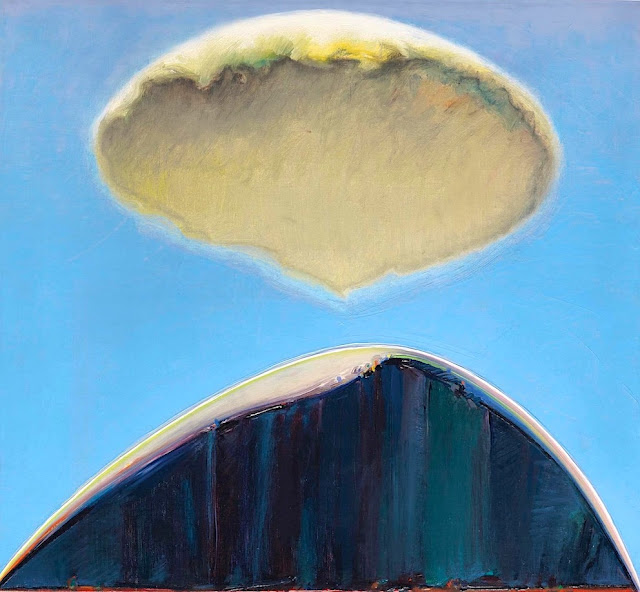
EL CAPITAN PAINTED BY WAYNE THIEBAUD


WAYNE THIEBAUD (1920-2021),El Capitan (2,309m - 7,573 ft), United States of America, In" Mount and Cloud", 1972, oil on canvas 20 1/4 x 22 in

WAYNE THIEBAUD (1920-2021)
El Capitan (2,309m - 7,573 ft)
United States of America

 In Mount and Cloud, 1972, oil on canvas 20 1/4 x 22 in.

 
The painter
Morton Wayne Thiebaud was an American painter known for his colorful works depicting commonplace objects—pies, lipsticks, paint cans, ice cream cones, pastries, and hot dogs—as well as for his landscapes and figure paintings. Thiebaud is associated with the pop art movement because of his interest in objects of mass culture, although his early works, executed during the fifties and sixties, predate the works of the classic pop artists. Thiebaud used heavy pigment and exaggerated colors to depict his subjects, and the well-defined shadows characteristic of advertisements are almost always included in his work.
Thiebaud was averse to labels such as "fine art" versus "commercial art" and described himself as "just an old-fashioned painter". He disliked Andy Warhol's "flat" and "mechanical" paintings and did not consider himself a pop artist.
In addition to pastries, Thiebaud painted characters such as Mickey Mouse as well as landscapes, streetscapes, and cityscapes, which were influenced by the work of Richard Diebenkorn. His paintings such as Sunset Streets (1985) and Flatland River (1997) are noted for their hyper realism, and have been compared to Edward Hopper's work, another artist who was fascinated with mundane scenes from everyday American life.
In 1962, Thiebaud's work was included, along with Roy Lichtenstein, Andy Warhol, Jim Dine, and Robert Dowd, in the historically important and ground-breaking "New Painting of Common Objects" curated at the Pasadena Art Museum.  This exhibition is considered to have been one of the first Pop Art exhibitions in the United States. These painters were part of a new movement, in a time of social unrest, which shocked the U.S. and the art world.

The mountain
El Capitan (2,309m - 7,573 ft) is a vertical rock formation in Yosemite National Park, located on the north side of Yosemite Valley, near its western end. The granite monolith extends about 3,000 feet (900 m) from base to summit along its tallest face and is one of the world's favorite challenges for rock climbers.
The formation was named "El Capitan" by the Mariposa Battalion when it explored the valley in 1851. El Capitan ("the captain") was taken to be a loose Spanish translation of the local Native American name for the cliff, variously transcribed as "To-to-kon oo-lah" or "To-tock-ah-noo-lah".
It is unclear if the Native American name referred to a specific tribal chief or simply meant "the chief" or "rock chief". In modern times, the formation's name is often contracted to "El Cap", especially among rock climbers and BASE jumpers.
The top of El Capitan can be reached by hiking out of Yosemite Valley on the trail next to Yosemite Falls, then proceeding west. For climbers, the challenge is to climb up the sheer granite face. There are many named climbing routes, all of them arduous, including Iron Hawk and Sea of Dreams, for example.
The Nose was first climbed in 1958 by Warren Harding, Wayne Merry and George Whitmore in 47 days using "siege" tactics: climbing in an expedition style using fixed ropes along the length of the route, linking established camps along the way.
In September 1973, Beverly Johnson and Sibylle Hechtel were the first team of women to ascend El Capitan via the Triple Direct route.

_______________________________


2022 - Wandering Vertexes...
by Francis Rousseau

Wednesday, March 16, 2022

THE SIMPLON PASS BY ANONYMOUS FRENCH PAINTER

19TH CENTURY' FRENCH SCHOOL OF PAINTING Col du Simplon (2,005 m - 6,578 ft) Switzerland  In  "Le passage des Alpes par l'armée napoléonienne",   Huile sur toile, non rentoilée, ca. 1806,   64,5 x 77 cm  Private collection

 ANONYMOUS FRENCH PAINTER
Col du Simplon (2,005 m - 6,578 ft)
Switzerland

In  "Le passage des Alpes par l'armée napoléonienne",   Huile sur toile, non rentoilée, ca. 1806,            64,5 x 77 cm  Private collection  

 
About the painting
This historical painting tells how and above all where the army of Napoleon 1st crossed the Alps to enter Italy, at the Simplon Pass (Col du Simplon). The road was built between 1801 and 1805 by the engineer Nicolas Céard, on the orders of Napoleon Bonaparte who wanted to open a passage for his artillery (described above); the cost was more than 8 million francs.  It was also Napoleon who, on February 21, 1801, without even consulting the canons of Saint-Bernard, decided to create a hospice in every way similar to that of the Col du Grand-Saint-Bernard, of which he had a lot appreciated the usefulness.  When Napoleon fell, only the first floor had been built. The building remained as it was until the mid-1820s, when work resumed and was completed in 1831.

The mountain pass
The Col du Simplon (2,005 m - 6,578 ft) (Simplon Pass in english) is a high mountain pass between the Pennine Alps and the Lepontine Alps in Switzerland. It connects Brig in the canton of Valais with Domodossola in Piedmont (Italy). The pass itself and the villages on each side of it, such as Gondo, are in Switzerland. The Simplon Tunnel was built beneath the vicinity of the pass in the early 20th century to carry rail traffic between the two countries.
The lowest point of the col (pass) and the lowest point on the watershed between the basins of the Rhone and the Po in Switzerland lies in marshland about 500 m - 1,640 ft west of the Simplon Pass settlement at an altitude of 1,994 m - 6,542 ft.
Rotelsee is a lake located near the pass at an elevation of 2,028 m (6,654 ft).
There are several great peaks around that can be climbed directly from the pass. These include Wasenhorn, Hubschhorn, Breithorn (Simplon), and Monte Leone.

The French school of painting in the 19th century
This term designates artworks produced in 19th-century France that reflects the teachings of the École des Beaux-Arts, the Parisian state-sponsored art academy.  Prioritizing draftsmanship over painting, the school taught students to employ fine line work and soft, blended shading in their drawings. Jean-Auguste-Dominique Ingres’s drawings, epitomize the Academic style, which is characterized by close attention to detail, near-invisible brushstrokes, and an emphasis on realistic modeling and shading. Academic painters often depicted scenes from history, literature, the Bible, or classical mythology, although this style can also be seen in pastoral scenes.

_______________________________

2022 - Wandering Vertexes...
by Francis Rousseau

Sunday, March 6, 2022

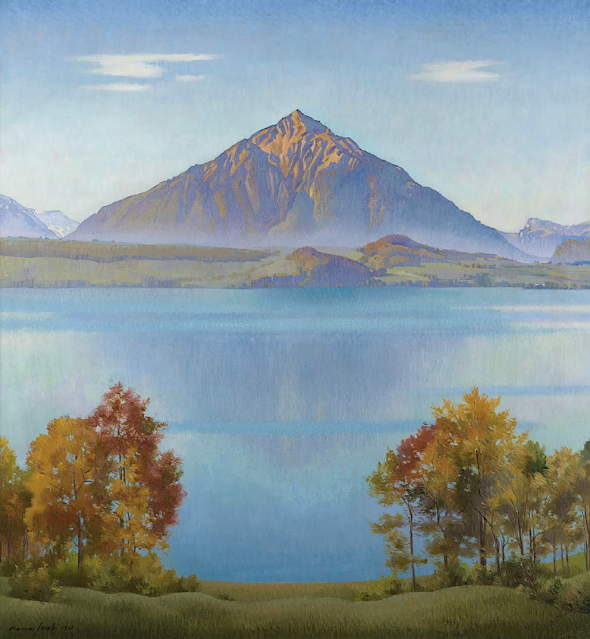
DER NIESEN PAINTED BY MARCUS JACOBI

MARCUS JACOBI (1891-1969), Der Niesen (2, 362m - 7,749 ft), Switzerland  "In The Niesen, Lake Thun, Bernese Oberland, Switzerland," oil on canvas, 105 x 96cm. 1941, Courtesy John Mitchell Fine paintings, London

MARCUS JACOBI (1891-1969)
Der Niesen (2, 362m - 7,749ft
Switzerland

In The Niesen, Lake Thun, Bernese Oberland, Switzerland, oil on canvas, 105 x 96cm, 1941,
Courtesy John Mitchell Fine paintings, London 


The mountain
The Niesen (2, 362m - 7,749ft) is a mountain of the Bernese Alps in Switzerland. It overlooks Lake Thun, in the Bernese Oberland region, and forms the northern end of a ridge that stretches north from the Albristhorn and Mannliflue, separating the Simmental and Kandertal valleys. The literal translation of the German word "Niesen" is "sneeze", but the Niesen because of its shape, is often called The Swiss Pyramid. Administratively, the summit is shared between the municipalities of Reichenbach im Kandertal, to the south-east, and Wimmis, to the west and north. Both municipalities are in the canton of Bern. The summit of the mountain can be reached easily by using the Niesenbahn funicular from Mülenen (near Reichenbach). The construction of the funicular was completed in 1910. Alongside the path of the Niesenbahn is the longest stairway in the world with 11,674 steps. It is open only once a year to the public for a stair run.
The literal translation of the German word Niesen is sneeze. Because of its shape, the Niesen is often called the Swiss Pyramid. Since the 18th century, the Niesen was the subject of a number of paintings which will all be published in this blog, one by one. The Ferdinand Holder's paintings are the two first ones to have been published. The Niesen was also the subject of a number of paintings by Paul Klee, in which it was represented as a quasi-pyramid.

The painter
Born in Biel, Marcus Jacobi came from a family of piano manufacturers and went to study medicine in Bern before becoming a painter. In the 1920s he moved to Merligen on the northern shore of Lake Thun from where this summer panorama was painted. Floating between Ferdinand Hodler and Felix Vallotton, two of the giants of Swiss twentieth century painting, Jacobi’s landscape style fused elements of Realism and Symbolism. He became known for his views of the Niesen, the volcano-like peak which rises to well over 2,000 metres and is one of Switzerland’s most iconic mountains.

__________________________________________
2022 - Wandering Vertexes...
by Francis Rousseau

Thursday, March 3, 2022

RAS MOULAY ALI PAINTED BY JACQUES MAJORELLE

JACQUES MAJORELLE (1886-1962) Ras Moulay Ali, (603 m-1 978 fr) Morocco  In "Tassa, Haut Sexaoua, Grand Atlas, le Ras Moulay Ali", Technique mixte rehaussée d'or et d'argent,1929


JACQUES MAJORELLE (1886-1962)
Ras Moulay Ali, (603 m-1 978 fr)
Morocco

In "Tassa, Haut Sexaoua, Grand Atlas, le Ras Moulay Ali", Technique mixte rehaussée d'or et d'argent,1929


About the painting
In 1926 Majorelle undertook a journey across the Kasbahs of the Atlas. Tassa, easily recognized by its impressive terrace-like layout, was a frequent source of inspiration for Majorelle in the course of 1929. His use of an elaborate technique of tempera with gold and silver highlights adds a strong graphic dimension to the painting. Applying black and ochre highlights, Majorelle subtly hints to the warm lighting of sunset, which accentuates the volume effect, highlighting the terraces and the Great-Atlas in the background. Also, the greenery diffuses an impression of coolness which is in stark contrast with the consuming heat of the dry mineral landscape.“His new compositions exude a distinctive penchant for neatness and simplicity, immense precision and an effort in researching a voluntarily decorative layout.  His fifty compositions were drawn with implacable rigor. The coloring appears in mellow hues and muted shades, which once highlighted with gold and silver, invigorate the entire composition with rich, stirring intemporality” In November 1930, in parallel with an exhibition of seventy drawings and paintings of Kasbahs held at the Renaissance gallery, a book containing thirty views of Kasbahs was also published.
(cf, Félix Marcilhac, La vie et l'œuvre de Jacques Majorelle (1886 - 1962), ed.ACR, 1995, p.137-138)

The painter
Jacques Majorelle son of the celebrated Art Nouveau furniture designer Louis Majorelle, was a French painter. He studied at the École des Beaux-Arts in Nancy in 1901 and later at the Académie Julian in Paris with Schommer and Royer. Majorelle became a noted Orientalist painter, but is most remembered for constructing the villa and gardens that now carry his name, Les Jardins Majorelle in Marrakech.
In around 1917 he travelled to Morocco to recover from heart problems and after short period spent in Casablanca, he visited Marrakech, where he fell in love with the vibrant colours and quality of light he found there. Initially, he used Marrakech as a base for trips to Spain, Italy and other parts of North Africa, including Egypt. Eventually, however, he settled in Marrakech permanently.
He drew inspiration for his paintings from his trips and from Marrakesch itself. His paintings include many street scenes, souks and kasbahs as well as portraits of local inhabitants. He opened a handicrafts workshop in Marrakech and also designed posters to promote travel to Morocco. His work was profoundly affected by his voyages around the Mediterannean and North Africa. He introduced a more coloured vision, bathed in light where the drawing disappears and the image emerges from large spots of colour laid flat. It seemed as if he had discoved the sun in these countries. His style exhibited more freedom and spontaneity.
In 1919, he married Andrée Longueville and the pair lived in an apartment near the Jemâa el-Fna Square (then at the palace of Pasha Ben Daoud). In 1923, Jacques Majorelle bought a four acre plot, situated on the border of a palm grove in Marrakech and in 1931, he commissioned the architect, Paul Sinoir, to design a Cubist villa for him. He gradually purchased additional land, extending his holding by almost 10 acres. In the grounds around the residence, Majorelle began planting a luxuriant garden which would become known as the Jardins Majorelle or Majorelle Garden. He continued to work on the garden for almost forty years. The garden is often said to be the his finest work. Majorelle developed a special shade of the colour blue, which was inspired by the blue tiles prevalent in southern Morocco. This colour was used extensively in Majorelle's house and garden, and now carries his name; Majorelle Blue.
The garden proved costly to run and in 1947, Majorelle opened the garden to the public with an admission fee designed to defray the cost of maintenance. He sold the house and land in the 1950s, after which it fell into disrepair.
Majorelle was sent to France for medical treatment in 1962 following a car accident, and died in Paris, later that year of complications from his injuries. He is buried in Nancy, the place of his birth.
During his lifetime, many of Majorelle's paintings were sold to private buyers and remain in private collections. Some of his early works can be found in Museums around his birthplace such as the Musée de l'Ecole de Nancy. Examples of his later work can be seen in the Mamounia Hotel, Marrakesch, the French Consulate of Marrakech and in the Villa at the Majorelle Gardens.

__________________________________________
2022 - Wandering Vertexes...
by Francis Rousseau


Monday, February 28, 2022

SWARTBERG MOUNTAINS SKETCHED BY DOUGLAS TREASURE


DOUGLAS TREASURE (1917-1995) The Swartberg mountains (2,325 m - 7,628 ft) South Africa (Western Cape)   In Huis Rivier Near Calitzdorp, Cape, watercolour


DOUGLAS TREASURE (1917-1995)
The Swartberg mountains (2,325 m - 7,628 ft)
South Africa (Western Cape)

 In Huis Rivier Near Calitzdorp, Cape, watercolour 


The mountains
The Swartberg mountains (2,325 m - 7,628 ft) (black mountain in Afrikaans) are a mountain range in the Western Cape province of South Africa. It is composed of two main mountain chains running roughly east–west along the northern edge of the semi-arid Little Karoo. To the north of the range lies the other large semi-arid area in South Africa, the Great Karoo. Most of the Swartberg Mountains are above 2000 m high, making them the tallest mountains in the Western Cape. It is also one of the longest, spanning some 230 km from south of Laingsburg in the west to between Willowmore and Uniondale in the east. Geologically, these mountains are part of the Cape Fold Belt. Much of the Swartberg is part of a UNESCO World Heritage Site.

The painter
Douglas Treasure obtained his formal training at the Port Elisabeth School of Art. A commercial art career included extensive experience as a illustrator, designer, visualiser and finally art director of a major company. During this time his love of watercolour landscape painting flourished, and in 1973 he retired from advertising in order to become a full-time professional painter. Douglas Treasure is the only South African represented in best selling British Author Ron Ransom's new book, Watercolour Impressionists. His works are represented in private collections in England, America, Italy, Switzerland, Germany, Australia and Argentina.

_______________________________

2022 - Wandering Vertexes...
by Francis Rousseau

Monday, February 21, 2022

THE TORRENTHORN IN VINTAGE POSTCARDS 1890


VINTAGE POSTCARDS The Torrenthorn (2,997 m - 9,832 ft) Switzerland (Valais)  In La Suisse en couleurs : Le village de Leukerbad et le Torrenthorn, Valais,  Carte postale 1890


VINTAGE POSTCARDS
The Torrenthorn (2,997 m - 9,832 ft)
Switzerland (Valais)


In  "La Suisse en couleurs : Le village de Leukerbad et le Torrenthorn, Valais", Carte postale 1890


The mountain
The Torrenthorn (2,997 m - 9,832 ft) is a summit of t he Bernese Alps, in Switzerland, located in the canton of Valais,  It is located southwest of the Majinghorn. Its western slope is part of the Loèche-les-Bains ski area, of which it overlooks the village, located to the west. The Bernese Alps are a mountain range of the Alps, located in western Switzerland.  Although the name suggests that they are located in the Berner Oberland region of the canton of Bern, portions of the Bernese Alps are in the adjacent cantons of Valais, Fribourg and Vaud, the latter being usually named Fribourg Alpsand Vaud Alps respectively. The highest mountain in the range, the Finsteraarhorn, is also the highest point in the canton of Bern. The Rhône valley separates them from the Chablais Alps in the west and from the Pennine Alps in the south; the upper Rhône valley separates them from the Lepontine Alps to the southeast; the Grimsel Pass and the Aare valley separates them from the Uri Alps in the east, and from the Emmental Alps in the north; their northwestern edge is not well defined, describing a line roughly from Lake Geneva to Lake Thun. The Bernese Alps are drained by the river Aare and its tributary the Saane in the north, the Rhône in the south, and the Reuss in the east.


Vintage postcards
Postcards were colorized as soon as they appeared on the market  at the end of 19th century ; the photos were then repainted by hand by women with very fine brushes, then a varnish was applied to fix these colors which were always very contrasting... and sometimes very far from reality!
Postcards became popular at the turn of the 20th century, especially for sending short messages to friends and relatives. They were collected right from the start, and are still sought after today by collectors of pop culture, photography, advertising, wartime memorabilia, local history, and many other categories. Postcards were an international craze, published all over the world. The Detroit Publishing Co. and Teich & Co. were two of the major publishers in the U.S, and sometimes individuals printed their own postcards as well. Yvon were the most famous in France. Many individual or anonymous publishers did exist around the world and especially in Africa and Asia (Japan, Thailand, Nepal, China, Java) between 1920 and 1955. These photographer were mostly local notables, soldiers, official guides belonging to the colonial armies (british french, belgium...) who sometimes had rather sophisticated equipment and readily produced colored photograms or explorers, navigators, climbers (Vittorio Sella and the Archiduke of Abruzzi future king of Italy remains the most famous of them).
There are many types of collectible vintage postcards.
Hold-to-light postcards were made with tissue paper surrounded by two pieces of regular paper, so light would shine through. Fold-out postcards, popular in the 1950s, had multiple postcards attached in a long strip. Real photograph postcards (RPPCs) are photographs with a postcard backing.
Novelty postcards were made using wood, aluminum, copper, and cork. Silk postcards–often embroidered over a printed image–were wrapped around cardboard and sent in see-through glassine paper envelopes; they were especially popular during World War I.
In the 1930s and 1940s, postcards were printed on brightly colored paper designed to look like linen.
Most vintage postcard collectors focus on themes, like Christmas, Halloween, portraits of movie stars, European royalty and U.S. presidents, wartime imagery, and photos of natural disasters or natural wonders. Not to mention cards featuring colorful pictures by famous artists like Alphonse Mucha, Harrison Fisher, Ellen Clapsaddle, and Frances Brundage.

__________________________________________ 


2022 - Wandering Vertexes...
by Francis Rousseau


Friday, February 18, 2022

MT SAN CRISTOBAL AND MT BANAHAW PAINTED BY FERNANDO AMORSOLO


FERNANDO AMORSOLO (1892-1972) Mount San Cristobal (1,470 m - 4,820 ft) Mount Banahaw (2, 170m - 7, 120 ft)  Philippines (Luzon)   In Harvesting rice - Mt San Cristobal in the background, Oil on canvas,  The Fernando Amorsolo foundation


FERNANDO AMORSOLO (1892-1972)
Mount San Cristobal (1,470 m - 4,820 ft)
Mount Banahaw (2, 170m - 7, 120 ft)
 Philippines (Luzon)

 In Harvesting rice - Mt San Cristobal in the background, Oil on canvas, 
The Fernando Amorsolo foundation 


The mountains
Mount San Cristobal (1,470 m - 4,820 ft) is a dormant volcano in Quezon province on the island of Luzon, Philippines. The mountain is one of the volcanic features of Macolod Corridor.Mount San Cristobal is considered the Devil's mountain in Filipino folklore. It is the alter-ego of the Holy Mountain,
Mount Banahaw,(2, 170m- 7, 120 ft)   and is part of Mounts Banahaw–San Cristobal Protected Landscape covering 10,901 hectares (26,940 acres) of land.
The mountain is bounded by San Pablo, province of Laguna at its northern slope and Dolores, province of Quezon at its southern slope.

The painter

Fernando Cueto Amorsolo was one of the most important artists in the history of painting in the Philippines.Amorsolo was a portraitist and painter of rural Philippine landscapes. He is popularly known for his craftsmanship and mastery in the use of light. After graduating from the Univeajor influences on his work. Amorsolo set up his own studio upon his return to Manila and painted prodigiously during the 1920s and the 1930s. His Rice Planting (1922), which appeared on posters and tourist brochures, became one of the most popular images of the Commonwealth of the Philippines. Beginning in the 1930s, Amorsolo's work was exhibited widely both in the Philippines and abroad. His bright,optimistic, pastoral images set the tone for Philippine painting before World War II . Except for his darker World War II-era paintings, Amorsolo painted quiet and peaceful scenes throughout his career.
Amorsolo was sought after by influential Filipinos including Luis Araneta, Antonio Araneta and Jorge B. Vargas. Amorsolo also became the favourite Philippine artist of United States officials and visitors to the country. Due to his popularity, Amorsolo had to resort to photographing his works and pasted and mounted them in an album. Prospective patrons could then choose from this catalog of his works. Amorsolo did not create exact replicas of his trademark themes; he recreated the paintings by varying some elements.
His works later appeared on the cover and pages of children textbooks, in novels, in commercial designs, in cartoons and illustrations for the Philippine publications such The Independent, Philippine Magazine, Telembang, El Renacimiento Filipino, and Excelsior. He was the director of the University of the Philippine's College of Fine Arts from 1938 to 1952.
During the 1950s until his death in 1972, Amorsolo averaged to finishing 10 paintings a month. However, during his later years, diabetes, cataracts, arthritis, headaches, dizziness and the death of two sons affected the execution of his works. Amorsolo underwent a cataract operation when he was 70 years old, a surgery that did not impede him from drawing and painting.
After being confined at the St. Luke's Hospital in Quezon City for two months, Amorsolo died at the age of 79 on April 24, 1972. The volume of paintings, sketches and studies of Amorsolo is believed to have reached more than 10,000 pieces. Amorsolo was an important influence on contemporary Filipino art and artists, even beyond the so-called "Amorsolo school." Amorsolo's influence can be seen in many landscape paintings by Filipino artists, including early landscape paintings by abstract painter Federico Aguilar Alcuaz.
In 2003, Amorsolo's children founded the Fernando C. Amorsolo Art Foundation, which is dedicated to preserving Fernando Amorsolo's legacy, promoting his style and vision, and preserving a national heritage through the conservation and promotion of his works.


__________________________________________
2022 - Wandering Vertexes...
by Francis Rousseau

Wednesday, January 26, 2022

GUNUNG BROMO (2) PAINTED BY SUDJONO ABDULLAH

SUDJONO ABDULLAH (1911-1993) Gunung Bromo (2,329m - 7,641ft) Indonesia (Java Timur)  In Sawa Landscape, 1959, oil on canvas, Private collection

SUDJONO ABDULLAH (1911-1993)
Gunung Bromo (2,329m - 7,641ft)
Indonesia (Java Timur)

In Sawa Landscape, 1959, oil on canvas, Private collection

The volcano
Gunung Bromo (2,329m - 7,641ft) or Gunung Brama, an active volcano,in East Java, Indonesia, is not the highest peak of the Tengger massif, but the best known. The massif area is one of the most visited tourist attractions in East Java, Indonesia. The volcano belongs to the Bromo Tengger Semeru National Park. The name of Bromo derived from Javanese pronunciation of Brahma, the Hindu creator god. Gunung Bromo sits in the middle of a plain called the "Sea of Sand" a protected nature reserve since 1919. The best way to visit Gunung Bromo is from the nearby mountain village of Cemoro Lawang, from where it is possible to walk during 45 mn to the volcano. It is also possible to take an organised jeep tour, which includes a stop at the viewpoint on Gunung Penanjakan (2,770 m - 9,088 ft). On the fourteenth day of the Hindu festival of Yadnya Kasada, the Tenggerese people of Probolinggo, East Java, travel up the mountain in order to make offerings of fruit, rice, vegetables, flowers and sacrifices to the mountain gods by throwing it into the caldera of the volcano. The origin of the ritual lies in the 15th century legend when princess Roro Anteng started the principality of Tengger with her husband, Joko Seger. The couple were childless and therefore beseeched the assistance of the mountain gods. The gods granted them 24 children but stipulated that the 25th child, named Kesuma, must be thrown into the volcano as a human sacrifice. The gods' request was implemented. The tradition of throwing sacrifices into the volcano to appease these ancient deities continues today and is called the Yadnya Kasada ceremony. Though fraught with danger, some locals risk climbing down into the crater in an attempt to recollect the sacrificed goods that they believe could bring them good luck.
Depending on the degree of volcanic activity, the Indonesian Centre for Volcanology and Disaster Hazard Mitigation sometimes issues warnings against visiting Mount Bromo.
Mount Bromo recently erupted in 2004, 2010, 2011 and 2015.
 

The painter
Raden Soedjono Abdullah was born in Yogyakarta, the son of Abdullah Suriosubroto, a famous landscape painter and was also the brother of Basoeki Abdullah. He used to help his father cleaning the pallet from which he found his way to be a painter. He finished his school from HIS Indonesian Dutch School and worked as a poster artist for the Rex Theater in Yogyakarta. During the Japanese colonization in Indonesia, Sudjono went to Parangtritis, Parangkusumo where he continued to paint. During the 1970s, Soedjono moved to Kertosono in East Java, where he lived up to his death.

___________________________________________

2022 - Wandering Vertexes...
by Francis Rousseau