google.com, pub-0288379932320714, DIRECT, f08c47fec0942fa0 GRAVIR LES MONTAGNES... EN PEINTURE

Tuesday, May 31, 2022

ULURU / AYERS ROCKS PHOTOGRAPHED IN 1894 BY WALTER BALDWIN SPENCER


WALTER BALDWIN SPENCER (1860-1929) Uluru /Ayers Rock (863 m -2,831 ft) Australia (Northern Territory)   In  Uluru, Ayers Rock, central Australia, 1894,  Glass plate negative 80 mm x 106 mm, Museums Victoria

WALTER BALDWIN SPENCER (1860-1929)
Uluru /Ayers Rock (863 m -2,831 ft)
Australia (Northern Territory)


In Uluru, Ayers Rock, central Australia, 1894, Glass plate negative 80 mm x 106 mm, 
Museums Victoria


The artist
Sir Walter Baldwin Spencer commonly referred to as Baldwin Spencer, was a British-Australian evolutionary biologist, anthropologist and ethnologist. He is known for his fieldwork with Aboriginal peoples in Central Australia, contributions to the study of ethnography, and academic collaborations with Frank Gillen. Spencer introduced the study of zoology at the University of Melbourne and held the title of Emeritus Professor until his death in 1929.In 1894 a new field was opened up for Spencer when he joined the W.A. Horn scientific expedition which left Adelaide in May 1894 to explore Australia. Spencer paid two more visits to the centre of Australia, one in 1923 with Dr Leonard Keith Ward, the government geologist of South Australia, and the other in 1926. These visits enabled Spencer to revise his earlier researches and consider on the spot various opposing theories that had been brought forward. His The Arunta: a Study of a Stone Age People (1927), revisits and reaffirms his earlier conclusions; Gillen's name as joint author appeared on the title-page though he had died 15 years before. Wanderings in Wild Australia, published a year later and slightly more popular in form, completes the list of his books. A list of his other published writings will be found in Spencer's Last Journey (1931). Spencer went to London in 1927 to see these books through the press. Ten years before he had said that he realised he was not getting younger and must regard his field work as finished. In February 1929, however, in his sixty-ninth year, he travelled in a cargo boat to Magallanes and then went in a little schooner to Ushuaia at the south of Tierra del Fuego. 


The mountain 
Uluru (863m -2,831 ft) also known as Ayers Rock (in honour of the then Chief Secretary of South AustraliaSir Henry Ayers) is a large sandstone rock formation in the southern part of the Northern Territory in central Australia.   Officially  the rock is gazetted as "Uluru / Ayers Rock". 
It lies 335 km (208 mi) south west of the nearest large town, Alice Springs, 450 km (280 mi) by road.
Kata Tjuta and Uluru are the two major features of the Uluṟu-Kata Tjuṯa National Park. Uluru is sacred to the Pitjantjatjara Anangu, the Aboriginal people of the area. The area around the formation is home to an abundance of springs, waterholes, rock caves, and ancient paintings.  Both Uluru and the nearby Kata Tjuta formation have great cultural significance for the Aṉangu people, the traditional inhabitants of the area, who lead walking tours to inform visitors about the local flora and fauna, bush food and the Aboriginal dreamtime stories of the area.
Uluru is notable for appearing to change colour at different times of the day and year, most notably when it glows red at dawn and sunset.
Uluru is listed as a UNESCO World Heritage Site.
Uluru is an inselberg, literally "island mountain"An inselberg is a prominent isolated residual knob or hill that rises abruptly from and is surrounded by extensive and relatively flat erosion lowlands in a hot, dry region.  Uluru is also often referred to as a monolith, although this is a somewhat ambiguous term that is generally avoided by geologists. The remarkable feature of Uluru is its homogeneity and lack of jointing and parting at bedding surfaces, leading to the lack of development of scree slopes and soil. These characteristics led to its survival, while the surrounding rocks were eroded. For the purpose of mapping and describing the geological history of the area, geologists refer to the rock strata making up Uluru as the Mutitjulu Arkose, and it is one of many sedimentary formations filling the Amadeus Basin.
According to the Aṉangu, traditional landowners of Uluru: 
The world was once a featureless place. None of the places we know existed until creator beings, in the forms of people, plants and animals, traveled widely across the land. Then, in a process of creation and destruction, they formed the landscape as we know it today. Aṉangu land is still inhabited by the spirits of dozens of these ancestral creator beings which are referred to as Tjukuritja or Waparitja.
There are a number of differing accounts given, by outsiders, of Aboriginal ancestral stories for the origins of Uluru and its many cracks and fissures. One such account, taken from Robert Layton's (1989) Uluru: An Aboriginal history of Ayers Rock, reads as follows:
Uluru was built up during the creation period by two boys who played in the mud after rain. When they had finished their game they travelled south to Wiputa ... Fighting together, the two boys made their way to the table topped Mount Conner, on top of which their bodies are preserved as boulders. 
Two other accounts are given in Norbert Brockman's (1997) Encyclopedia of Sacred Places.
The first tells of serpent beings who waged many wars around Uluru, scarring the rock. The second tells of two tribes of ancestral spirits who were invited to a feast, but were distracted by the beautiful Sleepy Lizard Women and did not show up. In response, the angry hosts sang evil into a mud sculpture that came to life as the dingo. There followed a great battle, which ended in the deaths of the leaders of both tribes. The earth itself rose up in grief at the bloodshed, becoming Uluru.
The Commonwealth Department of Environment's webpage advises:
Many...Tjukurpa such as Kalaya (Emu), Liru (poisonous snake), Lungkata (blue tongue lizard), Luunpa (kingfisher) and Tjintir-tjintirpa (willie wagtail) travel through Uluṟu-Kata Tjuṯa National Park. Other Tjukurpa affect only one specific area.
Kuniya, the woma python, lived in the rocks at Uluru where she fought the Liru, the poisonous snake.
It is sometimes reported that those who take rocks from the formation will be cursed and suffer misfortune. There have been many instances where people who removed such rocks attempted to mail them back to various agencies in an attempt to remove the perceived curse.

__________________________________________
2022 - Wandering Vertexes...
by Francis Rousseau

Saturday, May 28, 2022

MOUNT COLEMAN PAINTED BY ARTHUR P. COLEMAN

ARTHUR P. COLEMAN (1852-1939) Mount Coleman (3,135 m-10,285 ft) Canada (Alberta)
 

ARTHUR P. COLEMAN (1852-1939)
Mount Coleman (3,135 m-10,285 ft)
Canada (Alberta) 

 In  "Mountain un the Canadian rockies"

The mountain
Mount Coleman (3,135 m-10,285 ft) mountain summit located in the upper North Saskatchewan River valley in Banff National Park, in the Canadian Rockies of Alberta, Canada. Its nearest higher peak is Cirrus Mountain, 4.46 km (2.77 mi) to the north.  Mount Coleman is situated along the east side the Icefields Parkway midway between Saskatchewan Crossing and Sunwapta Pass.
Mount Coleman was named in 1898 after Arthur Philemon Coleman (1852-1939), a Canadian geologist and among the first white men to explore the area that is now Jasper National Park.(see below). Like other mountains in Banff Park, Mount Coleman is composed of sedimentary rock laid down from the Precambrian to Jurassic periods. Formed in shallow seas, this sedimentary rock was pushed east and over the top of younger rock during the Laramide orogeny.  Based on the Köppen climate classification, Mount Coleman is located in a subarctic climate with cold, snowy winters, and mild summers.  Temperatures can drop below -20 °C with wind chill factors below -30 °C. Precipitation runoff from Mount Coleman drains into tributaries of the North Saskatchewan River.

The painter
Arthur Philemon Coleman was a Canadian a geologist, professor, minerals prospector, artist, Rockies explorer, backwoods canoeist, world traveller, scientist, popular lecturer, museum administrator, memoirist and... one of Canada’s most beloved scientist.
Arthur Coleman is a fine example of that rare bird, a polished amateur artist whose drawings and paintings stand comfortably beside those of many professionals. He was active during the time when sketching and painting was ceding to photography the task of recording the visible world. Although he was also a photographer, painting was, for him, both a poetic and a descriptive pursuit, a way of wrapping an artistic expression around a phenomenon he was interested in or moved by. Thus motivated, Coleman's paintings give much joy and command a good deal of respect. The more surprising, perhaps given that he used to introduced himself more as a geologist than a painter.
Coleman travelled throughout the United States for professional conferences as well as geological field work. He visited many of the major American mountain ranges including: the American Cordillera Mountains (Washington, Oregon and California); the Sierra Nevada Mountains (California and Nevada); Yellowstone National Park (Wyoming, Montana and Idaho); and the Appalachian Mountains (eastern United States). Pleistocene glaciation had extended in Northern Europe as far south as Berlin and London and covered an area of two million square miles. Coleman also visited such countries as India, Australia, Brazil, Argentina, Scandinavia, Bolivia, New Zealand, South Africa and Uruguay. In his final years he made two expeditions to the Andes in Colombia, to mountains in Southern Mexico and to two mountains in Central America. He achieved the first ascent of Castle Mountain in 1884, and in 1907, he was the first white man to attempt to climb Mount Robson. He made a total of eight exploratory trips to the Canadian Rockies, wholly four of them looking for the mythical giants of Hooker and Brown.
From 1901 to 1922, he was a Professor of Geology at the University of Toronto and was Dean of the Faculty of Arts from 1919 to 1922. From 1931 to 1934, he was a geologist with the Department of Mines of the Government of Ontario. He was elected a Fellow of the Royal Society of Canada in 1900 and was its President in 1921. In 1929, he was appointed Honorary Vice-President of the Royal Canadian Geographical Society.
"Mount Coleman" and "Coleman Glacier" in Banff National Park is named in his honor. He was awarded the Penrose Medal in 1936.
He planned to climb "his" mountain, "Mount Coleman"'in the Albertan Rockies, and had also prepared a trip to British Guiana, but death intervened.
He was author of:
- Reports on the Economic Geology of Ontario (1903)
- Lake Ojibway; Last of the Great Glacial Lakes (1909)
- The Canadian Rockies: New and Old Trails (1911)
- Ice Ages, Recent and Ancient (1926), and was co-author of Elementary Geology (1922).
- The Last Million Years (1941) edited by George F. Kay

__________________________________________
2022 - Wandering Vertexes...
by Francis Rousseau

Wednesday, May 25, 2022

MOUNT SINAÏ / JABAL MUSA PAINTED BY J.M.W. TURNER


J.M.W. TURNER  (1775–1851) Mount Sinaï / Jabal Musa (2,285 m - 7,496ft) Egypt   In "Mount Sinai, the valley in which the Children of Israel were encamped",

J.M.W. TURNER  (1775–1851)
Mount Sinaï / Jabal Musa (2,285 m - 7,496ft)
Egypt 

In "Mount Sinai, the valley in which the Children of Israel were encamped",
pencil, pen, ink and watercolor on paper, 12.7 x 20.2 cm.
Private collection ( Christie's London/ 06/07/2010)

About this Painting
It descibes the moment Moses have waited to receive the Ten Commandments.

The mountain
Mount Sinaï (2,285 m - 7,496 ft) or Jabal Mūsā or Gabal Mūsā (in arab : "Moses' Mountain" or "Mount Moses"), also known as Mount Horeb or Jebel Musa (a similarly named mountain in Morocco), is a mountain in the Sinai Peninsula of Egypt that is a possible location of the biblical Mount Sinai. The latter is mentioned many times in the Book of Exodus (and other books of the Bible) and the Quran. According to Jewish, Christian, and Islamic tradition, the biblical Mount Sinai was the place where Moses received the Ten Commandments.
Mount Sinai is a moderately high mountain near the city of Saint Katherine in the Sinai region.
It is next to Mount Katherine (2,629 m - 8,625 ft), the highest peak in Egypt.
Mount Sinai's rocks were formed in the late stage of the Arabian-Nubian Shield's (ANS) evolution. Mount Sinai displays a ring complex that consists of alkaline granites intruded into diverse rock types, including volcanics. The granites range in composition from syenogranite to alkali feldspar granite. The volcanic rocks are alkaline to peralkaline and they are represented by subaerial flows and eruptions and subvolcanic porphyry. Generally, the nature of the exposed rocks in Mount Sinai indicates that they originated from differing depths.
There are two principal routes to the summit. The longer and shallower route, Siket El Bashait, takes about 2.5 hours on foot, though camels can be used. The steeper, more direct route (Siket Sayidna Musa) is up the 3,750 "steps of penitence" in the ravine behind the monastery.
The summit of the mountain has a mosque that is still used by Muslims. It also has a Greek Orthodox chapel, constructed in 1934 on the ruins of a 16th-century church, that is not open to the public. The chapel encloses the rock which is considered to be the source for the biblical Tablets of Stone. At the summit also is "Moses' cave", where Moses was said to have waited to receive the Ten Commandments.

The painter
The english painter Joseph Mallord William Turner was considered a controversial figure in his day, but is now regarded as the artist who elevated landscape painting to an eminence in the history of painting. Although renowned for his oil paintings, Turner is also one of the greatest masters of British watercolour landscape painting. He is commonly known as "the painter of light" and his work is regarded as a Romantic preface to Impressionism.
In his thirties, Turner travelled widely in Europe, starting with France and Switzerland in 1802 and studying in the Louvre in Paris in the same year. He made many visits to Venice. Turner's talent was recognized early in his life. Financial independence allowed Turner to innovate freely; his mature work is characterized by a chromatic palette and broadly applied atmospheric washes of paint. According to David Piper's The Illustrated History of Art, his later pictures were called "fantastic puzzles." Turner was recognized as an artistic genius: influential English art critic John Ruskin described him as the artist who could most "stirringly and truthfully measure the moods of Nature."
Turner's major venture into printmaking was the Liber Studiorum (Book of Studies), seventy prints that he worked on from 1806 to 1819. The Liber Studiorum was an expression of his intentions for landscape art. The idea was loosely based on Claude Lorrain's Liber Veritatis (Book of Truth), where Lorrain had recorded his completed paintings; a series of print copies of these drawings, by then at Devonshire House, had been a huge publishing success. Turner's plates were meant to be widely disseminated, and categorized the genre into six types: Marine, Mountainous, Pastoral, Historical, Architectural, and Elevated or Epic Pastoral. His printmaking was a major part of his output, and a museum is devoted to it, the Turner Museum in Sarasota, Florida, founded in 1974 by Douglass Montrose-Graem to house his collection of Turner prints.
Turner placed human beings in many of his paintings to indicate his affection for humanity on the one hand (note the frequent scenes of people drinking or working or walking in the foreground), but its vulnerability and vulgarity amid the 'sublime' nature of the world on the other. 'Sublime' here means awe-inspiring, savage grandeur, a natural world unmastered by man, evidence of the power of God – a theme that romanticist artists and poets were exploring in this period. Although these late paintings appear to be 'impressionistic' and therefore a forerunner of the French school, Turner was striving for expression of spirituality in the world, rather than responding primarily to optical phenomena.
Turner used pigments like carmine in his paintings, knowing that they were not long-lasting, despite the advice of contemporary experts to use more durable pigments. As a result, many of his colours have now faded greatly.
John Ruskin says in his "Notes" on Turner in March 1878 : "His true master was Dr Monro; to the practical teaching of that first patron and the wise simplicity of method of watercolour study, in which he was disciplined by him and companioned by Girtin, the healthy and constant development of the greater power is primarily to be attributed; the greatness of the power itself, it is impossible to over-estimate. "

_______________________________
2022 - Wandering Vertexes...
by Francis Rousseau

Sunday, May 22, 2022

LE GRAND VEYMONT SKETCHED BY JEAN-BAPTISTE NÉE


JEAN -BAPTISTE NÉE (b.1986) The  Grand Veymont (2,341m - 7,680 ft) France (Vercors)  In Vercors, hiver, paroi, gel (II), lavis, 2019, 16 x 25cm


JEAN -BAPTISTE NÉE (b.1986)
Le Grand Veymont (2,341m - 7,680 ft)
France (Vercors)

In Vercors, hiver, paroi, gel (II), lavis, 2019, 16 x 25cm


The artist
Jean-Baptiste Née, born in 1986. is a french painter, scenographer and visual artist, graduated from Arts-Décoratifs of Paris in 2012. Jean-Baptiste Née works in the mountains and high mountains, always in situ, in direct confrontation with the movements of the earth and water and wind. He gives a growing place for the action of the elements on the work in progress (rain, snow, frost, etc.). He established his "large workshop" in the Swiss Alps or in the Vercors massif - especially in winter -, as well as during long hikes in the Italian Alps. In the winter of 2018, he worked in the massifs of Wudangshan and Lushan, in China, and became interested in the Taoist notion of "Sky". Since 2016, Jean-Baptiste Née exhibits regularly in galleries in France and Switzerland. His workshop is in Montreuil, France. Exhibited in Galerie Camera
Obscura in Paris. A book was recently published about his work "Le monde nu" Éditions Hartpon.
Contact @jeanbaptiste.nee.
Jean Basptiste Née website

The mountain,
Le Grand Veymont (2,341m - 7,680 ft)( is  a mountain in the district of Gresse-en-Vercors, part of the department of Isère, France, is the highest point of the Massif du Vercors, but not the highest of the Vercors Regional Natural Park (which is the Rocher Rond at 2,453m).  It has a prominence of 1165 metres and an isolation of 26.88 kilometres. It is situated between le Pas de la Ville to the north and le Pas des Chattons to the south, and is part of the eastern edge of the high plateau of the Massif du Vercors.  It is preceded to the north by (north to south) "le Rocher de Séguret" (the Rock of Séguret, 2051 metres), "Roche Rousse" (Red Rock, 2105 metres), and "le Sommet de Pierre-Blanche" (the Summit of White Rock, 2106 metres)  and followed to the south (north to south) by Petit Veymont or Aiguillette (little Veymont or small needle, 2120 metres) and Mont Aiguille (Mount Needle, 2085 metres). Due to its location in the Parc du Vercors, it is far from any paved road. A moderately easy route to the summit involves walking about 10 km, hiking through the backcountry.
On 10 February 2007, a twin-engine light aircraft flying from London to Cannes disappeared in a snowstorm over le Grand Veymont, crashing into the mountainside and killing all three people aboard. The bodies and wreckage were recovered less than 24 hours later, at around 1960 metres above sea level, close to the Pas de la Ville, after a rescue operation involving more than one hundred policemen, firemen, mountain rescue specialists, and three helicopters equipped with infra-red cameras.

Thursday, May 19, 2022

CERRO ACONCAGUA PAINTED BY RHOD WULFARS


RHOD WULFARS (bn. 1979) Aconcagua (6,961 m -22,838 ft) Argentina  In "Aconcagua," Acrylic on canvas, 18 x 24cm

RHOD WULFARS (bn. 1979)
Aconcagua (6,961 m -22,838 ft)
Argentina

In "Aconcagua," Acrylic on canvas, 18 x 24cm


The artist
Rhod Wulfars is a contemporary mountain painter using mainly acrylic technique for his paintings.
He was born in 1979 in Mendoza (Argentina). In his website he wrote: "I have spent my whole life by the mountains. On day I started to paint them". Using, in the manner of Nicolas de Staël, a style always beetween abstract and figurative, his very strong and very moving paintings described perfectly the majesty and the spectacular contents of the peaks he paints. Rhod Wulfars makes a surprising use of acrylic medium, in thick paste as one could do with oil paint. He used to named his works only bu numbers, and series letters, but sometime he writes the name of the peaks ans makes it more easy to identify.
Other works by this artist on his website : rhodwulfars.wixsite.com/rhodwulfars/
Contact : @rhodwulfars


The mountain
Cerro Aconcagua (6,961 meters -22,838 ft) or simplynThe Aconcagua is the highest mountain outside of Asia and by extension the highest point in both the Western Hemisphere and the Southern Hemisphere.
Aconcagua is not a volcano.  he origin of the name is contested; it is either from the Mapuche "Aconca-Hue", which refers to the Aconcagua River, the Quechua "Ackon Cahuak", meaning "Sentinel of Stone", or Quechua "Anco Cahuac", meaning "White Sentinel" or the Aymara "Janq'u Q'awa" meaning "White Ravine", "White Brook".
Aconcagua is located in the Andes mountain range, in the Mendoza Province, Argentina, and lies 112 kilometers (70 mi) northwest of its capital, the city of Mendoza and 108 km (67 mi) from Santiago de Chile (the capital of Chile). The summit is in fact located about 5 kilometers from San Juan Province and 15 kilometers from the international border with Chile; its nearest higher neighbor is Tirich Mir in the Hindu Kush, 16,520 kilometers (10,270 mi) away.
Aconcagua is one of the Seven Summit, which includes the highest mountains of each of the seven continents. The 7 summits (which are obviously 8 !)... are : Mt Everest (8,848m), Mt Denali or Mc Kinley (6,194m), Kilimandjaro (5,895m), Mt Elbrus (5,642m), Vinson Massif (4,892m), Mt Blanc (4,807m) and Mount Kosciuszko (2,228m). Summiting all of them is regarded as a mountaineering challenge, first achieved on April 30, 1985 by Richard Bass.
The mountain and its surroundings are part of the Aconcagua Provincial Park. The mountain has a number of glaciers. The largest glacier is the Ventisquero Horcones Inferior at about 10 km long, which descends from the south face to about 3600 m altitude near the Confluencia camp. Two other large glacier systems are the Ventisquero de las Vacas Sur and Glaciar Este/Ventisquero Relinchos system at about 5 km. 

___________________________

2022 - Wandering Vertexes...
by Francis Rousseau


Monday, May 16, 2022

LE PRABÉ PAINTED BY EDOUARD VALLET

ÉDOUARD VALLET (1876-1929) Le Prabé (2, 042m-  6,699ft) Switzerland (Valais)  In "Savièse in Valais (Morning in the mountains)", 1912
 
ÉDOUARD VALLET (1876-1929)
Le Prabé (2, 042m -  6,699ft)
Switzerland (Valais)

In "Savièse in Valais (Morning in the mountains)", oil on canvas, 1912, Private collection

The mountain 
Le Prabé (2, 042m -  6,699ft) is a mountain of the Bernese Alps, overlooking Savièse in the canton of Valais. It lies at the southern end of the ridge that descends from the Wildhorn and the Sex Noir. Although the Prabé has almost no topographic prominence, it dominates the Rhone valley with a height of more than 1,500 metres.

The Painter
Édouard Eugène Francis Vallet (1876 -1929) was a Swiss artist. Born in Geneva he went to a boarding school in France and apprenticed as a stonemason in 1892. He then went to the Geneva College of Fine Arts and studied woodcuts under Alfred Martin, Pierre Pignolat and Barthélemy Menn. He also travelled to Germany and Italy and held his first exhibition in 1899. He lived in the Swiss mountains in Valais, Savièse, Ayent, Hérémence, Vercorin and Sion from 1908 and painted portraits and landscapes from the region. He married the painter Marguerite Gilliard, daughter of the artist Eugène Gilliard (1861-1921) and after her death in 1918, he married Marie Jollien (1886-1951). Vallet died in 1929 and is buried in the cemetery at Confignon.

 ___________________________

2022 - Wandering Vertexes...
by Francis Rousseau

Friday, May 13, 2022

ALEXANDRA PEAK AND MARGHERITA PEAK BY VITTORIO SELLA


VITTORIO SELLA (1859-1943) Alexandra Peak / Mount Stanley (5,091m - 16,703 ft) Congo - Uganda border    In Alexandra peak and Margherita peak from the Stanley Plateau, photo, 1906


VITTORIO SELLA (1859-1943)
Alexandra Peak / Mount Stanley (5, 091m - 16,703 ft)
Margherita Peak / mount stanley (5,109 m-16,763 ft)
Congo - Uganda border

  In Alexandra peak  and Margherita peak from the Stanley Plateau, photo, 1906


The mountain
Alexandra Peak (5,091m - 16,703ft) is part of Mount Stanley located in the Rwenzori range, the highest mountain of both Democratic Republic of the Congo and Uganda, and the third highest in Africa, after Mount Kilimanjaro (5,895 m -19,340ft) and Mount Kenya (5,199 m - 17,057ft).
Mount Stanley consists of two twin summits and several lower peaks which are :
Margherita Peak (5,109m - 16,763ft), Alexandra Peak (5,091m - 16,703ft), Albert Peak (5,087m - 16,690ft), Savoia Peak (4,977m - 16,330ft), Ellena Peak (4,968m -16,300ft), Elizabeth Peak (4,929m - 16,170 ft), Phillip Peak (4,920m - 16,140ft), Moebius Peak (4,916m - 16,130 ft) and Great Tooth (4,603m - 15,100ft).
The peak and several other surrounding peaks are high enough to support glaciers. Mount Stanley is named for the journalist and explorer, Sir Henry Morton Stanley. It is part of the Rwenzori Mountains National Park, a UNESCO world Heritage Site.
Mt. Stanley was first climbed in 1906 by the Prince Luigi Amedeo di Savoia , Duke of the Abruzzi, (1873-1933), J. Petigax, C. Ollier, and J. Brocherel. He is known as well for his Arctic explorations and for his mountaineering expeditions, particularly to Mount Saint Elias (Alaska–Yukon) and K2 (Pakistan–China). Margherita Peak is named after Queen Margherita of Italy the prince's cousin.
The Rwenzori Mountains National Park is considered a model for integration of cultural values into the Protected Area Management framework as an innovative approach to resource management, the first of its kind in Africa. As a result the local communities have embraced collaborative resource management initiatives. Given its significance as one of the biodiversity hotspots in the Albertine Rift, various local and international NGOs have supported the management and conservation of the property. A General Management Plan guides management operations on-site. Key challenges to address include illegal felling of trees, snow recession due to global warming, human population pressure adjacent to the property and management of waste generated through tourism operations. UWA is addressing the above threats through resource protection, community conservation education, research and ranger-based monitoring, ecotourism and transboundary initiatives with the DRC. The long-term maintenance of the integrity of the property will be achieved through sustainable financing, ecological monitoring, continued collaboration with key stakeholders and regional cooperation.

The artist
Vittorio Sella is a mountain italian climber and photographer who took his passion for mountains from his uncle, Quintino Sella, founder of the Italian Alpine Club. He accomplished many remarkable climbs in the Alps, the first wintering in the Matterhorn and Mount Rose (1882) and the first winter crossing of Mont Blanc (1888) and Les Rouies (1900).
He took part in various expeditions outside Italy:
- Three in the Caucasus in 1889, 1890 and 1896 where a summit still bears his name;
- The ascent of Mount Saint Elias in Alaska in 1897;
- Sikkim and Nepal in 1899;
- Possibly climb Mount Stanley in Uganda in 1906 during an expedition to the Rwenzori;
- Recognition at K2 in 1909;
- In Morocco in 1925.
During expeditions in Alaska, Uganda and Karakoram, he accompanied the Duke of Abruzzi, Prince Luigi Amedeo di Savoia.
Sella continues the practice of climbing into his old age, completing his final attempt in the Matterhorn at the age of 76; a climb he had to interrupt the rise following an accident in which one of his guides injured. He died in his hometown during World War II. His photographic collection is now managed by the Sella Foundation.
His photos mountain are still considered today to be among the finest ever made.
Jim Curran believes that "Sella remains probably the greatest photographer of the mountain. His name is synonymous with technical perfection and aesthetic refinement. "
The quality of the pictures of Vittorio Sella is partly explained by the use of a view camera 30 × 40 cm, despite the difficulty of the transportation of such a device, both heavy and fragile in places inaccessible; to be able to transport it safely, he had to make special pieces that can be stored in saddle bags. His photographs have been widely distributed, either through the press or in the galleries, and were unanimously celebrated; Ansel Adams, who was able to admire thirty-one in an exhibition that was organized at Sella American Sierra Club, said they inspired him "a religious kind of sense of wonder." Many of his pictures were taken in the mountains for the very first time in the History, which give them a much artistic, historical but also scientific value ; for example, one could measure the decline in the Rwenzori glaciers in Central Africa.
___________________________

2022 - Wandering Vertexes...
by Francis Rousseau

Tuesday, May 10, 2022

THE WATERBERG PAINTED BY JACOBUS HENDRIK PIERNEEF


JACOBUS HENDRIK PIERNEEF (1886-1957) The Waterberg (18,30 m - 6,003 ft) South Africa (Limpopo)  In Bushveld, 1942, watercolor
 
JACOBUS HENDRIK PIERNEEF (1886-1957)
The Waterberg (1, 830 m - 6, 003 ft)
South Africa (Limpopo)

In Bushveld, 1942, watercolor


The Mountains 

The Waterberg (1,830 m - 6,003 ft) (Thaba Meetse) is a mountainous massif of approximately 654,033 hectare in north Limpopo Province, South Africa. The average height of the mountain range is 600 m with a few peaks rising up to 2000 m above sea level. Vaalwater town is located just north of the mountain range. The extensive rock formation was shaped by hundreds of millions of years of riverine erosion to yield diverse bluff and butte landform. The ecosystem can be characterised as a dry deciduous forest or Bushveld. Within the Waterberg there are archaeological finds dating to the Stone Age, and nearby are early evolutionary finds related to the origin of humans. Waterberg is the first region in the northern part of South Africa to be named as a Biosphere Reserve by UNESCO.

The painter

Jacobus Hendrik (Henk) Pierneef (usually referred to as Pierneef) was a South African landscape artist, generally considered to be one of the best of the old South African masters. His distinctive style is widely recognized and his work was greatly influenced by the South African landscape.
Most of his landscapes were of the South African highveld, which provided a lifelong source of inspiration for him. Pierneef's style was to reduce and simplify the landscape to geometric structures, using flat planes, lines and colour to present the harmony and order in nature. This resulted in formalised, ordered and often-monumental view of the South African landscape, uninhabited and with dramatic light and colour.
Pierneef's work can be seen worldwide in many private, corporate and public collections, including the Africana Museum, Durban Art Gallery, Johannesburg Art Gallery, King George VI Art Gallery, Pierneef Museum and the Pretoria Art Gallery.

___________________________

2022 - Wandering Vertexes...
by Francis Rousseau


Saturday, May 7, 2022

MOUNT DAMAVAND / دماوند SKETCHED BY HUSAYN WA'IZ KASHIFI


HUSAYN VAIZ KASHIFI  i(died 1504-1505) Mount Damavand (5, 610m -18,410ft) Iran  In The Anvār-i Suhaylī or Lights of Canopus, 1847, The Walters Art Museum


HUSAYN WA'IZ KASHIFI (840 /1436 - 910/ 1505)
Mount Damavand   (6,105m-18,410ft)
Iran

In The Anvār-i Suhaylī or Lights of Canopus, The Walters Art Museum, Baltimore


About this work
Walters Art Museum manuscript W.599 is an illuminated and illustrated copy of Anvar-i Suhayli (The lights of Canopus), dating to the 13th century AH/AD 19thand attributed to Husayn  Kashifi
It is a Persian version of Kalilah wa-Dimnah (The fables of Bidpay). It was completed on 26 Jumadá I 1264 AH/AD 1847 by Mirza Rahim. The text is written in Nasta'liq script in black and red ink, revealing the influence of Shikastah script. There are 123 paintings illustrating the text. The Qajar binding is original to the manuscript.

The mountain
Mount Damāvand (5, 610m -18,410ft), in Persian دماوند‎‎ , a potentially active volcano, is a stratovolcano which is the highest peak in Iran and the Middle East as well as the highest volcano in Asia (the Kunlun Volcanic Group in Tibet has a higher elevation than Damāvand, but are not considered to be volcanic mountains). It has a special place in Persian mythology and folklore.The origins and meaning of the word "Damavand" is unclear, yet some prominent researchers have speculated that it probably means "The mountain from which smoke and ash arises", alluding to the volcanic nature of the mountain.
This peak is located in the middle of the Alborz range, adjacent to Varārū, Sesang, Gol-e Zard, and Mīānrūd. The mountain is located near the southern coast of the Caspian Sea, in Amol County, Mazandaran Province, 66 kilometres (41 miles) northeast of the city of Tehran. Mount Damāvand is the 12th most prominent peak in the world, and the second most prominent in Asia after Mount Everest. It is the highest volcanic mountain in Asia, and part of the Volcanic Seven Summits mountaineering challenge. Damavand is a significant mountain in Persian mythology. It is the symbol of Iranian resistance against despotism and foreign rule in Persian poetry and literature. In Zoroastrian texts and mythology, the three-headed dragon Aži Dahāka was chained within Mount Damāvand, there to remain until the end of the world. In a later version of the same legend, the tyrant Zahhāk was also chained in a cave somewhere in Mount Damāvand after being defeated by Kāveh and Fereydūn. Persian poet Ferdowsi depicts this event in his masterpiece, the Shahnameh, in which the mountain is said to hold magical powers. Damāvand has also been named in the Iranian legend of Arash (as recounted by Bal'ami) as the location from which the hero shot his magical arrow to mark the border of Iran, during the border dispute between Iran and Turan. The famous poem Damāvand by Mohammad Taqī Bahār is also one fine example of the mountain's significance in Persian literature.
Mount Damavand is depicted on the reverse of the Iranian 10,000 rials banknote.
An anthropologist of Mazandaran Cultural Heritage and Tourism Department, Touba Osanlou, has said that a proposal has been put forward by a group of Iranian mountaineers to register the highest peak in the Middle East, Mount Damavand as a national heritage site. Mazandaran Cultural Heritage and Tourism Department has accepted the proposal, the Persian daily Jam-e Jam reported.

The artist
Kamāl al-Dīn Ḥusayn ibn Alī Kashifi, best simply known as Husayn Kashifi, was a prolific Persia] prose-stylist, a poet, a Quran exegete, a Sufi scholar, and an astronomer of the Timurid era. Kashifi was his pen name, whereas his surname al-Wāʿiẓ ("the preacher") denoted his professional occupation. He spent most of his career in Herat, where his academic activities were supported by Ali-Shir Nava'i, a senior vizier in the Timurid court during Sultan Husayn Bayqara's rule, hence the reason for Kashifi to dedicate most of his works to Nava'i. He was also very close to the famous Persian poet and Sufi, Nur al-Din 'Abd al-Rahman Jami. His famous works include Akhlaq-e Mohseni and Anwar-e Sohaili  (above) in Persian prose, and Jawaher al-Tafsir and Mawaheb-e 'Aliyya which are Persian tafsirs of the Quran.

_______________________________________

2022 - Wandering Vertexes...
by Francis Rousseau


Wednesday, May 4, 2022

THE DIAMONDS MOUNTAINS / MT KUMGANG PAINTED BY JEONG SEON / 정선

JEONG SEON  / 정선 (1676–1759) Mount Kumgang / The Diamond Mountains (1,638 m - 5,374 ft) South Corea   In Geumgangjeondo  "Overview of Mt. Geumgang in Autumn" or The Diamond Mountains, 1734, Ink and light colors on paper, 130.7 cm × 94.1 cm, Ho-Am Art Museum, South Korea


JEONG SEON  / 정선 (1676–1759)
Mount Kumgang / The Diamond Mountains (1,638 m - 5,374 ft)
North Corea


In Geumgangjeondo "Overview of Mt. Geumgang in Autumn" or The Diamond Mountains, 1734,
Ink and light colors on paper, 130.7 cm × 94.1 cm, Ho-Am Art Museum, South Korea


About this work
Geumgang jeondo (금강전도 金剛全圖) is a famous landscape painted by Jeong Seon during the reign of King Yeongjo, litteterally means " General view of Mt. Geumgangsan" or The Diamond Mountains). It was classified as the 217th National Treasure of South Korea on August 6, 1984. The painting is currently held and managed by the Ho-Am Art Museum in Yongin, Gyeonggi Province and is owned by Lee Kun-hee. While many contemporaneous painters imitated the latest art trends from China, Jeong Seon ignored these to create unique themes based on Korean landscapes. His catalogue of paintings of Geumgansan made him famous and the preeminent painter of his time at the age of 37. He eventually painted around 100 images of the mountains which still exist to this day. The artist’s love of the mountains influenced other artists to depict the Diamond Mountains and even encouraged mapmakers to make maps of the area. Although Jeong Seon made many paintings of Mt. Geumgangsan, this painting is the largest and considered his best. Like many of his paintings, Jeong Seon painted this landscape while actually viewing the mountains. The painting is 130.7 centimeters in height and 94.1 centimeters in width. It is painted with India ink. The painting is of Naegeumgang, the Inner Mt. Geumgangsan. The painting depicts a total of twelve thousand peaks. The highest peak, Birobong, lies in the background and water flows from it toward a valley called Manpokdong which is divided from the left and right. The high sharp peaks are depicted by the artist with lines painted up and down while the artist used a dotting brush method to depict the earthen peaks, making them appear relatively soft and lush. This composition harmonizes the contrasting sharp edges of the rocky peaks with the softer earthen peaks.

The mountain
Mount Kumgang / 금강산 (1,638 m - 5,374 ft Geumgangsan,(Diamond Mountain) are a mountain/mountain range, with a Birobong peak, in Kangwon-do, North Korea. It is about 50 kilometres (31 mi) from the South Korean city of Sokcho in Gangwon-do. It is one of the best-known mountains in North Korea. It is located on the east coast of the country, in Mount Kumgang Tourist Region, formerly part of Kangwŏn Province. Mount Kumgang is part of the Taebaek mountain range which runs along the east of the Korean Peninsula.
Koreans have perceived Kŭmgangsan as their muse since well before the Middle Ages.  Practically every poet and artist who lived during the Joseon dynasty (1392-1910) made a pilgrimage to Kŭmgangsan. Among other well-known works, are the Geumgang jeondo and the Pungaknaesan chongramdo, painted in the 1740s by Jeong Seon.  The division of the Korean peninsula in 1950 resulted in the South Korean people finding themselves unable to visit this beloved mountain for the better part of 50 years.  The 155-mile-long (249 km) barbed-wire fence erected as part of the DMZ( Demilitarized zone) separating the two Koreas proved to be an obstacle stronger than any other barrier.
 In 1894 the British writer Isabella Bird Bishop referred to it in her travelogue as "Diamond Mountain".
Kŭmgangsan is the subject of a popular 1962 South Korean folk song, Longing for Mt. Geumgang. It is also the setting of the 1973 North Korean revolutionary opera The Song of Mount Kumgang.
The legend of the Sad Korean frog: During the Korean War, the civilian population had to hide in the mountainous areas to avoid being victims of the continuous attacks of the armies. In the autumn of 1950, one of the villages in the area was reportedly razed to the ground by the South Korean and Allied armies advancing through the area. The attack took place in the morning and almost all the inhabitants were killed. It is said that about twenty children managed to escape and fled to the foothills of the mountain. There they found shelter and stayed there for several days. When they wanted to return to their village, already destroyed, they saw that the military had built a logistic base there and decided to stay in the mountain for a week. They barely had enough food for everyone and were beginning to starve. When all seemed lost, with the children so weak that they could barely leave the shelter on the mountainside, they found a sack with twenty loaves of bread next to their makeshift beds of leaves at dawn. Thanks to these loaves of bread and water from the nearby stream, which always arrived at dawn, the children managed to gather strength and survive. One night, several of the children stayed awake and saw a small frog carrying the sack with the loaves of bread. They decided to follow it almost to the top of the mountain and saw that in one of the many caves there, the frog was kneading and baking bread every night so that the children would have food.
Thanks to the Sad Korean frog, as it was called in some writings because of its sorrowful appearance, the children managed to live long enough to return to their village. Eventually these children grew up and went to other villages where they told their story and thus the Mountain Frog (san-eseo seulpeun gaeguli) became known as the Mountain Frog.

The painter
Jeong Seon (정선)  was a Korean landscape painter, also known by his pen name Kyomjae ("humble study"). His works include ink and oriental water paintings, such as Inwangjesaekdo (1751), Geumgang jeondo, and Ingokjeongsa (1742), as well as numerous "true-view" landscape paintings on the subject of Korea and the history of its culture.  He is counted among the most famous Korean painters.  The landscape paintings that he produced reflect most of the geographical features of Korea.  The poverty he experienced in his youth made him pursue his career as a painter.  He was proficient at Zhou-I and astronomy. He worked at the Bureau of Painting creating landscapes for patrons and clients.
He was discovered by an aristocratic neighbour who recommended him to the court. He soon gained an official position. Jeong is said to have painted daily, with a prolific output until old age. 
Jeong was the most eminent painter in the late Joseon Dynasty (1700–1850) and explored the scenic beauty of the capital city of Hanyang (Seoul), the Han River, the East Sea, and the Diamond Mountain (above). He is the first painter of true-view Korean landscapes. Differing from earlier techniques and traditional Chinese styles, he created a new style of painting depicting the virtues of Korea. It is reported that he frequently left his studio and painted the world around him, as he could see it. His paintings are classified as Southern School, but he developed his own style by realistically portraying natural scenes such as mountains and streams with bold strokes of his brush.
A major characteristic of his work is intermixed dark and light areas, created by layers of ink wash and lines. His mountains are punctuated by forests, which in turn are lightened by mists and waterfalls. Vegetation is made from dots, a technique that bears the influence of Chinese painter Mi Fei (1052–1107). Jeong's style would influence generations of Korean artists, and become one of the iconic images of Korean nationalism.

_______________________________________

2022 - Wandering Vertexes...
by Francis Rousseau


Sunday, May 1, 2022

MOUNT HAKU / 白山 BY HIROSHIGE II / 二代目 歌川広重

HIROSHIGE II (1826 - 1869) Mount Haku /白山, (2,702.2 m -8,865 ft Japan ( Honshu)   In Mount Haku, Kaga Province,  Woodblock Print,  1862- in Sixty-eight Views of the Various Provinces, 1862


HIROSHIGE II  /  二代目 歌川広重 (1826 - 1869)
Mount Haku /白山, (2,702.2 m -8,865 ft
Japan ( Honshu)

 In Mount Haku, Kaga Province,  Woodblock Print,  1862- in Sixty-eight Views of the Various Provinces, 1862

The mountain
Mount Haku /白山 (2,702.2 m -8,865 ft), meaning"White Mountain", or Mount Hakusan (commonly referred to as simply Hakusan), is a dormant stratovolcano in Japan. It is located on the borders of Gifu and Ishikawa, on the island of Honshu. Mount Haku is thought  to have first been active 300,000 to 400,000 years ago, with the most recent eruption occurring in 1659. Along with Mount Tate and Mount Fuji, it is one of Japan's "Three Holy Mountains". The mountain's tallest peak, Gozenga-mine (御前峰), is the one that gives the mountain its height of 2,702 m (8,865 ft). Along with Ken-ga-mine (剣ヶ峰), which is 2,677 m (8,783 ft), and Ōnanji-mine (大汝峰), which is 2,648 m (8,688 ft), the three peaks are considered "Mount Haku's Three Peaks" (白山三峰 Hakusan San-mine). Mount Bessan and Mount Sannomine are sometimes included and called "Mount Haku's Five Peaks" (白山五峰). Because it is very prominent and clearly visible from the nearby coast, even after the surrounding mountains have lost their snow, Mount Haku still appears white, which is one explanation for the mountain's name, which means "white mountain." It is also the westernmost mountain in Japan that is over 2,000 m (6,562 ft) in height. Taichō, a mountain Shugendo monk, first climbed Mount Hakusan in 717. For hundreds of years, people have come to Haku for prayers (白山信仰). A branch shrine of Shirayama Hime Shrine, which served as the supreme shrine for Kaga Province, is on the mountain. The Shirayama Hime Shrine is the main shrine (総本社) of approximately 2,000 Hakusan shrines (白山神社) in Japan. In 1980 an area of 48,000 ha was designated a UNESCO Man and the Biosphere Reserve. Mount Haku was designated as a quasi-national park in 1955. It became a national park in 1962 and was renamed Hakusan National Park. Because the central part of the mountain has much precipitous terrain, there are very few roads and, as a result, little human intrusion into the area. Also limiting human intrusion is the designation of the park as a Wildlife Protection Area, covering over 38,061 ha. The park stretches beyond the mountain's borders into Toyama Prefecture.


The artist
Hiroshige II (二代目 歌川広重) 1826 – 17 September 1869) was a Japanese designer of ukiyo-e art. He inherited the name Hiroshige II following the death in 1858 of his master Utagawa Hiroshige (歌川 広重), whose daughter he married. In 1865 he moved from Edo to Yokohama after dissolving his marriage and began using the name Kisai Risshō (喜斎立祥). His work so resembles that of his master that scholars have often confused them.
Born Suzuki Chinpei (鈴木鎮平) in 1826, it is said that he was born to a fireman, as was his master Utagawa Hiroshige (歌川 広重), to whom he became apprenticed under the name Shigenobu at an unknown age. His earliest known work is the illustrations for a book called Twenty-four Paragons of Japan and China from 1849. Hiroshige II produced a large number of commissioned work in the 1850s in the style of the elder Hiroshige, and often signed his work Ichiryūsai mon ("student of Ichiryūsai", another art name of Hiroshige I's), and from c. 1853 to 1858 simply as Ichiryūsai. In 1858, he married Hiroshige I's daughter Otatsu after the master's death and inherited the Hiroshige name, as well as the names Ichiryūsai and Ryūsai.
Utagawa Hiroshige (歌川 広重) took on few students; Hiroshige II was the most successful of these. His works have often been confounded with those of his master, which they resemble closely in style, subject, and signature. Early Western scholars did not even recognize him as a separate artist. Another pupil of the first Hiroshige, Shigemasa, later married the master's daughter, Otatsu, and also began using the name Hiroshige; this artist now is known as Hiroshige III.


__________________________________________

2022 - Wandering Vertexes...
by Francis Rousseau

Friday, April 29, 2022

MOUNT VESUVIUS SEEN FROM SORRENTE BY ALFRED DE CURZON


ALFRED DE CURZON (1820-1895) Mount Vesuvius (1,281 m- 4,203 ft at present) Italy  In "Sorrente, devant la mer de Naples ", 1851 Huile sur papier marouflé sur toile 24,5 x 33 cm, Collection privée, courtesy Galerie d'Athènes, Paris


ALFRED DE CURZON (1820-1895)
Mount Vesuvius (1,281 m- 4,203 ft at present)
Italy

In "Sorrente, devant la mer de Naples ", 1851, huile sur papier marouflé sur toile 24,5 x 33 cm,
Collection privée, courtesy Galerie d'Athènes, Paris

The painter
Alfred de Curzon is a French painter, grandson of Joseph-Emmanuel-Auguste-François de Lambertye and brother of Emmanuel Parent de Curzon. Alfred de Curzon's family is part of the aristocracy of western France. While he was a student, the painting Médée furieuse by Eugène Delacroix, exhibited at the Salon of 1838, made a strong impression on him. He tries his hand at pastel and decides to become a painter. He entered the 1 April 1840 at the School of Fine Arts in Paris in the studio of Michel Martin Drolling. On the advice of one of his classmates from the school, Louis Georges Brillouin (1817-1893), he changed studio to follow the lessons of Louis Cabat from 1845.
In 1849 he painted La Mort de Milon de Crotone. At the request of the Academy, he obtained from the minister the enjoyment of the pension of Rome for two years. There he met Alexandre Cabanel, Jean-Achille Benouville, François-Léon Benouville, Louis Français and Charles Busson who remained his friend. He travel to Greece in 1852 with the writer Edmond About and the architect Charles Garnier. Greek antiquity then strongly impregnated him and is found in many of his paintings.
He began at the Salon of 1843 with a painting entitled Landscape. He obtained a 2nd class medal in 1857, followed by recalls in 1859, 1861 and 1863. He was awarded a 3rd class medal at the Universal Exhibition of 1867.
Charles Baudelaire notes, in his Salon of 1845: "A serenade in a boat, - is one of the most distinguished things of the Salon. - The arrangement of all these figures is very happily conceived; the old man at the end of the boat, lying in the middle of the garlands, is a very pretty idea. - The compositions of M. Brillouin and that of M. Curzon have some analogy; they have this above all in common, that they are well drawn - and drawn with spirit."
Alfred de Curzon practiced all genres, but it was his landscapes that made him famous. Many drawings can be seen at the Sainte-Croix museum in Poitiers (France).

The mountain 
Mount Vesuvius (1,281 m- 4,203 ft at present) is one of those legendary and mythic mountains  the Earth  paid regularly tribute. Monte Vesuvio in Italian modern langage or Mons Vesuvius in antique Latin langage is a stratovolcano in the Gulf of Naples (Italy) about 9 km (5.6 mi) east of Naples and a short distance from the shore. 
It is one of several volcanoes which form the Campanian volcanic arc. Vesuvius consists of a large cone partially encircled by the steep rim of a summit caldera caused by the collapse of an earlier and originally much higher structure.
Mount Vesuvius is best known for its eruption in AD 79 that led to the burying and destruction of the Roman antique cities of Pompeii, Herculaneum, and several other settlements. That eruption ejected a cloud of stones, ash, and fumes to a height of 33 km (20.5 mi), spewing molten rock and pulverized pumice at the rate of 1.5 million tons per second, ultimately releasing a hundred thousand times the thermal energy released by the Hiroshima bombing. At least 1,000 people died in the eruption. The only surviving eyewitness account of the event consists of two letters by Pliny the Younger to the historian Tacitus.
Vesuvius has erupted many times since and is the only volcano on the European mainland to have erupted within the last hundred years. Nowadays, it is regarded as one of the most dangerous volcanoes in the world because of the population of 3,000,000 people living nearby and its tendency towards explosive eruptions (said Plinian eruptions). It is the most densely populated volcanic region in the world.
Vesuvius was formed as a result of the collision of two tectonic plates, the African and the Eurasian. The former was subducted beneath the latter, deeper into the earth. As the water-saturated sediments of the oceanic African plate were pushed to hotter depths in the earth, the water boiled off and caused the melting point of the upper mantle to drop enough to create partial melting of the rocks. Because magma is less dense than the solid rock around it, it was pushed upward. Finding a weak place at the Earth's surface it broke through, producing the volcano.
he area around Vesuvius was officially declared a national park on June 5, 1995. The summit of Vesuvius is open to visitors and there is a small network of paths around the mountain that are maintained by the park authorities on weekends.
There is access by road to within 200 metres (660 ft) of the summit (measured vertically), but thereafter access is on foot only. There is a spiral walkway around the mountain from the road to the crater.
The first funicular cable car on Mount Vesuvius opened in 1880. It was later destroyed by the 1944 eruption. "Funiculì, Funiculà", a famous Neapolitan song with lyrics by journalist Peppino Turco set to music by composer Luigi Denza, commemorates its opening.
 
_______________________________

2022 - Wandering Vertexes / Mountain painting
By Francis Rousseau

Tuesday, April 26, 2022

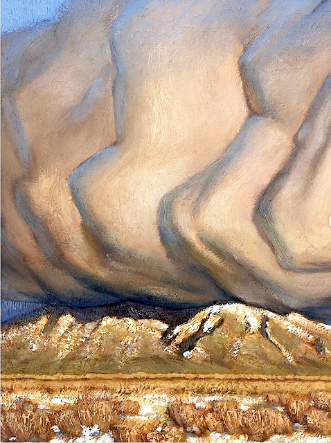
TAOS MOUNTAINS (PICURIS) PAINTED BY NATHANAEL VOLCKENING


NATHANAEL VOLKENING  Picuris Mountains (2,967 m - 9,734 ft) United States of America (New Mexico) In Winer bloom, oil on silk, 14 x 11cm, Taos Studio Society.


NATHANAEL VOLKENING
Picuris Mountains (2,967 m - 9,734 ft)
United States of America (New Mexico)

In Winer bloom, oil on silk, 14 x 11cm, Taos Studio Society.


The mountains
Picuris Mountains (2,967 m - 9,734 feet) is one of the Ridge in Taos County, nearby Osha Canyon and Vallecitos. Named Pikuria – those who paint – by Spanish colonizer Juan de Oñate, Picuris is located 24 miles (38 km) southeast of Taos in the Sangre de Cristo Mountains via N.M. 68, 518, and 75. Picuris, once the largest, today is one of the smallest Tiwa pueblos, with some 1,801 inhabitants (Census 2000). Like Taos, it was influenced by Plains Indian culture, particularly the Apaches
If one like biking, the ride takes you into the scenic and historic part of Picuris Mountains. About 2 miles from the start of this ride you will cross the historic Camino Real, or “Royal Highway,” that served as the original highway to Taos for traders, settlers, and Native Americans traveling north and south for several hundred years.
In late spring through fall this ride is free of snow and dry. It can be pretty beastly pushing up this mountain in the middle of summer. Plan on riding early or late in the day to avoid the heat.

_______________________________

2022 - Wandering Vertexes / Mountain paintings
By Francis Rousseau

Saturday, April 23, 2022

THE MONT BLANC PAINTED BY CESARE MAGGI


CESARE MAGGI (1881-1962), The Mont Blanc (4,808.73 m -15,777 ft) France - Italy  In " Alla montagne, il Monte Biancho", fuile sur toile, détail.

CESARE MAGGI (1881-1962),
The Mont Blanc (4,808.73 m -15,777 ft)
France - Italy

In " Alla montagne, il Monte Biancho", oil on canvas 


The painter
The italian painter Cesare Maggi was born into a family of actors, Maggi embarked on classical studies at his father’s wish but also took up painting at a very early age His debut in Florence at the Esposizione Annuale della Società di Belle Arti di Firenze in 1898 was followed by a short trip to Paris to catch up with the latest developments.
The crucial turning point in Maggi’s art came in 1889 with the posthumous show of work by Giovanni Segantini held by the Milanese Society of Fine Arts, which prompted a definitive shift to landscape painting of a Divisionist character. After a short stay in the Engadin, he returned to Milan before finally settling in Turin. Commercial collaboration with Alberto Grubicy until 1913 enabled Maggi to establish himself quickly as one of the leading representatives of the second generation of Divisionist painters in Italy. He painted a repertoire of readily comprehensible mountain landscapes focusing primarily on aspects of the visual perception of the reflection of light and colour but lacking the deep spirituality of Segantini’s work. He took part in the major Italian and European exhibitions and the Venice Biennale devoted an entire room to his work at the Esposizione Internazionale d’Arte of Venice in 1912. After an interlude devoted to portrait painting in the same decade, the artist’s mature work focused on greater simplification of subject matter, mostly in landscapes.
Maggi obtained the chair in painting at the Albertina Academy, Turin, in 1936.


The mountain

The Mont-Blanc (in French) (4 ,808.73 m -15,777 ft) or Monte Bianco (in Italian), both meaning "White Mountain", is the highest mountain in the Alps and the highest in Europe after the Caucasus peaks. It is ranked 11th in the world in topographic prominence. The Mont Blanc is one of the Seven Summit, which includes the highest mountains of each of the seven continents. Summiting all of them is regarded as a mountaineering challenge, first achieved on April 30, 1985 by Richard Bass. The 7 highest summit, (which are obviously 8 with 2 in Europe !) are : Mount Everest (8,848m), Aconcagua (6,961m), Mt Denali or Mc Kinley (6,194m), Kilimandjaro (5,895m), Mt Elbrus (5,642m), Mount Vinson (4,892m) and Mount Kosciuszko (2,228m) in Australia.
The mountain lies in a range called the Graian Alps, between the regions of Aosta Valley, Italy, and Savoie and Haute-Savoie, France. The location of the summit is on the watershed line between the valleys of Ferret and Veny in Italy and the valleys of Montjoie, and Arve in France. The Mont Blanc massif is popular for mountaineering, hiking, skiing, and snowboarding.
The three towns and their communes which surround Mont Blanc are Courmayeur in Aosta Valley, Italy, and Saint-Gervais-les-Bains and Chamonix in Haute-Savoie, France. A cable car ascends and crosses the mountain range from Courmayeur to Chamonix, through the Col du Géant. Constructed beginning in 1957 and completed in 1965, the 11.6 km (7¼ mi) Mont Blanc Tunnel runs beneath the mountain between these two countries and is one of the major trans-Alpine transport routes.
Since the French Revolution, the issue of the ownership of the summit has been debated.
From 1416 to 1792, the entire mountain was within the Duchy of Savoy. In 1723 the Duke of Savoy, Victor Amadeus II, acquired the Kingdom of Sardinia. The resulting state of Sardinia was to become preeminent in the Italian unification.[ In September 1792, the French revolutionary Army of the Alps under Anne-Pierre de Montesquiou-Fézensac seized Savoy without much resistance and created a department of the Mont-Blanc. In a treaty of 15 May 1796, Victor Amadeus III of Sardinia was forced to cede Savoy and Nice to France. In article 4 of this treaty it says: "The border between the Sardinian kingdom and the departments of the French Republic will be established on a line determined by the most advanced points on the Piedmont side, of the summits, peaks of mountains and other locations subsequently mentioned, as well as the intermediary peaks, knowing: starting from the point where the borders of Faucigny, the Duchy of Aoust and the Valais, to the extremity of the glaciers or Monts-Maudits: first the peaks or plateaus of the Alps, to the rising edge of the Col-Mayor". This act further states that the border should be visible from the town of Chamonix and Courmayeur. However, neither the peak of the Mont Blanc is visible from Courmayeur nor the peak of the Mont Blanc de Courmayeur is visible from Chamonix because part of the mountains lower down obscure them. A Sardinian Atlas map of 1869 showing the summit lying two thirds in Italy and one third in France.
After the Napoleonic Wars, the Congress of Vienna restored the King of Sardinia in Savoy, Nice and Piedmont, his traditional territories, overruling the 1796 Treaty of Paris. Forty-five years later, after the Second Italian War of Independence, it was replaced by a new legal act. This act was signed in Turin on 24 March 1860 by Napoleon III and Victor Emmanuel II of Savoy, and deals with the annexation of Savoy (following the French neutrality for the plebiscites held in Tuscany and Emilia-Romagna to join the Kingdom of Sardinia, against the Pope's will). A demarcation agreement, signed on 7 March 1861, defines the new border. With the formation of Italy, for the first time Mont Blanc is located on the border of France and Italy.
The 1860 act and attached maps are still legally valid for both the French and Italian governments. One of the prints from the 1823 Sarde Atlas positions the border exactly on the summit edge of the mountain (and measures it to be 4,804 m (15,761 ft) high). The convention of 7 March 1861 recognises this through an attached map, taking into consideration the limits of the massif, and drawing the border on the icecap of Mont Blanc, making it both French and Italian.Watershed analysis of modern topographic mapping not only places the main summit on the border, but also suggests that the border should follow a line northwards from the main summit towards Mont Maudit, leaving the southeast ridge to Mont Blanc de Courmayeur wholly within Italy.
Although the Franco-Italian border was redefined in both 1947 and 1963, the commission made up of both Italians and French ignored the Mont Blanc issue. In the early 21st century, administration of the mountain is shared between the Italian town of Courmayeur and the French town of Saint-Gervais-les-Bains, although the larger part of the mountain lies within the commune of the latter.

___________________________________________
2022- Wandering Vertexes...
by Francis Rousseau

Wednesday, April 20, 2022

LE ROCHER DES DEUX TROUS PAINTED BY VINCENT VAN GOGH


VINCENT VAN GOGH (1853-1890) Le Rocher des Deux Trous (348m - France (Provence)


VINCENT VAN GOGH (1853-1890)
Le Rocher des Deux Trous (348m - 1,141 ft)
France (Provence)


The hill
The Rocher des Deux Trous (348m) in the Alpilles massif is one of the most popular hikes for walkers, satrting from Saint-Remy de Provence. It offers a 360° panorama over the two slopes of the Alpilles and over the entire surrounding region, from Mont Ventoux to the north and as far as the Mediterranean Sea to the south, on a clear day. This picturesque rock eroded and sculpted by the North wind (the Mistral) was painted by Van Gogh during his stay in Saint-Paul de Mausole from May 1889 to May 1890.

The painter
Vincent Willem van Gogh was a Dutch Post-Impressionist painter who is among the most famous and influential figures in the history of Western art. In just over a decade he created about 2100 artworks, including around 860 oil paintings, most of them in the last two years of his life. They include landscapes, still lifes, portraits and self-portraits, and are characterized by bold, symbolic colours, and dramatic, impulsive and expressive brushwork that contributed to the foundations of modern art. He died by suicide at 37, following years of mental illness and poverty.
Born into an upper-middle-class family, Van Gogh drew as a child and was serious, quiet and thoughtful. As a young man he worked as an art dealer, often travelling, but became depressed after he was transferred to London. He turned to religion, and spent time as a missionary in southern Belgium. Later he drifted in ill health and solitude. He took up painting in 1881 having moved back home with his parents. His younger brother Theo supported him financially, and the two kept up a long correspondence by letter.
More about Vincent Van Gogh

_______________________________

2022 - Wandering Vertexes...
by Francis Rousseau

Sunday, April 17, 2022

GULA MONS (ON VENUS) BY NASA MAGELLAN MISSION


NASA MAGELLAN MISSION (1989-1994) Gula Mons (3000m/3km -9,843ft/1.9mi) Planet Venus (Solar system /The Milky Way Galaxy)

NASA MAGELLAN MISSION (1989-1994)
Gula Mons (3000m/3km -9,843ft/1.9mi)
Planet Venus (Solar system /The Milky Way Galaxy)


The mountain
Gula Mons (3000m/3km -9,843ft/1.9mi high and 276km diameter), named after the Mesopotamian Goddess of Healing, is a shield volcano on planet Venus in western Eistla Regio, located south of Sedna Planitia, west of Bereghinya Planitia and east of Guinervere Planitia, at 21,9° N et 359,1° E.
Its main feature is a NE-SW-oriented rift-like fracture set connecting two summit calderas. There is also a structure which links the northern caldera and ridge system to Idem Kuva corona located NW of Gula Mons. Radially spreading lava flows which have digitate and broad sheet-like forms extend from the summit, including radar-dark flows which overlay several older lava deposits. Radial and circumferential fractures are present on the flanks.

The image capturer
Gula Mons is displayed in this computer-simulated view of the surface of Venus. The viewpoint is located 110 kilometers (68 miles) southwest of Gula Mons at the same elevation as the summit, 3 kilometers (1.9 miles) above Eistla Regio. Lava flows extend for hundreds of kilometers across the fractured plains. The view is to the northeast with Gula Mons appearing at the center of the image. Gula Mons, a 3 kilometer (1.9 mile) high volcano, is located at approximately 22 degrees north latitude, 359 degrees east longitude in western Eistla Regio. Magellan synthetic aperture radar data is combined with radar altimetry to produce a three-dimensional map of the surface. Rays cast in a computer intersect the surface to create a three-dimensional perspective view. Simulated color and a digital elevation map developed by the U.S. Geological Survey are used to enhance small-scale structure. The simulated hues are based on color images recorded by the Soviet Venera 13 and 14 spacecraft. The image was produced by the JPL Multimission Image Processing Laboratory and is a single frame from a video released at the March 5, 1991, JPL news conference.  
- More about NASA Magellan Mission 

 
___________________________________________
2022 - Wandering Vertexes...
by Francis Rousseau

Friday, April 15, 2022

NAANU-I-CAKE PAINTED BY CONSTANCE GORDON-CUMMING (1837–1924)


CONSTANCE GORDON-CUMMING (1837–1924) Naanu-i-Cake (no elevation data) Fiji

CONSTANCE GORDON-CUMMING (1837–1924)
Naanu-i-Cake (no elevation data)
Fiji

In "Nananu, Fiji ", watercolor 28.5 x 42 cm

The volcano
Naanu-i-Cake  (no elevation data) is a volcanic island in Fiji less than one kilometer off the coast of the main island of Viti Levu, near the Rakiraki-district in Ra Province. Nananu-i-Cake is located immediately next to the island of Nananu-i-Ra. Nananu-i-Cake and Mabua (the islet located immediately to the southeast) islands are about 600 acres (242.81 hectares) in area. The main residence on the island was designed by the architecture firm of Murray Cockburn, based in Auckland.  A deep-water jetty is on the island's western shore.  In 1974, Sir Harold Mitchell visited Fiji from the UK and purchased Nananu-i-Cake and Mabua as a retreat. Because of Harold's position of Vice-Chairman of the Conservative Party under Sir Winston Churchill and his social and political standing, several high-profile dignitaries visited and stayed on the island. Commemorative trees were planted for many of these high-profile visits. Nananu-i-Cake has remained in Sir Harold Mitchell's family since 1974.  Nananu-i-Cake also retains evidence of moka, stone formations built in tidal areas to trap fish at low tide, and ring-wall fortifications built with volcanic rocks. As of 2012, the entire island is tentatively available for sale as a private island, for an estimated equivalent of around $8-8.5 million USD. In early 2022 the island received renewed attention on social media as self-proclaimed crypto-enthustiasts Max Olivier and Helena López Jurado announced plans to purchase the Nananu-i-Cake and build a private resort aimed at other crypto-enthusiasts using money raised from selling NFTs tied to property on the island to prospective residents.

The painter
Constance Frederica “Eka” Gordon-Cumming was a noted Scottish travel writer and painter. Born in a wealthy family, she travelled around the world and painted described scenes and life as she saw them.
Constance Gordon-Cumming was a prolific landscape painter, mostly in Asia and the Pacific. She painted over a thousand watercolors and worked with a motto to ‘never a day without at least one careful-coloured sketch’ starting her day at 5 am while in India. Places she visited include Australia, New Zealand, America, China, and Japan.
She arrived in Hilo, Hawaii in October 1879, and was among the first artists to paint the active volcanoes. Her Hawaii travelogue, Fire Fountains: The Kingdom of Hawaii, was published in Edinburgh in 1883. She had several dangerous moments but her travel ended in 1880 when the Montana that she was on ran into rocks at Holyhead. While most of the passengers took the lifeboat, she stayed on last along with the captain to save her paintings and was rescued many hours later. She returned to live at Crieff with her widowed sister Eleanor and continued to write books.
Her best known books are At Home in Fiji and A Lady's Cruise on a French Man-of-War. The latter book resulted from an invitation to join a French ship put into service for the Bishop of Samoa so that he could visit remote parts of his far-flung diocese.
Miss Gordon-Cumming received much criticism from male writers of the era, perhaps because she did not fit in the traditional Victorian role of women, as she often traveled alone and unaided.
In any case, her landscape drawings and watercolors seem to be universally admired.

___________________________________________
2022 - Wandering Vertexes...
by Francis Rousseau