google.com, pub-0288379932320714, DIRECT, f08c47fec0942fa0 GRAVIR LES MONTAGNES... EN PEINTURE

Thursday, March 31, 2022

PICO DE ORIZABA / CILALTÉPETL PAINTED BY DIEGO RIVERA

DIEGO RIVERA (1886-1957) Pico de Orizaba / Citlaltépetl (5,636 m -18,491 ft)  Mexico (Vera Cruz)
 
DIEGO RIVERA (1886-1957)
Pico de Orizaba / Citlaltépetl (5,636 m -18,491 ft) 
Mexico (Vera Cruz)


The mountain
Pico de Orizaba (5,636 m -18,491 ft) also known as Citlaltépetl is a stratovolcano, the highest mountain in Mexico and the third highest in North America, after Denali of Alaska in the United States and Mount Logan of Canada. It rises in the eastern end of the Trans-Mexican Volcanic Belt, on the border between the states of Veracruz and Puebla. The volcano is currently dormant but not extinct, with the last eruption taking place during the 19th century. It is the second most prominent volcanic peak in the world after Africa's Mount Kilimanjaro. Pico de Orizaba was important in pre-Hispanic cultures, such as those of the Nahuatl-speaking Aztecs and the Totonacs. The volcano is part of many native mythologies. Pico de Orizaba is located 200 kilometres (120 mi) east of Mexico City and approximately 480 kilometres (300 mi) south of the Tropic of Cancer. A companion peak lying about six km to the southwest of Pico de Orizaba is the Sierra Negra, at 4,640 metres (15,223 ft). Pico de Orizaba is one of only three volcanoes in México that continue to support glaciers and is home to the largest glacier in Mexico, Gran Glaciar Norte. Orizaba has nine known glaciers: Gran Glaciar Norte, Lengua del Chichimeco, Jamapa, Toro, Glaciar de la Barba, Noroccidental, Occidental, Suroccidental, and Oriental. Pico de Orizaba, like the Sierra Madre Oriental, forms a barrier between the coastal plains of the Gulf of Mexico and the Mexican Plateau. The volcano blocks the moisture from the Gulf of Mexico from saturating central Mexico and influences the climates of both areas. Both the state of Veracruz and Puebla depend on Pico de Orizaba for supplying fresh water. The largest river originating on the volcano is the Jamapa River.

The painter
Diego María de la Concepción Juan Nepomuceno Estanislao de la Rivera y Barrientos Acosta y Rodríguez, known as Diego Rivera was a prominent Mexican painter. His large frescoes helped establish the Mexican mural movement in Mexican art. Between 1922 and 1953, Rivera painted murals in, among other places, Mexico City, Chapingo, Cuernavaca, San Francisco, Detroit, and New York City. In 1931, a retrospective exhibition of his works was held at the Museum of Modern Art in New York. Rivera had a volatile marriage with fellow Mexican artist Frida Kahlo. In 1926, Rivera became a member of AMORC, the Ancient Mystical Order Rosae Crucis, an occult organization founded by American occultist Harvey Spencer Lewis. In 1926, Rivera was among the founders of AMORC's Mexico City lodge, called Quetzalcoatl, and painted an image of Quetzalcoatl for the local temple. In 1954, when he tried to be readmitted into the Mexican Communist Party from which he had previously been excluded because of his support of Trotsky, Rivera had to justify his AMORC activities. The Mexican Communist Party at that time excluded from its ranks members of Freemasonry, and regarded AMORC as suspiciously similar to Freemasonry. Rivera answered that, by joining AMORC, he wanted to infiltrate a typical “Yankee” organization on behalf of Communism. However, he also claimed that AMORC was “essentially materialist, insofar as it only admits different states of energy and matter, and is based on ancient Egyptian occult knowledge from Amenhotep IV and Nefertiti.”
___________________________________________ 


2022 - Wandering Vertexes...
by Francis Rousseau

Monday, March 28, 2022

EL CAPITAN PAINTED BY WAYNE THIEBAUD


WAYNE THIEBAUD (1920-2021),El Capitan (2,309m - 7,573 ft), United States of America, In" Mount and Cloud", 1972, oil on canvas 20 1/4 x 22 in

WAYNE THIEBAUD (1920-2021)
El Capitan (2,309m - 7,573 ft)
United States of America

 In Mount and Cloud, 1972, oil on canvas 20 1/4 x 22 in.

 
The painter
Morton Wayne Thiebaud was an American painter known for his colorful works depicting commonplace objects—pies, lipsticks, paint cans, ice cream cones, pastries, and hot dogs—as well as for his landscapes and figure paintings. Thiebaud is associated with the pop art movement because of his interest in objects of mass culture, although his early works, executed during the fifties and sixties, predate the works of the classic pop artists. Thiebaud used heavy pigment and exaggerated colors to depict his subjects, and the well-defined shadows characteristic of advertisements are almost always included in his work.
Thiebaud was averse to labels such as "fine art" versus "commercial art" and described himself as "just an old-fashioned painter". He disliked Andy Warhol's "flat" and "mechanical" paintings and did not consider himself a pop artist.
In addition to pastries, Thiebaud painted characters such as Mickey Mouse as well as landscapes, streetscapes, and cityscapes, which were influenced by the work of Richard Diebenkorn. His paintings such as Sunset Streets (1985) and Flatland River (1997) are noted for their hyper realism, and have been compared to Edward Hopper's work, another artist who was fascinated with mundane scenes from everyday American life.
In 1962, Thiebaud's work was included, along with Roy Lichtenstein, Andy Warhol, Jim Dine, and Robert Dowd, in the historically important and ground-breaking "New Painting of Common Objects" curated at the Pasadena Art Museum.  This exhibition is considered to have been one of the first Pop Art exhibitions in the United States. These painters were part of a new movement, in a time of social unrest, which shocked the U.S. and the art world.

The mountain
El Capitan (2,309m - 7,573 ft) is a vertical rock formation in Yosemite National Park, located on the north side of Yosemite Valley, near its western end. The granite monolith extends about 3,000 feet (900 m) from base to summit along its tallest face and is one of the world's favorite challenges for rock climbers.
The formation was named "El Capitan" by the Mariposa Battalion when it explored the valley in 1851. El Capitan ("the captain") was taken to be a loose Spanish translation of the local Native American name for the cliff, variously transcribed as "To-to-kon oo-lah" or "To-tock-ah-noo-lah".
It is unclear if the Native American name referred to a specific tribal chief or simply meant "the chief" or "rock chief". In modern times, the formation's name is often contracted to "El Cap", especially among rock climbers and BASE jumpers.
The top of El Capitan can be reached by hiking out of Yosemite Valley on the trail next to Yosemite Falls, then proceeding west. For climbers, the challenge is to climb up the sheer granite face. There are many named climbing routes, all of them arduous, including Iron Hawk and Sea of Dreams, for example.
The Nose was first climbed in 1958 by Warren Harding, Wayne Merry and George Whitmore in 47 days using "siege" tactics: climbing in an expedition style using fixed ropes along the length of the route, linking established camps along the way.
In September 1973, Beverly Johnson and Sibylle Hechtel were the first team of women to ascend El Capitan via the Triple Direct route.

_______________________________


2022 - Wandering Vertexes...
by Francis Rousseau

Friday, March 25, 2022

MOUNT LISTER & MOUNT HOOKER PAINTED BY DAVID ROSENTHAL


DAVID ROSENTHAL (bn. 1953) Mount Lister ( 4,025m- 13, 200ft) Antarctica (Victoria Land)

DAVID ROSENTHAL (bn. 1953)
Mount Lister  ( 4,025m- 13, 200ft)
Mount Hooker ( 3, 800m - 12, 500 ft)
Antarctica (Victoria Land)


The mountain
Mount Lister is a massive mountain,forming the highest point in the Royal Society Range of Victoria Land, Antarctica. It was discovered by the British National Antarctic Expedition (1901–1904) which named it for Lord Joseph Lister, President of the Royal Society, 1895–1900. Waikato Spur, a rock spur about 3 nmi (5.6 km) long, extends northwestward from Mount Lister. The spur separates the upper part of Emmanuel Glacier from the Carleton Glacier. The spur was named by the US Advisory Committee on Antarctic Names (US-ACAN) in 1994 after the University of Waikato in Hamilton, New Zealand, in association with nearby features that are named after colleges and universities. 

Mount Hooker standing immediately south of Mount Lister in the Royal Society Range of Victoria Land, Antarctica. It was discovered by the British National Antarctic Expedition, 1901–04, which named it for Sir Joseph Dalton Hooker.


The Painter
David Rosenthal is known as one of the best Antarctic Painter, Painter of Ice, Arctic Artist, Alaskan Artist and an Extreme Artist. He has been lured to cold climates regularly to record snow, ice, and landscapes. Davids paintings of glaciers and icebergs are astoundingly realistic and at the same ethereal at the same time. However his work also includes much more than ice, icebergs and glaciers... Cordova, Alaska is the place David Rosenthal calls home. As an artist and art teacher David has taught and continues to teach many students in Alaska. While teaching art in Alaska, David has instructed students and artist in many programs including the Alaska Artists in the Schools Program, Prince William Sound Community College and University of Alaska Fairbanks Summer Sessions. Alaskan artist David Rosenthal makes it a priority to travel around Alaska as much as possible to continue to capture the incredible beauty in his artwork of Alaska.
Having spent over sixty months on the Ice, including four austral winters and six austral summers, David became an Antarctic artist and has created art images from a large variety of places in every season. David has completed paintings of the antarctic landscape from all across Antarctica. Time in Antarctica included travel as a participant in the National Science Foundation Antarctic Artists and Writers Program during a summer and a winter at McMurdo Station as well as most of a winter at Palmer Station. David has also worked for the NSF contractor for two winters and four summers in various job capacities as a way to spend time and become familiar with the landscape.
Rosenthal's work also includes many water colors, oil paintings, sketches and small studies. The paintings seem to magically reflect the intensity of nature's colors and the atmospheric phenomena that David witnesses. David really is a master of Extreme Art!

_______________________________
2022 - Wandering Vertexes...
by Francis Rousseau

Tuesday, March 22, 2022

THE MER DE GLACE AND GRAND CHARMOZ PAINTED BY GABRIEL LOPPÉ


GABRIEL LOPPÉ (1825-1913), Les Aiguilles du Grand Charmoz (3,445m - 11,302ft) France  In La Mer de Glace et les Grands Charmoz, Chamonix, Huile sur toile, Courtesy JohnMitchell Fine Arts, London, Artcurial Paris,

GABRIEL LOPPÉ (1825-1913),
Les Aiguilles du Grand Charmoz (3,445m -11,302ft)
France

In La Mer de Glace et les Grands Charmoz, Chamonix, Huile sur toile, 

Courtesy John Mitchell Fine Arts, London, and Artcurial Paris,

 
The painter

Toussaint Gabriel Loppé was a French painter, photographer and mountaineer. He became the first foreigner to be made a member of the Alpine Club in London. His father was a captain in the French Engineers and Loppé's childhood was spent in many different towns in south-eastern France. Aged twenty-one Loppé climbed a small mountain in the Languedoc and found a group of painters sketching on the summit. He had found his calling and subsequently went off to Geneva where he met the reputed leading Swiss landscapist, Alexandre Calame (1810 -1864). Loppé took up mountaineering in Grindelwald in the 1850s and made friends easily with the many English climbers in France and Switzerland. Although he was frequently labelled as a pupil of Calame and his rival François Diday, Loppé was almost an entirely self-taught artist. He became the first painter to work at higher altitudes during climbing expeditions earning the right to be considered the founder of the peintres-alpinistes school, which became established in the Savoie at the turn of the nineteenth century.
Notable followers of Loppé include, Charles Henri Contencin (1875-1955) and Jacques Fourcy (1906-1990). Together with the first ascent of Mt Mallet in Chamonix’s Grandes Jorasses range, Loppé made over 40 ascents of Mont Blanc during his climbing career, which lasted until the late 1890s. He frequently made oil sketches from alpine summits, including a panorama of the view from the summit of Mont Blanc.
His paintings became celebrated for their atmosphere and spontaneity and he soon found himself taking part in many exhibitions in London and in Paris.
By 1896 Loppé had spent over fifty seasons climbing and painting in Chamonix. As the valley’s unrivalled ‘Court painter’ his work was in constant demand with the majority of his pictures going to English climbers and summer tourists.
In his later years, Loppé became fascinated with photography and was quite an innovator in this field too. His long exposure photograph of the Eiffel Tower struck by lightning, now in the Musée d'Orsay in Paris remains one of his iconic images. 

 
The mountain
The Aiguille des Grands Charmoz (3,445 m), is one of the Chamonix needles in the Mont Blanc massif. It is made up of a ridge bristling with " gendarmes", including La Carrée, and Bâton Wicks. The first ascent was done on August 9, 1885 by H. Dunod and P. Vignon with the guides J. Desailloux, F. Folliguet, F. and G. Simond, by the corridor Charmoz-Grépon. It is today the normal way of descent, the climb generally being made by the south-west slope and the northwestern edge (AD +), climbed 15 July 1880 by Albert F. Mummery with Alexandre Burgener and Benedikt Venetz, which stopped before the summit at point 3 435 m. The Aiguille des Grands Charmoz is linked with the Aiguille du Grépon for the crossing of Charmoz-Grépon (D), one of the great rocky classics of the Mont Blanc massif. The first crossing was done by Laurent Croux in 1904. The first ascent of the north face, via the needle of the Republic, and crossing the edges of the Charmoz was done by Raymond Leininger and G. Bicavelle in 1946. In 1974, Jean-Claude Droyer succeeded the solo climb of the western pillar of the Grand Charmoz (Cordier lane opened in 1970 by Patrick Cordier).
The Mt Blanc is one of the 7 highest summits in earth, (which are obviously 8 with 2 in Europe !):
Mount Everest (8,848m), Aconcagua (6,961m), Mt Denali or Mc Kinley (6,194m), Kilimandjaro (5,895m), Mt Elbrus (5,642m), Mount Vinson (4,892m) and Mount Kosciuszko (2,228m) in Australia.

The Glacier
The Mer de Glace (Sea of Ice) is an alpine valley glacier located on the northern slope of the Mont-Blanc massif. It is formed by the confluence of the Tacul glacier and the Leschaux glacier and flows into the Arve valley, on the territory of the municipality of Chamonix-Mont-Blanc, giving rise to the Arveyron. The glacier is seven kilometers long, its supply basin has a maximum length of twelve kilometers and an area of ​​40 km2, while its thickness reaches 300 meters. In the middle of the 20th century, an ice cave was pierced for the first time in the Mer de Glace. Due to the attraction's success, a cable car was put into service in 1961 to access it, then replaced by a cable car in 1988. Since 1973, an underground hydroelectric power station has been using the meltwater from the glacier.
Almost a million visitors go to Montenvers every year to contemplate the Mer de Glace. During peak periods, half of them visit the ice cave. Three museums are also located on the site. Skiing is possible from the Aiguille du Midi in winter. However, the retreat of the glacier, measured since 1860-1870, causes a loss of thickness of 120 meters in a century in its terminal part. It causes difficulties at the level of the ice cave, where more and more steps are necessary to reach the gondola, and requires considering its upstream movement, like the catchment of the hydroelectric power station in 2011.
_______________________________
2022 - Wandering Vertexes...
by Francis Rousseau


Saturday, March 19, 2022

MONT AGEL PAINTED BY CLAUDE MONET


CLAUDE MONET (1840-1926) Mont Agel (1,151m - 3,776 ft) France - Monaco border  In Cap Martin près de Menton, Huile sur toile, 1884  65 x 82cm, Private Collection


CLAUDE MONET (1840-1926)
Mont Agel (1,151m - 3,776 ft)
France - Monaco border

In Cap Martin près de Menton, Huile sur toile, 1884  65 x 82cm, Private Collection 


About this painting
Another painting was done by Monet exactly  in the same place but at a different time of day. It has already been published in this blog. Colors and  general impression are totally different. One can compare the two paintings. this one is supposed to have been painted at 10 a.m, the other à 6 p.m. Monet, like the japanese painters ,and particularly Hokusai who painted the 36 views of Mount Fuji, reproduced the same artistic behavior by painting series of the same mountains, in the same place, at different hours of the day or different seasons. At Cap Martin and Mont Agel, Monet painted about ten of them.

 The mountain
Mont Agel (1,151m - 3,776 ft) is a summit of the Alps located in the South of France, overlooking part of the French Riviera, Monaco, Beausoleil, Roquebrune-Cap-Martin... exactly as shwon in the Monet's painting above !
It has held a historic strategic position since Antiquity and still houses military aerial detection installations today. Mount Agel is precisely located in the French commune of Peille, ( Provence-Alpes-Côte d'Azur region). It rises in the Prealps of Nice and constitutes the highest point of the Monegasque watershed. The highest point of the principality, of Monaco, on the slopes of this mountain, can be reached by the Chemin des Révoires. A massive summit, Mount Agel is visible from a great distance: from certain districts of Nice as well as from a large part of the French Riviera between Cannes, Antibes, Nice, Antibes, and the Principality of Monaco and likewise from the Italian Riviera to around Vintimiglia and Bordighiera.
The history of Mount Agel begins with the Celto-Ligurian tribes who occupied the site and some of whose members were involved in the boarding and looting of boats engaged in cabotage. They are submitted from 23 to 13 BC. BC by the Romans who restored the old coastal route passing through the slopes of Mount Agel to link Ventimiglia to Narbonne Gaul and forming part of the Via Aurelia.
From 1931, new elements of fortification were built within the framework of the Maginot line.
Mount Agel now houses a large work of artillery equipped with turrets, linked together by deeply buried galleries. During the fighting of June 1940, his shots participated in the defense of Menton and supported the outpost of Pont-Saint-Louis and the work of Cap-Martin.
Until 2012, the 943 Capitaine Auber air base of the French Air Force was located there.
Today, only radars remain, which continue their watch in automatic mode, the information being transmitted and used by the Detection and Control Center at 942 Lyon-Mont Verdun air base.
Mount Agel also shelters on its slopes, the Monte-Carlo Golf Club, a very selective club. A little to the east of the golf course is the transmitter center of Fontbonne. Until its recent redevelopment, there were various protohistoric constructions.
Close to Mount Agel and the golf course is also the summer residence of Princes of Monaco (Rocagel site).


The painter
The painter Oscar-Claude Monet better known as Claude Monet was a founder of French Impressionist painting, and the most consistent and prolific practitioner of the movement's philosophy of expressing one's perceptions before nature, especially as applied to plein-air landscape painting. The term "Impressionism" is derived from the title of his painting « Impression, soleil levant » (Impression, Sunrise), which was exhibited in 1874 in the first of the independent exhibitions mounted by Monet and his associates as an alternative to the Salon de Paris.
Monet's ambition of documenting the French countryside led him to adopt a method of painting the same scene many times in order to capture the changing of light and the passing of the seasons exactly like the japanese artist Hokusai (1760-1849) did with his 36 views of Mount Fuji.
Monet repeated this kinf of "exercise de stylee with his series on Les Petites Dalles. and Kolsass mountain.
Monet has been described as "the driving force behind Impressionism". Crucial to the art of the Impressionist painters was the understanding of the effects of light on the local colour of objects, and the effects of the juxtaposition of colours with each other. Monet's long career as a painter was spent in the pursuit of this aim.
In 1856, his chance meeting with Eugene Boudin, a painter of small beach scenes, opened his eyes to the possibility of plein-air painting. From that time, with a short interruption for military service, he dedicated himself to searching for new and improved methods of painterly expression. To this end, as a young man, he visited the Paris Salon and familiarised himself with the works of older painters, and made friends with other young artists.[54] The five years that he spent at Argenteuil, spending much time on the River Seine in a little floating studio, were formative in his study of the effects of light and reflections. He began to think in terms of colours and shapes rather than scenes and objects. He used bright colours in dabs and dashes and squiggles of paint. Having rejected the academic teachings of Gleyre's studio, he freed himself from theory, saying "I like to paint as a bird sings."
In 1877 a series of paintings at Gare St-Lazare had Monet looking at smoke and steam and the way that they affected colour and visibility, being sometimes opaque and sometimes translucent. He was to further use this study in the painting of the effects of mist and rain on the landscape. The study of the effects of atmosphere were to evolve into a number of series of paintings in which Monet repeatedly painted the same subject in different lights, at different hours of the day, and through the changes of weather and season. This process began in the 1880s and continued until the end of his life in 1926.
His first series exhibited as such was of Haystacks, painted from different points of view and at different times of the day. Fifteen of the paintings were exhibited at the Galerie Durand-Ruel in 1891. In 1892 he produced what is probably his best-known series, Twenty-six views of Rouen Cathedral. In these paintings Monet broke with painterly traditions by cropping the subject so that only a portion of the facade is seen on the canvas. The paintings do not focus on the grand Medieval building, but on the play of light and shade across its surface, transforming the solid masonry.
Other series include Peupliers, Matins sur la Seine, and the Nenuphars that were painted on his property at Giverny. Between 1883 and 1908, Monet traveled to the Mediterranean, where he painted landmarks, landscapes, and seascapes, including a series of paintings in Antibes (above) and Venice. In London he painted four series: the Houses of Parliament, London ; Charing Cross Bridge ; Waterloo Bridge, and Views of Westminster Bridge. Helen Gardner writes: "Monet, with a scientific precision, has given us an unparalleled and unexcelled record of the passing of time as seen in the movement of light over identical forms."
___________________________________________

2022 - Wandering Vertexes...
by Francis Rousseau

Wednesday, March 16, 2022

THE SIMPLON PASS BY ANONYMOUS FRENCH PAINTER

19TH CENTURY' FRENCH SCHOOL OF PAINTING Col du Simplon (2,005 m - 6,578 ft) Switzerland  In  "Le passage des Alpes par l'armée napoléonienne",   Huile sur toile, non rentoilée, ca. 1806,   64,5 x 77 cm  Private collection

 ANONYMOUS FRENCH PAINTER
Col du Simplon (2,005 m - 6,578 ft)
Switzerland

In  "Le passage des Alpes par l'armée napoléonienne",   Huile sur toile, non rentoilée, ca. 1806,            64,5 x 77 cm  Private collection  

 
About the painting
This historical painting tells how and above all where the army of Napoleon 1st crossed the Alps to enter Italy, at the Simplon Pass (Col du Simplon). The road was built between 1801 and 1805 by the engineer Nicolas Céard, on the orders of Napoleon Bonaparte who wanted to open a passage for his artillery (described above); the cost was more than 8 million francs.  It was also Napoleon who, on February 21, 1801, without even consulting the canons of Saint-Bernard, decided to create a hospice in every way similar to that of the Col du Grand-Saint-Bernard, of which he had a lot appreciated the usefulness.  When Napoleon fell, only the first floor had been built. The building remained as it was until the mid-1820s, when work resumed and was completed in 1831.

The mountain pass
The Col du Simplon (2,005 m - 6,578 ft) (Simplon Pass in english) is a high mountain pass between the Pennine Alps and the Lepontine Alps in Switzerland. It connects Brig in the canton of Valais with Domodossola in Piedmont (Italy). The pass itself and the villages on each side of it, such as Gondo, are in Switzerland. The Simplon Tunnel was built beneath the vicinity of the pass in the early 20th century to carry rail traffic between the two countries.
The lowest point of the col (pass) and the lowest point on the watershed between the basins of the Rhone and the Po in Switzerland lies in marshland about 500 m - 1,640 ft west of the Simplon Pass settlement at an altitude of 1,994 m - 6,542 ft.
Rotelsee is a lake located near the pass at an elevation of 2,028 m (6,654 ft).
There are several great peaks around that can be climbed directly from the pass. These include Wasenhorn, Hubschhorn, Breithorn (Simplon), and Monte Leone.

The French school of painting in the 19th century
This term designates artworks produced in 19th-century France that reflects the teachings of the École des Beaux-Arts, the Parisian state-sponsored art academy.  Prioritizing draftsmanship over painting, the school taught students to employ fine line work and soft, blended shading in their drawings. Jean-Auguste-Dominique Ingres’s drawings, epitomize the Academic style, which is characterized by close attention to detail, near-invisible brushstrokes, and an emphasis on realistic modeling and shading. Academic painters often depicted scenes from history, literature, the Bible, or classical mythology, although this style can also be seen in pastoral scenes.

_______________________________

2022 - Wandering Vertexes...
by Francis Rousseau

Saturday, March 12, 2022

LE GRAND COMBIN PAINTED BY GUSTAVE DORÉ

GUSTAVE DORÉ (1832-1883) Le Grand Combin (4,314 m- 14, 154ft) Switzerland  In Le Grand Combin, Suisse romande, Oil on panel,  26 x 35 cm. Private collection (Christies)

GUSTAVE DORÉ (1832-1883)
Le Grand Combin (4,314 m- 14, 154ft)
Switzerland

In Le Grand Combin, Suisse romande, Oil on panel,  26 x 35 cm. Private collection (Christies)

The mountain
The Grand Combin is a mountain massif in the western Pennine Alps in Switzerland. With its 4,314 metres (14,154 ft) highest summit, the Combin de Grafeneire, it is one of the highest peaks in the Alps and the second most prominent of its range. The Grand Combin is also a large glaciated massif consisting of several summits, among which three are above 4000 metres:
- Combin de Grafeneire (4,314 m -14,154 ft),
- Combin de Valsorey (4,183 m -13,724 ft),
- Combin de la Tsessette (4,134 m -13,563 ft).
The massif of the Grand Combin lies south of Verbier between the Val d'Entremont (west) and Val de Bagnes (west). The north-western facing side of Grand Combin is entirely covered by eternal snows and glaciers which are prone to serac falls. The southern and eastern walls are more steep and thus exempt of snow.
The topography of the Grand Combin is intricate. Between the Val d'Entremont and the Val de Bagnes are two high ridges, nearly parallel to each other and to those valleys, which both diverge from a short transverse ridge of great height. The southern end of the space enclosed between these three ridges is an elevated plateau of great extent, where the snows accumulate and feed the Corbassière Glacier which descends thence for about ten kilometers to the north. The glacier is surrounded by the peaks of Petit Combin, Combin de Corbassière and Combin de Boveire on the west, Grand Tavé and Tournelon Blanc on the east. Smaller glaciers lie on the external flanks such as Boveire and Mont Durand Glacier.
The Grand Combin, which yields in height to only a few European mountains, was long one of the least known of Alpine summits. The first to commence the exploration of the great massif which separates the Val de Bagnes from the Val d'Entremont was Gottlieb Samuel Studer, of Berne, who on August 14, 1851 reached for the first time the summit of the Combin de Corbassière with the guide Joseph-Benjamin Fellay, and has published an account of that and a subsequent excursion in Bergund Gletscher-Fahrten. He was followed in that ascent five years later by W. and C. E. Mathews, and in 1857, William Mathews anticipated Studer in the ascent of the second peak of the Grand Combin.
The first four expeditions on Grand Combin reached only the minor summit east of Grand Combin (Aiguille du Croissant). The first one was made by mountain guides from the valley (Maurice Fellay and Jouvence Bruchez) on July 20, 1857. The first complete ascent of Grand Combin was finally made on July 30, 1859 by Charles Sainte-Claire Deville with Daniel, Emmanuel and Gaspard Balleys, and Basile Dorsaz.
The Grand Combin de Valsorey on the west was reached for the first time on 16 September 1872 by J. H. Isler and J. Gillioz. They climbed the south south face above the Plateau du Couloir. The itinerary on the south-east ridge was opened on 10 September 1891 by O. Glynne Jones, A.Bovier and P. Gaspoz.
The "Penitents", those reliefs of ice that one see rising on the surface of the glacier of the Grand Combin, in this 1787 painting, have all disappeared at the beginning of 21th century, because of global warming...


The painter
Paul-Gustave-Louis-Christophe Doré said Gustave Doré, born January 6, 1832 in Strasbourg and died January 23, 1883 in Paris in his house in the rue Saint-Dominique, is an illustrator, writer, cartoonist, painter and French sculptor. It has been internationally recognized in his lifetime.
In 1851, two albums Three artists misunderstood and unhappy and Des-approval for a pleasure trip are published at Aubert. Freed from the inspiration of Rudolf Töppfer and compliance executives, Gustave Doré performs freely arranged vignettes with several dimensions. The plurality of page composition, its innovations and graphic variants are deployed mainly in Des-approval for a pleasure trip. His technique uses the lithographic pencil, drawing directly on the stone.
Paul Lafon, writer and editor, he had met with Philipon, agreed to his request to illustrate the works of Rabelais. In 1854, the book is published by Bry with 99 vignettes and 14 inset plates engraved on wood. This affordable edition with low printing quality and modest size (large octavo) is not up to the high ambitions of Gustave Doré. In 1854 and 1873 shows two versions of "Rabelais Works" and in 1855: The Hundred Tales of comical by Honoré de Balzac.
In 1856 he illustrates with a painter's hand, The Wandering Jew, a poem set to music by Pierre Dupont, a work break in his artistic career and in the history of the woodcut. Abandoning copper engraving usually privileged, Gustave Doré chooses the color of wood technical (interpretation etching). Doré formed its own school burners. Each plank of the work, with a short caption end of the poem is a work of painting. The large format of the book allows the transition to movies folio. The image is independent of the text. This work is having great success with the public.
Gustave Doré wants to deploy his talent in illustration of the great works of literature, with contempt observed towards caricature and drawing current. It will list the thirty masterpieces in the epic, comic or tragic his ideal library wishing illustrate them in the same format as the Wandering Jew, Dante's Inferno, the Tales by Perrault, Don Quixote, Homer, Virgil, Aristotle, Milton (The lost paradise) or Shakespeare ... The publishers refuse to perform these luxury publications of too much cost. Gustave Doré should self-publish the works of Dante in 1861. The critical and popular success hails striking prints on the text. A critic will assert that: "The author is crushed by the designer. More than Dante illustrated by Doré, Doré is illustrated by Dante. "
In the 1860s, he illustrated the Bible.
He attended high society and expands his pictorial activities it consists of large paintings like Dante and Virgil in the ninth circle of Hell (1861 - 311 × 428 cm - Musée de Brou), The Enigma (Musée d'Orsay ) or the Christ leaving court (1867-1872 - 600 × 900 cm² Museum of modern and Contemporary Art of Strasbourg).
According to Ray Harryhausen, famous designer of special effects, multiplying together drawings and illustrations of all kinds (fantastic, portraits-loads), its reputation extends to Europe, he met a huge success in England with the Doré Gallery that opened in London in 1869. In 1875, the figure of Samuel Coleridge's poem The Rime of the Ancient Mariner (Lament of the Ancient Mariner) published in London by Golden Gallery is one of his greatest masterpieces.
His art of composition culminated in London, a Pilgrimage by Blanchard Jerrold, true story about the London of the late nineteenth century when all classes are present, inspiration is particularly striking in the description of the London slums.
He died of a heart attack at age 51 on January 23, 1883, leaving an impressive work of more than ten thousand pieces, which will have later a strong influence on many illustrators. His friend Ferdinand Foch organizes the funeral at St. Clotilde, burial at Père Lachaise and a farewell meal at 73 rue Saint-Dominique

_______________________________

2022 - Wandering Vertexes...
by Francis Rousseau

Wednesday, March 9, 2022

GIEWONT PAINTED BY ALEKSANDER KOTSIS


ALEKSANDER KOTSIS (1836-1877) Giewont Massif (1, 895 m- 6, 217 ft) Poland   In Giewont (oil on canvas, 39,5 x 55,5 cm, 1870, Muzeum Narodowe w Krakowie.


ALEKSANDER KOTSIS (1836-1877)
Giewont Massif (1, 895 m- 6, 217 ft)
Poland

 In Giewont (oil on canvas, 39,5 x 55,5 cm, 1870, Muzeum Narodowe w Krakowie.

 
The  painter
Aleksander Kotsis  was a Polish painter. He created landscapes, portraits, and genre scenes in a combination Romantic and Realistic style. Most of his paintings are small. He grew up just outside Kraków, where his family had a small farm. They moved into Kraków in 1846 to become merchants and he began his studies in 1850 at the Academy of Fine Arts with Wojciech Stattler and Władysław Łuszczkiewicz. His father was not supportive of his studies, so he had to continue working in their shop and taking his lessons intermittently. In 1857, he began exhibiting with the Society of Friends of Fine Arts.  Finally he sold some paintings and, with the assistance of Stattler, obtained a scholarship from the Ministry of Religion and Education which enabled him to enroll at the Academy of Fine Arts, Vienna, where he studied with Ferdinand Georg Waldmüller, among others. He returned to Kraków in 1862 and became involved with a patriotic group that met in the studio of the sculptor, Parys Filippi, which was located in the Church of St. Francis of Assisi. Although this group became involved in the January Uprising, Kotsis spent most of the years 1862 to 1864 painting church murals.
After receiving another scholarship in 1866, he moved to Warsaw, then to Paris in 1867, followed by Brussels. When he returned home, he established a studio and worked constantly, spending his summers painting en plein aire in the Tatra mountains. He also began exhibiting extensively throughout Poland and Northern Europe. After 1870, he travelled frequently and, from 1871 to 1875, lived primarily in Munich, where he often exhibited with the Kunstverein München.  He shared a studio with his friends, Antoni Kozakiewicz and Franz Streitt, and went on painting excursions to the Bavarian Alps with them. In 1875, he received an offer of a professorial chair at his alma mater but, that same year, was diagnosed with an incurable brain disorder. He was forced to refuse the chair and was unable to continue working.[ He died two years later.

The mountain
Giewont is a mountain massif in the Tatra Mountains of Poland. It is 1,895 m - at its highest.The massif has three peaks (all m/metres in AMSL):
- Great Giewont - Wielki Giewont (1,895 m- 6, 217 ft)
- Long Giewont - Długi Giewont (1,867 m- 6, 125 ft)
- Small Giewont - Polish Mały Giewont (1,728 m - 5,669 ft)
There is a mountain pass located between Great and Long Giewont, known as Szczerba (1,823 m- 5, 980 ft). Long Giewont and Great Giewont are situated at a higher altitude than the nearby town of Zakopane, making them clearly visible from that city.
On Great Giewont, there is a 15 m steel cross (erected in 1901) - the site of religious pilgrimages. The area is notorious for its hazardous nature during thunderstorms, so this should be taken into consideration when approaching the summit.
The first recorded ascent to Giewont's summit was undertaken in 1830 by Franciszek Herbich and Aleksander Zawadzki (a19th century explorer). The first winter ascent of Giewont occurred in 1904 by a group of five mountaineers led by Mariusz Zaruski. Nowadays the climbing on Giewont is strictly banned. On the other hand, hiking on the hiking trails is allowed and the access (except the winter) is not difficult hence Giewont is a very popular destination among amblers and Sunday tourists. In the summer up to few thousands tourists a day ascend the top.


_______________________________

2022 - Wandering Vertexes...
by Francis Rousseau
Sunday, March 6, 2022

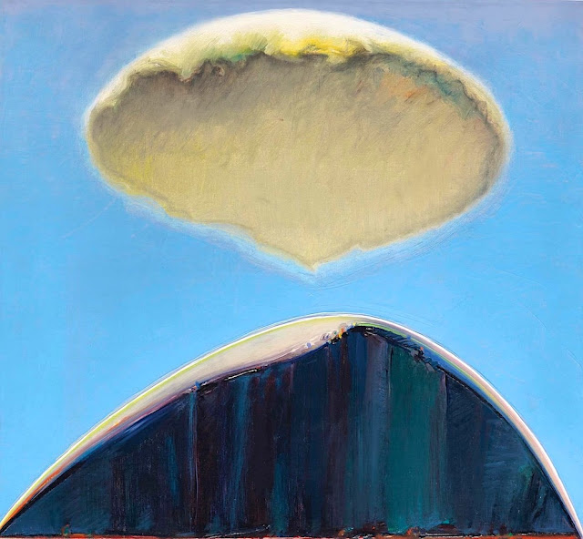
DER NIESEN PAINTED BY MARCUS JACOBI

MARCUS JACOBI (1891-1969), Der Niesen (2, 362m - 7,749 ft), Switzerland  "In The Niesen, Lake Thun, Bernese Oberland, Switzerland," oil on canvas, 105 x 96cm. 1941, Courtesy John Mitchell Fine paintings, London

MARCUS JACOBI (1891-1969)
Der Niesen (2, 362m - 7,749ft
Switzerland

In The Niesen, Lake Thun, Bernese Oberland, Switzerland, oil on canvas, 105 x 96cm, 1941,
Courtesy John Mitchell Fine paintings, London 


The mountain
The Niesen (2, 362m - 7,749ft) is a mountain of the Bernese Alps in Switzerland. It overlooks Lake Thun, in the Bernese Oberland region, and forms the northern end of a ridge that stretches north from the Albristhorn and Mannliflue, separating the Simmental and Kandertal valleys. The literal translation of the German word "Niesen" is "sneeze", but the Niesen because of its shape, is often called The Swiss Pyramid. Administratively, the summit is shared between the municipalities of Reichenbach im Kandertal, to the south-east, and Wimmis, to the west and north. Both municipalities are in the canton of Bern. The summit of the mountain can be reached easily by using the Niesenbahn funicular from Mülenen (near Reichenbach). The construction of the funicular was completed in 1910. Alongside the path of the Niesenbahn is the longest stairway in the world with 11,674 steps. It is open only once a year to the public for a stair run.
The literal translation of the German word Niesen is sneeze. Because of its shape, the Niesen is often called the Swiss Pyramid. Since the 18th century, the Niesen was the subject of a number of paintings which will all be published in this blog, one by one. The Ferdinand Holder's paintings are the two first ones to have been published. The Niesen was also the subject of a number of paintings by Paul Klee, in which it was represented as a quasi-pyramid.

The painter
Born in Biel, Marcus Jacobi came from a family of piano manufacturers and went to study medicine in Bern before becoming a painter. In the 1920s he moved to Merligen on the northern shore of Lake Thun from where this summer panorama was painted. Floating between Ferdinand Hodler and Felix Vallotton, two of the giants of Swiss twentieth century painting, Jacobi’s landscape style fused elements of Realism and Symbolism. He became known for his views of the Niesen, the volcano-like peak which rises to well over 2,000 metres and is one of Switzerland’s most iconic mountains.

__________________________________________
2022 - Wandering Vertexes...
by Francis Rousseau

Thursday, March 3, 2022

RAS MOULAY ALI PAINTED BY JACQUES MAJORELLE

JACQUES MAJORELLE (1886-1962) Ras Moulay Ali, (603 m-1 978 fr) Morocco  In "Tassa, Haut Sexaoua, Grand Atlas, le Ras Moulay Ali", Technique mixte rehaussée d'or et d'argent,1929


JACQUES MAJORELLE (1886-1962)
Ras Moulay Ali, (603 m-1 978 fr)
Morocco

In "Tassa, Haut Sexaoua, Grand Atlas, le Ras Moulay Ali", Technique mixte rehaussée d'or et d'argent,1929


About the painting
In 1926 Majorelle undertook a journey across the Kasbahs of the Atlas. Tassa, easily recognized by its impressive terrace-like layout, was a frequent source of inspiration for Majorelle in the course of 1929. His use of an elaborate technique of tempera with gold and silver highlights adds a strong graphic dimension to the painting. Applying black and ochre highlights, Majorelle subtly hints to the warm lighting of sunset, which accentuates the volume effect, highlighting the terraces and the Great-Atlas in the background. Also, the greenery diffuses an impression of coolness which is in stark contrast with the consuming heat of the dry mineral landscape.“His new compositions exude a distinctive penchant for neatness and simplicity, immense precision and an effort in researching a voluntarily decorative layout.  His fifty compositions were drawn with implacable rigor. The coloring appears in mellow hues and muted shades, which once highlighted with gold and silver, invigorate the entire composition with rich, stirring intemporality” In November 1930, in parallel with an exhibition of seventy drawings and paintings of Kasbahs held at the Renaissance gallery, a book containing thirty views of Kasbahs was also published.
(cf, Félix Marcilhac, La vie et l'œuvre de Jacques Majorelle (1886 - 1962), ed.ACR, 1995, p.137-138)

The painter
Jacques Majorelle son of the celebrated Art Nouveau furniture designer Louis Majorelle, was a French painter. He studied at the École des Beaux-Arts in Nancy in 1901 and later at the Académie Julian in Paris with Schommer and Royer. Majorelle became a noted Orientalist painter, but is most remembered for constructing the villa and gardens that now carry his name, Les Jardins Majorelle in Marrakech.
In around 1917 he travelled to Morocco to recover from heart problems and after short period spent in Casablanca, he visited Marrakech, where he fell in love with the vibrant colours and quality of light he found there. Initially, he used Marrakech as a base for trips to Spain, Italy and other parts of North Africa, including Egypt. Eventually, however, he settled in Marrakech permanently.
He drew inspiration for his paintings from his trips and from Marrakesch itself. His paintings include many street scenes, souks and kasbahs as well as portraits of local inhabitants. He opened a handicrafts workshop in Marrakech and also designed posters to promote travel to Morocco. His work was profoundly affected by his voyages around the Mediterannean and North Africa. He introduced a more coloured vision, bathed in light where the drawing disappears and the image emerges from large spots of colour laid flat. It seemed as if he had discoved the sun in these countries. His style exhibited more freedom and spontaneity.
In 1919, he married Andrée Longueville and the pair lived in an apartment near the Jemâa el-Fna Square (then at the palace of Pasha Ben Daoud). In 1923, Jacques Majorelle bought a four acre plot, situated on the border of a palm grove in Marrakech and in 1931, he commissioned the architect, Paul Sinoir, to design a Cubist villa for him. He gradually purchased additional land, extending his holding by almost 10 acres. In the grounds around the residence, Majorelle began planting a luxuriant garden which would become known as the Jardins Majorelle or Majorelle Garden. He continued to work on the garden for almost forty years. The garden is often said to be the his finest work. Majorelle developed a special shade of the colour blue, which was inspired by the blue tiles prevalent in southern Morocco. This colour was used extensively in Majorelle's house and garden, and now carries his name; Majorelle Blue.
The garden proved costly to run and in 1947, Majorelle opened the garden to the public with an admission fee designed to defray the cost of maintenance. He sold the house and land in the 1950s, after which it fell into disrepair.
Majorelle was sent to France for medical treatment in 1962 following a car accident, and died in Paris, later that year of complications from his injuries. He is buried in Nancy, the place of his birth.
During his lifetime, many of Majorelle's paintings were sold to private buyers and remain in private collections. Some of his early works can be found in Museums around his birthplace such as the Musée de l'Ecole de Nancy. Examples of his later work can be seen in the Mamounia Hotel, Marrakesch, the French Consulate of Marrakech and in the Villa at the Majorelle Gardens.

__________________________________________
2022 - Wandering Vertexes...
by Francis Rousseau


Monday, February 28, 2022

SWARTBERG MOUNTAINS SKETCHED BY DOUGLAS TREASURE


DOUGLAS TREASURE (1917-1995) The Swartberg mountains (2,325 m - 7,628 ft) South Africa (Western Cape)   In Huis Rivier Near Calitzdorp, Cape, watercolour


DOUGLAS TREASURE (1917-1995)
The Swartberg mountains (2,325 m - 7,628 ft)
South Africa (Western Cape)

 In Huis Rivier Near Calitzdorp, Cape, watercolour 


The mountains
The Swartberg mountains (2,325 m - 7,628 ft) (black mountain in Afrikaans) are a mountain range in the Western Cape province of South Africa. It is composed of two main mountain chains running roughly east–west along the northern edge of the semi-arid Little Karoo. To the north of the range lies the other large semi-arid area in South Africa, the Great Karoo. Most of the Swartberg Mountains are above 2000 m high, making them the tallest mountains in the Western Cape. It is also one of the longest, spanning some 230 km from south of Laingsburg in the west to between Willowmore and Uniondale in the east. Geologically, these mountains are part of the Cape Fold Belt. Much of the Swartberg is part of a UNESCO World Heritage Site.

The painter
Douglas Treasure obtained his formal training at the Port Elisabeth School of Art. A commercial art career included extensive experience as a illustrator, designer, visualiser and finally art director of a major company. During this time his love of watercolour landscape painting flourished, and in 1973 he retired from advertising in order to become a full-time professional painter. Douglas Treasure is the only South African represented in best selling British Author Ron Ransom's new book, Watercolour Impressionists. His works are represented in private collections in England, America, Italy, Switzerland, Germany, Australia and Argentina.

_______________________________

2022 - Wandering Vertexes...
by Francis Rousseau
Friday, February 25, 2022

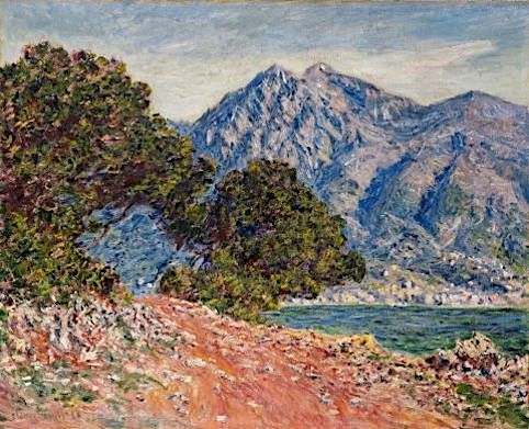
MOUNT SNOWDON PAINTED BY ALFRED DE BREANSKI Sr

ALFRED DE BREANSKI Sr. (1852-1928) Mount Snowdon (1, 085 m -3,560 ft) United Kingdom (Wales)  In Mount Snowdon at midnight,  oil on canvas, 50x72cm- Private collection

ALFRED DE BREANSKI Sr. (1852-1928)
Mount Snowdon (1, 085 m -3,560 ft)
United Kingdom (Wales)

In Mount Snowdon at midnight,  oil on canvas, 50x72cm- Private collection


The mountain
Mount Snowdon (1, 085 m -3,560 ft),Yr Wyddfa in welsh, is the highest mountain in Wales and the highest point in the British Isles south of the Scottish Highlands. A 1682 survey estimated that the summit of Snowdon was at a height of 1,130 m - 3,720 feet ; in 1773, Thomas Pennant quoted a later estimate of 1,088 m- 3,568 ft above sea level at Caernarfon. Recent surveys give the height of the summit as 1,085 m -3,560 ft. The name Snowdon is from the Old English for "snow hill", while the Welsh name – Yr Wyddfa – means "the tumulus" or "the barrow", which may refer to the cairn thrown over the legendary giant Rhitta Gawr after his defeat by King Arthur. As well as other figures from Arthurian legend, the mountain is linked to a legendary Afanc (water monster) and the Tylwyth Teg (fairies). Mount Snowdon is located in Snowdonia National Park (Parc Cenedlaethol Eryri) in Gwynedd. It has been described as "probably the busiest mountain in Britain", with approximately 444,000 people having walked up the mountain in 2016. It is designated as a national nature reserve for its rare flora and fauna. The rocks that form Snowdon were produced by volcanoes in the Ordovician period, and the massif has been extensively sculpted by glaciation, forming the pyramidal peak of Snowdon and the Arêtes of Crib Goch and Y Lliwedd. The cliff faces on Snowdon, including Clogwyn Du'r Arddu, are significant for rock climbing, and the mountain was used by Edmund Hillary in training for the 1953 ascent of Mount Everest.
The summit can be reached by a number of well-known paths, and by the Snowdon Mountain Railway, a rack and pinion railway opened in 1896 which carries passengers the 4.7 miles (7.6 km) from Llanberis to the summit station.

The painter
Alfred de Breanski Sr. is a British landscape painter best known for his idyllic but realistic depictions of rural Scotland and Wales. Thanks to the particular attention paid to the multiple textures, light and colouristic qualities of each landscape, it is evident that Breanski is deeply influenced by the work of John Constable. It is also inspired by the dramatic nature of the Scottish countryside such as the Highlands, noted for their stark beauty and spectacular scenery. Born in 1852 in Greenwich, England, he exhibited his works at the Royal Academy in London from 1872 to 1918. Today, his works are in the collections of the Southampton City Art Gallery, the Laing Art Gallery in Newcastle and museums Brighton & Hove in East Sussex. De Breanski died in London in 1928.

_______________________________

2022 - Wandering Vertexes...
by Francis Rousseau

Monday, February 21, 2022

THE TORRENTHORN IN VINTAGE POSTCARDS 1890


VINTAGE POSTCARDS The Torrenthorn (2,997 m - 9,832 ft) Switzerland (Valais)  In La Suisse en couleurs : Le village de Leukerbad et le Torrenthorn, Valais,  Carte postale 1890


VINTAGE POSTCARDS
The Torrenthorn (2,997 m - 9,832 ft)
Switzerland (Valais)


In  "La Suisse en couleurs : Le village de Leukerbad et le Torrenthorn, Valais", Carte postale 1890


The mountain
The Torrenthorn (2,997 m - 9,832 ft) is a summit of t he Bernese Alps, in Switzerland, located in the canton of Valais,  It is located southwest of the Majinghorn. Its western slope is part of the Loèche-les-Bains ski area, of which it overlooks the village, located to the west. The Bernese Alps are a mountain range of the Alps, located in western Switzerland.  Although the name suggests that they are located in the Berner Oberland region of the canton of Bern, portions of the Bernese Alps are in the adjacent cantons of Valais, Fribourg and Vaud, the latter being usually named Fribourg Alpsand Vaud Alps respectively. The highest mountain in the range, the Finsteraarhorn, is also the highest point in the canton of Bern. The Rhône valley separates them from the Chablais Alps in the west and from the Pennine Alps in the south; the upper Rhône valley separates them from the Lepontine Alps to the southeast; the Grimsel Pass and the Aare valley separates them from the Uri Alps in the east, and from the Emmental Alps in the north; their northwestern edge is not well defined, describing a line roughly from Lake Geneva to Lake Thun. The Bernese Alps are drained by the river Aare and its tributary the Saane in the north, the Rhône in the south, and the Reuss in the east.


Vintage postcards
Postcards were colorized as soon as they appeared on the market  at the end of 19th century ; the photos were then repainted by hand by women with very fine brushes, then a varnish was applied to fix these colors which were always very contrasting... and sometimes very far from reality!
Postcards became popular at the turn of the 20th century, especially for sending short messages to friends and relatives. They were collected right from the start, and are still sought after today by collectors of pop culture, photography, advertising, wartime memorabilia, local history, and many other categories. Postcards were an international craze, published all over the world. The Detroit Publishing Co. and Teich & Co. were two of the major publishers in the U.S, and sometimes individuals printed their own postcards as well. Yvon were the most famous in France. Many individual or anonymous publishers did exist around the world and especially in Africa and Asia (Japan, Thailand, Nepal, China, Java) between 1920 and 1955. These photographer were mostly local notables, soldiers, official guides belonging to the colonial armies (british french, belgium...) who sometimes had rather sophisticated equipment and readily produced colored photograms or explorers, navigators, climbers (Vittorio Sella and the Archiduke of Abruzzi future king of Italy remains the most famous of them).
There are many types of collectible vintage postcards.
Hold-to-light postcards were made with tissue paper surrounded by two pieces of regular paper, so light would shine through. Fold-out postcards, popular in the 1950s, had multiple postcards attached in a long strip. Real photograph postcards (RPPCs) are photographs with a postcard backing.
Novelty postcards were made using wood, aluminum, copper, and cork. Silk postcards–often embroidered over a printed image–were wrapped around cardboard and sent in see-through glassine paper envelopes; they were especially popular during World War I.
In the 1930s and 1940s, postcards were printed on brightly colored paper designed to look like linen.
Most vintage postcard collectors focus on themes, like Christmas, Halloween, portraits of movie stars, European royalty and U.S. presidents, wartime imagery, and photos of natural disasters or natural wonders. Not to mention cards featuring colorful pictures by famous artists like Alphonse Mucha, Harrison Fisher, Ellen Clapsaddle, and Frances Brundage.

__________________________________________ 


2022 - Wandering Vertexes...
by Francis Rousseau


Friday, February 18, 2022

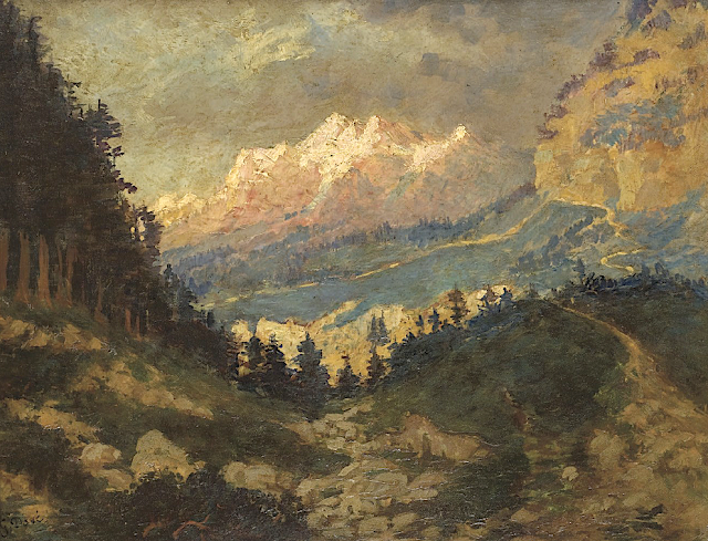
MT SAN CRISTOBAL AND MT BANAHAW PAINTED BY FERNANDO AMORSOLO


FERNANDO AMORSOLO (1892-1972) Mount San Cristobal (1,470 m - 4,820 ft) Mount Banahaw (2, 170m - 7, 120 ft)  Philippines (Luzon)   In Harvesting rice - Mt San Cristobal in the background, Oil on canvas,  The Fernando Amorsolo foundation


FERNANDO AMORSOLO (1892-1972)
Mount San Cristobal (1,470 m - 4,820 ft)
Mount Banahaw (2, 170m - 7, 120 ft)
 Philippines (Luzon)

 In Harvesting rice - Mt San Cristobal in the background, Oil on canvas, 
The Fernando Amorsolo foundation 


The mountains
Mount San Cristobal (1,470 m - 4,820 ft) is a dormant volcano in Quezon province on the island of Luzon, Philippines. The mountain is one of the volcanic features of Macolod Corridor.Mount San Cristobal is considered the Devil's mountain in Filipino folklore. It is the alter-ego of the Holy Mountain,
Mount Banahaw,(2, 170m- 7, 120 ft)   and is part of Mounts Banahaw–San Cristobal Protected Landscape covering 10,901 hectares (26,940 acres) of land.
The mountain is bounded by San Pablo, province of Laguna at its northern slope and Dolores, province of Quezon at its southern slope.

The painter

Fernando Cueto Amorsolo was one of the most important artists in the history of painting in the Philippines.Amorsolo was a portraitist and painter of rural Philippine landscapes. He is popularly known for his craftsmanship and mastery in the use of light. After graduating from the Univeajor influences on his work. Amorsolo set up his own studio upon his return to Manila and painted prodigiously during the 1920s and the 1930s. His Rice Planting (1922), which appeared on posters and tourist brochures, became one of the most popular images of the Commonwealth of the Philippines. Beginning in the 1930s, Amorsolo's work was exhibited widely both in the Philippines and abroad. His bright,optimistic, pastoral images set the tone for Philippine painting before World War II . Except for his darker World War II-era paintings, Amorsolo painted quiet and peaceful scenes throughout his career.
Amorsolo was sought after by influential Filipinos including Luis Araneta, Antonio Araneta and Jorge B. Vargas. Amorsolo also became the favourite Philippine artist of United States officials and visitors to the country. Due to his popularity, Amorsolo had to resort to photographing his works and pasted and mounted them in an album. Prospective patrons could then choose from this catalog of his works. Amorsolo did not create exact replicas of his trademark themes; he recreated the paintings by varying some elements.
His works later appeared on the cover and pages of children textbooks, in novels, in commercial designs, in cartoons and illustrations for the Philippine publications such The Independent, Philippine Magazine, Telembang, El Renacimiento Filipino, and Excelsior. He was the director of the University of the Philippine's College of Fine Arts from 1938 to 1952.
During the 1950s until his death in 1972, Amorsolo averaged to finishing 10 paintings a month. However, during his later years, diabetes, cataracts, arthritis, headaches, dizziness and the death of two sons affected the execution of his works. Amorsolo underwent a cataract operation when he was 70 years old, a surgery that did not impede him from drawing and painting.
After being confined at the St. Luke's Hospital in Quezon City for two months, Amorsolo died at the age of 79 on April 24, 1972. The volume of paintings, sketches and studies of Amorsolo is believed to have reached more than 10,000 pieces. Amorsolo was an important influence on contemporary Filipino art and artists, even beyond the so-called "Amorsolo school." Amorsolo's influence can be seen in many landscape paintings by Filipino artists, including early landscape paintings by abstract painter Federico Aguilar Alcuaz.
In 2003, Amorsolo's children founded the Fernando C. Amorsolo Art Foundation, which is dedicated to preserving Fernando Amorsolo's legacy, promoting his style and vision, and preserving a national heritage through the conservation and promotion of his works.


__________________________________________
2022 - Wandering Vertexes...
by Francis Rousseau

Monday, February 14, 2022

THE PUY GRIOU PAINTED BY CHARLES JAFFEUX

CHARLES JAFFEUX  (1902-1941) Puy Griou  (1,690m  - 4,921ft) France (Cantal)   In  Vue d'un buron près du Puy Griou dans les Monts d'Auvergne, Mandailles, oil on canvas,  40 x 50cm, Private collection

CHARLES JAFFEUX  (1902-1941)
Puy Griou  (1,690 m  - 5,544 ft)
France (Cantal) 

In  Vue d'un buron près du Puy Griou dans les Monts d'Auvergne, Mandailles, oil on canvas,  40 x 50cm, Private collection


The mountain
The Puy Griou (1,690-meter) is peak in the Cantal mountains located on the ridge line between the Cère and Jordanne valleys, halfway in the municipalities of Saint-Jacques-des-Blats and Mandailles.
The summit is called Puei Griu in Aurillac Occitan which means “painful to climb”.
Due to its position in the center of the Cantal mountains and its very slender conical shape, the Puy Griou has long been presented as the eroded chimney of the Cantal volcano. But it has since lost this rank and geologists now consider it to be a phonolite dome occupying a central position but of similar origin to other peaks in the massif such as the Hozières rock. It would have been in place about 6 million years ago, after the paroxysmal eruptive phases experienced by Cantal between 8.5 Ma and 6.5 Ma4. During the cold periods of the recent Quaternary, the repeated action of freezing and thawing cut the rock into slates to form a scree sleeve.
The GR 400 follows the ridge line between the Col du Pertus and the Col de Rombière, near the Lioran ski resort. At the foot of the dome, a path deviates towards the south, allowing the ascent of the last 200 meters of drop.

The painter
Charles Jaffeux, is a French painter and engraver from the Auvergne region. His father François Jaffeux, watchmaker and jeweler in Riom, was a watercolorist and passionate about painting. A pupil of the Ecole des Beaux-Arts in Clermont-Ferrand, then the Ecole des Beaux-Arts in Paris, where he was a pupil of Charles Albert Waltner (1846-1925), he also attended the Académie de la Grande Chaumière. He is attached to the artists of the Murol school. Back in Auvergne, he launched into the production of etchings of the monuments of the region which he had published as postcards, which ensured him a comfortable income allowing him to devote himself to painting landscapes of the region. Auvergne. He also draws and paints cities and characters from other regions, in particular from Brittany, the landscapes of the Alps, Provence. His engraved work includes more than 436 pieces representing views, animated or not, of Auvergne, and the south of the Massif-Central, the Alps, Brittany, the Center-West, Normandy, the south of France as well as only views of Bourges, Lyon, Paris, Pérouges. It excels in rendering old buildings and old walls. Charles Jaffeux exhibited twice at the Salon of the National Society of Fine Arts, in 1935 and 1936, where he presented copper engravings.

__________________________________________
2022 - Wandering Vertexes...
by Francis Rousseau  
Friday, February 11, 2022

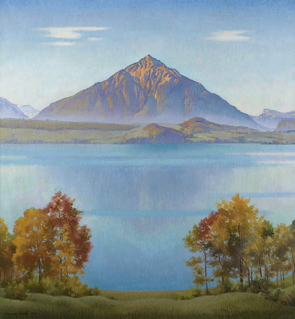
THE MOUNT PELÉ BY PAUL LEMAGNY FOR IN VINTAGE STAMPS 1955


VINTAGE STAMP 1955 Mount Pelée (1,397 m - 4,583 ft) France ( Martinique)

VINTAGE STAMP 1955

PAUL LEMAGNY (1905-1977)
Mount Pelée (1,397 m - 4,583 ft)
France (Martinique) 


The artist
Paul Pierre Lemagny (1905-1977) is a French painter and engraver. Between 1940 and 1958, Paul Lemagny designed more than two hundred models of stamps for the postal administration, in particular the portrait of many illustrious men, one of his specialties. Forty-five of these models gave rise to the issue of a stamp, including Madame Récamier, who received the philatelic art prize awarded for the first time at the CNEP's autumn show in 1950. He also created a series on symbolist poets (Baudelaire, Verlaine and Rimbaud) who are models of the genre both in the portraits of the poets and in the evocations of their works. Lemagny was elected to the French Academy of Fine Arts in 1949, of which he became the youngest member at age 43.


The Volcano
Mount Pelé (1,397 m - 4,583 ft ) or Mount PElée  (Le Mont Pelé (in french), is an active volcano at the northern end of Martinique, an island and French overseas department in the Lesser Antilles Volcanic Arc of the Caribbean. Its volcanic cone is composed of stratified layers of hardened ash and solidified lava. Its most recent eruption was in 1932.  The stratovolcano's 1902 eruption destroyed the town of Saint-Pierre, killing 29,000 to 30,000 people in the space of a few minutes, in the worst volcanic disaster of the 20th century. ] The main eruption, on 8 May 1902, left only two survivors in the direct path of the blast flow: Ludger Sylbaris survived because he was in a poorly ventilated, dungeon-like jail cell and Léon Compère-Léandre, living on the edge of the city, escaped with severe burns. The volcano is currently active.  On December 6, 2020, The Martinique Volcano Observatory (MVO) has raised Mount Pelee's alert level to Yellow [Restless] from Green [Normal] due to an increase in seismicity under the volcano beginning in April 2019, and observations of tremor last month. As far as is known, this is the first sign of activity since the end of the 1929-32 eruption. This volcano is, of course, highly dangerous, and great vigilance of its activity is required. Whether or not it is going to enter a new eruptive period is currently unknown. According to the MVO press release "The increase in seismicity of superficial volcanic origin (up to 4-5 km below the summit) observed since April 2019, is therefore clearly above the base level characteristic for Mount Pelée.  In April 2019, volcanic seismicity appeared at depth around and under Mount Pelée (more than 10 km below sea level). It could correspond to the arrival at depth of magmatic fluids. Finally, new recorded tremor-type signals were observed on November 8 and 9, 2020: they could correspond to a reactivation of the hydrothermal system. Even if, in the current state of measurements, there is no deformation of the volcano on the scale of the observation network, the appearance, in a few months, of these three different types of seismic signals of volcanic origin shows a clear change in the behavior of the volcanic system, the activity of which is increasing from the base level observed over several decades."

___________________________________________
2022 - Wandering Vertexes...
by Francis Rousseau 

Tuesday, February 8, 2022

AEOLIS MONS OR MOUNT SHARP BY NASA CURIOSITY MISSION


NASA CURIOSITY MISSION (since 2012) Aeolis Mons or Mount Sharp (5, 500 m - 18, 000 ft) Mars  In at the base of Aeolis Mons on Mars (23 August 2012)

NASA CURIOSITY MISSION (since 2012)
Aeolis Mons or Mount Sharp (5, 500 m - 18, 000 ft)
Mars

From "At the base of Aeolis Mons on Mars ", photo, 23 August 2012


The mountain
Aeolis Mons (5, 500 m - 18, 000 ft) also called Mount Sharp is a mountain on the surface of the planet Mars. It forms the central peak within Gale crater and is located around 5.08°S 137.85°E, rising 5.5 km (18,000 ft) high from the valley floor. Aeolis Mons is about the same height as Mons Huygens, the tallest lunar mountain, and taller than Mons Hadley visited by Apollo 15. The tallest mountain known in the Solar System is in Rheasilvia crater on the asteroid Vesta, which contains a central mound that rises 22 km or 22.000 m - 14 mi or 72,000 ft high.
Olympus Mons on Mars is nearly the same height, at 21.9 km (13.6 mi; 72,000 ft) high.
In comparison, Mount Everest / Chomolunga rises to 8.8 km -29,000 ft altitude above sea level, but is only 4.6 km - 15,000 ft base-to-peak. Africa's Mount Kilimanjaro is about 5.9 km - 19,000 ft altitude above sea level also 4.6 km base-to-peak. America's Denali, also known as Mount McKinley, has a base-to-peak of 5.5 km -18,000 ft. The Franco-Italian Mont Blanc/Monte Bianco is 4.8 km -16,000 ft in altitude above sea level. Mount Fuji, which overlooks Tokyo, Japan, is about 3.8 km -12,000 ft altitude. Compared to the Andes, Aeolis Mons would rank outside the hundred tallest peaks, being roughly the same height as Argentina's Cerro Pajonal; the peak is higher than any above sea level in Oceania, but base-to peak it is considerably shorter than Hawaii's Mauna Kea and its neighbors.
Discovered in the 1970s by NAS, the mountain remained nameless for perhaps 40 years. When it became a likely landing site, it was given various labels; for example, in 2010 a NASA photo caption called it "Gale crater mound". In March 2012, NASA unofficially named it "Mount Sharp", for American geologist Robert P. Sharp. The International Astronomical Union, which is responsible for planetary nomenclature for its participants, names large Martian mountains after the Classical albedo feature in which it is located, not for people. In May 2012 the IAU thus named the mountain Aeolis Mons, and gave the name Aeolis Palus to the crater floor plain between the northern wall of Gale and the northern foothills of the mountain. Despite the official name, NASA and the ESA continue to refer to the mountain as "Mount Sharp" in press conferences and press releases
Aeolis is the ancient name of the Izmir region in western Turkey.

The NASA mission
On August 6, 2012, Curiosity (the Mars Science Laboratory rover) landed in "Yellowknife" Quad of Aeolis Palus, next to the mountain. NASA named the landing site Bradbury Landing on August 22, 2012. Aeolis Mons is a primary goal for scientific study.
On June 5, 2013, NASA announced that Curiosity would begin a 8 km (5.0 mi) journey from the Glenelg area to the base of Aeolis Mons.
On November 13, 2013, NASA announced that an entryway Curiosity would traverse on its way to Aeolis Mons was to be named "Murray Buttes", in honor of planetary scientist Bruce C. Murray (1931–2013). The trip was expected to take about a year and would include stops along the way to study the local terrain.
On September 11, 2014, NASA announced that the Curiosity rover had reached Aeolis Mons, the rover mission's long-term prime destination.
On October 5, 2015, possible recurrent slope lineae, wet brine flows, were reported on Mount Sharp near Curiosity.
As of January 20, 2017, Curiosity has been on the planet Mars for 1585 sols (1628 days) since landing on August 6, 2012. 

___________________________________________
2022 - Wandering Vertexes...
by Francis Rousseau


Saturday, February 5, 2022

LOS FRAILES OR THE ORGANS OF ACTOPAN BY ALEXANDER VON HUMBOLDT


ALEXANDER VON HUMBOLDT (1769-1859) WILHELM FRIEDRICH ( 1760-1820), engraver The Organs of Actopan or Los Frailes (1,140 m - 3,740 ft) Mexico (Hidalgo) In Vues des Cordillères, et monumens des peuples indigènes de l'Amérique from the book  Voyage aux régions équinoxiales du nouveau continent, 1813

ALEXANDER VON HUMBOLDT (1769-1859)
WILHELM FRIEDRICH ( 1760-1820), engraver
The Organs of Actopan or Los Frailes (1,140 m - 3,740 ft)
Mexico (Hidalgo)

In Vues des Cordillères, et monumens des peuples indigènes de l'Amérique from the book  Voyage aux régions équinoxiales du nouveau continent, 1813


About this engraving and the mountain

On May 23 and 24, Humboldt would tour the Actopan Valley, and then leave on May 25 for Mexico City. During the visit, Humboldt drew and studied the Organs of Actopan, also known as Los Frailes,located 17 km southeast of Actopan in the municipality of El Arenal. Humboldt determines their height trigonometrically.In Actopan. The slender part of the rock is a hundred meters high; but the absolute elevation of the summit of the mountain, where the Organos begin to stand out, is 585 toises (1,140 m - 3,740 ft) .  It is on the way from Mexico to the mines of Guanaxuatotjuon distinguishes from very far away, and standing out on Thoiizon, the rock of Mamanchota: it rises in the middle of a forest of oaks, and oflers a very picturesque aspect. 

The artist and explorer
Friedrich Wilhelm Heinrich Alexander von Humboldt was a Prussian geographer, naturalist, explorer, and influential proponent of Romantic philosophy and science. He was the younger brother of the Prussian minister, philosopher, and linguist Wilhelm von Humboldt (1767–1835). Humboldt's quantitative work on botanical geography laid the foundation for the field of biogeography. Humboldt's advocacy of long-term systematic geophysical measurement laid the foundation for modern geomagnetic and meteorological monitoring.
Between 1799 and 1804, Humboldt travelled extensively in Latin America, exploring and describing it for the first time from a modern scientific point of view. His description of the journey was written up and published in an enormous set of volumes over 21 years. Humboldt was one of the first people to propose that the lands bordering the Atlantic Ocean were once joined (South America and Africa in particular). Humboldt resurrected the use of the word cosmos from the ancient Greek and assigned it to his multi-volume treatise, Kosmos, in which he sought to unify diverse branches of scientific knowledge and culture. This important work also motivated a holistic perception of the universe as one interacting entity.
On their way back to Europe from Mexico on their way to the United States, Humboldt and his fellow scientist Aimé Bonpland stopped in Cuba for a while. After their first stay in Cuba of three months they returned the mainland at Cartagena de Indias (now in Colombia), a major center of trade in northern South America. Ascending the swollen stream of the Magdalena River to Honda and arrived in Bogotá on July 6, 1801 where they met Spanish botanist José Celestino Mutis, the head of the Royal Botanical Expedition to New Granada, staying there until September 8, 1801. Mutis was generous with his time and gave Humboldt access to the huge pictorial record he had compiled since 1783. Humboldt had hopes of connecting with the French sailing expedition of Baudin, now finally underway, so Bonpland and Humboldt hurried to Ecuador. They crossed the frozen ridges of the Cordillera Real, they reached Quito on 6 January 1802, after a tedious and difficult journey.
Their stay in Ecuador was marked by the ascent of Pichincha and their climb of Chimborazo, where Humboldt and his party reached an altitude of 19,286 feet (5,878 m). This was a world record at the time, but a thousand feet short of the summit. Humboldt's journey concluded with an expedition to the sources of the Amazon en route for Lima, Peru.
At Callao, the main port for Peru, Humboldt observed the transit of Mercury. On 9 November and studied the fertilizing properties of guano, rich in nitrogen, the subsequent introduction of which into Europe was due mainly to his writings.
___________________________________________
2022 - Wandering Vertexes...
by Francis Rousseau


Tuesday, February 1, 2022

THE GRINDELWALD GLACIER PAINTED BY THOMAS FEARNLEY

THOMAS FEARNLEY  (1802-1842) The Grindelwald Glacier  (1, 349 m - 4, 425m) Switzerland   In The Grindelwald Glacier, oil on canvas  1838, 194 x 157 cm, Nasjonalmuseet, Oslo

 
THOMAS FEARNLEY  (1802-1842)
The Grindelwald Glacier  (1, 349 m - 4, 425m)
Switzerland (Bernese Alps)

 In The Grindelwald Glacier, oil on canvas  1838, 194 x 157 cm, Nasjonalmuseet, Oslo


About the painting
In The Grindelwaldgletscher, the highlight of Thomas Fearnley’s Swiss landscape paintings, the viewer gazes up from the grassy knoll in the foreground toward the bottom of a valley filled by a glacier. The majestic composition is based on Fearnley’s on-site observations. A sketch in pencil from August 1835 reveals a barren landscape in front of the glacier. The large trees, which form such an essential part of the picture’s overall composition, stem from studies of trees Fearnley made a week later in Scheideck. Fearnley has made the landscape more overpowering than in the original on-site drawing. The mountainsides are steeper and have been accentuated through light and shadow. The contrast to the everlasting ice and snow of the desolate valley is heightened by the lush vegetation in the foreground, where sheep graze under a shepherd’s supervision. Fearnley emphasizes the wild, inaccessible aspects of nature by letting a bird of prey glide above the glacier, even as he playfully includes a visual, English-based pun on his name by adding a tuft of fern next to his signature.
Scholars have noted how the composition and the balancing of the various landscape elements evoke the Düsseldorf painter Johann Wilhelm Schirmer (1807–63), whom Fearnley met during his sojourn in Switzerland. In romanticism, a pronounced contrast between warm and cold tones, as seen here, was also perceived as symbolizing the confrontation between life and death. Before the painting was completed, it was shown at the Paris Salon in 1836. Along with two paintings by J. C. Dahl, this painting and Fearnley’s The Labro Falls at Kongsberg (1837) were the first paintings by Norwegians artists to be acquired by the National Gallery.

The glacier
The Lower Grindelwald Glacier also known as the Lower Grindelwald Glacier is a glacier in the Bernese Alps, located southeast of Grindelwald, in the canton of Bern (Swiss). It originates under the Agassizhorn and the Strahlegghorn and is connected to the Unteraar glacier via the Finsteraarjoch (3,283 m). The Lower Grindelwald Glacier should not be confused with the Upper Grindelwald Glacier, located to the northeast. The Lower Grindelwald Glacier still has a major tributary, the Ischmeer (“sea of ​​ice” in Swiss German, formerly known as the “Grielwald-Fiescher Glacier”, German: Grindelwald-Fieschergletscher3), which is the glacier overlooked by the Eismeer station of the Jungfrau Railway.
The Lower Grindelwald Glacier was 8.3 km long and covered an area of ​​20.8 km2 in 1973. It has shrunk considerably since, being only 6.2 km long in 2015, the 1.9 km retreat being mainly intervened since 2007. In the middle of the 19th century, the glacier reached the valley of Grindelwald as far as Mettenberg, at an altitude of 983 m, near the confluence of the white Lütschine and the black Lütschine. In 1900 it still extended to the Rotenflue (1,200 m) and filled the whole valley from its present end, the glacial lake, with a thickness of about 300 m up to an altitude of 1,700 m, just below the current hiking trail around the Bänisegg. In the early 2000s, it had retreated to the gorge between the Hörnli (Eiger) ridge and the Mättenberg. 

The painter
Thomas Fearnley attended National Cadet Corps from 1814 to 1819. He was a student of the Norwegian National Academy of Craft and Art Industry (1819–1821), Art Academy in Copenhagen (1821–1823) and the Art Academy (n Stockholm (1823–27) under Carl Johan Fahlcrantz. Fearnley left Copenhagen bound for Stockholm in the autumn of 1823 to complete a painting commissioned by Crown Prince Oscar of Norway and Sweden. He received several orders from the Swedish royal family and from other members of the royal court including Swedish Count Gustaf Trolle-Bonde. He conducted study tours in Norway (1824-1826), at which time he met Johan Christian Dahl in Sogn. After another stay in Copenhagen from 1827 to 1828 and a new Norwegian trip in the autumn of 1828, he went to Germany and was a student of Dahl in Dresden (1829–1830) as well as befriending the German painter Joseph Petzl and the German-Danish painter Friedrich Bernhard Westphal. He lived in Munich (1830–32). Fearnley traveled extensively in the 1830s, visiting Munich, Paris, London, Hull and the English Lake district. During September 1832, he went from Venice to Rome and visited Sicily the following summer. He mostly painted in small towns south of Naples: Castellammare, Amalfi, Sorrento, Capri and in Switzerland: Meiringen, Grindelwald. He went to Paris in the summer of 1835 and visited London the next year. During the summer of 1839 he was on a study tour to the Sognefjord and Hardangerfjord, together with the German painter Andreas Achenbach. Fearnley's paintings alternate between oil sketches and larger, composed landscapes meant for exhibition. His large studio compositions have a cool monumental attitude with a taste for the powerful and wildly romantic in the favorite motifs, wilderness and waterfalls, and with a strong emphasis on the image's architectural structure. The National Gallery in Oslo owns a total of 54 of his smaller pictures and sketches and also a series of drawings. Notable works in this collection include Labrofossen (1837), Grindelwaldgletsjeren (1838) and Slinde Birken (1839). Other notable collections are located in the Bergen Kunstmuseum and the Nationalmuseum in Stockholm.

___________________________________________

2022 - Wandering Vertexes...
by Francis Rousseau