google.com, pub-0288379932320714, DIRECT, f08c47fec0942fa0 GRAVIR LES MONTAGNES... EN PEINTURE

Wednesday, March 22, 2017

MOUNT ERRIGAL PAINTED BY PAUL HENRY


PAUL HENRY (1877-1958)
 Mount Errigal  (751m - 2, 464 ft)
Ireland 

The mountain
Mount Errigal  (751m - 2, 464 ft) called in Irish An Earagail, possibly meaning "oratory" is a mountain near Gweedore in County Donegal, Ireland. It is the tallest peak of the Derryveagh Mountains, the tallest peak in County Donegal, and the 76th tallest peak in Ireland.  Errigal is also the most southern, steepest and highest of the mountain chain, called the "Seven Sisters" by locals. The Seven Sisters includes Muckish, Crocknalaragagh, Aghla Beg, Ardloughnabrackbaddy, Aghla More, Mackoght and Errigal. The nearest peak is Mackoght, which is also known as Little Errigal or Wee Errigal (Irish: an Earagail Bheag). Errigal is well known for the pinkish glow of its quartzite in the setting sun. Another noted quality is the ever-changing shape of the mountain depending on what direction you view it from. Errigal was voted 'Ireland's Most Iconic Mountain' by Walking & Hiking Ireland in 2009.
Climbing
The mountain is most often climbed from the carpark off the R251 road. The route initially starts off by crossing heavily eroded and boggy land towards a visible track through the shiny scree from where the ascent proper starts. After reaching the summit, people usually walk the short but exposed walk along ‘One Man’s Pass’ which leads across to the second and lower of the twin summits. No special equipment is needed to climb the mountain, but caution is advised.

The painter
Paul Henry was an Irish artist noted for depicting the West of Ireland landscape and particularly landscapes of Achill Island and Connemara in a spare post-impressionist style. Born in Belfast, Ireland, the son of a Baptist minister, Paul Henry began studying at Methodist College Belfast in 1882. During this period he first began drawing regularly. At the age of fifteen he moved to the Royal Belfast Academical Institution. He studied art in Belfast before going to Paris in 1898 to study at the Académie Julian and at Whistler's studio. He married the painter Grace Henry in 1903 and returned to Ireland in 1910. From then until 1919 he lived on , where he learned to capture the peculiar interplay of light and landscape specific to the West of Ireland. In 1919 he moved to Dublin and in 1920 was one of the founders of the Society of Dublin Painters.  In the 1920s and 1930s Paul Henry was Ireland's best known artist, one who had a considerable influence on the popular image of the west of Ireland. Although he seems to have ceased experimenting with his technique after he left Achill and his range is limited, he created a large body of fine images whose familiarity is a testament to its influence. The National Gallery of Ireland held a major exhibition of his work in 2004.
A painting by Paul Henry was featured on an episode of the BBC's Antiques Roadshow, broadcast on 12 November 2006. The painting was given a value of approximately £40,000 - £60,000 by the roadshow. However, due to the buoyancy of the Irish art market at that time, it sold for €260,000 on 5 December 2006 in James Adams' and Bonhams' joint Important Irish Art sale.
Source: 
- Paul Henry and Achill Island

Tuesday, March 21, 2017

SUPERSTITION MOUNTAIN PAINTED BY HANSON PUTHUFF


HANSON PUTHUFF (1875-1972)
Superstition mountain (1,910 m - 6,266 ft) 
United State of America (Arizona) 


In Enduring Ramparts - Superstition Mountains 

The mountain
 Superstition Mountain (1,910 m - 6,266 ft) is part of the Supertistions mountains range popularly called "The Superstitions",  also called Wi:kchsawa in Yavapai langage and Sierra de la Espuma  Spanish. It is  located in Arizona, east of Phoenix. The mountain range is in the federally designated Superstition Wilderness Area, and includes a variety of natural features in addition to its namesake mountain. 
- Weavers Needle, a prominent landmark and rock climbing destination set behind and to the east of Superstition Mountain, is a tall eroded volcanic remnant that plays a significant role in the legend of the Lost Dutchman's Gold Mine. According to this legend, a German immigrant named Jacob Waltz discovered a mother lode of gold in the Superstition Wilderness and revealed its location on his deathbed in Phoenix in 1891 to Julia Thomas, a boarding-house owner who had taken care of him for many years. 
-  Peralta Canyon, on the northeast side of Superstition Mountain, contains a popular trail that leads up to Fremont Saddle, which provides a very picturesque view of Weavers Needle. Some Apaches believe that the hole leading down into the lower world, or hell, is located in the Superstition Mountains. Winds blowing from the hole is supposed to be the cause of severe dust storms in the metropolitan region.
- Miner's Needle is another prominent formation in the wilderness and a popular hiking destination.
The Superstition Mountains have a desert climate, with high summer temperatures and a handful of perennial sources of water.  Numerous hiking trails cross the mountains from multiple access points, including the Peralta Trailhead, the most popular. The Lost Dutchman State Park, located on the west side of Superstition Mountain, includes several short walking trails.
The Superstition Mountains are bounded roughly by U.S. Route 60 on the south, State Route 88 on the northwest, and State Route 188 on the northeast.

The painte
Hanson Duvall Puthuff was a landscape painter and muralist, born in Waverly, Missouri. Puthuff studied at the Art Institute of Chicago before moving to Colorado in 1889 to study at University of Denver Art School. He traveled to Los Angeles in 1903 and for 23 years worked as a commercial artist painting billboards while painting landscapes in his leisure. In 1926, he abandoned commercial art and devote full-time to fine art and exhibitions. He is nationally famous for his lyric interpretations of the Southern California deserts.  Puthuff was one of the cofounders of the California Art Club and the Laguna Beach Art Association. He won awards in 1909 from the Alaska–Yukon–Pacific Exposition, a bronze medal at the Paris Salon in 1914, and two silver medals from the Panama-California Exposition in 1915. His works are exhibited in, among other places, the Los Angeles County Museum of Art, Laguna Art Museum, and Bowers Museum. Many of his works are also cataloged in the Smithsonian American Art Museum art inventory. Puthuff died in Corona del Mar on May 12, 1972. In 2007, the Pasadena Museum of California Art featured California Colors: Hanson Puthuff, the first solo museum exhibition of his work. In conjunction with the exhibit, the Museum republished the artist's autobiography.

Monday, March 20, 2017

MULHACEN PAINTED BY JOAQUIN SOROLLA


JOAQUIN SOROLLA Y BATISTA  (1863-1923)
 Mulhacén  (3, 478 m - 11,411ft)
Spain

Painted in 1890

The mountain 
Mulhacén (3, 478 m - 11,411ft) is the highest mountain in continental Spain and in the Iberian Peninsula. It is part of the Sierra Nevada range in the Cordillera Penibética. It is named after Abu l-Hasan Ali, or Muley Hacén as he is known in Spanish, the penultimate Muslim King of Granada in the 15th century who, according to legend, was buried on the summit of the mountain.
Mulhacén is the highest peak in Europe outside the Caucasus Mountains and the Alps. It is also the third most topographically prominent peak in Western Europe, after Mont Blanc and Mount Etna, and is ranked 64th in the world by prominence.  The peak is not exceptionally dramatic in terms of steepness or local relief. The south flank of the mountain is gentle and presents no technical challenge, as is the case for the long west ridge. The shorter, somewhat steeper north east ridge is slightly more technical. The north face of the mountain, however, is much steeper, and offers several routes involving moderately steep climbing on snow and ice (up to French grade AD) in the winter
Mulhacén can be climbed in a single day from the villages of either Capileira or Trevélez, but it is more common to spend a night at the mountain refuge at Poqueira, or in the bare shelter at Caldera to the west. Those making the ascent from Trevelez can also bivouac at the tarns to the northeast of the peak.


The painter 
Joaquin Sorolla y Bastida  was a Spanish painter.  Sorolla excelled in the painting of portraits, landscapes, and monumental works of social and historical themes. His most typical works are characterized by a dexterous representation of the people and landscape under the sunlight of his native land....
More about Joaquin Sorolla, follow the link. 

Sunday, March 19, 2017

TINDFJALLAJÖKULL PAINTED BY ASGRIMUR JONSSON

http://wanderingvertexes.blogspot.com


ASGRIMUR JONSSON (1876-1958)
  Tindfjallajökull (1,462m - 4,797ft) 
Iceland

 Painted in 1909

The mountain 
Tindfjallajцkull (1,462m - 4,797ft) is a stratovolcano in the south of Iceland.  It has erupted rocks of basaltic to rhyolitic composition, and a 5-km-wide caldera was formed during the eruption of the 54,000-year-old Thуrsmцrk Ignimbrite. It is capped by a glacier of 19 km2. Its highest peak is Ymir which takes its name from the giant Ymir of Norse mythology. The most recent eruption was at an unknown time in the Holocene. The name means "Tindfjцll glacier". Tindfjцll ("peak mountains") is a ridge that extends to the south of the glacier. The rivers that flow from the glacier are Hvitmaga to the north-east, Gilsa to the south, Porolfsa to the south-west, Vala to the north-west and Blesa to the north. Hvнtmaga, Gilsб and Юуrуlfsб drain into Markarfljot while Vala and Blesa drain into Eystri Ranga.

 The Painter 
Asgrímur Jónsson was an Icelandic painter, and one of the first in the country to make art a professional living. He studied at the Royal Academy in Copenhagen between 1900 and 1903 and traveled widely after graduation. The subjects of his pictures are mostly the landscapes of his home country, particularly mountains. His painting style is similar to the French impressionists like Corot. Some of his pictures also illustrate Icelandic sagas and folk tales.
He was also noted for his murals in various churches in Iceland. A number of his works are on display in the National Gallery of Iceland. Jónsson influenced many artists in Iceland. A short time before he died he had donated his house in Reykjavík to the Icelandic Government along with all those paintings which were at that time in his possession. These consisted of 192 oil paintings and 277 water colours together with a great number of unfinished pictures dating from various periods in his life. During his lifetime Ásgrímur Jónsson was honoured in many ways. He was made honorary professor at the University of Iceland and, in 1933 he was made Grand Knight of the Icelandic Order of the Falcon. He was an honorary member of the Royal Swedish Academy of Arts and Knight of Dannebrog, first class. He died in 1958 and was buried in Gaulverjabær.


2017 - Wandering Vertexes...
by Francis Rousseau 


Saturday, March 18, 2017

HUNTS MESA BY ARTHUR WESLEY DOW


ARTHUR WESLEY DOW (1857-1922)
Hunts Mesa (1,942 m - 6,370 ft)
United State of America (Arizona)

In The Enchanted Mesa, 1913

The mountain 
Hunts Mesa (1,942 m - 6,370 ft) is a rock formation located in Monument Valley, south of the border between Utah and Arizona in the United States and west of the border between Arizona's Navajo County and Apache County. It is one of two popular interior destinations in the Monument Valley Navajo Tribal Park for tourists to experience panoramic views of the popular sandstone formations from a distance. The other is Mystery Valley. A Navajo guide is required to hike to either.
Hunts Mesa forms the southeastern edge of Monument Valley and the northern edge of Little Capitan Valley. Access to Hunts Mesa is not through the general entrance of the park but rather through the sand dunes northeast of the town of Kayenta, Arizona.
On October 16, 1984, a United States Air Force B-52G bomber crashed on Hunts Mesa, killing two of the seven crewmen.

The painter 
Arthur Wesley Dow was an American painter, printmaker, photographer and influential arts educator.
Dow taught at three major American arts training institutions over the course of his career beginning with the Pratt Institute from 1896-1903 and the New York Art Students League from 1898-1903; then, in 1900, he founded and served as the director of the Ipswich Summer School of Art in Ipswich, Massachusetts, and from 1904 to 1922, he was a professor of fine arts at Columbia University Teachers College. His ideas were quite revolutionary for the period; he taught that rather than copying nature, art should be created by elements of the composition, like line, mass and color.  He wanted leaders of the public to see art is a living force in everyday life for all, not a sort of traditional ornament for the few. Dow suggested this lack of interest would improve if the way art was presented would permit self-expression and include personal experience in creating art. His ideas on Art were published in the 1899 book Composition: A Series of Exercises in Art Structure for the Use of Students and Teachers. The following extracts are from the prefatory chapter "Beginnings" to the second edition of this book (1912) : " Composition ... expresses the idea upon which the method here presented is founded - the "putting together" of lines, masses and colors to make a harmony. ... Composition, building up of harmony, is the fundamental process in all the fine arts. ... A natural method is of exercises in progressive order, first building up very simple harmonies ... Such a method of study includes all kinds of drawing, design and painting. It offers a means of training for the creative artist, the teacher or one who studies art for the sake of culture."

Friday, March 17, 2017

THE STROMBOLI PAINTED BY LUIGI MAYER


LUIGI MAYER (1755-1803) 
Stromboli volcano  (924 m -3,031 ft)
Italy (Island of Stromboli) 

In Island of Stromboli, New York Public Library 

The mountain 
Stromboli  is a small island in the Tyrrhenian Sea, off the north coast of Sicily, containing one of the three active volcanoes  (924 m -3,031 ft) in Italy. It is one of the eight Aeolian Islands, a volcanic arc north of Sicily. This name is derived from the Ancient Greek name Strongulē which was given to it because of its round swelling form. The island's population is about 500. The volcano has erupted many times and is constantly active with minor eruptions, often visible from many points on the island and from the surrounding sea, giving rise to the island's nickname "Lighthouse of the Mediterranean". The most recent major eruption was on 13 April 2009. Stromboli stands 926 m (3,034 ft) above sea level, and over 2,700 m (8,860 ft) on average above the sea floor.  There are three active craters at the peak. A significant geological feature of the volcano is the Sciara del Fuoco ("Stream of fire"), a big horseshoe-shaped depression generated in the last 13,000 years by several collapses on the northwestern side of the cone. Two kilometers to the northeast lies Strombolicchio, the volcanic plug remnant of the original volcano.
Mt. Stromboli has been in almost continuous eruption for the past 2,000 years. A pattern of eruption is maintained in which explosions occur at the summit craters, with mild to moderate eruptions of incandescent volcanic bombs, at intervals ranging from minutes to hours. This Strombolian eruption, as it is known, is also observed at other volcanoes worldwide. Eruptions from the summit craters typically result in a few short, mild, but energetic bursts, ranging up to a few hundred meters in height, containing ash, incandescent lava fragments and stone blocks. Stromboli's activity is almost exclusively explosive, but lava flows do occur at times when volcanic activity is high: an effusive eruption occurred in 2002, the first in 17 years, and again in 2003, 2007, and 2013–14. Volcanic gas emissions from this volcano are measured by a Multi-Component Gas Analyzer System, which detects pre-eruptive degassing of rising magma, improving prediction of volcanic activity.

The artist
Luigi Mayer was an Italian-German artist and one of the earliest and most important late 18th-century European painters of the Ottoman Empire. Mayer was a close friend of Sir Robert Ainslie, 1st Baronet, a British ambassador to Turkey between 1776 and 1792, and the bulk of his paintings and drawings during this period were commissioned by Ainslie.  He travelled extensively through the Ottoman Empire between 1776 and 1794, and became well known for his sketches and paintings of panoramic landscapes of ancient sites from the Balkans to the Greek Islands, Sicily, Turkey and Egypt, particularly ancient monuments and the Nile. Many of the works were amassed in Ainslie's collection, which was later presented to the British Museum, providing a valuable insight into the Middle East of that period.

Thursday, March 16, 2017

SAN JACINTO PEAK PAINTED BY JOHN FROST


JOHN FROST (1890-1937)
 San Jacinto Peak  (3,302 m - 10,834 ft) 
 United States of America (California) 

1. In  Mount San Jacinto, Whitewater Wash, 1926, oil on canvas
2. In Mount San Jacinto, 1928, oil on canvas

The mountain
San Jacinto Peak  (3,302 m - 10,834 ft) often designated Mount San Jacinto, is the highest peak of the San Jacinto Mountains, and of Riverside County, California. It lies within Mount San Jacinto State Park. To the Cahuilla Indians, the peak was known as I a kitch (or Aya Kaich), meaning "smooth cliffs." It was the home of Dakush, the meteor and legendary founder of the Cahuilla. Naturalist John Muir wrote of San Jacinto Peak, "The view from San Jacinto is the most sublime spectacle to be found anywhere on this earth!".  From the peak, San Gorgonio Mountain can be seen across the San Gorgonio Pass. Also easily visible below is the Coachella Valley and the Salton Sea. In addition, much of the Inland Empire, including Ontario to the west, can be viewed on a clear day.
San Jacinto Peak is one of the most topographically prominent peaks in the United States. It is ranked sixth among peaks in the 48 contiguous states. Mount San Jacinto is one of the "Four Saints", a name occasionally used to describe the high points of the four mountains over 10,000 feet named for Catholic saints in Southern California: San Jacinto Peak, Mount San Gorgonio (high point of the San Bernardino Mountains), San Bernardino Peak, and Mount San Antonio (high point of the San Gabriel Mountains).
Known for its spectacular north escarpment, the peak rises 10,000 feet (3,000 m) above San Gorgonio Pass. It plays host to the famous Cactus to Clouds Trail.
The first successful ascent of the difficult northeast escarpment was made in 1931 by Floyd Vernoy and Stewart White of Riverside.
Source: 
-Mount San Jacinto State Park  website

The painter
John (Jack) Frost was an American artist who holds a high place in the California school of Impressionism. He was born in Philadelphia, Pennsylvania on May 14, 1890 and his initial art training came from his famous father, Arthur B. Frost who was known as an illustrator.  Later John Frost traveled to France to study at the Academie Julian under Richard Miller and Jean-Paul Laurens. 

For reasons of health, Frost decided to relocate to Pasadena, California in 1918. In California, he became a highly respected artist, his paintings show the influence of his training in French Impressionism. Inspired by his new surroundings, Frost glorified the California landscape with atmospheric and impressionistic renderings of the Sierra Nevada mountains, sunsets, meadows, the small town of Lone Pine, California, shacks in Palm Springs, the arid California desert with pink verbena flowers and the coastal sand dunes near Carmel.

Frost exhibited and sold his paintings at the Stendhal Gallery that was located at the Ambassador Hotel in Los Angeles. He was a member of the California Art Club, Painters and Sculptors of Los Angeles and the Pasadena Society of Fine Arts. He was awarded the Gold Medal at the Painters and Sculptors in 1924. 

His works can be found in the Gardena High School collection, the Irvine Museum collection, Irvine, California and important private collections. John Frost died at the young age of forty-seven in Pasadena.

Wednesday, March 15, 2017

LES GRANDES JORASSES BY NOEL ROOKE


 NOEL ROOKE (1881-1953) 
 Les Grandes Jorasses ( 4,208m -13, 806 ft) 
 France - Italy border  

 In Les Grandes Jorasses et la Mer de Glace.

The mountain 
The Grandes Jorasses (4,208 m - 13,806 ft) is a mountain in the Mont Blanc massif, on the boundary between Haute-Savoie in France and Aosta Valley in Italy.  Les Grandes Jorasses are, simply speaking, the most strikingly complex and powerful structure of the entire Mont Blanc massif. If Mt. Blanc is the king of the Alps, the Grandes Jorasses complex is truly the queen.
The summits on the mountain (from east to west) are:
- Pointe Walker (4,208 m; 13,806 ft), named after Horace Walker, who made the first ascent of the mountain.
- Pointe Whymper (4,184 m; 13,727 ft), he second-highest summit named after Edward Whymper, who made the first ascent.
- Pointe Croz (4,110 m - 13,484 ft), named after Michel Croz, a guide from Chamonix.
- Pointe Elena (4,045 m -13,271 ft), named after Princess Elena of Savoy.
- Pointe Margherita (4,065 m- 13,337),named after Queen Margherita of Savoy, wife of King Umberto I of Italy
- Pointe Young (3,996 m - 13,110 ft)   named after Geoffrey Winthrop Young.
The first ascent of the highest peak of the mountain (Pointe Walker) was by Horace Walker with guides Melchior Anderegg, Johann Jaun and Julien Grange on 30 June 1868. The second-highest peak on the mountain (Pointe Whymper )was first climbed by Edward Whymper, Christian Almer, Michel Croz and Franz Biner on June 24, 1865, using what has become the normal route of ascent and the one followed by Walker's party in 1868.
North Face
Located on the French side of the mountain, the north face is one of the three great north faces of the Alps, along with the north faces of the Eiger and the Cervin/Matterhorn (known as 'the Trilogy'). One of the most famous walls in the Alps, it towers 1200 m (3,900 ft) above the Leschaux Glacier, stretching 1 km from end to end. The classic route on the face is the Walker Spur (Cassin/Esposito/Tizzoni, 1938, TD+/ED1, IV, 5c/6a, A1, 1200 m) which leads directly to the summit of Pointe Walker. The other major buttress on the mountain is the Croz Spur, which leads to the summit of Pointe Croz. In her solo ascents of the six most difficult north faces of the Alps, Alison Hargreaves chose this route in preference to the Walker Spur.
South face
On the Italian side of the mountain, the south face can be accessed from the Boccalatte cabin, above the hamlet of Planpincieux in the Italian Val Ferret, part of the  municipality.
Summit ridge.
From the Col des Hirondelles, the summit ridge connects Pt. Walker to the other summit points and then descends to the Col des Grandes Jorasses where a bivouac shelter is located - the Bivouac E Canzio hut. The ridge forms the French-Italian border, almost all of which is above 4,000 m -13,000 ft).

The artist 
Noel Rooke  was an English wood engraver and artist. His ideas and teaching made a major contribution to the revival of British wood engraving in the twentieth century. Rooke was born in Acton, in London, where he would remain all of his life. His father was Thomas Matthews Rooke, for many years the studio assistant of Edward Burne-Jones, and an accomplished artist in his own right. He completed his education at the Slade and the Central School of Arts and Crafts.
In 1920 Rooke helped to found the Society of Wood Engravers and exhibited with the society from 1920-1933. In the same year he became an associate of the Royal Society of Painter-Etchers and Engravers. As a result of his teaching, his own production was comparatively small - wood engraved, line drawn and watercolour illustrations, individual prints, posters and paintings, many of which reflect his passion for mountains. He described himself as one who draws mountains and also climbs them.  Margaret Pilkington remembers classes where Rooke dwelt on the dramatic contrasts of dark rock and snow covered sunlit slopes, on the angularity of line and on the possibilities of abstraction presented by such scenes.
He produced colour plates for two books by Robert Louis Stevenson - An Inland Voyage (1908) and Travels with a Donkey in the Cevennes (1909) - and a King Penguin book on Flowers of Marsh and Stream (1946).  The final judgement on Rooke as a wood engraver goes to Douglas Percy Bliss, who wrote of Vivien Gribble and Rooke: If their work had more verve and vitality they would be among the best book -decorators of our time.


Tuesday, March 14, 2017

CERRO TORRE BY JÜRGEN STÄUDTNER


JÜRGEN STÄUDTNER 
Cerro Torre (3,128 m - 10,262 ft) 
Argentina, Chile border


The mountain 
Cerro Torre  (3,128 m - 10,262 ft) is one of the mountains of the Southern Patagonian Ice Field in South America. It is located in the border between Argentina and Chile, west of Cerro Chalten /Fitz Roy. The peak is the highest in a four mountain chain: the other peaks are Torre Egger (2,685 m), Punta Herron, and Cerro Standhardt. The top of the mountain often has a mushroom of rime ice, formed by the constant strong winds, increasing the difficulty of reaching the actual summit.
Cesare Maestri claimed in 1959 that he and Toni Egger had reached the summit and that Egger had been swept to his death by an avalanche while they were descending. Maestri declared that Egger had the camera with the pictures of the summit, but this camera was never found. Inconsistencies in Maestri's account, and the lack of bolts, pitons or fixed ropes on the route, have led most mountaineers to doubt Maestri's claim.
 In 2005, Ermanno Salvaterra, Rolando Garibotti and Alessandro Beltrami, after many attempts by world-class alpinists, put up a confirmed route on the face that Maestri claimed to have climbed. They did not find any evidence of previous climbing on the route described by Maestri and found the route significantly different from Maestri's description. In 2015 Rolando Garibotti published evidence that the information provided by Maestri do not agree with respect to the alleged summit ascent. Instead he and Egger were on the western flank of Perfil de Indio.
Maestri went back to Cerro Torre in 1970 with Ezio Alimonta, Daniele Angeli, Claudio Baldessarri, Carlo Claus and Pietro Vidi, trying a new route on the southeast face. With the aid of a gas-powered compressor drill, Maestri equipped 350 m of rock with bolts and got to the end of the rocky part of the mountain, just below the ice mushroom. Maestri claimed that "the mushroom is not part of the mountain" and did not continue to the summit. The compressor was left, tied to the last bolts, 100 m below the top. Maestri was heavily criticised for the "unfair" methods he used to climb the mountain.
The route Maestri followed is now known as the Compressor route and was climbed to the summit in 1979 by Jim Bridwell and Steve Brewer.  Most parties consider the ascent complete only if they summit the often-difficult ice-rime mushroom.
The first undisputed ascent was made in 1974 by the "Ragni di Lecco" climbers Daniele Chiappa, Mario Conti, Casimiro Ferrari, and Pino Negri.

The painter 
Today, the artist Juergen Staeudtner lives and works in Haan close to Duesseldorf, Germany. he studied fine arts from 2003 through 2008 at free academy of fine arts in Essen, Germany. He had intensive discussions with Bernard Lokai, Thomas Zika, Wolfgang Hambrecht, Michael Seeling und Danica Dakic). Jürgen Stäudtner graduated as Master Scholar of Bernard Lokai, Thomas Zika and Stefan Schneider in 2008. He started painting abstract subjects as a teenager with acryl on paper.
Also interested in technical and business matters Jürgen Stäudtner started studying after civil service in Munich, Dublin, Madrid and Hagen and graduated as a Master of Mechanical Engineering and a Master of Business Administration. Since 1993 Jürgen Stäudtner worked for renowned management consulting firms and growing companies in the telecommunication and internet industry. In 1999 Jürgen Stäudtner founded Cridon and since 2005 his professional time is focused on this firm.
Jürgen Stäudtner travelled a lot in Europe, Asia and America. Also he is doing sports, among this marathon running, mountain climbing and 600 skydives.
Source:
- Juergen Staeudtner website

Monday, March 13, 2017

MOUNT ATHOS (4 VIEWS) BY EDWARD LEAR


 EDWARD LEAR (1812-1888) 
Mount Athos (2,033  m - 6,670 ft )
Greece

1. In view of Mount Athos in a distance, 1848, oil
2.  In The Monastery of Stavroniketes, Mount Athos, 1861, oil
3.  In A distant view of Mount Athos, 1856, watercolor,
4.  In  The Monastery of Xenophontos, Mount Athos, 1856, watercolor 

The mountain 
Mount Athos (2,033  m - 6,670 ft ) is a mountain and a peninsula in northeastern Greece and an important centre of Eastern Orthodox monasticism. It is governed as an autonomous polity within the Greek Republic under the official name Autonomous Monastic State of the Holy Mountain (Greek: Αὐτόνομη Μοναστικὴ Πολιτεία Ἁγίου Ὄρους). Mount Athos is home to 20 monasteries under the direct jurisdiction of the Ecumenical Patriarch of Constantinople.)
Mount Athos is commonly referred to in Greek as the "Holy Mountain" ( Ἅγιον Ὄρος) and the entity as the "Athonite State" (Αθωνική Πολιτεία). Other languages of orthodox tradition also use names translating to "Holy Mountain" (e.g. Bulgarian and Serbian, Russian, Georgian). In the classical era, while the mountain was called Athos, the peninsula was known as Akté (Ἀκτή).
Mount Athos has been inhabited since ancient times and is known for its nearly 1,800-year continuous Christian presence and its long historical monastic traditions, which date back to at least 800 A.D. and the Byzantine era. Today, over 2,000 monks from Greece and many other countries, including Eastern Orthodox countries such as Romania, Moldova, Georgia, Bulgaria, Serbia and Russia, live an ascetic life in Athos, isolated from the rest of the world. The Athonite monasteries feature a rich collection of well-preserved artifacts, rare books, ancient documents, and artworks of immense historical value, and Mount Athos has been listed as a World Heritage Site since 1988.
Although Mount Athos is technically part of the European Union like the rest of Greece, the status of the Monastic State of the Holy Mountain, and the jurisdiction of the Athonite institutions, were expressly described and ratified upon admission of Greece to the European Community. The free movement of people and goods in its territory is prohibited, unless formal permission is granted by the Monastic State's authorities, and only males are allowed to enter.

The painter 
Edward Lear was an English artist, illustrator, musician, author and poet, and is known now mostly for his literary nonsense in poetry and prose and especially his limericks, a form he popularised. His principal areas of work as an artist were threefold: as a draughtsman employed to illustrate birds and animals; making coloured drawings during his journeys, which he reworked later, sometimes as plates for his travel books; as a illustrator of Alfred Tennyson's poems. As an author, he is known principally for his popular nonsense collections of poems, songs, short stories, botanical drawings, recipes, and alphabets. He also composed and published twelve musical settings of Tennyson's poetry.
Lear was already drawing "for bread and cheese" by the time he was aged 16. (...)

Complete biography and others mountain paintings by Edward Lear already published in this blog 


Sunday, March 12, 2017

MOUNT SNOWDON BY SIDNEY RICHARD PERCY


SIDNEY RICHARD PERCY (1821-1886)
Mount Snowdon (1, 085 m -3,560 ft) 
United Kingdom (Wales)

In View of Mount Snowdon In Snowdania, 1853 - Tate

The mountain 
Mount Snowdon (1, 085 m -3,560 ft),Yr Wyddfa in welsh, is the highest mountain in Wales and the highest point in the British Isles south of the Scottish Highlands. A 1682 survey estimated that the summit of Snowdon was at a height of 1,130 m - 3,720 feet ; in 1773, Thomas Pennant quoted a later estimate of 1,088 m- 3,568 ft above sea level at Caernarfon. Recent surveys give the height of the summit as 1,085 m -3,560 ft. The name Snowdon is from the Old English for "snow hill", while the Welsh name – Yr Wyddfa – means "the tumulus" or "the barrow", which may refer to the cairn thrown over the legendary giant Rhitta Gawr after his defeat by King Arthur. As well as other figures from Arthurian legend, the mountain is linked to a legendary Afanc (water monster) and the Tylwyth Teg (fairies). Mount Snowdon is located in Snowdonia National Park (Parc Cenedlaethol Eryri) in Gwynedd. It has been described as "probably the busiest mountain in Britain", with approximately 444,000 people having walked up the mountain in 2016.  It is designated as a national nature reserve for its rare flora and fauna. The rocks that form Snowdon were produced by volcanoes in the Ordovician period, and the massif has been extensively sculpted by glaciation, forming the pyramidal peak of Snowdon and the Arêtes of Crib Goch and Y Lliwedd. The cliff faces on Snowdon, including Clogwyn Du'r Arddu, are significant for rock climbing, and the mountain was used by Edmund Hillary in training for the 1953 ascent of Mount Everest.
The summit can be reached by a number of well-known paths, and by the Snowdon Mountain Railway, a rack and pinion railway opened in 1896 which carries passengers the 4.7 miles (7.6 km) from Llanberis to the summit station.

The painter 
Sidney Richard Percy had his greatest success painting landscapes of grazing cattle, typically set against backgrounds of distant mountains and cloudy skies. The prevailing hues of his landscapes are earth tones and soft greens, accentuated by a variety of pastel hues. The detail in his work is part of its appeal, and "it was remarked that his rocks and stones were sufficiently accurate to have served as illustrations to the writings of Sir Roderick Murchison, the popular 19th-century geologist." Llyn-y-Ddinas, North Wales, one of his more popular works on the internet, displays these qualities. He also painted landscapes of farm fields, wheel-rutted country roads, and the occasional boat scene on a lake. Although he generally painted in oils, a number of small watercolors on cardboard exist, typically unsigned, that are his work. The family, and his son the painter Herbert Sidney Percy in particular, referred to these as "potboilers", meaning that they were quickly, and often crudely executed, yet easily and cheaply sold "to put food on the table" when working on larger, more time-consuming oils for exhibition, or commissions. Many of these watercolor "potboilers" were done in the field, and then brought back to the studio to refer to when executing a more formal oil on canvas.
Sidney Richard Percy was extremely popular during the early part of his career, which for a short time brought him a fair amount of income. Among his patrons during this time was Prince Albert the Royal consort who in 1854 gave Percy's landscape of A view of Llyn Dulyn, North Wales, which had just been exhibited at the Royal Academy, as a gift to his wife Queen Victoria. This painting still hangs today in the Royal Collection. Unfortunately Sidney Richard Percy outlived his popularity, and the art world was more excited about impressionism and other styles than landscapes when he died. Today though, his work is much sought after, and his better paintings bring much higher prices in auction than any of those of his brethren in the Williams family.
When the Athenaeum in 1886 (i. 592) ran an obituary for Sidney Richard Percy they called him, "the well-known and popular painter, founder of the so-called School of Barnes . . ." Although depending on the context of what is meant by the so-called Barnes School, this is a bit of an injustice to his father Edward Williams, whom it might be argued is the founder of the Barnes School of painters, but it illustrates the popularity that Sidney Richard Percy held with the art-buying public of his day.


Saturday, March 11, 2017

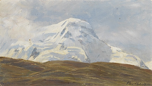
LYSKAMM PAINTED BY BLANCHE BERTHOUD


http://wanderingvertexes.blogspot.com

BLANCHE BERTHOUD (1864 -1938)
Lyskamm or Silberbast (4,527 m - 14,852 ft)
Switzerland - Italy border 

In blick auf den Liskamm, 1900

The mountain 
Lyskamm (4,527 m - 14,852 ft) which means literally "comb of the Lys", also known as Silberbast (literally "silver bast"), is a mountain in the Pennine Alps lying on the border between Switzerland and Italy. It consists of a five-kilometre-long ridge with two distinct peaks. The mountain has gained a reputation for seriousness because of the many cornices lying on the ridge and the frequent avalanches, thus leading to its nickname the Menschenfresser ("people eater"). Because of its modest prominence (376 m), Liskamm is sometimes considered to be part of the extended Monte Rosa group (in fact the Dufourspitze is only 107 metres higher). But visually Liskamm is a huge massif, composed of two summits: the Eastern Liskamm and the lower Western Liskamm, separated by a 1 kilometre (0.62 mi) long ridge, both lying on the border between the Swiss canton of Valais (north) and the Italian region of the Aosta Valley (south). The northern side of the mountain is an impressive 1,100 metres (3,600 ft) ice-covered wall, rising up from the Grenzgletscher. The gentler southern side rises only a few hundred metres above the glacier of the same name: Lysgletscher.

The painter 
Blanche Berthoud was a Swiss painter from the region of Neufchatel (Switzerland) who was very active throughout the first half of the 20th century. She was part of the Société romande des femmes peintres  (Romande Society of Women Painter) founded  by the painter Jeanne Lombard (1865-1945) who defended very fiercely mountain women painters, a world often reserved for men. She made several paintings and watercolors of the Breithorn, one of which was acquired by the Museum of Art and History of Neufchatel

2017 - Wandering Vertexes...
by Francis Rousseau 

Friday, March 10, 2017

BOGDA FENG BY NASA LANDSAT 8 MISSION


NASA LANDSAT 8 MISSION (1999-2017)
Bogda Peak (5,445 m -17,864 ft)
China

 Photographed from space on July 11, 2016

The mountain 
Bogda Peak (5,445 m -17,864 ft) or Bogda Feng  (博格达峰) sometimes referred to as Mount Bogda, is the highest mountain in the Bogda Shan range, in the eastern Tian Shan mountains, China.
Bogda Peak is a challenging climb due to its steep relief. Its sides slope at angles of between 70° and 80°. It was first climbed in 1981 by an 11-person team from Kyoto, Japan.
The Bogda Shan ( 博格达山 ) range is part of the eastern Tian Shan mountains, and located in Xinjiang. Administratively, the range forms the border between Dabancheng District to the south and Fukang City and Jimsar County to the north. In all three units, irrigated agriculture is based on the water flowing in streams that starts in the Bogda Shan.

The photo 
Launched on February 11, 2013, Landsat 8 (formerly the Landsat Data Continuity Mission, LDCM) is the future of Landsat satellites. It is collecting valuable data and imagery to be used in agriculture, education, business, science, and government. The Landsat Program provides repetitive acquisition of high resolution multispectral data of the Earth’s surface on a global basis. The data from Landsat spacecraft constitute the longest record of the Earth’s continental surfaces as seen from space. It is a record unmatched in quality, detail, coverage, and value.

Thursday, March 9, 2017

MOUNT ARBEL BY THOMAS KINKADE


THOMAS KINKADE (bn. 1958)
Mount Arbel or Har Arbel  (380 m - 1, 250ft)
Israel 

Painted in 2006 

The mountain 
Mount Arbel  (380 m- 1,250 ft)  in Hebrew הר ארבל‎‎, is a mountain in The Lower Galilee near Tiberias in Israel, with high cliffs, views of Mount Hermon in the Golan Heights, trails to a cave-fortress, and ruins of an ancient synagogue. Mt. Arbel sits across from Mount Nitai; their cliffs were created as a result of the Jordan Rift Valley and the geological faults that produced the valleys.
There are four villages on the mountain: Kfar Zeitim, Arbel, Kfar Hittim, and Mitzpa. The peak, at 181 metres above sea level (380 m above the surrounding area), dominates the surroundings (much of the area is below sea level) and from the lookout atop the mountain, almost all of the Galilee into the Golan Heights including Safed, Tiberias and most of the Sea of Galilee, is visible.
The area was declared a nature reserve in 1967, covering 1400 dunams. The national park (8509 dunams) includes most of Nahal Arbel, that begins near Eilabun and empties into the Sea of Galilee near Migdal. The reserve covers the immediate area around the cliff.
On the south side of the cliff, there is a gradual prolonged climb through agricultural and pasture land and from the peak there is a steep 400 meters drop. From here there are metal handholds driven into the rock to aid those who want to make the climb down to the valley below. Below that are a series of switchbacks that eventually lead to the Bedouin village of Hamaam.
Mt. Arbel, with its 110-metre vertical drop, is the only known mountain in Israel to serve as a base jumping site. A hike to the top of Mount Arbel from the south is included in the Israel National Trail, and an approach from the west is part of the Jesus Trail; the trails converge temporarily at the peak.

The painter 
Thomas Kindade is a american painter born in 1958 in California.
For more about his biography, click his official website 

Wednesday, March 8, 2017

MOUNT MONADNOCK BY ABBOTT HANDERSON THAYER


ABBOTT HANDERSON THAYER (1849 -1921)
Monadnock  mountain  (965m - 3, 125ft) 
United States of America  (New Hampshire)  

1. In Mount Monadnock- Winter Sunrise, 1919
2.  IMount Monadnock- Winter , 1904

The mountain 
Mount Monadnock (965m - 3, 125ft)  or Grand Monadnock is a mountain in the New England state of New Hampshire. It is the most prominent mountain peak in southern New Hampshire and is the highest point in Cheshire County, New Hampshire. It has long been known as one of the most frequently climbed mountains in the world. The word "monadnock" is an Abenaki-derived word used to describe a mountain. Loosely translated it means "mountain that stands alone", although the exact meaning of the word (what kind of mountain) is uncertain. The term was adopted by early settlers of southern New Hampshire and later by American geologists as an alternative term for an Inselberg or isolated mountain. Mount Monadnock is often called Grand Monadnock, to differentiate it from other Vermont and New Hampshire peaks with "Monadnock" in their names. Its official name on federal maps is "Monadnock Mountain".
Both Ralph Waldo Emerson and Henry David Thoreau visited the mountain and wrote fondly of it. Emerson was a frequent visitor, and made the mountain the subject of "Monadnoc", one of his most famous poems. Thoreau visited the mountain four times between 1844 and 1860 and spent a great deal of time observing and cataloging natural phenomena. He is regarded as having written one of the first serious naturalist inventories of the mountain. A bog near the summit of Mount Monadnock and a rocky lookout off the Cliff Walk trail are named after him; another lookout is named after Emerson.
Mount Monadnock is nearly 1,000 feet (300 m) higher than any other mountain peak within 30 miles (48 km) and rises 2,000 feet (610 m) above the surrounding landscape. Mount Monadnock, 62 miles (100 km) northwest of Boston and 38 miles (61 km) southwest of Concord, is located within the towns of Jaffrey and Dublin, New Hampshire.
Monadnock's bare, isolated, and rocky summit provides expansive views. A number of hiking trails ascend the mountain, including the 110-mile (180 km) Metacomet-Monadnock Trail and the 50-mile (80 km) Monadnock-Sunapee Greenway.
The earliest recorded ascent of Mount Monadnock took place in 1725 by Captain Samuel Willard and fourteen rangers under his command who camped at the top and used the summit as a lookout while patrolling for Native Americans. Before the practice came to be frowned upon, many early hikers carved their names in the summit; the earliest such engraving reads "S. Dakin, 1801" and is attributed to a local town clerk. Notable "power hiking" records associated with the mountain include that of Garry Harrington, who hiked to the summit 16 times in a 24-hour period, and Larry Davis, who claimed to have hiked to the summit daily for 2,850 consecutive days (7.8 years).
Monadnock is often claimed to be the second-most frequently climbed mountain in the world, after Mount Fuji in Japan. Monadnock is climbed by 125,000 hikers yearly, while Mount Fuji sees 200,000-300,000 hikers yearly.  However, according to UNESCO, neither mountain comes close in climbing popularity to Tai Shan in China, with more than 2 million visitors a year.

The painter 
Abbott Handerson Thayer was an American artist, naturalist and teacher. As a painter of portraits, figures, animals and landscapes, he enjoyed a certain prominence during his lifetime, and his paintings are represented in the major American art collections. He is perhaps best known for his 'angel' paintings, some of which use his children as models.
During the last third of his life, he worked together with his son, Gerald Handerson Thayer, on a major book about protective coloration in nature, titled Concealing-Coloration in the Animal Kingdom. First published by Macmillan in 1909, then reissued in 1918, it may have had an effect on military camouflage during World War I. However it was roundly mocked by Theodore Roosevelt and others for its assumption that all animal coloration is cryptic. Thayer also influenced American art through his efforts as a teacher, training apprentices in his New Hampshire studio.
Thayer is sometimes referred to as the "father of camouflage". While he did not invent camouflage, he was one of the first to write about disruptive patterning to break up an object's outlines, about masquerade, as when a butterfly mimics a leaf (though here he was anticipated by Bates, Wallace, and Poulton), and especially about countershading.

Tuesday, March 7, 2017

THE KRIPPENSTEIN PAINTED BY JOSEF THOMA


JOSEF THOMA (1828-1899)
 The Krippenstein  (2,108 m - 6,916 ft) 
Austria 

In view from the  Pfaffengföll over Lake Hallstätt, with the Krippenstein in the background.

The mountain 
The Krippenstein (2,108 m - 6,916 ft) is a popular mountain on the northern edge of the Dachstein mountain range in Upper Austria. The Krippenstein has the form of a double summit: the high Krippenstein is located at a distance of 500 meters (1,640ft)  from a very rocky summit of 2,034 m, (667 3ft) which hosts a mast and a pioneer cross. Not far from the main peak, a mountain chapel has been built. The lime floor of the mountain rises directly above Lake Hallstatt (508 m), with a difference in altitude of 1600m over the lake. It was the first of the 2 thousands peaks in Austria where a cable car was developed(in 1947;  the center station of the cable car  going from Obertraun to the southern part of the Dachstein range. In 2007, the two sections between Obertraun and the Krippenstein (Mittelstation Schönbergalm) were renewed for a cost of 10 million euros. The official opening of the renewed Dachstein-Krippensteinbahn took place on 12 January 2008.
In connection with the appointment of the Hallstatt-Dachstein / Salzkammergut region as an UNESCO World Cultural Heritage Site, some new facilities were also built on the Krippenstein. The view over the Dachstein peaks was declared as "World Heritage Views". At the top of the main peak of the Krippenstein, an observation deck was built with a spiral staircase, the "World Heritage Spiral". It has the shape of a ship and is surrounded by sun loungers.

The painter 
Not a lot of  biographical details about this Austrian painter who used to signed his paintings Josef Thoma the Younger or  Josef the Younger Thoma. Josef Thoma was born in 1828 and died in 1899. Many works by the artist have been sold at auction,  at Christie's New York ($15,000), in France, Austria and all over Europe. A pupil of his father and at the Vienna Academy, Josef Thoma was a painter of scenes of hunting, animated landscapes, urban landscapes and mountain. He likes to include water in his compositions. Many of his works, typical of the 19th century Austrian academic style are in the Vienna Museum.

Dear reader of this blog, you can suggest a biography if you know one,  by using the contact form. 

Monday, March 6, 2017

FUJIYAMA / 富士山 (n°33 f) BY HOKUSAI


KATSUSHIKA HOKUSAÏ (1760-1849) 
Fujiyama / 富士山 (3, 776 m -12,389 ft)
Japan

Red Fuji 1829-33, n°33  from the series 36 Views of Mt. Fuji, early print
Ritsumeikan University, Japan

About the 36 Views of Mt Fuji 
Thirty-six Views of Mount Fuji (富嶽三十六景 Fugaku Sanjūrokkei) is a series of landscape prints created by the Japanese ukiyo-e artist Hokusai (1760?1849). The series depicts Mount Fuji from different locations and in various seasons and weather conditions. The original thirty-six prints were so popular that Hokusai expanded the series by ten.
The earliest impressions appear faded when compared to the versions usually seen, but are closer to Hokusai's original conception. The original prints have a deliberately uneven blue sky, which increases the sky's brightness and gives movement to the clouds. The peak is brought forward with a halo of Prussian blue. Subsequent prints have a strong, even blue tone and the printer added a new block, overprinting the white clouds on the horizon with light blue. Later prints also typically employ a strong benigara (Bengal red) pigment, which lent the painting its common name of Red Fuji. The green block colour was recut, lowering the meeting point between forest and mountain slope.
Red Fuji is a second impression of  凱風快晴, South Wind Clear Sky

The artist
Katsushika Hokusai (葛飾 北斎)  was a Japanese artist, ukiyo-e painter and printmaker of the Edo period. He was influenced by such painters as Sesshu, and other styles of Chinese painting. Born in Edo (now Tokyo), Hokusai is best known as author of the woodblock print series Thirty-six Views of Mount Fuji (富嶽三十六景 c. 1831) which includes the internationally recognized print, The Great Wave off Kanagawa, created during the 1820s.
Hokusai created the "Thirty-Six Views of Mt Fuji " both as a response to a domestic travel boom and as part of a personal obsession with Mount Fuji. In this series, Mt Fuji is painted on different meteorological conditions, in different hours of the days, in different seasons and from different places.

The mountain 
This is the legendary Mount Fuji or Fujiyama (富士山).
It is located on Honshu Island and is the highest mountain peak in Japan at 3,776.24 m (12,389 ft). Several names are attributed to it:  "Fuji-san", "Fujiyama" or, redundantly, "Mt. Fujiyama". Usually Japanese speakers refer to the mountain as "Fuji-san".  The other Japanese names for Mount Fuji,  have become obsolete or poetic like: Fuji-no-Yama (ふじの山 - The Mountain of Fuji), Fuji-no-Takane (ふじの高嶺- The High Peak of Fuji), Fuyō-hō (芙蓉峰 - The Lotus Peak), and Fugaku (富岳/富嶽), created by combining the first character of 富士, Fuji, and 岳, mountain.
Mount Fuji is an active stratovolcano that last erupted in 1707–08. Mount Fuji lies about 100 kilometres (60 mi) south-west of Tokyo, and can be seen from there on a clear day.
Mount Fuji's exceptionally symmetrical cone, which is snow-capped several months a year, is a well-known symbol of Japan and it is frequently depicted in art and photographs, as well as visited by sightseers and climbers.
Mount Fuji is one of Japan's Three Holy Mountains (三霊山) along with Mount Tate and Mount Haku. It is also a Special Place of Scenic Beauty and one of Japan's Historic Sites.
It was added to the World Heritage List as a Cultural Site on June 22, 2013. As per UNESCO, Mount Fuji has “inspired artists and poets and been the object of pilgrimage for centuries”. UNESCO recognizes 25 sites of cultural interest within the Mt. Fuji locality. These 25 locations include the mountain itself, Fujisan Hongū Sengen Shrine and six other Sengen shrines, two lodging houses, Lake Yamanaka, Lake Kawaguchi, the eight Oshino Hakkai hot springs, two lava tree molds, the remains of the Fuji-kō cult in the Hitoana cave, Shiraito Falls, and Miho no Matsubara pine tree grove; while on the low alps of Mount Fuji lies the Taisekiji temple complex, where the central base headquarters of Nichiren Shoshu Buddhism is located.


Sunday, March 5, 2017

MONT COUDON PAINTED BY OTHON FRIESZ


OTHON FRIESZ (1879 -1949) 
Mont Coudon  (702 m - 2, 303 ft) 
France (Var) 

The mountain 
Mont Coudon (702 m - 2, 303ft) is one of the three main mountains of a range called Monts Toulonnais in the Var region in the south of France, near the city harbour of Toulon and La Valette-du-Var.  The Monts Toulonnais are the general appellation of the numerous mountains around Toulon. The highest is Mount Caume (804 m-2,638ft), the least high is the massif of Cape Sicié (358 m) -1,174ft). The Monts toulonnais are also composed of the Baou de Quatre Oures, the Gros-Cerveau (The Big Brain), Mount Faron, which is the best known, and finally Mount Coudon. 
The summit of Mont Coudon is banned from access because it houses at its summit the Fort Girardon, a very important military base of the "Mediterranean" Navy. The Alps are visible for many days in the year, especially on strong Mistral wind days during which the weather is clear.  In November and only during one and three days in the year, it is possible to see the Corsican peaks by atmospheric reverberation. The panorama is hidden to the west by Mount Faron and Mount Caume.
The Coudon represents the end of the range of the Monts Toulonnais, which begin in the vicinity of Bandol to finish in a peak on the town of La Valette-du-Var. It is of calcareous constitution. 
The writer George Sand ascended  Mount Coudon on May 21, 1861, and mentions it in his diary, Voyage dit du Midi, as well as in the work Tamaris. The ascent is 6.1 km long and has a vertical drop of 438 meters for an average slope of 7.2%.

The painter 
Achille-Émile Othon Friesz who later called himself Othon Friesz, and used to sign his paintings E. Othon Friesz, a native of Le Havre, was a French artist of the Fauvist movement.  While he was at the Lycée, he met his lifelong friend Raoul Dufy. He and Dufy studied at the Le Havre School of Fine Arts in 1895-96 and then went to Paris together for further study. In Paris, Friesz met Henri Matisse, Albert Marquet, and Georges Rouault. Like them, he rebelled against the academic teaching of Bonnat and became a member of the Fauves, exhibiting with them in 1907. The following year, Friesz returned to Normandy and to a much more traditional style of painting, since he had discovered that his personal goals in painting were firmly rooted in the past. He opened his own studio in 1912 and taught until 1914 at which time he joined the army for the duration of the war. He resumed living in Paris in 1919 and remained there, except for brief trips to Toulon and the Jura Mountains, until his death in 1949. During the last thirty years of his life, he painted in a style very far from that of his earlier colleagues and his contemporaries. Having abandoned the lively arabesques and brilliant colors of his Fauve years, Friesz returned to the more sober palette he had learned in Le Havre from his professor Charles Lhuillier and to an early admiration for Poussin, Chardin, and Camille Corot. He painted in a manner that respected Paul Cézanne's ideas of logical composition, simple tonality, solidity of volume, and distinct separation of planes. A faint baroque flavor adds vigor to his  landscapes, still lifes, and figure paintings.

Saturday, March 4, 2017

MOUNT UGO PAINTED BY FERNANDO AMORSOLO


http://wanderingvertexes.blogspot.com

FERNANDO AMORSOLO (1882-1972)
Mount Ugo (2, 150m - 7, 053 ft)
Philippines 

The mountain 
Mount Ugo (2, 150m - 7, 053 ft) sometimes called Mount Ugu, is a mountain located in Province of Nueva Vizcaya, Cagayan Valley, Philippines.  The name “Ugo” was derived from an Ibaloi word “Ugo-an” (“to cut the neck”). This is probably because the mountain was an area where the indigenous used to killed the invading Spaniards by cutting their neck. Contrary to the brutal origin of its name, Mount Ugo can be perceived as a landmark that showcases the people’s culture and beliefs.
Mount Ugo is one of the picturesque mountains of this mountain range. It is one of the most known climbing destinations in the country. Ugo is said to be one of the higher mountains in the Cordillera. At the peak, it presents a spectacular view of other Cordillera mountains, including the 2 of the highest peaks in Luzon (Mt. Pulag and Mt. Tabayoc).
Many mountain-enthusiasts and adventure-seekers have proven that Mt. Ugo is unquestionably a great hiking destination. The climb to Mount Ugo usually takes 2 – 3 days depending on how much you would like to enjoy your trekking. During our time, we allotted 3 days for the entire climb.

The painter
Fernando Cueto Amorsolo was one of the most important artists in the history of painting in the Philippines.Amorsolo was a portraitist and painter of rural Philippine landscapes. He is popularly known for his craftsmanship and mastery in the use of light...
- More about Fernando Amorsolo 

2017 - Wandering Vertexes...

by Francis Rousseau 

Friday, March 3, 2017

THE SASSOLUNGO IN VINTAGE POSTCARD 1930


VINTAGE POSTCARDS
The Sassolungo (3, 181m - 10,436 ft)
  Italy 

 Photo by Fotografia Ghedina, Cortina d'Ampezzo. Circa 1930's.

The Mountain
The Sassolungo (3, 181m - 10,436 ft) which means literally "Long Stone", also known as Langkofel in German is a summit of the Alps, in the Dolomites (Trentino-Alto Adige). The Sassolungo is a complex mountain with high slopes and many secondary summits : Sasso Levante or Punta Grohmann (3,126 m -10,256 ft) ;  Punta delle Cinque Dita or Fünffingerspitze (2,998 m - 9,8360 ft) ; Sasso Piatto  or Plattkofel (2,958 m - 9,7080 ft) and Campanile Comici.
Climbing
- 1869 - First climb by Paul Grohmann, Franz Innerkofler and Peter Salcher
- 1890 - First ascent of the Punta delle Cinque Dita by Robert Hans Schmitt and Johann Santner
- 1936 - North face by Gino Soldá and Augusto Bertoldi
- 1940 - North Pillar by E. Esposito and G. Butta
- 1940 - Ascension of Campanile Comici by Emilio Comici and Severino Casara
- 1959 - South Face of Torre Innerkofler by Dietrich Hasse and Sepp Schrott

Vintage postcards
Postcards became popular at the turn of the 20th century, especially for sending short messages to friends and relatives. They were collected right from the start, and are still sought after today by collectors of pop culture, photography, advertising, wartime memorabilia, local history, and many other categories.
Postcards were an international craze, published all over the world. The Detroit Publishing Co. and Teich & Co. were two of the major publishers in the U.S, and sometimes individuals printed their own postcards as well. Yvon were the most famous in France. Many individual or anonymous publishers did exist around the world and especially in Africa and  Asia (Japan, Thailand, Nepal, China, Java) between 1920 and 1955. These photographer were mostly local notables, soldiers, official guides belonging to the colonial armies (british french, belgium...) who sometimes had rather sophisticated equipment and readily produced colored photograms or explorers, navigators, climbers (Vittorio Sella and the Archiduke of Abruzzi future king of Italy remains the most famous of them).
There are many types of collectible vintage postcards.
Hold-to-light postcards were made with tissue paper surrounded by two pieces of regular paper, so light would shine through. Fold-out postcards, popular in the 1950s, had multiple postcards attached in a long strip. Real photograph postcards (RPPCs) are photographs with a postcard backing.
Novelty postcards were made using wood, aluminum, copper, and cork. Silk postcards–often embroidered over a printed image–were wrapped around cardboard and sent in see-through glassine paper envelopes; they were especially popular during World War I.
In the 1930s and 1940s, postcards were printed on brightly colored paper designed to look like linen.
Most vintage postcard collectors focus on themes, like Christmas, Halloween, portraits of movie stars, European royalty and U.S. presidents, wartime imagery, and photos of natural disasters or natural wonders. Not to mention cards featuring colorful pictures by famous artists like Alphonse Mucha, Harrison Fisher, Ellen Clapsaddle, and Frances Brundage.


Thursday, March 2, 2017

NU'UANU PALI PAINTED BY JULES TAVERNIER


JULES TAVERNIER (1844-1889) 
Nuʻuanu Pali ( 356 m - 1,168ft)
United States of America  (Hawaii)

 In View of the Pali', 1886, Honolulu Museum of Art 

The mountain
Nuʻuanu Pali is a section of the windward cliff (Pali in Hawaiian) of the Koʻolau mountain located at the head of Nuʻuanu Valley on the island of Oʻahu. It has a panoramic view of the windward (northeast) coast of Oʻahu. The Pali Highway (Hawaii State Highway 61) connecting Kailua/Kāneʻohe with downtown Honolulu runs through the Nuʻuanu Pali Tunnels bored into the cliffside. The area is also the location of the Nuʻuanu Freshwater Fish Refuge and the Nuʻuanu Reservoir  in the jurisdiction of the Hawaiʻi Department of Land and Natural Resources.
The Nuʻuanu Pali State Wayside is a lookout above the tunnels where there is a panoramic view of the Oʻahu's windward side with views of Kāneʻohe, Kāneʻohe Bay, and Kailua. It is also well known for strong trade winds that blow through the pass (now bypassed by the Nuʻuanu Pali Tunnels).
Two large stones near the back of Nuʻuanu Valley, Hapuʻu and Ka-lae-hau-ola, were said to represent a pair of goddesses who were guardians of the passage down the pali. Travellers would leave offerings of flowers or kapa (bark cloth) to ensure a safe trip, and parents buried the umbilical cords of newborns under the stones as a protection against evil. It is said there is a moʻo wahine (lizard woman) who lingers around the pass. A moʻo wahine is mythical creature who takes the form of a beautiful woman and leads male travelers to their deaths off the cliff.

The painter 
Jules Tavernier was a French painter, illustrator, and an important member of Hawaii’s Volcano School.  He studied with the French painter, Félix Joseph Barrias (1822–1907). he left France in the 1870s and never  return. Tavernier was employed as an illustrator by Harper's Magazine, which sent him, along with Paul Frenzeny, on a year-long coast-to-coast sketching tour in 1873....
More informations aboutJules Tavernier life and works 


Wednesday, March 1, 2017

IAPETUS RIDGE BY NASA CASSINI MISSION


NASA CASSINI MISSION (1997-2017)
Iapetus equatorial ridge (20,000 m - 65,6168 ft)  or (20 km - 12, 43 mi)
Saturn planet (Iapetus moon) 

1. Iapetus equatorial ridge on 10/09/2007 
2. Photomosaic of the Iapetus moon  from NASA Cassini Spacecraft  on 31/12/2004
Assembled by Matt McIrvin  

The mountain 
Iapetus is one of the numerous Saturn's moon which has a 10 to 20 kilometers high (20,000 m - 65,6168 ft)  ridge above the surrounding plains, running along most of its equator, making them some of the tallest mountains in the Solar System.  Iapetus's equatorial ridge was discovered when the NASA Cassini spacecraft imaged Iapetus on 31 December 2004, during the NASA Cassini Mission to Saturn.  The ridge forms a complex system including isolated peaks, segments of more than 200 km and sections with three near parallel ridges. There are bright areas on the sides of the equatorial ridge near Iapetus's bright trailing hemisphere, which were already visible in Voyager Missions images appearing like mountains and were nicknamed the "Voyager Mountains". Within the bright regions there is no ridge, but there are a series of isolated 10 km (6 miles) peaks along the equator. The ridge system is heavily cratered, indicating that it is ancient. 
The prominent equatorial bulge gives Iapetus a walnut-like appearance. 
It is not clear how the ridge formed. One difficulty is to explain why it follows the equator almost perfectly. There are at least four current hypotheses, but none of them explains why the ridge is confined to Cassini Regio.
1. A team of scientists associated with the Cassini mission have argued that the ridge could be a remnant of the oblate shape of the young Iapetus, when it was rotating more rapidly than it does today.  The height of the ridge suggests a maximum rotational period of 17 hours. 
2. The ridge could be icy material that welled up from beneath the surface and then solidified. 
3. Iapetus may have had a ring system during its formation due to its large Hill sphere, and the equatorial ridge could have then been produced by collisional accretion of this ring.
4. The ridge and the bulge could be the result of ancient convective overturn. This hypothesis states that the bulge is in isostatic equilibrium typical for terrestrial mountains. 
Source:

The Mission
Cassini sails low over the surface of Iapetus on approach to its close encounter with the enigmatic moon on Sept. 10, 2007. Its flight takes it over the rugged, mountainous ridge along the moon's equator, where ancient, impact battered peaks - some topping 10 kilometers (6 miles) in height -- are seen rising over the horizon and slipping beneath the spacecraft as it flies.
Frames used in this movie were acquired with the Cassini wide-angle camera on Sept. 10, 2007, as the intrepid robot soared past Iapetus (1,468 kilometers - 912 miles across), within a few thousand kilometers of the surface. Additional simulated images were inserted between the Cassini images in this movie in order to smooth the appearance of the movement, a scheme called interpolation.
The Cassini mission was launched on  October 15, 1997 at 8:43 UTC. This 20 years mission was programmed to end on September 15, 2017 by what is called The Grande Finale.
Source:
NASA Cassini mission Page at Iapetus