google.com, pub-0288379932320714, DIRECT, f08c47fec0942fa0 GRAVIR LES MONTAGNES... EN PEINTURE: Search results for Wilson
Showing posts sorted by relevance for query Wilson. Sort by date Show all posts

Saturday, November 28, 2020

WICK MOUNTAINS PAINTED BY LAURENCE WILLIAM WILSON

 https://wanderingvertexes.blogspot.com/2020/11/wick-mountains-painted-by-laurence.html

LAURENCE WILLIAM  WILSON  (1851-1912),
Wick Mountains (993 m - 3,259 ft)
New Zealand

In Wick Mountains upper Arthur River, watercolor,  TePapa Tongarewa Museum of New Zealand


The mountains
The Wick Mountains lie between the Arthur, Cleddau, and Clinton Valleys. This includes the peaks on the west of the Cleddau Valley, from Mt Moir to Sheerdown Peak. That is where they are provisionally placed on this site. The peaks near Homer Saddle – Mt Moir, Moir’s Mate, and the Mateʻs Little Brother – contain a wealth of classic rock routes on amazing diorite. The close proximity of this region to the road makes the routes accessible as day climbs from Homer Hut. Many routes lie on north to west faces, receiving their first rays of sun in the late morning.

The painter
Laurence William Wilson emigrated to Auckland in 1877 and then travelled extensively to settle in Dunedin in 1884. He painted in both oils and watercolours, became a painting companion of George O'Brien and a teacher. One of his pupils was the Dunedin artist Alfred O'Keefe. In 1895, LW Wilson together with Grace Joel, Alfred O'Keefe, Jane Wimperis and Girolami Nerli formed the Easel Club , a breakaway from the Dunedin Establishment, which offered a programme of special classes and the introduction of a professional lady model for life drawing. In 1904 LW Wilson left Dunedin for Melbourne where he spent 5 months on a commissioned painting of the city before he set out for England, eventually returning to New Zealand via India and Africa. He exhibited with the Canterbury Society of Arts in 1882 and the Otago Art Society between 1994 and 1904. His work was included in the NZ and South Seas Exhibition Dunedin 1889-90 and at the St Louis Exposition in 1904. LW Wilson is represented in the collections of all the major public galleries in New Zealand.

___________________________________________

2020 - Wandering Vertexes...
by Francis Rousseau

Sunday, May 31, 2020

MOUNT TUTOKO PAINTED BY LAURENCE WILLIAM WILSON


LAURENCE WILLIAM  WILSON  (1851-1912)
Mount Tutoko  (2,723 m -8,934 ft) 
New Zealand (South Island)
 In  Mount Tutoko from Pykes River, Martins Bay Oil on canvas, 1900, Private collection 


The mountain
Mount Tutoko (2,723 m -8,934 ft)  is the highest peak in Fiordland National Park, in southwest New Zealand. It lies between the Hollyford Valley and Milford Sound, 15 kilometres due north of the Homer Tunnel at the northern end of the Darran Mountains. The glacier-covered mountain is visible from the Hollyford Track. Two slightly lower summits lie just to the south of the main peak. The first ascent of Tutoko was by Samuel Turner and Peter Graham in 1924, climbing by way of the northwest ridge. The mountain is thought to have been named after Tutoko, a Māori chief who lived at Martin's Bay, close to the mouth of the Hollyford River.

The painter

Laurence William Wilson emigrated to Auckland in 1877 and then travelled extensively to settle in Dunedin in 1884. He painted in both oils and watercolours, became a painting companion of George O'Brien and a teacher. One of his pupils was the Dunedin artist Alfred O'Keefe. In 1895, LW Wilson together with Grace Joel, Alfred O'Keefe, Jane Wimperis and Girolami Nerli formed the Easel Club , a breakaway from the Dunedin Establishment, which offered a programme of special classes and the introduction of a professional lady model for life drawing. In 1904 LW Wilson left Dunedin for Melbourne where he spent 5 months on a commissioned painting of the city before he set out for England, eventually returning to New Zealand via India and Africa. He exhibited with the Canterbury Society of Arts in 1882 and the Otago Art Society between 1994 and 1904. His work was included in the NZ and South Seas Exhibition Dunedin 1889-90 and at the St Louis Exposition in 1904. LW Wilson is represented in the collections of all the major public galleries in New Zealand.

___________________________________________
2020 - Wandering Vertexes...
by Francis Rousseau

Monday, July 20, 2020

MOUNT EARNSLAW / PIKIRAKATAHI BY LAURENCE WILLIAM WILSON


LAURENCE WILLIAM  WILSON  (1851-1912),
Mount Earnslaw / Pikirakatahi  (2,819m -9,249 ft)
New Zealand 

In  Mount Earnslaw, 1887,   oil on canvas., 84x120cm

The mountain 
Mount Earnslaw, (2,819m -9,249 ft) also named Pikirakatahi by Māori is located on New Zealand's South Island. It is named after Earnslaw (formerly Herneslawe) village in the parish of Eccles, Berwickshire, hometown of the surveyor John Turnbull Thomson's father.
Mount Earnslaw is within Mount Aspiring National Park at the southern end of the Forbes Range of New Zealand's Southern Alps. It is located 25 kilometres north of the settlement of Glenorchy, which lies at the northern end of Lake Wakatipu.

The painter
Laurence William Wilson emigrated to Auckland in 1877 and then travelled extensively to settle in Dunedin in 1884. He painted in both oils and watercolours, became a painting companion of George O'Brien and a teacher. One of his pupils was the Dunedin artist Alfred O'Keefe. In 1895, LW Wilson together with Grace Joel, Alfred O'Keefe, Jane Wimperis and Girolami Nerli formed the Easel Club , a breakaway from the Dunedin Establishment, which offered a programme of special classes and the introduction of a professional lady model for life drawing. In 1904 LW Wilson left Dunedin for Melbourne where he spent 5 months on a commissioned painting of the city before he set out for England, eventually returning to New Zealand via India and Africa. He exhibited with the Canterbury Society of Arts in 1882 and the Otago Art Society between 1994 and 1904. His work was included in the NZ and South Seas Exhibition Dunedin 1889-90 and at the St Louis Exposition in 1904. LW Wilson is represented in the collections of all the major public galleries in New Zealand.

___________________________________________

2020 - Wandering Vertexes...
by Francis Rousseau


Tuesday, December 8, 2020

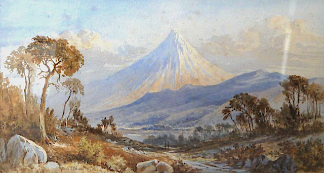
TARANAKI / MOUNT EGMONT PAINTED BY LAURENCE WILLIAM WILSON

https://wanderingvertexes.blogspot.com/2020/12/taranaki-mount-egmont-painted-by.html
 
 
LAURENCE WILLIAM WILSON (1851-1912)
Taranaki /Mount Egmont (2,518 m - 8,261 ft)
New Zealand (Northen Island)

The mountain
Taranaki or Mount Egmont (2,518 m - 8,261 ft) is an active but quiescent stratovolcano in the Taranaki region on the west coast of New Zealand's North Island. Although the mountain is more commonly referred to as Taranaki, it has two official names under the alternative names policy of the New Zealand Geographic Board. The mountain is one of the most symmetrical volcanic cones in the world. There is a secondary cone, Fanthams Peak or Panitahi in Māori (1,966 m - 6,450 ft), on the south side. Because of its resemblance to Mount Fuji, Taranaki provided the backdrop for the movie The Last Samurai.
For many centuries the mountain was called Taranaki by Māori. The Māori word tara means mountain peak, and naki is thought to come from ngaki, meaning "shining", a reference to the snow-clad winter nature of the upper slopes. It was also named Pukehaupapa and Pukeonaki by Iwi who live in the region in ancient times.
According to Māori mythology, Taranaki once resided in the middle of the North Island, with all the other New Zealand volcanoes. The beautiful Pihanga was coveted by all the mountains, and a great battle broke out between them. Tongariro eventually won the day, inflicted great wounds on the side of Taranaki, and causing him to flee. Taranaki headed westwards, following Te Toka a Rahotu and forming the deep gorges of the Whanganui River, paused for a while, creating the depression that formed the Te Ngaere swamp, then heading north. Further progress was blocked by the Pouakai ranges, and as the sun came up Taranaki became petrified in his current location. When Taranaki conceals himself with rainclouds, he is said to be crying for his lost love, and during spectacular sunsets, he is said to be displaying himself to her. In turn, Tongariro's eruptions are said to be a warning to Taranaki not to return.
Captain Cook named it Mount Egmont on 11 January 1770 after John Perceval, 2nd Earl of Egmont, a former First Lord of the Admiralty who had supported the concept of an oceanic search for Terra Australis Incognita. Cook described it as "of a prodigious height and its top cover'd with everlasting snow" surrounded by a "flat country ... which afforded a very good aspect, being clothed with wood and verdure".
When Marc-Joseph Marion du Fresne made landfall off Taranaki on 25 March 1772 he named the mountain Pic Mascarin. He was unaware of Cook's earlier visit. It appeared as Mount Egmont on maps until 29 May 1986, when the Minister of Lands ruled that "Mount Taranaki" would be an alternative and equal official name. The Egmont name still applies to the national park that surrounds the peak and geologists still refer to the peak as the Egmont Volcano.
Taranaki is geologically young, having commenced activity approximately 135,000 years ago. The most recent volcanic activity was the production of a lava dome in the crater and its collapse down the side of the mountain in the 1850s or 1860s. Between 1755 and 1800, an eruption sent a pyroclastic flow down the mountain's northeast flanks, and a moderate ash eruption occurred about 1755, of the size of Ruapehu's activity in 1995/1996. The last major eruption occurred around 1655. Recent research has shown that over the last 9,000 years minor eruptions have occurred roughly every 90 years on average, with major eruptions every 500 years.

The painter
Laurence William Wilson emigrated to Auckland in 1877 and then travelled extensively to settle in Dunedin in 1884. He painted in both oils and watercolours, became a painting companion of George O'Brien and a teacher. One of his pupils was the Dunedin artist Alfred O'Keefe. In 1895, LW Wilson together with Grace Joel, Alfred O'Keefe, Jane Wimperis and Girolami Nerli formed the Easel Club , a breakaway from the Dunedin Establishment, which offered a programme of special classes and the introduction of a professional lady model for life drawing. In 1904 LW Wilson left Dunedin for Melbourne where he spent 5 months on a commissioned painting of the city before he set out for England, eventually returning to New Zealand via India and Africa. He exhibited with the Canterbury Society of Arts in 1882 and the Otago Art Society between 1994 and 1904. His work was included in the NZ and South Seas Exhibition Dunedin 1889-90 and at the St Louis Exposition in 1904. LW Wilson is represented in the collections of all the major public galleries in New Zealand.

___________________________________________

2020 - Wandering Vertexes...
by Francis Rousseau

Wednesday, February 12, 2020

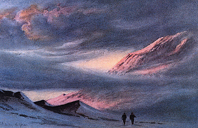
MOUNT EREBUS (5) BY EDWARD ADRIAN WILSON


EDWARD ADRIAN WILSON (1872-1912)
Mount Erebus (3, 794 m - 12, 448ft)
Antarctica

In Slopes of Mount Erebus,  Watercolour on paper laid down on card Painting, 13.3 x 21.6 cm, 1911,  Royal Geographical Society Museum, London

The mountain 
Mount Erebus (3, 794 m - 12, 448ft), not to be confused with Mount Elbrus is the second-highest volcano in Antarctica (after Mount Sidley) and the southernmost active volcano on Earth. It is the sixth highest ultra mountain on an island, located on Ross Island, which is also home to three inactive volcanoes:  Mount Terror, Mount Bird, and Mount Terra Nova.
The volcano has been active since c. 1.3 million years ago and is the site of the Mount Erebus Volcano Observatory run by the New Mexico Institute of Mining and Technology.
Mount Erebus was discovered on January 27, 1841 (and observed to be in eruption) by polar explorer Sir James Clark Ross who named it and its companion, Mount Terror, after his ships, Erebus and Terror (which were later used by Sir John Franklin on his disastrous Arctic expedition). 
The artist
Edward Adrian Wilson,  nicknamed "Uncle Bill" was an English physician, polar explorer, natural historian, painter and ornithologist. Wilson took part in two British expeditions to Antarctica, the Discovery Expedition (1901-1904)  and the tragic Terra Nova Expedition (1907-1912), both under the leadership of Scott.
_______________________________ 

2020 - Wandering Vertexes..
Un blog de Francis Rousseau


Wednesday, August 16, 2023

LE MONT KIRKPATRICK PEINT PAR EDWARD ADRIAN WILSON


EDWARD ADRIAN WILSON (1872-1912), Mont Kirkpatrick  (4,528m) Antarctique  (Ile de Ross)   In "Sunset from Hut Point April 2nd 1911 ,watercolor


EDWARD ADRIAN WILSON (1872-1912)
Mont Kirkpatrick  (4,528m)
Antarctique  (Ile de Ross)

In "Sunset from Hut Point", April 2nd 1911, watercolor 


La montagne
Le mont Kirkpatrick est le point culminant du chaînon de la Reine-Alexandra, en Antarctique. Situé à 8 kilomètres à l'ouest du mont Dickerson, le mont Kirkpatrick est aussi le point culminant de la chaîne Transantarctique. Découvert et nommé par l'expédition Nimrod en 1908-1909, la montagne doit son nom à un homme d'affaires de Glasgow, qui était l'un des sponsors de l'expédition.
Sur les pentes du mont Kirkpatrick se trouve l'un des plus importants sites paléontologiques de l'Antarctique : la formation de Hanson, datée du Jurassique inférieur. À cette période, l'Antarctique était plus chaud et faisait partie due l'unique supercontinent qeu compteaut la planete et que l'on nomme Pangée. Ceci explique pourquoi les fossiles trouvés sur ce site peuvent l'être partout ailleurs dans le monde. À plus de 4 000 mètres d'altitude, des restes fossiles de vertébrés y ont été découverts, dont ceux du premier dinosaure trouvé sur le continent, Cryolophosaurus ellioti, nommé en 1994. Une autre espèce de dinosaures, Glacialisaurus hammeri, a été découverte durant une campagne de recherche en 2003-2004. Ce site a également livré les restes d'un cynodonte de la famille des tritylodontidés et un humérus de ptérosaure

 
Le peintre
Edward Adrian Wilson, surnommé « oncle Bill », est un explorateur polaire britannique, médecin, naturaliste, peintre et ornithologue.
Il fait partie des expéditions polaires Discovery et Terra Nova de Robert Falcon Scott. Il trouve la mort, lors de cette dernière, avec toute l'équipe de Scott composée de cinq hommes, en revenant du pôle Sud où ils avaient découvert qu'Amundsen et ses hommes les avaient précédés.

 ________________________________________

2023 - Gravir les montagnes en peinture
Un blog de Francis Rousseau


Wednesday, March 11, 2020

MOUNT EREBUS (5) BY EDWARD ADRIAN WILSON


EDWARD ADRIAN WILSON (1872-1912)
Mount Erebus (3, 794 m - 12, 448ft)
Antarctica (Ross Island)

 In  Mountain range, McMurdo Strait, watercolor, 7.4 x 11.3 cm, Private collection 


The mountain
Mount Erebus (3, 794 m - 12, 448ft), not to be confused with Mount Elbrus is the second-highest volcano in Antarctica (after Mount Sidley) and the southernmost active volcano on Earth. It is the sixth highest ultra mountain on an island, located on Ross Island, which is also home to three inactive volcanoes: Mount Terror, Mount Bird, and Mount Terra Nova.
More about the mountain

The artist
Edward Adrian Wilson, nicknamed "Uncle Bill" was an English physician, polar explorer, natural historian, painter and ornithologist. Wilson took part in two British expeditions to Antarctica, the Discovery Expedition (1901-1904) and the tragic Terra Nova Expedition (1907-1912), both under the leadership of Scott.
More about the artist 

_______________________________ 

2020 - Wandering Vertexes...
by Francis Rousseau


Tuesday, January 14, 2020

MOUNT EREBUS (2) BY EDWARD ADRIAN WILSON


EDWARD ADRIAN WILSON (1872-1912)
Mount Erebus (3, 794 m - 12, 448ft)
Antarctica

 In  Mt Erebus - Aug. 17. 1911 - Noon.' on the mount,  Watercolour on paper, 13.1 x 21.1cm, 
Private collection (via Christie's)

About this watercolour
'The Summit of Mount Erebus' taken in August 1911, facing p.150.
Very similkar to  Mount Erebus 1911, watercolour,  Museum- Royal Geographical Society,
Notes :
"Thursday, August 17. - The weather has been extremely kind to us of late; we haven't a single grumble against it. Th temperature hovers pretty constantly at about -35°, there is very little wind and the sky is clear and bright. In such weather one sees well for more than three hours before and after noon, the landscape unfolds itself, and the sky colours are always delicate and beautiful. At noon today there was bright sunlight on the tops of the Western Peaks and on the summit and steam of Erebus -- of late the vapour cloud of Erebus has been exceptionally heavy and fantastic in form."

About Mount Erebus 

About the artist  


_______________________________

2020 - Wandering Vertexes.
Un blog de Francis Rousseau

Saturday, January 14, 2017

MOUNT LAFAYETTE PAINTED BY ALBERT BIERSTADT


ALBERT BIERSTADT (1830-1902) 
Mount Lafayette (1,600m - 5,249 ft) 
United State of America 

The Mountain 
Mount Lafayette (1,600m - 5,249 ft)  is a mountain at the northern end of the Franconia Range in the White Mountains of New Hampshire, United States. It is located in the town of Franconia in Grafton County. It is on the New England Fifty Finest list of the most topographically prominent peaks in New England. The upper portion of the mountain is located in the alpine zone, an area where only small vegetation exists due to the harsh climate.
The mountain is named to honor General Lafayette, a French military hero of the 18th century who fought with and significantly aided the Continental Army and was loved and adopted by George Washington during the American Revolutionary War. Lafayette re-visited New Hampshire and all the other states in an extremely popular, triumphal tour during 1824-1825, celebrating the 50th anniversary of the Battle of Bunker Hill.
Mount Lafayette is the highest point in the Franconia Range, a line of peaks along the east side of Franconia Notch. It is the sixth highest peak in New Hampshire and the highest outside of the Presidential Range. It is the second most prominent peak in the state. On the western side, its lower slopes lie inside Franconia Notch State Park. The remainder of the mountain lies within the White Mountain National Forest. The summit marks the western border of the Pemigewasset Wilderness Area within the WMNF.

The painter 
Albert Bierstadt was a German-born American painter. He was brought to the United States at the age of one by his parents. He later returned to study painting for several years in Düsseldorf. At an early age Bierstadt developed a taste for art and made clever crayon sketches in his youth. 
In 1851, he began to paint in oils. He became part of the Hudson River School in New York, an informal group of like-minded painters who started painting along this scenic river. Their style was based on carefully detailed paintings with romantic, almost glowing lighting, sometimes called luminism. An important interpreter of the western landscape, Bierstadt, along with Thomas Moran, is also grouped with the Rocky Mountain School.
In 1858 he exhibited a large painting of a Swiss landscape at the National Academy of Design, which gained him positive critical reception and honorary membership in the Academy.  At this time Bierstadt began painting scenes in New England and upstate New York, including in the Hudson River valley. A group of artists known as the Hudson River School portrayed its majestic landscapes and craggy areas, as well as the light affected by the changing waters.
In 1859, Bierstadt traveled westward in the company of Frederick W. Lander, a land surveyor for the U.S. government, to see those landscapes.  He continued to visit the American West throughout his career.
During the American Civil War, Bierstadt paid for a substitute to serve in his place when he was drafted in 1863. He completed one Civil War painting Guerrilla Warfare, Civil War in 1862, based on his brief experiences with soldiers stationed at Camp Cameron in 1861.
Bierstadt's painting was based on a stereoscopic photograph taken by his brother Edward Bierstadt, who operated a photography studio at Langley's Tavern in Virginia. Bierstadt's painting received a positive review when it was exhibited at the Brooklyn Art Association at the Brooklyn Academy of Music in December 1861. Curator Eleanor Jones Harvey observes that Bierstadt's painting, created from photographs, "is quintessentially that of a voyeur, privy to the stories and unblemished by the violence and brutality of first-hand combat experience."
In 1860, he was elected a member of the National Academy; he received medals in Austria, Bavaria, Belgium, and Germany.[ In 1867 he traveled to London, where he exhibited two landscape paintings in a private reception with Queen Victoria. He traveled through Europe for two years, cultivating social and business contacts to sustain the market for his work overseas.
As a result of the publicity generated by his Yosemite paintings, Bierstadt's presence was requested by every explorer considering a westward expedition, and he was commissioned by the Atchison, Topeka, and Santa Fe Railroad to visit the Grand Canyon for further subject matter.
Bierstadt's technical proficiency, earned through his study of European landscape, was crucial to his success as a painter of the American West. It accounted for his popularity in disseminating views of the Rockies to those who had not seen them. The immense canvases he produced after his trips with Lander and Ludlow established him as the preeminent painter of the western American landscape. 
Despite his popular success, Bierstadt was criticized by some contemporaries for the romanticism evident in his choices of subject and his use of light was felt to be excessive. 
In 1882 Bierstadt's studio at Irvington, New York, was destroyed by fire, resulting in the loss of many of his paintings. By the time of his death on February 18, 1902, the taste for epic landscape painting had long since subsided. Bierstadt was then largely forgotten. He was buried at the Rural Cemetery in New Bedford, Massachusetts.
Interest in his work was renewed in the 1960s, with the exhibition of his small oil studies. The subsequent reassessment of Bierstadt's work has placed it in a favorable context.
Bierstadt's theatrical art, fervent sociability, international outlook, and unquenchable personal energy reflected the epic expansion in every facet of western civilization during the second half of the nineteenth century. Bierstadt was a prolific artist, having completed over 500 paintings during his lifetime. Many of these are held by museums across the United States.
Several mountain paintings by Bierstadt are published in this blog.  To find them, go to his name in the column on the right and just click on his name.
Sources: 

Wednesday, June 10, 2020

BEN NEVIS PAINTED BY JAMES ALFRED AÏIKEN


JAMES ALFRED AITKEN (1846-1897)
Ben Nevis (1,344 m - 4, 118 ft)
United KIngdom  (Scotland)

In  Ben Nevis- The First Snow, Glasgow Museums Resource Centre


The mountain 
Ben Nevis  (1,344 m - 4, 118 ft)  in Scottish Gaelic: Beinn Nibheis is the highest mountain in the British Isles, located in Scotland, at the western end of the Grampian Mountains in the Lochaber area of the Scottish Highlands, close to the town of Fort William.
The mountain is a popular destination, attracting an estimated 100,000 ascents a year, around three-quarters of which use the Pony Track from Glen Nevis. The 700 metre - 2,300 ft cliffs of the north face are among the highest in Scotland, providing classic scrambles and rock climbs of all difficulties for climbers and mountaineers. They are also the principal locations in Scotland for ice climbing.
The summit, which is the collapsed dome of an ancient volcano, features the ruins of an observatory which was continuously staffed between 1883 and 1904. The meteorological data collected during this period are still important for understanding Scottish mountain weather. C. T. R. Wilson was inspired to invent the cloud chamber after a period spent working at the observatory.
More about Ben Nevis 

The painter
James Alfred Aitken was a Scottish landscape painter.
Aitken studied art with Horatio McCulloch, before moving to Dublin. There he attended the Royal Dublin Society's school, and had Henry MacManus as teacher.]
In 1872 Aitken moved to Glasgow. He exhibited at the Royal Academy, Glasgow Institute and Royal Hibernian Academy.


___________________________________

2020 - Wandering Vertexes...
by Francis Rousseau


Saturday, September 9, 2017

KILAUEA PAINTED BY AMBROSE PATTERSON


AMBROSE MC CARTHY PATTERSON (1877-1966) 
Mount Kilauea  (1,247 m - 4,091 ft) 
United States of America (Hawaï)  

In Mount Kilauea,  the house of Everlasting Fire, 1917 oil on canvas, Honolulu Museum of Art  

The mountain 
Kilauea (1,247 m - 4,091 ft) is a currently active shield volcano in the Hawaiian Islands, and the most active of the five volcanoes that together form the island of Hawaiʻi. Located along the southern shore of the island, the volcano is between 300,000 and 600,000 years old and emerged above sea level about 100,000 years ago. It is the second youngest product of the Hawaiian hotspot and the current eruptive center of the Hawaiian–Emperor seamount chain. Because it lacks topographic prominence and its activities historically coincided with those of Mauna Loa, Kīlauea was once thought to be a satellite of its much larger neighbor. Structurally, Kīlauea has a large, fairly recently formed caldera at its summit and two active rift zones, one extending 125 km (78 mi) east and the other 35 km (22 mi) west, as an active fault of unknown depth moving vertically an average of 2 to 20 mm (0.1 to 0.8 in) per year.
Kīlauea's eruptive history has been a long and active one; its name means "spewing" or "much spreading" in the Hawaiian language, referring to its frequent outpouring of lava. The earliest lavas from the volcano date back to its submarine preshield stage, samples having been recovered by remotely operated underwater vehicles from its submerged slopes; samples of other flows have been recovered as core samples. Lavas younger than 1,000 years cover 90 percent of the volcano's surface. The oldest exposed lavas date back 2,800 years. The first well-documented eruption of Kīlauea occurred in 1823 (Western contact and written history began in 1778), and since that time the volcano has erupted repeatedly. Most historical eruptions have occurred at the volcano's summit or its eastern rift zone, and are prolonged and effusive in character. The geological record shows, however, that violent explosive activity predating European contact was extremely common, and in 1790 one such eruption killed over 80 warriors; should explosive activity start anew the volcano would become much more of a danger to humans. Kīlauea's current eruption dates back to January 3, 1983, and is by far its longest-duration historical period of activity, as well as one of the longest-duration eruptions in the world; as of January 2011, the eruption has produced 3.5 km3 (1 cu mi) of lava and resurfaced 123.2 km2 (48 sq mi) of land.
Kīlauea's high state of activity has a major impact on its mountainside ecology where plant growth is often interrupted by fresh tephra and drifting volcanic sulfur dioxide, producing acid rains particularly in a barren area south of its southwestern rift zone known as the Kaʻū Desert. Nonetheless, wildlife flourishes where left undisturbed elsewhere on the volcano and is highly endemic thanks to Kīlauea's (and the island of Hawaiʻi's) isolation from the nearest landmass. Historically, the five volcanoes on the island were considered sacred by the Hawaiian people, and in Hawaiian mythology Kīlauea's Halemaumau Crater served as the body and home of Pele, goddess of fire, lightning, wind, and volcanoes. William Ellis, a missionary from England, gave the first modern account of Kīlauea and spent two weeks traveling along the volcano; since its foundation by Thomas Jaggar in 1912, the Hawaiian Volcano Observatory, located on the rim of Kilauea caldera, has served as the principal investigative and scientific body on the volcano and the island in general. In 1916 a bill forming the Hawaii Volcanoes National Park was signed into law by President Woodrow Wilson; since then the park has become a World Heritage Site and a major tourist destination, attracting roughly 2.6 million people annually.

The painter 
Ambrose McCarthy Patterson  was a painter and printmaker, born in Daylesford, Victoria (Australia). He studied at the Melbourne Art School under E. Phillips Fox and Tudor St George Tucker, at the National Gallery Art School in Melbourne and continued his studies in Paris at the Académie Colarossi and the Académie Julian under Lucien Simon, André Lhote and Maxime Maufra. In Paris he became a friend of compatriot Nellie Melba, the famous soprano; Patterson's brother, Tom, was married to Melba's sister, Belle. Through Melba's influence, he was able to continue his studies with John Singer Sargent. He became part of the Paris arts scene and exhibited at the first Salon d'Automne exhibitions. He had five paintings at the 1905 Paris Salon at which Henri Matisse and the fauves stunned the art world.
He arrived in Hawaii in 1916 on a stopover from Sidney to New York, and decided to stay with a Parisian friend living in Honolulu. During the next 18 months, Patterson made block prints and paintings with particular interest in Kilauea. His art was included in the Hawaiian Society of Artists Annual in 1917. He left for California in 1918 and settled in Seattle. At the 1918 Spring Annual of the San Francisco Art Association (SFAA) his wood block prints were said to be "especially fine in color." That summer his art was given a one-man exhibition at the SFAA galleries and he contributed three color prints (The Steeple Chase, The Bull Fight, and The Long Beach) to the Seventh Annual of the California Society of Etchers.
By September 1918 Patterson had moved to Seattle to work as a freelance artist, perhaps being the first modern artist in that city, and that fall his art was given a solo show at the Seattle Fine Arts Society, the first of many exhibitions in Washington State. In 1919 he established the University of Washington School of Painting and Design. Patterson married painter and former student Viola Hansen in 1922, and the two became major figures of the arts in the Pacific Northwest region. Patterson taught until his retirement in 1947. He died in Seattle in 1966 leaving behind an impressive record of awards received and exhibitions across the United States, including the: Art Institute of Chicago, Museum of Modern Art in New York City, National Gallery of Art in Washington, D.C., and the World’s Fairs in San Francisco and New York City.
The Art Gallery of New South Wales (Sydney, Australia), the Honolulu Museum of Art, the National Portrait Gallery (Australia) (Canberra), the Philadelphia Museum of Art, the Seattle Art Museum and the Tacoma Art Museum are among the public collections holding works by Ambrose McCarthy Patterson.

Wednesday, April 26, 2023

LE RIGI PEINT PAR J.M.W. TURNER


J.M.W. TURNER (1775-1851)
Rigi (1 797 m - 5 897 ft)
Suisse

In "Lake Lucerne, with the Rigi" , vers 1840 - 1849, Crayon et aquarelle rehaussé de touches de blanc, 24,8 x 36,2 cm, Collection Privée


La montagne
Le Rigi (1 797 m - 5 897 ft), également connu sous le nom de Reine des montagnes) est un massif montagneux des Alpes, situé en Suisse centrale. L'ensemble du massif est presque entièrement entouré par les eaux de trois plans d'eau différents : le lac des Quatre-Cantons, le lac de Zoug et le lac Lauerz. La chaîne se trouve dans les Alpes de Schwyz et est divisée entre les cantons de Schwyz et de Lucerne, bien que le sommet principal, nommé Rigi Kulm, à 1 798 mètres d'altitude, se trouve dans le canton de Schwyz. Techniquement, le Rigi ne fait pas partie des Alpes et appartient plutôt au plateau suisse. Il est principalement composé de molasse et d'autres conglomérats, par opposition au schiste grison et au flysch des Alpes.
Le Rigi Kulm et d'autres régions, telles que la station balnéaire de Rigi Kaltbad, sont desservies par les plus anciens chemins de fer de montagne d'Europe, les Rigi Railways. Les Chemins de fer suisses proposent une excursion spéciale aller-retour, le "Rigi-Rundfahrt", couvrant plusieurs segments en train, en train à crémaillère, en gondole (en option) et en bateau à vapeur. Toute la région offre de nombreuses activités telles que le ski ou la luge en hiver et la randonnée en été.
Le nom Rigi vient du vieux haut allemand « rîga » qui signifie « rangée, rayure, sillon », d'après la stratification bien visible sur le versant nord de la montagne. Le nom est enregistré pour la première fois en 1350 sous le nom de Riginun. Le nom a été interprété comme Regina montium "reine des montagnes" par Albrecht von Bonstetten (1479), qui donne cependant Rigena comme forme alternative.
Le mont Rigi a été présenté dans de nombreuses œuvres d'art, y compris des peintures et des publications littéraires. Les peintures les plus célèbres du Rigi étaient peut-être la série de J.M.W. Turner dont plusieurs sont dans la collection de la Tate Britain à Londres.


Le peintre
Joseph Mallord William Turner, plus connu sous le nom de William Turner ou de ses initiales J. M. W. Turnera, est un peintre, aquarelliste et graveur britannique,. Initialement de la veine romantique anglaise, son œuvre est marquée par une recherche novatrice audacieuse qui le fait considérer, avec son contemporain John Constable, comme un précurseur de l'impressionnisme, voir même d'une certaine abstraction. Renommé pour ses huiles, Turner est également un des plus grands maîtres anglais de paysages à l'aquarelle. Il y gagne le surnom de « peintre de la lumière ». La plus grande partie des œuvres de Turner est conservée à la Tate Britain. Il efut influencé par des artistes tels que Willem van de Velde le Jeune, Albert Cuyp, John Robert Cozens, Richard Wilson, Claude Gellée (« Claude le Lorrain ») ou encore Nicolas Poussin. Influencé par la Recherche philosophique sur l'origine de nos idées du Sublime et du Beau d'Edmund Burke datée de 1757, Turner intégra le concept du Sublime dans certaines de ses œuvres, à commencer par Bateaux hollandais dans la tempête, mettant en scène un spectacle terrifiant et à la fois délicieux. Il travailla d'abord la gravure avant l'aquarelle puis la peinture. D'après ses propres souvenirs, il fut marquépar une suite de 16 pièces gravées en clair-obscur d'Elisha Kirkall (1722) d'après Van de Velde le Jeune À partir de 1802, l'envie de voyager le conduit sur le continent européen, principalement en France et en Suisse, d'où il rapporte, évidemment, des aquarelles mais aussi le goût pour certains artistes, comme le Lorrain et ses représentations de la mythologie. Turner peint ainsi des fresques antiques comme Didon construisant Carthage en 1815. Il s'inspire aussi du Liber Veritatis du Lorrain en ce qui concerne son ouvrage, Liber Studiorum, établissant ainsi une classification des différents types de paysages : Marine, Montagne, Pastorale, Historique, Architecturale et Pastorale épique. Il n'hésite pas à tester des combinaisons étranges d'aquarelle et d'huile ainsi que de nouveaux produits dans ses toiles.  Parfois, il utilise même des matériaux inhabituels comme le jus de tabac et la bière vieillie, avec pour conséquence la nécessité des restaurations régulières de ses œuvres. Le peintre et critique d'art George Beaumont qualifie Turner et ses suiveurs comme Callcott de « peintres blancs » car ils mettent au point dès le début du 19e siècle l'utilisation d'un fond blanc pour donner à leurs tableaux la fraîcheur des couleurs et la luminosité, permettant le passage direct des effets de l'aquarelle dans la peinture à l'huile, 3 effets tout à fait différents de ceux obtenus avec les fonds rouges ou bruns traditionnels des anciens Maîtres ".
Son passage d'une représentation plus réaliste à des œuvres plus lumineuses, à la limite de l'imaginaire (Tempête de neige en mer), se fait après un voyage en Italie en 1819 (Campo Santo de Venise). Turner montre le pouvoir suggestif de la couleur, ainsi, son attirance pour la représentation des atmosphères le place pour des critiques d'art comme Clive Bell, comme un précurseur de la modernité en peinture et de l'impressionnisme jusqu'à devenir « le peintre des incendies ». Mais il peint rarement sur le motif contrairement aux impressionnistes, qui feront de cette pratique une règle. Il préfère en effet recomposer en atelier les nuances des paysages, aidé de sa grande mémoire des couleurs. D'autres critiques préfèrent pousser plus loin encore leur analyse en voyant dans l'absence de lignes et de points de fuite ou la dissolution de la forme dans la couleur, notamment dans les paysages marins de Turner, les prémices de l'abstraction lyrique, voire de l'action painting en gestation. 


_________________________________________

2023 - Wandering Vertexes ....
Errant au-dessus des Sommets Silencieux...
Un blog de Francis Rousseau


Monday, April 24, 2017

MOUNT ADAMS / PAHTO PAINTED BY ALBERT BIERSTADT


ALBERT BIERSTADT  (1830-1902) 
Mount Adams or Patho or Klikitat (3, 473m - 12, 281ft) 
United States of America (Washington State) 

In Mount Adams , 1875, oil on canvas, Princeton University Art Museum, USA

The mountain
Mount Adams or Patho or Klikitat (3, 473m - 12, 281ft)  is a potentially active stratovolcano in the Cascade Range, USA. Although Adams has not erupted in more than 1,000 years, it is not considered extinct. It is the second-highest mountain in the U.S. state of Washington, after Mount Rainier/Tacoma. Mount Adams is a member of the Cascade Volcanic Arc, and is one of the arc's largest volcanoes, located in a remote wilderness approximately 34 miles (55 km) east of Mount St. Helens. The Mount Adams Wilderness consists of the upper and western part of the volcano's cone. The eastern side of the mountain is designated as part of the territory of the Yakama Nation.
Adams' asymmetrical and broad body rises 1.5 miles (2.4 km) above the Cascade crest. Its nearly flat summit was formed as a result of cone-building eruptions from separated vents. A false summit, Pikers Peak, rises 11,657 feet (3,553 m) on the south side of the nearly half-mile (800 m) wide summit area. The true summit is about 600 feet (180 m) higher on the gently sloping north side. A small lava and scoria cone marks the highest point. Suksdorf Ridge is a long buttress descending from the false summit down to an elevation of 8,000 feet (2,000 m). This structure was built by repeated lava flows in the late Pleistocene. 
Air travelers flying the busy routes above the area sometimes confuse Mount Adams with nearby Mount Rainier/Tacoma, which has a similar flat-topped shape.
The Pacific Crest Trail traverses the western flank of the mountain.
In the early 21st century, glaciers cover a total of 2.5% of Adams' surface. During the last ice age about 90% of the mountain was glaciated. Mount Adams has 209 perennial snow and ice features and 12 officially named glaciers : Adams Glacier, Pinnacle Glacier, White Salmon Glacier,  Avalanche Glacier, Mazama Glacier, Klickitat Glacier, Rusk Glacier, Wilson Glacier, Gotchen Glacier, Crescent Glacier and Lava Glacier.

 The Painter 
Albert Bierstadt was a German-born American painter.At an early age Bierstadt developed a taste for art and made clever crayon sketches in his youth. In 1851, he began to paint in oils. He became part of the Hudson River School in New York, an informal group of like-minded painters who started painting along this scenic river. Their style was based on carefully detailed paintings with romantic, almost glowing lighting, sometimes called Luminism. An important interpreter of the western landscape, Bierstadt, along with Thomas Moran, is also grouped with the Rocky Mountain School.
In 1858 he exhibited a large painting of a Swiss landscape at the National Academy of Design, which gained him positive critical reception and honorary membership in the Academy.  At this time Bierstadt began painting scenes in New England and upstate New York, including in the Hudson River valley. A group of artists known as the Hudson River School portrayed its majestic landscapes and craggy areas, as well as the light affected by the changing waters.
In 1859, Bierstadt traveled westward in the company of Frederick W. Lander, a land surveyor for the U.S. government, to see those landscapes.  He continued to visit the American West throughout his career....
 - More on Albert Bierstadt 's life and works

Wednesday, November 8, 2017

MOUNT ADAMS PAINTED BY ALVAN FISCHER


ALVAN FISCHER (1792-1863)
Mount Adams or Patho or Klikitat (3, 473m - 12, 281ft) 
United States of America (Washington State) 

In Mount Adams from the Peabody, 1857, oil on canvas

The mountain
Mount Adams or Patho or Klikitat (3, 473m - 12, 281ft)  is a potentially active stratovolcano in the Cascade Range, USA. Although Adams has not erupted in more than 1,000 years, it is not considered extinct. It is the second-highest mountain in the U.S. state of Washington, after Mount Rainier/Tacoma. Mount Adams is a member of the Cascade Volcanic Arc, and is one of the arc's largest volcanoes, located in a remote wilderness approximately 34 miles (55 km) east of Mount St. Helens. The Mount Adams Wilderness consists of the upper and western part of the volcano's cone. The eastern side of the mountain is designated as part of the territory of the Yakama Nation.
Adams' asymmetrical and broad body rises 1.5 miles (2.4 km) above the Cascade crest. Its nearly flat summit was formed as a result of cone-building eruptions from separated vents. A false summit, Pikers Peak, rises 11,657 feet (3,553 m) on the south side of the nearly half-mile (800 m) wide summit area. The true summit is about 600 feet (180 m) higher on the gently sloping north side. A small lava and scoria cone marks the highest point. Suksdorf Ridge is a long buttress descending from the false summit down to an elevation of 8,000 feet (2,000 m). This structure was built by repeated lava flows in the late Pleistocene. 
Air travelers flying the busy routes above the area sometimes confuse Mount Adams with nearby Mount Rainier/Tacoma, which has a similar flat-topped shape.
The Pacific Crest Trail traverses the western flank of the mountain.
In the early 21st century, glaciers cover a total of 2.5% of Adams' surface. During the last ice age about 90% of the mountain was glaciated. Mount Adams has 209 perennial snow and ice features and 12 officially named glaciers : Adams Glacier, Pinnacle Glacier, White Salmon Glacier,  Avalanche Glacier, Mazama Glacier, Klickitat Glacier, Rusk Glacier, Wilson Glacier, Gotchen Glacier, Crescent Glacier and Lava Glacier.

The painter 
Alvan Fisher  was one of the United States's pioneers in landscape painting and genre works.
Fisher traveled throughout the northeastern United States searching out sites of landscape beauty such as the views of Springfield, Hartford, and Providence and the spectacular scenery of the White Mountains of New Hampshire. He sketched outdoors and began to compose pastoral scenes in his studio before Thomas Cole or others of the Hudson River School gave serious attention to nature. The Watering Place, 1816, now in the collection of Fruitlands Museum, Harvard, Massachusetts, is his earliest extant pure landscape. His paintings of Niagara Falls, commissioned by Judge Daniel Appleton White of Salem, Massachusetts, were completed following his visit there in 1820.
In April, 1825, Fisher sailed for a tour of the great art centers of Europe. He was the first important American landscapist to make such a tour. He visited England, France, Italy and Switzerland, countries considered important for any artist's professional stature and artistic maturation. In London he visited private collections and was inspired by the composition and subject matter of landscapes by Claude Lorrain. In Paris he studied drawing and made copies of works by the Old Masters at the Louvre. He had evidently met General Lafayette in 1824 when Lafayette stopped at Dedham during his triumphal tour of the United States. Fisher was granted permission to complete paintings of Chateau La Grange, Lafayette's estate outside Paris. His four views of La Grange were then drawn on lithographic stones in France by the noted lithographer Isadore Deroy, and brought back for printing on one of the first lithographic presses used in the United States. Portfolios of these prints were sold as souvenirs building on the popularity of General Lafayette.
Perhaps the greatest recognition of his skill as a landscape artist came one hundred years his death  later when First Lady Jacqueline Kennedy chose his painting, The Remnant of the Tribe, to hang in the Green Room of the White House. The Dedham Historical Society has a collection of his paintings, sketches and biographical material. 

Sunday, March 25, 2018

MOUNT DENALI MAP BY HEINRICH. C. BERANN


HEINRICH  C. BERANN (1915 - 1999) 
Mount Denali, ex Mount Mc Kinley (6,190 m - 20,310 ft)
United States of America (Alaska)

 In Denali map for US National Park Service, 1995.

The mountain 
Denali (also known as Mount McKinley, see the Naming paragraph below)) is the highest mountain peak in North America, with a summit elevation of  6,190 m - 20,310 feet above sea level. Denali is the third most prominent and third most isolated peak after Mount Everest and Aconcagua.  Denali  is one of the Seven Summit, which includes the highest mountains of each of the seven  continents. Summiting all of them is regarded as a mountaineering  challenge, first achieved on April 30, 1985 by Richard Bass.  The seven summit are :
Mount Everest (8,848m), Aconcagua (6,961m), Mt Denali or Mc Kinley (6,194m),  Kilimandjaro (5,895m), Mt Elbrus (5,642m), Vinson  Massif (4,892m), Mt Blanc (4,807m) and Mount Kosciuszko (2,228m) in Australia.
Located in the Alaska Range in the interior of the U.S. state of Alaska, Denali is the centerpiece of Denali National Park and Preserve.
Denali has two significant summits: the South Summit is the higher one, while the North Summit has an elevation of 19,470 ft (5,934 m) and a prominence of approximately 1,270 ft (387 m).  The North Summit is sometimes counted as a separate peak (see e.g., fourteener) and sometimes not; it is rarely climbed, except by those doing routes on the north side of the massif.
Five large glaciers flow off the slopes of the mountain. The Peters Glacier lies on the northwest side of the massif, while the Muldrow Glacier falls from its northeast slopes. Just to the east of the Muldrow, and abutting the eastern side of the massif, is the Traleika Glacier. The Ruth Glacier lies to the southeast of the mountain, and the Kahiltna Glacier leads up to the southwest side of the mountain.  With a length of 44 mi (71 km), the Kahiltna Glacier is the longest glacier in the Alaska Range.
The Koyukon Athabaskans who inhabit the area around the mountain have for centuries referred to the peak as Dinale or Denali. The name is based on a Koyukon word for "high" or "tall".  During the Russian ownership of Alaska, the common name for the mountain was Bolshaya Gora (Russian: Большая Гора, meaning Russian "big mountain)" which is the Russian translation of Denali.  It was briefly called Densmore's Mountain in the late 1880s and early 1890s after Frank Densmore, an Alaskan prospector who was the first European to reach the base of the mountain.
In 1896, a gold prospector named it McKinley as political support for then-presidential candidate William McKinley, who became president the following year. The United States formally recognized the name Mount McKinley after President Wilson signed the Mount McKinley National Park Act of February 26, 1917.  
In 1965, Lyndon B. Johnson declared the north and south peaks of the mountain the "Churchill Peaks", in honor of British statesman Winston Churchill.  The Alaska Board of Geographic Names changed the name of the mountain to Denali in 1975, which was how it is called locally.  However, a request in 1975 from the Alaska state legislature to the United States Board on Geographic Names to do the same at the federal level was blocked by Ohio congressman Ralph Regula, whose district included McKinley's hometown of Canton.
On August 30, 2015, just ahead of a presidential visit to Alaska, the Barack Obama administration announced the name Denali would be restored in line with the Alaska Geographic Board's designation. 

The artist
Heinrich C. Berann, (1915–1999) the father of the modern panorama map, was born into a family of painters and sculptors in Innsbruck, Austria. He taught himself by trial and error. In the years 1930-1933 he attended the arts and design school "Bundeslehranstalt für Malerei" in Innsbruck.
Winning of first prize at a competition for a panorama map created great enthusiasm in him. Using his artistic heritage and new self-discovered techniques he invented a new way of painting landscapes for tourist purposes. The further development of both these panorama maps and his artistic style was influenced by lasting impressions he received during his military service in German Army in Norway and Northern Finland in 1942.
In 1962 he painted Mount Everest for the National Geographic Society, one of his most famous panoramic maps. He worked with Marie Tharp and Bruce C. Heezen to produce maps of the entire ocean floor in 1977.
He later created four panoramas for the United States National Park Service: Yellowstone National Park, North Cascades National Park, Yosemite National Park and finally Mt. McKinley National Park (now Denali). He was very sick when he painted Denali (above) - but he finished it in the age of 81.
In 2000, Tom Patterson of the National Park Service explored ways of digitally creating panoramas like Berann did for the Park Service.

Thursday, January 24, 2019

MOUNT MASSIVE BY WILLIAM HENRY JACKSON


WILLIAM HENRY JACKSON (1843-1942)
Mount Massive  (4,398 m - 14, 428 ft)
United States of America 

In  Mount Massive From Iron Hill, 1870, collodion  photography, Fogg Museum 

The mountain 
Mount Massive (4,398 m - 14, 428 ft) is the second-highest summit of the Rocky Mountains of North America and the U.S. state of Colorado. This prominent fourteener of the Sawatch Range is located in the Mount Massive Wilderness of San Isabel National Forest, 10.6 miles (17.1 km) west-southwest (bearing 247°) of the City of Leadville in Lake County, Colorado, United States.
Mount Massive edges out the third-highest summit of the Rockies, Mount Harvard, by 7 feet (2.1 m), but falls short of Mount Elbert by 12 feet (3.7 m). It ranks as the third-highest peak in the contiguous United States after Mount Whitney and Mount Elbert.
Mount Massive was first surveyed and climbed in 1873 during the Hayden Survey of the American West. Survey member Henry Gannett is credited with the first ascent. Its name comes from its elongated shape: it has five summits, all above 14,000 ft (4,300 m), and a summit ridge over 3 mi (4.8 km) long, resulting in more area above 14,000 ft (4,300 m) than any other mountain in the 48 contiguous states, narrowly edging Mount Rainier in that category. Mount Elbert (14,440 ft (4,400 m)) is Mount Massive's nearest neighbor among the fourteeners; it lies about 5 mi (8.0 km) south-southeast of the peaks.
There are several glacial lakes in the wilderness area. The lower slopes of the mountain are covered in lodgepole pine forests, which gradually yield to Engelmann Spruce and Fir. Treeline is just below 12,000 feet. Among the mountain's fauna are the American pika, the mountain goat, elk, mule deer, moose, gray jay, martin, and the yellow-bellied marmot.

The artist
William Henry Jackson  was an American painter, Civil War veteran, geological survey photographer and an explorer famous for his images of the American West. He was a great-great nephew of Samuel Wilson, the progenitor of America's national symbol Uncle Sam.
In 1869 Jackson won a commission from the Union Pacific to document the scenery along the various railroad routes for promotional purposes. When his work was discovered by Ferdinand Hayden, who was organizing a geologic survey to explore the Yellowstone River region, he was asked to join the expedition.
The following year, he got a last-minute invitation to join the 1870 U.S. government survey (predecessor of U.S. Geological Survey) of the Yellowstone River and Rocky Mountains led by Ferdinand Hayden. He also was a member of the Hayden Geological Survey of 1871[6] which led to the creation of Yellowstone National Park. Painter Thomas Moran was also part of the expedition, and the two artists worked closely together to document the Yellowstone region. Hayden's surveys (usually accompanied by a small detachment of the U.S. Cavalry) were annual multidisciplinary expeditions meant to chart the largely unexplored west, observe flora (plants), fauna (animals), and geological conditions (geology), and identify likely navigational routes, so as official photographer for the survey, Jackson was in a position to capture the first photographs of legendary landmarks of the West. These photographs played an important role in convincing Congress in 1872 to establish Yellowstone National Park, the first national park of the U.S. His involvement with Hayden's survey established his reputation as one of the most accomplished explorers of the American continent. Among Hayden's party were Jackson, Moran, geologist George Allen, mineralogist Albert Peale, topographical artist Henry Elliot, botanists, and other scientists who collected numerous wildlife specimens and other natural data.
Jackson worked in multiple camera and plate sizes, under conditions that were often incredibly difficult.  His photography was based on the collodion process invented in 1848 and published in 1851 by Frederick Scott Archer.  Jackson produced more than 900 photographs for the commission, which are now part of a collection on display at the Library of congress.

_______________________________

2019 - Wandering Vertexes...
by Francis Rousseau 

Wednesday, September 14, 2016

SCHRECKHORN PAINTED BY JOHN SINGER SARGENT

http://wanderingvertexes.blogspot.com

JOHN SINGER SARGENT  (1856-1925)
Schreckhorn (4,078 m -13,379 ft)
Switzerland

 The MET, New York 

The mountain 
The Schreckhorn (4,078 m -13,379 ft)   is the highest peak located entirely in the canton of Berne Eastern Bernese Oberlands Alps, between Grimsel and the Fiescher and Eismeer Glaciers.  It forms with Lauteraarhorn an impressive double-summit. The Schreckhorn is the northernmost Alpine four-thousander and the northernmost summit rising above 4,000 metres in Europe, considered as  the most rugged and hardest 4.000 meter mountain in the Bernese Alps. 
This mountain is hard to approach, regardless from which side. In this point we can compare Schreckhorn with mountains like Aiguille Verte or La Dent Blanche.
The first ascent was on 16 August 1861 by Leslie Stephen, Ulrich Kaufmann, Christian Michel and Peter Michel. Their route of ascent, via the upper Schreck Couloir to the Schrecksattel and then by the south-east ridge, was the normal route for the following fifty years, but is now seldom used.
The peak had been attempted several times before this, most notably by the Swiss naturalist Joseph Hugi in 1828 (the Schreckhorn's Hugisattel is named after him) and the guided party of Pierre Jean Edouard Desor (a Swiss geologist) in 1842. 'The ambition of hoisting the first flag on the Schreckhorn, the one big Bernese summit which was untrodden, was far too obvious for us to resist', Desor later wrote, but they climbed a secondary summit of the Lauteraarhorn by mistake.
The first ascent by the south-west ridge (AD+) – the normal route by which the Schreckhorn is climbed – was made by John Wicks, Edward Branby and Claude Wilson on 26 July 1902. They decided to climb the very steep ridge without the help of local guides and succeeded in reaching the summit. The north-west ridge (the Andersongrat, D) was first climbed by John Stafford Anderson and George Percival Baker, with guides Ulrich Almer and Aloys Pollinger on 7 August 1883.

The painter 
John Singer Sargent  was an American artist who  created roughly 900 oil paintings and more than 2,000 watercolors, as well as countless sketches and charcoal drawings. His oeuvre documents worldwide travel, from Venice to the Tyrol, Switzerland, Corfu, the Middle East, Montana, Maine, and Florida.
He was trained in Paris prior to moving to London. Sargent enjoyed international acclaim as a portrait painter, but  in later life he expressed ambivalence about the restrictions of formal portrait work, and devoted much of his energy to mural painting and working en plein air. He lived most of his life in Europe.  Each destination offered pictorial stimulation and treasure.  Even at his leisure, in escaping the pressures of the portrait studio, he painted with restless intensity, often painting from morning until night.  His hundreds of watercolors of Venice are especially notable, many done from the perspective of a gondola. His colors were sometimes extremely vivid and as one reviewer noted, "Everything is given with the intensity of a dream." In the Middle East and North Africa Sargent painted Bedouins, goatherds, and fisherman. In the last decade of his life, he produced many watercolors in Maine, Florida, and in the American West, of fauna, flora, and native peoples.
With his watercolors, Sargent was able to indulge his earliest artistic inclinations for nature, architecture, exotic peoples, and noble mountain landscapes. And it is in some of his late works where one senses Sargent painting most purely for himself. His watercolors were executed with a joyful fluidness.   His first major solo exhibit of watercolor works was at the Carfax Gallery in London in 1905. In 1909, he exhibited eighty-six watercolors in New York City, eighty-three of which were bought by the Brooklyn Museum. Evan Charteris wrote in 1927: 'To live with Sargent's water-colours is to live with sunshine captured and held, with the luster of a bright and legible world, 'the refluent shade' and 'the Ambient ardours of the noon.'
Although not generally accorded the critical respect given Winslow Homer, perhaps America's greatest watercolorist, scholarship has revealed that Sargent was fluent in the entire range of opaque and transparent watercolor technique, including the methods used by Homer. 

2016 - Wandering Vertexes...
by Francis Rousseau 

Wednesday, December 21, 2016

TOHIVEA / TOHIEA PAINTED BY CECIL WILLIAM HODGES


CECIL WILLIAM HODGES (1744-1797) 
 Mount Tohivea or Tohiea (1,207m- 3,960ft)  
  France  (French Polynesia )  


 In View taken in the bay of Moorea, 1774, oil on canvas,  The National Maritime Museum, London.

The mountain 
Mount Tohivea (1,207 m - 3,960 feet) also called  Tohiea is a volcanic peak and the highest point on the island of Moorea in French Polynesia. On its slopes are many streams and fertile soils. There are hiking trails along the summit close to Belvedere Point where people can view Mont Routui and the two bays and three peninsulas of Moorea. Mount Tohivea is a dormant volcano that is easily visible from Papeete, the capital of French Polynesia. The surrounding peaks are almost as tall as Mount Tohivea.
Mount Tohivea was formed about two million years ago. Its last eruption was so big, there was a landslide that formed the 2 bays. After the eruption, the volcano became dormant. The area was first settled by early Polynesians during the early 4th century. Then Charles Darwin explored the area. After many years the area became very populated. Then people made trails and then it become a park. Today, the park is a tourist attraction.
Mount Tohivea is a lot visited since it has easy access from Papeete. Many people walk the trails since there is beautiful scenery. People from Tahiti use the Moorea Temae Airport or the Aremeti Ferry to get to Moorea. Mount Tohivea is visible behind Mount Rotui from the two bays
There about 5 miles (8.0 km) of dirt hiking trails along the Mount Tohivea's slopes. The trails are about 2 feet (0.61 m) wide. There are some points with views of Cook's Bay, Opunohu Bay, the Pacific Ocean, and Pao Pao, the largest commune of Moorea. The animals that people can see are mainly Geckos and Salamanders. The hiking trails end close to Mont Mouaroa which is only a couple of miles west of Mont Tohivea. People can also see Mont Mouaroa from both the main road and the two bays. People can mainly see Mont Mouaroa from Opuhunu bay.S ome of the hiking trails go to the bottom of Moorea from the south point. People can also see Mont Tohivea from the south point and get on the trails from there.
There are also farms at the bottom of Mount Tohivea. The farmers mainly farm pineapples and potatoes. The farmers give the pineapples to the Moorea Juice Factory. People can see the farms as they drive the small road up the valley. The farms are mainly located at where the small road starts at the bottom of Opuhunu Bay. There is also a shrimp farm.

The painter 
William Hodges was an English painter, member of James Cook's second voyage to the Pacific Ocean, and best known for the sketches and paintings of locations he visited on that voyage, including Table Bay, Tahiti, Easter Island, and the Antarctic. He studied under William Shipley, and afterwards in the studio of Richard Wilson, where he met Thomas Jones. Between 1772 and 1775 Hodges accompanied James Cook to the Pacific as the expedition's artist. Many of his sketches and wash paintings were adapted as engravings in the original published edition of Cook's journals from the voyage.
Most of the large-scale landscape oil paintings from his Pacific travels for which Hodges is best known were finished after his return to London; he received a salary from the Admiralty for the purposes of completing them. These paintings depicted a stronger light and shadow than had been usual in European landscape tradition. Contemporary art critics complained that his use of light and colour contrasts gave his paintings a rough and unfinished appearance.
In 1778, under the patronage of Warren Hastings, Hodges travelled to India, one of the first British professional landscape painters to visit that country. He remained there for six years, staying in Lucknow with Claude Martin in 1783. His painting of "Futtypoor Sicri" is in Sir John Soane's Museum.
Later Hodges travelled also across Europe, including a visit to St. Petersburg in Russia in 1790.
In 1793 Hodges published an illustrated book about his travels in India.
In late 1794 Hodges opened an exhibition of his own works in London that included two large paintings called The Effects of Peace and The Effects of War.  In late January, 1795, with Britain engaged in the War of the First Coalition against Revolutionary France and feelings running high, the exhibition was visited by Prince Frederick, Duke of York and Albany, the second son of King George III. The Duke took offence at the political nature of Hodges' paintings and ordered the exhibition closed; this royal censure effectively ended Hodges' career as a painter.
Hodges retired to Devon and became involved with a bank, which failed during the banking crisis of March, 1797. On 6 March of that year, he died from what was officially recorded as "gout in the stomach", but which was also rumoured to be suicide from an overdose of laudanum.
Hodges Knoll in Antarctica is named after William Hodges.
Source: 

Tuesday, May 7, 2019

THAMSERKU AND KANGTEGA BY ISABELLE SCHEIBLI


ISABELLE SCHEIBLI (bn. 1949) 
Thamserku ( 6,608m - 21, 680ft) 
Kangtega (6,782m - 22,251ft) 
Népal 

In Le Thamserku et le Kangtega depuis Thame, watercolour on paper, 2005, Private collection
Courtesy Isabelle Scheibli.

The mountains 
Thamserku ( 6,608m - 21, 680ft) is a mountain in the Himalayas of eastern Nepal. The mountain is connected by a ridge leading eastward to Kangtega. Thamserku is a prominent mountain to the east of Namche Bazaar and lies just north of Kusum Kangguru. The first ascent was made in 1964 from the south by members of Edmund Hillary's Schoolhouse Expedition: Lynn Crawford, Pete Farrell, John McKinnon and Richard Stewart. Below the basin on the southwest face, they reached the south ridge after climbing a difficult couloir. The team described the climb as difficult and the route has not been repeated in its entirety by anyone else. In 2014, Russian climbers Alexander Gukov and Alexey Lonchinskiy made the first ascent on the southwest face
Kangtega (6,782m - 22,251ft) known also as The Snow Saddle, is a major mountain peak of the Himalayas in Nepal.  It was first ascended in 1963. by David Dornan, Tom Frost, Michael Gill, Jim Wilson,[ in an expedition led by Edmund Hillary.

The artist 
Isabelle Scheibli (bn. 1949) is a french journalist, screenwriter, essayist and watercolorist, passionate about mountains. She is the author of the novel "Gaspard de la Meije" published in 1984. As a journalist she worked for several mountains magazines such as "Vertical" or "Montagne Magazine". She wrote several films scenarii related to the mountain such as "Le passe montagne" (1996), "Jours Blancs" (1990) or "Gaspard de la Meije" (1984) based on her novel, winner of a prize in the Festivals of Trent and of Les Diablerets, and also recompensed by the La Fondation de France. As a watercolorist, she illustrated three albums from the Carrés de France collection for Editions Equinox, about the Haute Savoie (2002), the Savoie (2003), the Drôme Provençale (2008).
Isabelle Scheibli made several voyages to Patagonia and Antarctica, which are her favorite places on earth. She doesn’t always paint in situ, due to the extreme conditions in these lands, especially speaking about watercolors! She often paints watertcolors in her studio from her drawings or photos, she realised herself in the Antarctic.  About those voyages she wrote :
 «Painting the glacial world is a long-term process. To accompany close alpinists and Himalayists in their expeditions, I have often been in the mountains, in the Alps, in Nepal and in Tibet. The peaks have become a privileged motive. In 2014, I had the opportunity to go to Patagonia, to follow the coast of the Beagle Channel on a sailboat and to go to the foot of the glaciers of Tierra del Fuego. It was a very violent aesthetic shock.  Here the conditions did not always allow me  to paint as I wished. When I returned I undertook a work in my atelier from the many drawings, watercolors and photos that I had brought back. The dimension of immensity quickly led me to paint in a large format, which I had never done before. In 2016, I set out on a sailboat to approach the absolute quintessence of the glacier, an entire continent of ice, Antarctica. I had somewhat underestimated the navigation part of this trip but the discovery of this icy pole was a glare. Once again I brought back watercolors stolen between two gusts, many drawings and photos. And I got to work on the way back, immersing myself completely »

___________________________________________
2019 - Wandering Vertexes...
by Francis Rousseau