google.com, pub-0288379932320714, DIRECT, f08c47fec0942fa0 GRAVIR LES MONTAGNES... EN PEINTURE

Monday, April 22, 2019

GUNUNG SUMBING PAINTED BY ERNEST DEZENTJE


ERNEST DEZENTJE (1885-1972) 
Gunung Sumbing  (3,371m -11,060 ft) 
Indonesia  (Java)

The mountain 
Gunung Sumbing  (3,371 m - 11,060 ft)  or Gurung Sumbing  (meaning Mount Sumbing) is a prominent high stratovolcano that lies across a 1400-m-high saddle from symmetrical Sundoro (3,136m) volcano in central Java. Prominent cones are located on the N and SE flanks, which is somewhat more dissected than Sundoro. An 800-m-wide horseshoe-shaped summit crater breached to the NE is partially filled by a lava dome that fed a lava flow down to 2400 m elevation. Emplacement of the dome followed the eruption of extensive pyroclastic flows down the NE flank.
The only report of historical activity, in about 1730 CE, may have produced the small phreatic craters found at the summit.
The announcement of an eruption in the Smithsonian/USGS Weekly Volcanic Activity Report (30 July-5 August 2008) was later found to be false. The Darwin Volcanic Ash Advisory Center (VAAC) noted that a pilot reported an eruption plume from Sumbing on 1 August 2008. The plume allegedly rose to an altitude of 4.9 km and drifted W. However, ash was not identified on satellite imagery. Center of Volcanology and Geological Hazard Mitigation (CVGHM) observers at the local observatory saw only non-eruptive processes at the volcano, and they noted brush fires in September and October. A common problem in this active region occurs when drifting plumes become linked to the wrong volcano.

The painter
The ‘Indisch’- Indonesian landscape painter Ernest Regnard Leonce Dezentjé was an autodidact.  His career  (mostly local) began when first president of the Republic of Indonesia, Soekarno (1901-1970), - who declared the independence of the country in 1945, felt in love with his painting and decided to make him the  "court painter".  Dezentje was then labelled an impressionist of the early Indonesian School, being considered by critics and young artists as a  typical establishment artist.  Along his eminently nationalistic themas the mountains and volcanoes of Indonesia took a important place.

__________________________________________________
2019 - Wandering Vertexes...
by Francis Rousseau 

Sunday, April 21, 2019

IMBABURA VOLCANO PAINTED BY RAFAEL TROYA


RAFAEL TROYA (1845 -1920)
Imbabura volcano (4, 630m - 15,190ft) 
Ecuador

In  Vista general de Ibarra (con volcan Imbabura), oil on canvas, circa 1918 (1,94 x 3,24 cm) 
Casa de la Ibarreñidad, Ibarra

The mountain
Imbabura  (4, 630m - 15,190ft) is an inactive stratovolcano in northern Ecuador. Although it has not erupted for at least 14,000 years, it is not thought to be extinct. Imbabura is intermittently capped with snow and has no permanent glaciers. Covered in volcanic ash, the slopes of Imbabura are especially fertile. In addition to cloud forests, which are found across the northern Andes to an altitude of 3000 m, the land around Imbabura is extensively farmed. Maize, sugarcane, and beans are all staple crops of the region. Cattle are also an important commodity, and much of the land on and around Imbabura, especially the high-altitude meadows above the tree line, is used for grazing.
As the dominant geographic feature of the area, Imbabura is of significant importance to the local culture, which involves a spiritual relationship with the land. The mountain is sometimes personified locally as Taita Imbabura, or Papa Imbabura. In fact, Imbabura is considered the sacred protector of the region. One of boulders ejected by Imbabura's last eruption, which landed nearby in Peguche, was revered as Achilly Pachacamac, the supreme god, by pre-Incan peoples. According to local legend, Mojanda and Imbabura each hurled stones across the valley; but Imbabura, who is often characterized as a womanizer, was weakened by his amorous affairs, and his rock fell short. The stone has been carved into the shape of a face. It is said that Imbabura fought with Mojanda to win the love of Cotacachi, who became his wife. When Cotacachi is snowcapped in the morning, it is said that Imbabura has been with her during the night. Building upon these legends, some of the smaller peaks nearby, especially Yanahurca (or Wawa Imbabura) north of Cotacachi, are called the offspring of the two. When it rains in Otavalo and surrounding areas, it is also said that Imbabura is "peeing" in the valley. On a western slope, an area of loose earth perfectly resembles a heart. This area, known as the "heart of the mountain" is much beloved by residents and appears in local art depicting the volcano. The area is said to be enchanted, as no human nor animal has been capable of scaling or hiking across the area.

The painter 
Rafael Troya (1845-1920)  was an Ecuadorian painter born, the son of the painter Vicente Troya. Being a teenager, he is taken to the Colegio de la Compañia de Jesus in Quito, but he soon abandons the clerical career to dedicate himself to what was his true vocation: painting. With the painter Luis Cadena, he learns the technique of colors. In 1872, he definitely choose the landscape and accompanied  Reis and Stübel on their study trips in Ecuador on Nature and Archeology. Troya becomes the portraitist of nature, painting compositions full of color and life. In 1890 he came back in the capital of Imbabureña, and decided to be completely dedicated to his art. There he made several masterpieces, such as the paintings on the Apostles, which today are admired in the Ibarra Cathedral, the Ibarra Foundation, preserved in the Hall of the city of Ibarra; Allegory of love, panoramic view of Ibarra; The earthquake of Imbabura, and several religious canvases that are conserved in some churches of Quito, in the church of Caranqui and in the Museum of the Central Bank of Quito. In his paintings, green and bluish tones predominate, characteristic of his native land. He painted a lot of mountains of the Andes and  the most famous volcanoes of the Cordillera.

_____________________________
2019 - Wandering Vertexes...
by Francis Rousseau


Saturday, April 20, 2019

ATITLAN VOLCANO BY ALFRED MAUDSLAY


ALFRED MAUDSLAY (1850-1931) 
Atitlбn (3,535 m -11,598ft) 
Guatemala

 In Lake and volcano of Atitlan, gelatine print, 1898 

The mountain
Atitlбn volcano  (3,535 m - 11,598 ft)  is a large, conical, active stratovolcano adjacent to the caldera of Lake Atitlбn in the Guatemalan Highlands of the Sierra Madre de Chiapas range. It is within the Sololб Department, northern Guatemala. The volcano has been quite active historically, with more than a dozen eruptions recorded between 1469 and 1853, the date of its most recent eruption. Atitlбn is part of the Central American Volcanic Arc. The arc is a chain of volcanoes stretching along Central America formed by subduction of the Cocos Plate underneath the Caribbean Plate. This volcano is part of the Ring of Fire around the Pacific Ocean. Atitlбn is home to two particularly rare and beautiful birds that are endemic to the cloud forests of this region. The horned guan (Oreophasis derbianus) is a Pleistocene relic of the Cracidae family that persists today only in small fragments of its previous range. Its habitat is limited to cloud forests above approximately 1,650 metres (5,410 ft). This bird is the size of a turkey and the adult male has a one-inch scarlet-colored "horn" projecting straight up from the top of its head. The Cabanis's or azure-rumped tanager (Tangara cabanisi) is probably the most restricted-range species in the region. It occurs only at mid-elevations within the Sierra Madre del Sur of Chiapas, Mexico and western Guatemala. Atitlбn lies on the southern rim of the caldera, while Volcano San Pedro and Volcano Tolimбn lie within the caldera. San Pedro is the oldest of the three and seems to have stopped erupting about 40,000 years ago. Tolimбn began growing after San Pedro stopped erupting, and probably remains active, although it has not erupted in historic times. Atitlбn has developed almost entirely in the last 10,000 years and remains active, with its most recent eruption having occurred in 1853.

The photographer 
The  British diplomat, explorer and archaeologist Alfred Percival Maudslay  was also a photographer... and rather a good one according to the numerous photographs on dry plate he left.   He was one of the first Europeans to study Maya ruins.
After leaving Medical School, he moved to Trinidad, becoming private secretary to Governor William Cairns, and transferred with Cairns to Queensland. He subsequently moved to Fiji to work with Sir Arthur Gordon, its governor.  Later he served as British consul in Tonga and Samoa. In February 1880, Maudslay resigned from the colonial service to pursue his own interests, having spent six years in the British Pacific colonies. He then joined his siblings in Calcutta during their round-the-world trip, returned to Britain in December, and then set out for Guatemala via British Honduras.
In Guatemala, Maudslay began the major archaeological work for which he is now best remembered. He started at the Maya ruins of Quirigua and Copan where, with the help of Frank Sarg, he hired labourers to help clear and survey the remaining structures and artefacts. Sarg also introduced Maudslay to the newly found ruins in Tikal and to a reliable guide Gorgonio López. Maudslay was the first to describe the site of Yaxchilán. With Teobert Maler, Alfred Maudslay explored Chichén in the 1880s and both spent several weeks at the site and took extensive photographs. Maudslay published the first long-form description of Chichen Itza in his book, "Biologia Centrali-Americana".
In the course of his surveys, Maudslay pioneered many of the later archaeological techniques. He hired Italian expert Lorenzo Giuntini and technicians to make plaster casts of the carvings, while Gorgonio López made casts of papier-mâché. Artist Annie Hunter drew impressions of the casts before they were shipped to museums in England and the United States. Maudslay also took numerous detailed photographs – dry plate photography was then a new technique – and made copies of the inscriptions.
All told, Maudslay made a total of six expeditions to Maya ruins. After 13 years of preparation, he published his findings in 1902 as a 5-volume compendium entitled Biologia Centrali-Americana, which contained numerous excellent drawings and photographs of Maya ruins, Maudslay's commentary, and an appendix on archaic calendars by Joseph Thompson Goodman.
In 1907 the Maudslays moved permanently back to Britain. Maudslay become a President of the Royal Anthropological Institute 1911–12. He also chaired the 18th International Congress of Americanists in London in 1912.

______________________________
2019 - Wandering Vertexes...
by Francis Rousseau 

Friday, April 19, 2019

HAWRAN AND MURAN PAINTED BY ALEKSANDER MROCZKOWSKI


ALEKSANDER MROCZKOWSKI  (1850-1927) 
Hawrań (2, 152 m - 7, 060 ft ) 
Muran (1, 890m - 6, 200ft) 
Slovakia

In View of Hawrań and Murań from Wołoszyn, 1899, Muzeum Narodowe w Krakowie

The mountains 
Hawrań (2,152 m) also called in  German Rabstein and in  Hungarian Havrán   is the highest peak (formerly incorrectly considered the second ) of the Belianske Tatry in Slovakia , located in the main ridge of the Tatras on the section where it coincides with the main ridge of the Belianske Tatras ; at the same time the highest limestone peak in the whole Tatras. The Hawrań massif dominates over as many as five valleys. On the southern side it is the Valley of the Copernicus Islands . The slopes of Hawrania falling into it are cut down by perches dividing them into valleys and gullies: Zadni Stefanowy Żleb , Janowy Żleb and Szeroka Żleb . From the north, they cut into the massif of Hawrań Valley (northwest), Czarny Potok Valley (north) and Strzystarski Żleb , the upper floor of the Bielski Potok Valley (northeast). The last two of them are separated by the northern end of the main Tatras, falling gently through the vast massif of Stara Jaworzynka and Długi Wierch to Zdziarska Przełęcz , which is the north-eastern end of the Tatras and separates them from Magura Spiska.
Murán (1, 890m) or Great Muras or Murány  in Hungarian  Muran is a summit of the Belianske Tatras in Slovakia , located in their main ridge. It is the first westernmost prominent peak in the Belianske Tatras and has a characteristic shape (some see the head of a tiger in it, others a frog), thanks to which it is one of the most recognizable peaks of this part of the Tatra Mountains
Murania Massif extends from Zadnia Murańskiej Przełęcz (about ,370 m) in the west, to Bujakowy Przechód (about 1,850 m) in the east. It rises on the plan of a regular triangle. Its highest peak is on the southern peak, the lowest on the north-west. All three peaks fall down with precipitous faults. A distinct saddle called the Muran Transfusion is cut into the Murania massif. On the south-western wall of Murania (well visible from Polana near Muranów), Władysław Cywiński writes that it is one of the most magnificent limestone walls of the entire Tatra Mountains.

The painter 
Aleksander Mroczkowski was a Polish painter who studied at the Academy of Fine Arts in Krakow in the studio of Władysław Łuszczkiewicz, Feliks Szynalewski and Leon Dembowski, and then in 1873-1877 at the Academy of Fine Arts in Munich  in the studio of A. Wagner and O. Seitz.
He created in a realistic style, he often took up the subject of Tatra landscapes and rural landscapes, such as Landscape with a homestead (1878, Muzeum Sztuki in Łódź ) and W harvestwa (1882, National Museum in Warsaw). He also painted portraits, genre scenes, historical and sacred compositions, he also dealt with decorative painting.
______________________________

2019 - Wandering Vertexes...
by Francis Rousseau 


Thursday, April 18, 2019

MOUNT VESUVIUS PAINTED BY ALBERT MARQUET


ALBERT MARQUET (1875–1947), 
 Mount Vesuvius (1,281 m- 4,203 ft at present) 
 Italy
In La baie de  Naples et le Vésuve, 81 x 69 cm, oil on canvas 1909,   Pushkin museum, Moscow

The mountain 
Mount Vesuvius (1,281 m - 4,203 ft at present) is one of those legendary and mythic mountains  the Earth  paid regularly tribute. Monte Vesuvio in Italian modern langage or Mons Vesuvius in antique Latin langage is a stratovolcano in the Gulf of Naples (Italy) about 9 km (5.6 mi) east of Naples and a short distance from the shore. 
It is one of several volcanoes which form the Campanian volcanic arc. Vesuvius consists of a large cone partially encircled by the steep rim of a summit caldera caused by the collapse of an earlier and originally much higher structure.
Mount Vesuvius is best known for its eruption in AD 79 that led to the burying and destruction of the Roman antique cities of Pompeii, Herculaneum, and several other settlements. That eruption ejected a cloud of stones, ash, and fumes to a height of 33 km (20.5 mi), spewing molten rock and pulverized pumice at the rate of 1.5 million tons per second, ultimately releasing a hundred thousand times the thermal energy released by the Hiroshima bombing. At least 1,000 people died in the eruption. The only surviving eyewitness account of the event consists of two letters by Pliny the Younger to the historian Tacitus.
Vesuvius has erupted many times since and is the only volcano on the European mainland to have erupted within the last hundred years. Nowadays, it is regarded as one of the most dangerous volcanoes in the world because of the population of 3,000,000 people living nearby and its tendency towards explosive eruptions (said Plinian eruptions). It is the most densely populated volcanic region in the world.
Vesuvius was formed as a result of the collision of two tectonic plates, the African and the Eurasian. The former was subducted beneath the latter, deeper into the earth. As the water-saturated sediments of the oceanic African plate were pushed to hotter depths in the earth, the water boiled off and caused the melting point of the upper mantle to drop enough to create partial melting of the rocks. Because magma is less dense than the solid rock around it, it was pushed upward. Finding a weak place at the Earth's surface it broke through, producing the volcano.
The area around Vesuvius was officially declared a national park on June 5, 1995. The summit of Vesuvius is open to visitors and there is a small network of paths around the mountain that are maintained by the park authorities on weekends.

The painter 
Albert Marquet was a French painter, associated with the Fauvist movement. He initially became one of the Fauve painters and a lifelong friend of Henri Matisse. In 1890 Marquet moved to Paris to attend the Ecole des Arts Decoratifs, where he met Henri Matisse. They were roommates for a time, and they influenced each other's work. Marquet began studies in 1892 at the École des Beaux-Arts de Paris under Gustave Moreau, the famous symbolist artist. In 1905 he exhibited at the Salon d'Automne. Dismayed by the intense coloration in these paintings, critics reacted by naming the artists the "Fauves", i.e. the wild beasts. Although Marquet painted with the fauves for years, he used less bright and violent colours than the others, and emphasized less intense tones made by mixing complementaries, thus always as colors and never as grays.
From 1907 to his death, Marquet alternated between working in his studio in Paris (a city he painted a lot of times) and many parts of the European coast and in North Africa. He was most involved with Algeria and Algiers and Tunisia. He remained also impressed particularly with Naples and Venice where he painted the sea and boats, accenting the light over water.  During his voyages to Germany and Sweden he painted the subjects he usually preferred: river and sea views, ports and ships, but also cityscapes.
Matisse said ; "When I look at Hokusai, I think of Marquet—and vice versa ... I don't mean imitation of Hokusai, I mean similarity with him".

___________________________________________
2019 - Wandering Vertexes...
by Francis Rousseau 

Wednesday, April 17, 2019

PICO DE LES CABRONES BY CARLOS DE HAES


CARLOS DE HAES (1829-1898)
 Pico de los Cabrones (2,552 m - 8,372 ft) 
Spain (Asturias/León)

In Picos de Europa, oil on canvas, 1876, Museo nacional del Prado  
The mountain 
The Pico de los Cabrones (2,552 m-8,372ft) is a mountain in the north of Spain located in the Central massif of the Picos de Europa or massif of the Urrieles, in the division of the Principality of Asturias and the province of León. The first known ascent to the summit was made by Emilio Ribera Pou and Carlos Mier in 1933.  The silhouette of the peak of Los Cabrones, together with its spiers dominates spectacularly on the Jou de los Cabrones, where the mountain refuge of the same name located at 2100 m.
The summit is part of the ridge Cabrones-Cerredo (, one of the most alpine of the Picos de Europa, which connects the peak of Los Cabrones and the highest peak, the Torrecerredo peak of 2650 m. The first crossing to the ridge was completed by the Regil brothers on August 19, 1958.

The painter 
The spanish painter Carlos Sebastián Pedro Hubert de Haes was noted for the Realism in his landscapes, and was considered to be the "first contemporary Spanish artist able to capture something of a particularly Spanish 'essence' in his work". He was cited along with Jenaro Perez Villaamil and Aureliano de Beruete as one of the three Spanish grand masters of landscape painting, the latter of which was his pupil.
In the 1850s, Haes was involved in the rise of the Realist school of landscape. Coincidentally his landscape and wildlife paintings of the Monasterio de Piedra occurred at the time of an academic opening for the Painting School of the Real Academia de Bellas Artes de San Fernando, the selection to be made by a landscape competition. In 1857 he became the first professor of landscape painting, the first in Spain to teach painting directly from nature. In 1860, he became an Academic at the Royal Academy. In 1876, he presented at the National Exhibition with La Canal de Mancorbo en los Picos de Europa ("The Canal of Mancorbo in the Picos de Europa") later acquired by the Spanish state to be part of the collection of the Museo del Prado, because of its significance as a realistic Spanish landscape painting.
____________________________________________
2019 - Wandering Vertexes...


A blog by Francis Rousseau

Tuesday, April 16, 2019

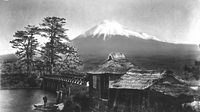
FUJIYAMA / 富士山 BY KUSAKABE KIMBEI / 日下部 金兵衛

KUSAKABE KIMBEI / 日下部 金兵衛  (1841-1934) Fujiyama / 富士山 (3, 776 m -12,389 ft)  Japan   In  Fujiyama from Kawaibashi at Tokaido, 1880, albumin print,  Lainger Library, Georgetown University collection

KUSAKABE KIMBEI / 日下部 金兵衛  (1841-1934)
Fujiyama / 富士山 (3, 776 m -12,389 ft)
 Japan 

In  Fujiyama from Kawaibashi at Tokaido, 1880, albumin print, 
Lainger Library, Georgetown University collection 

The mountain 
This is the legendary Mount Fuji or Fujiyama (富士山).
It is located on Honshu Island and is the highest mountain peak in Japan at 3,776.24 m (12,389 ft). Several names are attributed to it:  "Fuji-san", "Fujiyama" or, redundantly, "Mt. Fujiyama". Usually Japanese speakers refer to the mountain as "Fuji-san".  The other Japanese names for Mount Fuji,  have become obsolete or poetic like: Fuji-no-Yama (ふじの山 - The Mountain of Fuji), Fuji-no-Takane (ふじの高嶺- The High Peak of Fuji), Fuyō-hō (芙蓉峰 - The Lotus Peak), and Fugaku (富岳/富嶽), created by combining the first character of 富士, Fuji, and 岳, mountain.
Mount Fuji is an active stratovolcano that last erupted in 1707–08. Mount Fuji lies about 100 kilometres (60 mi) south-west of Tokyo, and can be seen from there on a clear day.
Mount Fuji's exceptionally symmetrical cone, which is snow-capped several months a year, is a well-known symbol of Japan and it is frequently depicted in art and photographs, as well as visited by sightseers and climbers.
Mount Fuji is one of Japan's Three Holy Mountains (三霊山) along with Mount Tate and Mount Haku. It is also a Special Place of Scenic Beauty and one of Japan's Historic Sites.
It was added to the World Heritage List as a Cultural Site on June 22, 2013. As per UNESCO, Mount Fuji has “inspired artists and poets and been the object of pilgrimage for centuries”. UNESCO recognizes 25 sites of cultural interest within the Mt. Fuji locality. These 25 locations include the mountain itself, Fujisan Hongū Sengen Shrine and six other Sengen shrines, two lodging houses, Lake Yamanaka, Lake Kawaguchi, the eight Oshino Hakkai hot springs, two lava tree molds, the remains of the Fuji-kō cult in the Hitoana cave, Shiraito Falls, and Miho no Matsubara pine tree grove; while on the low alps of Mount Fuji lies the Taisekiji temple complex, where the central base headquarters of Nichiren Shoshu Buddhism is located.

The artist 
Kusakabe Kimbei (日下部 金兵衛) (1841–1934) was a Japanese photographer. He usually went by his given name, Kimbei, because his clientele, mostly non-Japanese-speaking foreign residents and visitors, found it easier to pronounce than his family name.
Kusakabe Kimbei worked with Felice Beato and Baron Raimund von Stillfried as a photographic colourist and assistant. In 1881, Kimbei opened his own workshop in Yokohama, in the Benten-dōri quarter. From 1889, the studio operated in the Honmachi quarter.
By 1893, his was one of the leading Japanese studios supplying art to Western customers. Many of the photographs in the studio's catalogue featured depictions of Japanese women, which were popular with tourists of the time.  Kimbei preferred to portray female subjects in a traditional bijinga style, and hired geisha to pose for the photographs. Many of his albums are mounted in accordion fashion.
Around 1885, Kimbei acquired the negatives of Felice Beato and of Stillfried, as well as those of Uchida Kuichi. Kusakabe also acquired some of Ueno Hikoma's negatives of Nagasaki.
Kimbei retired as a photographer in 1914.
___________________________________________
2019 - Wandering Vertexes...
by Francis Rousseau 

Monday, April 15, 2019

OL-OLOKWE PAINTED BY PILLY TURNER


PILLY TURNER (active 1955-1970)
Ol- Olokwe (1,934m  - 6,345 ft) 
Kenya

In Mount 0l Olokwe, watercolour - N.F.P. Kenya Card,  East Africa Women's League

The mountain 
Ol- Olokwe (1,934m  - 6,345 ft)  meaning Sacred Mountain, is a flat topped mountain located in the NFD of Kenya, a few kilometres north of the Samburu National Park. Rising out of the northern rift valley it is one of the most striking natural features in Kenya and well worth the visit. "Ol- Olokwe, a huge, square-shaped mountain, beckoned us and, as we drew closer, its magnificence increased... The enormity of the cliff face was so awe inspiring, and the colors of the granite were a deep tan splashed with orange and streaked with black and white - the white being bird of prey droppings" 
The hiking takes about 3-5 hours with an option of camping on the top. In the nearby area there is the Samburu National Park, the Matthews range and the small town of Archers Post (last stop for supplies).

The artist
Pilly Turner is a kenyan watercolourist, active during the 1955-1970 's. The watercolor she painted are always very realistic, and  with exemples of wild life animals and animals of the country. There are no other information available about this artist and only a few amount of paintings on the art market  (more than 10).

___________________________________________
2019 - Wandering Vertexes...
by Francis Rousseau 

Sunday, April 14, 2019

TAOSHAN / 桃山 BY WU GUANZHONG / 吴冠中


WU GUANZHONG / 吴冠中 (1919- 2010) 
Taoshan / 桃山 or Tao Mountain ( 3,325m - 10,909 ft) 
Taïwan

In  New House in the Lao Mountains, 1975, Singapore Art Museum (SAM) 


The mountains
Taoshan /  桃山 or Tao Mountain ( 3,325m - 10,909 ft) is a  mountain located in the north of the Wuling Farm and is one of Snow Mountains group.in Taïwan. The mountain is ranked N° 44 in Taiwan hicking declination scale.  In Atayal language (local tribe) the mountain is known as "Babo Kaba", meaning "Fist Hill". In Chinese the name translates as "Peach" mountain, due to the view from southwest side.

There are several climbing paths towards Taoshan. The simplest is through the Wuling four show route, starting from Sancha camp. There is also another path that directly goes up to Tao Shan, which starts from Tao Shan waterfall park.

The painter 
Wu Guanzhong / 吴冠中  was a contemporary Chinese painter widely recognized as a founder of modern Chinese painting.  He is considered to be one of the greatest contemporary Chinese painters. Wu's artworks had both Western and Eastern influences, such as the Western style of Fauvism and the Eastern style of Chinese calligraphy. Wu had painted various aspects of China, including much of its architecture, plants, animals, people, as well as many of its landscapes and waterscapes in a style reminiscent of the impressionist painters of the early 1900s. He was also a writer on contemporary Chinese art. Most of Wu’s early works were destroyed during the Cultural Revolution. It is difficult to track down works from his early days. Wu had an exhibit in 1942 when he was in school and it was hosted by the Sha Ping Youth Palace.
Wu Guanzhong has had solo exhibitions in major art galleries and museums around the world, including China, Hong Kong, Singapore, Tokyo, Taipei, Korea, France, England and the USA. His paintings were exhibited at the British Museum in 199;, being the first living Chinese artist to have an exhibition there. One of his paintings, Seascape at Beidaihe (1977), was shown at the Metropolitan Museum of Art as part of an exhibition of paintings from the collection of art dealer Robert H. Ellsworth. His work may also be seen in the collection of the Hong Kong Museum of Art.
In 2008, Wu donated 113 works to the Singapore Art Museum (SAM). This donation is the largest Wu Guanzhong donation to a public museum.
In 2010, Wu donated works to the Hong Kong Art Museum.

___________________________________________
2019 - Wandering Vertexes...
by Francis Rousseau 

Saturday, April 13, 2019

THE ORTLER BY EDWARD T. COMPTON


EDWARD T. COMPTON (1849-1921)
Ortler (3,905 m -12,812 ft)
Italy (South Tyrol) 

In The Ortler South Tyrol, watercolour on paper,  26 x 37cm, John Mitchell Gallery 

The mountain 
The Ortler (3,905 m -12,812 ft) is the highest mountain in the Eastern Alps outside the Bernina Range. It is the main peak of the Ortler Range. It is the highest point of the Southern Limestone Alps, of the Italian province of South Tyrol, of Tyrol overall, and, until 1919, of the Austrian-Hungarian empire. In German the mountain is commonly referred to as "König Ortler" (King Ortler), like in the unofficial hymn of South Tyrol, the Bozner Bergsteigerlied.
The Ortler Alps were one of the main battlegrounds between Austrian and Italian troops in the First World War, being on the border of Italy and the Austrian Empire. The advantage of owning the highest point was very important. The Austrian troops had quickly occupied the highest peaks, and the Italian troops' main goal, for four years, was to dislodge them from the positions. In the mid-1990s, a mountain guide discovered two guns that had been stationed very near the top of the Ortler but had been hidden by snow ever since. The discovery was kept secret until the 200th anniversary of the first ascent in 2004. The cannons are now on display in a museum in Trafoi.

The painter 
Edward Theodore Compton, usually referred to as E. T. Compton, (1849 – 1921) was an English-born, German artist, illustrator and mountain climber, not to be confused with his son Edward Harrison Compton, also a mountain painter. He is well known for his paintings and drawings of alpine scenery, and as a mountaineer made 300 major ascents including no fewer than 27 first ascents.
Initially painting in the English romantic tradition, Compton later developed a more realistic representation of nature, being guided by his true artistic ideas while retaining topographical accuracy. Even his early watercolors show the great importance of brightness and light and his work is also remarkable for its portrayal of the elements such as water and air, including ascending mist and fog. He can be regarded as an impressionist.
He attended various art schools, including, for a time, the Royal Academy in London, but otherwise he was mainly self-taught in art.

___________________________________________
2019 - Wandering Vertexes...
by Francis Rousseau 

Friday, April 12, 2019

HALEMA'UMA'U BY CONSTANCE GORDON-CUMMING


CONSTANCE GORDON-CUMMING (1837–1924),
Halemaʻumaʻu  (1,076 m - 3,530 ft) 
United States of America (Hawai'i) 

In Halemaumau,1879, ink wash with white heightening over traces of graphite, 
 Honolulu Museum of art 


The volcano 
Halemaʻumaʻu Crater  ((1,076 m - 3,530 ft)   - six syllables pronounced HAH-lay-MAH-oo-MAH-oo-  is a pit crater located within the much larger summit caldera of Kīlauea in Hawaii Volcanoes National Park. The roughly circular crater was 770 meters (2,530 ft) x 900 m (2,950 ft) prior to collapses that roughly doubled the size of the crater after May 3, 2018.  Halemaʻumaʻu is home to Pele, goddess of fire and volcanoes, according to the traditions of Hawaiian religion. 
The crater until recently contained an active lava lake. From 2008, when the current vent inside Halemaʻumaʻu crater first erupted, to April 2015, lava was present inside the vent, fluctuating from 20 to 150 meters below the crater rim. On April 24, 2015 molten lava in the vent, known as the Overlook Crater, became directly visible for the first time from the Jaggar Museum overlook at the Hawaiian Volcano Observatory, when the lava rose to an all-time high level since the Overlook Crater first opened.  A few days later, on April 29, the lava started spilling over the rim of the Overlook Crater and onto the floor of Halemaʻumaʻu Crater,  ultimately adding a layer of lava approximately 30 feet (9 m) thick to the crater floor.
For three years from 2015 to 2018 the lava lake level remained close to the rim, with a further minor overflow event in October 2016 and a significant one in April 2018 that covered a majority of the crater floor in new lava.  In early May 2018 the lava level in the Overlook Crater dropped over 700 feet and out of sight, resulting in explosions, earthquakes and large clouds of ash and toxic gas, causing closure of the Kīlauea summit area of the national park from May 10 to September 22. While the park visitor center and headquarters have reopened to the public, the crater is currently in a state of collapse that includes substantial portions of Kīlauea Caldera. The Jaggar Museum overlooking the crater remains closed.

The painter 
Constance Frederica “Eka” Gordon-Cumming  was a noted Scottish travel writer and painter. Born in a wealthy family, she travelled around the world and painted described scenes and life as she saw them.
Constance Gordon-Cumming was a prolific landscape painter, mostly in Asia and the Pacific. She painted over a thousand watercolors and worked with a motto to ‘never a day without at least one careful-coloured sketch’ starting her day at 5 am while in India. Places she visited include Australia, New Zealand, America, China, and Japan. 
She arrived in Hilo, Hawaii in October 1879, and was among the first artists to paint the active volcanoes.  Her Hawaii travelogue, Fire Fountains: The Kingdom of Hawaii, was published in Edinburgh in 1883.  She had several dangerous moments but her travel ended in 1880 when the Montana that she was on ran into rocks at Holyhead. While most of the passengers took the lifeboat, she stayed on last along with the captain to save her paintings and was rescued many hours later. She returned to live at Crieff with her widowed sister Eleanor and continued to write books.
Her best known books are At Home in Fiji and A Lady's Cruise on a French Man-of-War. The latter book resulted from an invitation to join a French ship put into service for the Bishop of Samoa so that he could visit remote parts of his far-flung diocese.
Miss Gordon-Cumming received much criticism from male writers of the era, perhaps because she did not fit in the traditional Victorian role of women, as she often traveled alone and unaided. 
 In any case, her landscape drawings and watercolors seem to be universally admired.


___________________________________________
2019 - Wandering Vertexes...
by Francis Rousseau 

Thursday, April 11, 2019

PICO TURQUINO BY EDMUND DARCH LEWIS


EDMUND DARCH LEWIS (1835-1910) 
Pico Turquino  (1,974m- 6,476 ft) 
Cuba 

In Pico Turquino - View of Cuba, oil on canvas ( 30x47cm), 1860.

The mountain
Pico Turquino (literally "Turquoise Peak") is Cuba's highest point at 1,974 meters above sea level. Located in the center of the Sierra Maestra, it lies within the Turquino  National Park - also known as the Sierra Maestra National Park. Its summit has been the subject of a sort of pilgrimage since the father of the revolutionary fighter Celia Sánchez erected in 1953 a bust of the national hero José Martí.

The artist
Edmund Darch Lewis was an American landscape painter known for his prolific style, marine oils and watercolors. Lewis was born in Philadelphia, Pennsylvania, in a well-to-do family. He started training at age 15 with German-born Paul Weber (1823–1916) of the Hudson River School.
At age 19 he exhibited at the Pennsylvania Academy of the Fine Arts, and was elected an Associate of the Academy at age 24.
Lewis's early work in oil, because of his excellent training, was precocious and is considered technically superior to his later work. He traveled throughout Pennsylvania, New Jersey and New York, painting river scenes, and for two decades he traveled to the White Mountains and painted landscapes of mountains, rivers, and lakes. He made extensive marine paintings throughout New England, becoming a prolific and successful artist.  His work was appreciated because of the luminosity of their objects. Because of the lively yet glowing work, he is considered one of the Luminist painters in the Hudson River School.
After mastering oil painting early in his career, Lewis switched to watercolor painting. Although not as technically outstanding, his watercolors were also admired for their luminosity - Luminism, and Lewis continued to generate canvases in mass production style.
___________________________________________
2019 - Wandering Vertexes...
by Francis Rousseau 

Wednesday, April 10, 2019

SAKURAJIMA VOLCANO / 桜島 BY UTAGAWA HIROSHIGE / 歌川 広重


UTAGAWA HIROSHIGE  / 歌川 広重 (1797-1858)
Sakurajima volcano / 桜島 (1,117 m - 3,665 ft)
Japan (Kagoshima) 

About the painting
This work by the great artist Utagawa Hiroshige (歌川 広重) shows the volcano at the beginning of XIXe century, before its major 1914 eruption. Nowadays, the shape of the volcano and of the all area is quite different. 

The volcano
Sakurajima / 桜島 (1, 117 m - 3,665 ft)  which means "Cherry blossom Island" is an active composite volcano and a former island in Kagoshima Prefecture in Kyushu, Japan.  Sakurajima is a stratovolcano with  3 peaks :  Kita-dake (northern peak), Naka-dake (central peak) and Minami-dake (southern peak) which is active now. Kita-dake is Sakurajima's highest peak.
The mountain is located in a part of Kagoshima Bay known as Kinkō-wan. The former island is part of the city of Kagoshima. The surface of this volcanic peninsula is about 77 km2 (30 sq mi).
The lava flows of the 1914 eruption connected it with the Osumi Peninsula.
The volcanic activity still continues nowadays, dropping volcanic ash on the surroundings, making of this volcanoes one of the most active in the world with, at least,  a daily minor eruption.  Earlier eruptions built the white sands highlands in the region.  On September 13, 2016 a team of experts from Bristol University and the Sakurajima Volcano Research Centre in Japan suggested that the volcano could have a major eruption within 25 years.

The artist
Utagawa Hiroshige (歌川 広重), also know as Andō Hiroshige (安藤 広重), was a Japanese ukiyo-e artist, considered the last great master of that tradition. Hiroshige is best known for his landscapes, such as the series The Fifty-three Stations of the Tōkaidō (see above) and The Sixty-nine Stations of the Kiso Kaidō; and for his depictions of birds and flowers. The subjects of his work were atypical of the ukiyo-e genre, whose typical focus was on beautiful women, popular actors, and other scenes of the urban pleasure districts of Japan's Edo period (1603–1868). The popular Thirty-six Views of Mount Fuji series by Hokusai was a strong influence on Hiroshige's choice of subject, though Hiroshige's approach was more poetic and ambient than Hokusai's bolder, more formal prints.
Hiroshige produced over 8,000 works
He dominated landscape printmaking with his unique brand of intimate, almost small-scale works compared against the older traditions of landscape painting descended from Chinese landscape painters such as Sesshu. The travel prints generally depict travelers along famous routes experiencing the special attractions of various stops along the way. They travel in the rain, in snow, and during all of the seasons. In 1856, working with the publisher Uoya Eikichi, he created a series of luxury edition prints, made with the finest printing techniques including true gradation of color, the addition of mica to lend a unique iridescent effect, embossing, fabric printing, blind printing, and the use of glue printing (wherein ink is mixed with glue for a glittery effect).
For scholars and collectors, Hiroshige's death marked the beginning of a rapid decline in the ukiyo-e genre, especially in the face of the westernization that followed the Meiji Restoration of 1868.
Hiroshige's work came to have a marked influence on Western painting towards the close of the 19th century as a part of the trend in Japonism. Western artists closely studied Hiroshige's compositions, and some, such as Vincent van Gogh or Claude Monet, painted copies of Hiroshige's prints.
__________________________________________
2019 - Wandering Vertexes...
by Francis Rousseau 

Tuesday, April 9, 2019

KAILASH RANGE BY CONSTANCE GORDON-CUMMING


CONSTANCE GORDON-CUMMING (1837–1924)
Kailash  Range / Gangdisê Mountains (6,638 m - 21,778ft) 
China  (Tibet autonomous region) 

In The Khylas peaks and village of Pangi three miles above China on the sutledge, 1869- pencil, watercolor and bodycolor on paper 48.2 x 72.5 cm.

The mountain 
 The Kailash Range (Gangdisê Mountains), which forms part of the Transhimalaya in the Tibet Autonomous Region of China. It is the western subrange of the Transhimalaya System. The Nyenchen Tanglha is the eastern subrange.
The highest peak of the Gangdise Shan's peaks, Mount Kailash or Gang Rimpoché (6,638 m - 21,778ft) is a sacred place in four religions : Bön, Buddhism, Hinduism and Jainism.
For Böns, a religion native to Tibet,  it makes no doubt  that the entire mystical region and Kailash, which they call the "nine-story Swastika Mountain", is the axis mundi (Tagzig Olmo Lung Ring).
For Hindus, it is the home of the wild mountain god Shiva and a symbol of his penis.
For Jains it is where their first leader was enlightened.
For Buddhists, the navel of the universe; and for adherents of Bon, the abode of the sky goddess Sipaimen.

The painter 
Constance Frederica “Eka” Gordon-Cumming  was a noted Scottish travel writer and painter. Born in a wealthy family, she travelled around the world and painted described scenes and life as she saw them.
Constance Gordon-Cumming was a prolific landscape painter, mostly in Asia and the Pacific. She painted over a thousand watercolors and worked with a motto to ‘never a day without at least one careful-coloured sketch’ starting her day at 5 am while in India. Places she visited include Australia, New Zealand, America, China, and Japan. 
She arrived in Hilo, Hawaii in October 1879, and was among the first artists to paint the active volcanoes.  Her Hawaii travelogue, Fire Fountains: The Kingdom of Hawaii, was published in Edinburgh in 1883.  She had several dangerous moments but her travel ended in 1880 when the Montana that she was on ran into rocks at Holyhead. While most of the passengers took the lifeboat, she stayed on last along with the captain to save her paintings and was rescued many hours later. She returned to live at Crieff with her widowed sister Eleanor and continued to write books.
Her best known books are At Home in Fiji and A Lady's Cruise on a French Man-of-War. The latter book resulted from an invitation to join a French ship put into service for the Bishop of Samoa so that he could visit remote parts of his far-flung diocese.
Miss Gordon-Cumming received much criticism from male writers of the era, perhaps because she did not fit in the traditional Victorian role of women, as she often traveled alone and unaided. 
 In any case, her landscape drawings and watercolors seem to be universally admired.

___________________________________________
2019 - Wandering Vertexes...
by Francis Rousseau 


Monday, April 8, 2019

SINIOLCHU PHOTOGRAPHED IN 1899 BY VITTORIO SELLA


VITTORIO SELLA (1859-1943)
Siniolchu  (6,888 m -22,598 ft)
India (Sikkim) 

In Siniolchu  seen from  the Zemu  Glacier, silver gelatine print, 
396 x 297 mm, from an 18 x 24 plate), 1899. 
Fondazione Sella, Biella

The mountain 
Siniolchu  (6,888 m -22,598 ft) is one of the tallest mountains of the Indian state of Sikkim. Siniolchu is considered to be particularly aesthetically attractive, having been described by Douglas Freshfield as "the most superb triumph of mountain architecture and the most beautiful snow mountain in the world". It is situated near the green lake adjacent to Kangchenjunga, the highest peak in the state and third highest in the world. Siniolchu’s summit was first scaled in 1936 by the German climbers Karl Wien and Adi Gцttner.  Later Sikkimese Everest climber, Sonam Gyatso, also scaled the top.

The photographer

Vittorio Sella is a mountain italian climber and photographer who took his passion for mountains from his uncle, Quintino Sella, founder of the Italian Alpine Club.  He accomplished many remarkable climbs in the Alps, the first wintering in the Matterhorn and Mount Rose (1882) and the first winter crossing of Mont Blanc (1888).
He took part in various expeditions outside Italy:
- Three in the Caucasus in 1889, 1890 and 1896 where a summit still bears his name;
- The ascent of Mount Saint Elias in Alaska in 1897
- Sikkim and Nepal in 1899 (photo above)
- Possibly climb Mount Stanley in Uganda in 1906 during an expedition to the Rwenzori
- Recognition at K2  and Mustagh Tower in 1909
- In Morocco in 1925.
During expeditions in Alaska, Uganda and Karakoram (K2-Chogolisa), he accompanied the Duke of Abruzzi, Prince Luigi Amedeo di Savoia.
Full Wandering Vertexes entry  =>

___________________________________________
2019 - Wandering Vertexes...
by Francis Rousseau 

Sunday, April 7, 2019

RANGITOTO VOLCANO BY JOHN BARR CLARK HOYTE


JOHN BARR CLARK HOYTE (1835-1913), 
Rangitoto volcano   (260 m - 850 ft)
New Zealand (Rangitoto Island) 

 In Mount Ragitoto from St Georges' Bays Auckland, 1860, wash drawings,
 Alexander Turnbull Library 

The volcano
Rangitoto volcano   (260 m - 850 ft)  is a shield volcano  with a symetrical cone  situauted inthe center of  is a volcanic island in the Hauraki Gulf near Auckland, New Zealand. The 5.5 km wide island is an iconic and widely visible landmark of Auckland.  Rangitoto is the most recent and the largest (2311 hectares) of the approximately 50 volcanoes of the Auckland volcanic field.  It is separated from the mainland of Auckland's North Shore by the Rangitoto Channel. Since World War II, it has been linked by a causeway to the much older, non-volcanic Motutapu Island.
Rangitoto is Māori for  Bloody Sky, with the name coming from the full phrase Ngā Rangi-i-totongia-a Tama-te-kapua ("The days of the bleeding of Tama-te-kapua"). Tama-te-kapua was the captain of the Arawa waka (canoe) and was badly wounded on the island, after having lost a battle with the Tainui iwi (tribe) at Islington Bay.

The Painter 
John Barr Clark Hoyte was born in England, probably in London,  Nothing is known of Hoyte's education and artistic training and we are reduced to the obvious deduction that he was heir to the English tradition of topographic draughtsmanship and watercolour painting. Firm drawing underlies his landscapes, making it appropriate to group him with colonial surveyor–architect artists such as Edward Ashworth, Edmund Norman and George O'Brien.
During his years in New Zealand John Hoyte travelled assiduously in search of new scenes to exploit.   His pictorial exploration of the colony's principal dramatic landscapes was completed when he took a cruise circumnavigating the South Island in early 1877, exploring the coast of Fiordland with particular attention. New Zealand subjects would continue to inspire his production long after he had settled in Australia, where they shared his attention with coastal and mountain views drawn chiefly from the neighbourhood of Sydney.
Despite his apparent commercial success, however, Hoyte's standing, like that of George O'Brien, waned in the 1870s: a decade which marked a major shift in New Zealand colonial taste as the Turnerian Romantics such as Gully, J. C. Richmond and W. M. Hodgkins moved into greater prominence. They and their style were to dominate the following decades.

2019 - Wandering Vertexes...
by Francis Rousseau 

Saturday, April 6, 2019

GUNUNG SEMERU BY ERNEST DEZENTJE


ERNEST DEZENTJE (1885- 1972) 
Gunung Semeru  (3, 676m - 12, 060ft) 
Indonesia 

The mountain 
Mount Semeru - Gunung Semeru or Gunung Mahameru indonesian - (3, 676m - 12, 060ft)  is an active volcano located in East Java, Indonesia. It is the highest mountain on the island of Java. This stratovolcano is also known as Mahameru, meaning 'The Great Mountain. The name derived from the Hindu-Buddhist mythical mountain of Meru or Sumeru, the abode of gods.  Semeru is named from Sumeru, the central world-mountain in Buddhist cosmology and by extension Hinduism. As stated in legend, it was transplanted from India; the tale is recorded in the 15th-century East Javanese work Tantu Pagelaran. It was originally placed in the western part of the island, but that caused the island to tip, so it was moved eastward. On that journey, parts kept coming off the lower rim, forming the mountains Lawu, Wilis, Kelut, Kawi, Arjuno and Welirang. The damage thus caused to the foot of the mountain caused it to shake, and the top came off and created Penanggungan as well. Indonesian Hindus also hold a belief that the mountain is the abode of Shiva in Java.
Gunung Semeru or Mahameru is very steep rising abruptly above the coastal plains of eastern Java. Semeru lies at the south end of the Tengger Volcanic Complex.
Semeru's eruptive history is extensive.
Since 1818, at least 55 eruptions have been recorded (10 of which resulted in fatalities) consisting of both lava flows and pyroclastic flows. All historical eruptions have had a VEI of 2 or 3. Semeru has been in a state of near-constant eruption from 1967 to the present. At times, small eruptions happen every 20 minutes or so.
In 2014, there are as many as 25 non-native plants in Mount Semeru National Park, which threaten the endemic local plants. The foreign plants were imported by a Dutch botanist named Van Steenis, in the colonial era. They include Foeniculum vulgare mill, Verbena brasiliensis, chromolaena odorata, and Salvinia molesta.
Mud erosion from surrounding vegetable plantations are also making problem of silting of Ranu Pane Lake, which the lake becomes smaller and shallower. Research predicted the lake will disappear in about 2025, except the kind of vegetables plantation is replaced with more ecological plantations.
Semeru is regularly climbed by tourists, usually starting from the village of Ranu Pane to the north, but though non-technical it can be dangerous. mainly because of the  poisonous gases on Mount Semeru.

The painter
The ‘Indisch’- Indonesian landscape painter Ernest Regnard Leonce Dezentjé was an autodidact.  His career  (mostly local) began when first president of the Republic of Indonesia, Soekarno (1901-1970), - who declared the independence of the country in 1945, felt in love with his painting and decided to make him the  "court painter".  Dezentje was then labelled an impressionist of the early Indonesian School, being considered by critics and young artists as a  typical establishment artist.  Along his eminently nationalistic themas the mountains and volcanoes of Indonesia took a important place.

__________________________________________________
2019 - Wandering Vertexes...
by Francis Rousseau 

Friday, April 5, 2019

MOUNT WELLINGTON / KUNANYI BY WILLIAM CHARLES PIGUENIT


WILLIAM CHARLES PIGUENIT (1836-1914)
Mount Wellington - Kunanyi  (1, 269m - 4, 163ft)
Australia

In  Mount Wellington from Kangaroo Bay, oil on canvas, National Gallery of Australia  


The mountain 
Mount Wellington (1,269m - 4,163ft)  also known as Unghbanyahletta or Poorawetter or  Kunanyi in Aboriginal langage, is located in the southeast coastal region of Tasmania, Australia. The Palawa, the surviving descendants of the original indigenous Tasmanians, tend to prefer the latter name.  In 2013, a Tasmanian dual naming policy was announced and "Kunanyi - Mount Wellington" was named as one of the inaugural dual named geographic features.
The mountain is the summit of the Wellington Range on whose foothills is built much of the city of Hobart.  Mount Wellington is frequently covered by snow, sometimes even in summer, and the lower slopes are thickly forested, but criss-crossed by many walking tracks and a few fire trails. There is also a sealed narrow road to the summit, about 22 kilometres (14 mi) from Hobart central business district. An enclosed lookout near the summit provides spectacular views of the city below and to the east, the Derwent estuary, and also glimpses of the World Heritage Area nearly 100 kilometres (62 mi) west. From Hobart, the most distinctive feature of Mount Wellington is the cliff of dolerite columns known as the Organ Pipes.
The first recorded European in the area Abel Tasman probably did not see the mountain in 1642, as his ship was quite a distance out to sea as he sailed up the South East coast of the island - coming closer in near present-day North and Marion Bays. No other Europeans visited Tasmania until the late eighteenth century, when several visited southern Tasmania (then referred to as Van Diemens Land) including Frenchman Marion du Fresne (1772), Englishmen Tobias Furneaux (1773), James Cook (1777) and William Bligh (1788 and 1792), and Frenchman Bruni d'Entrecasteaux (1792–93).
In February 1836, Charles Darwin visited Hobart Town and climbed Mount Wellington. In his book "The Voyage of the Beagle", Darwin described the mountain thus;
"... In many parts the Eucalypti grew to a great size, and composed a noble forest. In some of the dampest ravines, tree-ferns flourished in an extraordinary manner; I saw one which must have been at least twenty feet high to the base of the fronds, and was in girth exactly six feet. The fronds forming the most elegant parasols, produced a gloomy shade, like that of the first hour of the night. The summit of the mountain is broad and flat, and is composed of huge angular masses of naked greenstone. Its elevation is 3,100 feet [940 m] above the level of the sea. The day was splendidly clear, and we enjoyed a most extensive view; to the north, the country appeared a mass of wooded mountains, of about the same height with that on which we were standing, and with an equally tame outline: to the south the broken land and water, forming many intricate bays, was mapped with clearness before us. ..."


The painter 
William Charles Piguenit also known as W.C. Piguenit or Bill Piguenit was an Australian landscape painter, amateur photographer, draughtsman and explorer, born in Hobart Town, Van Diemen’s Land. The family can be traced back to Pons, in the province of Saintonge, France, from which, as Huguenots, they escaped after the revocation of the Edict of Nantes in 1685 to settle in Bristol, Somerset. William Charles attended Cambridge House Academy in Hobart; a school report of 18 December 1849 praises his 'mapping, particularly that of Van Diemen’s Land’. In September 1850, as an assistant draughtsman, he joined the Tasmanian Lands and Survey Department where much of his time was spent preparing maps of Tasmania.
When Piguenit exhibited at Melbourne in 1870, showing a watercolour sketch of Mount Wellington from the Huon Road, the Daily Telegraph of 20 July called him 'a young artist who gives promise of better things’. His love for the Tasmanian landscape and his improved artistic ability led to his being invited to accompany James R. Scott’s expedition to Arthur Plains and Port Davey in March 1871 as official artist. The results of the trip formed the basis for later illustrations in the Picturesque Atlas of Australasia and in R.M. Johnston’s Systematic Account of the Geology of Tasmania.
Having won another silver medal from the academy in 1875 for Mount Olympus, Lake St Clair, Tasmania (see above), Piguenit sent five of his Grose Valley oil landscapes to the academy’s 1876 exhibition and was awarded a certificate of merit for one, though the Sydney Mail critic was tepid in his praise: 'It would be enough to say that they are all very nicely painted and that all have about the same colour and tone’.
Regarded as the leading Australian-born landscape painter in the latter part of the nineteenth century, Piguenit was a founding committee member of the Art Society of New South Wales (elected Vice President in 1886) and regularly showed work in its exhibitions. He was represented in many major exhibitions, such as the 1880 Melbourne International, and he received many awards, including silver medals in 1874 and 1875 from the NSW Academy of Art, two second prizes at the 1888 Melbourne Centennial International Exhibition and gold medals from the 1883 Calcutta International and the 1888 Queensland Art Society and Tasmanian Juvenile Industries exhibitions. He was hung in the Paris Salon in 1893 and at the Chicago World’s Fair in 1894 (Scene on the Upper Nepean River, now AGNSW). A Tasmanian view near Prince of Wales Bay was presented by the Government House Literary Society to their founder and patron, Lady Hamilton, on her departure in 1892.
_______________________________
2019 - Wandering Vertexes...
by Francis Rousseau 

Thursday, April 4, 2019

PILLON DU ROY BY JOSEPH GARIBALDI


JOSEPH GARIBALDI (1863-1941)  
Pilon du Roy (710m - 2,329ft) 
France ( Provence Alpes Cote d'Azur) 

The mountain 
The Pilon du Roy (710m - 2,329ft)  is the most famous summit of the Massif de l'Etoile situated in the south of  France, north of Marseilles. This rocky tooth placed on a ridge, visible from far away, is a little reminiscent of Pierra Menta Beaufortain ... A sports trail leads to his foot, but its summit is reserved for climbers. Nice view of Marseille, Garlaban and Sainte-Victoire.
The first traces of human occupation date from the late Neolithic period (3000 BC, Baou Roux). The Early Bronze Age (2000 BC) and the Late Bronze Age (800 BC) show peaks of occupation in the north, as for the Iron Age (500 BC). C. about), then around 200 BC. J.-C.
Around 123 BC BC, the Roman consul Gaius Sextius Calvinus, swept over the region with his legions and shaves the oppida.
The beginning of Christianity saw the occupation of the many sites (caves, hermitages) by hermits and monks. Only numerous oratories, hermitages and buildings that have lost their vocation (Notre-Dame des Anges) and a recently established monastery (Sainte Lioba) in Simiane remain.
Restanques in ruins under the pines testify of abandoned crops more recently.

The painter
The French painter from Marseille, Joseph Garibaldi is known for his peaceful visions of Provence in which he spent his entire life. Son of an Italian employee of the firm Noilly Prat in Marseille, the talent of Joseph Garibaldi is detected by Louis Prat, boss of the company, which makes him enroll in the School of Fine Arts of this city. The coming to Marseilles painter Lyon Antoine Vollon  is decisive: under his influence and his advice, he exhibited at the Salon. Garibaldi becomes his devoted friend, it is he who in August 1900 will assist him in his last days. He will be friends with Alexis Vollon, the son of Antoine, but also with his classmates and colleagues from the Association of Marseille Artists (AAM).
Joseph Garibaldi exhibited at the Salon des artistes from 1884 to 1914 where he obtained an honorable mention in 1887 and a medal of second class in 1897. These are mainly views of sites and famous monuments, ports of the coast: Cassis, where he paints regularly between 1884 and 1899, La Ciotat, where he is hosted by Antoine Lumière, Bandol, Sanary and Toulon. But his specialty will remain the Old Port of Marseille.
Until 1905 he benefited from the patronage of Baron Alphonse de Rothschild (1827-1905), who, guided by the critic Paul Leroy, was very supportive of Vollon's students, bought his paintings and donated them to provincial museums.
Apart from two incursions to Venice (1895 and 1903) and Corsica (1889 and 1895), or trips to Savoy (1904) and Ariège (1906), he is attached to his district of Rive-Neuve. It was only after the First World War that, benefiting from a lodging in Fos-sur-Mer, he went there regularly to paint.
In the 1930s, he was affected by glaucoma and stopped painting.

___________________________________________
2019 - Wandering Vertexes...
by Francis Rousseau 

Wednesday, April 3, 2019

ANSERIS MONS BY NASA MARS RECONNAISSANCE ORBITER


NASA MARS RECONNAISSANCE ORBITER (2005-2015)
Anseris Mons (6,200 m -20,300 ft)
MARS 

The mountain

Anseris Mons (6,200 m -20,300 ft) is an isolated massif of mountains in the southern highlands of Mars, located at the northeastern edge of Hellas Planitia at longitude 86.65°E and latitude 29.81°S. The mountain is 58 km (36 mi) in diameter and lies in the southeastern quarter of the Iapygia quadrangle (MC-21), straddling the boundary with the adjoining Hellas quadrangle (MC-28) to the south.,Anseris Mons is named from Anseris Fons, a telescopic albedo feature mapped by Greek astronomer E. M. Antoniadi in 1930. The name was approved by the International Astronomical Union (IAU) in 1991.
Anseris Mons is not a volcano. Geologically, the massif is thought to be the eroded remnant of an ancient crustal block uplifted from depths of several kilometers in the formation of the Hellas impact basin during the period of heavy bombardment. Anseris Mons is the type area for a large set of rugged mountain blocks (>25 km across) that occur in a relatively continuous band 200 to 500 km wide around the western, northeastern, eastern, and southeastern rim of the Hellas basin. Many of the blocks, particularly along the western rim, are concentric with the basin and bounded by faults.
Rocks making up Anseris Mons and other massifs around Hellas are mapped as Noachian in age. However, work by Herbert Frey at NASA’s Goddard Spaceflight Center using Mars Orbital Laser Altimeter (MOLA) data indicates that the southern highlands of Mars contain numerous buried impact basins that are older than the visible Noachian-aged surfaces and which pre-date the Hellas impact. He suggests that the Hellas impact should mark the beginning of the Noachian period (base of the Noachian system). If Frey is correct, then Anseris Mons bedrock is actually pre-Noachian in age, perhaps dating back to over 4.1 billion years ago.
The Anseris Mons massif has undergone a significant amount of erosion since it was uplifted. The flanks of the mountain have huge triangular re-entrants and associated spurs, which give the massif a broad, pyramidal shape. The re-entrants were likely produced through a variety of mass-wasting and periglacial/glacial processes. A large cirque-like re-entrant with channelized debris aprons or fans is present on the south side of the mountain.

Tuesday, April 2, 2019

MONTE BESSO PAINTED BY OTTO MÄLHY


OTTO MÄLHY (1869-1953) 
Monte Besso (3,667 m - 12, 034ft)
Switzerland

 In Monte Besso seen from Sorebois, Val d'Anniviers, Switzerland 
oil on canvas ( 88,5 x 72 cm) John  Mitchell Gallery, London 


The mountain 
Mount Besso (3,667 m - 12, 034ft) is a Swiss peak in the Pennine Alps valley. It is located on the edge of the Zinal valley.  The name Besso means 'twins' in the dialect of the Val d'Hérens and refers to the twin summits of the mountain.
The mountain is part of the so-called imperial crown , set of mountains that form a horseshoe: Les Diablons, the Bishorn (4,153 m), the Weisshorn (4,505 m), the Schalihorn (3,974 m), the Zinalrothorn (4,221 m), the Trifthorn (3,728 m), the Obergabelhorn (4,062 m), the Mont Durand (3,712 m), the Pointe de Zinal (3,790 m), the Dent Blanche (4,356 m), the Grand Cornier (3,961 m), the Pigne de la Lé (3.396 m), the Garde de Bordon (3.310 m), and at the center of this gigantic parable is Mount Besso (3.667 m).
The first ascent to the summit probably took place in 1862 by JB Epinay and J. Vianin. The normal ascent route to the summit starts from the Cabane du Grand Mountet. 

The painter 
 Otto Mähly was a Swiss artist who was born in 1869 in Basel. Otto Mähly's work has been offered at auction multiple times. Only one artwork sold; this was View of the Rigi, which realized $1,801 USD at Dobiaschofsky in 2017. The artist died in 1953.

___________________________________________
2019 - Wandering Vertexes...
by Francis Rousseau