google.com, pub-0288379932320714, DIRECT, f08c47fec0942fa0 GRAVIR LES MONTAGNES... EN PEINTURE: Search results for Chimborazo
Showing posts sorted by date for query Chimborazo. Sort by relevance Show all posts

Sunday, June 23, 2024

LES ANDES DU SUD  PEINTES PAR RHOD WULFARS

RHOD WULFARS (bn. 1979) Andes du sud (6,991 m - 22, 838ft) Argentine    In « Twin", acrylic on hardboard, 2018, Private collection


RHOD WULFARS (bn. 1979)
Andes du sud (6,991 m - 22, 838ft)
Argentine

In « Twin", acrylic on hardboard, 2018, Private collection 
@rhodwulfars

D'autres œuvres de cet artiste sur son site : rhodwulfars.wixsite.com/rhodwulfars/


L'artiste
Rhod Wulfars est un peintre de montagne contemporain utilisant principalement la technique acrylique pour ses peintures. Il est né en 1979 à Mendoza (Argentine). Sur son site Internet, il écrit : "J'ai passé toute ma vie près des montagnes. Un jour, j'ai commencé à les peindre". Utilisant, à la manière de Nicolas de Staël, un style toujours entre abstrait et figuratif, ses peintures très fortes et très émouvantes décrivent parfaitement la majesté et le contenu spectaculaire des sommets qu'il peint. Rhod Wulfars fait un usage surprenant du médium acrylique, en pâte épaisse comme on pourrait le faire avec de la peinture à l'huile. Il avait l'habitude de ne nommer ses œuvres que par des chiffres et des lettres de série, mais parfois il écrit le nom des sommets et le rend plus facile à identifier.

A propos des tableaux
Le peintre écrit : " Ce n'est pas une vraie montagne. La plupart de mes peintures naissent de la combinaison de l'imagination et des heures passées à les regarder, à les parcourir et à les sentir. Elles ressemblent à ces reliefs de la Cordillera andine argentine appelés "acarreos", qui sont de longues pentes de roche meuble très populaires et facilement visibles. très fréquemment observée. Ce tableau est donc celui d'une montagne inconnue, rêvée qui en résume plusieurs, et qui est sortie de mon inconscient un après-midi où le pinceau lui a donné vie de façon mystérieuse sans que je puisse l'expliquer. " Le plus étonnant étant qu'ils le font d'un seul coup de pinceau aussi puissant et définitif que le soulèvement rocheux lui-même qui a crée ses reliefs.

Les montagnes
Les Andes (Cordillera de los Andes en espagnol) sont la plus longue chaîne de montagnes continentales du monde, formant un plateau continu le long de la bordure ouest de l'Amérique du Sud. Leur étendue est de 7000 km (4350 mi) de long, 200 à 700 km (124 à 435 mi) de large (la plus large entre 18 ° S et 20 ° S de latitude) et d'une hauteur moyenne d'environ 4000 m (13123 pieds). Les Andes s'étendent du nord au sud à travers sept pays d'Amérique du Sud : le Venezuela, la Colombie, l'Équateur, le Pérou, la Bolivie, le Chili et l'Argentine.
La Cordillère des Andes est la plus haute chaîne de montagnes en dehors de l'Asie. La plus haute montagne en dehors de l'Asie, le mont Aconcagua en Argentine, s'élève à une altitude d'environ 6 961 m (22 838 pieds) au-dessus du niveau de la mer. Le pic du Chimborazo dans les Andes équatoriennes est plus éloigné du centre de la Terre que tout autre endroit à la surface de la Terre, en raison du renflement équatorial résultant de la rotation de la Terre. Les plus hauts volcans du monde se trouvent dans les Andes, y compris Ojos del Salado à la frontière Chili-Argentine, qui culmine à 6 893 m (22 615 pieds).
Les Andes font également partie de la Cordillère américaine, une chaîne de chaînes de montagnes (cordillère) qui consiste en une séquence presque continue de chaînes de montagnes qui forment la "colonne vertébrale" occidentale de l'Amérique du Nord, de l'Amérique centrale, de l'Amérique du Sud et de l'Antarctique.

_________________________________________

2023 - Wandering Vertexes ....
Errant au-dessus des Sommets Silencieux...
Un blog de Francis Rousseau


Monday, September 18, 2023

LES ANDES DU SUD   PEINTES PAR   RHOD WULFARS (bn. 1979)


RHOD WULFARS (bn. 1979) Andes du Sud (6, 991 m - 22, 838 ft) Argentine  In Andes from Menodza, 2018, acrylique sur radiographie, 24 x 30cm, Collection de l'artiste  @rhodwulfars D'autres œuvres de cet artiste sur son site : rhodwulfars.wixsite.com/rhodwulfars/


RHOD WULFARS (bn. 1979)
Andes du Sud (6, 991 m - 22, 838 ft)
Argentine

In Andes from Mendoza, 2018, acrylique sur radiographie, 24 x 30cm, Collection de l'artiste

@rhodwulfars
D'autres œuvres de cet artiste sur son site : rhodwulfars.wixsite.com/rhodwulfars/


L'artiste
Rhod Wulfars est un peintre de montagne contemporain utilisant principalement la technique acrylique pour ses peintures. Il est né en 1979 à Mendoza (Argentine). Sur son site Internet, il écrit : "J'ai passé toute ma vie près des montagnes. Un jour, j'ai commencé à les peindre". Utilisant, à la manière de Nicolas de Staël, un style toujours entre abstrait et figuratif, ses peintures très fortes et très émouvantes décrivent parfaitement la majesté et le contenu spectaculaire des sommets qu'il peint. Rhod Wulfars fait un usage surprenant du médium acrylique, en pâte épaisse comme on pourrait le faire avec de la peinture à l'huile. Il avait l'habitude de ne nommer ses œuvres que par des chiffres et des lettres de série, mais parfois il écrit le nom des sommets et le rend plus facile à identifier.

A propos des tableaux
Le peintre écrit : " Ce n'est pas une vraie montagne. La plupart de mes peintures naissent de la combinaison de l'imagination et des heures passées à les regarder, à les parcourir et à les sentir. Elles ressemblent à ces reliefs de la Cordillera andine argentine appelés "acarreos", qui sont de longues pentes de roche meuble très populaires et facilement visibles. très fréquemment observée. Ce tableau est donc celui d'une montagne inconnue, rêvée qui en résume plusieurs, et qui est sortie de mon inconscient un après-midi où le pinceau lui a donné vie de façon mystérieuse sans que je puisse l'expliquer. " Le plus étonnant étant qu'ils le font d'un seul coup de pinceau aussi puissant et définitif que le soulèvement rocheux lui-même qui a crée ses reliefs.

Les montagnes
Les Andes (Cordillera de los Andes en espagnol) sont la plus longue chaîne de montagnes continentales du monde, formant un plateau continu le long de la bordure ouest de l'Amérique du Sud. Leur étendue est de 7000 km (4350 mi) de long, 200 à 700 km (124 à 435 mi) de large (la plus large entre 18 ° S et 20 ° S de latitude) et d'une hauteur moyenne d'environ 4000 m (13123 pieds). Les Andes s'étendent du nord au sud à travers sept pays d'Amérique du Sud : le Venezuela, la Colombie, l'Équateur, le Pérou, la Bolivie, le Chili et l'Argentine.
La Cordillère des Andes est la plus haute chaîne de montagnes en dehors de l'Asie. La plus haute montagne en dehors de l'Asie, le mont Aconcagua en Argentine, s'élève à une altitude d'environ 6 961 m (22 838 pieds) au-dessus du niveau de la mer. Le pic du Chimborazo dans les Andes équatoriennes est plus éloigné du centre de la Terre que tout autre endroit à la surface de la Terre, en raison du renflement équatorial résultant de la rotation de la Terre. Les plus hauts volcans du monde se trouvent dans les Andes, y compris Ojos del Salado à la frontière Chili-Argentine, qui culmine à 6 893 m (22 615 pieds).
Les Andes font également partie de la Cordillère américaine, une chaîne de chaînes de montagnes (cordillère) qui consiste en une séquence presque continue de chaînes de montagnes qui forment la "colonne vertébrale" occidentale de l'Amérique du Nord, de l'Amérique centrale, de l'Amérique du Sud et de l'Antarctique.

_________________________________________

2023 - Wandering Vertexes ....
Errant au-dessus des Sommets Silencieux...
Un blog de Francis Rousseau

Tuesday, May 30, 2023

LES ANDES ARGENTINES PEINTES PAR RHOD WULFARS


RHOD WULFARS (né en 1979) Andes du Sud (6, 991 m - 22, 838 FT) Argentine  In Andes from Mendoza,  acrylique sur panneau dur, 2018, Collection de l'artiste @rhodwulfars D'autres œuvres de cet artiste sur son site : rhodwulfars.wixsite.com/rhodwulfars/

RHOD WULFARS (né en 1979)
Andes du Sud (6, 991 m - 22, 838 ft)
Argentine

In Andes from Menodza,  acrylique sur panneau dur, 2018, Collection de l'artiste @rhodwulfars
D'autres œuvres de cet artiste sur son site : rhodwulfars.wixsite.com/rhodwulfars/


L'artiste
Rhod Wulfars est un peintre de montagne contemporain utilisant principalement la technique acrylique pour ses peintures. Il est né en 1979 à Mendoza (Argentine). Sur son site Internet, il écrit : "J'ai passé toute ma vie près des montagnes. Un jour, j'ai commencé à les peindre". Utilisant, à la manière de Nicolas de Staël, un style toujours entre abstrait et figuratif, ses peintures très fortes et très émouvantes décrivent parfaitement la majesté et le contenu spectaculaire des sommets qu'il peint. Rhod Wulfars fait un usage surprenant du médium acrylique, en pâte épaisse comme on pourrait le faire avec de la peinture à l'huile. Il avait l'habitude de ne nommer ses œuvres que par des chiffres et des lettres de série, mais parfois il écrit le nom des sommets et le rend plus facile à identifier.

A propos des tableaux
Le peintre écrit : " Ce n'est pas une vraie montagne. La plupart de mes peintures naissent de la combinaison de l'imagination et des heures passées à les regarder, à les parcourir et à les sentir. Elles ressemblent à ces reliefs de la Coridilla andine argentine appelés "acarreos", qui sont de longues pentes de roche meuble très populaires et facilement visibles. très fréquemment observée. Ce tableau est donc celui d'une montagne inconnue, rêvée qui en résume plusieurs, et qui est sortie de mon inconscient un après-midi où le pinceau lui a donné vie de façon mystérieuse sans que je puisse l'expliquer. " Le plus étonnant étant qu'ils le font d'un seul coup de pinceau aussi puissant et définitif que le soulèvement rocheux lui-même qui a crée ses reliefs.

Les montagnes
Les Andes (Cordillera de los Andes en espagnol) sont la plus longue chaîne de montagnes continentales du monde, formant un plateau continu le long de la bordure ouest de l'Amérique du Sud. Leur étendue est de 7000 km (4350 mi) de long, 200 à 700 km (124 à 435 mi) de large (la plus large entre 18 ° S et 20 ° S de latitude) et d'une hauteur moyenne d'environ 4000 m (13123 pieds). Les Andes s'étendent du nord au sud à travers sept pays d'Amérique du Sud : le Venezuela, la Colombie, l'Équateur, le Pérou, la Bolivie, le Chili et l'Argentine.
La Cordillère des Andes est la plus haute chaîne de montagnes en dehors de l'Asie. La plus haute montagne en dehors de l'Asie, le mont Aconcagua en Argentine, s'élève à une altitude d'environ 6 961 m (22 838 pieds) au-dessus du niveau de la mer. Le pic du Chimborazo dans les Andes équatoriennes est plus éloigné du centre de la Terre que tout autre endroit à la surface de la Terre, en raison du renflement équatorial résultant de la rotation de la Terre. Les plus hauts volcans du monde se trouvent dans les Andes, y compris Ojos del Salado à la frontière Chili-Argentine, qui culmine à 6 893 m (22 615 pieds).
Les Andes font également partie de la Cordillère américaine, une chaîne de chaînes de montagnes (cordillère) qui consiste en une séquence presque continue de chaînes de montagnes qui forment la "colonne vertébrale" occidentale de l'Amérique du Nord, de l'Amérique centrale, de l'Amérique du Sud et de l'Antarctique.

_________________________________________

2023 - Wandering Vertexes ....
Errant au-dessus des Sommets Silencieux...
Un blog de Francis Rousseau

Monday, December 12, 2022

LES ANDES ARGENTINES PEINTES PAR RHOD WULFARS


RHOD WULFARS (né en 1979) Andes du Sud (6 991 m - 22 838 pieds) Argentine  In Andes, acrylique sur panneau dur, 2018, Collection de l'artiste @rhodwulfars D'autres oeuvres de cet artiste sur son site : rhodwulfars.wixsite.com/rhodwulfars/

RHOD WULFARS (né en 1979)
Andes du Sud (6 991 m - 22 838 pieds)
Argentine

In Andes, acrylique sur panneau dur, 2018, Collection de l'artiste @rhodwulfars
D'autres oeuvres de cet artiste sur son site : rhodwulfars.wixsite.com/rhodwulfars/


L'artiste
Rhod Wulfars est un peintre de montagne contemporain utilisant principalement la technique acrylique pour ses peintures. Il est né en 1979 à Mendoza (Argentine). Sur son site Internet, il écrit : "J'ai passé toute ma vie près des montagnes. Un jour, j'ai commencé à les peindre". Utilisant, à la manière de Nicolas de Staël, un style toujours entre abstrait et figuratif, ses peintures très fortes et très émouvantes décrivent parfaitement la majesté et le contenu spectaculaire des sommets qu'il peint. Rhod Wulfars fait un usage surprenant du médium acrylique, en pâte épaisse comme on pourrait le faire avec de la peinture à l'huile. Il avait l'habitude de ne nommer ses œuvres que par des chiffres et des lettres de série, mais parfois il écrit le nom des sommets et le rend plus facile à identifier. 

A propos des tableaux
Le peintre écrit : " Ce n'est pas une vraie montagne. La plupart de mes peintures naissent de la combinaison de l'imagination et des heures passées à les regarder, à les parcourir et à les sentir. Elles  ressemblent à ces reliefs de la Coridilla andine argentine appelés "acarreos", qui sont de longues pentes de roche meuble très populaires et facilement visibles. très fréquemment observée. Ce tableau est donc celui d'une montagne inconnue, rêvée qui en résume plusieurs, et qui est sortie de mon inconscient un après-midi où le pinceau lui a donné vie de façon mystérieuse sans que je puisse l'expliquer. "  Le plus étonnant étant qu'ils le font d'un seul coup de pinceau aussi puissant et définitif que le soulèvement rocheux lui-même qui a crée ses reliefs. 


Les montagnes
Les Andes (Cordillera de los Andes en espagnol) sont la plus longue chaîne de montagnes continentales du monde, formant un plateau continu le long de la bordure ouest de l'Amérique du Sud. Leur étendue est de  7000 km (4350 mi) de long, 200 à 700 km (124 à 435 mi) de large (la plus large entre 18 ° S et 20 ° S de latitude) et d'une hauteur moyenne d'environ 4000 m (13123 pieds). Les Andes s'étendent du nord au sud à travers sept pays d'Amérique du Sud : le Venezuela, la Colombie, l'Équateur, le Pérou, la Bolivie, le Chili et l'Argentine.
La Cordillère des Andes est la plus haute chaîne de montagnes en dehors de l'Asie. La plus haute montagne en dehors de l'Asie, le mont Aconcagua en Argentine, s'élève à une altitude d'environ 6 961 m (22 838 pieds) au-dessus du niveau de la mer. Le pic du Chimborazo dans les Andes équatoriennes est plus éloigné du centre de la Terre que tout autre endroit à la surface de la Terre, en raison du renflement équatorial résultant de la rotation de la Terre. Les plus hauts volcans du monde se trouvent dans les Andes, y compris Ojos del Salado à la frontière Chili-Argentine, qui culmine à 6 893 m (22 615 pieds).
Les Andes font également partie de la Cordillère américaine, une chaîne de chaînes de montagnes (cordillère) qui consiste en une séquence presque continue de chaînes de montagnes qui forment la "colonne vertébrale" occidentale de l'Amérique du Nord, de l'Amérique centrale, de l'Amérique du Sud et de l'Antarctique.

 _________________________________________

2022 - Wandering Vertexes ....
            Errant au-dessus des Sommets Silencieux...
            Un blog de Francis Rousseau

Wednesday, August 31, 2022

CHIMBORAZO PAINTED BY FREDERIC EDWIN CHURCH

FREDERIC EDWIN CHURCH (1826-1900) El Chimborazo (6,263 m -20,548 ft) Ecuador  In Mount Chimborazo Shown From Riobamba, Ecuador, 1857, Brush and oil on thin board, 29.1 x 44.1 cm (11 7/16 x 17 3/8 in.) Smithsonian/ Cooper Hewitt, Smithsonian Design Museum

FREDERIC EDWIN CHURCH (1826-1900)
El Chimborazo (6,263 m -20,548 ft)
Ecuador

In Mount Chimborazo Shown From Riobamba, Ecuador, 1857, Brush and oil on thin board,
29.1 x 44.1 cm (11 7/16 x 17 3/8 in.) Smithsonian/ Cooper Hewitt, Smithsonian Design Museum

 
The mountain
Chimborazo (6,263 m -20,548 ft) is a currently inactive stratovolcano in the Cordillera Occidental range of the Andes ans the highest mountain in Ecuador and the Andes north of Peru ; it is higher than any more northerly summit in the Americas. Chimborazo is not the highest mountain by elevation above sea level, but its location along the equatorial bulge makes its summit the farthest point on the Earth's surface from the Earth's center. Chimborazo is at the main end of the Ecuadorian Volcanic Arc, north west of the town of Riobamba. Chimborazo is in la Avenida de los Volcanes (the Avenue of Volcanoes) west of the Sanancajas mountain chain. Carihuairazo, Tungurahua, Tulabug, and El Altar are all mountains that neighbor Chimborazo. The closest mountain peak, Carihuairazo, is 5.8 mi (9.3 km) from Chimborazo. There are many microclimates near Chimborazo, varying from desert in the Arenal to the humid mountains in the Abraspungo valley. Its last known eruption is believed to have occurred around A.D. 550. Until the beginning of the 19th century, it was thought that Chimborazo was the highest mountain on Earth (measured from sea level), and such reputation led to many attempts on its summit during the 17th and 18th centuries. In 1746, the volcano was explored by French academicians from the French Geodesic Mission. Their mission was to determine the sphericity of the Earth. Their work along with another team in Lapland established that the Earth was an oblate spheroid rather than a true sphere. They did not reach the summit of Chimborazo. In 1802, during his expedition to South America, Baron Alexander von Humboldt, accompanied by Aimé Bonpland and the Ecuadorian Carlos Montufar, tried to reach the summit. From his description of the mountain, it seems that before he and his companions had to return suffering from altitude sickness they reached a point at 5,875 m, higher than previously attained by any European in recorded history. (Incans had reached much higher altitudes previously; see Llullaillaco). In 1831, Jean-Baptiste Boussingault and Colonel Hall reached a new "highest point", estimated to be 6,006 m. On 4 January 1880, the English climber Edward Whymper reached the summit of Chimborazo. The route that Whymper took up Chimborazo is now known as the Whymper route. Edward Whymper, and his Italian guides Louis Carrel and Jean-Antoine Carrel, were the first Europeans to summit a mountain higher than 20,000 feet. As there were many critics who doubted that Whymper had reached the summit, later in the same year he climbed to the summit again, choosing a different route (Pogyos) with the Ecuadorians David Beltrбn and Francisco Campaсa.


The painter
Frederic Edwin Church was an American landscape painter born in Hartford, Connecticut. He was a central figure in the Hudson River School of American landscape painters, perhaps best known for painting large panoramic landscapes, often depicting mountains, waterfalls, and sunsets, but also sometimes depicting dramatic natural phenomena that he saw during his travels to the Arctic and Central and South America. Church's paintings put an emphasis on light and a romantic respect for natural detail. In his later years, Church painted classical Mediterranean and Middle Eastern scenes and cityscapes. Church was the product of the second generation of the Hudson River School and the pupil of Thomas Cole, the school’s founder. The Hudson River School was established by the British Thomas Cole when he moved to America and started painting landscapes, mostly of mountains and other traditional American scenes. Both Cole and Church were devout Protestants and the latter's beliefs played a role in his paintings especially his early canvases. Church did differ from Cole in the topics of his paintings: he preferred natural and often majestic scenes over Cole's propensity towards allegory.
Church, like most second generation Hudson River School painters, used extraordinary detail, romanticism, and luminism in his paintings. Romanticism was prominent in Britain and France in the early 1800s as a counter-movement to the Enlightenment virtues of order and logic. Artists of the Romantic period often depicted nature in idealized scenes that depicted the richness and beauty of nature, sometimes also with emphasis on the grand scale of nature.
This tradition carries on in the works of Frederic Church, who idealizes an uninterrupted nature, highlighted by creating excruciatingly detailed art. The emphasis on nature is encouraged by the low horizontal lines, and preponderance of sky to enhance the wilderness; humanity, if it is represented, is depicted as small in comparison with the greater natural reality. The technical skill comes in the form of Luminism, a Hudson River School innovation particularly present in Church's works. Luminism is also cited as encompassing several technical aspects, which can be seen in Church’s works. One example is the attempt to “hide brushstrokes” which makes the scene seem more realistic and lessen the artist’s presence in the work. Most importantly is the emphasis on light (hence luminism) in these scenes. The several sources of light create contrast in the pictures that highlights the beauty and detailed imagery in the painting.
_________________________________________

2022 - Wandering Vertexes...
by Francis Rousseau


Thursday, June 30, 2022

PICO DEL TEIDE SKETCHED BY ALEXANDER VON HUMBOLDT


ALEXANDER VON HUMBOLDT (1769-1859), Pico del Teide (3, 718 m -12, 198 ft) Tenerife - Canari Islands - Spain   In  "Intérieur du Cratère du Pic de Teneriffe " Dessin, Alexander von Humboldt


ALEXANDER VON HUMBOLDT (1769-1859)
Pico del Teide (3, 718 m -12, 198 ft)
Tenerife - Canari Islands - Spain

 In  "Intérieur du Cratère du Pic de Teneriffe " Dessin, Alexander von Humboldt


The mountain
Pico del Teide (3,718m - 12,198 ft) (« Teide Peak") is a volcano on Tenerife in the Canary Islands, Spain. Before the 1495 Spanish colonization of Tenerife, the native Guanches called the volcano Echeyde, which in their legends referred to a powerful figure leaving the volcano, which could turn into hell. El Pico del Teide is the modern Spanish name.
Its summit is the highest point in Spain and the highest point above sea level in the islands of the Atlantic. If measured from its base on the ocean floor, it is at 7,500 m-24,600 ft the third highest volcano on a volcanic ocean island in the world after Mauna Kea and Mauna Loa in Hawaii. Its elevation makes Tenerife the tenth highest island in the world. It remains active: its most recent eruption occurred in 1909 from the El Chinyero vent on the northwestern Santiago rift.
Historical volcanic activity on the island is associated with vents on the Santiago or northwest rift (Boca Cangrejo in 1492, Montañas Negras in 1706, Narices del Teide or Chahorra in 1798 and El Chinyero in 1909) and the Cordillera Dorsal or northeast rift (Fasnia in 1704, Siete Fuentes and Arafo in 1705). The 1706 Montañas Negras eruption destroyed the town and principal port of Garachico, as well as several smaller villages.
In 1492, Christopher Columbus reported seeing "a great fire in the Orotava Valley" as he sailed past Tenerife on his voyage to discover the New World. This was interpreted as indicating that he had witnessed an eruption there. Radiometric dating of possible lavas indicates that in 1492 no eruption occurred in the Orotava Valley, but one did occur from the Boca Cangrejo vent.
The last summit eruption from Teide occurred about the year 850 CE, and this eruption produced the "Lavas Negras" that cover much of the flanks of the volcano.
About 150,000 years ago, a much larger explosive eruption occurred, probably of Volcanic Explosivity Index 5.
The United Nations Committee for Disaster Mitigation designated Teide a Decade Volcano because of its history of destructive eruptions and its proximity to several large towns, of which the closest are Garachico, Icod de los Vinos and Puerto de la Cruz. Teide, Pico Viejo and Montaсa Blanca form the Central Volcanic Complex of Tenerife.
In a publication of 1626, Sir Edmund Scory, who probably stayed on the island in the first decades of the 17th century, gives a description of Teide, in which he notes the suitable paths to the top and the effects the considerable height causes to the travellers, indicating that the volcano had been accessed via different routes before the 17th century. In 1715 the English traveler J. Edens and his party made the ascent and reported their observations in the journal of the Royal Society in London.
After the Enlightenment, most of the expeditions that went to East Africa and the Pacific had Teide as one of the most rewarding targets. The expedition of Lord George Macartney, George Staunton and John Barrow in 1792 almost ended in tragedy, as a major snowstorm and rain swept over them and they failed to reach the peak of Teide, just barely getting past Montaña Blanca.
During an expedition to Kilimanjaro, the German adventurer Hans Heinrich Joseph Meyer visited Teide in 1894 to observe ice conditions on the volcano. He described the two mountains as "two kings, one rising in the ocean and the other in the desert and steppes"
The volcano and its surroundings comprise Teide National Park, which has an area of 18,900 hectares (47,000 acres) and was named a World Heritage Site by UNESCO on June 28, 2007. Teide is the most visited natural wonder of Spain, the most visited national park in Spain and Europe and – by 2015 – the eighth most visited in the world, with some 3 million visitors yearly. A major international astronomical observatory is located on the slopes of the mountain.

The cartographer
Friedrich Wilhelm Heinrich Alexander von Humboldt was a Prussian geographer, naturalist, explorer, and influential proponent of Romantic philosophy and science. He was the younger brother of the Prussian minister, philosopher, and linguist Wilhelm von Humboldt (1767–1835). Humboldt's quantitative work on botanical geography laid the foundation for the field of biogeography. Humboldt's advocacy of long-term systematic geophysical measurement laid the foundation for modern geomagnetic and meteorological monitoring.
Between 1799 and 1804, Humboldt travelled extensively in Latin America, exploring and describing it for the first time from a modern scientific point of view. His description of the journey was written up and published in an enormous set of volumes over 21 years. Humboldt was one of the first people to propose that the lands bordering the Atlantic Ocean were once joined (South America and Africa in particular). Humboldt resurrected the use of the word cosmos from the ancient Greek and assigned it to his multi-volume treatise, Kosmos, in which he sought to unify diverse branches of scientific knowledge and culture. This important work also motivated a holistic perception of the universe as one interacting entity.
On their way back to Europe from Mexico on their way to the United States, Humboldt and his fellow scientist Aimé Bonpland stopped in Cuba for a While. After their first stay in Cuba of three months they returned the mainland at Cartagena de Indias (now in Colombia), a major center of trade in northern South America. Ascending the swollen stream of the Magdalena River to Honda and arrived in Bogotá on July 6, 1801 where they met Spanish botanist José Celestino Mutis, the head of the Royal Botanical Expedition to New Granada, staying there until September 8, 1801. Mutis was generous with his time and gave Humboldt access to the huge pictorial record he had compiled since 1783. Humboldt had hopes of connecting with the French sailing expedition of Baudin, now finally underway, so Bonpland and Humboldt hurried to Ecuador. They crossed the frozen ridges of the Cordillera Real, they reached Quito on 6 January 1802, after a tedious and difficult journey.
Their stay in Ecuador was marked by the ascent of Pichincha and their climb of Chimborazo, where Humboldt and his party reached an altitude of 19,286 feet (5,878 m). This was a world record at the time, but a thousand feet short of the summit. Humboldt's journey concluded with an expedition to the sources of the Amazon en route for Lima, Peru.
At Callao, the main port for Peru, Humboldt observed the transit of Mercury. On 9 November and studied the fertilizing properties of guano, rich in nitrogen, the subsequent introduction of which into Europe was due mainly to his writings.

___________________________________________
2022 - Wandering Vertexes...
by Francis Rousseau

Saturday, February 5, 2022

LOS FRAILES OR THE ORGANS OF ACTOPAN BY ALEXANDER VON HUMBOLDT


ALEXANDER VON HUMBOLDT (1769-1859) WILHELM FRIEDRICH ( 1760-1820), engraver The Organs of Actopan or Los Frailes (1,140 m - 3,740 ft) Mexico (Hidalgo) In Vues des Cordillères, et monumens des peuples indigènes de l'Amérique from the book  Voyage aux régions équinoxiales du nouveau continent, 1813

ALEXANDER VON HUMBOLDT (1769-1859)
WILHELM FRIEDRICH ( 1760-1820), engraver
The Organs of Actopan or Los Frailes (1,140 m - 3,740 ft)
Mexico (Hidalgo)

In Vues des Cordillères, et monumens des peuples indigènes de l'Amérique from the book  Voyage aux régions équinoxiales du nouveau continent, 1813


About this engraving and the mountain

On May 23 and 24, Humboldt would tour the Actopan Valley, and then leave on May 25 for Mexico City. During the visit, Humboldt drew and studied the Organs of Actopan, also known as Los Frailes,located 17 km southeast of Actopan in the municipality of El Arenal. Humboldt determines their height trigonometrically.In Actopan. The slender part of the rock is a hundred meters high; but the absolute elevation of the summit of the mountain, where the Organos begin to stand out, is 585 toises (1,140 m - 3,740 ft) .  It is on the way from Mexico to the mines of Guanaxuatotjuon distinguishes from very far away, and standing out on Thoiizon, the rock of Mamanchota: it rises in the middle of a forest of oaks, and oflers a very picturesque aspect. 

The artist and explorer
Friedrich Wilhelm Heinrich Alexander von Humboldt was a Prussian geographer, naturalist, explorer, and influential proponent of Romantic philosophy and science. He was the younger brother of the Prussian minister, philosopher, and linguist Wilhelm von Humboldt (1767–1835). Humboldt's quantitative work on botanical geography laid the foundation for the field of biogeography. Humboldt's advocacy of long-term systematic geophysical measurement laid the foundation for modern geomagnetic and meteorological monitoring.
Between 1799 and 1804, Humboldt travelled extensively in Latin America, exploring and describing it for the first time from a modern scientific point of view. His description of the journey was written up and published in an enormous set of volumes over 21 years. Humboldt was one of the first people to propose that the lands bordering the Atlantic Ocean were once joined (South America and Africa in particular). Humboldt resurrected the use of the word cosmos from the ancient Greek and assigned it to his multi-volume treatise, Kosmos, in which he sought to unify diverse branches of scientific knowledge and culture. This important work also motivated a holistic perception of the universe as one interacting entity.
On their way back to Europe from Mexico on their way to the United States, Humboldt and his fellow scientist Aimé Bonpland stopped in Cuba for a while. After their first stay in Cuba of three months they returned the mainland at Cartagena de Indias (now in Colombia), a major center of trade in northern South America. Ascending the swollen stream of the Magdalena River to Honda and arrived in Bogotá on July 6, 1801 where they met Spanish botanist José Celestino Mutis, the head of the Royal Botanical Expedition to New Granada, staying there until September 8, 1801. Mutis was generous with his time and gave Humboldt access to the huge pictorial record he had compiled since 1783. Humboldt had hopes of connecting with the French sailing expedition of Baudin, now finally underway, so Bonpland and Humboldt hurried to Ecuador. They crossed the frozen ridges of the Cordillera Real, they reached Quito on 6 January 1802, after a tedious and difficult journey.
Their stay in Ecuador was marked by the ascent of Pichincha and their climb of Chimborazo, where Humboldt and his party reached an altitude of 19,286 feet (5,878 m). This was a world record at the time, but a thousand feet short of the summit. Humboldt's journey concluded with an expedition to the sources of the Amazon en route for Lima, Peru.
At Callao, the main port for Peru, Humboldt observed the transit of Mercury. On 9 November and studied the fertilizing properties of guano, rich in nitrogen, the subsequent introduction of which into Europe was due mainly to his writings.
___________________________________________
2022 - Wandering Vertexes...
by Francis Rousseau


Sunday, January 23, 2022

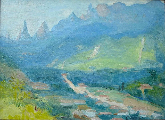
DEDO DE DEUS (2) PAINTED BY ELISEU VISCONTI

ELISEU VISCONTI (1866-1944) Dedo de Deus (1,682m - 5,551ft) Brazil


ELISEU VISCONTI (1866-1944)
Dedo de Deus (1,682m - 5,551ft)
Brazil


About this mainting
Eliseu Visconti painted a lot of times,the Dedo De Deus mountain in the Serra de Orgaos, in any season and in all possible light, at any time of day. It is THE  repetitive motif in his work, a bit like the Montagne Sainte-Victoire for Paul Cézanne or  the volcano Chimborazo for Frederic Edwin Church or Mount Everest for Nicholas Roerich.


The mountain
Dedo de Deus (The Finger of God) (1,682m - 5,551ft) is a peck whose outline resembles a hand pointing the index finger to the sky. It is one of the several geological monuments of Serra dos Órgãos which is located in Serra do Mar, between the cities of Petrópolis, Guapimirim and Teresópolis, in the state of Rio de Janeiro, in Brazil. The mountaineering in Brazil is closely linked to the achievement of the Dedo de deus. The peak is a state symbol Rio de Janeiro, appearing on its flag and coat of arms. As for the coat of arms of the State of Rio de Janeiro, the first section, occupying the upper half, is blue, representing the sky and symbolizing justice, truth and loyalty, with the silhouette of the Serra dos Órgãos, highlighting the Dedo de Deus. The symbol was created by the 1892 State Constitution and made official under the government of José Tomás da Porciúncula, with small differences over time. In 1912, José Guimarães Teixeira, Raul Carneiro and the brothers Américo, Alexandre and Acácio de Oliveira, all from Teresópolis, were the first to step on top of the rock formation.


The artist
Eliseu Visconti, born Eliseo d'Angelo Visconti was an Italian-born Brazilian painter, cartoonist, and teacher. He is considered one of the very few impressionist painters of Brazil. He is considered the initiator of the art nouveau in Brazil.
Thanks to a prize received in 1892, Visconti travelled to Paris, where he attended the École des Beaux Arts the following year. He also took classes at the Académie Julian and the École nationale supérieure des arts décoratifs, where he was a pupil of art nouveau master Eugène Grasset. He was accepted at the Salon de la Nationale des Beaux Arts and at the Salon of the Société of des Artistes Français. As one of the Brazilian representatives to the Exposition Universelle 1900 he exhibited the paintings Gioventú and Oréadas, for which he received a silver medal. Back in Brazil, Visconti exhibited in Rio de Janeiro and São Paulo, and obtained the first place in a contest for the drawing of postal stamps for the Brazilian Casa da Moeda. He traveled again to Europe, where he exhibited at the Paris Salon of 1905 the portrait of the artist Nicolina Vaz de Assis now at the Museu Nacional de Belas Artes. In this same year, he was invited to paint the stage curtain for the Teatro Municipal of Rio de Janeiro which he completed in his studio in Paris.
Decorative schemes executed for the National Library or Biblioteca Nacional in (Rio de Janeiro) date from this period as does another gold medal he received at the International Exhibition of Saint-Louis (Louisiana Purchase Exposition), in 1904, for the painting Recompensa de São Sebastião (see external links). The museum of Santiago of the Chile acquired his Sonho Místico (Mystical Dream) in 1912. In 1913, Visconti returned to Europe in order to paint large scale panels for the "foyer" of the Theatro Municipal do Rio de Janeiro. His plans to return were interrupted by the First World War so he stayed in France until 1920. The resulting paintings for the "foyer" were sent to Brazil during the war, in 1915. In 1922 his triptych "Lar" gained him the Medal of Honor in a large exhibition created in Rio de Janeiro to commemorate the first centennial of Brazilian Independence, the Exposição do Centenário. The following year Visconti painted the mural decoration of Rio de Janeiro's municipal council hall. In 1924, he painted the panel depicting the signature of the first Republican Constitution, for the old federal court, also in Rio de Janeiro.
_______________________________

2022 - Wandering Vertexes...
by Francis Rousseau

Monday, November 1, 2021

COFRE DE PEROTE / NAUPA-TECVUTÉPTL SKETCHED BY ALEXANDER VON HUMBOLDT


ALEXANDER VON HUMBOLDT  (1769-1859), Cofre de Perote/ Naupa-Tecutépetl (4,282 m (14,049 ft) Mexico


ALEXANDER VON HUMBOLDT (1769-1859),
Cofre de Perote/ Naupa-Tecutépetl (4,282 m (14,049 ft)
Mexico

 The mountain
Cofre de Perote, also known by its Nahuatl names Naupa-Tecutépetl ,  meaning something like "Place of Four Mountain" or "Mountain of the Lord of Four Places", is an inactive volcano located in the Mexican state of Veracruz, at the point where the Trans-Mexican Volcanic Belt, home to all of Mexico's highest peaks, joins the Sierra Madre Oriental. Cofre de Perote is Mexico's eighth highest mountain summit.
Cofre de Perote is a shield volcano, shaped very differently from the stratovolcanic Pico de Orizaba, which lies about 50 km (31 mi) to the southeast. A cofre is a coffer, and the name alludes to a volcanic outcropping on the shield which constitutes the peak of the mountain. To the north is the town of Perote, Veracruz, after which the mountain is named. The area surrounding the volcano was protected by the Mexican government as a national park, known as Cofre de Perote National Park (Parque Nacional Cofre de Perote), in 1937.

The artist
Friedrich Wilhelm Heinrich Alexander von Humboldt was a Prussian geographer, naturalist, explorer, and influential proponent of Romantic philosophy and science. He was the younger brother of the Prussian minister, philosopher, and linguist Wilhelm von Humboldt (1767–1835). Humboldt's quantitative work on botanical geography laid the foundation for the field of biogeography. Humboldt's advocacy of long-term systematic geophysical measurement laid the foundation for modern geomagnetic and meteorological monitoring.
Between 1799 and 1804, Humboldt travelled extensively in Latin America, exploring and describing it for the first time from a modern scientific point of view. His description of the journey was written up and published in an enormous set of volumes over 21 years. Humboldt was one of the first people to propose that the lands bordering the Atlantic Ocean were once joined (South America and Africa in particular). Humboldt resurrected the use of the word cosmos from the ancient Greek and assigned it to his multi-volume treatise, Kosmos, in which he sought to unify diverse branches of scientific knowledge and culture. This important work also motivated a holistic perception of the universe as one interacting entity.
On their way back to Europe from Mexico on their way to the United States, Humboldt and his fellow scientist Aimé Bonpland stopped in Cuba for a while. After their first stay in Cuba of three months they returned the mainland at Cartagena de Indias (now in Colombia), a major center of trade in northern South America. Ascending the swollen stream of the Magdalena River to Honda and arrived in Bogotá on July 6, 1801 where they met Spanish botanist José Celestino Mutis, the head of the Royal Botanical Expedition to New Granada, staying there until September 8, 1801. Mutis was generous with his time and gave Humboldt access to the huge pictorial record he had compiled since 1783. Humboldt had hopes of connecting with the French sailing expedition of Baudin, now finally underway, so Bonpland and Humboldt hurried to Ecuador. They crossed the frozen ridges of the Cordillera Real, they reached Quito on 6 January 1802, after a tedious and difficult journey.
Their stay in Ecuador was marked by the ascent of Pichincha and their climb of Chimborazo, where Humboldt and his party reached an altitude of 19,286 feet (5,878 m). This was a world record at the time, but a thousand feet short of the summit. Humboldt's journey concluded with an expedition to the sources of the Amazon en route for Lima, Peru.
At Callao, the main port for Peru, Humboldt observed the transit of Mercury. On 9 November and studied the fertilizing properties of guano, rich in nitrogen, the subsequent introduction of which into Europe was due mainly to his writings.
___________________________________________
2021 - Wandering Vertexes...
by Francis Rousseau

Saturday, October 30, 2021

SOUTHERN ANDES (2) PAINTED BY RHOD WULFARS


RHOD WULFARS (bn. 1979), Southern Andes (6,991 m - 22, 838ft) Argentina  In Somewhere in Andes , acrylic on hardboard, 2018, Private collection @rhodwulfars

 
RHOD WULFARS (bn. 1979)
Southern Andes (6,991 m - 22, 838ft)
Argentina

In Somewhere in Andes, acrylic on hardboard, 2018, Private collection @rhodwulfars


About this painting
The painter wrote: “It is not a real mountain. Most of my paintings are born from the combination of the imagination and the hours spent looking, walking and smelling them. I call them "Twins" because they are similar to those reliefs of the Argentinian Andean Coridilla called "acarreos", which are long slopes of very popular loose rock that can be easily viewed. very frequently observed. This painting is therefore that of an unknown mountain, dreamt up which sums up several, and which came out of my unconscious one afternoon when the brush gave it life in a mysterious way without my being able to explain it. "
And indeed this mountain that looks a lot like the Alpamayo in Peru is not the Alpamayo (even if it could be the most famous South West face to be published very soon in this blog) !), any more than it is not the Cerro Poincenot, the Fitz Roy, the Cerro Torre or the Aconcagua, the highest peak in the Andes. These Twins imagined, encompassed, summarized and illustrated all these mountains at the same time. The most amazing being that they do it with a single stroke of the brushes as powerful and definitive as the rocky uplift itself.

The artist
Rhod Wulfars is a contemporary mountain painter using mainly acrylic technique for his paintings.
He was born in 1979 in Mendoza (Argentina). In his website he wrote: "I have spent my whole life by the mountains. On day I started to paint them". Using, in the manner of Nicolas de Staël, a style always beetween abstract and figurative, his very strong and very moving paintings described perfectly the majesty and the spectacular contents of the peaks he paints. Rhod Wulfars makes a surprising use of acrylic medium, in thick paste as one could do with oil paint. He used to named his works only bu numbers, and series letters, but sometime he writes the name of the peaks ans makes it more easy to identify. Other works by this artist on his website : rhodwulfars.wixsite.com/rhodwulfars/

The mountains
The Andes, Andes Mountains or Andean Mountains (Cordillera de los Andes in Spanish ) are the longest continental mountain range in the world, forming a continuous highland along the western edge of South America. The range is 7,000 km (4,350 mi) long, 200 to 700 km (124 to 435 mi) wide (widest between 18°S - 20°S latitude), and has an average height of about 4,000 m (13,123 ft). The Andes extend from north to south through seven South American countries: Venezuela, Colombia, Ecuador, Peru, Bolivia, Chile, and Argentina.
The Andes Mountains are the highest mountain range outside Asia. The highest mountain outside Asia, Argentina's Mount Aconcagua, rises to an elevation of about 6,961 m (22,838 ft) above sea level. The peak of Chimborazo in the Ecuadorian Andes is farther from the Earth's center than any other location on the Earth's surface, due to the equatorial bulge resulting from the Earth's rotation. The world's highest volcanoes are in the Andes, including Ojos del Salado on the Chile-Argentina border, which rises to 6,893 m (22,615 ft).
The Andes are also part of the American Cordillera, a chain of mountain ranges (cordillera) that consists of an almost continuous sequence of mountain ranges that form the western "backbone" of North America, Central America, South America and Antarctica.

 ___________________________________________

2021 - Wandering Vertexes...
by Francis Rousseau

Sunday, October 24, 2021

ILLINIZAS VOLCANOES SKETCHED BY FREDERIC EDWIN CHURCH (1826-1900)

FREDERIC EDWIN CHURCH (1826-1900), Illiniza Sur  (5,248 m-17, 218ft) Illiniza Norte 5,126 m-16, 818ft) Ecuador   In Mount Iliniza, Ecuador, July 3, 1857,  Graphite, brush and white gouache on green paper, 31.1 x 43.2 cm, Smithsonian / Cooper Hewitt, Smithsonian Design Museum

FREDERIC EDWIN CHURCH (1826-1900),
Illiniza Sur  (5,248 m-17, 218ft)
Illiniza Norte 5,126 m-16, 818ft)
Ecuador

 In Mount Iliniza, Ecuador, July 3, 1857,  Graphite, brush and white gouache on green paper, 31.1 x 43.2 cm, Smithsonian / Cooper Hewitt, Smithsonian Design Museum 


The volcanoes
The Illinizas are a pair of volcanic mountains that are located to the south of Quito, Ecuador. They are located in the Illinizas Ecological Reserve (Reserva Ecológica Los Illinizas). These twin mountains are separated by a saddle that is about a kilometer long. The peaks are among the highest in Ecuador, with Illiniza Sur (5248 m-17, 218ft) standing slightly taller than Illiniza Norte 5126 m- 16, 818ft) its northern counterpart.
Most guidebooks (for example, Lonely Planet Ecuador, Ecuador: A Climbing Guide) spell the mountain with only one "l" as in Iliniza. The name Illinizas is derived from the Kunza words for "masculine hill."
Whilst Illiniza Sur (the southern peak) is a more difficult climb due to its glacial nature, Illiniza Norte requires little or no climbing expertise, and may be climbed as a trekking peak. A guide is still recommended, however, as the path becomes hard to navigate as it approaches the summit.
The Illinizas are excellent mountains for acclimatization to altitude, and are frequently used as a preparatory climb to higher peaks such as Cotopaxi, Chimborazo and Cayambe.
There is a rustic refuge located between the north and south peaks. It can be reached in one hour by car from El Chaupi, followed by a three-hour climb. The refuge has gas stoves, pots and pans and bunk beds. It is necessary to bring warm sleeping bags and food, but water is available to be boiled. The Englishman Edward Whymper tried and failed twice to make the first ascent of Iliniza Sur. It was climbed for the first time in 1880 by his two Italian guides Jean-Antoine Carrel and Louis Carrel. The first ascent of Iliniza Norte was made in 1912 by the Ecuadorians Nicolás Martínez and Alejandro Villavicencio.


The painter

Frederic Edwin Church was an American landscape painter born in Hartford, Connecticut. He was a central figure in the Hudson River School of American landscape painters, perhaps best known for painting large panoramic landscapes, often depicting mountains, waterfalls, and sunsets, but also sometimes depicting dramatic natural phenomena that he saw during his travels to the Arctic and Central and South America. Church's paintings put an emphasis on light and a romantic respect for natural detail. In his later years, Church painted classical Mediterranean and Middle Eastern scenes and cityscapes.
Church was the product of the second generation of the Hudson River School and the pupil of Thomas Cole, the school’s founder. The Hudson River School was established by the British Thomas Cole when he moved to America and started painting landscapes, mostly of mountains and other traditional American scenes. Both Cole and Church were devout Protestants and the latter's beliefs played a role in his paintings especially his early canvases. Church did differ from Cole in the topics of his paintings: he preferred natural and often majestic scenes over Cole's propensity towards allegory.
Church, like most second generation Hudson River School painters, used extraordinary detail, romanticism, and luminism in his paintings. Romanticism was prominent in Britain and France in the early 1800s as a counter-movement to the Enlightenment virtues of order and logic. Artists of the Romantic period often depicted nature in idealized scenes that depicted the richness and beauty of nature, sometimes also with emphasis on the grand scale of nature.
This tradition carries on in the works of Frederic Church, who idealizes an uninterrupted nature, highlighted by creating excruciatingly detailed art. The emphasis on nature is encouraged by the low horizontal lines, and preponderance of sky to enhance the wilderness; humanity, if it is represented, is depicted as small in comparison with the greater natural reality. The technical skill comes in the form of luminism, a Hudson River School innovation particularly present in Church's works. Luminism is also cited as encompassing several technical aspects, which can be seen in Church’s works. One example is the attempt to “hide brushstrokes,” which makes the scene seem more realistic and lessen the artist’s presence in the work. Most importantly is the emphasis on light (hence luminism) in these scenes. The several sources of light create contrast in the pictures that highlights the beauty and detailed imagery in the painting.

___________________________________________
2021 - Wandering Vertexes...
by Francis Rousseau


Saturday, August 14, 2021

SOUTHERN ANDES SUMMIT PAINTED BY RHOD WULFARS (bn 1979)

RHOD WULFARS (bn. 1979), Southern Andes (6,991 m - 22, 838ft), Argentina,  In "Twin", acrylic on hardboard, 2018, Private collection @rhodwulfars
 
 
RHOD WULFARS (bn. 1979)
Southern Andes (6,991 m - 22, 838ft)
Argentina

In Twin, acrylic on hardboard, 2018, Private collection @rhodwulfars


About this painting
The painter wrote: “It is not a real mountain. Most of my paintings are born from the combination of the imagination and the hours spent looking, walking and smelling them. I call them "Twins" because they are similar to those reliefs of the Argentinian Andean Coridilla called "acarreos", which are long slopes of very popular loose rock that can be easily viewed. very frequently observed. This painting is therefore that of an unknown mountain, dreamt up which sums up several, and which came out of my unconscious one afternoon when the brush gave it life in a mysterious way without my being able to explain it. "
And indeed this mountain that looks a lot like the Alpamayo in Peru is not the Alpamayo (even if it could  be the most famous South West face to be published very soon in this blog) !), any more than it is not the Cerro Poincenot, the Fitz Roy, the Cerro Torre or the Aconcagua, the highest peak in the Andes. These Twins imagined, encompassed, summarized and illustrated all these mountains at the same time. The most amazing being that they do it with a single stroke of the brushes as powerful and definitive as the rocky uplift itself.


The artist
Rhod Wulfars is a contemporary mountain painter using mainly acrylic technique for his paintings.
He was born in 1979 in Mendoza (Argentina). In his website he wrote: "I have spent my whole life by the mountains. On day I started to paint them". Using, in the manner of Nicolas de Staël, a style always beetween abstract and figurative, his very strong and very moving paintings described perfectly the majesty and the spectacular contents of the peaks he paints. Rhod Wulfars makes a surprising use of acrylic medium, in thick paste as one could do with oil paint. He used to named his works only bu numbers, and series letters, but sometime he writes the name of the peaks ans makes it more easy to identify. Other works by this artist on his website : rhodwulfars.wixsite.com/rhodwulfars/

The mountains
The Andes, Andes Mountains or Andean Mountains (Cordillera de los Andes in Spanish ) are the longest continental mountain range in the world, forming a continuous highland along the western edge of South America. The range is 7,000 km (4,350 mi) long, 200 to 700 km (124 to 435 mi) wide (widest between 18°S - 20°S latitude), and has an average height of about 4,000 m (13,123 ft). The Andes extend from north to south through seven South American countries: Venezuela, Colombia, Ecuador, Peru, Bolivia, Chile, and Argentina.
The Andes Mountains are the highest mountain range outside Asia. The highest mountain outside Asia, Argentina's Mount Aconcagua, rises to an elevation of about 6,961 m (22,838 ft) above sea level. The peak of Chimborazo in the Ecuadorian Andes is farther from the Earth's center than any other location on the Earth's surface, due to the equatorial bulge resulting from the Earth's rotation. The world's highest volcanoes are in the Andes, including Ojos del Salado on the Chile-Argentina border, which rises to 6,893 m (22,615 ft).
The Andes are also part of the American Cordillera, a chain of mountain ranges (cordillera) that consists of an almost continuous sequence of mountain ranges that form the western "backbone" of North America, Central America, South America and Antarctica.

___________________________________________

2021 - Wandering Vertexes...
by Francis Rousseau

Wednesday, July 21, 2021

EL CHIMBORAZO SKETCHED BY ALEXANDER VON HUMBOLDT


ALEXANDER VON HUMBOLDT (1769-1859) Chimborazo (6,263 m-20,549 ft) Ecuador  In,  El Chimborazo vu de la plaine de Tapia, 1810


ALEXANDER VON HUMBOLDT (1769-1859)
Chimborazo (6,263 m-20,549 ft)
Ecuador

In  El Chimborazo vu de la plaine de Tapia, 1810


The mountain
El Chimborazo (6,263 m -20,548 ft) is a currently inactive stratovolcano in the Cordillera Occidental range of the Andes ans the highest mountain in Ecuador and the Andes north of Peru ; it is higher than any more northerly summit in the Americas. Chimborazo is not the highest mountain by elevation above sea level, but its location along the equatorial bulge makes its summit the farthest point on the Earth's surface from the Earth's center.
Chimborazo is at the main end of the Ecuadorian Volcanic Arc, north west of the town of Riobamba. Chimborazo is in la Avenida de los Volcanes (the Avenue of Volcanoes) west of the Sanancajas mountain chain. Carihuairazo, Tungurahua, Tulabug, and El Altar are all mountains that neighbor Chimborazo. The closest mountain peak, Carihuairazo, is 5.8 mi (9.3 km) from Chimborazo. There are many microclimates near Chimborazo, varying from desert in the Arenal to the humid mountains in the Abraspungo valley.
Its last known eruption is believed to have occurred around A.D. 550.
Until the beginning of the 19th century, it was thought that Chimborazo was the highest mountain on Earth (measured from sea level), and such reputation led to many attempts on its summit during the 17th and 18th centuries.
In 1746, the volcano was explored by French academicians from the French Geodesic Mission. Their mission was to determine the sphericity of the Earth. Their work along with another team in Lapland established that the Earth was an oblate spheroid rather than a true sphere. They did not reach the summit of Chimborazo.
In 1802, during his expedition to South America, Baron Alexander von Humboldt, accompanied by Aimé Bonpland and the Ecuadorian Carlos Montufar, tried to reach the summit. From his description of the mountain, it seems that before he and his companions had to return suffering from altitude sickness they reached a point at 5,875 m, higher than previously attained by any European in recorded history. (Incans had reached much higher altitudes previously). In 1831, Jean-Baptiste Boussingault and Colonel Hall reached a new "highest point", estimated to be 6,006 m.
On 4 January 1880, the English climber Edward Whymper reached the summit of Chimborazo. The route that Whymper took up Chimborazo is now known as the Whymper route. Edward Whymper, and his Italian guides Louis Carrel and Jean-Antoine Carrel, were the first Europeans to summit a mountain higher than 20,000 feet. As there were many critics who doubted that Whymper had reached the summit, later in the same year he climbed to the summit again, choosing a different route (Pogyos) with the Ecuadorians David Beltrбn and Francisco Campaсa.


The cartographer and artist
Friedrich Wilhelm Heinrich Alexander von Humboldt was a Prussian geographer, naturalist, explorer, and influential proponent of Romantic philosophy and science. He was the younger brother of the Prussian minister, philosopher, and linguist Wilhelm von Humboldt (1767–1835). Humboldt's quantitative work on botanical geography laid the foundation for the field of biogeography. Humboldt's advocacy of long-term systematic geophysical measurement laid the foundation for modern geomagnetic and meteorological monitoring.
Between 1799 and 1804, Humboldt travelled extensively in Latin America, exploring and describing it for the first time from a modern scientific point of view. His description of the journey was written up and published in an enormous set of volumes over 21 years. Humboldt was one of the first people to propose that the lands bordering the Atlantic Ocean were once joined (South America and Africa in particular). Humboldt resurrected the use of the word cosmos from the ancient Greek and assigned it to his multi-volume treatise, Kosmos, in which he sought to unify diverse branches of scientific knowledge and culture. This important work also motivated a holistic perception of the universe as one interacting entity.
On their way back to Europe from Mexico on their way to the United States, Humboldt and his fellow scientist Aimé Bonpland stopped in Cuba for a While. After their first stay in Cuba of three months they returned the mainland at Cartagena de Indias (now in Colombia), a major center of trade in northern South America. Ascending the swollen stream of the Magdalena River to Honda and arrived in Bogotá on July 6, 1801 where they met Spanish botanist José Celestino Mutis, the head of the Royal Botanical Expedition to New Granada, staying there until September 8, 1801. Mutis was generous with his time and gave Humboldt access to the huge pictorial record he had compiled since 1783. Humboldt had hopes of connecting with the French sailing expedition of Baudin, now finally underway, so Bonpland and Humboldt hurried to Ecuador. They crossed the frozen ridges of the Cordillera Real, they reached Quito on 6 January 1802, after a tedious and difficult journey.
Their stay in Ecuador was marked by the ascent of Pichincha and their climb of Chimborazo, where Humboldt and his party reached an altitude of 19,286 feet (5,878 m). This was a world record at the time, but a thousand feet short of the summit. Humboldt's journey concluded with an expedition to the sources of the Amazon en route for Lima, Peru.
At Callao, the main port for Peru, Humboldt observed the transit of Mercury. On 9 November and studied the fertilizing properties of guano, rich in nitrogen, the subsequent introduction of which into Europe was due mainly to his writings.

___________________________________________ 


2021 - Wandering Vertexes...
by Francis Rousseau

Wednesday, June 16, 2021

EL JORULLO SKETCHED BY ALEXANDER VON HUMBOLDT


ALEXANDER VON HUMBOLDT (1769-1859) El Jorullo (1,329m- 4,360ft) Mexico   In Volcan de Jorullo,  Vue des Coridllères et monumens des peuples indigènes de l'Amérique, 1816, Paris chez F. Schoell.

 ALEXANDER VON HUMBOLDT (1769-1859)
El Jorullo (1,329m- 4,360ft)
Mexico

 In Volcan de Jorullo,  Vue des Coridllères et monumens des peuples indigènes de l'Amérique, 1816, Paris chez F. Schoell.


About this drawing
Alexander von Humboldt climbed El Jorullo during the Mexican portion of his scientific expedition to Spanish America. When he visited on 19 September 1803, its multiple cones were still smoldering and the air was extremely hot and filled with volcanic gases. He wrote a detailed description of the climb, noting that his face and those of his travel companions were burned. The volcano enriched the local soil and there was considerable vegetation. Humboldt sketched the volcano in the distance (see above), showing multiple smoking cones. Humboldt undertook the climb with his scientific travel partner Aimé Bonpland, as well as a local Basque settler Ramón Epelde, and two local indigenous servants, whose names have not been recorded. Humboldt noted their assistance on site. Humboldt also notes that he consulted a 1782 publication Rusticatio Mexicana, by Rafael Landívar, who calculated the height of the volcano and the temperature of the thermal waters.


The volcano
El Jorullo  (1,329m- 4,360ft) is a cinder cone volcano in Michoacán, central Mexico, on the southwest slope of the central plateau, 33 miles (53 kilometers) southeast of Uruapan in an area known as the Michoacán-Guanajuato volcanic field.  It is about 6 miles (10 km) east-northeast of La Huacana.  El Jorullo has four smaller cinder cones which have grown from its flanks.  El Jorullo's crater is about 1,300 by 1,640 feet (400 by 500 m) wide and 490 feet (150 m) deep.   El Jorullo is one of two known volcanoes to have developed in Mexico in recent history. The second, born about 183 years later, was named Parícutin after a nearby village that it eventually destroyed. Parícutin is about 50 miles (80 km) northwest of El Jorullo. El Jorullo was first erupted on 29 September 1759. Earthquakes occurred prior to this first day of eruption. Once the volcano started erupting, it continued for 15 years, eventually ending in 1774.
El Jorullo did not develop on a corn field like Parícutin did, but it did destroy what had been a rich agricultural area. It grew approximately 820 feet (250 meters) from the ground in the first six weeks. The eruptions from El Jorullo were primarily phreatic and phreatomagmatic. This 15 year eruption was the longest one El Jorullo has had, and was the longest cinder cone eruption known. Lava flows can still be seen to the north and west of the volcano.  Parícutin and El Jorullo both rose in an area known for its volcanoes. Called the Trans-Mexican Volcanic Belt, the region stretches about 700 miles (1,120 km) from east to west across southern Mexico. The eruptive activity deposited a layer of volcanic rock some 6,000 feet thick, creating a high and fertile plateau. During summer months, the heights snag moisture-laden breezes from the Pacific Ocean; rich farmland, in turn, has made this belt the most populous region in Mexico. Though the region already boasted three of the country's four largest cities: Mexico City, Puebla, and Guadalajara (the area around Parícutin, some 200 miles west of the capital), it was still a peaceful backwater inhabited by Purépecha in the early 1940s. The crater and lake can now be reached by car.


The artist
Friedrich Wilhelm Heinrich Alexander von Humboldt was a Prussian geographer, naturalist, explorer, and influential proponent of Romantic philosophy and science. He was the younger brother of the Prussian minister, philosopher, and linguist Wilhelm von Humboldt (1767–1835). Humboldt's quantitative work on botanical geography laid the foundation for the field of biogeography. Humboldt's advocacy of long-term systematic geophysical measurement laid the foundation for modern geomagnetic and meteorological monitoring.
Between 1799 and 1804, Humboldt travelled extensively in Latin America, exploring and describing it for the first time from a modern scientific point of view. His description of the journey was written up and published in an enormous set of volumes over 21 years. Humboldt was one of the first people to propose that the lands bordering the Atlantic Ocean were once joined (South America and Africa in particular). Humboldt resurrected the use of the word cosmos from the ancient Greek and assigned it to his multi-volume treatise, Kosmos, in which he sought to unify diverse branches of scientific knowledge and culture. This important work also motivated a holistic perception of the universe as one interacting entity.
On their way back to Europe from Mexico on their way to the United States, Humboldt and his fellow scientist Aimé Bonpland stopped in Cuba for a while. After their first stay in Cuba of three months they returned the mainland at Cartagena de Indias (now in Colombia), a major center of trade in northern South America. Ascending the swollen stream of the Magdalena River to Honda and arrived in Bogotá on July 6, 1801 where they met Spanish botanist José Celestino Mutis, the head of the Royal Botanical Expedition to New Granada, staying there until September 8, 1801. Mutis was generous with his time and gave Humboldt access to the huge pictorial record he had compiled since 1783. Humboldt had hopes of connecting with the French sailing expedition of Baudin, now finally underway, so Bonpland and Humboldt hurried to Ecuador. They crossed the frozen ridges of the Cordillera Real, they reached Quito on 6 January 1802, after a tedious and difficult journey.
Their stay in Ecuador was marked by the ascent of Pichincha and their climb of Chimborazo, where Humboldt and his party reached an altitude of 19,286 feet (5,878 m). This was a world record at the time, but a thousand feet short of the summit. Humboldt's journey concluded with an expedition to the sources of the Amazon en route for Lima, Peru.
At Callao, the main port for Peru, Humboldt observed the transit of Mercury. On 9 November and studied the fertilizing properties of guano, rich in nitrogen, the subsequent introduction of which into Europe was due mainly to his writings.

___________________________________________ 


2021 - Wandering Vertexes and Mountain paintings 
by Francis Rousseau

Saturday, December 28, 2019

EL CHIMBORAZO & EL CARGUAIRAZO BY ALEXANDER VON HUMBOLDT


ALEXANDER VON HUMBOLDT (1769-1859
El Chimborazo (6,263 m -20,548 ft)  
Ecuador

1. Coloured aquatint by F. Arnold after J. Gmelin after Alexander von Humboldt.
2. Original print in Vista del Chimborazo y del Carguairazo from the book Vistas de las cordilleras y monumentos de los pueblos indígenas de América by Alexander von Himboldt and Aimé Bonpland, 1816

The mountain
El Chimborazo  (6,263 m -20,548 ft) is a currently inactive stratovolcano in the Cordillera Occidental range of the Andes ans the highest mountain in Ecuador and the Andes north of Peru ; it is higher than any more northerly summit in the Americas. Chimborazo is not the highest mountain by elevation above sea level, but its location along the equatorial bulge makes its summit the farthest point on the Earth's surface from the Earth's center.
Chimborazo is at the main end of the Ecuadorian Volcanic Arc, north west of the town of Riobamba. Chimborazo is in la Avenida de los Volcanes (the Avenue of Volcanoes) west of the Sanancajas mountain chain. Carihuairazo, Tungurahua, Tulabug, and El Altar are all mountains that neighbor Chimborazo.  The closest mountain peak, Carihuairazo, is 5.8 mi (9.3 km) from Chimborazo. There are many microclimates near Chimborazo, varying from desert in the Arenal to the humid mountains in the Abraspungo valley.
Its last known eruption is believed to have occurred around A.D. 550.
Until the beginning of the 19th century, it was thought that Chimborazo was the highest mountain on Earth (measured from sea level), and such reputation led to many attempts on its summit during the 17th and 18th centuries.
In 1746, the volcano was explored by French academicians from the  French Geodesic Mission. Their mission was to determine the sphericity of the Earth. Their work along with another team in Lapland established that the Earth was an oblate spheroid rather than a true sphere. They did not reach the summit of Chimborazo.
In 1802, during his expedition to South America, Baron Alexander von Humboldt, accompanied by Aimé Bonpland and the Ecuadorian Carlos Montufar, tried to reach the summit. From his description of the mountain, it seems that before he and his companions had to return suffering from altitude sickness they reached a point at 5,875 m, higher than previously attained by any European in recorded history. (Incans had reached much higher altitudes previously; see Llullaillaco). In 1831, Jean-Baptiste Boussingault and Colonel Hall reached a new "highest point", estimated to be 6,006 m.
El Carguairazo is an ancient collapsed volcano (to the right of Chimborazo on the engraving). The muddy flood which, in 1698, covered 18 square leagues of land, was not the result of an eruption proper. When the Carguairazo collapsed, the waters that it concealed in its breast rushed into the plain with impetuosity, and caused the disasters of which the historians of America speak.

The cartographer
Friedrich Wilhelm Heinrich Alexander von Humboldt was a Prussian geographer, naturalist, explorer, and influential proponent of Romantic philosophy and science. He was the younger brother of the Prussian minister, philosopher, and linguist Wilhelm von Humboldt (1767–1835). Humboldt's quantitative work on botanical geography laid the foundation for the field of biogeography. Humboldt's advocacy of long-term systematic geophysical measurement laid the foundation for modern geomagnetic and meteorological monitoring.
Between 1799 and 1804, Humboldt travelled extensively in Latin America, exploring and describing it for the first time from a modern scientific point of view. His description of the journey was written up and published in an enormous set of volumes over 21 years. Humboldt was one of the first people to propose that the lands bordering the Atlantic Ocean were once joined (South America and Africa in particular). Humboldt resurrected the use of the word cosmos from the ancient Greek and assigned it to his multi-volume treatise, Kosmos, in which he sought to unify diverse branches of scientific knowledge and culture. This important work also motivated a holistic perception of the universe as one interacting entity.
On their way back to Europe from Mexico on their way to the United States, Humboldt and his fellow scientist Aimé Bonpland stopped in Cuba for a While. After their first stay in Cuba of three months they returned the mainland at Cartagena de Indias (now in Colombia), a major center of trade in northern South America. Ascending the swollen stream of the Magdalena River to Honda and arrived in Bogotá on July 6, 1801 where they met Spanish botanist José Celestino Mutis, the head of the Royal Botanical Expedition to New Granada, staying there until September 8, 1801. Mutis was generous with his time and gave Humboldt access to the huge pictorial record he had compiled since 1783. Humboldt had hopes of connecting with the French sailing expedition of Baudin, now finally underway, so Bonpland and Humboldt hurried to Ecuador. They crossed the frozen ridges of the Cordillera Real, they reached Quito on 6 January 1802, after a tedious and difficult journey.
Their stay in Ecuador was marked by the ascent of Pichincha and their climb of Chimborazo, where Humboldt and his party reached an altitude of 19,286 feet (5,878 m). This was a world record at the time, but a thousand feet short of the summit. Humboldt's journey concluded with an expedition to the sources of the Amazon en route for Lima, Peru.
At Callao, the main port for Peru, Humboldt observed the transit of Mercury. On 9 November and studied the fertilizing properties of guano, rich in nitrogen, the subsequent introduction of which into Europe was due mainly to his writings.
___________________________________________
2019 - Wandering Vertexes...
by Francis Rousseau

Wednesday, December 4, 2019

EL CHIMBORAZO (2) PAINTED BY LUIS A. MARTINEZ


LUIS ALFREDO MARTINEZ (1869-1909) 
El Chimborazo (6,263 m -20,548 ft) 
Ecuador 

 In Entrada al Oriente, Chimborazo  - Museo del Banco Central, Cuenca, Ecuador


The mountain
Chimborazo (6,263 m -20,548 ft) is a currently inactive stratovolcano in the Cordillera Occidental range of the Andes ans the highest mountain in Ecuador and the Andes north of Peru ; it is higher than any more northerly summit in the Americas. Chimborazo is not the highest mountain by elevation above sea level, but its location along the equatorial bulge makes its summit the farthest point on the Earth's surface from the Earth's center.
Chimborazo is at the main end of the Ecuadorian Volcanic Arc, north west of the town of Riobamba. Chimborazo is in la Avenida de los Volcanes (the Avenue of Volcanoes) west of the Sanancajas mountain chain. Carihuairazo, Tungurahua, Tulabug, and El Altar are all mountains that neighbor Chimborazo. The closest mountain peak, Carihuairazo, is 5.8 mi (9.3 km) from Chimborazo. There are many microclimates near Chimborazo, varying from desert in the Arenal to the humid mountains in the Abraspungo valley.
Its last known eruption is believed to have occurred around A.D. 550.
Until the beginning of the 19th century, it was thought that Chimborazo was the highest mountain on Earth (measured from sea level), and such reputation led to many attempts on its summit during the 17th and 18th centuries.
In 1746, the volcano was explored by French academicians from the French Geodesic Mission. Their mission was to determine the sphericity of the Earth. Their work along with another team in Lapland established that the Earth was an oblate spheroid rather than a true sphere. They did not reach the summit of Chimborazo.
In 1802, during his expedition to South America, Baron Alexander von Humboldt, accompanied by Aimé Bonpland and the Ecuadorian Carlos Montufar, tried to reach the summit. From his description of the mountain, it seems that before he and his companions had to return suffering from altitude sickness they reached a point at 5,875 m, higher than previously attained by any European in recorded history. (Incans had reached much higher altitudes previously; see Llullaillaco). In 1831, Jean-Baptiste Boussingault and Colonel Hall reached a new "highest point", estimated to be 6,006 m.
On 4 January 1880, the English climber Edward Whymper reached the summit of Chimborazo. The route that Whymper took up Chimborazo is now known as the Whymper route. Edward Whymper, and his Italian guides Louis Carrel and Jean-Antoine Carrel, were the first Europeans to summit a mountain higher than 20,000 feet. As there were many critics who doubted that Whymper had reached the summit, later in the same year he climbed to the summit again, choosing a different route (Pogyos) with the Ecuadorians David Beltrбn and Francisco Campaсa.

The painter
Luis Alfredo Martínez Holguín was an Ecuadorian writer, painter and politician, with a marked liberal tendency and a friend of President Eloy Alfaro. Among the public positions he held are deputy to the National Congress for the province of Tungurahua, governor of the same province and undersecretary of the Ministry of Public Instruction. In the literary field, he is considered the initiator of realism in the country. In painting he was one of the few romanticist painters and the first costumbristas who enriched the arts during the first republican decades.
Luis Alfredo Martínez was attracted throughout his life to landscaping. In the prologue of one of his books he wrote: "I do not belong to any school, I am profoundly realistic, and I paint nature as it is and not as conventions teach."
Many of his paintings are outside the country: two of them in the Library of Congress of the United States , two in the Vatican Museum and one in Rio de Janeiro.
Since 1980, the Department of Culture of the Municipality of Ambato holds a painting contest named after Luis Alfredo Martínez, the "Luis A. Martínez Painting Salon".
___________________________________________
2019 - Wandering Vertexes...
by Francis Rousseau