google.com, pub-0288379932320714, DIRECT, f08c47fec0942fa0 GRAVIR LES MONTAGNES... EN PEINTURE: HILLS & RIDGES
Showing posts with label HILLS & RIDGES. Show all posts

Wednesday, April 20, 2022

LE ROCHER DES DEUX TROUS PAINTED BY VINCENT VAN GOGH


VINCENT VAN GOGH (1853-1890) Le Rocher des Deux Trous (348m - France (Provence)


VINCENT VAN GOGH (1853-1890)
Le Rocher des Deux Trous (348m - 1,141 ft)
France (Provence)


The hill
The Rocher des Deux Trous (348m) in the Alpilles massif is one of the most popular hikes for walkers, satrting from Saint-Remy de Provence. It offers a 360° panorama over the two slopes of the Alpilles and over the entire surrounding region, from Mont Ventoux to the north and as far as the Mediterranean Sea to the south, on a clear day. This picturesque rock eroded and sculpted by the North wind (the Mistral) was painted by Van Gogh during his stay in Saint-Paul de Mausole from May 1889 to May 1890.

The painter
Vincent Willem van Gogh was a Dutch Post-Impressionist painter who is among the most famous and influential figures in the history of Western art. In just over a decade he created about 2100 artworks, including around 860 oil paintings, most of them in the last two years of his life. They include landscapes, still lifes, portraits and self-portraits, and are characterized by bold, symbolic colours, and dramatic, impulsive and expressive brushwork that contributed to the foundations of modern art. He died by suicide at 37, following years of mental illness and poverty.
Born into an upper-middle-class family, Van Gogh drew as a child and was serious, quiet and thoughtful. As a young man he worked as an art dealer, often travelling, but became depressed after he was transferred to London. He turned to religion, and spent time as a missionary in southern Belgium. Later he drifted in ill health and solitude. He took up painting in 1881 having moved back home with his parents. His younger brother Theo supported him financially, and the two kept up a long correspondence by letter.
More about Vincent Van Gogh

_______________________________

2022 - Wandering Vertexes...
by Francis Rousseau

Sunday, April 3, 2022

THE CAP D'ANTIBES PAINTED BY NICOLAS DE STAËL


NICOLAS DE STAËL (1914-1955) Cap d'Antibes (19 m - 62,3 ft) France (Var)  In  Marine au cap d'Antibes, 1954 oil on canvas, 88.3 x 129.5 cm, Private collection.

NICOLAS DE STAËL (1914-1955)
Cap d'Antibes (19 m - 62,3 ft)
France (Alpes Maritimes)

In  Marine au cap d'Antibes, 1954 oil on canvas, 88.3 x 129.5 cm, Private collection.


The Cap
Cap d'Antibes commonly refers to a peninsula located south of Antibes and east of Juan-les-Pins, on the Côte d'Azur in France. Geographical Cap d'Antibes is located to the south of this peninsula, near Argent Faux Cove and Villa Eilenroc, on the coastal path at the start of Golfe Juan. The history of Cap d'Antibes is linked to that of Antibes, whose exceptional site has been known since ancient times.
The coastal path known as “Tire-Poil” allows walkers to explore the cape in good weather, from the Garoupe beach car park to Villa Eilenroc. Walking as close as possible to the waves, this 2.7 km route makes its way through the steep rocks and along the imposing walls of the Garoupe and Croë castles. It offers an exceptional panorama, to the west on the Lérins islands, and to the east on the first summits of Mercantour. Built at the highest point of the cape and next to the ancient chapel of Notre Dame de Bon Port, the Garoupe lighthouse dominates the Gulf of Juan and the Bay of Angels. L'Abri de l'Olivette, a port-shelter where typical boats of the region anchor, is located on its west coast.The site benefits from the visit of personalities from the world of cinema, mainly during the Cannes Film Festival, which increases the notoriety of the place.  It was around the middle of the 19th century that the Cap d'Antibes really began to develop.  At that time, wealthy tourists from all over Europe, especially England and Russia, discovered the place and built luxurious homes there.  It was the Comte de Fersen, colonel and aide-de-camp to the Tsar, who opened up Cap d'Antibes in 1863 by tracing a road around the peninsula. Thus, the knight James Close, former banker of François II (king of the Two Sicilies), settled in 1864 in Antibes and bought 17,000 m2 of land there in Cap before dying in 1865. In 1880, the current location of Juan-les-Pins was discovered by the Duke of Albany, son of Queen Victoria. At that time, Juan-les-Pins was just a pine forest, bordered by idyllic sandy beaches. Juan-les-Pins was also called Albany-les-Bains until 1884. In 1893, Georges Gallice acquired land located at the start of the Cap road and a small port attached to his property would later become Port Gallice.

The painter
Nicolas de Staël was a French painter of Russian origin known for his use of a thick impasto and his highly abstract landscape painting. Nicolas de Staël was born Nikolai Vladimirovich Stael von Holstein (Николай Владимирович Шталь фон Гольштейн) in Saint Petersbourg (Russia), into the family of a Baron Vladimir Stael von Holstein, the last Commandant of the Peter and Paul Fortress. De Staël's family was forced to emigrate to Poland in 1919 because of the Russian Revolution ; both his father and stepmother died in Poland and the orphaned Nicolas de Staël was sent with his older sister Marina to Brussels to live with a Russian family (1922)...
- More about Nicolas de Stael biography
___________________________________________

2022 - Wandering Vertexes...
by Francis Rousseau


Saturday, January 29, 2022

LES DENTELLES DE MONTMIRAIL(2) SKETCHED BY A. G. CARRICK / H.M KING CHARLES III

A. G. CARRICK / H.M KING CHARLES III former PRINCE OF WALES (bn.1948)Les dentelle de Mont-Mirail- Crête de Saint Amand (722 m - 23,68ft) France (Vaucluse)  In View of Les Dentelles de Montmirail,  watercolor, 1993, Private collection


A. G. CARRICK / H.M KING CHARLES III former PRINCE OF WALES (bn.1948)
Les Dentelles de Montmirail  (722 m - 23,68ft)
France (Vaucluse)

In View of Les Dentelles de Montmirail,  watercolor, 1993, Private collection


The mountains
The Dentelles de Montmirail (722 m - 23,68ft) are a small chain of mountains in Provence in France, in the département of Vaucluse, located just to the south of the village of Vaison-la-Romaine. They are foothills of the highest peak in Provence, Mont Ventoux, which is situated just to the east. The dramatically jagged shape of their peaks was formed by horizontal strata of Jurassic limestone being folded and forced into a nearly upright position and subsequently eroded into sharp-edged ridges and spikes. The highest peak of the Dentelles is St-Amand, at 734 m (2,400 ft). The range, which is about 8 km wide, offers over 600 trails for walking, rock climbing, and mountain biking.]The foot of the Dentelles is surrounded by vineyards of the Rhône Valley. Their name Dentelles, the French word for "lace," refers to their shape obtained by erosion, while Montmirail is derived from the Latin mons mirabilis meaning 'admirable mountain'.
Located on the territory of the communes of Beaumes-de-Venise, Crestet, Gigondas, La Roque-Alric, Lafare, Le Barroux, Malaucène, Suzette, and Vacqueyras; the Dentelles de Montmirail were an important natural frontier during Antiquity between the tribes of the Memini in the south, and the Voconces in the north.

The painter
Arthur George Carrick is actually H.M. the King Charles III, former Prince of Wales.
When he began showing his paintings, he was too nervous to display his name so displayed under a pseudonym. Arthur George are two of his names (Charles Phillip Arthur George) and one of his titles is Earl of Carrick. King Charles III is an experienced watercolourist.  He has been painting for most of his adult life, during holidays or when his official diary allows. King Charles' interest began during the 1970s and 1980s when he was inspired by Robert Waddell, who had been his art master at Gordonstoun in Scotland. In time, King Charles met leading artists such as Edward Seago, with whom he discussed watercolour technique, and received further tuition from John Ward, Bryan Organ and Derek Hill.
The Royal Family has a tradition of drawing and painting, and King Charles’ work first came to public notice at a 1977 exhibition at Windsor Castle at which other Royal artists included Queen Victoria, The Duke of Edinburgh and The Duke of York.
King Charles paints in the open air, often finishing a picture in one go and his favourite locations include The Queen's estate at Balmoral in Scotland and Sandringham House in Norfolk, England. Sometimes King Charles  III paints during his skiing holidays, and during overseas tours when possible.
The copyright of King Charles' watercolours belongs to A. G. Carrick Ltd, a trading arm of The King's Charities Foundation. Over the years King Charles III has agreed to exhibitions of his watercolours and of lithographs made from them, on the understanding that any income they generate goes to The Prince of Wales's Charitable Foundation.
Money from the sale of the lithographs also goes to the Foundation but the paintings themselves are never for sale.
In the 1980s King Charles III, then Prince of Wales,  began inviting young British artists to accompany him on official tours overseas and record their impressions, a tradition that has continued to this day.
Reference :
- The prince of Wales paintings 
___________________________________________

2022 - Wandering Vertexes...
by Francis Rousseau

Friday, December 10, 2021

MOUNT CARMEL / HAR HA-KARMEL PHOTOGRAPHED IN 1873 BY FÉLIX BONFILS


FÉLIX BONFILS (1831-1885) Mount Carmel / Har Ha-karmel, (546m - 1,791ft) Israël  In Le mont Carmel et la mer, postcard n° 958 ,from a photo taken in 1873

FÉLIX BONFILS (1831-1885)
Mount Carmel / Har Ha-karmel  (546 m -1,791ft)
Israël

In Le mont Carmel et la mer, postcard n° 958 from a photo taken in 1873


The mountain
Mount Carmel (546m - 1,791ft), Har Ha-karmel, in Hebrew is a mountain range, northwestern Israel; the city of Haifa is on its northeastern slope. It divides the Plain of Esdraelon (ʿEmeq Yizreʿel) and the Galilee (east and north) from the coastal Plain of Sharon (south). A northwest–southeast-trending limestone ridge, about 16 mi (26 km) long, it covers an area of about 95 sq mi (245 sq km). Its seaward point, Rosh ha-Karmel (Cape Carmel), almost reaches the Mediterranean; there the coastal plain is only 600 ft (180 m) wide. The name, dating back to biblical times, is derived from the Hebrew kerem (“vineyard” or “orchard”) and attests to the mountain’s fertility even in ancient times. Sanctified since early times, Mt. Carmel is mentioned as a “holy mountain” in Egyptian records of the 16th century BC. As a “high place,” it was long a centre of idol worship, and its outstanding reference in the Bible is as the scene of Elijah’sconfrontation with the false prophets of Baal (I Kings 18). Mt. Carmel was also sacred to the early Christians; individual hermits settled there as early as the 6th century AD. The Carmelites, a Roman Catholic monastic order, were founded in 1150; they received their first rule, or laws and regulations governing the conduct of their order, in 1206–14. Their monastery (rebuilt 1828) is near the traditional site of Elijah’s miracle. There are many fine parks and woods on the slopes of the mountain, both within the city of Haifa and outside it. Much of the wooded area is included in the Carmel Nature Reserve. On the southwest slopes are caves where archaeologists found (1931–32). Stone Age human skeletons of a type previously unknown.

The photographer
Félix Bonfils was born in Saint-Hippolyte-du-Fort (France). He moved to Beirut in 1867 where he opened with his wife and his son Adrien, the photographic workshop Maison Bonfils, he renamed in 1878 F. Bonfils and Co..
Bonfils photographed in Lebanon, Egypt, Palestine, Syria and Greece as well as in Constantinople from 1876.  He was very active as soon as he arrives in Lebanon: his catalog mentions more than 15,000 prints in the early 1870s, made from nearly 200 negatives, and 9,000 stereoscopic views.
His works became famous thanks to tourists from the Middle East who brought his photographs as souvenirs. His views could be purchased individually, but they were also available as albums.
However, these photographs, produced by the workshop, could sometimes be the work of his son Adrien or assistants of the company.
In 1876 he returned to Alès (France), where he opened another studio around 1881. The one of Beirut was not closed. His wife Marie-Lydie and his son kept it opened and active after this death in 1885. This establishment was still very active in 1905, when a fire destroyed it.
The Bonfils business continued for several decades after the death of its founder. It was bought in 1918 by Abraham Guiragossian, a partner since 1909, who kept its name. It is mentioned in the Blue Guide in 1932.
___________________________________

2021 - Wandering Vertexes
A blog by Francis Rousseau

Saturday, November 20, 2021

THE TORRIDON HILLS SKETCHED BY WILLIAM TURNER OF OXFORD


WILLIAM TURNER OF OXFORD (1789-1862), The Torridon Hills,  In Before Sunrise, Loch Torridon, Rossshire,watercolor, 44,5 x 89 cm, 1856, Courtesy John Mitchell Gallery, London


WILLIAM TURNER OF OXFORD (1789-1862)
The Torridon Hills:
Beinn Alligin (986 m -3,235 ft)
Liathach (1, 055 m- 3,461 ft)
Beinn Eighe (1,010m -3,310 ft)
United Kingdom (Scotland)

In Before Sunrise, Loch Torridon, Rossshire,watercolor, 44,5 x 89 cm, 1856,
Courtesy John Mitchell Gallery, London


About this watercolor
At nearly three feet across this is one of William Turner’s largest known paintings, and belongs to the series of Scottish views which formed the major part of his output after his tour of Scotland undertaken in 1838. His expedition that year took him north from Inverness as far as Loch Inver, and then via Loch Torridon to Skye, whose hills and coast he explored thoroughly. The dramatic effect of the sun’s rays at dawn and the noble stag in the foreground combine with the grandiose scenery to conjure up all the appeal of Scotland which so captivated the popular spirit of the time; indeed, in studying this fresh and imposing watercolour, it is hard to escape the romantic overtones of Sir Walter Scott’s vision of the Highlands.
(From John Mitchell Gallery notice)

The painter
William Turner (1789-1862) was sent to London at the age of fifteen to take up an apprenticeship under John Varley, and was elected a full member of the Old Watercolour Society in 1808. It was in this period that J.M.W.Turner rose to fame, and as a result the younger artist became known as ‘Turner of Oxford’. His own reputation firmly established, he returned to his uncle’s estate at Shipton-under-Cherwell in 1812 and began to build up his practice as a drawing master in Oxford. His range of subject matter was vast, and he travelled throughout the British Isles in search of subjects – from the Wye Valley to the Lake District, from Wales and the Hebrides to the Isle of Wight, and he was a loyal exhibitor at the Society of Painters in Watercolour, submitting a total of 455 pictures, including this one. Turner of Oxford was described as follows: ‘Worthy and dignified, looking like a parson of the old school, dressed in black and wearing a white tie, he lived a hum-drum life at his house, 16 John Street, near Worcester College, where he resided from 1833 till his death on 7th August 1862’ (quoted in Martin Hardie, ‘William Turner of Oxford’, Old Watercolour Society’s Club, Vol. IX (1931-32). It is worth noting that in signing this present painting on the reverse, Turner includes his Oxford address.
(From John Mitchell Gallery notice)


The mountains
The Torridon Hills. The loch Torridon is surrounded by various mountains to the north, including Liathach, Beinn Alligin and Beinn Eighe, all of which are over 3,000 feet (910 m) in height. The Torridon Hills exhibit dramatic mountain scenery. The rocks of which they are made are known as Torridonian sandstone, some of which are crowned by white Cambrian quartzite. They are amongst the oldest rocks in Britain, and sit on yet older rocks, Lewisian gneiss.

Beinn Alligin (986 m -3,235 ft) on left , is one of the classic mountains of the Torridon region of Scotland, lying to the north of LochTorridon, in the Highlands. The name Beinn Alligin is from the Scottish Gaelic, meaning Jewelled Hill. The mountain has two peaks of Munro status: Tom na Gruagaich (922 metres -3,025 ft)) to the south, and Sgùrr Mhòr at 986 metres -3,235 ft) to the north. One of the most prominent features of Beinn Alligin is a great cleft known as Eag Dhubh na h-Eigheachd (black gash of the wailing) or Leum na Caillich, which cuts into the ridge south of the summit. It is the scar of the most spectacular rockslide or rock avalanche in Britain, which runs out into the corrie of Toll a' Mhadaidh Mor. It occurred around 3750 years ago and is around 3.5 million cubic metres in volume. According to local folklore shepherds on the mountain would hear cries from the gash; those who investigated the source of these cries would inevitably fall to their deaths. Beinn Alligin lies on the National Trust for Scotland's Torridon Estate, which has been owned by the charity since 1967, and forms part of both a Site of Special Scientific Interest (SSSI) and a Special Area of Conservation (SAC). 

Liathach  (1,055 m- 3,461 ft) in the center of the waterolor is a mountain in the Torridon Hills. It lies to the north of the A896 road, in the Northwest Highlands of Scotland, and has two peaks of Munro status: Spidean a' Choire Lèith at the east of the main ridge, and Mullach an Rathain at the western end of the mountain. The name Liathach is pronounced in Scottish Gaelic, and means 'The grey one'. When seen from the roadside below, its slopes appear to rise up in a series of near vertical rocky terraces. 

Beinn Eighe (1,010m -3,310 ft)  on right is a complex mountain massif in the Torridon area of Wester Ross in the Highlands of Scotland. Lying to the south of Loch Maree, it forms a long ridge with many spurs and summits, two of which are classified as Munros. The name Beinn Eighe comes from the Scottish Gaelic meaning file mountain.[ Unlike most other hills in the area it has a cap of Cambrian basal quartzite which gives the peaks of Beinn Eighe a distinctive light colour. Its complex topography has made it popular with both hillwalkers and climbers and the national nature reserve on its northern side makes it an accessible mountain for all visitors.

___________________________

2021 - Wandering Vertexes...
by Francis Rousseau


Sunday, November 7, 2021

MOUNT CATALFANO PAINTED BY FRANCESCO LOJACONO


FRANCESCO LOJACONO (1838-1915) Mount Catalfano (376m -1, 233ft) Italy (Sicily)   In View of Mount Catalfano, Sicily, 1865-1870, oil on canvas  45x109 cm, Gallery of Modern Art in Palermo


FRANCESCO LOJACONO (1838-1915)
Mount Catalfano (376m -1, 233ft)
Italy (Sicily)

In View of Mount Catalfano, 1865-1870, oil on canvas, 45x109 cm,
Villa Malfitano - Gallery of Modern Art in Palermo

The mountain
Monte Catalfano (376m -1,233ft)   is a mountain in western Sicily, in the province of Palermo.
The etymology, of Arabic origin, is uncertain: the first part goes back to the Arabic qal'at, while the second element could derive from ḥalfān, "oath" [1]. Attested in 1573 as Ialfano by the geographer Tommaso Fazello, in the 17th century the toponym is in the current form of Catalfano.
The limestone mountain extends into the Tyrrhenian Sea with the promontory of Capo Zafferano. In the rocky body there are a few deep cavities (the zubbi) which host large entomological populations. Among these, the Zubbio di San Pietro Cozzo, the Hermit Cave and the Cala dell'Osta Cave.
Typical Mediterranean flora includes Chamaerops humilis, mastic tree, tree spurge, Artemisia arborescens and many species of orchids (Ophrys Bombyx, Ophrys mirabilis, Ophrys lunulata, Ophrys oxyrrhynchos, Ophrys explanata, switched Neotinea and orchis brancifortii).
The avifauna includes, among others, the peregrine falcon, the kestrel, the hawk, the wild pigeon, the collared dove and the goldfinch.

The painter
Francesco Lojacono was an Italian painter, considered the most important landscape painter of the 19th century Sicilian. He was among the first painters to use photography as a reference to create his works.
In search of a pictorial rendering closer to reality, he was among the first painters to be interested in photography.
Most of his paintings are kept in Villa Malfitano, the Gallery of Modern Art in Palermo and in the Civic Museum of Agrigento as part of the Sinatra collection. Some of his works are exhibited at the National Gallery of Modern and Contemporary Art in Rome, at the Galleries of Italy in Milan, the Capodimonte Museum in Naples and at the Villa Zito museum of the Sicily Foundation in Palermo.

_______________________________

2021 - Wandering Vertexes...
by Francis Rousseau


Saturday, October 16, 2021

MONT GAUSSIER (5) AND LES ALPILLES ¨PAINTED BY VINCENT VAN GOGH

VINCENT VAN GOGH (1853-1890), Mont Gaussier (306 m -1,004 ft), France , In "Les Alpilles vers le plateau de la Caume ", 1889, oil on canvas, 73x83cm,  Guggenheim Museum NYC, collection J. K. Thannhauser.

VINCENT VAN GOGH (1853-1890)
Mont Gaussier (306 m -1,004 ft)
France

In   Les Alpilles vers le plateau de la Caume, 1889, oil on canvas, 73x83cm,  Guggenheim Museum NYC, Justin K. Thannhauser Collection


About the painting
During his internment in the Saint-Paul-de-Mausole asylum in Saint-Rémy-de-Provence, Van Gogh seized the surroundings to nourish his artistic geography. He tirelessly paints and draws new Provencal motifs: cypress trees, olive groves and hills. With the Alpilles chain and the Mont Gaussier rising behind the asylum buildings, the painter has the opportunity to represent this mountain range as well as the farms (Mas in french) nearby. I this one the Mont Gaussier is in the background of the farm, probably situated on theVia Aurelia, the antique roman road going from St Rémy de Provence to Arles...


The mountain
The Mont Gaussier (306 m -1,004 ft) is a summit of the Alpilles located south of the city of Saint-Rémy-de-Provence, France. Today, the place of passage of many hikers who cross it by the GR6, Mount Gaussier was very early used as habitat by protohistoric populations, before having at its summit a medieval castle, nowadays disappeared. Mount Gaussier is made of crystalline limestone, white and hard. One finds in the soil the trace of many fossils. This type of summit is characteristic of the Alpilles range of mountains, especially on the north face.
The first traces of habitation on Mount Gaussier are ancient. In 1996, three sites dating from Protohistory were discovered at the summit and on the slopes. This is what emerges from the study of stones, tiles, ceramics and shards of amphora found on the premises. Moreover, the foundation of a wall was identified at the top during the same prospecting.
Most of the human activity of antiquity at Mount Gaussier nevertheless concentrated at the foot of it, since it was there that was built the Salyan city of Glanum (today Saint-Remy de Provence). Research carried out in 1996 and 1997 revealed that the well-preserved remains of a protohistoric rampart with towers have been cleared in several places, particularly on the ridges which dominate to the north-east and south-west the Saint-Clerg and at the foot of Mount Gaussier. The system of rampart which encircled the city in the 1st and 2nd centuries BC. J.-C. leaned on the cliffs of the mount Gaussier which border it on a hundred meters. It is also believed that Mount Gaussier, by its situation, could be used as an acropolis because of its plateau surrounded by cliffs and that its access from Glanum was made possible by a narrow corridor.
If, according to the archaeologist Henri Rolland, some families occupied the Alpilles range, on the slopes of Mount Gaussier, between the first Iron Age and the end of Antiquity, but also in the High Middle Ages, only the foot and the summit of the mountain were occupied in the following centuries, especially in the 5th and 6th centuries. It was here that a part of the inhabitants of Glanum took up residence after the ruin of the ancient city in the alluvial deposits of the mountain.
Mount Gaussier, like Glanum, then in ruins, and Saint-Remy-de-Provence, became property of the church of Avignon at the end of the 9th century in a county of Provence powered by Count Thibert.
It is possible to reach the Mount Gaussier from the ruins of Glanum or from La Caume by the GR6 climbing previously metal ladders.

The painter
Vincent Willem van Gogh was a Dutch Post-Impressionist painter who is among the most famous and influential figures in the history of Western art. In just over a decade he created about 2100 artworks, including around 860 oil paintings, most of them in the last two years of his life. They include landscapes, still lifes, portraits and self-portraits, and are characterized by bold, symbolic colours, and dramatic, impulsive and expressive brushwork that contributed to the foundations of modern art. He died by suicide at 37, following years of mental illness and poverty.
Born into an upper-middle-class family, Van Gogh drew as a child and was serious, quiet and thoughtful. As a young man he worked as an art dealer, often travelling, but became depressed after he was transferred to London. He turned to religion, and spent time as a missionary in southern Belgium. Later he drifted in ill health and solitude. He took up painting in 1881 having moved back home with his parents. His younger brother Theo supported him financially, and the two kept up a long correspondence by letter.

_______________________________

2021 - Wandering Vertexes...
by Francis Rousseau

Wednesday, September 1, 2021

MOUNT SNOWDON PAINTED BY J.M.W. TURNER


J.M.W. Turner (1775-1851), Mount Snowdon (1, 085 m -3,560 ft), United Kingdom (Wales),  In  "Mount Snowdon, Afterglow ", oil on canvas, 1800, Tate 
 
J.M.W. Turner (1775-1851)
Mount Snowdon (1, 085 m -3,560 ft)
United Kingdom (Wales)

In Mount Snowdon, Afterglow, oil on canvas, 1800, Tate

The mountain
Mount Snowdon (1, 085 m -3,560 ft),Yr Wyddfa in welsh, is the highest mountain in Wales and the highest point in the British Isles south of the Scottish Highlands. A 1682 survey estimated that the summit of Snowdon was at a height of 1,130 m - 3,720 feet ; in 1773, Thomas Pennant quoted a later estimate of 1,088 m- 3,568 ft above sea level at Caernarfon. Recent surveys give the height of the summit as 1,085 m -3,560 ft. The name Snowdon is from the Old English for "snow hill", while the Welsh name – Yr Wyddfa – means "the tumulus" or "the barrow", which may refer to the cairn thrown over the legendary giant Rhitta Gawr after his defeat by King Arthur. As well as other figures from Arthurian legend, the mountain is linked to a legendary Afanc (water monster) and the Tylwyth Teg (fairies). Mount Snowdon is located in Snowdonia National Park (Parc Cenedlaethol Eryri) in Gwynedd. It has been described as "probably the busiest mountain in Britain", with approximately 444,000 people having walked up the mountain in 2016. It is designated as a national nature reserve for its rare flora and fauna. The rocks that form Snowdon were produced by volcanoes in the Ordovician period, and the massif has been extensively sculpted by glaciation, forming the pyramidal peak of Snowdon and the Arêtes of Crib Goch and Y Lliwedd. The cliff faces on Snowdon, including Clogwyn Du'r Arddu, are significant for rock climbing, and the mountain was used by Edmund Hillary in training for the 1953 ascent of Mount Everest.
The summit can be reached by a number of well-known paths, and by the Snowdon Mountain Railway, a rack and pinion railway opened in 1896 which carries passengers the 4.7 miles (7.6 km) from Llanberis to the summit station.

The painter
The english painter Joseph Mallord William Turner was considered a controversial figure in his day, but is now regarded as the artist who elevated landscape painting to an eminence in the history of painting. Although renowned for his oil paintings, Turner is also one of the greatest masters of British watercolour landscape painting.  He is commonly known as "the painter of light" and his work is regarded as a Romantic preface to Impressionism.
In his thirties, Turner travelled widely in Europe, starting with France and Switzerland in 1802 and studying in the Louvre in Paris in the same year. He made many visits to Venice.  Turner's talent was recognized early in his life. Financial independence allowed Turner to innovate freely; his mature work is characterized by a chromatic palette and broadly applied atmospheric washes of paint. According to David Piper's The Illustrated History of Art, his later pictures were called "fantastic puzzles:" Turner was recognized as an artistic genius: influential English art critic John Ruskin described him as the artist who could most "stirringly and truthfully measure the moods of Nature."
Turner's major venture into printmaking was the Liber Studiorum (Book of Studies), seventy prints that he worked on from 1806 to 1819. The Liber Studiorum was an expression of his intentions for landscape art. The idea was loosely based on Claude Lorrain's Liber Veritatis (Book of Truth), where Lorrain had recorded his completed paintings; a series of print copies of these drawings, by then at Devonshire House, had been a huge publishing success. Turner's plates were meant to be widely disseminated, and categorized the genre into six types: Marine, Mountainous, Pastoral, Historical, Architectural, and Elevated or Epic Pastoral. His printmaking was a major part of his output, and a museum is devoted to it, the Turner Museum in Sarasota, Florida, founded in 1974 by Douglass Montrose-Graem to house his collection of Turner prints.
Turner placed human beings in many of his paintings to indicate his affection for humanity on the one hand (note the frequent scenes of people drinking or working or walking in the foreground), but its vulnerability and vulgarity amid the 'sublime' nature of the world on the other. 'Sublime' here means awe-inspiring, savage grandeur, a natural world unmastered by man, evidence of the power of God – a theme that romanticist artists and poets were exploring in this period. Although these late paintings appear to be 'impressionistic' and therefore a forerunner of the French school, Turner was striving for expression of spirituality in the world, rather than responding primarily to optical phenomena.
Turner used pigments like carmine in his paintings, knowing that they were not long-lasting, despite the advice of contemporary experts to use more durable pigments. As a result, many of his colours have now faded greatly.
John Ruskin says in his "Notes" on Turner in March 1878 : "His true master was Dr Monro; to the practical teaching of that first patron and the wise simplicity of method of watercolour study, in which he was disciplined by him and companioned by Girtin, the healthy and constant development of the greater power is primarily to be attributed; the greatness of the power itself, it is impossible to over-estimate. "

_______________________________
2021 - Wandering Vertexes...
by Francis Rousseau

Saturday, August 28, 2021

BEN LOMOND/ BEINN LAOMAINN PAINTED BY ALFRED DE BREANSKI Sr.

ALFRED DE BREANSKI Sr. (1852-1928) Ben Lomond / Beinn Laomainn (974 m - 3,196 ft) United Kingdom (Scotland)  In Head of Loch Lomond, Scotland, Oil on canvas, 16" x 24".


ALFRED DE BREANSKI Sr. (1852-1928)
Ben Lomond / Beinn Laomainn (974 m - 3,196 ft)
United Kingdom (Scotland)

In Head of Loch Lomond, Scotland, Oil on canvas, 16" x 24".

The mountain
Ben Lomond / Beinn Laomainn (974 m- 3,196 ft) is a mountain in the Scottish Highlands, not to be confused with Ben Lomond/Turbunna (Autstralia) is  situated on the eastern shore of Loch Lomond, it is the most southerly of the Munros, Scotland. Ben Lomond lies within the Ben Lomond National Memorial Park and the Loch Lomond and The Trossachs National Park, property of the National Trust for Scotland. Its accessibility from Glasgow and elsewhere in central Scotland, together with the relative ease of ascent from Rowardennan, makes it one of the most popular of all the Munros. On a clear day, it is visible from the higher grounds of Glasgow and across Strathclyde; this may have led to it being named 'Beacon Mountain', as with the equally far-seen Lomond Hills in Fife. Ben Lomond summit can also be seen from Ben Nevis, the highest peak in Britain, over 40 miles (64 km) away. The West Highland Way runs along the western base of the mountain, by the loch. Ben Lomond's popularity in Scotland has resulted in several namesakes in the former British colonies of Australia, New Zealand, Jamaica, Trinidad and Tobago, and the United States.
 
The painter 
Alfred de Breanski Sr. is a British landscape painter best known for his idyllic but realistic depictions of rural Scotland and Wales. Thanks to the particular attention paid to the multiple textures, light and colouristic qualities of each landscape, it is evident that Breanski is deeply influenced by the work of John Constable. It is also inspired by the dramatic nature of the Scottish countryside such as the Highlands, noted for their stark beauty and spectacular scenery. Born in 1852 in Greenwich, England, he exhibited his works at the Royal Academy in London from 1872 to 1918. Today, his works are in the collections of the Southampton City Art Gallery, the Laing Art Gallery in Newcastle and museums Brighton & Hove in East Sussex. De Breanski died in London in 1928.
 
_______________________________

2021 - Wandering Vertexes...
by Francis Rousseau

Sunday, August 22, 2021

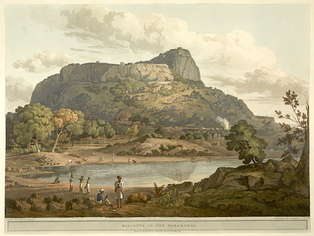
RAYAKOTTAI BY HENRY SALT


HENRY SALT (1780-1827) Rayakottai (No elevation data) India (Tamil Nadu)  In " Riacotta in the Baramahal,' aquatint, from

HENRY SALT (1780-1827)
Rayakottai (No elevation data)
India (Tamil Nadu)

In " Riacotta in the Baramahal,' aquatint, 1806, from  
Twenty Four Views in St. Helena, the Cape, India, Ceylon, the Red Sea, Abyssinia and Egypt, 
 The British Library


About the plate
This aquatint was taken from plate 12 of Henry Salt's Twenty Four Views in St. Helena, the Cape, India, Ceylon, the Red Sea, Abyssinia and Egypt. Salt visited Rayakottai in Tamil Nadu on his way to the Cauvery Falls. Viscount Valentia George Annesley wrote of its importance as a point of communication between Mysore and the Carnatic: "[Governor General] Lord Cornwallis ... had the fortifications strengthened. At present they consist of the hill, whose top is only approachable by a narrow flight of steps, and a fort at the bottom where are very comfortable houses for the officers. The scenery is wild and abrupt, consisting of rocky hills, with woods and jungle between ... the climate is so moderate, that every kind of fruit and vegetable may be reared in a degree of perfection that is unknown on the sultry plains around Madras.". For some reason, this impressed the british  by the fact it was " as high as a mountain". So.... do I year mountain ?

The place
Rayakottai, also spelled Rayakotta is not not really what we can alled a mountain, but a hill or a ridge like there are many others in this blog.  In reality it is a fort ! But it is designed quite like a mountain !!! It is located neat a town in Denkanikottai taluk, Krishnagiri District, Tamil Nadu, India. It is 73 kilometres (45 mi) from Bangalore.  The fort was built by King Krishna deverayar and situated within the town of Rayakottai which is one of the ancient fortress in the Krishnagiri district. It is now one of the protected monument by the Archaeological Survey of India. In the 18th century Hyder Ali and Tipu sultan captured this fort. The fort was captured by Major Gowdie during the third Anglo-Mysore War in 1791. According to the Treaty of Srirangapatna, this fort came into the hands of the British. 

The artist
Henry Salt was an English artist, traveller, collector of antiquities, diplomat, and Egyptologist.
After a time as a portrait painter, Salt was permitted to travel with the English nobleman George Annesley, Viscount Valentia as his secretary and draughtsman after being recommended by Thomas Simon Butt. They started on an eastern tour in June 1802, traveling on the British East India Company's extra (chartered) ship Minerva to India via the Cape Colony. In 1805, Valentia sent Salt on a journey into the Abyssinian area (now Ethiopia) to meet with the ras of Tigré to open up trade relations on behalf of the English. While visiting there, Salt gained the respect of the ras. He returned to England on 26 October 1806. His journey home took him through Egypt where he met the pasha Mehmet Ali. Salt's paintings from the trip were used in Valentia's Voyages and Travels to India, published in 1809. The originals of all the drawings were kept by Valentia, as also the copper plates after Salt's death. The format and style of the plates is similar to Thomas and William Daniell's work, "Oriental Scenery" (1795-1808).
Salt returned to Ethiopia in 1809 on a government mission to explore trade and diplomatic links with the Tigrayan warlord Ras Wolde Selassie. Upon arrival, he was unable to meet with the king due to unrest in the country, so instead he went to stay with his friend the ras of Tigré. During this venture, Salt took on the side mission of verifying and correcting the information about the region reported by the Scottish traveler, James Bruce many years earlier. Salt came back to England in 1811 with numerous specimens of both plants and animals.

___________________________________________
2021 - Wandering Vertexes...
by Francis Rousseau


Wednesday, August 18, 2021

MOUNT KOLSASS PAINTED BY CLAUDE MONET


CLAUDE MONET (1840-1926) Kolsås or Kolsass mountain (342 m - 1,122 ft) Norway  In "Le village de Sandviken, près du Mount Kolsaas" Norvège, 1895, Huile sur toile 73,4 x92, 5 cm - Art Institute Chicago


CLAUDE MONET (1840-1926)
Kolsås or Kolsass mountain (342 m - 1,122 ft)
Norway

In "Le village de Sandviken, près du Mount Kolsaas" Norvège, 1895, Huile sur toile 73,4 x92, 5 cm - Art Institute Chicago


Monet and Mount Kolsass
A text in french from the book Claude Monet, une vie dans le paysage by Marianne Alphant - Editions Hazan, 1993. (You may use the Google translation tool in this blog to tranlaste into your own langage)
« Au cours l'hiver 1895 le peintre français fit un séjour en Norvège. et peignit a plusieurs reprises à différentes heures du jour et dans différentes conditions climatiques une montagne, le mont Kolsaas. Mais sitôt réalisées leur auteur n'en fut guère satisfait et elles furent vite éclipsées par l'exposition des Cathédrales. Des vingt-sept ou vingt-huit qui furent recensées, le musée Rodin n'en propose qu'une douzaine, issues de collections publiques (Orsay, Marmottan) aussi bien que privées (Japon, Etats-Unis) et déjà présentées à Stavanger, en Norvège.
Monet effectua ce long voyage vers le Nord sur l'invitation de son beau-fils Jacques Hoschedé, pour saisir quelques effets de neige qu'il escomptait bien capter facilement là-bas. En quoi il se trompait généreusement, erreur à l'origine d'un de ses plus intéressants ratages.
Les quatre «portraits» du mont Kolsaas sont assez intrigants en ce que l’on y perçoit tout l'art du peintre pour «rendre» l'impalpable bien que cela l'entraînent vers des contrées inexplorées. « Le motif se met à flotter dans une atmosphère qui ne le porte plus, ne le soutient plus, l'abandonnant au gré d'une humeur vagabonde, à la manière d'un nuage libre de dériver au gré des vents. L'impression d'échec provient alors d'une incapacité à arrimer la figure, à saisir l'objet à bras le corps, à se tenir d'aplomb face à ce qui le surplombe. Mais la valeur inestimable de cet apparent échec excède largement cet effet de brouillon. (…)
Les peintures ne doivent pas leur sentiment d'incomplétude à une quelconque précipitation mais bien plutôt au désir de se fondre dans un immense éloge à la blancheur. (…)
Le mont Kolsaas ressemble de la sorte au dernier souffle ou à l'éternuement d'un linceul qui, l'instant suivant, s'affaissera dans l'indéterminé d'une forme sans contour. Autrement dit, l'informe. Ces quelques peintures représentent sans doute l'une des rares tentatives de distinguer la neige de la blancheur, de séparer les deux corps comme on le ferait dans une expérience chimique de dissociation. Car la neige n'est pas blanche, pas plus que le blanc n'est la couleur de la neige. L'un et l'autre entrent doucement en conflit pour que, dans l'intervalle, à la faveur d'une anecdote ­ petit pont ou rivière ­, se glisse l'élément qui permettra de rassurer la vision. Entre la neige et la blancheur, il y a un mariage fatal qu'il faut à tout prix éviter faute de s'y endormir. Entre le ciel et le bleu, c'est pareil mais c'est une autre histoire. Les deux histoires se rejouent chaque fois qu'un peintre essaie de fixer leur frontière, leur bord extrême. Comment cette peinture pourrait-elle alors s'achever ?."


The mountain
Kolsås or Kolsass Mountain (342 m - 1,122 ft) is a wooded mountain ridge in the municipality of Bærum, Norway. Geologically, Kolsås belongs to the Oslo Graben area. Its two peaks (one at 387m the other at 342m) consist of hard rhomb porphyric lava covering softer rocks, forming steep cliffs to the east, south and west. An old farm beneath the mountain has the name Kolsberg. The first element in this name is the genitive case of the old male name Kolr, and the last element is "berg" (mountain). The parish and municipality of Bærum (Old Norse Bergheimr) is probably named after this prominent mountain. The last element in the name of the mountain was later changed to ås (mountain ridge) to distinguish it from the name of the farm.
The French painter Claude Monet painted Mont Kolsaas in 1895 in a series of 4 paintings  one is permanently shown at the Musée d’Orsay , an other in Musée Marmottan. in Paris The 2 others shows on this blog are held in private collections in USA and Japan.

The painter
The painter Oscar-Claude Monet better known as Claude Monet was a founder of French Impressionist painting, and the most consistent and prolific practitioner of the movement's philosophy of expressing one's perceptions before nature, especially as applied to plein-air landscape painting. The term "Impressionism" is derived from the title of his painting « Impression, soleil levant » (Impression, Sunrise), which was exhibited in 1874 in the first of the independent exhibitions mounted by Monet and his associates as an alternative to the Salon de Paris.
Monet's ambition of documenting the French countryside led him to adopt a method of painting the same scene many times in order to capture the changing of light and the passing of the seasons exactly like the japanese artist Hokusai (1760-1849) did with his 36 views of Mount Fuji.
  Monet repeated this kinf of "exercise de stylee with his series on Les Petites Dalles.

 
___________________________________________

2021 - Wandering Vertexes...
by Francis Rousseau


Wednesday, June 9, 2021

JABAL AN-NOUR PAINTED BY NICHOLAS ROERICH


NICHOLAS ROERICH (1874-1947) Jabal an-Nour (640m -2,100ft) Saudi Arabia  In Mohammed on Mount Hira. 1925.Tempera on canvas. 73.6 x 117 cm, Roerich Museum, NYC

NICHOLAS ROERICH (1874-1947)
Jabal an-Nour (640m -2,100ft)
Saudi Arabia

In Mohammed on Mount Hira. 1925.Tempera on canvas. 73.6 x 117 cm, Roerich Museum, NYC


The mountain
Jabal an-Nour ( 640 m -2,100 ft) meaning Mountain of the Light or Hill of the Illumination, is a mountain near Mecca in the Hejazi region of Saudi Arabia. The mountain houses the grotto or cave of Hira' which holds sacred significance for Muslims throughout the world, as the Islamic prophet Muhammad is said to have spent time in this cave meditating, and it is widely believed that it was here that he received his first revelation, which consisted of the first five ayats of Surah Al-Alaq from the angel Jibra'il (as is pronounced in certain Quran recitation schools and some Arab tribes; also known as Gabriel.  It is one of the most popular tourist attractions in Makkah. Nonetheless one to two hours are needed to make the strenuous hike to the cave. There are 1750 steps to the top which, even for a fit individual, can take anywhere between half an hour and one-and-a-half hours. One physical feature that differentiates Jabal al-Nour from other mountains and hills is its unusual summit, which makes it look as if two mountains are on top of each other. The top of this mountain in the mountainous desert is one of the loneliest of places. However, the cave within, which faces the direction of the Kaaba, is even more isolated. While standing in the courtyard back then, people could only look over the surrounding rocks. Nowadays, people can see the surrounding rocks as well as buildings that are hundreds of meters below and hundreds of meters to many kilometers away. Hira is both without water or vegetation other than a few thorns. Hira is higher than Thabīr and is crowned by a steep and slippery peak, which Muhammad with some companions once climbed. Taking 1750 walking steps to reach, the cave itself is about 3.7 m (12 ft) in length and 1.60 m (5 ft 3 in) in width. The cave is situated at a height of 270 m (890 ft).  During the season of Ḥajj ('Pilgrimage'), an estimated five thousand visitors climb to the cave daily to see the place where Muhammad is believed to have received the first revelation of the Quran on the Night of Power by the angel Jibreel. 

The painter
Nicholas Roerich known also as Nikolai Konstantinovich Rerikh (Никола́й Константи́нович Ре́рих) is quite an important figure of mountain paintings in the early 20th century. He was a Russian painter, writer, archaeologist, theosophist, perceived by some in Russia as an enlightener, philosopher, and public figure. In his youth was he was quite influenced by a movement in Russian society around the occult and was interested in hypnosis and other spiritual practices. His paintings are said to have hypnotic expression. In

 __________________________________________

2021 - Wandering Vertexes / Mountain paintings
By Francis Rousseau

Sunday, May 9, 2021

CEMBA VELLEY PAINTED BY ALBRECHT DÜRER


ALBRECHT  DÜRER (1471-1528) Cemba Valley (200 m -656 ft) Italy   In Landscape near Segonzano in the Cembra Valley (1495), Watercolor on paper, 21 x 31.2 cm. The Ashmolean Museum, Oxford

ALBRECHT  DÜRER (1471-1528)
Cemba Valley (200 m - 656 ft)
Italy

 In Landscape near Segonzano in the Cembra Valley (1495), Watercolour on paper, 21 x 31.2 cm.
The Ashmolean Museum, Oxford


About this watercolor

Dürer called this landscape watercolor, which was created during his second Italian journey, "wehlsch pirg" (Italian hills). Its topographical location was long disputed. The most convincing suggestion is that this is a depiction of the Cembra Valley near Segonzano. The free manner in which the scene is captured, with the relaxed light brushstrokes in the foreground while the background is recorded with a naturalistic delicacy, makes it understandable why Dürer's watercolor technique at this time has been compared with that of Paul Cézanne. Watercolours by Dürer mark him as one of the first European landscape artists, while his woodcuts revolutionized the potential of that medium.


The valley
Trentino Alto Adige is the northernmost Italian region and is overwhelmingly mountainous, marked by the steep and picturesque shapes of the Dolomites, with the exception of the Adige Valley and the Dei Laghi Valley, both located below 200 m altitude and therefore considered as a plain. These valleys include large flat areas such as Piana Rotaliana and Piana dell'Alto Garda. While in the southern part of the region, on the shores of Lake Garda, the altitude drops to 65m, the highest mountain ranges peak at over 3,900m. The topographic prominence thus reaches almost 4,000 m. The region is bordered to the east and southeast by Veneto, to the west and southwest by Lombardy, to the north and northeast by the Austrian Land of Tyrol and Salzburg, and to the north -west with the Swiss canton of Graubünden 2. Predoi is the northernmost municipality in the region and in Italy; the municipality is the only one in Italy to be located further north than the 47th parallel.
The region lies between the central and eastern Alps, while to the south the border is delimited by Lake Garda and the Vicentine Pre-Alps.


The artist
Within three months of his marriage, Dürer left for Italy, alone, perhaps stimulated by an outbreak of plague in Nuremberg. He made watercolour sketches as he traveled over the Alps. Some have survived and others may be deduced from accurate landscapes of real places in his later work, for example his engraving Nemesis. In Italy, he went to Venice to study its more advanced artistic world. Through Wolgemut's tutelage, Dürer had learned how to make prints in drypoint and design woodcuts in the German style, based on the works of Schongauer and the Housebook Master. He also would have had access to some Italian works in Germany, but the two visits he made to Italy had an enormous influence on him. He wrote that Giovanni Bellini was the oldest and still the best of the artists in Venice. His drawings and engravings show the influence of others, notably Antonio Pollaiuolo, with his interest in the proportions of the body; Lorenzo di Credi; and Andrea Mantegna, whose work he produced copies of while training. Dürer probably also visited Padua and Mantua on this trip.  Albrecht Dürer was a German painter, printmaker, and theorist of the German Renaissance. Born in Nuremberg, Dürer established his reputation and influence across Europe in his twenties due to his high-quality woodcut prints. He was in contact with the major Italian artists of his time, including Raphael, Giovanni Bellini and Leonardo da Vinci, and from 1512 was patronized by Emperor Maximilian I. Dürer's vast body of work includes engravings, his preferred technique in his later prints, altarpieces, portraits and self-portraits, watercolours and books. The woodcuts series are more Gothic than the rest of his work. His well-known engravings include the three Meisterstiche (master prints) Knight, Death and the Devil (1513), Saint Jerome in his Study (1514) and Melencolia (1514). Dürer's introduction of classical motifs into Northern art, through his knowledge of Italian artists and German humanists, has secured his reputation as one of the most important figures of the Northern Renaissance. This is reinforced by his theoretical treatises, which involve principles of mathematics, perspective, and ideal proportions.

_______________________________
2021 - Wandering Vertexes...
by Francis Rousseau 

Wednesday, May 5, 2021

LA TETE D'AUGUSTE PAINTED BY PAUL CEZANNE

PAUL CEZANNE (1839-1906)
 La Tête d'Auguste (278m
 - 912ft) France (Bouche du Rhône)
  In Au fond du ravin, L’Estaque, 1882 Huile sur toile, 73 x 54 cm, The Museum of Fine Arts, Houston

PAUL CEZANNE (1839-1906)

La Tête d'Auguste (278m
 - 912ft)
France (Bouche du Rhône)


In Au fond du ravin, L’Estaque, 1882 Huile sur toile, 73 x 54 cm, The Museum of Fine Arts, Houston


The Hill
The Tête d'Auguste (278m - ) is the highest point of the Chaîne de l'Estaque or the Nerthe chain, a massif of white limestone hills around 28 kilometers long which extends from L'Estaque to Martigues. The Estaque chain is part of the Pyrenean-Provençal chain, a former massif which stretched continuously before the Oligocene, from the Pyrenees to the Estaque massif, in place of the current Gulf of Lion. Nowadays, it forms a sort of isthmus about 8 kilometers wide between the Mediterranean Sea to the south and the Etang de Berre to the north.
The coastline of the Estaque range forms the Côte Bleue with its steep shores cut into deep creeks. The railway line from Miramas to Estaque runs along the coast clinging to the side of the massif. The Estaque range is also home to several gray limestone quarries, two of which are exploited for the manufacture of lime, the others for the general and aggregates and other quarry products (Lafarge).


The painter

The mount Sainte-Victoire appears to have been the subject of a true love story with the painter (Paul Cézanne). He painted this subject more than 80 times, in oil paintings, watercolors and drawings ! but he diddn't painted only the Sainte Victoire... others landscape and mountains of Provence were in his mind too... 
Cézanne had a considerable influence on the art of the late nineteenth and the early twentieth century. Acknowledged master of his time, he attended during stays in Paris between 1862 and 1882, the Impressionist band: Camille Pissarro, Auguste Renoir (who also ended his life in the Provencal brightness), Claude Monet, Alfred Sisley and others. He participated in the Impressionist adventure while keeping his personality: it is the time of the shock of the en plein air, easels in the grass, looking for natural light and emotion. 
The influence of the Aix painter is recognized in the history of art since it would be the cause of the Cubist movement embodied in 1906 by Pablo Picasso and Georges Braque. The first historically so called Cubist painting ' Les Demoiselles d'Avignon' would, a true artistic shock shown by Picasso in 1907 (one year after the death of Cézanne) is today one of the masterpieces of the MoMA in New York. 
It is the search of volumes around which leads to the appearance of geometry in landscapes or still lifes of Cézanne.In 20 years, Cézanne pushes his style to express the emotion of the landscape, suggesting the wind, involving movement just like if we can breathe the air of the scene.


__________________________________________
2021 - Wandering Vertexes...
by Francis Rousseau

Sunday, February 21, 2021

CHENOUA PAINTED BY MARIUS DE BUZON

https://wanderingvertexes.blogspot.com/2021/02/chenoua-painted-by-marius-de-buzon.html

MARIUS DE BUZON (1879-1958)
Chenoua (905 m- 2969 ft)
Algeria

In La Côte d'Alger aux Environs de Tipiza, oil on canvas, 1951, Private collection


The mountain
The Chenoua (905 m- 2969ft) in Berber: Adrar n Cenwa) is a mountain located in the region of Tipaza, in the north of Algeria. The massif of Mount Chenoua is, in the west, the highest point of the hills of the Algiers Sahel. It is surrounded to the east by Wadi Nador, Tipaza river and to the west by Wadi El Hachem, Cherchell river. By joining the sea, the Chenoua forms an alternation of cliffs and beaches, visible from the panoramic road that runs along the Mediterranean. The Chenoua corniche, which stretches as far as Cherchell (Caesarea), is home to small picturesque beaches. Cape Chenoua or Ras el Amouch offers a view of the bay and a walk in the caves of the cliff. Marble is taken from the Chenoua quarries. The novels by Albert Camus : "La mort heureuse"  and "Noces " are partly set in  the Chenoua.

The painter
Marius de Buzon is a French painter of the school of Algiers of Spanish ancestry, descendant of Francisco de Goya. In 1939, the well known french journalist and writer Max-Pol Fouchet said about him in Algeria : "The praise of M. de Buzon seems to me useless to do. We know the serious and powerful art of this painter, but he also knows how to release on his canvases a Corotian tenderness before such a French landscape. He moves only more." While according to Victor Barrucand, "he highlighted the essential lines of the landscapes, sculpting large swathes of the Kabyles valleys " .
He is knighted by the Legion of Honor.
He is considered, and quoted, as the "cantor of Kabylie" and one of the founders of the School of Algiers (following Maxime Noiré, and with Léon Carré, Léon Cauvy, Paul Jouve). He also paints landscapes and types of the region of Bougie, the Mzab (where he is one of the first painters to enter, after Étienne Dinet, with Maurice Bouviolle, Touggourt where he regularly stays after 1945 (L'Heure Blonde, 1950), Témacine (1953), and Sidi Bou Saïd, or Spain and Morocco, Casablanca, Rabat or Fez.
His works are highly sought after by collectors as representing scenes of Kabyle life, landscapes, pastoral scenes; "He substitutes for the notion of ethnic identification, that infinitely more poetic allegory " wrote Élisabeth Cazenave, while in 1930 Pierre Angel : "Marius de Buzon continued on these African shores the ancient dreams of the pagan mysticism. "
Marius de Buzon died at the end of November 1958 in Algiers; his son Jean and grandson Jean-Frédéric were murdered in 1962 while trying to move and save the workshop of their father and grandfather.

___________________________________________

2021 - Wandering Vertexes...
by Francis Rousseau


Sunday, February 14, 2021

UNDOOLYA PAINTED BY ALBERT NAMATJIRA


https://wanderingvertexes.blogspot.com/2021/02/undoolya-painted-by-albert-namatjira.html

ALBERT NAMATJIRA (1902-1959)
Undoolya (794 m - 2,606 ft)
Australia (Northern Territory) 

 In  Undoolyia range, watercolor, 1947


The mountain
Undoolya or Mount Undoolya (794 m- 2,606 ft) is located in the MacDonnell region and the Northern Territory state, in the central part of Australia, 1,900 km north-west of Canberra is the nation's headline. The ground around Mount Undoolya is usually flat, but on the east it is the hills. The surrounding area has an altitude of 871 meters and 14.8 km north of Mount Undoolya. Nor more than 2 people per square kilometer around Mount Undoolya. No city around. Mount Undoolya is surrounded by lakes. The climate is warm.


The Painter
Albert Namatjira born Elea Namatjira, was a Western Arrernte-speaking Aboriginal artist from the MacDonnell Ranges in Central Australia. As a pioneer of contemporary Indigenous Australian art, he was the most famous Indigenous Australian of his generation.
Born and raised at the Hermannsburg Lutheran Mission outside Alice Springs, Namatjira showed interest in art from an early age, but it was not until 1934 (aged 32), under the tutelage of Rex Battarbee, that he began to paint seriously. Namatjira's richly detailed, Western art-influenced watercolours of the outback departed significantly from the abstract designs and symbols of traditional Aboriginal art, and inspired the Hermannsburg School of painting. He became a household name in Australia—indeed, reproductions of his works hung in many homes throughout the nation—and he was publicly regarded as a model Aborigine who had succeeded in mainstream society.
Although not the first Aboriginal artist to work in a European style, Albert Namatjira is certainly the most famous. Ghost gums with luminous white trunks, palm-filled gorges and red mountain ranges turning purple at dusk are the hallmarks of the Hermannsburg school. Hermannsburg Mission was established by Lutheran missionaries in 1877 on the banks of the Finke River, west of Mparntwe (Alice Springs). Namatjira learnt watercolour technique from the artist, Rex Battarbee.


_______________________________

2021 - Wandering Vertexes...
by Francis Rousseau

Sunday, January 31, 2021

THE DENTELLES DE MONTMIRAIL PAINTED BY A. G. CARRICK / H.M KING CHARLES III


https://wanderingvertexes.blogspot.com


A. G. CARRICK / H.M KING CHARLES III former PRINCE OF WALES (bn.1948)
Les Dentelles de Montmirail (734m - 2,400 ft)
France (Vaucluse)

In Les Dentelles de Montmirail from Le Barroux, watercolor, Priaate coillection


The mountains
The Dentelles de Montmirail (734 m - are a small chain of mountains in Provence in France, in the département of Vaucluse, located just to the south of the village of Vaison-la-Romaine. They are foothills of the highest peak in Provence, Mont Ventoux, which is situated just to the east. The dramatically jagged shape of their peaks was formed by horizontal strata of Jurassic limestone being folded and forced into a nearly upright position and subsequently eroded into sharp-edged ridges and spikes. The highest peak of the Dentelles is St-Amand, at 734 m (2,400 ft). The range, which is about 8 km wide, offers over 600 trails for walking, rock climbing, and mountain biking.]The foot of the Dentelles is surrounded by vineyards of the Rhône Valley. Their name Dentelles, the French word for "lace," refers to their shape obtained by erosion, while Montmirail is derived from the Latin mons mirabilis meaning 'admirable mountain'.
Located on the territory of the communes of Beaumes-de-Venise, Crestet, Gigondas, La Roque-Alric, Lafare, Le Barroux, Malaucène, Suzette, and Vacqueyras; the Dentelles de Montmirail were an important natural frontier during Antiquity between the tribes of the Memini in the south, and the Voconces in the north. 

The painter
Arthur George Carrick is actually H.M. the King Charles III, former Prince of Wales.
When he began showing his paintings, he was too nervous to display his name so displayed under a pseudonym. Arthur George are two of his names (Charles Phillip Arthur George) and one of his titles is Earl of Carrick. King Charles III is an experienced watercolourist.  He has been painting for most of his adult life, during holidays or when his official diary allows. King Charles' interest began during the 1970s and 1980s when he was inspired by Robert Waddell, who had been his art master at Gordonstoun in Scotland. In time, King Charles met leading artists such as Edward Seago, with whom he discussed watercolour technique, and received further tuition from John Ward, Bryan Organ and Derek Hill.
The Royal Family has a tradition of drawing and painting, and King Charles’ work first came to public notice at a 1977 exhibition at Windsor Castle at which other Royal artists included Queen Victoria, The Duke of Edinburgh and The Duke of York.
King Charles paints in the open air, often finishing a picture in one go and his favourite locations include The Queen's estate at Balmoral in Scotland and Sandringham House in Norfolk, England. Sometimes King Charles  III paints during his skiing holidays, and during overseas tours when possible.
The copyright of King Charles' watercolours belongs to A. G. Carrick Ltd, a trading arm of The King's Charities Foundation. Over the years King Charles III has agreed to exhibitions of his watercolours and of lithographs made from them, on the understanding that any income they generate goes to The Prince of Wales's Charitable Foundation.
Money from the sale of the lithographs also goes to the Foundation but the paintings themselves are never for sale.
In the 1980s King Charles III, then Prince of Wales,  began inviting young British artists to accompany him on official tours overseas and record their impressions, a tradition that has continued to this day.
Reference :
- The prince of Wales paintings 

______________________________

2021 - Wandering Vertexes...
by Francis Rousseau


Thursday, January 7, 2021

MOUNT BURKE & BAY OF ISLANDS PAINTED BY FRANKLIN CARMICHAEL

https://wanderingvertexes.blogspot.com/2021/01/mount-burke-bay-of-islands-painted-by.html


FRANKLIN CARMICHAEL (1890–1945)
Mount Burke (1,270 m  - 4,167 ft)
Canada (British Columbia)

In Bay of Islands from Mt. Burke, 1931, oil on canvas, 101.6 x 122.0 cm, 

McMichael Canadian Art Collection


The mountain

Mount Burke (1,270 m (4,167 ft), is a mountain located in northeast Coquitlam, British Columbia, north of Port Coquitlam on the ridge system leading to Coquitlam Mountain. Most of the mountain is part of Pinecone Burke Provincial Park.   Mount Burke was named for Edmund Burke by Captain George Henry Richards of HMS Plumper while surveying Burrard Inlet in 1859.
The mountain was placed in Pinecone Burke Provincial Park on the park's creation in 1995.
Many people confuse Mount Burke, with the much higher and larger Burke Ridge, which is more commonly known as Burke Mountain, and in the 1920s Burke Ridge was more commonly known as Dollar Mountain, after the Canadian Robert Dollar Company, who logged the lower portions of the mountain.

The artist
Franklin Carmichael was a Canadian artist and member of the Group of Seven. Though he was primarily famous for his use of watercolours, he also used oil paints, charcoal and other media to capture the Ontario landscapes of which he was fond. Besides his work as a painter, he worked as a designer and illustrator, creating promotional brochures, advertisements in newspapers and magazines, and stylizing books. Near the end of his life, Carmichael taught in the Graphic Design and Commercial Art Department at the Ontario College of Art (today the Ontario College of Art and Design). The youngest original member of the Group of Seven, Carmichael often found himself socially on the outside of the group. Despite this, the art he produced was of equal measure in terms of style and approach to the other members' contributions, vividly expressing his spiritual views through his art.  Carmichael was a passionate landscape painter. Many of his paintings depict the trees, rocks, hills, and mountains of Ontario. His earlier works had flat juxtapositions of colour, but as he matured through the 1920s he emphasized depth and three dimensional space. Beyond simple representation of picturesque views, Carmichael attempted to capture contrast.  Contemporary Emily Carr wrote that Carmichael's work was, "A little pretty and too soft, but pleasant."Carmichael was a member of the Royal Canadian Academy of Arts.  In 1952, Dr. Ann Curtin and Carmichael's widow founded the Franklin Carmichael Art Group, now located at 34 Riverdale Drive in Toronto.


__________________________________________

2021 - Wandering Vertexes / Mountain paintings
By F rancis Rousseau


Friday, January 1, 2021

VICTORIA PEAK PAINTED BY ERNEST CHARTON DE TREVILLE


ERNEST CHARTON DE TREVILLE (1816-1877)
Victoria Peak  (552 m -1,811 ft)
China (Hong Kong)
 
In Victoria Peak vu de la Baie de Hong Kong, Oil on canvas, Private collection 

The mountain
Victoria Peak (552 m -1,811 ft) or 太平山 (in Chinese) also locally called The Peak or Mount Austin an sa few others cantonese and Hong Kong Hakka names such as Taai Pen Saa or Deng or Saan Deng or Ce Kei Saan or Lou Fung... is a mountain in the western half of Hong Kong Island. It is the highest mountain on Hong Kong island, ranked 31 in terms of elevation in the Hong Kong Special Administrative Region ; Tai Mo Shan (957m) being the highest point in the Hong Kong Special Administrative Region.The summit is occupied by a radio telecommunications facility and is closed to the public. However, the surrounding areaf public parks and high-value residential land is the area that is normally meant by the name The Peak. During the19th century, the Peak attracted prominent European residents because of its panoramic view over the city and its relatively temperate climate compared to the sub-tropical climate in the rest of Hong Kong. The sixth Governor of Hong Kong, Sir Richard MacDonnell had a summer residence built on the Peak circa 1868. Those that built houses named them whimsically, such as The Eyrie, and the Austin Arm. These original residents reached their homes by sedan chairs, which were carried up and down the steep slope of Victoria Peak.

The painter
Ernest-Marc-Jules Charton Thiessen of Treville better known as Ernest Charton or Ernesto Charton was a French painter, famous for his pastel portraits and realistic- style customary paintings. He made most of his artistic career in South America - particularly in Argentina Chile and Ecuador -, a continent where his first name, as was customary at the time, was Castilianized, which is why he was known as Ernesto Charton.
He was initially established in Valparaíso (Chile), but in 1848 he moved to Santiago where he opened a studio neighboring that of Raymond Monvoisin, another French pioneer of Chilean painting and also belonging to traveling artists as was also at that time the watercolorist Carlos Wood.
Brother of Edouard Charton, director of the Parisian magazine Le Tour du Monde Ernesto was a typical adventurous artist of the nineteenth century in search of the most exotic expressions of unexplored nature, following in this aspect the motivation of numerous European painters of the time.  Many of his American experiences were reflected in the L'llustration, a magazine also directed by his brother and of which he was a correspondent, sending not only chronicles but also drawings, such as those he sent from the streets of Valparaíso before the bombing. He also sent a drawing of the bombing of Callao, which was recorded by Louis Le Breton and published on June 23.
Tempted by the gold rush in California he embarked on October 25, 1848 on the schooner Rosa Segunda, who arrived in the Galapagos Islands within two weeks to get water; when most of the passengers were ashore, the ship abandoned them to their fate. The painter, like his companions, lost everything, including his works.
Charton, who in 1862 would return to Ecuador, managed to settle in Quito with the help of the French consul. He taught drawing and painting at the University of that city; in addition, he directed the Miguel de Santiago Liceo of Painting, a direct antecedent of the School of Fine Arts of that country. As a result of his stay in Ecuador, he left a 48-watercolors album (cf. above)
He returned to France, but in 1855 he returned to Chile with his family; he gained fame as a portraitist, landscaper and teacher. In this last quality he had a famous controversy with the first director of the Academy of Painting of Santiago. ]
In 1870 he left Chile to Argentina, crossing the Andes. From that experience, his large oil painting was born the following year View of the Andes mountain range (115x197cm) that is today in the National Museum of Fine Arts of that country, in Buenos Aires, city where he settled until his death.
In addition to the countries mentioned, he travelled in Italy, Panama (when it was still part of Colombia) Peru and China (Hong Kong, Macao) (see above). 
As a Photographer, he used snapshots as a base for his paintings, portraying typical clothes, customs and parties that he then tracked to the web.
Charton's works are characterized by their vibrant color and the realistic expression of popular customs and motifs. He left among his students from Chile, Ecuador and Argentina this cultural vision of pictorial realism applied to the theme of each country, leaving aside religious, mythological or literally copied motifs of European models.
His paintings can be seen in museums in Argentina, Chile and Ecuador.

__________________________________________

2021 - Wandering Vertexes / Mountain paintings
By F rancis Rousseau


___________________________________

2021 - Wandering Vertexes
A blog by Francis Rousseau

Wednesday, December 16, 2020

MONT GAUSSIER (4) AND THE ALPILLES BY VINCENT VAN GOGH


VINCENT VAN GOGH (1853-1890) Mont Gaussier (306 m -1,004 ft) France  In Mas au milieu des oliviers dans les Alpilles, St Rémy de Provence, oil on canvas, 1889,  Private collection


VINCENT VAN GOGH (1853-1890)
Mont Gaussier (306 m -1,004 ft)
France

In Mas au milieu des oliviers dans les Alpilles, St Rémy de Provence, oil on canvas, 1889, 
Private collection


About the painting
During his internment in the Saint-Paul-de-Mausole asylum in Saint-Rémy-de-Provence, Van Gogh seized the surroundings to nourish his artistic geography. He tirelessly paints and draws new Provencal motifs: cypress trees, olive groves and hills. With the Alpilles chain and the Mont Gaussier rising behind the asylum buildings, the painter has the opportunity to represent this mountain range as well as the farms (Mas in french) nearby.  I this one the Mont Gaussier is in the background of the farm, probably situated on theVia Aurelia, the antique roman road going from St Rémy de Provence to Arles...  

The mountain
The Mont Gaussier (306 m -1,004 ft) is a summit of the Alpilles located south of the city of Saint-Rémy-de-Provence, France. Today, the place of passage of many hikers who cross it by the GR6, Mount Gaussier was very early used as habitat by protohistoric populations, before having at its summit a medieval castle, nowadays disappeared. Mount Gaussier is made of crystalline limestone, white and hard. One finds in the soil the trace of many fossils. This type of summit is characteristic of the Alpilles range of mountains, especially on the north face.
The first traces of habitation on Mount Gaussier are ancient. In 1996, three sites dating from Protohistory were discovered at the summit and on the slopes. This is what emerges from the study of stones, tiles, ceramics and shards of amphora found on the premises. Moreover, the foundation of a wall was identified at the top during the same prospecting.
Most of the human activity of antiquity at Mount Gaussier nevertheless concentrated at the foot of it, since it was there that was built the Salyan city of Glanum (today Saint-Remy de Provence). Research carried out in 1996 and 1997 revealed that the well-preserved remains of a protohistoric rampart with towers have been cleared in several places, particularly on the ridges which dominate to the north-east and south-west the Saint-Clerg and at the foot of Mount Gaussier. The system of rampart which encircled the city in the 1st and 2nd centuries BC. J.-C. leaned on the cliffs of the mount Gaussier which border it on a hundred meters. It is also believed that Mount Gaussier, by its situation, could be used as an acropolis because of its plateau surrounded by cliffs and that its access from Glanum was made possible by a narrow corridor.
If, according to the archaeologist Henri Rolland, some families occupied the Alpilles range, on the slopes of Mount Gaussier, between the first Iron Age and the end of Antiquity, but also in the High Middle Ages, only the foot and the summit of the mountain were occupied in the following centuries, especially in the 5th and 6th centuries. It was here that a part of the inhabitants of Glanum took up residence after the ruin of the ancient city in the alluvial deposits of the mountain.
Mount Gaussier, like Glanum, then in ruins, and Saint-Remy-de-Provence, became property of the church of Avignon at the end of the 9th century in a county of Provence powered by Count Thibert.
It is possible to reach the Mount Gaussier from the ruins of Glanum or from La Caume by the GR6 climbing previously metal ladders.

The painter
Vincent Willem van Gogh was a Dutch Post-Impressionist painter who is among the most famous and influential figures in the history of Western art. In just over a decade he created about 2100 artworks, including around 860 oil paintings, most of them in the last two years of his life. They include landscapes, still lifes, portraits and self-portraits, and are characterized by bold, symbolic colours, and dramatic, impulsive and expressive brushwork that contributed to the foundations of modern art. He died by suicide at 37, following years of mental illness and poverty.
Born into an upper-middle-class family, Van Gogh drew as a child and was serious, quiet and thoughtful. As a young man he worked as an art dealer, often travelling, but became depressed after he was transferred to London. He turned to religion, and spent time as a missionary in southern Belgium. Later he drifted in ill health and solitude. He took up painting in 1881 having moved back home with his parents. His younger brother Theo supported him financially, and the two kept up a long correspondence by letter.
More about Vincent Van Gogh

_______________________________

2020 - Wandering Vertexes...
by Francis Rousseau