google.com, pub-0288379932320714, DIRECT, f08c47fec0942fa0 GRAVIR LES MONTAGNES... EN PEINTURE: GLACIERS
Showing posts with label GLACIERS. Show all posts

Monday, January 9, 2023

LA MONTAGNE BLEUE PEINTE PAR WASSILY KANDINSKY


WASSILY KANDINSKY  (1866-1944) "Der Blue Berge" - Alpspitze (2,628 m - 8,622ft) Allemagne (Bavière)

WASSILY KANDINSKY  (1866-1944)
"Der Blue Berge" - Alpspitze (2,628 m - 8,622ft)
Allemagne (Bavière)

In Paysage d'hiver, 1909 Huile sur carton,  70 x 97 cm. Musée de l'Hermitage Saint Petersbourg

La montagne
L'Alpspitze (2,628 m - 8,622ft) est une montagne de Bavière, en Allemagne. Son sommet pyramidal connu sous le nom de Montagne Bleue,  est le symbole de Garmisch-Partenkirchen et  l'un des plus repérables des Alpes du Nord. Il est constitué principalement de calcaire de Wetterstein du Trias supérieur.
Plusieurs routes permettent l'ascension de l'Alpspitze. La  plus courte commence à la station d'Osterfelderkopf (2 033 m) au téléphérique Alpspitze de Garmisch-Partenkirchen. Depuis l'Osterfelderkopf, l'Alpspitze peut être escaladé soit directement le long de l'Alpspitz-Ferrata, une route facile, protégée et très fréquentée (à environ 2 heures de l'Osterfelderkopf), soit le sommet peut être atteint par la montée de la face nord (Nordwandsteig), qui tourne en courbe vers l'est dans le cirque d'Oberkar et de là longe le bord gauche du cirque jusqu'au sommet.
Une autre ascension part du col de Grießkarscharte (2 460 m), que l'on atteint soit depuis le refuge Höllentalanger dans la vallée de Höllental via le cirque de Mathaisenkar soit depuis le lac de Stuibensee via le cirque de Grießkar.

Le peintre
Wassily Wassilyevich Kandinsky (Васи́лий Васи́льевич Канди́нский) était un peintre franco-russe et théoricien de l'art. On lui attribue la peinture de l'une des premières œuvres purement abstraites reconnues. Né à Moscou, Kandinsky a passé son enfance à Odessa, où il est diplômé de l'école d'art Grekov. Il s'est inscrit à l'Université de Moscou, étudiant le droit et l'économie. Il se voit rapidement offrir une chaire de professeur (chaire de droit romain) à l'Université de Dorpat. Kandinsky commence des études de peinture (dessin d'après nature, croquis et anatomie) à l'âge de 30 ans.
En 1896, Kandinsky s'installe à Munich, étudiant d'abord à l'école privée d'Anton Ažbe puis à l'Académie des Beaux-Arts.
Entre 1906 à 1908, il voyagea  beaucoup à travers l'Europe jusqu'à ce qu'il s'installe dans la petite ville bavaroise de Murnau. En 1908, il acheta un exemplaire de Thought-Forms d'Annie Besant et de Charles Webster Leadbeater. En 1909, il rejoint la Société Théosophique.
La Montagne bleue (1908-1909) -  on devrait dire d'ailleurs LES montagnes bleue car il a peint  plusieurs  ce même sujet à cette époque - montre sa nette évolution vers l'abstraction en moins de deux années. La large utilisation de la couleur dans ces tableaux illustre l'inclination de Kandinsky vers un art dans lequel la couleur commence à s'affranchir de la forme, et où chaque couleur est représenté avec la même attention, la même importance.
Après le déclenchement de la Première Guerre mondiale, Kandinsky quitte l'Allemagne pour Moscou. Indifférent aux théories officielles sur l'art dans la Russie communiste, il rentre rapidement en Allemagne en 1920, quelques années après la Révolution. Là, il a enseigné à l'école d'art et d'architecture du Bauhaus de 1922 jusqu'à ce que les nazis la ferment en 1933. Il s'installe ensuite en France, où il vécut pour le reste de sa vie, devenant citoyen français en 1939 et produisant certains de ses plus art de premier plan. Il meurt à Neuilly-sur-Seine en 1944.

 _________________________________________

2023 - Wandering Vertexes ....
            Errant au-dessus des Sommets Silencieux...
            Un blog de Francis Rousseau


Monday, December 12, 2022

LES ANDES ARGENTINES PEINTES PAR RHOD WULFARS


RHOD WULFARS (né en 1979) Andes du Sud (6 991 m - 22 838 pieds) Argentine  In Andes, acrylique sur panneau dur, 2018, Collection de l'artiste @rhodwulfars D'autres oeuvres de cet artiste sur son site : rhodwulfars.wixsite.com/rhodwulfars/

RHOD WULFARS (né en 1979)
Andes du Sud (6 991 m - 22 838 pieds)
Argentine

In Andes, acrylique sur panneau dur, 2018, Collection de l'artiste @rhodwulfars
D'autres oeuvres de cet artiste sur son site : rhodwulfars.wixsite.com/rhodwulfars/


L'artiste
Rhod Wulfars est un peintre de montagne contemporain utilisant principalement la technique acrylique pour ses peintures. Il est né en 1979 à Mendoza (Argentine). Sur son site Internet, il écrit : "J'ai passé toute ma vie près des montagnes. Un jour, j'ai commencé à les peindre". Utilisant, à la manière de Nicolas de Staël, un style toujours entre abstrait et figuratif, ses peintures très fortes et très émouvantes décrivent parfaitement la majesté et le contenu spectaculaire des sommets qu'il peint. Rhod Wulfars fait un usage surprenant du médium acrylique, en pâte épaisse comme on pourrait le faire avec de la peinture à l'huile. Il avait l'habitude de ne nommer ses œuvres que par des chiffres et des lettres de série, mais parfois il écrit le nom des sommets et le rend plus facile à identifier. 

A propos des tableaux
Le peintre écrit : " Ce n'est pas une vraie montagne. La plupart de mes peintures naissent de la combinaison de l'imagination et des heures passées à les regarder, à les parcourir et à les sentir. Elles  ressemblent à ces reliefs de la Coridilla andine argentine appelés "acarreos", qui sont de longues pentes de roche meuble très populaires et facilement visibles. très fréquemment observée. Ce tableau est donc celui d'une montagne inconnue, rêvée qui en résume plusieurs, et qui est sortie de mon inconscient un après-midi où le pinceau lui a donné vie de façon mystérieuse sans que je puisse l'expliquer. "  Le plus étonnant étant qu'ils le font d'un seul coup de pinceau aussi puissant et définitif que le soulèvement rocheux lui-même qui a crée ses reliefs. 


Les montagnes
Les Andes (Cordillera de los Andes en espagnol) sont la plus longue chaîne de montagnes continentales du monde, formant un plateau continu le long de la bordure ouest de l'Amérique du Sud. Leur étendue est de  7000 km (4350 mi) de long, 200 à 700 km (124 à 435 mi) de large (la plus large entre 18 ° S et 20 ° S de latitude) et d'une hauteur moyenne d'environ 4000 m (13123 pieds). Les Andes s'étendent du nord au sud à travers sept pays d'Amérique du Sud : le Venezuela, la Colombie, l'Équateur, le Pérou, la Bolivie, le Chili et l'Argentine.
La Cordillère des Andes est la plus haute chaîne de montagnes en dehors de l'Asie. La plus haute montagne en dehors de l'Asie, le mont Aconcagua en Argentine, s'élève à une altitude d'environ 6 961 m (22 838 pieds) au-dessus du niveau de la mer. Le pic du Chimborazo dans les Andes équatoriennes est plus éloigné du centre de la Terre que tout autre endroit à la surface de la Terre, en raison du renflement équatorial résultant de la rotation de la Terre. Les plus hauts volcans du monde se trouvent dans les Andes, y compris Ojos del Salado à la frontière Chili-Argentine, qui culmine à 6 893 m (22 615 pieds).
Les Andes font également partie de la Cordillère américaine, une chaîne de chaînes de montagnes (cordillère) qui consiste en une séquence presque continue de chaînes de montagnes qui forment la "colonne vertébrale" occidentale de l'Amérique du Nord, de l'Amérique centrale, de l'Amérique du Sud et de l'Antarctique.

 _________________________________________

2022 - Wandering Vertexes ....
            Errant au-dessus des Sommets Silencieux...
            Un blog de Francis Rousseau

Wednesday, November 30, 2022

MONT GEIKIE & LES REMPARTS PEINTS PAR LAWREN HARRIS


LAWREN S. HARRIS (1885-1970) Mont Geikie  - The Ramparts (3 ,98 m - 10, 820 ft)  Canada ( Colombie-Britannique )    In The Ramparts Tonquin Valley, Rocky Mountains huile sur panneau, 27,1x37,5cm,  Fondation Sobey pour les Arts, Canada

 LAWREN S. HARRIS (1885-1970)
Mont Geikie  - Les Remparts (3,298 m - 10, 820 ft)
Canada (Colombie-Britannique)
 
 In The Ramparts Tonquin Valley, Rocky Mountains huile sur panneau, 27,1x37,5cm, 
Fondation Sobey pour les Arts, Canada 

La montagne 
Le mont Geikie  (3,298 m - 10, 820 ft), prononcé comme " geek ", est un sommet montagneux situé en Colombie-Britannique au Canada. Situé à 28 km au sud-ouest de Jasper près de la vallée de Tonquin, le mont Geikie est le plus haut sommet de la chaine des  Remparts (Ramparts) dans les Rocheuses canadiennes, l'une des plus belles destinations de montagne au monde. Son sommet le plus élevé le plus proche est le mont Fraser à 8 km au sud-est ; le Continental Divide se trouve à 3 km à l'est.  Le mont Geikie est composé de quartzite de la période cambrienne, une  roche poussée vers l'est  au-dessus d'une roche plus jeune au cours de l'orogenèse Laramide.  Le mur vertical de sa face nord mesure plus de 1 500 mètresde haut et a été comparé aux autres grandes faces nord des Rocheuses canadiennes telles que North Twin, Alberta et Kitchener. Les  Remparts se trouvent en partie dans le Parc national de Jasper en Alberta et dans le parc provincial du mont Robson en Colombie-Britannique. 10 sommets font partie de cette chaine, dont le plus élevé est le mont Geikie  La plupart ont été nommés par le Club alpin du Canada et portent des noms sur le thème du génie militaire tels que Bastion, Parapet, Redoute et Dungeon.  Ils forment la limite ouest de la vallée de Tonquin. 
 
Le peintre
Lawren S. Harris  est né à Brantford, en Ontario, en 1885. La famille Harris a fondé l’entreprise de machinerie agricole Massey-Harris (aujourd'hui Massey Ferguson). C'est assez dire que les activités artistiques de Harris ne connaîtront jamais d’obstacle financier !  Dès l’enfance, il commence à dessiner et à peindre à l’aquarelle, puis il se rend à Berlin en 1904 pour y faire des études en arts. Harris devient un adepte de la philosophie théosophique, une interprétation mystique de la doctrine religieuse, qui joua un rôle déterminant dans sa vie et dans son oeuvre. Le style impressionniste de Harris utilise des couleurs riches et vives pour illustrer les thèmes récurrents de la beauté de la nature. Au fil des ans, son style évolue vers l’abstraction. Après avoir parcouru l’Europe et le Moyen-Orient, Harris revient au Canada à l’âge de 22 ans et s’établit à Toronto. Il s’investit activement dans l’Arts and Letters Club de Toronto, où il rencontre les autres membres du futur Groupe des Sept et partage avec eux les philosophies artistiques modernes qu’il rapporte de l’étranger. En 1913, de concert avec le Dr James McCallum, il finance la construction du Studio Building, sur la rue Severn, à Toronto, pour offrir à ces artistes un endroit où ils peuvent vivre et travailler ensemble, afin de créer un nouveau genre d’art canadien. Harris finance aussi de nombreux voyages à Algoma, en Ontario, et est considéré comme responsable de la formation officielle du Groupe des Sept. Il meurt en 1970.
 _________________________________________

2022 - Wandering Vertexes ....
            Errant au-dessus des Sommets Silencieux...
            Un blog de Francis Rousseau


Thursday, November 3, 2022

LE WATZMANN PEINT PAR ADALBERT STIFTER


ADALBERT STIFTER (1805-1868), Le Watzmann (2,713m - 8,901ft) Allemagne (Alpes bavaroises) In Der Königsee mit dem Watzmann,1837, huile sur toile


ADALBERT STIFTER (1805-1868),
Le Watzmann (2,713m - 8,901ft)
Allemagne (Alpes bavaroises)

In Der Königsee mit dem Watzmann,1837, huile sur toile

La montagne
Le Watzmann (2,713m - 8,901ft)) est massif montagneux  des Alpes bavaroises situé au sud de Berchtesgaden. C'est le troisième plus haut d'Allemagne et le plus élevé qui soit entièrement situé sur le territoire allemand. Il se compose de trois principaux sommets  disposés sur un axe Nord-Sud : le Hocheck (2651 m),  le Mittelspitze (2713 m) et  le Südspitze ( 2712 m). Le massif de Watzmann comprend également cinq sommets inférieurs situés entre les sommets principaux : le Watzmannfrau (2307 m), le  Watzmann Wife, également connu sous le nom de Kleiner Watzmann ou Petit Watzmann), et le Watzmannkinder (Les enfants Watzmann). Cet alignement sur modèle d'une famille comme une famille qui serait en rang.doit son origine à une légende selon laquelle le pays aurait été autrefois dominé par un cruel roi nommé Watzmann qui répandait avec sa femme et ses enfants la peur et l'effroi parmi les paysans. Alors que le roi rossait un paysan, la femme de celui-ci leur jeta un sort et aussitôt, la terre s'ouvrit, cracha du feu et transforma le roi et sa famille en pierres. La légende dit aussi que le Königssee et l'Obersee sont remplis du sang de la cruelle famille royale.

L'ensemble du massif est aujorud 'hui portégé  à l'intérieur du Parc national de Berchtesgaden. Le glacier du Watzmann situé sous la célèbre face-est du Watzmann dans le cirque de Watzmann, est entouré par l'arête du Watzmanngrat, le Watzmannkindern et le Kleiner Watzmann. La première ascension du sommet central (Mittelspitze) a été réalisée en 1799 ou août 1800 selon les sources par le slovène Valentin Stanic. La première ascension des trois pointes (Hocheck, Mittelspitze, Südspitze) a été réalisée en 1868 par le guide de Ramsau am Dachstein Johann Grill et Johann Punz. La face orientale du Watzmann (paroi la plus haute des Alpes orientales) a été également conquise pour la première fois par Johann Grill en 1881.

L'artiste
Adalbert Stifter, est un écrivain, peintre et pédagogue autrichien, l'un des auteurs les plus remarquables de la période Biedermeier. Fils d'un tisseur, Adalbert Stifter est né sur la Moldau, en Bohême méridionale. L'année suivant la mort accidentelle de son père en 1817, il commence ses études à l'école latine de l'abbaye bénédictine de Kremsmünster en Haute-Autriche, où l'enseignement et la formation sont imprégnés de l'esprit du siècle des Lumières. Après avoir accompli sa scolarité en 1826, il entreprend des études de droit à l'université de Vienne. Stifter  hésite d'abord entre la peinture et la littérature, mais la publication de sa première nouvelle Der Kondor le rend tout de suite célèbre. Il vit alors de sa plume, tout en donnant des leçons particulières. Cependant il restera toujours partagé entre ses deux passions la littérature et la peinture d'un style très romantique proche de celui de Caspar Freidrich.   Selon Michel Foucault, c'est Stifter qui aurait écrit le plus beau livre de la langue allemande : L'Arrière-saison.  Thomas Bernhard par contre détestait Stifter, qu'il  trouvait bavard et  insupportable et s'exprimant avec un style négligé : « La prose de Stifter, qui est réputée précise et concise, est en réalité vague, impuissante et irresponsable, et d'une sentimentalité et d'une lourdeur  petite-bourgeoise »
 En 1868, Stifter se tranchéela gorge à Linz.

 __________________________________________

2022 - Wandering Vertexes ....
            Errant au-dessus des Sommets Silencieux...
            Un blog de Francis Rousseau


Saturday, October 22, 2022

CIRQUE DE BARROSA SKETCHED BY FRANZ SCHRADER


FRANZ SCHRADER (1844-1924), The Cirque de Barrosa (1,745m - 5,725 ft) France- Spain border (Pyrénées)  In "Le Cirque de Barrosa", watercolor


FRANZ SCHRADER (1844-1924),
The Cirque de Barrosa (1,745m - 5,725 ft)
France- Spain border (Pyrénées)

In "Le Cirque de Barrosa", watercolor


The painter
Jean-Daniel-François Schrader, better known as Franz Schrader, was a French mountaineer, geographer, cartographer and landscape painter. He made an important contribution to the mapping of the Pyrenees and was highly considered among the pyreneists.
He is the son of Prussian Ferdinand Schrader from Magdeburg, who emigrated to Bordeaux, and of Marie-Louise Ducos, cousin of geographers Élisée and Onésime Reclus. He shows a talent for drawing from an early age. In 1866, while staying with his friend Léonce Lourde-Rocheblave in Pau, he has a sort of revelation at the "spectacle grandiose de la barrière montagneuse des Pyrenées ".
His vocation strengthens when reading stories by Ramond de Carbonnières (1755-1827) (Les Voyages au Mont-Perdu) and by Henry Russell (1834-1909) (Les Grandes Ascensions des Pyrénées, guide d'une mer à l'autre).
While devoting the main part of his leisure to long hikes in the mountains, during which he gathers thousands of observations for his topographical records, he still finds time to paint numerous panoramas of the Pyrenees as well as the Alps which he also studies, and to acquire a solid formation in topography.
To facilitate topographical work in rugged terrain, he develops the orograph in 1873. His first great cartographic work, in 1874, is the map of the massif of Gavarnie-Mont-Perdu at a scale of 1:40 000, for which he collects the measurements with the participation of Lourde-Rocheblave from nearby Pau. That map triggers such a sensation that it is included in the annual Mémoires of the Société des Sciences Physiques et Naturelles de Bordeaux with an explanatory text the following year. The Club alpin français directory follows with the publication of an enthusiastic review, describing Schrader as qualified for "first rank topographer in a glorious master stroke". In 1876 he takes part in the creation of the Bordeaux section of the Club Alpin Français, becoming its first president.
In 1877 he travels to Paris with a recommendation from his cousins Élisée and Onésime Reclus. There, having met Émile Templier, nephew and collaborator of Louis Hachette, and Adolphe Joanne, president of the Parisian section of the Club Alpin Français, he is employed as a geographer by Librairie Hachette and is now able to practice his passion in the scope of his profession. He also gives geography lessons at the School of Anthropology and also becomes editor of the French Alpine Club directory
In 1927, three years after his death, his remains are transferred to a tomb on a slope of the Circus of Gavarnie (French Pyrenees). 

The mountain
The Cirque de Barrosa (1745m - (Circo de Barrosa in Spanish) is a glacial cirque located in the center of the Pyrenees chain, in Spain, in the comarca of Sobrarbe (province of Huesca, autonomous community of Aragon). Part of its ridge line forms the border with France.
It is a beautiful mountain circus, attractive for mountaineers, but it is distinguished by its geological structure in two floors, the upper floor being part of an overlap, and by the remains of an old mule track which crosses it from side to side. However, these two singularities are intimately linked since this path has been laid out on a natural cornice which runs, in the cliffs, at the limit between the two floors, which gives its route a great interest from a geological point of view.
In addition, the Cirque de Barrosa provides the opportunity to take an interest in several stories: those of mining in the region of the cirque, to which this path is linked; that of human relations between France and the Bielsa valley, via this path or neighboring passes; that of an episode of the Spanish Civil War, of which the Bielsa Valley was the scene; and that of Pyreneism, whose pioneers discovered the circus at the end of the 19th century.

_______________________________

2022 - Wandering Vertexes...
by Francis Rousseau

Monday, October 10, 2022

THE FIZTROY (?) PAINTED BY RHOD WULFARS


RHOD WULFARS (bn. 1979), The Fitz Roy / Cerro Chalten (3,405 m- 11, 171 ft) Chile - Argentina border


RHOD WULFARS (bn. 1979),
The Fitz Roy / Cerro Chalten (3,405 m- 11, 171 ft)
Chile - Argentina border

About this painting
The painter wrote: “It is not a real mountain. Most of my paintings are born from the combination of the imagination and the hours spent looking, walking and smelling them. I call them "Twins" because they are similar to those reliefs of the Argentinian Andean Coridilla called "acarreos", which are long slopes of very popular loose rock that can be easily viewed. very frequently observed. This painting is therefore that of an unknown mountain, dreamt up which sums up several, and which came out of my unconscious one afternoon when the brush gave it life in a mysterious way without my being able to explain it. "
The artist
Rhod Wulfars is a contemporary mountain painter using mainly acrylic technique for his paintings.
He was born in 1979 in Mendoza (Argentina). In his website he wrote: "I have spent my whole life by the mountains. On day I started to paint them". Using, in the manner of Nicolas de Staël, a style always beetween abstract and figurative, his very strong and very moving paintings described perfectly the majesty and the spectacular contents of the peaks he paints. Rhod Wulfars makes a surprising use of acrylic medium, in thick paste as one could do with oil paint. He used to named his works only bu numbers, and series letters, but sometime he writes the name of the peaks ans makes it more easy to identify. Other works by this artist on his website : rhodwulfars.wixsite.com/rhodwulfars/


The mountain
Fitz Roy / Cerro Chalten (3,405m- 11, 171 ft) is a mountain located near El Chaltèn village, in the Southern Patagonian Ice Field in Patagonia, on the border between Argentina and Chile. First climbed in 1952 by French alpinists Lionel Terray and Guido Magnone, " The Fitz Roy " remains among the most technically challenging mountains for mountaineers on Earth. Mount Fitz Roy is the basis for the Patagonia clothing logo following Yvon Chouinard's ascent and subsequent film in 1968.
Argentine explorer Francisco Moreno first saw the mountain on 2 March 1877. He named it Fitz Roy, in honour of Robert FitzRoy, who, as captain of the HMS Beagle had travelled up the Santa Cruz River in 1834 and charted large parts of the Patagonian coast.
Cerro is a Spanish word meaning mountain, while Chaltèn comes from a Tehuelche (Aonikenk) word meaning "smoking mountain", due to a cloud that usually forms around the mountain's peak. Fitz Roy, however, was only one of a number of peaks the Tehuelche called Chaltèn.
It has been agreed by Argentina and Chile that their international border detours eastwards to pass over the main summit, but a large part of the border to the south of the summit, as far as Cerro Murallуn, remains undefined.

______________________________
2022- Wandering Vertexes
Un blog de Francis Rousseau

Thursday, September 29, 2022

THE MONT BLANC PAINTED BY CESARE MAGGI

CESARE MAGGI (1881-1962) The Mont Blanc (4,808.73 m -15,777 ft) France - Italy   in "The Mont Blanc seen from italy", oil on canvas, 100 x 140 cm


CESARE MAGGI (1881-1962)
The Mont Blanc (4,808.73 m -15,777 ft)
France - Italy 

in "The Mont Blanc seen from italy", oil on canvas, 100 x 140 cm

 
The painter
The italian painter Cesare Maggi was born into a family of actors, Maggi embarked on classical studies at his father’s wish but also took up painting at a very early age His debut in Florence at the Esposizione Annuale della Società di Belle Arti di Firenze in 1898 was followed by a short trip to Paris to catch up with the latest developments.
The crucial turning point in Maggi’s art came in 1889 with the posthumous show of work by Giovanni Segantini held by the Milanese Society of Fine Arts, which prompted a definitive shift to landscape painting of a Divisionist character. After a short stay in the Engadin, he returned to Milan before finally settling in Turin. Commercial collaboration with Alberto Grubicy until 1913 enabled Maggi to establish himself quickly as one of the leading representatives of the second generation of Divisionist painters in Italy. He painted a repertoire of readily comprehensible mountain landscapes focusing primarily on aspects of the visual perception of the reflection of light and colour but lacking the deep spirituality of Segantini’s work. He took part in the major Italian and European exhibitions and the Venice Biennale devoted an entire room to his work at the Esposizione Internazionale d’Arte of Venice in 1912. After an interlude devoted to portrait painting in the same decade, the artist’s mature work focused on greater simplification of subject matter, mostly in landscapes.
Maggi obtained the chair in painting at the Albertina Academy, Turin, in 1936.


The mountain
The Mont-Blanc (in French) (4 ,808.73 m -15,777 ft) or Monte Bianco (in Italian), both meaning "White Mountain", is the highest mountain in the Alps and the highest in Europe after the Caucasus peaks. It is ranked 11th in the world in topographic prominence. The Mont Blanc is one of the Seven Summit, which includes the highest mountains of each of the seven continents. Summiting all of them is regarded as a mountaineering challenge, first achieved on April 30, 1985 by Richard Bass. The 7 highest summit, (which are obviously 8 with 2 in Europe !) are : Mount Everest (8,848m), Aconcagua (6,961m), Mt Denali or Mc Kinley (6,194m), Kilimandjaro (5,895m), Mt Elbrus (5,642m), Mount Vinson (4,892m) and Mount Kosciuszko (2,228m) in Australia.
The overcrowding threshold of Mont Blanc is reached, with 300 to 400 departures per day in summer.
At the summit of the National Mountain Council held in Sallanches at the end of August 2006, it was estimated that between 25,000 and 30,000 people set out in 2005 to conquer Mont Blanc. With the opening of new markets (Russia, China, India), 50,000 to 100,000 people could tomorrow try the adventure, the figure of 200,000 has even been advanced.
These prospects are nightmarish for the defenders of the site and for some political leaders of the valley, such as the mayor of Saint-Gervais-les-Bains, common on which Mont Blanc is located.

 - More about the Mont-Blanc


___________________________________________
2022 - Wandering Vertexes...
by Francis Rousseau

Wednesday, September 14, 2022

THE CERVIN / MATTERHORN PAINTED BY FELIX VALOTTON

FELIX VALOTTON (1865-1925) Cervin / Matterhorn (4,478m -14,691ft) Switzerland - Italy border  In  Zermatt et le Cervin /Mateerhorn

 
FELIX VALOTTON (1865-1925)
Cervin / Matterhorn (4,478m -14,691ft)
Switzerland - Italy border

In  Zermatt et le Cervin /Matterhorn

The mountain
The Mont Cervin (4,478m -14,691ft) also known as the Matterhorn is an alpine summit located on the Swiss-Italian border between the canton of Valais and the Aosta Valley in Switzerland. It has several other names: Cervino in Italian, Grand'Bèca in Arpitan, Matterhorn in German. The Cervin / Matterhorn is the most famous mountain in Switzerland, including the pyramidal shape that it offers from the village of Zermatt, in the German-speaking part of the canton of Valais.
Its four sides are joined about 400 meters below the summit in a summit pyramid, called "roof." Its summit is a broad ridge about two meters, on which stand actually two summits: one called "Swiss summit," the farther east, and the "Italian summit" slightly lower (4,476 meters), on the west side of the ridge. The two are separated by a notch in the hollow of which a cross was laid in September 1901.


The painter
Félix Edouard Vallotton was a Swiss/French painter and printmaker associated (from 1892) with Les Nabis, a group of young artists that included Pierre Bonnard, Ker-Xavier Roussel, Maurice Denis, and Edouard Vuillard, with whom Vallotton was to form a lifelong friendship. During the 1890s, when Vallotton was closely allied with the avant-garde, his paintings reflected the style of his woodcuts, with flat areas of color, hard edges, and simplification of detail. His subjects included genre scenes, portraits and nudes. Examples of his Nabi style are the deliberately awkward Bathers on a Summer Evening (1892–93), now in the Kunsthaus Zurich, and the symbolist Moonlight (1895), in the Musée d'Orsay, Paris.
Vallotton's paintings of the post-Nabi period found admirers, and were generally respected for their truthfulness and their technical qualities, but the severity of his style was frequently criticized. Typical is the reaction of the critic who, writing in the March 23, 1910 issue of Neue Zurcher Zeitung, complained that Vallotton "paints like a policeman, like someone whose job it is to catch forms and colors. Everything creaks with an intolerable dryness ... the colors lack all joyfulness."
In its uncompromising character his art prefigured the New Objectivity that flourished in Germany during the 1920s, and has a further parallel in the work of Edward Hopper.

_______________________________

2022 - Wandering Vertexes...
by Francis Rousseau

Friday, September 2, 2022

MOUNT ASPIRING / TITETEA BY LAURENCE WILLIAM WILSON


LAURENCE WILLIAM WILSON (1851-1912) Mount Aspiring / Tititea (3, 033 m -9,951 ft) New Zealand  In Mount Aspiring, Matukituki River, watercolour, Christchurh Art Gallery- Te Puna o Waiwhetu.


LAURENCE WILLIAM WILSON (1851-1912)
Mount Aspiring / Tititea (3, 033 m -9,951 ft)
New Zealand

In Mount Aspiring, Matukituki River, watercolour,
Christchurh Art Gallery- Te Puna o Waiwhetu.


The mountain
Mount Aspiring / Tititea is New Zealand's highest mountain outside the Aoraki/Mount Cook region.
Set within Otago's Mount Aspiring National Park, it has a height of 3,033 metres (9,951 ft). Māori named it Tititea, which translates as Glistening Peak. It was named in December 1857 by the Chief Surveyor for the Otago Province, John Turnbull Thomson.[2] It is also often called 'the Matterhorn of the South,' for its pyramidal peak when seen from the Matukituki River. The first ascent was on 23 November 1909 by Major Bernard Head and guides Jack Clarke and Alec Graham.[3] Head's party climbed to the summit ridge by the west face from the Bonar Glacier, a route not repeated until 1965.
Mount Aspiring / Tititea sits slightly to the west of the main divide, 30 kilometres west of Lake Wanaka.[2] It lies at the junction of three major glacial systems — the Bonar Glacier, which drains into the Waipara River, and the Volta and Therma Glaciers, which both drain into the Waitoto River. The Waipara is a tributary of the Arawhata River, and both the Arawhata and Waitoto Rivers flow out to the west coast in between Haast and Jackson Bay.


The painter
Laurence William Wilson emigrated to Auckland in 1877 and then travelled extensively to settle in Dunedin in 1884. He painted in both oils and watercolours, became a painting companion of George O'Brien and a teacher. One of his pupils was the Dunedin artist Alfred O'Keefe. In 1895, LW Wilson together with Grace Joel, Alfred O'Keefe, Jane Wimperis and Girolami Nerli formed the Easel Club , a breakaway from the Dunedin Establishment, which offered a programme of special classes and the introduction of a professional lady model for life drawing. In 1904 LW Wilson left Dunedin for Melbourne where he spent 5 months on a commissioned painting of the city before he set out for England, eventually returning to New Zealand via India and Africa. He exhibited with the Canterbury Society of Arts in 1882 and the Otago Art Society between 1994 and 1904. His work was included in the NZ and South Seas Exhibition Dunedin 1889-90 and at the St Louis Exposition in 1904. LW Wilson is represented in the collections of all the major public galleries in New Zealand.

___________________________________________

2022 - Wandering Vertexes...
by Francis Rousseau

Sunday, August 28, 2022

CINQUE TORRI PAINTED BY EDWARD H. COMPTON


EDWARD H. COMPTON (1881-1960) Cinque Torri (2,361 m  -7,746 ft) Italy  In "Cinque Torri, Bei Cortina,Süd Tirol", 1930, oil on canvas


EDWARD H. COMPTON (1881-1960)
Cinque Torri (2,361 m  -7,746 ft)
Italy

In "Cinque Torri, Bei Cortina,Süd Tirol", 1930, oil on canvas


The mountains
Cinque Torri  (2,361 m  -7,746 ft) (sometimes named also Cinque Torri di Averau) comprise a small rock formation belonging to Nuvolao group in the Dolomiti Ampezzane (part of the Eastern Dolomites) north-west of San Vito di Cadore and south-west of Cortina d'Ampezzo.  Cinque Torri, as all the other mountains in the area, are made of dolomite, with a particular pale grey colour. The group is formed by five towers (which give the name to the mountain) with a maximum elevation of 2,361 m (Torre Grande). Every "tower" has its own name:Torre Grande, the highest one has three very appealing peaks for rock climbers: Cima Nord, Cima Sud e Cima Ovest. They are located in the south-west area of the valley of Cortina d'Ampezzo, north of the Averau mountain, of which Cinque Torri can be considered a part. In the Cinque Torri area there are the following mountain huts :Rifugio Cinque Torri, m 2,137. During summer it is possible to make excursions in the woods and on paths, among which are the Alta Via 1 of the Dolomites, the "Muraglia di Giau". The towers also provide good and popular rock climbing with various routes at a range of grades up all of the towers.  In winter, Cinque Torri belong to an important ski area, whose tracks are part of the wider Dolomiti Superski area. They are thus linked to the nearby mountains Lagazuoi and Col Gallina. Until a few years ago it was possible to ski only towards Lagazuoi - Col Gallina - Cinque Torri, but beginning in the winter season of 2008–2009, it has been also possible to ski downhill from the Cinque Torri area to the higher area of Falzarego Pass by means of the "Croda Negra" lift and the corresponding track beyond Averau mountain. This area was theater of conflict between Italian and Austro-Hungarian troops during World War I; countless testimonies of the fighting and of the war shelters built by the Italian army are present and have been recently rebuilt, to create an open-air museum with historical itineraries.

The painter
Edward Harrison Compton (1881–1960) not to be confused with his father Edward Theodore Compton (1849-1921) was a German landscape painter and illustrator of English descent. Compton was born in Feldafing in Upper Bavaria, Germany, the second son of notable landscape painter Edward Theodore Compton. He received his early art training from his father, and after a period of study in London at the Central School of Arts and Crafts settled back in Bavaria. Like his father he was inspired by the Alps to become a mountain painter ("bergmaller") working in both oils and watercolour. However, an attack of Polio at the age of 28 meant that he had to find more accessible landscapes to paint in Germany, England northern Italy and Sicily. He also provided illustrations for several travel books published by A & C Black. Compton exhibited at galleries in Munich and Berlin, and also in England at the Royal Academy in London and in Bradford. He died in Feldafing in 1960.
He had two sisters, both of whom were artists: Marion Compton, the flowers and still-life painter, and Dora Keel-Compton, flower and mountain painter.

____________________________________________________________-
2022 - Wandering Vertexes...
Un blog de Francis Rousseau

Thursday, August 25, 2022

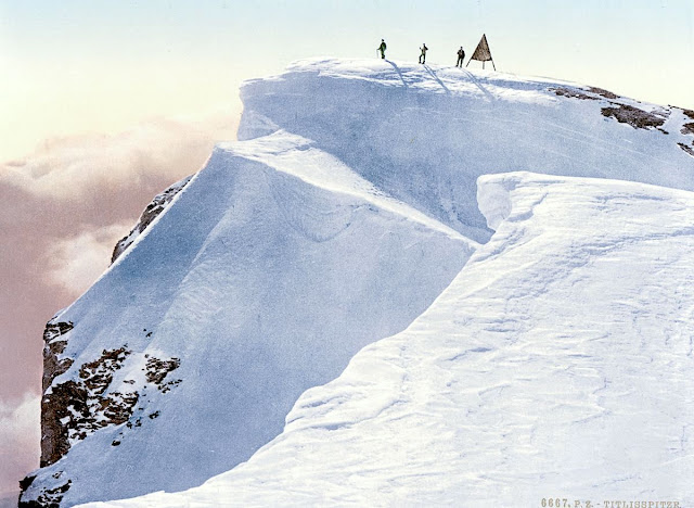
THE TITLIS IN VINTAGE POSTCARDS 1890

VINTAGE POSCARDS Titlis (3,238 m -10,623ft) Switzerland  In " Titlis Spitze, Unterwald - La Suisse en Couleur " postcard, 1890, The Library of Congress Photographs Division, Washington DC

VINTAGE POSCARDS
Titlis (3,238 m -10,623ft)
Switzerland

In " Titlis Spitze, Unterwald - La Suisse en Couleur " postcard, 1890,
The Library of Congress Photographs Division, Washington DC


The mountain
Titlis  (3,238 m - 10,623 ft) is a mountain of the Uri Alps, located on the border between the cantons of Obwalden and Bern. It is the highest summit of the range north of the Susten Pass, between the Bernese Oberland and Central Switzerland. It is mainly accessed from Engelberg (OW) on the north side and is famous as the site of the world's first rotating cable car.  The cable car system connects Engelberg (996 m (3,268 ft)) to the summit of Klein Titlis (3,028 m (9,934 ft)) through the three stages of Gerschnialp (1,262 m (4,140 ft)), Trübsee (1,796 m (5,892 ft)) and Stand (2,428 m (7,966 ft)), although somewhat recently, a newer, direct route was created that bypassed Gerachnialp, going directly to Trübsee.
The last part of cable car leads above the glacier. At Klein Titlis, it is possible to visit an illuminated glacier cave from an entrance within the cable-car station, which also includes shops and restaurants. The Titlis Cliff Walk, the highest elevation suspension bridge in Europe, opened in December 2012, giving views across the Alps. Many people use Titlis as a cheaper and easier option than Jungfraujoch.
In earlier times, Titlis was known under the names Wendenstock or Nollen. The Reissend Nollen and the Wendenstöcke are the nearest western neighbours to the mountain, slightly lower than Titlis, but with sharp rugged peaks. In a document of 1435 the mountain is called Tuttelsberg(Tutilos mountain), referencing to a man named Tutilos, who was probably a local farmer. The name, from Tutilos Berg, became Titlisberg and later Titlis.
The first ascent of Titlis was probably made in the year 1739. It was done by Ignaz Hess, J. E. Waser and two other men from Engelberg.  The first written evidence of an ascent is found in the Engelberger Dokumente. They mention a party of four men that reached the summit in 1744.
 On 21 January 1904 the first ski ascent of Titlis was made by Joseph Kuster and Willi Amrhein. In March 1967 the cable car to Klein Titlis (3,032 m) was inaugurated. In December 2012, the Titlis Cliff Walk opened to commemorate the 110th anniversary of the Engelberg-Gerschnialp cableway.


Vintage postcards
Postcards were colorized as soon as they appeared on the market at the end of 19th century ; the photos were then repainted by hand by women with very fine brushes, then a varnish was applied to fix these colors which were always very contrasting... and sometimes very far from reality!
Postcards became popular at the turn of the 20th century, especially for sending short messages to friends and relatives. They were collected right from the start, and are still sought after today by collectors of pop culture, photography, advertising, wartime memorabilia, local history, and many other categories. Postcards were an international craze, published all over the world. The Detroit Publishing Co. and Teich & Co. were two of the major publishers in the U.S, and sometimes individuals printed their own postcards as well. Yvon were the most famous in France. Many individual or anonymous publishers did exist around the world and especially in Africa and Asia (Japan, Thailand, Nepal, China, Java) between 1920 and 1955. These photographer were mostly local notables, soldiers, official guides belonging to the colonial armies (british french, belgium...) who sometimes had rather sophisticated equipment and readily produced colored photograms or explorers, navigators, climbers (Vittorio Sella and the Archiduke of Abruzzi future king of Italy remains the most famous of them).
There are many types of collectible vintage postcards.
Hold-to-light postcards were made with tissue paper surrounded by two pieces of regular paper, so light would shine through. Fold-out postcards, popular in the 1950s, had multiple postcards attached in a long strip. Real photograph postcards (RPPCs) are photographs with a postcard backing.
Novelty postcards were made using wood, aluminum, copper, and cork. Silk postcards–often embroidered over a printed image–were wrapped around cardboard and sent in see-through glassine paper envelopes; they were especially popular during World War I.
In the 1930s and 1940s, postcards were printed on brightly colored paper designed to look like linen.
Most vintage postcard collectors focus on themes, like Christmas, Halloween, portraits of movie stars, European royalty and U.S. presidents, wartime imagery, and photos of natural disasters or natural wonders. Not to mention cards featuring colorful pictures by famous artists like Alphonse Mucha, Harrison Fisher, Ellen Clapsaddle, and Frances Brundage.

__________________________________________
2022 - Wandering Vertexes...
by Francis Rousseau


Monday, July 11, 2022

DJEBEL TOUKBAL (4) PAINTED BY SIR WINSTON CHURCHILL


SIR WINSTON CHURCHILL (1874-1965) Jebel Toubkal (4,167 m - 13, 671 ft) Morocco  In Atlas mountains viewed from Marrakech, oil on canvas, 1949.

SIR WINSTON CHURCHILL (1874-1965)
Jebel Toubkal (4,167 m - 13, 671 ft)
Morocco

In Atlas mountains viewed from Marrakech, oil on canvas, 1949.


The mountain 

Jebel Toubkal (4,167 m - 13, 671 ft)  is the high point of the High Atlas as well as Morocco and North Africa . It is located 63 km south of Marrakech, in the province of Al Haouz, inside the national park that bears its name.
The word Toubkal would be a deformation of French origin of the same Amazigh name Tugg Akal or toug-akal  which means "the one who looks up the earth". The people of this region still use this name.  The Toubkal massif is made up of rocks of various natures. Dark rocks of volcanic origin are found on the summits of andesite and rhyolite. Glaciers have left characteristic marks of their passage in the form of valleys in trough. During the Würm glaciation, the present valley of Assif n'Ait Mizane  was occupied by the longest glacier in the Atlas, about 5 km long.
The climate at Jebel Toubkal  is mountainous. The snow falls in winter and covers the summit.
In the nineteenth century, the interior of Morocco was still terra incognita for the Europeans and for a long time the Jebel Ayachi (3,747 m -12,293ft) ) passed for the highest summit of the High Atlas. In fact, the Toubkal was officially climbed for the first time only on 12 June 1923 by the Marquis de Segonzac, accompanied by Vincent Berger and Hubert Dolbeau. The cairns which they found on the summit had been built by the Berbers of the environs for whom the Toubkal is a holy place dedicated to Sidi Chamarouch (or Chamharouch). A sanctuary is dedicated to him on the way from Imlil to Toubkal.
The ascent of the roof of North Africa attracts a large number of followers of the trekking. This ascent attracts the crowd as much as it does not present great technical difficulties and that the assistance of the muleteers and their mules reduces the physical efforts. The altitude is relatively high (3,200 meters at the shelter and 4,167 meters at the summit).

The artist
Winston Leonard Spencer-Churchill was forty before he discovered the pleasures of painting. The compositional challenge of depicting a landscape gave the heroic rebel in him temporary repose. He possessed the heightened perception of the genuine artist to whom no scene is commonplace. Over a period of forty-eight years his creativity yielded more than 500 pictures. His art quickly became half passion, half philosophy. He enjoyed holding forth in speech and print on the aesthetic rewards for amateur devotees. To him it was the greatest of hobbies. He had found his other world -- a respite from crowding events and pulsating politics.
Encouragement to persevere with his hobby stemmed from an amateur prize (his first) which he won for "Winter Sunshine, Chartwell" a bright reflection of his Kentish home. He sent five paintings to be exhibited in Paris in the 1920s.
Modesty shone through that self-estimate. Modesty - and warm sympathy --were undeniably evident in what Churchill told a fellow painter, Sergeant Edmund Murray, his bodyguard from 1950 to 1965. Murray had been in the Foreign Legion and the London Metropolitan Police. Interviewing him to gauge his suitability, Churchill said: "You have had a most interesting life. And I hear you even paint in oils." After Murray had his work rejected by the Royal Academy, Churchill told him: "You know, your paintings are so much better than mine, but yours are judged on their merit."
Churchill's progressive workmanship demonstrates that a pseudonym employed at a crucial stage shrewdly enabled him to find out where he stood before moving on to fine-tool his talent.Churchill again favoured a pseudonym (Mr. Winter) in 1947 when offering works to the Royal Academy, so his fame in other spheres was not exploited. Two pictures were accepted and eventually the title of Honorary Academician Extraordinary was conferred on him. He earned it. That is borne out by the conclusion of the renowned painter Sir Oswald Birley: "If Churchill had given the time to art that he has given to politics, he would have been by all odds the world's greatest painter." Connoisseurs of Sir Winston's art stoutly defend their individual preference, but there are convincing arguments for bestowing highest praise on "The Blue Sitting Room, Trent Park" which was sold in 1949 to aid charity.
Despite outward flippancy, Churchill had a true craftsman's dedication when he took up a paint brush. He consulted teachers admired for their professionalism. He was fond of citing Ruskin's Elements of Drawing and readily accepted Sir William Orpen's suggestion that he should visit Avignon, where the light can verge on a miracle. He recalled an encounter on the Côte d'Azur with artists who worshipped at the throne of Cezanne and gratefully acknowledged the inspiration he derived from their exchange. Marrakech, Morocco -- irresistible and productive -- always brought out the best in him.
Churchill sought and found tranquillity in his art. His much quoted words, summing up expectations of celestial bliss, retain their lustre: "When I get to heaven I mean to spend a considerable portion of my first million years in painting, and so get to the bottom of the subject..."
___________________________________________


2022 - Wandering Vertexes...
by Francis Rousseau
 

Tuesday, July 5, 2022

ALPAMAYO SUMMIT PHOTOGRAPHED IN 1936 BY ERWIN SCHNEIDER


ERWIN SCHNEIDER (1906-1987) Alpamayo ( 5,947m - 19,511 ft) Peru  In  "Alpamayo summit", argentic photo 1936 
 
 
ERWIN SCHNEIDER (1906-1987) 
Alpamayo ( 5,947m - 19,511 ft) 
Peru

In  "Alpamayo summit", argentic photo 1936


The mountain

Alpamayo ( 5,947m - 19,511 ft) possibly named from Quechua words is one of the most conspicuous peaks in the Cordillera Blanca of the Peruvian Andes. Alpamayo Creek originates northwest of it. The Alpamayo lies next to the slightly higher Quitaraju. n July 1966, the German magazine "Alpinismus", published a photo of Alpamayo taken by American photographer Leigh Ortenburger accompanied by an article on a survey among mountaineering experts, who chose Alpamayo as "The Most Beautiful Mountain in the World". Not defined by a single summit Alpamayo has two sharp summits, the North and south, which are separated by a narrow corniced ridge.
The first attempt on Alpamayo's summit was in 1948 by a Swiss expedition. Climbing by way of the heavily corniced North Ridge, the three climbers came within sight of the virgin summit when a large cornice broke under them and they were carried down the precipitous Northwest Face. By some amazing piece of good fortune, the three were neither buried nor injured by the 650 foot fall and they were able to make an 'orderly retreat' from the mountain. In 1951, a Franco-Belgian expedition including George and Claude Kogan claimed to have made the first ascent via the North Ridge. After studying the photos in George Kogan's book The Ascent of Alpamayo, the German team of Günter Hauser, Frieder Knauss, Bernhard Huhn and Horst Wiedmann came to the conclusion that the 1951 team did not reach the actual summit, thereby making their ascent via the South Ridge in 1957 the first. Although the South Ridge is no less steep or dangerous than the North Ridge, it has the advantage of leading directly to the higher south summit. This was written up in Hauser's book White Mountain and Tawny Plain. Although there are several climbing routes on the Southwest Face the most common is known as the Ferrari or Italian Route. It was opened in 1975 by a group of Italian alpinists led by Casimiro Ferrari. It begins at the top of the highest point of the snow slope where the bergshrund separates the upper face on the left and then ascends a steep runnel to the summit ridge. Because of its esthetic beauty, Alpamayo is one of the most climbed mountains in the Andes and the base camp can be a hodge-podge of nationalities. Each year the route is made easy by the first party to ascend the route as they usually leave snow-stakes in place at the belay stations. Then it is just a matter of finding out what length of rope they used so that your rope is long enough to reach each station. In the summer of 1988, they had used 50m ropes.

The photographer
Erwin Hermann Manfred Schneider was an Austrian mountaineer. On July 25, 1928, he was part of the German-Soviet expedition for the first ascent of Lenin Peak. They reach the top with Karl Wien and Eugen Allwein. In 1930, he participated in an expedition in the Himalayas led by Günter Dyhrenfurth to Kangchenjunga. On June 21, 1931, he made the first ascent of Jongsong Peak at 7,462 meters1,2. They climb the Ramthang Chang at 6,802 meters. In 1932 and 1936, he took part in two expeditions organized by the German-Austrian Alpine Club (DuOeAV). During these expeditions, Schneider and his companions made about ten first ascents.

___________________________________________
2022 - Wandering Vertexes...
by Francis Rousseau

Friday, June 3, 2022

NUPTSE PAINTED BY JAMES HART DYKE


JAMES HART DYKE  (bn 1966) Nuptse  (7,861 m - 25,791 ft) Nepal  In Nuptse Himalaya ,2011, Acrylic on paper-  Courtesy John Mitchell  Gallery, London


JAMES HART DYKE  (bn 1966)
Nuptse  (7,861 m - 25,791 ft)
Nepal

In Nuptse Himalaya ,2011, Acrylic on paper,  Courtesy John Mitchell  Gallery, London


The mountain
Nuptse or Nubtse is a mountain in the Khumbu region of the Mahalangur Himal, in the Nepalese Himalayas. It lies two kilometres WSW of Mount Everest. Nubtse is Tibetan for "west peak", as it is the western segment of the Lhotse-Nubtse massif.
The main peak, Nubtse I, was first climbed on May 16, 1961 by Dennis Davis and Sherpa Tashi and the following day by Chris Bonington, Les Brown, James Swallow and Pemba Sherpa, members of a British expedition led by Joe Walmsley. After a long hiatus, Nubtse again became the objective of high-standard mountaineers in the 1990s and 2000s, with important routes being put up on its west, south, and north faces. While Nubtse is a dramatic peak when viewed from the south or west, and it towers above the base camp for the standard south col route on Everest, it is not a particularly independent peak: its topographic prominence is only 319 m (1,047 ft). Hence it is not ranked on the list of highest mountains.


The painter
James Hart Dyke’s work is centred on landscape painting, from the domesticity of paintings of country houses to paintings generated from physically demanding expeditions over remote mountains. James has also undertaken a series of projects including accompanying HRH The Prince of Wales as the official artist on royal tours, working as ‘artist in residence’ for The British Secret Intelligence Service, working as an artist embedded with the British Forces in war zones, working for the producers of the James Bond films and working as ‘artist in residence’ for Aston Martin. These projects required him to respond in many different ways and have allowed him to experiment with more graphic forms of painting influenced by his studies as an architect at the Royal College of Art. His portraits have been shown at the National Portrait Gallery and at the Royal Society of Portrait Painters exhibitions.

___________________________
2022 - Wandering Vertexes
Un blog de Francis Rousseau

Saturday, May 28, 2022

MOUNT COLEMAN PAINTED BY ARTHUR P. COLEMAN

ARTHUR P. COLEMAN (1852-1939) Mount Coleman (3,135 m-10,285 ft) Canada (Alberta)
 

ARTHUR P. COLEMAN (1852-1939)
Mount Coleman (3,135 m-10,285 ft)
Canada (Alberta) 

 In  "Mountain un the Canadian rockies"

The mountain
Mount Coleman (3,135 m-10,285 ft) mountain summit located in the upper North Saskatchewan River valley in Banff National Park, in the Canadian Rockies of Alberta, Canada. Its nearest higher peak is Cirrus Mountain, 4.46 km (2.77 mi) to the north.  Mount Coleman is situated along the east side the Icefields Parkway midway between Saskatchewan Crossing and Sunwapta Pass.
Mount Coleman was named in 1898 after Arthur Philemon Coleman (1852-1939), a Canadian geologist and among the first white men to explore the area that is now Jasper National Park.(see below). Like other mountains in Banff Park, Mount Coleman is composed of sedimentary rock laid down from the Precambrian to Jurassic periods. Formed in shallow seas, this sedimentary rock was pushed east and over the top of younger rock during the Laramide orogeny.  Based on the Köppen climate classification, Mount Coleman is located in a subarctic climate with cold, snowy winters, and mild summers.  Temperatures can drop below -20 °C with wind chill factors below -30 °C. Precipitation runoff from Mount Coleman drains into tributaries of the North Saskatchewan River.

The painter
Arthur Philemon Coleman was a Canadian a geologist, professor, minerals prospector, artist, Rockies explorer, backwoods canoeist, world traveller, scientist, popular lecturer, museum administrator, memoirist and... one of Canada’s most beloved scientist.
Arthur Coleman is a fine example of that rare bird, a polished amateur artist whose drawings and paintings stand comfortably beside those of many professionals. He was active during the time when sketching and painting was ceding to photography the task of recording the visible world. Although he was also a photographer, painting was, for him, both a poetic and a descriptive pursuit, a way of wrapping an artistic expression around a phenomenon he was interested in or moved by. Thus motivated, Coleman's paintings give much joy and command a good deal of respect. The more surprising, perhaps given that he used to introduced himself more as a geologist than a painter.
Coleman travelled throughout the United States for professional conferences as well as geological field work. He visited many of the major American mountain ranges including: the American Cordillera Mountains (Washington, Oregon and California); the Sierra Nevada Mountains (California and Nevada); Yellowstone National Park (Wyoming, Montana and Idaho); and the Appalachian Mountains (eastern United States). Pleistocene glaciation had extended in Northern Europe as far south as Berlin and London and covered an area of two million square miles. Coleman also visited such countries as India, Australia, Brazil, Argentina, Scandinavia, Bolivia, New Zealand, South Africa and Uruguay. In his final years he made two expeditions to the Andes in Colombia, to mountains in Southern Mexico and to two mountains in Central America. He achieved the first ascent of Castle Mountain in 1884, and in 1907, he was the first white man to attempt to climb Mount Robson. He made a total of eight exploratory trips to the Canadian Rockies, wholly four of them looking for the mythical giants of Hooker and Brown.
From 1901 to 1922, he was a Professor of Geology at the University of Toronto and was Dean of the Faculty of Arts from 1919 to 1922. From 1931 to 1934, he was a geologist with the Department of Mines of the Government of Ontario. He was elected a Fellow of the Royal Society of Canada in 1900 and was its President in 1921. In 1929, he was appointed Honorary Vice-President of the Royal Canadian Geographical Society.
"Mount Coleman" and "Coleman Glacier" in Banff National Park is named in his honor. He was awarded the Penrose Medal in 1936.
He planned to climb "his" mountain, "Mount Coleman"'in the Albertan Rockies, and had also prepared a trip to British Guiana, but death intervened.
He was author of:
- Reports on the Economic Geology of Ontario (1903)
- Lake Ojibway; Last of the Great Glacial Lakes (1909)
- The Canadian Rockies: New and Old Trails (1911)
- Ice Ages, Recent and Ancient (1926), and was co-author of Elementary Geology (1922).
- The Last Million Years (1941) edited by George F. Kay

__________________________________________
2022 - Wandering Vertexes...
by Francis Rousseau

Sunday, May 22, 2022

LE GRAND VEYMONT SKETCHED BY JEAN-BAPTISTE NÉE


JEAN -BAPTISTE NÉE (b.1986) The  Grand Veymont (2,341m - 7,680 ft) France (Vercors)  In Vercors, hiver, paroi, gel (II), lavis, 2019, 16 x 25cm


JEAN -BAPTISTE NÉE (b.1986)
Le Grand Veymont (2,341m - 7,680 ft)
France (Vercors)

In Vercors, hiver, paroi, gel (II), lavis, 2019, 16 x 25cm


The artist
Jean-Baptiste Née, born in 1986. is a french painter, scenographer and visual artist, graduated from Arts-Décoratifs of Paris in 2012. Jean-Baptiste Née works in the mountains and high mountains, always in situ, in direct confrontation with the movements of the earth and water and wind. He gives a growing place for the action of the elements on the work in progress (rain, snow, frost, etc.). He established his "large workshop" in the Swiss Alps or in the Vercors massif - especially in winter -, as well as during long hikes in the Italian Alps. In the winter of 2018, he worked in the massifs of Wudangshan and Lushan, in China, and became interested in the Taoist notion of "Sky". Since 2016, Jean-Baptiste Née exhibits regularly in galleries in France and Switzerland. His workshop is in Montreuil, France. Exhibited in Galerie Camera
Obscura in Paris. A book was recently published about his work "Le monde nu" Éditions Hartpon.
Contact @jeanbaptiste.nee.
Jean Basptiste Née website

The mountain,
Le Grand Veymont (2,341m - 7,680 ft)( is  a mountain in the district of Gresse-en-Vercors, part of the department of Isère, France, is the highest point of the Massif du Vercors, but not the highest of the Vercors Regional Natural Park (which is the Rocher Rond at 2,453m).  It has a prominence of 1165 metres and an isolation of 26.88 kilometres. It is situated between le Pas de la Ville to the north and le Pas des Chattons to the south, and is part of the eastern edge of the high plateau of the Massif du Vercors.  It is preceded to the north by (north to south) "le Rocher de Séguret" (the Rock of Séguret, 2051 metres), "Roche Rousse" (Red Rock, 2105 metres), and "le Sommet de Pierre-Blanche" (the Summit of White Rock, 2106 metres)  and followed to the south (north to south) by Petit Veymont or Aiguillette (little Veymont or small needle, 2120 metres) and Mont Aiguille (Mount Needle, 2085 metres). Due to its location in the Parc du Vercors, it is far from any paved road. A moderately easy route to the summit involves walking about 10 km, hiking through the backcountry.
On 10 February 2007, a twin-engine light aircraft flying from London to Cannes disappeared in a snowstorm over le Grand Veymont, crashing into the mountainside and killing all three people aboard. The bodies and wreckage were recovered less than 24 hours later, at around 1960 metres above sea level, close to the Pas de la Ville, after a rescue operation involving more than one hundred policemen, firemen, mountain rescue specialists, and three helicopters equipped with infra-red cameras.

Thursday, May 19, 2022

CERRO ACONCAGUA PAINTED BY RHOD WULFARS


RHOD WULFARS (bn. 1979) Aconcagua (6,961 m -22,838 ft) Argentina  In "Aconcagua," Acrylic on canvas, 18 x 24cm

RHOD WULFARS (bn. 1979)
Aconcagua (6,961 m -22,838 ft)
Argentina

In "Aconcagua," Acrylic on canvas, 18 x 24cm


The artist
Rhod Wulfars is a contemporary mountain painter using mainly acrylic technique for his paintings.
He was born in 1979 in Mendoza (Argentina). In his website he wrote: "I have spent my whole life by the mountains. On day I started to paint them". Using, in the manner of Nicolas de Staël, a style always beetween abstract and figurative, his very strong and very moving paintings described perfectly the majesty and the spectacular contents of the peaks he paints. Rhod Wulfars makes a surprising use of acrylic medium, in thick paste as one could do with oil paint. He used to named his works only bu numbers, and series letters, but sometime he writes the name of the peaks ans makes it more easy to identify.
Other works by this artist on his website : rhodwulfars.wixsite.com/rhodwulfars/
Contact : @rhodwulfars


The mountain
Cerro Aconcagua (6,961 meters -22,838 ft) or simplynThe Aconcagua is the highest mountain outside of Asia and by extension the highest point in both the Western Hemisphere and the Southern Hemisphere.
Aconcagua is not a volcano.  he origin of the name is contested; it is either from the Mapuche "Aconca-Hue", which refers to the Aconcagua River, the Quechua "Ackon Cahuak", meaning "Sentinel of Stone", or Quechua "Anco Cahuac", meaning "White Sentinel" or the Aymara "Janq'u Q'awa" meaning "White Ravine", "White Brook".
Aconcagua is located in the Andes mountain range, in the Mendoza Province, Argentina, and lies 112 kilometers (70 mi) northwest of its capital, the city of Mendoza and 108 km (67 mi) from Santiago de Chile (the capital of Chile). The summit is in fact located about 5 kilometers from San Juan Province and 15 kilometers from the international border with Chile; its nearest higher neighbor is Tirich Mir in the Hindu Kush, 16,520 kilometers (10,270 mi) away.
Aconcagua is one of the Seven Summit, which includes the highest mountains of each of the seven continents. The 7 summits (which are obviously 8 !)... are : Mt Everest (8,848m), Mt Denali or Mc Kinley (6,194m), Kilimandjaro (5,895m), Mt Elbrus (5,642m), Vinson Massif (4,892m), Mt Blanc (4,807m) and Mount Kosciuszko (2,228m). Summiting all of them is regarded as a mountaineering challenge, first achieved on April 30, 1985 by Richard Bass.
The mountain and its surroundings are part of the Aconcagua Provincial Park. The mountain has a number of glaciers. The largest glacier is the Ventisquero Horcones Inferior at about 10 km long, which descends from the south face to about 3600 m altitude near the Confluencia camp. Two other large glacier systems are the Ventisquero de las Vacas Sur and Glaciar Este/Ventisquero Relinchos system at about 5 km. 

___________________________

2022 - Wandering Vertexes...
by Francis Rousseau


Friday, May 13, 2022

ALEXANDRA PEAK AND MARGHERITA PEAK BY VITTORIO SELLA


VITTORIO SELLA (1859-1943) Alexandra Peak / Mount Stanley (5,091m - 16,703 ft) Congo - Uganda border    In Alexandra peak and Margherita peak from the Stanley Plateau, photo, 1906


VITTORIO SELLA (1859-1943)
Alexandra Peak / Mount Stanley (5, 091m - 16,703 ft)
Margherita Peak / mount stanley (5,109 m-16,763 ft)
Congo - Uganda border

  In Alexandra peak  and Margherita peak from the Stanley Plateau, photo, 1906


The mountain
Alexandra Peak (5,091m - 16,703ft) is part of Mount Stanley located in the Rwenzori range, the highest mountain of both Democratic Republic of the Congo and Uganda, and the third highest in Africa, after Mount Kilimanjaro (5,895 m -19,340ft) and Mount Kenya (5,199 m - 17,057ft).
Mount Stanley consists of two twin summits and several lower peaks which are :
Margherita Peak (5,109m - 16,763ft), Alexandra Peak (5,091m - 16,703ft), Albert Peak (5,087m - 16,690ft), Savoia Peak (4,977m - 16,330ft), Ellena Peak (4,968m -16,300ft), Elizabeth Peak (4,929m - 16,170 ft), Phillip Peak (4,920m - 16,140ft), Moebius Peak (4,916m - 16,130 ft) and Great Tooth (4,603m - 15,100ft).
The peak and several other surrounding peaks are high enough to support glaciers. Mount Stanley is named for the journalist and explorer, Sir Henry Morton Stanley. It is part of the Rwenzori Mountains National Park, a UNESCO world Heritage Site.
Mt. Stanley was first climbed in 1906 by the Prince Luigi Amedeo di Savoia , Duke of the Abruzzi, (1873-1933), J. Petigax, C. Ollier, and J. Brocherel. He is known as well for his Arctic explorations and for his mountaineering expeditions, particularly to Mount Saint Elias (Alaska–Yukon) and K2 (Pakistan–China). Margherita Peak is named after Queen Margherita of Italy the prince's cousin.
The Rwenzori Mountains National Park is considered a model for integration of cultural values into the Protected Area Management framework as an innovative approach to resource management, the first of its kind in Africa. As a result the local communities have embraced collaborative resource management initiatives. Given its significance as one of the biodiversity hotspots in the Albertine Rift, various local and international NGOs have supported the management and conservation of the property. A General Management Plan guides management operations on-site. Key challenges to address include illegal felling of trees, snow recession due to global warming, human population pressure adjacent to the property and management of waste generated through tourism operations. UWA is addressing the above threats through resource protection, community conservation education, research and ranger-based monitoring, ecotourism and transboundary initiatives with the DRC. The long-term maintenance of the integrity of the property will be achieved through sustainable financing, ecological monitoring, continued collaboration with key stakeholders and regional cooperation.

The artist
Vittorio Sella is a mountain italian climber and photographer who took his passion for mountains from his uncle, Quintino Sella, founder of the Italian Alpine Club. He accomplished many remarkable climbs in the Alps, the first wintering in the Matterhorn and Mount Rose (1882) and the first winter crossing of Mont Blanc (1888) and Les Rouies (1900).
He took part in various expeditions outside Italy:
- Three in the Caucasus in 1889, 1890 and 1896 where a summit still bears his name;
- The ascent of Mount Saint Elias in Alaska in 1897;
- Sikkim and Nepal in 1899;
- Possibly climb Mount Stanley in Uganda in 1906 during an expedition to the Rwenzori;
- Recognition at K2 in 1909;
- In Morocco in 1925.
During expeditions in Alaska, Uganda and Karakoram, he accompanied the Duke of Abruzzi, Prince Luigi Amedeo di Savoia.
Sella continues the practice of climbing into his old age, completing his final attempt in the Matterhorn at the age of 76; a climb he had to interrupt the rise following an accident in which one of his guides injured. He died in his hometown during World War II. His photographic collection is now managed by the Sella Foundation.
His photos mountain are still considered today to be among the finest ever made.
Jim Curran believes that "Sella remains probably the greatest photographer of the mountain. His name is synonymous with technical perfection and aesthetic refinement. "
The quality of the pictures of Vittorio Sella is partly explained by the use of a view camera 30 × 40 cm, despite the difficulty of the transportation of such a device, both heavy and fragile in places inaccessible; to be able to transport it safely, he had to make special pieces that can be stored in saddle bags. His photographs have been widely distributed, either through the press or in the galleries, and were unanimously celebrated; Ansel Adams, who was able to admire thirty-one in an exhibition that was organized at Sella American Sierra Club, said they inspired him "a religious kind of sense of wonder." Many of his pictures were taken in the mountains for the very first time in the History, which give them a much artistic, historical but also scientific value ; for example, one could measure the decline in the Rwenzori glaciers in Central Africa.
___________________________

2022 - Wandering Vertexes...
by Francis Rousseau

Saturday, May 7, 2022

MOUNT DAMAVAND / دماوند SKETCHED BY HUSAYN WA'IZ KASHIFI


HUSAYN VAIZ KASHIFI  i(died 1504-1505) Mount Damavand (5, 610m -18,410ft) Iran  In The Anvār-i Suhaylī or Lights of Canopus, 1847, The Walters Art Museum


HUSAYN WA'IZ KASHIFI (840 /1436 - 910/ 1505)
Mount Damavand   (6,105m-18,410ft)
Iran

In The Anvār-i Suhaylī or Lights of Canopus, The Walters Art Museum, Baltimore


About this work
Walters Art Museum manuscript W.599 is an illuminated and illustrated copy of Anvar-i Suhayli (The lights of Canopus), dating to the 13th century AH/AD 19thand attributed to Husayn  Kashifi
It is a Persian version of Kalilah wa-Dimnah (The fables of Bidpay). It was completed on 26 Jumadá I 1264 AH/AD 1847 by Mirza Rahim. The text is written in Nasta'liq script in black and red ink, revealing the influence of Shikastah script. There are 123 paintings illustrating the text. The Qajar binding is original to the manuscript.

The mountain
Mount Damāvand (5, 610m -18,410ft), in Persian دماوند‎‎ , a potentially active volcano, is a stratovolcano which is the highest peak in Iran and the Middle East as well as the highest volcano in Asia (the Kunlun Volcanic Group in Tibet has a higher elevation than Damāvand, but are not considered to be volcanic mountains). It has a special place in Persian mythology and folklore.The origins and meaning of the word "Damavand" is unclear, yet some prominent researchers have speculated that it probably means "The mountain from which smoke and ash arises", alluding to the volcanic nature of the mountain.
This peak is located in the middle of the Alborz range, adjacent to Varārū, Sesang, Gol-e Zard, and Mīānrūd. The mountain is located near the southern coast of the Caspian Sea, in Amol County, Mazandaran Province, 66 kilometres (41 miles) northeast of the city of Tehran. Mount Damāvand is the 12th most prominent peak in the world, and the second most prominent in Asia after Mount Everest. It is the highest volcanic mountain in Asia, and part of the Volcanic Seven Summits mountaineering challenge. Damavand is a significant mountain in Persian mythology. It is the symbol of Iranian resistance against despotism and foreign rule in Persian poetry and literature. In Zoroastrian texts and mythology, the three-headed dragon Aži Dahāka was chained within Mount Damāvand, there to remain until the end of the world. In a later version of the same legend, the tyrant Zahhāk was also chained in a cave somewhere in Mount Damāvand after being defeated by Kāveh and Fereydūn. Persian poet Ferdowsi depicts this event in his masterpiece, the Shahnameh, in which the mountain is said to hold magical powers. Damāvand has also been named in the Iranian legend of Arash (as recounted by Bal'ami) as the location from which the hero shot his magical arrow to mark the border of Iran, during the border dispute between Iran and Turan. The famous poem Damāvand by Mohammad Taqī Bahār is also one fine example of the mountain's significance in Persian literature.
Mount Damavand is depicted on the reverse of the Iranian 10,000 rials banknote.
An anthropologist of Mazandaran Cultural Heritage and Tourism Department, Touba Osanlou, has said that a proposal has been put forward by a group of Iranian mountaineers to register the highest peak in the Middle East, Mount Damavand as a national heritage site. Mazandaran Cultural Heritage and Tourism Department has accepted the proposal, the Persian daily Jam-e Jam reported.

The artist
Kamāl al-Dīn Ḥusayn ibn Alī Kashifi, best simply known as Husayn Kashifi, was a prolific Persia] prose-stylist, a poet, a Quran exegete, a Sufi scholar, and an astronomer of the Timurid era. Kashifi was his pen name, whereas his surname al-Wāʿiẓ ("the preacher") denoted his professional occupation. He spent most of his career in Herat, where his academic activities were supported by Ali-Shir Nava'i, a senior vizier in the Timurid court during Sultan Husayn Bayqara's rule, hence the reason for Kashifi to dedicate most of his works to Nava'i. He was also very close to the famous Persian poet and Sufi, Nur al-Din 'Abd al-Rahman Jami. His famous works include Akhlaq-e Mohseni and Anwar-e Sohaili  (above) in Persian prose, and Jawaher al-Tafsir and Mawaheb-e 'Aliyya which are Persian tafsirs of the Quran.

_______________________________________

2022 - Wandering Vertexes...
by Francis Rousseau