google.com, pub-0288379932320714, DIRECT, f08c47fec0942fa0 GRAVIR LES MONTAGNES... EN PEINTURE: April 2022

Friday, April 29, 2022

MOUNT VESUVIUS SEEN FROM SORRENTE BY ALFRED DE CURZON


ALFRED DE CURZON (1820-1895) Mount Vesuvius (1,281 m- 4,203 ft at present) Italy  In "Sorrente, devant la mer de Naples ", 1851 Huile sur papier marouflé sur toile 24,5 x 33 cm, Collection privée, courtesy Galerie d'Athènes, Paris


ALFRED DE CURZON (1820-1895)
Mount Vesuvius (1,281 m- 4,203 ft at present)
Italy

In "Sorrente, devant la mer de Naples ", 1851, huile sur papier marouflé sur toile 24,5 x 33 cm,
Collection privée, courtesy Galerie d'Athènes, Paris

The painter
Alfred de Curzon is a French painter, grandson of Joseph-Emmanuel-Auguste-François de Lambertye and brother of Emmanuel Parent de Curzon. Alfred de Curzon's family is part of the aristocracy of western France. While he was a student, the painting Médée furieuse by Eugène Delacroix, exhibited at the Salon of 1838, made a strong impression on him. He tries his hand at pastel and decides to become a painter. He entered the 1 April 1840 at the School of Fine Arts in Paris in the studio of Michel Martin Drolling. On the advice of one of his classmates from the school, Louis Georges Brillouin (1817-1893), he changed studio to follow the lessons of Louis Cabat from 1845.
In 1849 he painted La Mort de Milon de Crotone. At the request of the Academy, he obtained from the minister the enjoyment of the pension of Rome for two years. There he met Alexandre Cabanel, Jean-Achille Benouville, François-Léon Benouville, Louis Français and Charles Busson who remained his friend. He travel to Greece in 1852 with the writer Edmond About and the architect Charles Garnier. Greek antiquity then strongly impregnated him and is found in many of his paintings.
He began at the Salon of 1843 with a painting entitled Landscape. He obtained a 2nd class medal in 1857, followed by recalls in 1859, 1861 and 1863. He was awarded a 3rd class medal at the Universal Exhibition of 1867.
Charles Baudelaire notes, in his Salon of 1845: "A serenade in a boat, - is one of the most distinguished things of the Salon. - The arrangement of all these figures is very happily conceived; the old man at the end of the boat, lying in the middle of the garlands, is a very pretty idea. - The compositions of M. Brillouin and that of M. Curzon have some analogy; they have this above all in common, that they are well drawn - and drawn with spirit."
Alfred de Curzon practiced all genres, but it was his landscapes that made him famous. Many drawings can be seen at the Sainte-Croix museum in Poitiers (France).

The mountain 
Mount Vesuvius (1,281 m- 4,203 ft at present) is one of those legendary and mythic mountains  the Earth  paid regularly tribute. Monte Vesuvio in Italian modern langage or Mons Vesuvius in antique Latin langage is a stratovolcano in the Gulf of Naples (Italy) about 9 km (5.6 mi) east of Naples and a short distance from the shore. 
It is one of several volcanoes which form the Campanian volcanic arc. Vesuvius consists of a large cone partially encircled by the steep rim of a summit caldera caused by the collapse of an earlier and originally much higher structure.
Mount Vesuvius is best known for its eruption in AD 79 that led to the burying and destruction of the Roman antique cities of Pompeii, Herculaneum, and several other settlements. That eruption ejected a cloud of stones, ash, and fumes to a height of 33 km (20.5 mi), spewing molten rock and pulverized pumice at the rate of 1.5 million tons per second, ultimately releasing a hundred thousand times the thermal energy released by the Hiroshima bombing. At least 1,000 people died in the eruption. The only surviving eyewitness account of the event consists of two letters by Pliny the Younger to the historian Tacitus.
Vesuvius has erupted many times since and is the only volcano on the European mainland to have erupted within the last hundred years. Nowadays, it is regarded as one of the most dangerous volcanoes in the world because of the population of 3,000,000 people living nearby and its tendency towards explosive eruptions (said Plinian eruptions). It is the most densely populated volcanic region in the world.
Vesuvius was formed as a result of the collision of two tectonic plates, the African and the Eurasian. The former was subducted beneath the latter, deeper into the earth. As the water-saturated sediments of the oceanic African plate were pushed to hotter depths in the earth, the water boiled off and caused the melting point of the upper mantle to drop enough to create partial melting of the rocks. Because magma is less dense than the solid rock around it, it was pushed upward. Finding a weak place at the Earth's surface it broke through, producing the volcano.
he area around Vesuvius was officially declared a national park on June 5, 1995. The summit of Vesuvius is open to visitors and there is a small network of paths around the mountain that are maintained by the park authorities on weekends.
There is access by road to within 200 metres (660 ft) of the summit (measured vertically), but thereafter access is on foot only. There is a spiral walkway around the mountain from the road to the crater.
The first funicular cable car on Mount Vesuvius opened in 1880. It was later destroyed by the 1944 eruption. "Funiculì, Funiculà", a famous Neapolitan song with lyrics by journalist Peppino Turco set to music by composer Luigi Denza, commemorates its opening.
 
_______________________________

2022 - Wandering Vertexes / Mountain painting
By Francis Rousseau

Tuesday, April 26, 2022

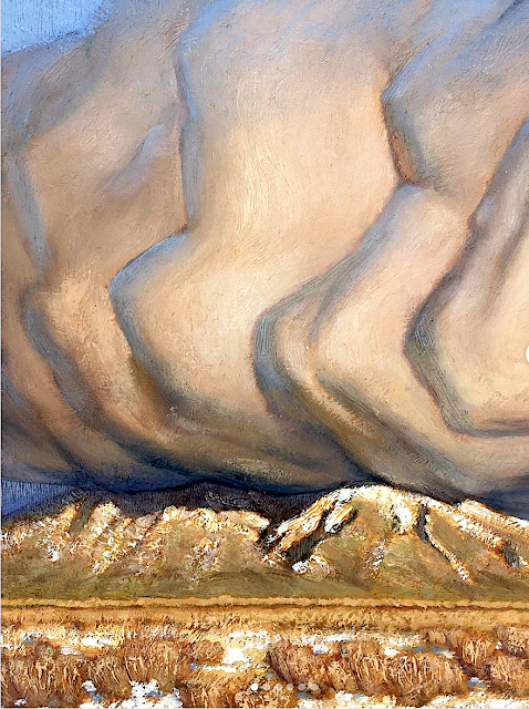
TAOS MOUNTAINS (PICURIS) PAINTED BY NATHANAEL VOLCKENING


NATHANAEL VOLKENING  Picuris Mountains (2,967 m - 9,734 ft) United States of America (New Mexico) In Winer bloom, oil on silk, 14 x 11cm, Taos Studio Society.


NATHANAEL VOLKENING
Picuris Mountains (2,967 m - 9,734 ft)
United States of America (New Mexico)

In Winer bloom, oil on silk, 14 x 11cm, Taos Studio Society.


The mountains
Picuris Mountains (2,967 m - 9,734 feet) is one of the Ridge in Taos County, nearby Osha Canyon and Vallecitos. Named Pikuria – those who paint – by Spanish colonizer Juan de Oñate, Picuris is located 24 miles (38 km) southeast of Taos in the Sangre de Cristo Mountains via N.M. 68, 518, and 75. Picuris, once the largest, today is one of the smallest Tiwa pueblos, with some 1,801 inhabitants (Census 2000). Like Taos, it was influenced by Plains Indian culture, particularly the Apaches
If one like biking, the ride takes you into the scenic and historic part of Picuris Mountains. About 2 miles from the start of this ride you will cross the historic Camino Real, or “Royal Highway,” that served as the original highway to Taos for traders, settlers, and Native Americans traveling north and south for several hundred years.
In late spring through fall this ride is free of snow and dry. It can be pretty beastly pushing up this mountain in the middle of summer. Plan on riding early or late in the day to avoid the heat.

_______________________________

2022 - Wandering Vertexes / Mountain paintings
By Francis Rousseau

Saturday, April 23, 2022

THE MONT BLANC PAINTED BY CESARE MAGGI


CESARE MAGGI (1881-1962), The Mont Blanc (4,808.73 m -15,777 ft) France - Italy  In " Alla montagne, il Monte Biancho", fuile sur toile, détail.

CESARE MAGGI (1881-1962),
The Mont Blanc (4,808.73 m -15,777 ft)
France - Italy

In " Alla montagne, il Monte Biancho", oil on canvas 


The painter
The italian painter Cesare Maggi was born into a family of actors, Maggi embarked on classical studies at his father’s wish but also took up painting at a very early age His debut in Florence at the Esposizione Annuale della Società di Belle Arti di Firenze in 1898 was followed by a short trip to Paris to catch up with the latest developments.
The crucial turning point in Maggi’s art came in 1889 with the posthumous show of work by Giovanni Segantini held by the Milanese Society of Fine Arts, which prompted a definitive shift to landscape painting of a Divisionist character. After a short stay in the Engadin, he returned to Milan before finally settling in Turin. Commercial collaboration with Alberto Grubicy until 1913 enabled Maggi to establish himself quickly as one of the leading representatives of the second generation of Divisionist painters in Italy. He painted a repertoire of readily comprehensible mountain landscapes focusing primarily on aspects of the visual perception of the reflection of light and colour but lacking the deep spirituality of Segantini’s work. He took part in the major Italian and European exhibitions and the Venice Biennale devoted an entire room to his work at the Esposizione Internazionale d’Arte of Venice in 1912. After an interlude devoted to portrait painting in the same decade, the artist’s mature work focused on greater simplification of subject matter, mostly in landscapes.
Maggi obtained the chair in painting at the Albertina Academy, Turin, in 1936.


The mountain

The Mont-Blanc (in French) (4 ,808.73 m -15,777 ft) or Monte Bianco (in Italian), both meaning "White Mountain", is the highest mountain in the Alps and the highest in Europe after the Caucasus peaks. It is ranked 11th in the world in topographic prominence. The Mont Blanc is one of the Seven Summit, which includes the highest mountains of each of the seven continents. Summiting all of them is regarded as a mountaineering challenge, first achieved on April 30, 1985 by Richard Bass. The 7 highest summit, (which are obviously 8 with 2 in Europe !) are : Mount Everest (8,848m), Aconcagua (6,961m), Mt Denali or Mc Kinley (6,194m), Kilimandjaro (5,895m), Mt Elbrus (5,642m), Mount Vinson (4,892m) and Mount Kosciuszko (2,228m) in Australia.
The mountain lies in a range called the Graian Alps, between the regions of Aosta Valley, Italy, and Savoie and Haute-Savoie, France. The location of the summit is on the watershed line between the valleys of Ferret and Veny in Italy and the valleys of Montjoie, and Arve in France. The Mont Blanc massif is popular for mountaineering, hiking, skiing, and snowboarding.
The three towns and their communes which surround Mont Blanc are Courmayeur in Aosta Valley, Italy, and Saint-Gervais-les-Bains and Chamonix in Haute-Savoie, France. A cable car ascends and crosses the mountain range from Courmayeur to Chamonix, through the Col du Géant. Constructed beginning in 1957 and completed in 1965, the 11.6 km (7¼ mi) Mont Blanc Tunnel runs beneath the mountain between these two countries and is one of the major trans-Alpine transport routes.
Since the French Revolution, the issue of the ownership of the summit has been debated.
From 1416 to 1792, the entire mountain was within the Duchy of Savoy. In 1723 the Duke of Savoy, Victor Amadeus II, acquired the Kingdom of Sardinia. The resulting state of Sardinia was to become preeminent in the Italian unification.[ In September 1792, the French revolutionary Army of the Alps under Anne-Pierre de Montesquiou-Fézensac seized Savoy without much resistance and created a department of the Mont-Blanc. In a treaty of 15 May 1796, Victor Amadeus III of Sardinia was forced to cede Savoy and Nice to France. In article 4 of this treaty it says: "The border between the Sardinian kingdom and the departments of the French Republic will be established on a line determined by the most advanced points on the Piedmont side, of the summits, peaks of mountains and other locations subsequently mentioned, as well as the intermediary peaks, knowing: starting from the point where the borders of Faucigny, the Duchy of Aoust and the Valais, to the extremity of the glaciers or Monts-Maudits: first the peaks or plateaus of the Alps, to the rising edge of the Col-Mayor". This act further states that the border should be visible from the town of Chamonix and Courmayeur. However, neither the peak of the Mont Blanc is visible from Courmayeur nor the peak of the Mont Blanc de Courmayeur is visible from Chamonix because part of the mountains lower down obscure them. A Sardinian Atlas map of 1869 showing the summit lying two thirds in Italy and one third in France.
After the Napoleonic Wars, the Congress of Vienna restored the King of Sardinia in Savoy, Nice and Piedmont, his traditional territories, overruling the 1796 Treaty of Paris. Forty-five years later, after the Second Italian War of Independence, it was replaced by a new legal act. This act was signed in Turin on 24 March 1860 by Napoleon III and Victor Emmanuel II of Savoy, and deals with the annexation of Savoy (following the French neutrality for the plebiscites held in Tuscany and Emilia-Romagna to join the Kingdom of Sardinia, against the Pope's will). A demarcation agreement, signed on 7 March 1861, defines the new border. With the formation of Italy, for the first time Mont Blanc is located on the border of France and Italy.
The 1860 act and attached maps are still legally valid for both the French and Italian governments. One of the prints from the 1823 Sarde Atlas positions the border exactly on the summit edge of the mountain (and measures it to be 4,804 m (15,761 ft) high). The convention of 7 March 1861 recognises this through an attached map, taking into consideration the limits of the massif, and drawing the border on the icecap of Mont Blanc, making it both French and Italian.Watershed analysis of modern topographic mapping not only places the main summit on the border, but also suggests that the border should follow a line northwards from the main summit towards Mont Maudit, leaving the southeast ridge to Mont Blanc de Courmayeur wholly within Italy.
Although the Franco-Italian border was redefined in both 1947 and 1963, the commission made up of both Italians and French ignored the Mont Blanc issue. In the early 21st century, administration of the mountain is shared between the Italian town of Courmayeur and the French town of Saint-Gervais-les-Bains, although the larger part of the mountain lies within the commune of the latter.

___________________________________________
2022- Wandering Vertexes...
by Francis Rousseau

Wednesday, April 20, 2022

LE ROCHER DES DEUX TROUS PAINTED BY VINCENT VAN GOGH


VINCENT VAN GOGH (1853-1890) Le Rocher des Deux Trous (348m - France (Provence)


VINCENT VAN GOGH (1853-1890)
Le Rocher des Deux Trous (348m - 1,141 ft)
France (Provence)


The hill
The Rocher des Deux Trous (348m) in the Alpilles massif is one of the most popular hikes for walkers, satrting from Saint-Remy de Provence. It offers a 360° panorama over the two slopes of the Alpilles and over the entire surrounding region, from Mont Ventoux to the north and as far as the Mediterranean Sea to the south, on a clear day. This picturesque rock eroded and sculpted by the North wind (the Mistral) was painted by Van Gogh during his stay in Saint-Paul de Mausole from May 1889 to May 1890.

The painter
Vincent Willem van Gogh was a Dutch Post-Impressionist painter who is among the most famous and influential figures in the history of Western art. In just over a decade he created about 2100 artworks, including around 860 oil paintings, most of them in the last two years of his life. They include landscapes, still lifes, portraits and self-portraits, and are characterized by bold, symbolic colours, and dramatic, impulsive and expressive brushwork that contributed to the foundations of modern art. He died by suicide at 37, following years of mental illness and poverty.
Born into an upper-middle-class family, Van Gogh drew as a child and was serious, quiet and thoughtful. As a young man he worked as an art dealer, often travelling, but became depressed after he was transferred to London. He turned to religion, and spent time as a missionary in southern Belgium. Later he drifted in ill health and solitude. He took up painting in 1881 having moved back home with his parents. His younger brother Theo supported him financially, and the two kept up a long correspondence by letter.
More about Vincent Van Gogh

_______________________________

2022 - Wandering Vertexes...
by Francis Rousseau

Sunday, April 17, 2022

GULA MONS (ON VENUS) BY NASA MAGELLAN MISSION


NASA MAGELLAN MISSION (1989-1994) Gula Mons (3000m/3km -9,843ft/1.9mi) Planet Venus (Solar system /The Milky Way Galaxy)

NASA MAGELLAN MISSION (1989-1994)
Gula Mons (3000m/3km -9,843ft/1.9mi)
Planet Venus (Solar system /The Milky Way Galaxy)


The mountain
Gula Mons (3000m/3km -9,843ft/1.9mi high and 276km diameter), named after the Mesopotamian Goddess of Healing, is a shield volcano on planet Venus in western Eistla Regio, located south of Sedna Planitia, west of Bereghinya Planitia and east of Guinervere Planitia, at 21,9° N et 359,1° E.
Its main feature is a NE-SW-oriented rift-like fracture set connecting two summit calderas. There is also a structure which links the northern caldera and ridge system to Idem Kuva corona located NW of Gula Mons. Radially spreading lava flows which have digitate and broad sheet-like forms extend from the summit, including radar-dark flows which overlay several older lava deposits. Radial and circumferential fractures are present on the flanks.

The image capturer
Gula Mons is displayed in this computer-simulated view of the surface of Venus. The viewpoint is located 110 kilometers (68 miles) southwest of Gula Mons at the same elevation as the summit, 3 kilometers (1.9 miles) above Eistla Regio. Lava flows extend for hundreds of kilometers across the fractured plains. The view is to the northeast with Gula Mons appearing at the center of the image. Gula Mons, a 3 kilometer (1.9 mile) high volcano, is located at approximately 22 degrees north latitude, 359 degrees east longitude in western Eistla Regio. Magellan synthetic aperture radar data is combined with radar altimetry to produce a three-dimensional map of the surface. Rays cast in a computer intersect the surface to create a three-dimensional perspective view. Simulated color and a digital elevation map developed by the U.S. Geological Survey are used to enhance small-scale structure. The simulated hues are based on color images recorded by the Soviet Venera 13 and 14 spacecraft. The image was produced by the JPL Multimission Image Processing Laboratory and is a single frame from a video released at the March 5, 1991, JPL news conference.  
- More about NASA Magellan Mission 

 
___________________________________________
2022 - Wandering Vertexes...
by Francis Rousseau

Friday, April 15, 2022

NAANU-I-CAKE PAINTED BY CONSTANCE GORDON-CUMMING (1837–1924)


CONSTANCE GORDON-CUMMING (1837–1924) Naanu-i-Cake (no elevation data) Fiji

CONSTANCE GORDON-CUMMING (1837–1924)
Naanu-i-Cake (no elevation data)
Fiji

In "Nananu, Fiji ", watercolor 28.5 x 42 cm

The volcano
Naanu-i-Cake  (no elevation data) is a volcanic island in Fiji less than one kilometer off the coast of the main island of Viti Levu, near the Rakiraki-district in Ra Province. Nananu-i-Cake is located immediately next to the island of Nananu-i-Ra. Nananu-i-Cake and Mabua (the islet located immediately to the southeast) islands are about 600 acres (242.81 hectares) in area. The main residence on the island was designed by the architecture firm of Murray Cockburn, based in Auckland.  A deep-water jetty is on the island's western shore.  In 1974, Sir Harold Mitchell visited Fiji from the UK and purchased Nananu-i-Cake and Mabua as a retreat. Because of Harold's position of Vice-Chairman of the Conservative Party under Sir Winston Churchill and his social and political standing, several high-profile dignitaries visited and stayed on the island. Commemorative trees were planted for many of these high-profile visits. Nananu-i-Cake has remained in Sir Harold Mitchell's family since 1974.  Nananu-i-Cake also retains evidence of moka, stone formations built in tidal areas to trap fish at low tide, and ring-wall fortifications built with volcanic rocks. As of 2012, the entire island is tentatively available for sale as a private island, for an estimated equivalent of around $8-8.5 million USD. In early 2022 the island received renewed attention on social media as self-proclaimed crypto-enthustiasts Max Olivier and Helena López Jurado announced plans to purchase the Nananu-i-Cake and build a private resort aimed at other crypto-enthusiasts using money raised from selling NFTs tied to property on the island to prospective residents.

The painter
Constance Frederica “Eka” Gordon-Cumming was a noted Scottish travel writer and painter. Born in a wealthy family, she travelled around the world and painted described scenes and life as she saw them.
Constance Gordon-Cumming was a prolific landscape painter, mostly in Asia and the Pacific. She painted over a thousand watercolors and worked with a motto to ‘never a day without at least one careful-coloured sketch’ starting her day at 5 am while in India. Places she visited include Australia, New Zealand, America, China, and Japan.
She arrived in Hilo, Hawaii in October 1879, and was among the first artists to paint the active volcanoes. Her Hawaii travelogue, Fire Fountains: The Kingdom of Hawaii, was published in Edinburgh in 1883. She had several dangerous moments but her travel ended in 1880 when the Montana that she was on ran into rocks at Holyhead. While most of the passengers took the lifeboat, she stayed on last along with the captain to save her paintings and was rescued many hours later. She returned to live at Crieff with her widowed sister Eleanor and continued to write books.
Her best known books are At Home in Fiji and A Lady's Cruise on a French Man-of-War. The latter book resulted from an invitation to join a French ship put into service for the Bishop of Samoa so that he could visit remote parts of his far-flung diocese.
Miss Gordon-Cumming received much criticism from male writers of the era, perhaps because she did not fit in the traditional Victorian role of women, as she often traveled alone and unaided.
In any case, her landscape drawings and watercolors seem to be universally admired.

___________________________________________
2022 - Wandering Vertexes...
by Francis Rousseau

Tuesday, April 12, 2022

MOUNT TARANAKI / EGMONT SKETCHED BY GEORGINA BURNE HETLEY


GEORGINA BURNE HETLEY (1832-1898) Mount Taranaki/ Mount Egmont (2,518 m - 8,261 ft) New Zealand (North Island)


GEORGINA BURNE HETLEY (1832-1898)
Mount Taranaki/ Mount Egmont (2,518 m - 8,261 ft)
New Zealand (North Island)

In "New Plymouth and Mt Taranaki/Egmont in background ", ink and watercolor,
Alexander Turnbull LIbrary.


The mountain
Taranaki or Mount Egmont (2,518 m - 8,261 ft is an active but quiescent stratovolcano in the Taranaki region on the west coast of New Zealand's North Island. Although the mountain is more commonly referred to as Taranaki, it has two official names under the alternative names policy of the New Zealand Geographic Board. The mountain is one of the most symmetrical volcanic cones in the world. There is a secondary cone, Fanthams Peak or Panitahi in Māori (1,966 m - 6,450 ft), on the south side. Because of its resemblance to Mount Fuji, Taranaki provided the backdrop for the movie The Last Samurai.
For many centuries the mountain was called Taranaki by Māori. The Māori word tara means mountain peak, and naki is thought to come from ngaki, meaning "shining", a reference to the snow-clad winter nature of the upper slopes. It was also named Pukehaupapa and Pukeonaki by Iwi who live in the region in ancient times.
According to Māori mythology, Taranaki once resided in the middle of the North Island, with all the other New Zealand volcanoes. The beautiful Pihanga was coveted by all the mountains, and a great battle broke out between them. Tongariro eventually won the day, inflicted great wounds on the side of Taranaki, and causing him to flee. Taranaki headed westwards, following Te Toka a Rahotu and forming the deep gorges of the Whanganui River, paused for a while, creating the depression that formed the Te Ngaere swamp, then heading north. Further progress was blocked by the Pouakai ranges, and as the sun came up Taranaki became petrified in his current location. When Taranaki conceals himself with rainclouds, he is said to be crying for his lost love, and during spectacular sunsets, he is said to be displaying himself to her. In turn, Tongariro's eruptions are said to be a warning to Taranaki not to return.
Captain Cook named it Mount Egmont on 11 January 1770 after John Perceval, 2nd Earl of Egmont, a former First Lord of the Admiralty who had supported the concept of an oceanic search for Terra Australis Incognita. Cook described it as "of a prodigious height and its top cover'd with everlasting snow" surrounded by a "flat country ... which afforded a very good aspect, being clothed with wood and verdure".
When Marc-Joseph Marion du Fresne made landfall off Taranaki on 25 March 1772 he named the mountain Pic Mascarin. He was unaware of Cook's earlier visit. It appeared as Mount Egmont on maps until 29 May 1986, when the Minister of Lands ruled that "Mount Taranaki" would be an alternative and equal official name. The Egmont name still applies to the national park that surrounds the peak and geologists still refer to the peak as the Egmont Volcano.
Taranaki is geologically young, having commenced activity approximately 135,000 years ago. The most recent volcanic activity was the production of a lava dome in the crater and its collapse down the side of the mountain in the 1850s or 1860s. Between 1755 and 1800, an eruption sent a pyroclastic flow down the mountain's northeast flanks, and a moderate ash eruption occurred about 1755, of the size of Ruapehu's activity in 1995/1996. The last major eruption occurred around 1655. Recent research has shown that over the last 9,000 years minor eruptions have occurred roughly every 90 years on average, with major eruptions every 500 years.

The Artist
Georgina Burne Hetley was a New Zealand artist and writer. Her book The Native Flora of New Zealand was published in English and French. Hetley was born in Battersea, Surrey, England on 27 May 1832. The family moved to Madeira, Portugal when Hetley was around 10 years old, leaving in 1852 for New Zealand when her father died. Annette McKellar, her children and two servants arrived in New Plymouth on the St Michael in December 1853.  Annette McKellar bought a block of about fifty acres of land at Omata, six miles south of New Plymouth. She called their farm Fernlea.  Hetley subsequently married a fellow settler Charles Hetley in the Omata church on 2 June 1856 and moved to Brookwood farm. Just prior to their first wedding anniversary Charles died, leaving Hetley with a newborn son, Charles Frederick Hetley.  This led to Hetley selling her farm two years later and returning to Fernlea to live with her mother. Hetley lived in Taranaki until 1860 when the First Taranaki War broke out.  The conflict led to Annette McKellar moving her family to New Plymouth. Fernlea was burnt down in the ensuing conflict, although the family rebuilt it later.  While in Taranaki, Hetley began drawing sketches and watercolours of the farm and surrounding landscapes. She continued this practice after the move to New Plymouth, painting the urban scenes in New Plymouth, Waikato and Auckland. Between 1863 and the late 1870s, she travelled to Queensland and sketched local stations.  She and her son moved to Auckland by 1879.  Hetley went to England to seek a publisher, receiving assistance along the way from authorities at Kew, and the chromolithographs were ultimately produced in 1888 by Leighton Brothers. The plates also had the distinction of being published in a French edition a year later.  Without the work of botanical artists such as Hetley there would be no record of what this plant truly looked like.  While in London, her work was exhibited at the Colonial and Indian Exhibition.  Hetley returned to New Zealand in 1889 and exhibited her New Zealand flora at the General Assembly Library in Wellington. She also held another major exhibit, 150 paintings in all, at Auckland Museum. Hetley lived in Auckland for the rest of her life, dying there after a long illness, on 29 August 1898.
In 2017, Hetley was selected as one of the Royal Society Te Apārangi's "150 women in 150 words", celebrating the contributions of women to knowledge in New Zealand.

___________________________________________
2022 - Wandering Vertexes...
by Francis Rousseau

Saturday, April 9, 2022

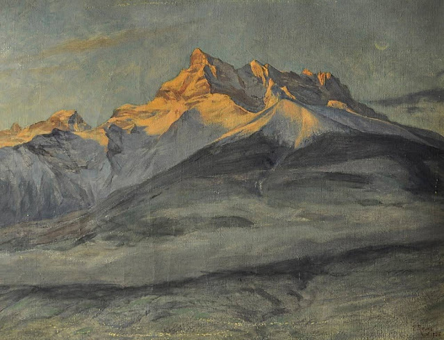
DENTS DU MIDI PAINTED BY FREDERIC ROUGE


FREDERIC ROUGE (1867-1950) The Dents du Midi  (3,114 m to 3,257 m -10,216 ft to10,685 ft)  Switzerland   In Les Les-Dents du Midi en hiver, 1906, Huile sur toile, Fondation Frédéric Rouge

FREDERIC ROUGE (1867-1950)
The Dents du Midi  (3,114 m to 3,257 m -10,216 ft to10,685 ft) 
Switzerland

 In Les Les-Dents du Midi en hiver, 1906, Huile sur toile, Fondation Frédéric Rouge


The painter
Frederic Rouge was born in Aigle (Switzerland), on 27 April 1867. His parents owned a small shoe factory. After school, he attended the Fine Arts College in Basel for a year, coming first of his class at the end of the course. Then, after a while studying with the history painter Vigier, he came back home to live with his parents. To perfect his technique, the artist spent three consecutive winters at the Julian Academy in Paris "where Professor Boulanger, exacting and irascible, was hard to please". In 1903, Frederic Rouge settled in Ollon, not far from Aigle, in a pleasant house called "The Cedars". Today Ollon is still a large village surrounded by orchards and vineyards bathed in sunshine, its dense forests teeming with wildlife, and where the Alpine scenery reigns supreme.
He wholeheartedly loved this region which provided him with so many subjects of inspiration, and whose every season, scene and mood he rendered so faithfully.
Frederic Rouge was suffering from paralysis when he died on 13 February 1950. All his life he had remained unassuming, an honest man and a great artist, true to his ideals, a citizen devoted to the cause of liberty - perhaps not the best way to make one's fortune, even for a painter of talent !

The mountains
The Dents du Midi (Teeth of the south) (3,114 m to 3,257 m -10,216 ft to10,685 ft) are mountain range, 3 kilometers long, located in the Chablais Alps in the canton of Valais in Switzerland. Overlooking the valley of Illiez and Rhône Valley on south, they face the lake Salanfe, an artificial reservoir, and are part of the geological whole massif Giffre.
The name "Dents du Midi" is recent. The people formerly called them "Dents Tsallen". It was only towards the end of the19e century that the name "Dents du Midi" came officially.
Each « tooth » had several names over the centuries and according to its geological evolution.
- The "Cime de l'Est" (3,178 meters) called "Mont Novierre" before the mid-17th century, and "Mont Saint-Michel "after landslides in 1635 and 1636 and finally "Dent Noire" (until the 19th century).
- The "Dent Jaune" (3,186 m) was called the "Dent Rouge" until 1879.
- The "Doigt de Champéry" (in 1882) and then the Doigt Salanfe (in 1886) turned just into "Les Doigts" (Fingers) (3,205 m and 3210 m).
- The "Haute Cime" (3,257 m) also had many names : "Dent de L’ouest" (until 1784)an then "Dent du Midi", "Dent de Tsallen" and "Dent de Challent."
- As for l’Eperon (3,114 m) (The Spur), it is assumed that there were two peaks but a landslide in the Middle Ages significantly changed its crest.
- The Forteresse (3,164 m) and the Cathedral (3,160 m) have not changed names.
The evolution of this massif continues nowadays. So on the morning of 30 October 2006, a volume of 1 million m3 of rock broke away from the edge of the Haute Cime and slid down the slope to an altitude of about 3000 m. The event did not present danger to the nearby village of Val-d'Illiez but roads and trails were closed for security reasons. According to the cantonal geologist, the landslide was caused by the thawing of rocks, helped by warm summers of recent years. 

____________________________________
2022 - Wandering Vertexes...
by Francis Rousseau


Wednesday, April 6, 2022

THE DOM AND THE TÄSCHORN PAINTED BY W. F. BURGER

WILHELM FRIEDRICH BURGER (1882 -1964 ) The Dom (4,545 m (14,911 ft) The Täschhorn (4,491 m -14,734 ft) Switzerland  In The Dom and Täschhorn above Zermatt, watercolour, 30.5 x 37.5 cm. Courtesy John Mitchell Fine Arts London

WILHELM FRIEDRICH BURGER (1882 -1964)
The Dom (4,545 m (14,911 ft)
The Täschhorn (4,491 m -14,734 ft)
Switzerland

In The Dom and Täschhorn above Zermatt, watercolour, 30.5 x 37.5 cm.
Courtesy John Mitchell Fine Arts London

 
The mountains
The Dom (4 ,545 m  -14,911 ft)  is a mountain of the Pennine Alps, located between Randa and Saas-Fee in the canton of Valais in Switzerland. It is the seventh highest summit in the Alps, overall.  Based on prominence, it can be regarded as the third highest mountain in the Alps, and the second highest in Switzerland, after Monte Rosa. The Dom is the main summit of the Mischabel group (German: Mischabelhörner), which is the highest massif lying entirely in Switzerland. The Dom is noteworthy for its 'normal route' of ascent having the greatest vertical height gain of all the alpine 4000 metre peaks, and none of that route's 3,100 metres of height can be achieved using mechanical means. Although Dom is a German cognate for 'dome', it can also mean 'cathedral' and the mountain is named after Canon Berchtold of Sitten cathedral, the first person to survey the vicinity. The former name Mischabel comes from an ancient German dialect term for pitchfork, as the highest peaks of the massif stand close to each other.
The Täschhorn (4,491 m - 14,734 ft) is  lying south of the Dom within the Mischabel range.  Täschorn is a little lower than Dom but more difficult to access because there is mandatory rock climbing. Täschorn is a 3 sides pyramid.  East face is above Saas Fee, W face is above Täsch (last village before Zermatt), and huge South face is above Täschalp (Ottavan).  Each side belongs a glacier: on Täsch side is Kingletscher, on Ottavan side is Weingartengletscher, on Saas side is Feegletscher. The first ascent of the mountain was by John Llewelyn Davies and J. W. Hayward with guides Stefan and Johann Zumtaugwald and Peter-Josef Summermatter on 30 July 1862. The normal route is on the SE ridge starting from Mischabeljoch. To join the Mischabel pass, it's possible to come from either Saas Fee side or Täsch side.

 
The painter
Wilhelm, or Willy, Burger is nowadays widely recognized as one of the leading graphic artists of his time. His lithograph posters such as, Jungfraubahn. Station Jungfrau: Joch 3457m. Aletschgletscher, 1914 and St. Moritz, 1912are far better known – and more costly – than his oil paintings. However, he was first and foremost a painter by training who apprenticed in Zurich before leaving for Philadelphia and New York in 1908. He returned to Switzerland in 1913 where he set up a studio in Rüschlikon on the west shore of Lake Zürich from where he would travel throughout the Alps, the Mediterranean and as far afield as Egypt for his commissions. Although Burger cannot be categorized as a Symbolist in the strictest sense, his palette, his penchant for jagged outlines and his ethereal skies owe much to Ferdinand Hodler, the leading Swiss painter of the late nineteenth century. Hovering between Realism and Symbolism in style, this late afternoon view over the Zürichsee from the edge of the lake at Rüschlikon is an overt homage to Hodler who painted nearly 150 pictures of the Swiss lakes, many of them in a similar, panoramic format. Burger went so far as to sign his picture with a more spidery signature than usual – a pastiche of Hodler’s.
From 1901 onwards, Hodler began to concentrate on a series of acclaimed visions of Lac Léman (Geneva) in which he delineated horizontal bands of differing colours and tone. As he developed the theme of receding lines across the lake, or ‘parallelism’, as he called it, Mont Blanc and its surrounding peaks were introduced into the background. Hodler died in 1918 but in these late paintings he sought to express his concept of unité – the idea that there was a fundamental order to the universe and the artist’s role was to reveal it.

____________________________________
2022 - Wandering Vertexes...
by Francis Rousseau

Sunday, April 3, 2022

THE CAP D'ANTIBES PAINTED BY NICOLAS DE STAËL


NICOLAS DE STAËL (1914-1955) Cap d'Antibes (19 m - 62,3 ft) France (Var)  In  Marine au cap d'Antibes, 1954 oil on canvas, 88.3 x 129.5 cm, Private collection.

NICOLAS DE STAËL (1914-1955)
Cap d'Antibes (19 m - 62,3 ft)
France (Alpes Maritimes)

In  Marine au cap d'Antibes, 1954 oil on canvas, 88.3 x 129.5 cm, Private collection.


The Cap
Cap d'Antibes commonly refers to a peninsula located south of Antibes and east of Juan-les-Pins, on the Côte d'Azur in France. Geographical Cap d'Antibes is located to the south of this peninsula, near Argent Faux Cove and Villa Eilenroc, on the coastal path at the start of Golfe Juan. The history of Cap d'Antibes is linked to that of Antibes, whose exceptional site has been known since ancient times.
The coastal path known as “Tire-Poil” allows walkers to explore the cape in good weather, from the Garoupe beach car park to Villa Eilenroc. Walking as close as possible to the waves, this 2.7 km route makes its way through the steep rocks and along the imposing walls of the Garoupe and Croë castles. It offers an exceptional panorama, to the west on the Lérins islands, and to the east on the first summits of Mercantour. Built at the highest point of the cape and next to the ancient chapel of Notre Dame de Bon Port, the Garoupe lighthouse dominates the Gulf of Juan and the Bay of Angels. L'Abri de l'Olivette, a port-shelter where typical boats of the region anchor, is located on its west coast.The site benefits from the visit of personalities from the world of cinema, mainly during the Cannes Film Festival, which increases the notoriety of the place.  It was around the middle of the 19th century that the Cap d'Antibes really began to develop.  At that time, wealthy tourists from all over Europe, especially England and Russia, discovered the place and built luxurious homes there.  It was the Comte de Fersen, colonel and aide-de-camp to the Tsar, who opened up Cap d'Antibes in 1863 by tracing a road around the peninsula. Thus, the knight James Close, former banker of François II (king of the Two Sicilies), settled in 1864 in Antibes and bought 17,000 m2 of land there in Cap before dying in 1865. In 1880, the current location of Juan-les-Pins was discovered by the Duke of Albany, son of Queen Victoria. At that time, Juan-les-Pins was just a pine forest, bordered by idyllic sandy beaches. Juan-les-Pins was also called Albany-les-Bains until 1884. In 1893, Georges Gallice acquired land located at the start of the Cap road and a small port attached to his property would later become Port Gallice.

The painter
Nicolas de Staël was a French painter of Russian origin known for his use of a thick impasto and his highly abstract landscape painting. Nicolas de Staël was born Nikolai Vladimirovich Stael von Holstein (Николай Владимирович Шталь фон Гольштейн) in Saint Petersbourg (Russia), into the family of a Baron Vladimir Stael von Holstein, the last Commandant of the Peter and Paul Fortress. De Staël's family was forced to emigrate to Poland in 1919 because of the Russian Revolution ; both his father and stepmother died in Poland and the orphaned Nicolas de Staël was sent with his older sister Marina to Brussels to live with a Russian family (1922)...
- More about Nicolas de Stael biography
___________________________________________

2022 - Wandering Vertexes...
by Francis Rousseau