google.com, pub-0288379932320714, DIRECT, f08c47fec0942fa0 GRAVIR LES MONTAGNES... EN PEINTURE: Search results for Vittorio Sella
Showing posts sorted by date for query Vittorio Sella. Sort by relevance Show all posts

Sunday, April 14, 2024

LE PIC ALEXANDRA PHOTOGRAPHIÉ PAR VITTORIO SELLA EN 1906

VITTORIO SELLA (1859-1943) Alexandra Peak / Mount Stanley (5, 091m) Congo - Uganda border  In Alexandra peak , western glacier, photographie à la chambre, 1906

VITTORIO SELLA (1859-1943)
Alexandra Peak / Mount Stanley (5, 091m)
Congo - Uganda border

In Alexandra peak , western glacier, photographie à la chambre, 1906


Le photographe
Vittorio Sella est un alpiniste et photographe italien qui a hérité sa passion pour la montagne de son oncle, Quintino Sella, fondateur du Club Alpin Italien. Il accomplit de nombreuses ascensions remarquables dans les Alpes, le premier hivernage au Cervin et au Mont Rose (1882) et la première traversée hivernale du
Mont Blanc (1888) et des Rouies (1900).
Il participe à diverses expéditions hors d'Italie :
- Trois dans le Caucase en 1889, 1890 et 1896 où un sommet porte encore son nom ;
- L'ascension du Mont Saint Elias en Alaska en 1897 ;
- Sikkim et Népal en 1899 ;
- Gravit le mont Stanley en Ouganda en 1906 lors d'une expédition dans le Rwenzori ;
- Reconnaissance au K2 en 1909 ;
- Au Maroc en 1925.
Lors d'expéditions en Alaska, en Ouganda et au Karakoram, il accompagne le duc des Abruzzes, le prince Luigi Amedeo di Savoia.
Sella continue la pratique de l'escalade jusqu'à ses vieux jours, complétant sa dernière tentative sur le Cervin à l'âge de 76 ans ; une ascension dont il a dû interrompre la montée suite à un accident dans lequel l'un de ses guides s'est blessé. Il mourut dans sa ville natale pendant la Seconde Guerre mondiale. Sa collection photographique est désormais gérée par la Fondation Sella.
Ses photos de montagne sont encore aujourd'hui considérées comme parmi les plus belles jamais réalisées.
Jim Curran estime que « Sella reste probablement le plus grand photographe de montagne. Son nom est synonyme de perfection technique et de raffinement esthétique. »
La qualité des images de Vittorio Sella s'explique en partie par l'utilisation d'une caméra de visualisation 30 × 40 cm, malgré la difficulté de transport d'un tel appareil, à la fois lourd et fragile dans des endroits inaccessibles ; pour pouvoir le transporter en toute sécurité, il a dû fabriquer des pièces spéciales pouvant être rangées dans des sacoches. Ses photographies ont été largement diffusées, soit dans la presse, soit dans les galeries, et ont été unanimement saluées ; Ansel Adams, qui a pu en admirer trente et un lors d'une exposition organisée au Sella American Sierra Club, a déclaré qu'ils lui avaient inspiré « un sentiment d'émerveillement religieux ». Beaucoup de ses clichés ont été pris en montagne pour la toute première fois dans l'Histoire, ce qui leur confère une grande valeur artistique, historique mais aussi scientifique ; par exemple, on pourrait mesurer le déclin des glaciers du Rwenzori en Afrique centrale.

La montagne
Le pic Alexandra (5 091 m) fait partie du mont Stanley situé dans la chaîne du Rwenzori, la plus haute montagne de la République démocratique du Congo et de l'Ouganda, et la troisième plus haute d'Afrique, après le mont Kilimandjaro (5 895 m). et le mont Kenya (5 199 m).
Le mont Stanley se compose de deux sommets jumeaux et de plusieurs sommets inférieurs qui sont :
Pic Margherita (5 109 m), Pic Alexandra (5 091 m), Pic Albert (5 087 m), Pic Savoia (4 977 m - 16 330 pieds), Pic Ellena (4 968 m - 16 300 pieds), Elizabeth Peak (4 929 m), Phillip Peak (4 920 m), Moebius Peak (4 916 m) et Great Tooth (4 603 m).
Le pic et plusieurs autres sommets environnants sont suffisamment hauts pour supporter des glaciers. Le mont Stanley doit son nom au journaliste et explorateur Sir Henry Morton Stanley. Il fait partie du parc national des Monts Rwenzori, un site classé au patrimoine mondial de l'UNESCO.
Le mont Stanley a été escaladé pour la première fois en 1906 par le prince Luigi Amedeo di Savoia, duc des Abruzzes (1873-1933), J. Petigax, C. Ollier et J. Brocherel. Il est également connu pour ses explorations de l'Arctique et pour ses expéditions d'alpinisme, notamment au Mont Saint Elias (Alaska-Yukon) et au K2 (Pakistan-Chine). Margherita Peak doit son nom à la reine Margherita d'Italie, cousine du prince.

 ______________________________________

2024 - Gravir les montagnes en peinture
Un blog de Francis Rousseau


Tuesday, September 12, 2023

UN DES 25 VOLCANS DE L'ILE D'URUP EN CARTE POSTALE (1925)


CARTES POSTALES ANCIENNES (1925) ,Volcan d'Urup (1426m) Russie (Iles Kouriles)

CARTES POSTALES ANCIENNES (1925)
Volcan d'Urup (1,426m)
Russie (Iles Kouriles)


Le volcan


Urup du japonais :得撫島 (1,426m) est une île volcanique inhabitée de la chaîne des Iles Kouriles au sud de la mer d'Okhotsk, nord-ouest de l'Océan Pacifique.
 Urup est essentiellement de forme rectangulaire, avec un axe long de 120 kilomètres  et un axe étroit d'environ 20 kilomètres  C'est la quatrième plus grande des îles Kouriles, avec une superficie de 1 430 kilomètres carrés  Le point culminant est Gora Ivao à 1 426 mètres.  Un certain nombre de minuscules îlots et rochers dont celui qui a été photographié ci-dessus, sont dispersés autour de la côte d'Urup.
 Le détroit entre Urup et Iturup est connu sous le nom de Détroit de Vries d'après l'explorateur néerlandais Maarten Gerritsz Vries, le premier européen enregistré à explorer la région. Le détroit entre Urup et Simushir est connu sous le nom de Détroit de Bussol, d'après le mot français " boussole ", qui était le nom d'un des navires de La Pérouse, marin français qui explora la région des îles Kouriles en 1780. 
Urup se compose de quatre grands groupes de stratovolcans actifs ou dormants de l'île. Le cône le plus au sud-est coupe en deux une vallée glaciaire, formant un lac. Pendant la seconde guerre mondiale, tous les habitants civils de l'île ont été déplacés vers les îles d'origine japonaises, et à la fin de la guerre, l'armée impériale japonaise avati stationné environ 6000 soldats sur Urup. Lors de l' invasion des îles Kouriles par l' Union Soviétique après la fin de la seconde guerre mondiale, les forces japonaises d'Urup se sont rendues sans résistance. En 1952, lors de la signature du traité de San Francisco, le Japon a renoncé à sa revendication sur l'île. Les troupes frontalières soviétiques ont occupé les anciennes installations militaires japonaises. Les troupes ont été retirées lors de la dissolution de l'URSS en 1991.

Cartes postales anciennes
Les cartes postales ont été colorisées dès leur apparition sur le marché à la fin du 19e siècle ; les photos en noir et blanc étaient repeintes à la main par des femmes avec des pinceaux très fins, puis un vernis était appliqué pour fixer ces couleurs toujours très contrastées... et parfois très éloignées de la réalité !
Les cartes postales sont devenues populaires au tournant du 20e siècle, notamment pour envoyer de courts messages à des amis et à des proches. Elles ont été collectionnées dès le début et sont toujours recherchées aujourd'hui par les collectionneurs  de photographie de publicité, de souvenirs de guerre, d'histoire locale et de bien d'autres catégories. Les cartes postales étaient un engouement international, publiées dans le monde entier. La Detroit Publishing Co. et Teich & Co. étaient deux des principaux éditeurs aux États-Unis, et parfois des particuliers imprimaient également leurs propres cartes postales. Yvon était le plus célèbre de France. De nombreux éditeurs individuels ou anonymes ont existé dans le monde et notamment en Afrique et en Asie (Japon, Thaïlande, Népal, Chine, Java) entre 1920 et 1955. Ces photographes étaient pour la plupart des notables locaux, des militaires, des guides officiels appartenant aux armées coloniales (britanniques français, belge...) qui disposaient parfois d'un matériel assez sophistiqué et produisaient volontiers des photogrammes en couleur ou des explorateurs, navigateurs, alpinistes (Vittorio Sella et l'Archiduc des Abruzzes futur roi d'Italie reste le plus célèbre d'entre eux).
Il existe de nombreux types de cartes postales anciennes à collectionner.
Les cartes postales résistantes à la lumière étaient fabriquées avec du papier de soie entouré de deux morceaux de papier ordinaire, de sorte que la lumière passait à travers. Les cartes postales dépliantes, populaires dans les années 1950, avaient plusieurs cartes postales attachées dans une longue bande. Les cartes postales photographiques réelles (RPPC) sont des photographies avec un support de carte postale.
Des cartes postales originales ont été fabriquées à partir de bois, d'aluminium, de cuivre et de liège. Les cartes postales en soie - souvent brodées sur une image imprimée - étaient enroulées autour de carton et envoyées dans des enveloppes transparentes en papier cristal; ils étaient particulièrement populaires pendant la Première Guerre mondiale.
Dans les années 1930 et 1940, les cartes postales étaient imprimées sur du papier aux couleurs vives conçu pour ressembler à du lin.

 ________________________________________

2023 - Gravir les montagnes en peinture
Un blog de Francis Rousseau


Monday, August 7, 2023

LE GLACIER DU MONT PERS EN CARTE POSTALE DE 1890


CARTES POSTALES ANCIENNES Mont Pers (3,207m) Suisse   In  Glacier du Mont Pers, Grisons, Haute Engadine, La Suisse en Couleur, Carte postale, 1890,


CARTES POSTALES ANCIENNES
Mont Pers (3,207m)
Suisse

 In  Glacier du Mont Pers, Grisons, Haute Engadine, La Suisse en Couleur, Carte postale, 1890, 

La montagne
Mont Pers (3,207 m) est une montagne dechaîne des Alpes Berninoises, surplombant le glacier de Morteratsch dans le canton suisse des Grisons. Il se trouve au nord de Diavolezza, d'où un sentier mène à son sommet. Son nom provient du romanche et signifie "montagne perdue". Cela reste néanmoins  aujourd'hui une montagne facile à gravir grâce au téléphérique de Diavolezza qui offre avec une vue exceptionnelle sur  Piz Palü, lePiz Bernina et lz  Piz Morteratsch.

Cartes postales anciennes
Les cartes postales ont été colorisées dès leur apparition sur le marché à la fin du 19e siècle ; les photos en noir et blanc étaient repeintes à la main par des femmes avec des pinceaux très fins, puis un vernis était appliqué pour fixer ces couleurs toujours très contrastées... et parfois très éloignées de la réalité !
Les cartes postales sont devenues populaires au tournant du 20e siècle, notamment pour envoyer de courts messages à des amis et à des proches. Elles ont été collectionnées dès le début et sont toujours recherchées aujourd'hui par les collectionneurs  de photographie de publicité, de souvenirs de guerre, d'histoire locale et de bien d'autres catégories. Les cartes postales étaient un engouement international, publiées dans le monde entier. La Detroit Publishing Co. et Teich & Co. étaient deux des principaux éditeurs aux États-Unis, et parfois des particuliers imprimaient également leurs propres cartes postales. Yvon était le plus célèbre de France. De nombreux éditeurs individuels ou anonymes ont existé dans le monde et notamment en Afrique et en Asie (Japon, Thaïlande, Népal, Chine, Java) entre 1920 et 1955. Ces photographes étaient pour la plupart des notables locaux, des militaires, des guides officiels appartenant aux armées coloniales (britanniques français, belge...) qui disposaient parfois d'un matériel assez sophistiqué et produisaient volontiers des photogrammes en couleur ou des explorateurs, navigateurs, alpinistes (Vittorio Sella et l'Archiduc des Abruzzes futur roi d'Italie reste le plus célèbre d'entre eux).
Il existe de nombreux types de cartes postales anciennes à collectionner.
Les cartes postales résistantes à la lumière étaient fabriquées avec du papier de soie entouré de deux morceaux de papier ordinaire, de sorte que la lumière passait à travers. Les cartes postales dépliantes, populaires dans les années 1950, avaient plusieurs cartes postales attachées dans une longue bande. Les cartes postales photographiques réelles (RPPC) sont des photographies avec un support de carte postale.
Des cartes postales originales ont été fabriquées à partir de bois, d'aluminium, de cuivre et de liège. Les cartes postales en soie - souvent brodées sur une image imprimée - étaient enroulées autour de carton et envoyées dans des enveloppes transparentes en papier cristal; ils étaient particulièrement populaires pendant la Première Guerre mondiale.
Dans les années 1930 et 1940, les cartes postales étaient imprimées sur du papier aux couleurs vives conçu pour ressembler à du lin.

 ________________________________________

2023 - Gravir les montagnes en peinture
Un blog de Francis Rousseau

Thursday, August 25, 2022

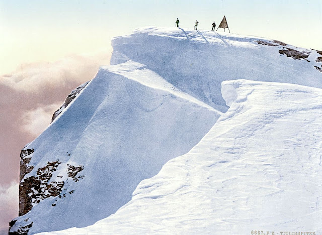
THE TITLIS IN VINTAGE POSTCARDS 1890

VINTAGE POSCARDS Titlis (3,238 m -10,623ft) Switzerland  In " Titlis Spitze, Unterwald - La Suisse en Couleur " postcard, 1890, The Library of Congress Photographs Division, Washington DC

VINTAGE POSCARDS
Titlis (3,238 m -10,623ft)
Switzerland

In " Titlis Spitze, Unterwald - La Suisse en Couleur " postcard, 1890,
The Library of Congress Photographs Division, Washington DC


The mountain
Titlis  (3,238 m - 10,623 ft) is a mountain of the Uri Alps, located on the border between the cantons of Obwalden and Bern. It is the highest summit of the range north of the Susten Pass, between the Bernese Oberland and Central Switzerland. It is mainly accessed from Engelberg (OW) on the north side and is famous as the site of the world's first rotating cable car.  The cable car system connects Engelberg (996 m (3,268 ft)) to the summit of Klein Titlis (3,028 m (9,934 ft)) through the three stages of Gerschnialp (1,262 m (4,140 ft)), Trübsee (1,796 m (5,892 ft)) and Stand (2,428 m (7,966 ft)), although somewhat recently, a newer, direct route was created that bypassed Gerachnialp, going directly to Trübsee.
The last part of cable car leads above the glacier. At Klein Titlis, it is possible to visit an illuminated glacier cave from an entrance within the cable-car station, which also includes shops and restaurants. The Titlis Cliff Walk, the highest elevation suspension bridge in Europe, opened in December 2012, giving views across the Alps. Many people use Titlis as a cheaper and easier option than Jungfraujoch.
In earlier times, Titlis was known under the names Wendenstock or Nollen. The Reissend Nollen and the Wendenstöcke are the nearest western neighbours to the mountain, slightly lower than Titlis, but with sharp rugged peaks. In a document of 1435 the mountain is called Tuttelsberg(Tutilos mountain), referencing to a man named Tutilos, who was probably a local farmer. The name, from Tutilos Berg, became Titlisberg and later Titlis.
The first ascent of Titlis was probably made in the year 1739. It was done by Ignaz Hess, J. E. Waser and two other men from Engelberg.  The first written evidence of an ascent is found in the Engelberger Dokumente. They mention a party of four men that reached the summit in 1744.
 On 21 January 1904 the first ski ascent of Titlis was made by Joseph Kuster and Willi Amrhein. In March 1967 the cable car to Klein Titlis (3,032 m) was inaugurated. In December 2012, the Titlis Cliff Walk opened to commemorate the 110th anniversary of the Engelberg-Gerschnialp cableway.


Vintage postcards
Postcards were colorized as soon as they appeared on the market at the end of 19th century ; the photos were then repainted by hand by women with very fine brushes, then a varnish was applied to fix these colors which were always very contrasting... and sometimes very far from reality!
Postcards became popular at the turn of the 20th century, especially for sending short messages to friends and relatives. They were collected right from the start, and are still sought after today by collectors of pop culture, photography, advertising, wartime memorabilia, local history, and many other categories. Postcards were an international craze, published all over the world. The Detroit Publishing Co. and Teich & Co. were two of the major publishers in the U.S, and sometimes individuals printed their own postcards as well. Yvon were the most famous in France. Many individual or anonymous publishers did exist around the world and especially in Africa and Asia (Japan, Thailand, Nepal, China, Java) between 1920 and 1955. These photographer were mostly local notables, soldiers, official guides belonging to the colonial armies (british french, belgium...) who sometimes had rather sophisticated equipment and readily produced colored photograms or explorers, navigators, climbers (Vittorio Sella and the Archiduke of Abruzzi future king of Italy remains the most famous of them).
There are many types of collectible vintage postcards.
Hold-to-light postcards were made with tissue paper surrounded by two pieces of regular paper, so light would shine through. Fold-out postcards, popular in the 1950s, had multiple postcards attached in a long strip. Real photograph postcards (RPPCs) are photographs with a postcard backing.
Novelty postcards were made using wood, aluminum, copper, and cork. Silk postcards–often embroidered over a printed image–were wrapped around cardboard and sent in see-through glassine paper envelopes; they were especially popular during World War I.
In the 1930s and 1940s, postcards were printed on brightly colored paper designed to look like linen.
Most vintage postcard collectors focus on themes, like Christmas, Halloween, portraits of movie stars, European royalty and U.S. presidents, wartime imagery, and photos of natural disasters or natural wonders. Not to mention cards featuring colorful pictures by famous artists like Alphonse Mucha, Harrison Fisher, Ellen Clapsaddle, and Frances Brundage.

__________________________________________
2022 - Wandering Vertexes...
by Francis Rousseau


Friday, August 19, 2022

THE K2 PEAK PHOTOGRAPHED BY VITTORIO SELLA IN 1909


VITTORIO SELLA (1859-1843)    The K2  peak (8,611m - 28,251 ft)  China - Pakistan border  Photographed during the 1909 expedition  led by Prince Luigi Amedeo, Duke of the Abruzzi

VITTORIO SELLA (1859-1843)  
 The K2  peak (8,611m - 28,251 ft) 
China - Pakistan border

Photographed during the 1909 expedition 
led by Prince Luigi Amedeo, Duke of the Abruzzi 

The artist
Vittorio Sella is a mountain italian climber and photographer who took his passion for mountains from his uncle, Quintino Sella, founder of the Italian Alpine Club.  He accomplished many remarkable climbs in the Alps, the first wintering in the Matterhorn and Mount Rose (1882) and the first winter crossing of Mont Blanc (1888).
He took part in various expeditions outside Italy:
- Three in the Caucasus in 1889, 1890 and 1896 where a summit still bears his name;
- The ascent of Mount Saint Elias in Alaska in 1897;
- Sikkim and Nepal in 1899;
- Possibly climb Mount Stanley in Uganda in 1906 during an expedition to the Rwenzori;
- Recognition at K2  in 1909 (aAbove)
- In Morocco in 1925.
During expeditions in Alaska, Uganda and Karakoram (K2), he accompanied the Duke of Abruzzi, Prince Luigi Amedeo di Savoia.
Sella continues the practice of climbing into his old age, completing his final attempt in the Matterhorn at the age of 76; a climb he had to interrupt the rise following an accident in which one of his guides injured. He died in his hometown during World War II.  His photographic collection is now managed by the Sella Foundation.
His photos mountain are still  considered today to be among the finest ever made.
Jim Curran believes that "Sella remains probably the greatest photographer of the mountain.  His name is synonymous with technical perfection and aesthetic refinement. "
The quality of the pictures of Vittorio Sella is partly explained by the use of a view camera 30 × 40 cm, despite the difficulty of the transportation of such a device, both heavy and fragile in places inaccessible; to be able to transport it safely, he had to make special pieces that can be stored in saddle bags.  His photographs have been widely distributed, either through the press or in the galleries, and were unanimously celebrated; Ansel Adams, who was able to admire thirty-one in an exhibition that was organized at Sella American Sierra Club, said they inspired him "a religious kind of sense of wonder."  Many of his pictures were taken in the mountains for the very first time in the History, which give them a much artistic, historical  but also scientific value ; for example, one could measure the decline in the Rwenzori glaciers in Central Africa.

The mountain 
K2 peak (8,611m - 28,251 ft)  also known as Mount Godwin-Austen or Chhogori is the second highest mountain in the world, after Mount Everest. It is located on the China-Pakistan border between Baltistan, in the Gilgit–Baltistan region of northern Pakistan, and the Taxkorgan Tajik Autonomous County of Xinjiang, China.
The name K2 is derived from the notation used by the Great Trigonometric Survey of British India. Thomas Montgomerie made the first survey of the Karakoram from Mount Haramukh, some 210 km (130 miles) to the south, and sketched the two most prominent peaks, labeling them K1 and K2.
The policy of the Great Trigonometric Survey was to use local names for mountains wherever possible and K1 was found to be known locally as Masherbrum. K2, however, appeared not to have acquired a local name, possibly due to its remoteness. The mountain is not visible from Askole, the last village to the south, or from the nearest habitation to the north, and is only fleetingly glimpsed from the end of the Baltoro Glacier, beyond which few local people would have ventured. The name Chogori, derived from two Balti words, chhogo ("big") and ri ("mountain")  has been suggested as a local name, but evidence for its widespread use is scant. It may have been a compound name invented by Western explorers or simply a bemused reply to the question "What's that called?" It does, however, form the basis for the name Qogir (simplified Chinese: 乔戈里峰; traditional Chinese: 喬戈里峰; pinyin: Qiбogēlǐ Fēng) by which Chinese authorities officially refer to the peak. Other local names have been suggested including Lamba Pahar ("Tall Mountain" in Urdu) and Dapsang, but are not widely used.
Lacking a local name, the name Mount Godwin-Austen was suggested, in honor of Henry Godwin-Austen, an early explorer of the area, and while the name was rejected by the Royal Geographical Society, it was used on several maps, and continues to be used occasionally.
The surveyor's mark, K2, therefore continues to be the name by which the mountain is commonly known. It is now also used in the Balti language, rendered as Kechu or Ketu (Urdu: کے ٹو‎). The Italian climber Fosco Maraini argued in his account of the ascent of Gasherbrum IV that while the name of K2 owes its origin to chance, its clipped, impersonal nature is highly appropriate for so remote and challenging a mountain. He concluded that it was ...
K2 is the highest point of the Karakoram range and the highest point in both Pakistan and Xinjiang.

Friday, May 13, 2022

ALEXANDRA PEAK AND MARGHERITA PEAK BY VITTORIO SELLA


VITTORIO SELLA (1859-1943) Alexandra Peak / Mount Stanley (5,091m - 16,703 ft) Congo - Uganda border    In Alexandra peak and Margherita peak from the Stanley Plateau, photo, 1906


VITTORIO SELLA (1859-1943)
Alexandra Peak / Mount Stanley (5, 091m - 16,703 ft)
Margherita Peak / mount stanley (5,109 m-16,763 ft)
Congo - Uganda border

  In Alexandra peak  and Margherita peak from the Stanley Plateau, photo, 1906


The mountain
Alexandra Peak (5,091m - 16,703ft) is part of Mount Stanley located in the Rwenzori range, the highest mountain of both Democratic Republic of the Congo and Uganda, and the third highest in Africa, after Mount Kilimanjaro (5,895 m -19,340ft) and Mount Kenya (5,199 m - 17,057ft).
Mount Stanley consists of two twin summits and several lower peaks which are :
Margherita Peak (5,109m - 16,763ft), Alexandra Peak (5,091m - 16,703ft), Albert Peak (5,087m - 16,690ft), Savoia Peak (4,977m - 16,330ft), Ellena Peak (4,968m -16,300ft), Elizabeth Peak (4,929m - 16,170 ft), Phillip Peak (4,920m - 16,140ft), Moebius Peak (4,916m - 16,130 ft) and Great Tooth (4,603m - 15,100ft).
The peak and several other surrounding peaks are high enough to support glaciers. Mount Stanley is named for the journalist and explorer, Sir Henry Morton Stanley. It is part of the Rwenzori Mountains National Park, a UNESCO world Heritage Site.
Mt. Stanley was first climbed in 1906 by the Prince Luigi Amedeo di Savoia , Duke of the Abruzzi, (1873-1933), J. Petigax, C. Ollier, and J. Brocherel. He is known as well for his Arctic explorations and for his mountaineering expeditions, particularly to Mount Saint Elias (Alaska–Yukon) and K2 (Pakistan–China). Margherita Peak is named after Queen Margherita of Italy the prince's cousin.
The Rwenzori Mountains National Park is considered a model for integration of cultural values into the Protected Area Management framework as an innovative approach to resource management, the first of its kind in Africa. As a result the local communities have embraced collaborative resource management initiatives. Given its significance as one of the biodiversity hotspots in the Albertine Rift, various local and international NGOs have supported the management and conservation of the property. A General Management Plan guides management operations on-site. Key challenges to address include illegal felling of trees, snow recession due to global warming, human population pressure adjacent to the property and management of waste generated through tourism operations. UWA is addressing the above threats through resource protection, community conservation education, research and ranger-based monitoring, ecotourism and transboundary initiatives with the DRC. The long-term maintenance of the integrity of the property will be achieved through sustainable financing, ecological monitoring, continued collaboration with key stakeholders and regional cooperation.

The artist
Vittorio Sella is a mountain italian climber and photographer who took his passion for mountains from his uncle, Quintino Sella, founder of the Italian Alpine Club. He accomplished many remarkable climbs in the Alps, the first wintering in the Matterhorn and Mount Rose (1882) and the first winter crossing of Mont Blanc (1888) and Les Rouies (1900).
He took part in various expeditions outside Italy:
- Three in the Caucasus in 1889, 1890 and 1896 where a summit still bears his name;
- The ascent of Mount Saint Elias in Alaska in 1897;
- Sikkim and Nepal in 1899;
- Possibly climb Mount Stanley in Uganda in 1906 during an expedition to the Rwenzori;
- Recognition at K2 in 1909;
- In Morocco in 1925.
During expeditions in Alaska, Uganda and Karakoram, he accompanied the Duke of Abruzzi, Prince Luigi Amedeo di Savoia.
Sella continues the practice of climbing into his old age, completing his final attempt in the Matterhorn at the age of 76; a climb he had to interrupt the rise following an accident in which one of his guides injured. He died in his hometown during World War II. His photographic collection is now managed by the Sella Foundation.
His photos mountain are still considered today to be among the finest ever made.
Jim Curran believes that "Sella remains probably the greatest photographer of the mountain. His name is synonymous with technical perfection and aesthetic refinement. "
The quality of the pictures of Vittorio Sella is partly explained by the use of a view camera 30 × 40 cm, despite the difficulty of the transportation of such a device, both heavy and fragile in places inaccessible; to be able to transport it safely, he had to make special pieces that can be stored in saddle bags. His photographs have been widely distributed, either through the press or in the galleries, and were unanimously celebrated; Ansel Adams, who was able to admire thirty-one in an exhibition that was organized at Sella American Sierra Club, said they inspired him "a religious kind of sense of wonder." Many of his pictures were taken in the mountains for the very first time in the History, which give them a much artistic, historical but also scientific value ; for example, one could measure the decline in the Rwenzori glaciers in Central Africa.
___________________________

2022 - Wandering Vertexes...
by Francis Rousseau

Monday, February 21, 2022

THE TORRENTHORN IN VINTAGE POSTCARDS 1890


VINTAGE POSTCARDS The Torrenthorn (2,997 m - 9,832 ft) Switzerland (Valais)  In La Suisse en couleurs : Le village de Leukerbad et le Torrenthorn, Valais,  Carte postale 1890


VINTAGE POSTCARDS
The Torrenthorn (2,997 m - 9,832 ft)
Switzerland (Valais)


In  "La Suisse en couleurs : Le village de Leukerbad et le Torrenthorn, Valais", Carte postale 1890


The mountain
The Torrenthorn (2,997 m - 9,832 ft) is a summit of t he Bernese Alps, in Switzerland, located in the canton of Valais,  It is located southwest of the Majinghorn. Its western slope is part of the Loèche-les-Bains ski area, of which it overlooks the village, located to the west. The Bernese Alps are a mountain range of the Alps, located in western Switzerland.  Although the name suggests that they are located in the Berner Oberland region of the canton of Bern, portions of the Bernese Alps are in the adjacent cantons of Valais, Fribourg and Vaud, the latter being usually named Fribourg Alpsand Vaud Alps respectively. The highest mountain in the range, the Finsteraarhorn, is also the highest point in the canton of Bern. The Rhône valley separates them from the Chablais Alps in the west and from the Pennine Alps in the south; the upper Rhône valley separates them from the Lepontine Alps to the southeast; the Grimsel Pass and the Aare valley separates them from the Uri Alps in the east, and from the Emmental Alps in the north; their northwestern edge is not well defined, describing a line roughly from Lake Geneva to Lake Thun. The Bernese Alps are drained by the river Aare and its tributary the Saane in the north, the Rhône in the south, and the Reuss in the east.


Vintage postcards
Postcards were colorized as soon as they appeared on the market  at the end of 19th century ; the photos were then repainted by hand by women with very fine brushes, then a varnish was applied to fix these colors which were always very contrasting... and sometimes very far from reality!
Postcards became popular at the turn of the 20th century, especially for sending short messages to friends and relatives. They were collected right from the start, and are still sought after today by collectors of pop culture, photography, advertising, wartime memorabilia, local history, and many other categories. Postcards were an international craze, published all over the world. The Detroit Publishing Co. and Teich & Co. were two of the major publishers in the U.S, and sometimes individuals printed their own postcards as well. Yvon were the most famous in France. Many individual or anonymous publishers did exist around the world and especially in Africa and Asia (Japan, Thailand, Nepal, China, Java) between 1920 and 1955. These photographer were mostly local notables, soldiers, official guides belonging to the colonial armies (british french, belgium...) who sometimes had rather sophisticated equipment and readily produced colored photograms or explorers, navigators, climbers (Vittorio Sella and the Archiduke of Abruzzi future king of Italy remains the most famous of them).
There are many types of collectible vintage postcards.
Hold-to-light postcards were made with tissue paper surrounded by two pieces of regular paper, so light would shine through. Fold-out postcards, popular in the 1950s, had multiple postcards attached in a long strip. Real photograph postcards (RPPCs) are photographs with a postcard backing.
Novelty postcards were made using wood, aluminum, copper, and cork. Silk postcards–often embroidered over a printed image–were wrapped around cardboard and sent in see-through glassine paper envelopes; they were especially popular during World War I.
In the 1930s and 1940s, postcards were printed on brightly colored paper designed to look like linen.
Most vintage postcard collectors focus on themes, like Christmas, Halloween, portraits of movie stars, European royalty and U.S. presidents, wartime imagery, and photos of natural disasters or natural wonders. Not to mention cards featuring colorful pictures by famous artists like Alphonse Mucha, Harrison Fisher, Ellen Clapsaddle, and Frances Brundage.

__________________________________________ 


2022 - Wandering Vertexes...
by Francis Rousseau


Sunday, April 18, 2021

THE MOUNT STANLEY BY VITTORIO SELLA


VITTORIO SELLA (1859-1943)
Margherita Peak / Mont Stanley (5,109 m-16,763 ft)
Congo - Uganda border

In Mt Stanley from the Esward Peak of Mt Baker - Photographed in 1906 during the Duke of Abruzzi expedition


The Mountain
Mount Stanley (5,109 m -16,762 ft) is located in the Rwenzori range and is the highest mountain of both the Democratic Republic of the Congo and Uganda, and the third highest in Africa, after Mount Kilimanjaro (5,895 m -19,340ft) and Mount Kenya (5,199 m - 17,057ft). The peak and several other surrounding peaks are high enough to support glaciers. Mount Stanley is named for the journalist and explorer, Sir Henry Morton Stanley. It is part of the Rwenzori Mountains National Park, a UNESCO world Heritage Site.
Mt. Stanley consists of two twin summits and several lower peaks which are :
Margherita Peak (5,109m - 16,763ft), Alexandra Peak (5,091m - 16,703ft), Albert Peak (5,087m - 16,690ft), Savoia Peak (4,977m - 16,330ft), Ellena Peak (4,968m -16,300ft), Elizabeth Peak (4,929m - 16,170 ft), Phillip Peak (4,920m - 16,140ft), Moebius Peak (4,916m - 16,130 ft) and Great Tooth (4,603m - 15,100ft).
Mt. Stanley was first climbed in 1906 by the Prince Luigi Amedeo di Savoia , Duke of the Abruzzi, (1873-1933), J. Petigax, C. Ollier, and J. Brocherel. He is known as well for his Arctic explorations and for his mountaineering expeditions, particularly to Mount Saint Elias (Alaska–Yukon) and K2 (Pakistan–China). Margherita Peak is named after Queen Margherita of Italy the prince's cousin.
The Rwenzori Mountains National Park is considered a model for integration of cultural values into the Protected Area Management framework as an innovative approach to resource management, the first of its kind in Africa. As a result the local communities have embraced collaborative resource management initiatives. Given its significance as one of the biodiversity hotspots in the Albertine Rift, various local and international NGOs have supported the management and conservation of the property. A General Management Plan guides management operations on-site. Key challenges to address include illegal felling of trees, snow recession due to global warming, human population pressure adjacent to the property and management of waste generated through tourism operations. UWA is addressing the above threats through resource protection, community conservation education, research and ranger-based monitoring, ecotourism and transboundary initiatives with the DRC. The long-term maintenance of the integrity of the property will be achieved through sustainable financing, ecological monitoring, continued collaboration with key stakeholders andregional cooperation.

The photographer
Vittorio Sella is a mountain italian climber and photographer who took his passion for mountains from his uncle, Quintino Sella, founder of the Italian Alpine Club. He accomplished many remarkable climbs in the Alps, the first wintering in the Matterhorn and Mount Rose (1882) and the first winter crossing of Mont Blanc (1888).
He took part in various expeditions outside Italy:
- Three in the Caucasus in 1889, 1890 and 1896 where a summit still bears his name;
- The ascent of Mount Saint Elias in Alaska in 1897
- Sikkim and Nepal in 1899
- Possibly climb Mount Stanley in Uganda in 1906 during an expedition to the Rwenzori
- Recognition at K2 and Mustagh Tower in 1909
- In Morocco in 1925.
During expeditions in Alaska, Uganda and Karakoram (K2-Chogolisa), he accompanied the Duke of Abruzzi, Prince Luigi Amedeo di Savoia.
Sella continues the practice of climbing into his old age, completing his final attempt in the Matterhorn at the age of 76; a climb he had to interrupt the rise following an accident in which one of his guides injured. He died in his hometown during World War II. His photographic collection is now managed by the Sella Foundation.
His photos mountain are still considered today to be among the finest ever made.
Jim Curran believes that "Sella remains probably the greatest photographer of the mountain. His name is synonymous with technical perfection and aesthetic refinement. "
The quality of the pictures of Vittorio Sella is partly explained by the use of a view camera 30 × 40 cm, despite the difficulty of the transportation of such a device, both heavy and fragile in places inaccessible; to be able to transport it safely, he had to make special pieces that can be stored in saddle bags. His photographs have been widely distributed, either through the press or in the galleries, and were unanimously celebrated; Ansel Adams, who was able to admire thirty-one in an exhibition that was organized at Sella American Sierra Club, said they inspired him "a religious kind of sense of wonder." Many of his pictures were taken in the mountains for the very first time in the History, which give them a much artistic, historical but also scientific value ; for example, one could measure the decline in the Rwenzori glaciers in Central Africa.

___________________________________________
2021 - Wandering Vertexes...
by Francis Rousseau

Saturday, March 21, 2020

MOUNT KAZBEK PHOTOGRAPHED IN 1889 BY VITTORIO SELLA


VITTORIO SELLA (1859-1943)
Mount Kazbek  (5,047m - 16, 558ft)
Russia - Georgia border
In Expedition in Caucasus, photo on gelatin print, 1889
The mountain
Mount Kazbek (5,047m - 16, 558ft) or Mkinvartsveri (in Georgian) or Bashlam (in Vainkah) is a dormant stratovolcano and one of the major mountains of the Caucasus located in the Kazbegi District of Georgia, just south of the border with Russia. It is the third highest peak in Georgia (after Mount Shkhara and Janga) and the seventh highest summit in the Caucasus Mountains. Kazbek is also the second highest volcanic summit in the Caucasus, after Mount Elbrus. The summit lies directly to the west of the town of Stepantsminda and is the most prominent geographic feature of the area. Mount Kazbek is the highest peak of Eastern Georgia.
The region is highly active tectonically, with numerous small earthquakes occurring at regular intervals. An active geothermal/hot spring system also surrounds the mountain.
Kazbek is a potentially active volcano, built up of trachyte and sheathed with lava, and has the shape of a double cone, whose base lies at an altitude of 1,770 m (5,800 feet). Kazbek is the highest of the volcanic cones of the Kazbegi volcanic group which also includes Mount Khabarjina (3,142 m).
Owing to the steepness of its slopes, the glaciers of Kazbek are not very large. The total combined area of all of Kazbek's glaciers is 135 km2. The best-known glacier is the Dyevdorak (Devdaraki), which creeps down the north-eastern slope into a gorge of the same name, reaching a level of 2,295 meters (7,530 feet). Kazbek's other glaciers include the Mna, Denkara, Gergeti, Abano, and Chata. The recent collapse of the Kolka Glacier, located in a valley between Mt. Jimara and Kazbek in the year 2002 was attributed to solfatara volcanic activity along the northern slope of the mountain, although there was no eruption. In addition to the 2002 event, a massive collapse of the Devdaraki Glacier on the mountain's northeastern slope which occurred on August 20, 2014, led to the death of seven people. The glacier collapse dammed the Terek River in the Daryal Gorge and flooded the Georgian Military Highway.
The photographer
Vittorio Sella is a mountain italian climber and photographer who took his passion for mountains from his uncle, Quintino Sella, founder of the Italian Alpine Club.  He accomplished many remarkable climbs in the Alps, the first wintering in the Matterhorn and Mount Rose (1882) and the first winter crossing of Mont Blanc (1888).
He took part in various expeditions outside Italy:
- Three in the Caucasus in 1889, 1890 and 1896 where a summit still bears his name;
- The ascent of Mount Saint Elias in Alaska in 1897
- Sikkim and Nepal in 1899
- Possibly climb Mount Stanley in Uganda in 1906 during an expedition to the Rwenzori
- Recognition at K2  and Mustagh Tower in 1909
- In Morocco in 1925.
More about Vittorio Sella 

_______________________________

2020 - Wandering Vertexes...
by Francis Rousseau


Monday, February 17, 2020

LUIGI DI SAVOIA PEAK / MOUNT STANLEY PHOTOGRAPHED BY VITTORIO SELLA


VITTORIO SELLA (1859-1943)
Mont Stanley / Savoia Peak (4,977 m - 16, 330 ft)
Congo - Uganda border

In Mount Luigi di Savoia panoramic taken from Mount Baker, 1906 
The Georgian Museum of Photography

The mountain
Mount Stanley (5,109 m -16,762 ft) is located in the Rwenzori range and is the highest mountain of both the Democratic Republic of the Congo and Uganda, and the third highest in Africa, after Mount Kilimanjaro (5,895 m -19,340ft) and Mount Kenya (5,199 m - 17,057ft). The peak and several other surrounding peaks are high enough to support glaciers. Mount Stanley is named for the journalist and explorer, Sir Henry Morton Stanley. It is part of the Rwenzori Mountains National Park, a UNESCO world Heritage Site.
Mt. Stanley consists of two twin summits and several lower peaks which are :
Margherita Peak (5,109m - 16,763ft), Alexandra Peak (5,091m - 16,703ft), Albert Peak (5,087m - 16,690ft), Savoia Peak (4,977m - 16,330ft), Ellena Peak (4,968m -16,300ft), Elizabeth Peak (4,929m - 16,170 ft), Phillip Peak (4,920m - 16,140ft), Moebius Peak (4,916m - 16,130 ft) and Great Tooth (4,603m - 15,100ft).
Mt. Stanley was first climbed in 1906 by the Prince Luigi Amedeo di Savoia , Duke of the Abruzzi, (1873-1933), J. Petigax, C. Ollier, and J. Brocherel. He is known as well for his Arctic explorations and for his mountaineering expeditions, particularly to Mount Saint Elias (Alaska–Yukon) and K2 (Pakistan–China). Margherita Peak is named after Queen Margherita of Italy the prince's cousin.
More about Savoia peak / Mount Stanley
The artist
Vittorio Sella is a mountain italian climber and photographer who took his passion for mountains from his uncle, Quintino Sella, founder of the Italian Alpine Club. He accomplished many remarkable climbs in the Alps, the first wintering in the Matterhorn and Mount Rose (1882) and the first winter crossing of Mont Blanc (1888).
He took part in various expeditions outside Italy:
- Three in the Caucasus in 1889, 1890 and 1896 where a summit still bears his name;
- The ascent of Mount Saint Elias in Alaska in 1897;
- Sikkim and Nepal in 1899;
- Possibly climb Mount Stanley in Uganda in 1906 during an expedition to the Rwenzori;
- Recognition at K2 in 1909;
- In Morocco in 1925.
During expeditions in Alaska, Uganda and Karakoram (K2), he accompanied the Duke of Abruzzi, Prince Luigi Amedeo di Savoia.
More about Vittorio Sella 

__________________________________________

2020 - Wandering Vertexes...
by Francis Rousseau

Sunday, October 20, 2019

KIYANJA / MOUNT BAKER BY VITTORIO SELLA

 
 https://wanderingvertexes.blogspot.com/2019/10/kiyanja-mount-baker-by-vittorio-sella.html 
VITTORIO SELLA (1859-1943) 
Kiyanja or Mount Baker (4,844m- 15,892 ft) 
Uganda
In Mount Baker,  panoramic from Grauer's Rock 1906,The Duke of the Abruzzi expedition 

The mountain
Kiyanja or Mount Baker (4,844m- 15,892 ft) is a mountain in the Rwenzori Mountains National Park in Uganda, 2.8 kilometres (1.7 mi) from the border with the Democratic Republic of the Congo. It is the sixth highest mountain in Africa. Together with Mount Stanley and Mount Speke, it forms a triangle enclosing the upper Bujuku Valley. The nearest peak is Mount Stanley, which is 2.26 kilometres (1.40 mi) to the west. The mountains lie within an area called "The Mountains of the Moon".
Like all peaks in the Ruwenzori Range, Mount Baker has multiple jagged peaks along a ridge. The highest is Edward Peak. The ridge line of Mount Baker was first reached in January 1906 by the Austrian mountaineer Rubert Grauer accompanied by two British missionaries, H. E. Maddox and H. W. Tegart. In February of that year and again in April, the same rocky point was reached by an English expedition, including Alexander F. R. Wollaston, A. B. Wosnam, and M. Carruthers. The highest point of Mount Baker was finally climbed in June by an expedition led by the Duke of the Abruzzi, with Vittorio Sella which climbed all peaks of the other five highest mountains of the Rwenzori (photo above)
The Bakonjo name for the mountain seems to have been (and currently is) "Kiyanja". On his June 1891 expedition into the Ruwenzori, Franz Stuhlmann observed the peak and named it either "Semper" or "Ngemwimbi". The Duke of the Abruzzi renamed the mountain after Samuel Baker, a 19th-century British explorer who in 1864 was the first European to sight and visit Lake Albert, just northeast of the Ruwenzori Mountains, and who had reported to glimpse "great mountainous masses away in the distance, to the south of Lake Albert."

The artist
Vittorio Sella is a mountain italian climber and photographer who took his passion for mountains from his uncle, Quintino Sella, founder of the Italian Alpine Club. He accomplished many remarkable climbs in the Alps, the first wintering in the Matterhorn and Mount Rose (1882) and the first winter crossing of Mont Blanc (1888) and Les Rouies (1900).
He took part in various expeditions outside Italy:
- Three in the Caucasus in 1889, 1890 and 1896 where a summit still bears his name;
- The ascent of Mount Saint Elias in Alaska in 1897;
- Sikkim and Nepal in 1899;
- Possibly climb Mount Stanley in Uganda in 1906 during an expedition to the Rwenzori;
- Recognition at K2 in 1909;
- In Morocco in 1925.
During expeditions in Alaska, Uganda and Karakoram, he accompanied the Duke of Abruzzi, Prince Luigi Amedeo di Savoia.
More about Vittorio Sella 

_______________________________
2019 - Wandering Vertexes...
by Francis Rousseau
 

Tuesday, October 1, 2019

MITRE PEAK/KARAKORAM AND MUZTAGH TOWER BY VITTORIO SELLA


VITTORIO SELLA (1859-1943), 
Mitre Peak - Karakoram (6,010 m  - 9,720 ft)  
Pakistan
Muztagh Tower (7,276m - 23, 871ft)
China, Pakistan border 

In Karakoram 1909- Mitre Peak and Mustag  tower, 1909, 
during the Expedition of Duke of Abruzzi, Prince Luigi Amedeo di Savoia


The mountain 
1.Mitre Peak (6,010 m - 19,720 ft)  (left in the photo) - not to be confused with Mitre Peak/Rahotu in New Zealand (South Island) - is a mountain in the Karakoram mountain range near Concordia in Gilgit-Baltistan, Pakistan. 
Mitre Peak marks the confluence of the branches of the Baltoro Glacier with the Gasherbrum branch arriving from the SE and the Godwin Austin branch arriving from the NE. It sits across from Broad Peak, the 12th highest mountain on Earth. 
The first ascent was made by the high mountain guide Ivano Ghirardini alone in June 1980, following a mixed path that follows the corridor on the right side from the Baltoro glacier. The route joins the so-called "moon crescent" ridge that connects the Miter peak to the surrounding peaks at 5,700 meters above sea level. A very steep rocky bastion and a terminal wall lead to the summit which is so narrow that the mountaineer had to sit there. Return is via the same route that may prove dangerous due to the risk of avalanches. 
This ascent has never been reiterated. 
 2. Muztagh Tower (7,276m - 23, 871ft) (bottom-right in the photo)  is a mountain in the Baltoro Muztagh, part of the Karakoram range in Baltistan on the border of the Gilgit–Baltistan region of Pakistan and the Xinjiang Uyghur Autonomous Region of China. It stands between the basins of the Baltoro and Sarpo Laggo glaciers.
The Vittorio Sella's photographs of the Muztagh Tower in 1909 during the Italian Expediiton of the Duke of Abruzzi to K2, inspired the first ascent.
Nearly fifty years after Sella's photo was taken, in 1956, his photograph inspired two expeditions to race for the first ascent. Both teams found their routes less steep than Sella's view had suggested. The British expedition, consisting of John Hartog, Joe Brown, Tom Patey and Ian McNaught-Davis, came from the Chagaran Glacier on the west side of the peak and reached the summit via the Northwest Ridge first on July 6, five days before the French team (Guido Magnone, Robert Paragot, André Contamine, Paul Keller) climbed the mountain from the east. The doctor François Florence waited for the two parties at the camp IV during 42 hours without a radio, when they went, reached the summit and came back to this camp.


The artist 
Vittorio Sella is a mountain italian climber and photographer who took his passion for mountains from his uncle, Quintino Sella, founder of the Italian Alpine Club. He accomplished many remarkable climbs in the Alps, the first wintering in the Matterhorn and Mount Rose (1882) and the first winter crossing of Mont Blanc (1888). 
He took part in various expeditions outside Italy: 
- Three in the Caucasus in 1889, 1890 and 1896 where a summit still bears his name; 
- The ascent of Mount Saint Elias in Alaska in 1897; 
- Sikkim and Nepal in 1899; 
- Possibly climb Mount Stanley in Uganda in 1906 during an expedition to the Rwenzori; 
- Recognition at K2 in 1909 ; 
- In Morocco in 1925. 
During expeditions in Alaska, Uganda and Karakoram (K2), he accompanied the Duke of Abruzzi, Prince Luigi Amedeo di Savoia. 
Sella continues the practice of climbing into his old age, completing his final attempt in the Matterhorn at the age of 76; a climb he had to interrupt the rise following an accident in which one of his guides injured. He died in his hometown during World War II. His photographic collection is now managed by the Sella Foundation.
His photos mountain are still considered today to be among the finest ever made. 
Jim Curran believes that "Sella remains probably the greatest photographer of the mountain. His name is synonymous with technical perfection and aesthetic refinement. " 
The quality of the pictures of Vittorio Sella is partly explained by the use of a view camera 30 × 40 cm, despite the difficulty of the transportation of such a device, both heavy and fragile in places inaccessible; to be able to transport it safely, he had to make special pieces that can be stored in saddle bags. His photographs have been widely distributed, either through the press or in the galleries, and were unanimously celebrated; Ansel Adams, who was able to admire thirty-one in an exhibition that was organized at Sella American Sierra Club, said they inspired him "a religious kind of sense of wonder." Many of his pictures were taken in the mountains for the very first time in the History, which give them a much artistic, historical but also scientific value ; for example, one could measure the decline in the Rwenzori glaciers in Central Africa. 

___________________________ 

2019 - Wandering Vertexes... 
by Francis Rousseau

Wednesday, September 4, 2019

MOUNT STANLEY'S MARGHERITA PEAK AND ALEXANDRA PEAK BY VITTORIO SELLA


VITTORIO SELLA (1859-1943)
Margherita Peak / Mont Stanley (5,109 m-16,763 ft) 
Alexandra Peak / Mount Stanley (5,091m - 16,703 ft)
Congo - Uganda border 

1.  In Mount Stanley - Margherita peak and Alexandra peak, 1906, hand painted photographs 


The mountains 
Margherita Peak (5,109 m-16,763 ft) is the highest point of Mount Stanley which consists of two twin summits and several lower peaks which are : 
Margherita Peak (5,109m - 16,763ft),  Alexandra Peak (5,091m - 16,703ft), Albert Peak (5,087m - 16,690ft), Savoia Peak (4,977m - 16,330ft), Ellena Peak (4,968m -16,300ft), Elizabeth Peak (4,929m - 16,170 ft), Phillip Peak (4,920m - 16,140ft), Moebius Peak (4,916m - 16,130 ft) and Great Tooth (4,603m - 15,100ft). 
Mt. Stanley was first climbed in 1906 by Duke of the Abruzzi, J. Petigax, C. Ollier, and J. Brocherel. Margherita Peak is named after Queen Margherita of Italy.
Mount Stanley is located in the Rwenzori range or Ruwenzori Range. It is the highest mountain of both the Democratic Republic of the Congo and Uganda, and the third highest in Africa, after Kilimandjaro (5,895 m) and Mount Kenya (5,199 m). The peak and several other surrounding peaks are high enough to support glaciers. Mount Stanley is named for the journalist and explorer, Sir Henry Morton Stanley. It is part of the Rwenzori Mountains National Park, a UNESCO world Heritage Site.

Alexandra Peak (5,091m - 16,703ft) is part of Mount Stanley located in the Rwenzori range, the highest mountain of both Democratic Republic of the Congo and Uganda.
Mt. Stanley was first climbed in 1906 by the Prince Luigi Amedeo di Savoia , Duke of the Abruzzi, (1873-1933), J. Petigax, C. Ollier, and J. Brocherel. He is known as well for his Arctic explorations and for his mountaineering expeditions, particularly to Mount Saint Elias (Alaska–Yukon) and K2 (Pakistan–China). Margherita Peak is named after Queen Margherita of Italy the prince's cousin.
The Rwenzori Mountains National Park is considered a model for integration of cultural values into the Protected Area Management framework as an innovative approach to resource management, the first of its kind in Africa. As a result the local communities have embraced collaborative resource management initiatives. Given its significance as one of the biodiversity hotspots in the Albertine Rift, various local and international NGOs have supported the management and conservation of the property. A General Management Plan guides management operations on-site. Key challenges to address include illegal felling of trees, snow recession due to global warming, human population pressure adjacent to the property and management of waste generated through tourism operations. UWA is addressing the above threats through resource protection, community conservation education, research and ranger-based monitoring, ecotourism and transboundary initiatives with the DRC. The long-term maintenance of the integrity of the property will be achieved through sustainable financing, ecological monitoring, continued collaboration with key stakeholders and regional cooperation.

The photographer 
Vittorio Sella is a mountain italian climber and photographer who took his passion for mountains from his uncle, Quintino Sella, founder of the Italian Alpine Club. He accomplished many remarkable climbs in the Alps, the first wintering in the Matterhorn and Mount Rose (1882) and the first winter crossing of Mont Blanc (1888) and Les Rouies (1900).
He took part in various expeditions outside Italy:
- Three in the Caucasus in 1889, 1890 and 1896 where a summit still bears his name;
- The ascent of Mount Saint Elias in Alaska in 1897;
- Sikkim and Nepal in 1899;
- Possibly climb Mount Stanley in Uganda in 1906 during an expedition to the Rwenzori;
- Recognition at K2 in 1909;
- In Morocco in 1925.
During expeditions in Alaska, Uganda and Karakoram, he accompanied the Duke of Abruzzi, Prince Luigi Amedeo di Savoia.
Sella continues the practice of climbing into his old age, completing his final attempt in the Matterhorn at the age of 76; a climb he had to interrupt the rise following an accident in which one of his guides injured. He died in his hometown during World War II. His photographic collection is now managed by the Sella Foundation.
His photos mountain are still considered today to be among the finest ever made.
- More informations about Vittorio Sella

___________________________________________
2019 - Wandering Vertexes...
by Francis Rousseau 

Tuesday, July 16, 2019

MOUNT STANLEY / SAVOIA PEAK PHOTOGRAPHED BY VITTORIO SELLA


VITTORIO SELLA (1859-1943)
Mont Stanley / Savoia Peak (4,977 m - 16, 330 ft)
Congo - Uganda border 

In Mt Stanley from lake Bujuku, 1906, The Georgian Museum of Photography

The mountain
Mount Stanley (5,109 m -16,762 ft) is located in the Rwenzori range and is the highest mountain of both the Democratic Republic of the Congo and Uganda, and the third highest in Africa, after Mount Kilimanjaro (5,895 m -19,340ft) and Mount Kenya (5,199 m - 17,057ft). The peak and several other surrounding peaks are high enough to support glaciers. Mount Stanley is named for the journalist and explorer, Sir Henry Morton Stanley. It is part of the Rwenzori Mountains National Park, a UNESCO world Heritage Site.
Mt. Stanley consists of two twin summits and several lower peaks which are :
Margherita Peak (5,109m - 16,763ft), Alexandra Peak (5,091m - 16,703ft), Albert Peak (5,087m - 16,690ft), Savoia Peak (4,977m - 16,330ft), Ellena Peak (4,968m -16,300ft), Elizabeth Peak (4,929m - 16,170 ft), Phillip Peak (4,920m - 16,140ft), Moebius Peak (4,916m - 16,130 ft) and Great Tooth (4,603m - 15,100ft).
Mt. Stanley was first climbed in 1906 by the Prince Luigi Amedeo di Savoia , Duke of the Abruzzi, (1873-1933), J. Petigax, C. Ollier, and J. Brocherel. He is known as well for his Arctic explorations and for his mountaineering expeditions, particularly to Mount Saint Elias (Alaska–Yukon) and K2 (Pakistan–China). Margherita Peak is named after Queen Margherita of Italy the prince's cousin.
The Rwenzori Mountains National Park is considered a model for integration of cultural values into the Protected Area Management framework as an innovative approach to resource management, the first of its kind in Africa. As a result the local communities have embraced collaborative resource management initiatives. Given its significance as one of the biodiversity hotspots in the Albertine Rift, various local and international NGOs have supported the management and conservation of the property. A General Management Plan guides management operations on-site. Key challenges to address include illegal felling of trees, snow recession due to global warming, human population pressure adjacent to the property and management of waste generated through tourism operations. UWA is addressing the above threats through resource protection, community conservation education, research and ranger-based monitoring, ecotourism and transboundary initiatives with the DRC. The long-term maintenance of the integrity of the property will be achieved through sustainable financing, ecological monitoring, continued collaboration with key stakeholders and regional cooperation.

The artist
Vittorio Sella is a mountain italian climber and photographer who took his passion for mountains from his uncle, Quintino Sella, founder of the Italian Alpine Club. He accomplished many remarkable climbs in the Alps, the first wintering in the Matterhorn and Mount Rose (1882) and the first winter crossing of Mont Blanc (1888).
He took part in various expeditions outside Italy:
- Three in the Caucasus in 1889, 1890 and 1896 where a summit still bears his name;
- The ascent of Mount Saint Elias in Alaska in 1897;
- Sikkim and Nepal in 1899;
- Possibly climb Mount Stanley in Uganda in 1906 during an expedition to the Rwenzori;
- Recognition at K2 in 1909;
- In Morocco in 1925.
During expeditions in Alaska, Uganda and Karakoram (K2), he accompanied the Duke of Abruzzi, Prince Luigi Amedeo di Savoia.
Sella continues the practice of climbing into his old age, completing his final attempt in the Matterhorn at the age of 76; a climb he had to interrupt the rise following an accident in which one of his guides injured. He died in his hometown during World War II. His photographic collection is now managed by the Sella Foundation.
His photos mountain are still considered today to be among the finest ever made.
Jim Curran believes that "Sella remains probably the greatest photographer of the mountain. His name is synonymous with technical perfection and aesthetic refinement. "
The quality of the pictures of Vittorio Sella is partly explained by the use of a view camera 30 × 40 cm, despite the difficulty of the transportation of such a device, both heavy and fragile in places inaccessible; to be able to transport it safely, he had to make special pieces that can be stored in saddle bags. His photographs have been widely distributed, either through the press or in the galleries, and were unanimously celebrated; Ansel Adams, who was able to admire thirty-one in an exhibition that was organized at Sella American Sierra Club, said they inspired him "a religious kind of sense of wonder." Many of his pictures were taken in the mountains for the very first time in the History, which give them a much artistic, historical but also scientific value ; for example, one could measure the decline in the Rwenzori glaciers in Central Africa.

___________________________________________
2019 - Wandering Vertexes...
by Francis Rousseau 

Tuesday, April 23, 2019

CHOGOLISA (2) PHOTOGRAPHED BY VITTORIO SELLA


VITTORIO SELLA  (1859-1943)
 Chogolisa (7,668 m - 25,157 ft)  
Pakistan

In  Luigi Amedeo di Savoia , Duke of Abruzzi climbing Chogolisa, 
Photographed  during the 1909 historical expedition of the Duke of Abruzzi
© The Sella Foundation

The mountain 
Chogolisa  (7,668 m- 25,157 ft). also called  Bride Peak is a mountain in the Karakoram region of Pakistan. It lies near the Baltoro Glacier in the Concordia region which is home to some of the highest peaks of the world. Chogolisa has several peaks, the highest on the SW face  is Chogolisa I (7,668 m- 25,157 ft). The second highest at 7,654 metres on the NE side is Chogolisa II, once named Bride Peak by Martin Conway in 1892.
In 1909, a expedition led by Duke of the Abruzzi reached 7,498 m (24,600 ft) from a base camp located on the northern side and a high camp on the Chogolisa saddle at 6,335m (photo above). Bad weather stopped the team from ascending further, but their climb established a world altitude record.
Hermann Buhl and Kurt Diemberger attempted Chogolisa in 1957 after they had successfully summitted Broad Peak behind Marcus Schmuck and Fritz Wintersteller a few weeks earlier. On June 25 they left camp I and camped in a saddle at 6,706m on the SE ridge. On June 27 a sudden snow storm forced them to retreat and on the descent, Buhl broke off a big cornice and fell into the mountain's near vertical north face. His body has never been found.
In 1958, a Japanese expedition from Kyoto University led by Takeo Kuwabara made the first ascent of Chogolisa II, placing M. Fujihira and K. Hirai on top.
The first ascent of Chogolisa I was made on August 2, 1975 by Fred Pressl and Gustav Ammerer of an Austrian expedition led by Eduard Koblmueller. Koblmueller almost suffered the same fate as Buhl, as he also fell through a cornice on the ascent; fortunately, he was roped and team members were able to pull him to safety.

The Photographer
Vittorio Sella is a mountain italian climber and photographer who took his passion for mountains from his uncle, Quintino Sella, founder of the Italian Alpine Club.  He accomplished many remarkable climbs in the Alps, the first wintering in the Matterhorn and Mount Rose (1882) and the first winter crossing of Mont Blanc (1888).
He took part in various expeditions outside Italy:
- Three in the Caucasus in 1889, 1890 and 1896 where a summit still bears his name;
- The ascent of Mount Saint Elias in Alaska in 1897
- Sikkim and Nepal in 1899
- Possibly climb Mount Stanley in Uganda in 1906 during an expedition to the Rwenzori
- Recognition at K2  and Chogolisa in 1909
- In Morocco in 1925.
During expeditions in Alaska, Uganda and Karakoram (K2- Chogolisa), he accompanied the Duke of Abruzzi, Prince Luigi Amedeo di Savoia.
Sella continues the practice of climbing into his old age, completing his final attempt in the Matterhorn at the age of 76; a climb he had to interrupt the rise following an accident in which one of his guides injured. He died in his hometown during World War II.  His photographic collection is now managed by the Sella Foundation.
His photos mountain are still  considered today to be among the finest ever made.
Jim Curran believes that "Sella remains probably the greatest photographer of the mountain.  His name is synonymous with technical perfection and aesthetic refinement. "
The quality of the pictures of Vittorio Sella is partly explained by the use of a view camera 30 × 40 cm, despite the difficulty of the transportation of such a device, both heavy and fragile in places inaccessible; to be able to transport it safely, he had to make special pieces that can be stored in saddle bags.  His photographs have been widely distributed, either through the press or in the galleries, and were unanimously celebrated; Ansel Adams, who was able to admire thirty-one in an exhibition that was organized at Sella American Sierra Club, said they inspired him "a religious kind of sense of wonder."  Many of his pictures were taken in the mountains for the very first time in the History, which give them a much artistic, historical  but also scientific value ; for example, one could measure the decline in the Rwenzori glaciers in Central Africa.

___________________________________________
2019 - Wandering Vertexes...
by Francis Rousseau