google.com, pub-0288379932320714, DIRECT, f08c47fec0942fa0 GRAVIR LES MONTAGNES... EN PEINTURE: Search results for NASA Viking Orbiter
Showing posts sorted by relevance for query NASA Viking Orbiter. Sort by date Show all posts

Sunday, February 7, 2021

ELYSIUM MONS BY NASA VIKING PROGRAM (1975-1982)


NASA VIKING PROGRAM (1975-1982)
Elysium Mons (13, 900m / 13, 9km - 46,000 ft / 8,6 mi)
MARS

Image from camera B (541A44, 541A46). Red filter used . Resolution is about 144 m/pixel. 
Approximate north is at top. taken on 10 December 1977, USGS Astrogeology Science Center 


The Mountain
Elysium Mons (13,900m / 13, 9km - 46,000 ft / 8,6 mi) is a volcano on Mars located in the volcanic province Elysium, at 25.02°N 147.21°E, in the Martian eastern hemisphere. It stands about above the surrounding lava plains, and about 16 km (52,000 ft) above the Martian datum. Its diameter is about 240 km (150 mi), with a summit caldera about 14 km (8.7 mi) across. It is flanked by the smaller volcanoes Hecates Tholus to the northeast, and Albor Tholus to the southeast.
A 6.5 km diameter crater at 29.674 N, 130.799 E, in the volcanic plains to the northwest of Elysium Mons has been identified as a possible source for the nakhlite meteorites, a family of similar basaltic Martian meteorites with cosmogenic ages of about 10.7 Ma, suggesting ejection from Mars by a single impact event. This implies that Martian volcanism had slowed greatly by that point in history.


The Mission
NASA Viking Orbiter 1 was the first of two spacecraft (along with Viking 2) sent to Mars as part of NASA's Viking program. On July 20, 1976, it became the second spacecraft to soft-land on Mars, and the first to successfully perform its mission. (The first spacecraft to soft-land on Mars was the Soviet Union's Mars 3 on December 2, 1971, which stopped transmitting after 14.5 seconds.) Viking 1 held the record for the longest Mars surface mission of 2307 days (over 6​1⁄4 years) or 2245 Martian solar days, until that record was broken by the Opportunity rover on May 19, 2010. Following launch using a Titan/Centaur launch vehicle on August 20, 1975, and an 11-month cruise to Mars, the orbiter began returning global images of Mars about 5 days before orbit insertion. The Viking 1 Orbiter was inserted into Mars orbit on June 19, 1976, and trimmed to a 1513 x 33,000 km, 24.66 h site certification orbit on June 21. Landing on Mars was planned for July 4, 1976, the United States Bicentennial, but imaging of the primary landing site showed it was too rough for a safe landing. The landing was delayed until a safer site was found, and took place instead on July 20, the seventh anniversary of the Apollo 11 Moon landing. The lander separated from the orbiter at 08:51 UTC and landed at Chryse Planitia at 11:53:06 UTC. It was the first attempt by the United States at landing on Mars.
The instruments of the orbiter consisted of two vidicon cameras for imaging (VIS), an infrared spectrometer for water vapor mapping (MAWD) and infrared radiometers for thermal mapping (IRTM). The orbiter primary mission ended at the beginning of solar conjunction on November 5, 1976.
The extended mission commenced on December 14, 1976, after solar conjunction. Operations included close approaches to Phobos in February 1977. The periapsis was reduced to 300 km on March 11, 1977. Minor orbit adjustments were done occasionally over the course of the mission, primarily to change the walk rate — the rate at which the areocentric longitude changed with each orbit, and the periapsis was raised to 357 km on July 20, 1979. On August 7, 1980, Viking 1 Orbiter was running low on attitude control gas and its orbit was raised from 357 × 33943 km to 320 × 56000 km to prevent impact with Mars and possible contamination until the year 2019. Operations were terminated on August 17, 1980, after 1485 orbits. A 2009 analysis concluded that, while the possibility that Viking 1 had impacted Mars could not be ruled out, it was most likely still in orbit. More than 57,000 images were sent back to Earth. 

 _____________________________

2021 - Wandering Vertexes...
by Francis Rousseau

Saturday, September 9, 2023

OLYMPUS MONS / PLANÈTE MARS    PHOTOGRAPHIÉ PAR   NASA VIKING ORBITER 1

NASA VIKING PROGRAM (1975-1982) Olympus mons (21,229 m soit 21,2 km d'altitude) Planète Mars

NASA VIKING ORBITER  (1975-1982)
Olympus Mons (21, 229 mètres soit 21, 2 km d'altitude)
Planète Mars (Voie Lactée)

D'après une photographie prise en 1979, à 5000 km de hauteur, retouchée par IA en 2020. 
Photo originale prise par la sonde NASA Viking Orbiter 1 en 1979.


Le  volcan
Olympus Mons (21, 2 km)  nom latin pour « mont Olympe », est un volcan bouclier de la planète Mars situé dans les quadrangles d'Amazonis et de Tharsis. C'est le plus haut relief connu du système solaire, culminant à 21 229 mètres au-dessus du niveau de référence martien selon les mesures très précises de l'altimètre laser de Mars Global Surveyor (ancienne mesure 22 500 mètres). Son impressionnant diamètre est de 648 km, c'est à dire qu'il couvrirait la plus grande partie du territoire français et Suisse s'étendant de Bordeaux à Genève et de Paris à Montélimar !
Il se trouve sur la bordure nord-ouest du renflement de Tharsis, immense soulèvement de la surface martienne, centré sur Noctis Labyrinthus et Syria Planum, dont l'extension occidentale concentre une douzaine de volcans majeurs..
L'édifice central s'élève à  deux fois et demie la hauteur de l'Everest par rapport au niveau de la mer et plus du double de celle du Mauna Kea (Hawaï) par rapport à sa base  Il possède à son sommet une caldeira complexe d'environ 80 × 60 kilomètres résultant de la coalescence d'au moins six cratères enchevêtrés, attestant de l'histoire mouvementée de la caldeira avec notamment la présence de grabens résultant de l'effondrement de la surface dans une faille.
Il est entouré d'une falaise formant un escarpement continu sur toute sa circonférence, d'une hauteur de 2 à 6 kilomètres. Au-delà de cet escarpement se trouve une zone souvent appelée « l'auréole » du volcan, constituée de crêtes et de grands blocs s'étendant jusqu'à un millier de kilomètres de la caldeira. Cela met en évidence l'expansion et la modification de la surface liées à l'activité glaciaire.
L'inclinaison des pentes du volcan est voisine de 5 degrés en moyenne, atteignant 30 degrés au niveau de l'escarpement périphérique.
À proximité de la caldeira se trouvent deux cratères d'impact. À une vingtaine de kilomètres au sud, le cratère Pangboche a un diamètre de 10,4 kilomètres. Il a été nommé par l'Union astronomique internationale en 2006 d'après une localité du Népal située à vingt kilomètres du sommet de l'Everest. C'est sur le rebord ouest de ce cratère que se trouve le point le plus haut d'Olympus Mons, à 21 229 mètres au-dessus du niveau de référence. Le cratère Karzok, situé à une quarantaine de kilomètres à l'est de la caldeira, a un diamètre de 15,6 kilomètres. Il a été nommé d'après une localité du Cachemire indien. D'autres cratères d'impact sont également visibles sur les flancs du volcan.
L'escarpement et l'auréole sont tous deux mal compris. La falaise résulterait de glissements de terrain, et l'auréole proviendrait des matériaux entassés au bas de ces glissements. Les coulées de lave s'étendent au-delà de l'escarpement. L'escarpement qui entoure la montagne à sa base aurait été formé par des glissements de terrain induits par une fonte massive du permafrost11 ou par un soulèvement tectonique. Les structures linéaires en forme de crêtes présentes autour du volcan au-delà de l'escarpement seraient, quant à elles, des dykes mis en place après les dernières coulées de lave ayant atteint la base du volcan. Son premier nom, Nix Olympica, en français « Neige de l'Olympe », lui avait été donné par l'astronome italien Giovanni Schiaparelli (1835-1910). 

La mission
NASA Viking Orbiter 1 était le premier des deux engins spatiaux (avec Viking 2) envoyés sur Mars dans le cadre du programme Viking de la NASA. Le 20 juillet 1976, il est devenu le deuxième vaisseau spatial à atterrir en douceur sur Mars, et le premier à réussir sa mission. (Le premier vaisseau spatial à atterrir en douceur sur Mars était le Mars 3 de l'Union soviétique le 2 décembre 1971, qui a cessé de transmettre après 14,5 secondes.) Viking 1 détenait le record de la plus longue mission de surface de Mars de 2307 jours (plus de 6 1⁄ 4 ans) ou 2245 jours solaires martiens, jusqu'à ce que ce record soit battu par le rover Opportunity le 19 mai 2010. Après le lancement à l'aide d'un lanceur Titan/Centaur le 20 août 1975 et une croisière de 11 mois vers Mars, l'orbiteur a commencé à renvoyer des images globales de Mars environ 5 jours avant l'insertion en orbite. L'orbiteur Viking 1 a été inséré dans l'orbite de Mars le 19 juin 1976 et ajusté à une orbite de certification de site de 1513 x 33 000 km, 24,66 h le 21 juin. L'atterrissage sur Mars était prévu pour le 4 juillet 1976, le bicentenaire des États-Unis, mais l'imagerie du site d'atterrissage principal a montré qu'il était trop difficile pour un atterrissage en toute sécurité. L'atterrissage a été retardé jusqu'à ce qu'un site plus sûr soit trouvé et a eu lieu à la place le 20 juillet, le septième anniversaire de l'alunissage d'Apollo 11. L'atterrisseur s'est séparé de l'orbiteur à 08:51 UTC et a atterri à Chryse Planitia à 11:53:06 UTC. C'était la première tentative des États-Unis d'atterrir sur Mars.
Les instruments de l'orbiteur se composaient de deux caméras vidicon pour l'imagerie (VIS), d'un spectromètre infrarouge pour la cartographie de la vapeur d'eau (MAWD) et de radiomètres infrarouges pour la cartographie thermique (IRTM). La mission principale de l'orbiteur s'est terminée au début de la conjonction solaire le 5 novembre 1976.
La mission prolongée a commencé le 14 décembre 1976, après la conjonction solaire. Les opérations comprenaient des approches rapprochées de Phobos en février 1977. Le périastre a été réduit à 300 km le 11 mars 1977. Des ajustements mineurs d'orbite ont été effectués occasionnellement au cours de la mission, principalement pour modifier le taux de marche - le taux auquel la longitude aréocentrique changé à chaque orbite, et le périastre a été porté à 357 km le 20 juillet 1979. Le 7 août 1980, Viking 1 Orbiter manquait de gaz de contrôle d'attitude et son orbite a été portée de 357 × 33943 km à 320 × 56000 km pour éviter l'impact avec Mars et une éventuelle contamination jusqu'en 2019. Les opérations ont pris fin le 17 août 1980, après 1485 orbites. Une analyse de 2009 a conclu que, même si la possibilité que Viking 1 ait eu un impact sur Mars ne pouvait être exclue, il était très probablement toujours en orbite. Plus de 57 000 images ont été renvoyées sur Terre.

________________________________________________
2023 - Gravir les montagnes en peinture...
Un blog de Francis Rousseau


Thursday, January 12, 2017

OLYMPUS MONS (MARS) BY NASA VIKING PROGRAM


NASA VIKING PROGRAM (1975-1982)
Olympus Mons (21, 230m -  69,650ft) 
Planet Mars - Solar system  

1.  Image of Olympus Mons from NASA Viking 1 Orbiter in 1974 
2.  Olumpus Mons caldera from Mars Express camera on 26 May 2004 


The mountain 
Olympus Mons (21, 230m -  69,650 ft) is a very large shield volcano located on the planet Mars. By one measure, it has a height of nearly 22 km (13.6 mi). Olympus Mons stands about two and a half times as tall as Mount Everest's height above sea level. It is the youngest of the large volcanoes on Mars, having formed during Mars's Hesperian Period. It is currently the largest volcano discovered in the Solar System and had been known to astronomers since the late 19th century as the albedo feature Nix Olympica (Latin for "Olympic Snow"). Its mountainous nature was suspected well before space probes confirmed its identity as a mountain.
The volcano is located in Mars's western hemisphere at approximately 18.65°N 226.2°E, just off the northwestern edge of the Tharsis bulge. The western portion of the volcano lies in the Amazonis quadrangle (MC-8) and the central and eastern portions in the adjoining Tharsis quadrangle (MC-9).
Two impact craters on Olympus Mons have been assigned provisional names by the International Astronomical Union. They are the 15.6 km (9.7 mi)-diameter Karzok crater (18°25′N 131°55′W) and the 10.4 km (6.5 mi)-diameter Pangboche crater (17°10′N 133°35′W). The craters are notable for being two of several suspected source areas for shergottites, the most abundant class of Martian meteorites.
Olympus Mons and a few other volcanoes in the Tharsis region stand high enough to reach above the frequent Martian dust-storms recorded by telescopic observers as early as the 19th century. The astronomer Patrick Moore pointed out that Schiaparelli (1835–1910) "had found that his Nodus Gordis and Olympic Snow [Nix Olympica] were almost the only features to be seen" during dust storms, and "guessed correctly that they must be high".
The Mariner 9 spacecraft arrived in orbit around Mars in 1971 during a global dust-storm. The first objects to become visible as the dust began to settle, the tops of the Tharsis volcanoes, demonstrated that the altitude of these features greatly exceeded that of any mountain found on Earth, as astronomers expected. Observations of the planet from Mariner 9 confirmed that Nix Olympica was not just a mountain, but a volcano. Ultimately, astronomers adopted the name Olympus Mons for the albedo feature known as Nix Olympica.

The program
The Viking program consisted of a pair of American space probes sent to Mars, Viking 1 and Viking 2. Each spacecraft was composed of two main parts: an orbiter designed to photograph the surface of Mars from orbit, and a lander designed to study the planet from the surface. The orbiters also served as communication relays for the landers once they touched down.
The Viking program grew from NASA's earlier, even more ambitious, Voyager Mars program, which was not related to the successful Voyager deep space probes of the late 1970s. Viking 1 was launched on August 20, 1975, and the second craft, Viking 2, was launched on September 9, 1975, both riding atop Titan III-E rockets with Centaur upper stages. Viking 1 entered Mars orbit on June 19, 1976, with Viking 2 following suit on August 7.
After orbiting Mars for more than a month and returning images used for landing site selection, the orbiters and landers detached; the landers then entered the Martian atmosphere and soft-landed at the sites that had been chosen. The Viking 1 lander touched down on the surface of Mars on July 20, 1976, and was joined by the Viking 2 lander on September 3. The orbiters continued imaging and performing other scientific operations from orbit while the landers deployed instruments on the surface.
The project cost roughly 1 billion USD in 1970s dollars, equivalent to about 11 billion USD in 2016 dollars. It was highly successful and formed most of the body of knowledge about Mars through the late 1990s and early 2000s.
Source :
 - NASA- JPL-CALTECH

Tuesday, May 1, 2018

THE THREE THARSIS MONTES BY NASA VIKING 1 ORBITER


NASA VIKING PROGRAM (1975-1982) 
The three Tharsis Montes:
Ascraeus Mons (18, 225m / 18, 1 kms - 50, 793 ft / 11, 1mi)  
Pavonis Mons (14, 000m / 14km - 46, 000ft / 8,7 mi) 
Arsia Mons (17, 761 m  17 / - 58, 721ft / 11 mi)
MARS 

1. The Three Tharsis montes  photographed in 1980 by Viking1 orbiter 
2. Arsia Mons,  Viking mosaic showing the massive side lobes on the southwest (top) and northeast (bottom) sides of the volcano

The volcanoes 
The three Tharsis Montes (Fountains mountains in latin) are three large shield volcanoes in the Tharsis region of the planet Mars. From north to south (up to down on the image), the volcanoes are:  : Ascraeus Mons,  Pavonis Mons and Arsia Mons named by Giovanni Schiaparelli after the legendary Roman forest of Arsia Silva.
Arsia Mons (17, 761 m  17 / - 58, 721ft / 11 mi) is the southernmost of three volcanos (collectively known as Tharsis Montes) on the Tharsis bulge near the equator of the planet Mars, the tallest volcano in the solar system, Olympus Mons, is to its northwest.
Arsia Mons (down left on the  first photo) is a shield volcano with a relatively low slope and a massive caldera at its summit.
The three Tharsis Montes, together with some smaller volcanoes to the north, form a rather straight line. It has been proposed that these are the result of plate tectonics, which on Earth makes chains of "hot spot" volcanoes.
The Tharsis Montes volcanoes lie near the equator, along the crest of a vast volcanic plateau called the Tharsis region or Tharsis bulge.
The three Tharsis Montes volcanoes are evenly spaced about 700 km (430 mi) apart from peak to peak, in a line oriented southwest-northeast. This alignment is unlikely to be coincidental.

The mission 
Viking 1 Orbiter color mosaic of the eastern Tharsis region on Mars. At left, from top to bottom, are the three 25 km high volcanic shields, Ascraeus Mons, Pavonis Mons, and Arsia Mons. The shield at upper right is Tharsis Tholus. The canyon system at lower right is Noctis Labyrinthus, the westernmost extension of Valles Marineris. The smooth area at bottom center is Syria Planum. The distance between the calderas of Ascraeus and Pavonis Mons is 800 km. North is up. The images used to produce this mosaic were taken during orbit 1334 on 22 February 1980.

___________________________________________
2018 - Wandering Vertexes...
by Francis Rousseau 

Thursday, April 18, 2024

SIDONIA MENSAE / LE VISAGE DE MARS VU PAR NASA MARS GLOBAL SURVEYOR

MARS GLOBAL SURVEYOR (1996-2007) Sidonia Mensae nd) Planete Mars

MARS GLOBAL SURVEYOR (1996-2007)
Sidonia Mensae nd)
Planète Mars 


Le relief
Cydonia Mensae, connu aussi sous le nom de "Le Visage de Mars" est un relief martien situé dans le quadrangle de Mare Acidalium. Il est à l'origine d'un exemple de paréidolie. Le 25 juillet 1976, au cours de sa 35e orbite, l'orbiteur Viking 1 survole Mars autour du 41° de latitude nord. C'est lors de ce passage qu'est pris le fameux cliché du « visage de Mars ». Si les scientifiques y voient un banal jeu d'ombres et lumière sur le relief, à l'époque, certains passionnés de vie extraterrestre ont cru y déceler une structure artificielle. Depuis, de nouvelles photos du visage prises par la sonde Mars Global Surveyor avec une résolution bien supérieure ont montré qu'il s'agit d'une colline érodée. Dans la zone de Cydonia à proximité du « visage », un peu plus au sud-ouest, il y a une autre colline ressemblant à une pyramide à cinq faces, mise en évidence par Vincent DiPietro et Gregory Molenaar et nommée en conséquence D&M. Les spéculations autour de ce « visage » atteignent un tel niveau que la NASA en fait une des cibles prioritaires de son nouvel orbiteur, Mars Global Surveyor. Jim Garvin, chef scientifique du programme d'exploration de Mars de la NASA, déclare « nous avons photographié le « visage » dès que nous avons pu en avoir un bon aperçub ». Ainsi, le 5 avril 1998, soit 22 ans après les images prises par Viking 1, Mars Global Surveyor photographie la région avec une résolution dix fois supérieure à celle de Viking 1, grâce son imageur Mars Orbiter Camera. Comme attendu, le cliché ne dévoile qu'un massif montagneux classique et aucun signe d'un éventuel visage. 


La mission
Mars Global Surveyor (MGS) également désignée par son sigle MGS, est une mission spatiale développée par le centre JPL de la NASA qui a étudié de 1997 à 2006 l'atmosphère et la surface de la planète Mars en circulant sur une orbite héliosynchrone autour de celle-ci. La sonde spatiale devait répondre aux nombreuses interrogations soulevées par les données collectées dans le cadre du programme Viking lancé 20 ans auparavant portant sur l'histoire de la planète, la structure de sa surface et de son atmosphère ainsi que sur les processus dynamiques encore à l’œuvre. L'agence spatiale américaine lance la conception de Mars Global Surveyor en 1994 à la suite de l'échec de la mission martienne Mars Observer. MGS reprend les principaux objectifs de celle-ci, mais, afin de limiter son coût, la sonde spatiale réutilise les instruments et les équipements développés pour Mars Observer. Elle est construite et testée en un temps record puis lancée en novembre 1996. Pour se placer sur son orbite de travail autour de Mars, la sonde spatiale inaugure le recours à l'aérofreinage qui permet de réduire la quantité d'ergols transportée et donc d'abaisser les coûts. Le déploiement incomplet d'un panneau solaire rallonge la phase d'aérofreinage qui s'achève en février 1999, soit 15 mois après la date prévue. La phase de recueil des données scientifiques débute alors et se prolonge jusqu'en octobre 2006 établissant un nouveau record de longévité. Les découvertes réalisées grâce à la mission et les images spectaculaires prises par la caméra contribuent à renouveler l'intérêt des scientifiques mais également du grand public pour la planète Mars. L'altimètre laser de MGS dresse la première carte topographique de la planète mettant en évidence les différences spectaculaires entre les hémisphères nord et sud. Le spectromètre infrarouge TES découvre des régions où abonde l'hématite grise qui pourrait signaler la présence d'eau dans le passé et qui, à ce titre, fera l'objet d'investigations poussées par les missions spatiales suivantes. Le magnétomètre détecte un magnétisme rémanent présent dans la croute de certaines régions qui constitue sans doute le vestige d'un champ magnétique qui s'est éteint il y a 4 milliards d'années. Enfin, la caméra MOC fournit des images haute définition qui démontrent la complexité des paysages martiens, permettent de découvrir de nombreuses formations originales comme les traînées noires, les ravines associées potentiellement à la présence d'eau dans un passé lointain ou non, et plus généralement contribuent à reconstituer l'histoire de la planète. 

______________________________________

2024 - Gravir les montagnes en peinture
Un blog de Francis Rousseau

Sunday, October 16, 2022

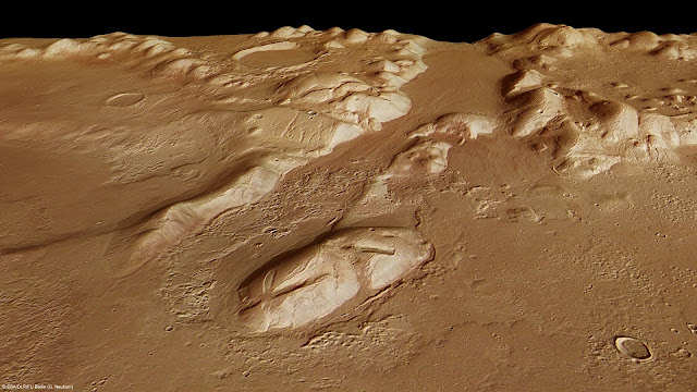
PHLEGRA MONTES PHOTOGRAPHED BY ESA MARS EXPRESS MISSION


MARS EXPRESS MISSION ( 2004-2022) Phlegra Montes (1,4km - 870 mi) Mars (Solar system)

ESA MARS EXPRESS MISSION ( 2004-2022)
Phlegra Montes (1,4km - 870 mi)
Mars (Solar system)


About that image
The High-Resolution Stereo Camera on ESA’s Mars Express collected the data for these images on 1 June 2011 during orbit 9465. This perspective view has been calculated from the Digital Terrain Model derived from the stereo channels.
Courtesey ESA/DLR/FU Berlin (G. Neukum),CC BY-SA 3.0 IGO


The mountains
The Phlegra Montes are a system of eroded Hesperian–Noachian-aged massifs and knobby terrain in the mid-latitudes of the northern lowlands of Mars, extending northwards from the Elysium Rise towards Vastitas Borealis for nearly 1,400 km (870 mi). The mountain ranges separate the large plains provinces of Utopia Planitia (west) and Amazonis Planitia (east), and were named in the 1970s after a classical albedo feature. The massif terrains are flanked by numerous parallel wrinkle ridges known as the Phlegra Dorsa. The mountain ranges were first mapped against imagery taken during NASA's Viking program in the 1970s, and the area is thought to have been uplifted due to regional-scale compressive stresses caused by the contemporary formations of the Elysium and Tharsis volcanic provinces. Recent research has unveiled the presence of extensive thrust faulting bounding the massif terrains. Since the 2010s, researchers have proposed the presence of a significant late Amazonian glaciation event along the Martian northern mid-latitudes, citing the presence of lineated valley fills, lobate debris aprons, and concentric crater fills. The presence of ring mold craters imply that significant stores of water ice may continue to persist in these terrains. Features interpreted as eskers have been observed in the southern Phlegra Montes. However, whether this glaciation was localized or of regional scale remains subject to debate in the scientific community.

About the mission
Mars Express is a space exploration mission being conducted by the European Space Agency (ESA). The Mars Express mission is exploring the planet Mars, and is the first planetary mission attempted by the agency. "Express" originally referred to the speed and efficiency with which the spacecraft was designed and built.However, "Express" also describes the spacecraft's relatively short interplanetary voyage, a result of being launched when the orbits of Earth and Mars brought them closer than they had been in about 60,000 years. Mars Express consists of two parts, the Mars Express Orbiter and Beagle 2, a lander designed to perform exobiology and geochemistry research. Although the lander failed to fully deploy after it landed on the Martian surface, the orbiter has been successfully performing scientific measurements since early 2004, namely, high-resolution imaging and mineralogical mapping of the surface, radar sounding of the subsurface structure down to the permafrost, precise determination of the atmospheric circulation and composition, and study of the interaction of the atmosphere with the interplanetary medium. Due to the valuable science return and the highly flexible mission profile, Mars Express has been granted several mission extensions. The latest was approved on 1 October 2020 and runs until 31 December 2022. Some of the instruments on the orbiter, including the camera systems and some spectrometers, reuse designs from the failed launch of the Russian Mars 96 mission in 1996 (European countries had provided much of the instrumentation and financing for that unsuccessful mission). The design of Mars Express is based on ESA's Rosetta mission, on which a considerable sum was spent on development. The same design was also used for ESA's Venus Express mission in order to increase reliability and reduce development cost and time. Because of these redesigns and repurposings, the total cost of the project was about $345 million- less than half of comparable U.S. missions. Arriving at Mars in 2003, 18 years, 9 months and 10 days ago (and counting), it is the second longest surviving, continually active spacecraft in orbit around a planet other than Earth, behind only NASA's still active 2001 Mars Odyssey.

______________________________
2022- Wandering Vertexes
A blog by Francis Rousseau