google.com, pub-0288379932320714, DIRECT, f08c47fec0942fa0 GRAVIR LES MONTAGNES... EN PEINTURE

Monday, November 12, 2018

CERRO RORAIMA BY CHARLES BARRINGTON BROWN


CHARLES BARRINGTON BROWN (1839 -1917)
 Cerro Roraima (2,810 m- 9,220 ft)
Brazil, Venezuela, Guyana border 

In Tepuy Roraima, lithograph, 1870,  British Library 

The mountain 
 Cerro Roraima (2,810m- 9,220ft) or  Tepuy Roraima  is the highest of the Pakaraima chain of Tepui plateaus in South America. First described by the English explorer Sir Walter Raleigh during his 1595 expedition, its 31-square-kilometre (12-square-mile) summit area is bounded on all sides by cliffs rising 400 metres (1,300 ft). The mountain also serves as the tripoint of Venezuela, Guyana and Brazil. Mount Roraima lies on the Guiana Shield in the southeastern corner of Venezuela's 30,000-square-kilometre (12,000-square-mile) Canaima National Park forming the highest peak of Guyana's Highland Range.
The highest point in Guyana and the highest point of the Brazilian state of Roraima lie on the plateau, but Venezuela and Brazil have higher mountains elsewhere. The triple border point is at 5°12′08″N 60°44′07″W,[6] but the mountain's highest point is Maverick Rock or Maverick Stone, at the southern end of the plateau and wholly within Venezuela.

The artist 
Charles Barrington Brown (1839 -1917) is a Canadian geologist and explorer. He studied at Harvard University and the Royal School of Mines. In 1869 and 1872, it took up to 17 days from British Guiana to reach Mount Roraima on the border with Brazil and Venezuela. He is the first to describe the Tök-Wasen, a monolith located at the southern end of the mountain, and to suggest the ascent by a balloon. He is also the discoverer of Kaieteur Falls on the Potaro, a tributary of Essequibo, on April 24, 1870, and New River Springs in 1871.
_______________________________
2018 - Wandering Vertexes...
by Francis Rousseau 

Sunday, November 11, 2018

POPOCATEPETL & IZTACCIHUATL (2) PAINTED BYJOSE MARIA VELASCO

http://wanderingvertexes.blogspot.com


JOSE MARIA VELASCO (1840-1912)
 Popocatépetl (5, 426 m -17, 802 ft) on right
Iztaccíhuatl (5,230 m - 17,160 ft) (on left)
Mexico

 In  The volcanic peaks Popocatepetl and Iztacchihuatl  With a View of Mexico City, oil on canvas, 1880,
 Other paintings by Velasco representing those volcanoes in this blog

The volcanoes 
Popocatépetl  (5,426 m (17,802 ft),  on right in this painting,  is an active volcano, located in the states of Puebla, Mexico, and Morelos, in Central Mexico, and lies in the eastern half of the Trans-Mexican volcanic belt.  The name Popocatépetl comes from the Nahuatl words Popōca   (It smokes) and Tepētl  (mountain), meaning Smoking Mountain. It is the second highest peak in Mexico, after Citlaltépetl (Pico de Orizaba) at 5,636 m (18,491 ft).
It is linked to the Iztaccihuatl volcano to the north by the high saddle known as the Paso de Cortés.
Popocatépetl is 70 km (43 mi) southeast of Mexico City, from where it can be seen regularly, depending on atmospheric conditions. Until recently, the volcano was one of three tall peaks in Mexico to contain glaciers, the others being Iztaccihuatl and Pico de Orizaba. 
Iztaccíhuatl  (5,230 m - 17,160 ft) is  dormant volcanic mountain in Mexico located on the border between the State of Mexico and Puebla. It is the nation's third highest, after Pico de Orizaba 5,636 m (18,491 ft) and Popocatépetl 5,426 m (17,802 ft). The name "Iztaccíhuatl" is Nahuatl for "White woman", reflecting the four individual snow-capped peaks which depict the head, chest, knees and feet of a sleeping female when seen from east or west.The peak is sometimes nicknamed La Mujer Dormida ("The Sleeping Woman".)  Iztaccíhuatl is to the north of Popocatépetl, to which it is connected by the high altitude Paso de Cortés. Depending on atmospheric conditions Iztaccíhuatl is also visible much of the year from Mexico City some 70 km (43 mi) to the northwest.
The first recorded ascent was made in 1889, though archaeological evidence suggests the Aztecs and previous cultures climbed it previously. It is the lowest peak containing permanent snow and glaciers in Mexico.
In Aztec mythology : Iztaccíhuatl was a princess who fell in love with one of her father's warriors, Popocatépetl. The emperor sent Popocatépetl to war in Oaxaca, promising him Iztaccíhuatl as his wife when he returned (which Iztaccíhuatl's father presumed he would not). Iztaccíhuatl was falsely told that Popocatépetl had died in battle, and believing the news, she died of grief. When Popocatépetl returned to find his love dead, he took her body to a spot outside Tenochtitlan and kneeled by her grave. The gods covered them with snow and changed them into mountains. 
Popocatépetl became an active volcano, raining fire on Earth in blind rage at the loss of his beloved.

The Painter 
José Maria Tranquilino Francisco de Jesus Velasco Gomez Obregуn, generally known as José Marнa Velasco, was a 19th-century Mexican polymath, most famous as a painter who made Mexican geography a symbol of national identity through his paintings. He was both one of the most popular artists of the time and internationally renowned. He received many distinctions such as the gold medal of the Mexican National Expositions of Bellas Artes in 1874 and 1876; the gold medal of the Philadelphia International Exposition in 1876, on the centenary of U.S. independence; and the medal of the Paris Universal Exposition in 1889, on the centenary of the outbreak of the French Revolution. His painting El valle de Mexico is considered Velasco's masterpiece, of which he created seven different renditions. Of all the nineteenth-century painters, Velasco was the "first to be elevated in the post-Revolutionary period as an exemplar of nationalism."
Velasco's long career elevated Mexican landscape painting to international standing. One of his landscapes of the Valley of Mexico is in the Vatican Museum, a gift to Pope Leo XIII. His scenes of the Mexican landscape are a visual source for environmental historians, since they show the Valley of Mexico before its degradation in the twentieth century, with air pollution and urban sprawl. His landscape art has a wide appeal, since it is more accessible than history paintings that require the viewer to understand a particular event.
Today the Government of the State of Mexico, where Velasco was from, presents an award for artistic merit in his name to painters born in that state. Among the most outstanding winners are Luis Nishizawa, Leopoldo Flores, Ignacio Barrios and Héctor Cruz.
The José María Velasco Museum was opened in 1992 in Toluca City with the task of preserving and promoting his paintings.

_______________________________

2018 - Wandering Vertexes...
by Francis Rousseau 

Saturday, November 10, 2018

MOUNT EREBUS (2) BY EDWARD ADRIAN WILSON

http://wanderingvertexes.blogspot.com

EDWARD ADRIAN WILSON (1872-1912) 
Mount Erebus (3, 794 m - 12, 448ft)
Antarctica

In Mount Erebus in the dark, 1911 watercolour,  Royal Geographical Society, London


The mountain 
Mount Erebus (3, 794 m - 12, 448ft), not to be confused with Mount Elbrus is the second-highest volcano in Antarctica (after Mount Sidley) and the southernmost active volcano on Earth. It is the sixth highest ultra mountain on an island, located on Ross Island, which is also home to three inactive volcanoes:  Mount Terror, Mount Bird, and Mount Terra Nova.
The volcano has been active since c. 1.3 million years ago and is the site of the Mount Erebus Volcano Observatory run by the New Mexico Institute of Mining and Technology.
Mount Erebus was discovered on January 27, 1841 (and observed to be in eruption) by polar explorer Sir James Clark Ross who named it and its companion, Mount Terror, after his ships, Erebus and Terror (which were later used by Sir John Franklin on his disastrous Arctic expedition). Erebus is a dark region in Hades in Greek mythology. Present with Ross on the Erebus was the young Joseph Hooker, future president of the Royal Society and close friend of Charles Darwin. Erebus was an Ancient Greek primordial deity of darkness, the son of Chaos.
Mount Erebus is classified as a polygenetic stratovolcano. The bottom half of the volcano is a shield and the top half is a stratocone. The composition of the current eruptive products of Erebus is anorthoclase-porphyritic tephritic phonolite and phonolite, which are the bulk of exposed lava flow on the volcano.  Erebus is the world's only presently erupting phonolite volcano.

The artist
Edward Adrian Wilson,  nicknamed "Uncle Bill" was an English physician, polar explorer, natural historian, painter and ornithologist. Wilson took part in two British expeditions to Antarctica, the Discovery Expedition (1901-1904)  and the tragic Terra Nova Expedition (1907-1912), both under the leadership of Scott.
Dr. Edward A. Wilson  is widely regarded as one of the finest artists ever to have worked in the Antarctic. Sailing with Captain Scott aboard 'Discovery' (1901-1904), he became the last in a long tradition of 'exploration artists' from an age when pencil and watercolour were the main methods of producing accurate scientific records of new lands and animal species. He combined scientific, topographical and landscape techniques to produce accurate and beautiful images of the last unknown continent. Such was the strength of his work that it also helped to found the tradition of modern wildlife painting. In particular Wilson captured the essence of the flight and motion of Southern Ocean sea-birds on paper.
Returning with Captain Scott aboard 'Terra Nova' (1910-1913) as Chief of Scientific Staff, he continued to record the continent and its wildlife with extraordinary deftness. Chosen to accompany Captain Scott to the South Pole, his last drawings are from one of the most famous epic journeys in exploration history. Along with his scientific work, Wilson's pencil recorded the finding of Roald Amundsen's tent at the South Pole by Captain Scott. Wilson died, along with the other members of the British Pole Party, during the return journey, in March 1912. The drawings and paintings were created at considerable personal cost in the freezing conditions in which Wilson worked. He often suffered severely from the cold whilst sketching and also from snow-blindness, or sunburn of the eye. They provide a remarkable testament to one of the great figures of the heroic age of Antarctic exploration. The book has been produced as a companion volume to 'Edward Wilson's Nature Notebooks' by two of Wilson's great nephews, to mark the centenary of his death.
_______________________________
2018 - Wandering Vertexes..
Un blog de Francis Rousseau

Friday, November 9, 2018

DIAMON HEAD PAINTED BY CHARLES FURNEAUX


 CHARLES FURNEAUX (1835-1913
Diamond Head  (282 m - 925 ft)
United States of America (Hawaï)

1. In  Diamond Head, Waikiki beach,   oil on canvas,  1880, Private collection 
2.  Waikiki with a view of Diamond Head, oil on canvas, c. 1885, Private collection 


The volcano 
Diamond Head   (282 m - 925 ft) in Hawaiian Lē'ahi  (the tuna promontory) is a crater shaped like ring of tuff about 1.2 kilometers  diameter,  on the island of Oahu, in the archipelago of Hawaii, in United States of America. The Diamond head figure, characteristic of Honolulu, is traditionally used as an indication of direction as opposed to Ewa, located on the west coast of the island.
Diamond Head is so called,  because of the first British sailors who took calcite crystals for diamonds. Diamond Head is a funboard spot on the island of Oahu in Hawaii.

The painter 
Charles Furneaux was born in Boston and became a drawing instructor in that area. For many years he lived in the town of Melrose, Massachusetts. In 1880, Furneaux moved to Hawaii, where he cultivated the friendship of King Kalakaua and other members of the Hawaiian royal family, from whom he later received several commissions. In the late 1880s, he was commissioned in Honolulu by Alexander Joy Cartwright, widely credited as the "father of baseball" and another dear friend of King Kalakaua, to paint the only oil portrait of his 72-year life. While living in Honolulu he taught at the private schools Punahou and St. Albans (now known as Iolani School). In 1885, he received the order of Chevalier of Kapiolani from King Kalakaua in 'recognition of his services in advancing Hawaiian art'. He died in Hawaii in 1913.
His reputation is mainly based on the paintings he executed in Hawaii, especially those of erupting volcanoes. The Bishop Museum (Honolulu), the Brooklyn Museum, the Honolulu Museum of Art, Iolani Palace (Honolulu) and Mount Holyoke College Art Museum (South Hadley, Massachusetts) are among the public collections holding works by Charles Furneaux.

_______________________________

2018 - Wandering Vertexes...
by Francis Rousseau 

Thursday, November 8, 2018

MONTE DURANNO BY CARL HUMMEL

 http://wanderingvertexes.blogspot.com

Carl Hummel (1821-1907)
Monte Duranno  (2,652 m - 8, 700 ft) 
Italy 

In Ansicht von Pieve di Cadore, oil on canvas,  (130 x 180 cm), 1902, Private collection  

The mountain 
Mount Duranno  (2,652 m - 8, 700 ft)  is a mountain in the Friulian Dolomites, more precisely called the Dolomiti d 'Oltre Piave , in the Carnic Prealps in Italy . It is located between the Veneto (province of Belluno) and in Friuli-Venezia Giulia (province of Pordenone). It is a mountain of the Cima dei Preti Group -Duranno, partly included in the natural park of the Friulian Dolomites. One can climb the mountain from the Maniago refuge.

The painter

The german landcape painter and etcher Carl Maria Nicolaus Hummel was the son of Austrian composer Johann Nepomuk Hummel and the opera singer Elisabeth Röckel. His studies began in 1841 under Friedrich Preller at the Fürstliche freie Zeichenschule Weimar. After graduating, he made several study trips to England, Norway, Rügen and the Tyrol, lingering in Italy and Sicily until 1846. Upon his return, he settled in Weimar, where he became a professor at the Weimar Saxon-Grand Ducal Art School in 1860. His paintings focus primarily on the Italian and Tyrolean Alps. They are widely displayed at museums throughout Northern Europe, including the Musée de la Vie Romantique in Paris.

_______________________________
2018 - Wandering Vertexes...
by Francis Rousseau 

Wednesday, November 7, 2018

MONS VINOGRADOV BY NASA APOLLO 17 MISSION


http://wanderingvertexes.blogspot.com

NASA APOLLO 17 MISSION ( 1972) 
Mons Vinogradov  (1, 400 m  / 1, 4 km - 4, 593ft / 0,86 mi)
The Moon 

 In Mons Vinogradov seen  from Apollo 17 spaceship during the Moon approach, 1972, Arizona State University, 
Apollo Image Archive

The mountain 
Mons Vinogradov  (1, 400 m  / 1, 4 km - 4, 593ft / 0,86 mi) is a rugged massif that is located on the lunar mare where Oceanus Procellarum to the southwest joins Mare Imbrium to the east. There are three primary peaks in this formation, which rise to altitudes of 1.0–1.4 km above the surface. To the east of this rise is the crater Euler, and to the southeast is an area of rugged ground that reaches the Montes Carpatus range. The Carpatus mountain range forms the southwest boundary of the Mare Imbrium.
The selenographic coordinate of Mons Vinogradov is 22.4 N, 32.4 W, and it has a maximum diameter of 25 km at the base. It was named after Aleksandr P. Vinogradov. This mountain was formerly named Euler Beta (β), or Mons Euler.
In the rugged ground just to the southeast of this mountain is a set of tiny craters that have been assigned names by the IAU. These are listed in the table below.

The mission
Apollo 17 was the final mission of NASA's Apollo program.
Launched at 12:33 a.m. Eastern Standard Time (EST) on December 7, 1972, with a crew made up of Commander Eugene Cernan, Command Module Pilot Ronald Evans, and Lunar Module Pilot Harrison Schmitt, it was the last use of Apollo hardware for its original purpose; after Apollo 17, extra Apollo spacecraft were used in the Skylab and Apollo–Soyuz programs.
Apollo 17 was the first night launch of a U.S. human spaceflight and the final manned launch of a Saturn V rocket. It was a "J-type mission" which included three days on the lunar surface, extended scientific capability, and the third Lunar Roving Vehicle (LRV). While Evans remained in lunar orbit in the Command/Service Module (CSM), Cernan and Schmitt spent just over three days on the Moon in the Taurus–Littrow valley and completed three moonwalks, taking lunar samples and deploying scientific instruments. Evans took scientific measurements and photographs from orbit using a Scientific Instruments Module mounted in the Service Module.
The landing site was chosen with the primary objectives of Apollo 17 in mind: to sample lunar highland material older than the impact that formed Mare Imbrium, and investigate the possibility of relatively new volcanic activity in the same area.  Cernan, Evans and Schmitt returned to Earth on December 19 after a 12-day mission.
Apollo 17 is the most recent manned Moon landing and the most recent time humans travelled beyond low Earth orbit.  It was also the first mission to have no one on board who had been a test pilot; X-15 test pilot Joe Engle lost the lunar module pilot assignment to Schmitt, a scientist. 
The mission broke several records: the longest moon landing, longest total extravehicular activities (moonwalks),  largest lunar sample, and longest time in lunar orbit.
_______________________________
2018 - Wandering Vertexes...
by Francis Rousseau 

Tuesday, November 6, 2018

PUEBLO PEAK BY AKSELI GALLEN-KALLELA


AKSELI GALLEN KALLELA  (1865-1931)
Pueblo Peak  (2,631m - 8,632ft)
United States of America (Oregon / Nevada) 

In  Taos Mountains covered by clouds  (Taos vuoret pilvien peitossa), oil on canvas, 1924. Kansallisgalleria 

The mountain 
Pueblo Peak (2,631m - 8,632ft) to Pueblo Mountain is the highest point of the Pueblo Mountains, a remote mountain range in the United States located mostly in southeastern Oregon and partially in northwestern Nevada. Most land in the Pueblo Mountains is managed by the federal Bureau of Land Management.
While there is no designated wilderness area in the Pueblo Mountains, traveling in the mountains can be very challenging. The Desert Trail runs through the mountains; however, it is not a developed hiking trail. The route is simply marked by rock cairns that serve as guideposts. The cairns were built as a cooperative venture between the Bureau of Land Management, the Oregon Parks and Recreation Department, and the Desert Trail Association (a private organization). The Desert Trail Association publishes a topographic map for hikers that gives directions for orienteering from cairn to cairn.
Cattle and sheep grazing in the Pueblo Mountains began when the first ranches were established along the eastern edge of the mountains in the mid-1860s.
Miners were among the first to explore the Pueblo Mountains. There are at least 18 locations where mining took place in the past.
Wind power is now being explored in the Pueblo Mountains. The test allowed a private wind energy company to install, operate, and maintain two meteorological poles.

The painter 
Akseli Gallen-Kallela was a Swedish-speaking Finnish painter who is best known for his illustrations of the Kalevala, the Finnish national epic. His work was considered very important for the Finnish national identity. He changed his name from Gallen to Gallen-Kallela in 1907. In 1884 he moved to Paris, to study at the Académie Julian and became friends with the Finnish painter Albert Edelfelt, the Norwegian painter Adam Dörnberger, and the Swedish writer August Strindberg.
In December 1894, Gallen-Kallela moved to Berlin to oversee the joint exhibition of his works with the works of Norwegian painter Edvard Munch. Here he became acquainted with the Symbolists.
On his return from Germany, Gallen studied print-making and visited London to deepen his knowledge, and in 1898 studied fresco-painting in Italy.
For the Paris World Fair in 1900, Gallen-Kallela painted frescoes for the Finnish Pavilion. In these frescoes, his political ideas became most apparent.Gallen-Kallela officially finnicized his name to the more Finnish-sounding Akseli Gallen-Kallela in 1907.
In 1909, Gallen-Kallela moved to Nairobi in Kenya with his family, and there he painted over 150 expressionist oil paintings and bought many east African artefacts. But he returned to Finland after a couple of years, because he realized Finland was his main inspiration. Between 1911 and 1913 he designed and built a studio and house at Tarvaspää, about 10 km northwest of the centre of Helsinki.
From December 1923 to May 1926, Gallen-Kallela lived in the United States, where an exhibition of his work toured several cities, and where he visited the Taos art-colony in New Mexico to study indigenous American art. In 1925 he began the illustrations for his "Great Kalevala". This was still unfinished when he died of pneumonia in Stockholm on 7 March 1931, while returning from a lecture in Copenhagen, Denmark
His studio and house at Tarvaspää was opened as the Gallen-Kallela Museum in 1961

_______________________________
2018 - Wandering Vertexes...
by Francis Rousseau 

Monday, November 5, 2018

MOUNT EMIN PHOGRAPHED IN 1906 BY VITTORIO SELLA


VITTORIO SELLA (1859-1943) 

Mount Emin (4,798 m -  15,741 ft) 
 Congo - Uganda border 

In Mt Emin seen from the Iolanda Glacier, photo  from the book  Ruwenzori-Africa,  1908 published by Dutton and Company - New York 


The mountain Mount Emin (4,798 m -  15,741 ft)  is one of the six mountains in the Ruwenzori mountain range and is located in Congo-Kinshasa on the border with Uganda. Emin and Mount Gessi , located in Uganda east of the border, are located on either side of a long narrow valley running north-south. Emin has two peaks called Umberto (4 798 meters) and Kraepelin (4 791 meters). The mountain forms a rocky north-south hill with the higher peak at the southern end. Like Gessi, Emin is north of the triangle formed by the tops of Stanleys , Spekes , and Bakers. Its ascent  was completed in 1906  by Luigi Amedo di Savoia, J. Petigax and L Petigax. The photo aboce is dating from this period The photographerVittorio Sella is a mountain italian climber and photographer who took his passion for mountains from his uncle, Quintino Sella, founder of the Italian Alpine Club.  He accomplished many remarkable climbs in the Alps, the first wintering in the Matterhorn and Mount Rose (1882) and the first winter crossing of Mont Blanc (1888).He took part in various expeditions outside Italy:- Three in the Caucasus in 1889, 1890 and 1896 where a summit still bears his name;- The ascent of Mount Saint Elias in Alaska in 1897- Sikkim and Nepal in 1899- Possibly climb Mount Stanley in Uganda in 1906 during an expedition to the Rwenzori- Recognition at K2  and Mustagh Tower in 1909- In Morocco in 1925.During expeditions in Alaska, Uganda and Karakoram (K2-Chogolisa), he accompanied the Duke of Abruzzi, Prince Luigi Amedeo di Savoia.Sella continues the practice of climbing into his old age, completing his final attempt in the Matterhorn at the age of 76; a climb he had to interrupt the rise following an accident in which one of his guides injured. He died in his hometown during World War II.  His photographic collection is now managed by the Sella Foundation.His photos mountain are still  considered today to be among the finest ever made.Jim Curran believes that "Sella remains probably the greatest photographer of the mountain.  His name is synonymous with technical perfection and aesthetic refinement. "The quality of the pictures of Vittorio Sella is partly explained by the use of a view camera 30 × 40 cm, despite the difficulty of the transportation of such a device, both heavy and fragile in places inaccessible; to be able to transport it safely, he had to make special pieces that can be stored in saddle bags.  His photographs have been widely distributed, either through the press or in the galleries, and were unanimously celebrated; Ansel Adams, who was able to admire thirty-one in an exhibition that was organized at Sella American Sierra Club, said they inspired him "a religious kind of sense of wonder."  Many of his pictures were taken in the mountains for the very first time in the History, which give them a much artistic, historical  but also scientific value ; for example, one could measure the decline in the Rwenzori glaciers in Central Africa._______________________________
2018 - Wandering Vertexes...
by Francis Rousseau 

Sunday, November 4, 2018

MOUNT ABRUPT BY EUGENE VON GUERARD


EUGENE VON GUERARD  (1811-1901)
Mount Abrupt (805 m - 2,641ft)
Australia  (Victoria) 

 In Mount Abrupt, The Crampians, Victoria, Private collection 

The mountain 
Mount Abrupt (805 m - 2,641ft) is located in Grampians National Park Victoria. This Mount Abrupt hike, suitable for fit and energetic walkers, can involve water crossings, slippery track surfaces, rock hopping and rock scrambling. The steep track winds its way through heathy woodland to a ridge. Follow the ridge over rock slabs and stunted montane vegetation to the summit, for one of the most spectacular views.
A large landside caused by the storm event in January 2011 badly damaged this walking track. Parks Victoria has worked hard to rebuild this track but further rain could cause movement of soil and rock over the track.

The painter 
Johann Joseph Eugene von Guerard was an Austrian-born artist, active in Australia from 1852 to 1882. Known for his finely detailed landscapes in the tradition of the Düsseldorf school of painting, he is represented in Australia's major public galleries, and is referred to in the country as Eugene von Guerard. In 1852 von Guerard arrived in Victoria, Australia, determined to try his luck on the Victorian goldfields. As a gold-digger he was not very successful, but he did produce a large number of intimate studies of goldfields life, quite different from the deliberately awe-inspiring landscapes for which he was later to become famous. Realizing that there were opportunities for an artist in Australia, he abandoned the diggings and was soon undertaking commissions recording the dwellings and properties of wealthy pastoralists.
By the early 1860s, von Guerard was recognized as the foremost landscape artist in the colonies, touring Southeast Australia and New Zealand in pursuit of the sublime and the picturesque.  He is most known for the wilderness paintings produced during this time, which are remarkable for their shadowy lighting and fastidious detail.  Indeed, his View of Tower Hill in south-western Victoria was used as a botanical template over a century later when the land, which had been laid waste and polluted by agriculture, was systematically reclaimed, forested with native flora and made a state park. The scientific accuracy of such work has led to a reassessment of von Guerard's approach to wilderness painting, and some historians believe it likely that the landscapist was strongly influenced by the environmental theories of the leading scientist Alexander von Humboldt. Others attribute his 'truthful representation' of nature to the criterion for figure and landscape painting set by the Düsseldorf Academy.
_______________________________
2018 - Wandering Vertexes...


by Francis Rousseau 

Saturday, November 3, 2018

GERLACHOVSKY STIT BY STANISLAW GALEK

http://wanderingvertexes.blogspot.com

STANISLAW GALEK (1876-1961)
Gechovský štít (2,654 m - 8,709 ft)
Slovakia- Poland

  In Turnie tatrzanskie, watercolor, Private collection 


The mountain 
 Gerlachovský štít (2,654 m - 8,709 ft), Gerlach Peak in english, is the highest peak in the High Tatras, in Slovakia, and in the whole 1,500 km (930 mi) long Carpathian mountain chain. The pyramidal shape of the massif is marked by a huge cirque. Despite its relatively low elevation, the about 2,000 m vertical rise from the valley floor makes Gerlachovský štít  soar. Mistaken for an average mountain in the rugged High Tatras range in the more distant past, it has since played a symbolic role in the eyes of the rulers and populations of several Central European nations, to the point that between the 19th and mid-20th century, it had four different names with six name reversals. It managed to be the highest mountain of the Kingdom of Hungary, and of the countries of Czechoslovakia and Slovakia within the span of only about two decades of the 20th century.
Gerlachovský štít  shares its geology and ecology with the rest of the High Tatras, but provides a worthwhile environment for biologists as the highest ground anywhere in Europe north of the parallel linking approximately Munich, Salzburg, and Vienna. With the travel restrictions imposed by the Eastern Bloc, the mountain was particularly treasured as the loftiest point available to climb to by Czechs, East Germans, Hungarians, Poles, and Slovaks. It continues to attract its share of visitors although the local authorities have been continually adding new restrictions on access.

The painter 
Stanisław Gałek was a Polish painter and sculptor, and... designer of kilims. In 1896 he graduated from the Vocational School of Wood Industry in Zakopane and then taught in it a drawing, being an assistant to Edgar Kováts . In 1899 he began studies at the Krakow Academy of Fine Arts in the studios of Jacek Malczewski and Jan Stanisławski. A year later, he stopped studying in Kraków and left for Munich , where he began studying at Königliche Kunstgewerbeschule.
Later, he studied at the Paris École Nationale des Beaux-Arts in the studio of Jean-Léon Gérôme.
In 1910, he left to create in Italy and the Crimea . In 1912 he received the work of a drawing teacher at a vocational school in Kołomyja, from where he returned to Zakopane in 1916 and again began to teach at the School of Wood Industry.
From 1931, he devoted himself only to painting.
 He exhibited his works for the first time in 1900, he was a regular participant in exhibitions organized by the Krakow Society of Friends of Fine Arts and from 1907 by the Society for the Encouragement of Fine Arts. He took part in an international exhibition organized in 1910 in Berlin, and in 1929 in the Poznań Universal National Exhibition. In 1930 he exhibited in Budapest and Vienna.  In 1960, the Warsaw Zachęta exhibition hosted an individual jubilee exhibition showing the full artistic output of Stanisław Gałek. He was one of the most outstanding painters showing the Tatras , especially the area around Morskie Oko.
In addition, he carved and designed patterns of kilims for the Kilim association in Zakopane.

_______________________________
2018 - Wandering Vertexes...
Un blog de Francis Rousseau

Friday, November 2, 2018

FUJIYAMA BY EVE DREWELOWE

 http://wanderingvertexes.blogspot.com

EVE DREWELOWE (1899-1988)
Fujiyama / 富士山 (3, 776 m -12,389 ft)
Japan

 In Mont Fuji from the lake Hakone, 1928, Drawing , University of Iowa school of art and history 

The mountain 
Mount Fuji or Fujiyama (富士山)  (3,776 m - 12,389 ft) is the highest mountain peak in Japan, located on Honshu Island. Several names are attributed to it: "Fuji-san", "Fujiyama" or, redundantly, "Mt. Fujiyama". Usually Japanese speakers refer to the mountain as "Fuji-san".  The other Japanese names for Mount Fuji,  have become obsolete or poetic like: Fuji-no-Yama (The Mountain of Fuji), Fuji-no-Takane (The High Peak of Fuji), Fuyō-hō (The Lotus Peak), and Fugaku...
Mount Fuji is an active stratovolcano that last erupted in 1707–08. Mount Fuji lies about 100 kilometres (60 mi) south-west of Tokyo, and can be seen from there on a clear day.
Mount Fuji's exceptionally symmetrical cone, which is snow-capped several months a year, is a well-known symbol of Japan and it is frequently depicted in art and photographs, as well as visited by sightseers and climbers.
Mount Fuji is one of Japan's Three Holy Mountains along with Mount Tate and Mount Haku. It is also a Special Place of Scenic Beauty and one of Japan's Historic Sites.
It was added to the World Heritage List as a Cultural Site on June 22, 2013. As per UNESCO, Mount Fuji has “inspired artists and poets and been the object of pilgrimage for centuries”. 
UNESCO recognizes 25 sites of cultural interest within the Mt. Fuji locality. 

The painter 
 Eve Drewelowe was an American painter. Her career spanned six decades and produced more than 1,000 works of art in oil, watercolor, pen and ink and other media in styles that included impressionism, social realism and abstraction.
Despite dabbling with other artistic styles, Drewelowe always showed an inclination toward landscapes.  She once said: “my waking thought from an embryo on was my need to be an artist.” 
Though never known to have used the word to describe herself, Eve Drewelowe is often considered a feminist artist. Her personal life exhibited feminist themes: the artist retained her maiden name and publicly stated a disinterest in housework and parenting. Drewelowe chose not to take her husband’s last name because in her opinion it should not matter to others whether she is married or not. When Drewelowe and Van Ek returned from their travels and started building a house together.  She did not want to be involved in the pleasantries of being the dean’s wife, especially hosting dinner parties, so she specified to have the house built lacking a dining room.  She always maintained that she did not want to have children of her own, much to her mother’s dismay.
Although Drewelowe is mainly renowned in Colorado and Iowa, she had solo exhibitions all over the country. Her work was shown at National Association of Women Artists exhibitions, the Art Institute of Chicago, the Denver Art Museum, the National Museum of Women in the Arts and numerous other esteemed institutions. Although women had been in the profession of art for 20–30 years at the beginning of Drewelowe’s career, she still faced opposition and sexism. Critics believe that she could have been much more acclaimed had she not been a woman and had she not fallen ill at the peak of her career. Others believe that her “reincarnation” and transition to abstract paintings increased Drewelowe’s popularity as an artist by keeping her relevant in an evolving artistic world.

_______________________________
2018 - Wandering Vertexes...
by Francis Rousseau 


Thursday, November 1, 2018

NORTHCAPE PAINTED BY THOROLF HOLMBOE


http://wanderingvertexes.blogspot.com

THOROLF HOLMBOE (1866-1935) 
North Cape (307m - 1,007 ft)
Norway

In Midnight Sun at the North Cap, oil on canvas

The cliff 
North Cape (307m - 1,007 ft), Nordkapp in  Norwegian, named by the Englishman Steven Borough, captain of the Edward Bonaventure, which sailed past in 1553 in search of the Northeast Passage, is a cape on the northern coast of the island of Magerшya in Northern Norway. The cape is in Nordkapp Municipality in Finnmark county, Norway. The European route E69 highway has its northern terminus at North Cape, since it is a popular tourist attraction. The cape includes a 307 metres (1,007 ft) high cliff with a large flat plateau on top where visitors can stand and watch the midnight sun or the views of the Barents Sea to the north.
The North Cape is the point where the Norwegian Sea, part of the Atlantic Ocean, meets the Barents Sea, part of the Arctic Ocean. The midnight sun can be seen from 14 May to the 31st of July.
During winter season, it is also possible to visit North Cape, however the last stretch of road is only open for convoy driving at fixed hours. The road all the way through Norway up to North Cape is kept open during winter and is accessible to regular vehicles with some specific winter precautions being required to deal with the hard snow and wind conditions that may occur in winter.
Before this, E69 was the only winter closed E road in Europe.

The painter 
Thorolf Holmboe (10 May 1866 – 8 March 1935) was a Norwegian painter, illustrator and designer.
He was born in Vefsn, in Nordland county. He studied under Hans Gude in Berlin between 1886 and 1887 and Fernand Cormon in Paris between 1889 and 1891. He was inspired by many different styles at different points in his career, including Naturalism, Neo-romanticism, Realism and Impressionism. He is represented with thirteen works in the National Gallery of Norway.

____________________________________________
2018 - Wandering Vertexes...
by Francis Rousseau 


Wednesday, October 31, 2018

EL CHIMBORAZO PAINTED BY RAFAEL SALAS


http://wanderingvertexes.blogspot.com

RAFAEL SALAS (1824-1906),
El Chimborazo (6,263 m -20,548 ft)  
Ecuador 

In View of Chimborazo, oil on canvas, 1890,  Museo de Arte del Banco de la Republica, Bogota.

The mountain
Chimborazo  (6,263 m -20,548 ft) is a currently inactive stratovolcano in the Cordillera Occidental range of the Andes ans the highest mountain in Ecuador and the Andes north of Peru ; it is higher than any more northerly summit in the Americas. Chimborazo is not the highest mountain by elevation above sea level, but its location along the equatorial bulge makes its summit the farthest point on the Earth's surface from the Earth's center.
Chimborazo is at the main end of the Ecuadorian Volcanic Arc, north west of the town of Riobamba. Chimborazo is in la Avenida de los Volcanes (the Avenue of Volcanoes) west of the Sanancajas mountain chain. Carihuairazo, Tungurahua, Tulabug, and El Altar are all mountains that neighbor Chimborazo.  The closest mountain peak, Carihuairazo, is 5.8 mi (9.3 km) from Chimborazo. There are many microclimates near Chimborazo, varying from desert in the Arenal to the humid mountains in the Abraspungo valley.
Its last known eruption is believed to have occurred around A.D. 550.
Until the beginning of the 19th century, it was thought that Chimborazo was the highest mountain on Earth (measured from sea level), and such reputation led to many attempts on its summit during the 17th and 18th centuries.
In 1746, the volcano was explored by French academicians from the  French Geodesic Mission. Their mission was to determine the sphericity of the Earth. Their work along with another team in Lapland established that the Earth was an oblate spheroid rather than a true sphere. They did not reach the summit of Chimborazo.
In 1802, during his expedition to South America, Baron Alexander von Humboldt, accompanied by Aimé Bonpland and the Ecuadorian Carlos Montufar, tried to reach the summit. From his description of the mountain, it seems that before he and his companions had to return suffering from altitude sickness they reached a point at 5,875 m, higher than previously attained by any European in recorded history. (Incans had reached much higher altitudes previously; see Llullaillaco). In 1831, Jean-Baptiste Boussingault and Colonel Hall reached a new "highest point", estimated to be 6,006 m.
On 4 January 1880, the English climber Edward Whymper reached the summit of Chimborazo.

The painter 
Rafael Salas was an important Ecuadorian  landscape and genre painter  of nineteenth century South America neoclassicism. He was the last son of the famous Salas artists dynasty among which  his  half brother Ramon Salas ( 1815-1880), the fist professor a t Academy of fine Arts of Quito and  responsive for the taste of Costumbrismo; and above all their father Antonio Salas (1795-1860) a colonial artist specialized in religious themes like La Muerte de San José and La Negacion de San Pedro in the Cathedral of Quito.

_______________________________
2018 - Wandering Vertexes
Un blog de Francis Rousseau 

Tuesday, October 30, 2018

MOUNT ASSINIBOINE BY HENRY JOSEPH BREUER


http://wanderingvertexes.blogspot.com

HENRY JOSEPH BREUER  (1860-1932) 
Mount Assiniboine (3,618m - 11,870ft) 
Canada (Alberta)

The mountain
Mount Assiniboine (3,618m - 11,870ft) also known as Assiniboine Mountain, is a pyramidal peak mountain located on the Great Divide, on the British Columbia/Alberta border in Canada.
It is the highest peak in the Southern Continental Ranges of the Canadian Rockies. Mt. Assiniboine rises nearly 1,525 m (5,003 ft) above Lake Magog. Because of its resemblance to the Matterhorn in the Alps, it is nicknamed the "Matterhorn of the Rockies". Mt. Assiniboine was named by George M. Dawson in 1885. When Dawson saw Mt. Assiniboine from Copper Mountain, he saw a plume of clouds trailing away from the top. This reminded him of the plumes of smoke emanating from the teepees of Assiniboine Indians. Mt. Assiniboine lies on the border between Mount Assiniboine Provincial Park, in British Columbia, and Banff National Park, in Alberta. The park does not have any roads and thus can only be reached by a six-hour hike 27 km (17 mi), three-hour bike ride (now disallowed to reduce human / grizzly encounters) or helicopter. The usual approach is via Bryant Creek. From Canmore follow the Smith-Dorien road to the Mount Shark parking lot. The trail is well signed. A helipad is also here.
Mt. Assiniboine was first climbed in 1901 by James Outram, Christian Bohren and Christian Hasler. In 1925, Lawrence Grassi became the first person to make a solo ascent. On August 27, 2001, Bohren's granddaughter Lonnie along with three others made a successful ascent, celebrating the 100th anniversary of the first ascent.

The painter 
Not to be  confused with the austrian physician, Joseph Breuer, Henry-Joseph Breuer, born in Philadelphia, Pennsylvania,  in 1860, is a american painter who earned a reputation as a well-known "painter of poetic landscapes."  He studied art during the 1870s in Buffalo, New York, and then worked as a designer-decorator for the Rockwood Pottery Company in Cincinnati where he also attended the Art Academy. He worked for five years as a lithographer in New York City. 

In 1888, he settled in San Francisco where he became art editor for the San Francisco Chronicle and Californian magazine. Then he went to France for art study and was influenced by the Barbizon School of impressionist painters of rural landscapes. 

Living out of a horse-drawn wagon, he traveled extensively along the western coast of California and Oregon, painting and earning a national reputation for his landscapes. He also painted in Arizona including Canyon de Chelly in Navajo country and did commissioned views of the San Gabriel Valley for the St. Louis Exposition in 1904.

In 1903 he spent two weeks in  Mount Shasta which had a great impact on him. In the Cincinatti  Time Stars he wrote:  " I board a train to some station somewhere near Mount Shasta,and this into the woods. I man a one- man camp every night for two weeks.  It was cold and sometimes miserable in the thick, wet, cold mist of the mountain side, but the days were grand before that high, white altar, Shasta! I shall feel for all my life that I was a true pilgrim, and for the sake of days like that, I am happy to be what I am, a landscape painter..."

_______________________________
2018 - Wandering Vertexes...

by Francis Rousseau 

Monday, October 29, 2018

THE WHITES PAINTED BY ALBERT BIERSTADT

http://wanderingvertexes.blogspot.com


 ALBERT BIERSTADT (1830-1902) 
White Mountains  (1,917m - 6,288ft) 
United States of America  (New Hampshire) 

In  Turbulent Clouds, White Mountains, New Hampshire,  oil on canvas, 1858 

The mountain 
The White Mountains also called The Whites are a mountain range covering about a quarter of the state of New Hampshire and a small portion of western Maine in the United States. They are part of the northern Appalachian Mountains and the most rugged mountains in New England. The range is heavily visited due to its proximity to Boston and, to a lesser extent, New York City and Montreal, Quebec, Canada.
Most of the area is public land, including the White Mountain National Forest and a number of state parks. Its most famous mountain is  (1,917 m- 6,288-ft) Mount Washington, which is the highest peak in the Northeastern U.S. and for 76 years held the record for fastest surface wind gust in the world (231 miles per hour (372 km/h) in 1934 . 
The White Mountains also include the Franconia Range, Sandwich Range, Carter-Moriah Range and Kinsman Range in New Hampshire, and the Mahoosuc Range straddling the border between it and Maine. In all, there are 48 peaks within New Hampshire as well as one (Old Speck Mountain) in Maine over 4,000 feet (1,200 m), known as the four-thousand footers.
The Whites are known for a system of alpine huts for hikers operated by the Appalachian Mountain Club. The Appalachian Trail crosses the area from southwest to northeast.


The painter 
Albert Bierstadt was a German-born American painter. He was brought to the United States at the age of one by his parents. He later returned to study painting for several years in Düsseldorf. At an early age Bierstadt developed a taste for art and made clever crayon sketches in his youth. 
In 1851, he began to paint in oils. He became part of the Hudson River School in New York, an informal group of like-minded painters who started painting along this scenic river. Their style was based on carefully detailed paintings with romantic, almost glowing lighting, sometimes called luminism. An important interpreter of the western landscape, Bierstadt, along with Thomas Moran, is also grouped with the Rocky Mountain School.
In 1858 he exhibited a large painting of a Swiss landscape at the National Academy of Design, which gained him positive critical reception and honorary membership in the Academy.  At this time Bierstadt began painting scenes in New England and upstate New York, including in the Hudson River valley. A group of artists known as the Hudson River School portrayed its majestic landscapes and craggy areas, as well as the light affected by the changing waters.
In 1859, Bierstadt traveled westward in the company of Frederick W. Lander, a land surveyor for the U.S. government, to see those landscapes.  He continued to visit the American West throughout his career.
During the American Civil War, Bierstadt paid for a substitute to serve in his place when he was drafted in 1863. He completed one Civil War painting Guerrilla Warfare, Civil War in 1862, based on his brief experiences with soldiers stationed at Camp Cameron in 1861.
Bierstadt's painting was based on a stereoscopic photograph taken by his brother Edward Bierstadt, who operated a photography studio at Langley's Tavern in Virginia. Bierstadt's painting received a positive review when it was exhibited at the Brooklyn Art Association at the Brooklyn Academy of Music in December 1861. Curator Eleanor Jones Harvey observes that Bierstadt's painting, created from photographs, "is quintessentially that of a voyeur, privy to the stories and unblemished by the violence and brutality of first-hand combat experience."
In 1860, he was elected a member of the National Academy; he received medals in Austria, Bavaria, Belgium, and Germany.[ In 1867 he traveled to London, where he exhibited two landscape paintings in a private reception with Queen Victoria. He traveled through Europe for two years, cultivating social and business contacts to sustain the market for his work overseas.
As a result of the publicity generated by his Yosemite paintings, Bierstadt's presence was requested by every explorer considering a westward expedition, and he was commissioned by the Atchison, Topeka, and Santa Fe Railroad to visit the Grand Canyon for further subject matter.
Bierstadt's technical proficiency, earned through his study of European landscape, was crucial to his success as a painter of the American West. It accounted for his popularity in disseminating views of the Rockies to those who had not seen them. The immense canvases he produced after his trips with Lander and Ludlow established him as the preeminent painter of the western American landscape. 
Despite his popular success, Bierstadt was criticized by some contemporaries for the romanticism evident in his choices of subject and his use of light was felt to be excessive. 
In 1882 Bierstadt's studio at Irvington, New York, was destroyed by fire, resulting in the loss of many of his paintings. By the time of his death on February 18, 1902, the taste for epic landscape painting had long since subsided. Bierstadt was then largely forgotten. He was buried at the Rural Cemetery in New Bedford, Massachusetts.
Interest in his work was renewed in the 1960s, with the exhibition of his small oil studies. The subsequent reassessment of Bierstadt's work has placed it in a favorable context.
Bierstadt's theatrical art, fervent sociability, international outlook, and unquenchable personal energy reflected the epic expansion in every facet of western civilization during the second half of the nineteenth century.
Bierstadt was a prolific artist, having completed over 500 paintings during his lifetime. Many of these are held by museums across the United States.

_______________________________
2018 - Wandering Vertexes...
by Francis Rousseau 

Sunday, October 28, 2018

NEVADO HUASCARAN BY TEOFILO CASTILLO GUAS

http://wanderingvertexes.blogspot.com

TEOFILO CASTILLO  GUAS (1857-1922)
Nevado Huascaran (6,768m - 22, 205 ft) 
Peru 

The mountain 
 Novado Huascarán  or Huascaran  ( 6,768m - 22, 205 ft)  is a mountain in the Peruvian province of Yungay (Ancash Region), situated in the Cordillera Blanca range of the western Andes. The highest southern summit of Huascarán (Huascarán Sur) is the highest point in Peru, the northern part of Andes (north of Lake Titicaca) and in all of the Earth's Tropics. Huascarán is the fourth highest mountain in the Western Hemisphere and South America after Aconcagua, Ojos del Salado, and Monte Pissis. The mountain was named after Huáscar, a 16th-century Inca emperor who was the Sapa Inca of the Inca empire.
The summit of Huascarán is the place on Earth with the smallest gravitational force.
Huascarán Sur was first reached on 20 July 1932 by a joint German–Austrian expedition. The team followed what would become later the normal route (named today Garganta route). The north peak (Huascarán Norte) had previously been climbed on 2 September 1908 by a U.S. expedition that included Annie Smith Peck, albeit this first ascent is somewhat disputed.

The painter 
The peruvian painter, art critic and photographer Teófilo Castillo Guas was very representative of the peruvian pictorial academicism,  influenced by the impressionism.
He studied at the Seminary of Santo Toribio in Lima and later in Europe: Spain, Belgium and France, countries where he contacted masterly art production. Returning to Peru, he stood out by exhibiting his paintings, inspired by the traditions of Ricardo Palma.
In 1888 he traveled to Buenos Aires where he married María Gaubeka and worked as a photographer and painter. In 1906 he returned to Peru to open his own workshop.
In the bieginning ot 20th century,  he worked as a painter and art critic in charge of the artistic direction of the magazines PrismaLa Ilustración Peruana and Variedades , where he presented reproductions in three colors (trichromes) of his main works.
He enthusiastically promoted the founding of the National School of Fine Arts in Lima.
From 1920 to his death, he settled in Tucumán, where he directed the magazine Sol y Nieve (Sun and Snox . In addition, he painted a large canvas depicting General Manuel Belgrano presenting the Argentine flag to the Congress of Tucumán in 1816, a work that the Argentine government acquired for 20,000 pesos.
He was also noted for his canvases of colonial evocation inspired by episodes of the Peruvian Traditions of Ricardo Palma, which he made with a quick, colorful brush, in which the characters and the crowds in the processions vibrate, among browns and pinks, greens and blues.


____________________________________
2018 - Wandering Vertexes...
by Francis Rousseau 

Saturday, October 27, 2018

CAP CANAILLE PAINTED BY HENRI MANGUIN


http://wanderingvertexes.blogspot.com

HENRI MANGUIN  (1874-1949)
Cap Canaille (394 m -1292, 65 ft)
France

 In  Aloés en fleurs, Cassis, oil on panel, 1912, Private owner

The mountain
Cap Canaille (394m) is a cape in France located in the the Provence-Alpes-Côte d'Azur region with a culminating point called " La Grande Tête"  (The great Head). It is located near the city of Cassis, north-west of La Ciotat. Its red rock is composed of detritic limestones. Going into the Mediterranean Sea, it consists of rocky and steep banks dominated by the western extremity of the Soubeyranes cliffs. The latter are, after the Slieve League in Ireland, one of the highest maritime cliffs in Europe and constitute, in La Ciotat, the highest cliffs in France with a maximum altitude of 394 meters. A road, the D141 called "Route des Crêtes", connects Cassis to La Ciotat by approaching the edge of the cliff.  Several gazebos are set up there with a spectacular view on the French Riviera and the sea. Cap Canaille is well known for having inspired a lot of painters of the end of 19th century and beginning of 20th. Its name is due to a distortion of the Provençal langage  Cap Naio  "Cap Naille" in French, meaning "Swimming mountain " or a distorsion of the roman latin name Mons Canalis meaning " Mountain  of Aqueducts".

The painter 
The French painter Henri-Charles Manguin although often considered a precursor of  Fauvism in 1905, is not very well konwn. Studying at  Gustave Moreau's studio at the École des Beaux-Arts in Paris, he befriends Albert Marquet, Henri Matisse and Georges Rouault. In 1902, he participated for the first time in the Salon des Independants. In 1904, he discovered the small fishing port of Saint-Tropez in the south of France and got in touch with Paul Signac. He exhibited at the Salon d'Automne, in the United States and at the Venice Biennale. 
Ambroise Vollard buys him 150 paintings.
 In 1924, he participated in the project of the future Annonciade Museum in Saint-Tropez. In 1938, the Druet Gallery closed, his son bought the unsold ones: Manguin destroyed eight paintings, then exhibited all over the world.  In 1942, he rented a workshop in Avignon. Henri Manguin dies in his house of Oustalet in Saint-Tropez on September 25, 1949. The Salon organizes a posthumous retrospective of his works in 1950.

_______________________________
2018 - Wandering Vertexes...
by Francis Rousseau 
Friday, October 26, 2018

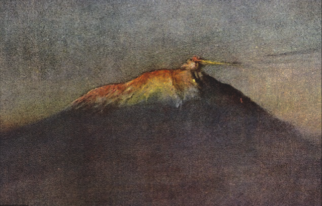
MOUNT EREBUS BY EDWARD ADRIAN WILSON

http://wanderingvertexes.blogspot.com

EDWARD ADRIAN WILSON (1872-1912) 
Mount Erebus (3, 794 m - 12, 448ft)
Antarctica

  In Mount Erebus 1911, watercolour,  Museum- Royal Geographical Society,  London

The mountain 
Mount Erebus (3, 794 m - 12, 448ft), not to be confused with Mount Elbrus is the second-highest volcano in Antarctica (after Mount Sidley) and the southernmost active volcano on Earth. It is the sixth highest ultra mountain on an island, located on Ross Island, which is also home to three inactive volcanoes:  Mount Terror, Mount Bird, and Mount Terra Nova.
The volcano has been active since c. 1.3 million years ago and is the site of the Mount Erebus Volcano Observatory run by the New Mexico Institute of Mining and Technology.
Mount Erebus was discovered on January 27, 1841 (and observed to be in eruption) by polar explorer Sir James Clark Ross who named it and its companion, Mount Terror, after his ships, Erebus and Terror (which were later used by Sir John Franklin on his disastrous Arctic expedition). Erebus is a dark region in Hades in Greek mythology. Present with Ross on the Erebus was the young Joseph Hooker, future president of the Royal Society and close friend of Charles Darwin. Erebus was an Ancient Greek primordial deity of darkness, the son of Chaos.
Mount Erebus is classified as a polygenetic stratovolcano. The bottom half of the volcano is a shield and the top half is a stratocone. The composition of the current eruptive products of Erebus is anorthoclase-porphyritic tephritic phonolite and phonolite, which are the bulk of exposed lava flow on the volcano.  Erebus is the world's only presently erupting phonolite volcano.
Researchers spent more than three months during the 2007–08 field season installing an unusually dense array of seismometers around Mount Erebus to listen to waves of energy generated by small, controlled blasts from explosives they buried along its flanks and perimeter and to record scattered seismic signals generated by lava lake eruptions and local ice quakes. By studying the refracted and scattered seismic waves, the scientists produced an image of the uppermost (top few km) of the volcano to understand the geometry of its "plumbing" and how the magma rises to the lava lake. These results demonstrated a complex upper-volcano conduit system with appreciable upper-volcano magma storage to the northwest of the lava lake at depths hundreds of meters below the surface.

The artist
Edward Adrian Wilson,  nicknamed "Uncle Bill" was an English physician, polar explorer, natural historian, painter and ornithologist. Wilson took part in two British expeditions to Antarctica, the Discovery Expedition (1901-1904)  and the tragic Terra Nova Expedition (1907-1912), both under the leadership of Scott.
Dr. Edward A. Wilson  is widely regarded as one of the finest artists ever to have worked in the Antarctic. Sailing with Captain Scott aboard 'Discovery' (1901-1904), he became the last in a long tradition of 'exploration artists' from an age when pencil and water-colour were the main methods of producing accurate scientific records of new lands and animal species. He combined scientific, topographical and landscape techniques to produce accurate and beautiful images of the last unknown continent. Such was the strength of his work that it also helped to found the tradition of modern wildlife painting. In particular Wilson captured the essence of the flight and motion of Southern Ocean sea-birds on paper.
Returning with Captain Scott aboard 'Terra Nova' (1910-1913) as Chief of Scientific Staff, he continued to record the continent and its wildlife with extraordinary deftness. Chosen to accompany Captain Scott to the South Pole, his last drawings are from one of the most famous epic journeys in exploration history. Along with his scientific work, Wilson's pencil recorded the finding of Roald Amundsen's tent at the South Pole by Captain Scott. Wilson died, along with the other members of the British Pole Party, during the return journey, in March 1912. The drawings and paintings were created at considerable personal cost in the freezing conditions in which Wilson worked. He often suffered severely from the cold whilst sketching and also from snow-blindness, or sunburn of the eye. They provide a remarkable testament to one of the great figures of the heroic age of Antarctic exploration. The book has been produced as a companion volume to 'Edward Wilson's Nature Notebooks' by two of Wilson's great nephews, to mark the centenary of his death.

_______________________________
2018 - Wandering Vertexes..
Un blog de Francis Rousseau

Thursday, October 25, 2018

THE BUET PAINTED BY GABRIEL LOPPÉ


http://wanderingvertexes.blogspot.com

GABRIEL LOPPÉ (1825-1913)
 Mount Buet  (3, 096 m - 10, 157 ft)  
 France 

 In Le Buet vu du glacier d'Argentière, oil on canvas,  John Mitchell Fine Paintings Gallery, London

The mountain 
Mount Buet  (3, 096 m - 10, 157 ft)    also called simply The Buet is a summit of the massif of Giffre, in Haute-Savoie. It is also called the Mont Blanc des Dames (The Ladies Mont Blanc). It dominates the Cirque des Fonds.  From its summit, the highest in the department except  the Mont-Blanc massif, offers an exceptional view of the latter, as well as the red needles and the Haut-Giffre. The Buet played an important role in the birth of mountaineering and the conquest of Mont Blanc in the 18th century.
 The first a ascension took place in 1765 by Genevan scientist Jean André Deluc and his brother. The brothers Deluc reach first the summit of the Buet, on the side of Sixt in 1770. They conduct a series of experiments, including the calculation of the time required to bring water to a boil at this altitude. They are the first to use the barometer to measure an altitude. This epic is considered the first climb in the high mountains in the Alps. Six years later, in 1776, Horace-Bénédict de Saussure took the route and made preliminary observations to the ascent of Mont Blanc.
In 1910, the Grenairon refuge was built on Mount Buet. Destroyed in 1984 by a fire, it was rebuilt in 1985 in the same way.

The painter 
Toussaint Gabriel Loppé was a French painter, photographer and mountaineer. He became the first foreigner to be made a member of the Alpine Club in London. His father was a captain in the French Engineers and Loppé's childhood was spent in many different towns in south-eastern France. Aged twenty-one Loppé climbed a small mountain in the Languedoc and found a group of painters sketching on the summit. He had found his calling and subsequently went off to Geneva where he met the reputed leading Swiss landscapist, Alexandre Calame (1810 -1864). Loppé took up mountaineering in Grindelwald in the 1850s and made friends easily with the many English climbers in France and Switzerland. Although he was frequently labelled as a pupil of Calame and his rival François Diday, Loppé was almost an entirely self-taught artist. He became the first painter to work at higher altitudes during climbing expeditions earning the right to be considered the founder of the peintres-alpinistes school, which became established in the Savoie at the turn of the nineteenth century.
Notable followers of Loppé include, Charles Henri Contencin (1875-1955) and Jacques Fourcy (1906-1990). Together with the first ascent of Mt Mallet in Chamonix’s Grandes Jorasses range, Loppé made over 40 ascents of Mont Blanc during his climbing career, which lasted until the late 1890s.  He frequently made oil sketches from alpine summits, including a panorama of the view from the summit of Mont Blanc.
His paintings became celebrated for their atmosphere and spontaneity and he soon found himself taking part in many exhibitions in London and in Paris.
By 1896 Loppé had spent over fifty seasons climbing and painting in Chamonix. As the valley’s unrivalled ‘Court painter’ his work was in constant demand with the majority of his pictures going to English climbers and summer tourists.
In his later years, Loppé became fascinated with photography and was quite an innovator in this field too. His long exposure photograph of the Eiffel Tower struck by lightning, now in the Musée d'Orsay in Paris remains one of his iconic images. 

_______________________________
2018 - Wandering Vertexes...
by Francis Rousseau