google.com, pub-0288379932320714, DIRECT, f08c47fec0942fa0 GRAVIR LES MONTAGNES... EN PEINTURE: 0 - 1000 meters
Showing posts with label 0 - 1000 meters. Show all posts

Thursday, July 14, 2022

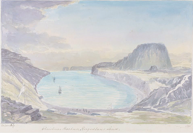
LA TABLE DE L'OISEAU SKETCHED BY CHARLES HAMILTON SMITH

CHARLES HAMILTON SMITH (1776-1859) La Table de l'Oiseau (403m - 1,322 ft) Antarctica - France   In Christmas Harbour,  Kerguelen's Land, watercolor,

CHARLES HAMILTON SMITH (1776-1859)
La Table de l'Oiseau (403m - 1,322 ft)
Antarctica - France

 In Christmas Harbour,  Kerguelen's Land, watercolor


The hill
The Table de l'Oiseau (403m - 1,322 ft) (Table ot the Bird) is a hill overlooking Port-Christmas by the north. Port-Christmas is one of the most isolated and difficult to reach points in the archipelagok.  Given the distance and especially the rugged topography, the site is almost never reached by land. However, it can be reached by sea after sailing for at least 100 nautical miles (190 km). The baie de l'Oiseau, at the bottom of which it is located, forms the first indentation at the northeast end of the Loranchet peninsula. The bay is closed to the north by Cap Français, to the south by Pointe de l'Arche (seen in the foreground).
While the shores of the bay are mostly rocky and often steep, the bottom is occupied by a strike, about 350 meters long, of black sand resulting from the erosion of the surrounding basaltic rocks. pours into the sea, after having collected runoff water from Mount Havergal on the one hand, and that from the outlet of Rochegude Lake on the other. This lake, located about 500 m from the shore and 40 m above sea level, marks the shoulder that separates Port-Christmas from Ducheyron Bay, to the west.
The anchorage at Port-Christmas allows you to anchor at a depth of 11 meters. It offers relatively safe shelter to sailors who frequent this particularly turbulent ocean sector of the Roaring Forties.

The artist
Lieutenant-Colonel Charles Hamilton Smith, was an English artist, naturalist, antiquary, illustrator, soldier, and... spy as well !. His military career began in 1787, when he studied at the Austrian academy for artillery and engineers at Mechelen and Leuven in Belgium (his native country). Although his military service, which ended in 1820 and included the Napoleonic Wars, saw him travel extensively (including the West Indies, Canada, United States, Southern and Northern Europe and ...Antarctica).
As a prolific self-taught illustrator (over 38,000 drawings!) He left quite an important number of books of beautifully watercolored landscapes taken all around the world. those nooks of watercolors are nowadays in the collections of the Yale Center From British Art. Among them :
- Views of France, Volume I (81 watercolors), Views of France, Volume II (93 watercolors),
- Views of England and Wales, Volume I (82 watercolors), Views of England and Wales, Volume II (74 watercolors),
- Views of Northern Europe, Volume I (68 watercolors), Views of Northern Europe, Volume II (78) watercolors),
- Views of Polar Regions (75 watercolors) (see above)
- Views of Spain, Volume I (69 watercolors), Views of Spain, Volume II (72 watercolors), But one of his noteworthy achievements was an 1800 experiment to determine which color should be used for military uniforms. He is also known in military history circles for Costume of the Army of the British Empire, produced towards the end of the Napoleonic Wars and an accurate depiction of contemporary British uniform.
As an antiquarian, he also produced, in collaboration with Samuel Rush Meyrick, Costume of the Original Inhabitants of the British Islands, 1815, and The Ancient Costume of England, with historical illustrations of medieval knights, ladies, shipsm and battles.
He also wrote on the history of the Seven Years' War and The Natural history of dogs.
Quite a productive fellow !
___________________________________________

2022 - Wandering Vertexes...
by Francis Rousseau
Saturday, July 2, 2022

VERY LARGE ICEBERG PAINTED BY ROCKWELL KENT

ROCKWELL KENT (1882-1971), Very Large Iceberg (180m-590ft) Greenland / Danemark  In "Grayday, Green land Iceberg", oil on canvas.


ROCKWELL KENT (1882-1971)
Very Large Iceberg (180m-590ft) Greenland / Danemark
In "Grayday, Green land Iceberg", oil on canvas.


The painter
Rockwell Kent, artist, author, and political activist, had a long and varied career. During his lifetime, he worked as an architectural draftsman, illustrator, printmaker, painter, lobsterman, ship's carpenter, and dairy farmer. Born in Tarrytown Heights, New York, he lived in Maine, Newfoundland, Alaska, Greenland, and the Adirondacks and explored the waters around Tierra del Fuego in a small boat. Kent's paintings, lithographs, and woodcuts often portrayed the bleak and rugged aspects of nature; a reflection of his life in harsh climates.His experience as a carpenter and builder and his familiarity with tools served him well when he took up the graphic process. His blocks were marvels of beautiful cutting, every line deliberate and under perfect control. The tones and lines in his lithography were solidly built up, subtle, and full of color. He usually made preliminary studies- old-mater style- for composition or detail before starting on a print. Nothing was vague or accidental about his work; his expression was clear and deliberate. Neither misty tonalities nor suggestiveness were to his taste. He was a highly objectified art - clean, athletic, sometimes almost austere and cold. He either recorded adventures concretely, or dealt in ideas. His studio was a model of the efficient workshop: neat, orderly, with everything in its place. His handwriting, the fruit of his architectural training, was beautiful and precise.
Among the many notes of increasing awareness of Kent's contributions to American culture is the reproduction of one of Kent's pen-and-ink drawings from Moby Dick on a U.S. postage stamp, part of the 2001 commemorative panel celebrating such American illustrators as Maxfield Parrish, Frederic Remington, and Norman Rockwell.

The Iceberg
An iceberg is a piece of freshwater ice more than 15 m long that has broken off a glacier or an ice shelf and is floating freely in open (salt) water.  Smaller chunks of floating glacially-derived ice are called "growlers" or "bergy bits".  Both are generally spawned from disintegrating icebergs.[ Iceberg size classes, as established by the International Ice Patrol, are summarized in Table 1. The 1912 loss of the RMS Titanic led to the formation of the International Ice Patrol in 1914. Much of an iceberg is below the surface, which led to the expression "tip of the iceberg" to illustrate a small part of a larger unseen issue. Icebergs are considered a serious maritime hazard.  Icebergs vary considerably in size and shape. Icebergs that calve from glaciers in Greenland, are often irregularly shaped while Antarctic ice shelves often produce large tabular (table top) icebergs. The largest iceberg currently floating in the ocean, named A-76, calved from the Ronne Ice Shelf into the Weddell Sea in Antarctica measuring 4320 km2.  The largest iceberg in recent history, named B-15, measured nearly 300 km x 40 km. The B-15 iceberg calved from the Ross Ice Shelf in January 2000.  The largest iceberg on record was an Antarctic tabular iceberg of over 31,000 square kilometres (12,000 sq mi) [335 by 97 kilometres (208 by 60 mi)] sighted 240 kilometres (150 mi) west of Scott Island, in the South Pacific Ocean, by the USS Glacier on November 12, 1956. This iceberg was larger than Belgium. Big icebergs are also often compared in size to the area of Manhattan The largest icebergs recorded have been calved, or broken off, from the Ross Ice Shelf of Antarctica. Icebergs may reach a height of more than 100 metres (300 ft) above the sea surface, and have mass ranging from about 100,000 tonnes up to more than 10 million tonnes. Icebergs or pieces of floating ice smaller than 5 meters above the sea surface are classified as "bergy bits"; smaller than 1 meter—"growlers". The largest known iceberg in the North Atlantic was 168 metres (551 ft) above sea level, reported by the USCG icebreaker Eastwind in 1958, making it the height of a 55-story building. These icebergs originate from the glaciers of western Greenland and may have interior temperatures of −15 to −20 °C (5 to −4 °F).


___________________________________________
2022 - Wandering Vertexes...
by Francis Rousseau

Sunday, June 12, 2022

THE BASTEI CLIFF PAINTED BY CASPAR DAVID FRIEDRICH


CASPAR DAVID FRIEDRICH (1774-1840) The Bastei Cliff (194 m - 636 ft) Germany  / Czech Republic border,  In "Felsenschlucht", oil on canvas , 1822

CASPAR DAVID FRIEDRICH (1774-1840)
The Bastei Cliff (194 m - 636 ft)
Germany  / Czech Republic border

 In "Felsenschlucht", oil on canvas , 1822


The rock
The Bastei (194 m - 636 ft) is a rock formation rising 194 metres above the Elbe River in the Elbe Sandstone Mountains  (723 m - 2,372 ft) of Germany. Reaching a height of 305 metres above sea level, the jagged rocks of the Bastei were formed by water erosion over one million years ago. They are situated near Rathen, not far from Pirna southeast of the city of Dresden, and are the major landmark of the Saxon Switzerland National Park. They are also part of a climbing and hiking area that extends over the borders into the Bohemian Switzerland (Czech Republic). The Bastei has been a tourist attraction for over 200 years. In 1824, a wooden bridge was constructed to link several rocks for the visitors. This bridge was replaced in 1851 by the present Bastei Bridge made of sandstone. The rock formations and vistas have inspired numerous artists, among them Caspar David Friedrich in "Felsenschlucht" (above)
The spa town of Rathen is the main base for visiting the Bastei; the town can be reached from Dresden by paddle steamer on the river Elbe.
The Bastei is one of the most prominent lookout points in Saxon Switzerland. In 1819 August von Goethe extolled the views: "Here, from where you see right down to the Elbe from the most rugged rocks, where a short distance away the crags of the Lilienstein, Königstein and Pffafenstein stand scenically together and the eye takes in a sweeping view that can never be described in words." Today the Bastei still has the highest number of visitors of all the lookout points in Saxon Switzerland. In addition to the actual vista, there are also other points of interest. At the Jahrhundertturm, a rock pinnacle on the Bastei Bridge, there are tablets commemorating the first mention of the Bastei in travel literature (in 1797) as well as the memory of Wilhelm Lebrecht Götzinger and Carl Heinrich Nicolai. These last two were amongst the pioneers of tourism in Saxon Switzerland, thanks to their descriptions of their journeys and their other works. Another tablet commemorates the Saxon court photographer, Hermann Krone, who took the first landscape photographs in Germany at the Bastei Bridge in 1853. From the Ferdinandstein, part of the Wehltürme rock towers, there is a famous view of the Bastei Bridge. It is reached over a branch from the route to the bridge. Another well-known rock formation in the vicinity of the Bastei is the Wartturm, a large piece of which broke off in 2000. Neurathen Castle, the largest rock castle in Saxon Switzerland, may be reached from the Bastei by crossing the Bastei Bridge. The ruins of the castle, some timber rebates, rooms carved out of the rock, a cistern and stone shot from a medieval catapult or slingshot may be viewed on a self-conducted circular walk. A replica slingshot was put on display in the castle in 1986. The finds from excavations in the area, especially pottery, can also be seen. The climb from Rathen to the Bastei runs past an open-air museum dedicated to Slavic settlement in the region and also past the path leading to the Rathen Open Air Stage. Another famous landmark in the local area is the fortress of Königstein.


The painter
Caspar David Friedrich was a 19th-century German Romantic landscape painter, considered as the most important German artist of his generation. He is best known for his mid-period allegorical landscapes which typically feature contemplative figures silhouetted against night skies, morning mists, barren trees or Gothic ruins. His primary interest as an artist was the contemplation of nature, and his often symbolic and anti-classical work seeks to convey a subjective, emotional response to the natural world. Friedrich's paintings characteristically set a human presence in diminished perspective amid expansive landscapes, reducing the figures to a scale that, according to the art historian Christopher John Murray, directs "the viewer's gaze towards their metaphysical dimension".
Friedrich was born in Pomerania, where he began to study art. He studied in Copenhagen until 1798, before settling in Dresden. A disillusionment with materialistic society was giving rise everywhere in Europe. This shift in ideals was often expressed through a reevaluation of the natural world, as artists such as J. M. W. Turner (1775–1851) and John Constable (1776–1837) sought to depict nature as a "divine creation, to be set against the artifice of human civilization"....


_____________________________________
2022 - Wandering Vertexes...
Un blog de Francis Rousseau


Tuesday, May 31, 2022

ULURU / AYERS ROCKS PHOTOGRAPHED IN 1894 BY WALTER BALDWIN SPENCER


WALTER BALDWIN SPENCER (1860-1929) Uluru /Ayers Rock (863 m -2,831 ft) Australia (Northern Territory)   In  Uluru, Ayers Rock, central Australia, 1894,  Glass plate negative 80 mm x 106 mm, Museums Victoria

WALTER BALDWIN SPENCER (1860-1929)
Uluru /Ayers Rock (863 m -2,831 ft)
Australia (Northern Territory)


In Uluru, Ayers Rock, central Australia, 1894, Glass plate negative 80 mm x 106 mm, 
Museums Victoria


The artist
Sir Walter Baldwin Spencer commonly referred to as Baldwin Spencer, was a British-Australian evolutionary biologist, anthropologist and ethnologist. He is known for his fieldwork with Aboriginal peoples in Central Australia, contributions to the study of ethnography, and academic collaborations with Frank Gillen. Spencer introduced the study of zoology at the University of Melbourne and held the title of Emeritus Professor until his death in 1929.In 1894 a new field was opened up for Spencer when he joined the W.A. Horn scientific expedition which left Adelaide in May 1894 to explore Australia. Spencer paid two more visits to the centre of Australia, one in 1923 with Dr Leonard Keith Ward, the government geologist of South Australia, and the other in 1926. These visits enabled Spencer to revise his earlier researches and consider on the spot various opposing theories that had been brought forward. His The Arunta: a Study of a Stone Age People (1927), revisits and reaffirms his earlier conclusions; Gillen's name as joint author appeared on the title-page though he had died 15 years before. Wanderings in Wild Australia, published a year later and slightly more popular in form, completes the list of his books. A list of his other published writings will be found in Spencer's Last Journey (1931). Spencer went to London in 1927 to see these books through the press. Ten years before he had said that he realised he was not getting younger and must regard his field work as finished. In February 1929, however, in his sixty-ninth year, he travelled in a cargo boat to Magallanes and then went in a little schooner to Ushuaia at the south of Tierra del Fuego. 


The mountain 
Uluru (863m -2,831 ft) also known as Ayers Rock (in honour of the then Chief Secretary of South AustraliaSir Henry Ayers) is a large sandstone rock formation in the southern part of the Northern Territory in central Australia.   Officially  the rock is gazetted as "Uluru / Ayers Rock". 
It lies 335 km (208 mi) south west of the nearest large town, Alice Springs, 450 km (280 mi) by road.
Kata Tjuta and Uluru are the two major features of the Uluṟu-Kata Tjuṯa National Park. Uluru is sacred to the Pitjantjatjara Anangu, the Aboriginal people of the area. The area around the formation is home to an abundance of springs, waterholes, rock caves, and ancient paintings.  Both Uluru and the nearby Kata Tjuta formation have great cultural significance for the Aṉangu people, the traditional inhabitants of the area, who lead walking tours to inform visitors about the local flora and fauna, bush food and the Aboriginal dreamtime stories of the area.
Uluru is notable for appearing to change colour at different times of the day and year, most notably when it glows red at dawn and sunset.
Uluru is listed as a UNESCO World Heritage Site.
Uluru is an inselberg, literally "island mountain"An inselberg is a prominent isolated residual knob or hill that rises abruptly from and is surrounded by extensive and relatively flat erosion lowlands in a hot, dry region.  Uluru is also often referred to as a monolith, although this is a somewhat ambiguous term that is generally avoided by geologists. The remarkable feature of Uluru is its homogeneity and lack of jointing and parting at bedding surfaces, leading to the lack of development of scree slopes and soil. These characteristics led to its survival, while the surrounding rocks were eroded. For the purpose of mapping and describing the geological history of the area, geologists refer to the rock strata making up Uluru as the Mutitjulu Arkose, and it is one of many sedimentary formations filling the Amadeus Basin.
According to the Aṉangu, traditional landowners of Uluru: 
The world was once a featureless place. None of the places we know existed until creator beings, in the forms of people, plants and animals, traveled widely across the land. Then, in a process of creation and destruction, they formed the landscape as we know it today. Aṉangu land is still inhabited by the spirits of dozens of these ancestral creator beings which are referred to as Tjukuritja or Waparitja.
There are a number of differing accounts given, by outsiders, of Aboriginal ancestral stories for the origins of Uluru and its many cracks and fissures. One such account, taken from Robert Layton's (1989) Uluru: An Aboriginal history of Ayers Rock, reads as follows:
Uluru was built up during the creation period by two boys who played in the mud after rain. When they had finished their game they travelled south to Wiputa ... Fighting together, the two boys made their way to the table topped Mount Conner, on top of which their bodies are preserved as boulders. 
Two other accounts are given in Norbert Brockman's (1997) Encyclopedia of Sacred Places.
The first tells of serpent beings who waged many wars around Uluru, scarring the rock. The second tells of two tribes of ancestral spirits who were invited to a feast, but were distracted by the beautiful Sleepy Lizard Women and did not show up. In response, the angry hosts sang evil into a mud sculpture that came to life as the dingo. There followed a great battle, which ended in the deaths of the leaders of both tribes. The earth itself rose up in grief at the bloodshed, becoming Uluru.
The Commonwealth Department of Environment's webpage advises:
Many...Tjukurpa such as Kalaya (Emu), Liru (poisonous snake), Lungkata (blue tongue lizard), Luunpa (kingfisher) and Tjintir-tjintirpa (willie wagtail) travel through Uluṟu-Kata Tjuṯa National Park. Other Tjukurpa affect only one specific area.
Kuniya, the woma python, lived in the rocks at Uluru where she fought the Liru, the poisonous snake.
It is sometimes reported that those who take rocks from the formation will be cursed and suffer misfortune. There have been many instances where people who removed such rocks attempted to mail them back to various agencies in an attempt to remove the perceived curse.

__________________________________________
2022 - Wandering Vertexes...
by Francis Rousseau

Wednesday, April 20, 2022

LE ROCHER DES DEUX TROUS PAINTED BY VINCENT VAN GOGH


VINCENT VAN GOGH (1853-1890) Le Rocher des Deux Trous (348m - France (Provence)


VINCENT VAN GOGH (1853-1890)
Le Rocher des Deux Trous (348m - 1,141 ft)
France (Provence)


The hill
The Rocher des Deux Trous (348m) in the Alpilles massif is one of the most popular hikes for walkers, satrting from Saint-Remy de Provence. It offers a 360° panorama over the two slopes of the Alpilles and over the entire surrounding region, from Mont Ventoux to the north and as far as the Mediterranean Sea to the south, on a clear day. This picturesque rock eroded and sculpted by the North wind (the Mistral) was painted by Van Gogh during his stay in Saint-Paul de Mausole from May 1889 to May 1890.

The painter
Vincent Willem van Gogh was a Dutch Post-Impressionist painter who is among the most famous and influential figures in the history of Western art. In just over a decade he created about 2100 artworks, including around 860 oil paintings, most of them in the last two years of his life. They include landscapes, still lifes, portraits and self-portraits, and are characterized by bold, symbolic colours, and dramatic, impulsive and expressive brushwork that contributed to the foundations of modern art. He died by suicide at 37, following years of mental illness and poverty.
Born into an upper-middle-class family, Van Gogh drew as a child and was serious, quiet and thoughtful. As a young man he worked as an art dealer, often travelling, but became depressed after he was transferred to London. He turned to religion, and spent time as a missionary in southern Belgium. Later he drifted in ill health and solitude. He took up painting in 1881 having moved back home with his parents. His younger brother Theo supported him financially, and the two kept up a long correspondence by letter.
More about Vincent Van Gogh

_______________________________

2022 - Wandering Vertexes...
by Francis Rousseau

Sunday, April 3, 2022

THE CAP D'ANTIBES PAINTED BY NICOLAS DE STAËL


NICOLAS DE STAËL (1914-1955) Cap d'Antibes (19 m - 62,3 ft) France (Var)  In  Marine au cap d'Antibes, 1954 oil on canvas, 88.3 x 129.5 cm, Private collection.

NICOLAS DE STAËL (1914-1955)
Cap d'Antibes (19 m - 62,3 ft)
France (Alpes Maritimes)

In  Marine au cap d'Antibes, 1954 oil on canvas, 88.3 x 129.5 cm, Private collection.


The Cap
Cap d'Antibes commonly refers to a peninsula located south of Antibes and east of Juan-les-Pins, on the Côte d'Azur in France. Geographical Cap d'Antibes is located to the south of this peninsula, near Argent Faux Cove and Villa Eilenroc, on the coastal path at the start of Golfe Juan. The history of Cap d'Antibes is linked to that of Antibes, whose exceptional site has been known since ancient times.
The coastal path known as “Tire-Poil” allows walkers to explore the cape in good weather, from the Garoupe beach car park to Villa Eilenroc. Walking as close as possible to the waves, this 2.7 km route makes its way through the steep rocks and along the imposing walls of the Garoupe and Croë castles. It offers an exceptional panorama, to the west on the Lérins islands, and to the east on the first summits of Mercantour. Built at the highest point of the cape and next to the ancient chapel of Notre Dame de Bon Port, the Garoupe lighthouse dominates the Gulf of Juan and the Bay of Angels. L'Abri de l'Olivette, a port-shelter where typical boats of the region anchor, is located on its west coast.The site benefits from the visit of personalities from the world of cinema, mainly during the Cannes Film Festival, which increases the notoriety of the place.  It was around the middle of the 19th century that the Cap d'Antibes really began to develop.  At that time, wealthy tourists from all over Europe, especially England and Russia, discovered the place and built luxurious homes there.  It was the Comte de Fersen, colonel and aide-de-camp to the Tsar, who opened up Cap d'Antibes in 1863 by tracing a road around the peninsula. Thus, the knight James Close, former banker of François II (king of the Two Sicilies), settled in 1864 in Antibes and bought 17,000 m2 of land there in Cap before dying in 1865. In 1880, the current location of Juan-les-Pins was discovered by the Duke of Albany, son of Queen Victoria. At that time, Juan-les-Pins was just a pine forest, bordered by idyllic sandy beaches. Juan-les-Pins was also called Albany-les-Bains until 1884. In 1893, Georges Gallice acquired land located at the start of the Cap road and a small port attached to his property would later become Port Gallice.

The painter
Nicolas de Staël was a French painter of Russian origin known for his use of a thick impasto and his highly abstract landscape painting. Nicolas de Staël was born Nikolai Vladimirovich Stael von Holstein (Николай Владимирович Шталь фон Гольштейн) in Saint Petersbourg (Russia), into the family of a Baron Vladimir Stael von Holstein, the last Commandant of the Peter and Paul Fortress. De Staël's family was forced to emigrate to Poland in 1919 because of the Russian Revolution ; both his father and stepmother died in Poland and the orphaned Nicolas de Staël was sent with his older sister Marina to Brussels to live with a Russian family (1922)...
- More about Nicolas de Stael biography
___________________________________________

2022 - Wandering Vertexes...
by Francis Rousseau


Saturday, January 29, 2022

LES DENTELLES DE MONTMIRAIL(2) SKETCHED BY A. G. CARRICK / H.M KING CHARLES III

A. G. CARRICK / H.M KING CHARLES III former PRINCE OF WALES (bn.1948)Les dentelle de Mont-Mirail- Crête de Saint Amand (722 m - 23,68ft) France (Vaucluse)  In View of Les Dentelles de Montmirail,  watercolor, 1993, Private collection


A. G. CARRICK / H.M KING CHARLES III former PRINCE OF WALES (bn.1948)
Les Dentelles de Montmirail  (722 m - 23,68ft)
France (Vaucluse)

In View of Les Dentelles de Montmirail,  watercolor, 1993, Private collection


The mountains
The Dentelles de Montmirail (722 m - 23,68ft) are a small chain of mountains in Provence in France, in the département of Vaucluse, located just to the south of the village of Vaison-la-Romaine. They are foothills of the highest peak in Provence, Mont Ventoux, which is situated just to the east. The dramatically jagged shape of their peaks was formed by horizontal strata of Jurassic limestone being folded and forced into a nearly upright position and subsequently eroded into sharp-edged ridges and spikes. The highest peak of the Dentelles is St-Amand, at 734 m (2,400 ft). The range, which is about 8 km wide, offers over 600 trails for walking, rock climbing, and mountain biking.]The foot of the Dentelles is surrounded by vineyards of the Rhône Valley. Their name Dentelles, the French word for "lace," refers to their shape obtained by erosion, while Montmirail is derived from the Latin mons mirabilis meaning 'admirable mountain'.
Located on the territory of the communes of Beaumes-de-Venise, Crestet, Gigondas, La Roque-Alric, Lafare, Le Barroux, Malaucène, Suzette, and Vacqueyras; the Dentelles de Montmirail were an important natural frontier during Antiquity between the tribes of the Memini in the south, and the Voconces in the north.

The painter
Arthur George Carrick is actually H.M. the King Charles III, former Prince of Wales.
When he began showing his paintings, he was too nervous to display his name so displayed under a pseudonym. Arthur George are two of his names (Charles Phillip Arthur George) and one of his titles is Earl of Carrick. King Charles III is an experienced watercolourist.  He has been painting for most of his adult life, during holidays or when his official diary allows. King Charles' interest began during the 1970s and 1980s when he was inspired by Robert Waddell, who had been his art master at Gordonstoun in Scotland. In time, King Charles met leading artists such as Edward Seago, with whom he discussed watercolour technique, and received further tuition from John Ward, Bryan Organ and Derek Hill.
The Royal Family has a tradition of drawing and painting, and King Charles’ work first came to public notice at a 1977 exhibition at Windsor Castle at which other Royal artists included Queen Victoria, The Duke of Edinburgh and The Duke of York.
King Charles paints in the open air, often finishing a picture in one go and his favourite locations include The Queen's estate at Balmoral in Scotland and Sandringham House in Norfolk, England. Sometimes King Charles  III paints during his skiing holidays, and during overseas tours when possible.
The copyright of King Charles' watercolours belongs to A. G. Carrick Ltd, a trading arm of The King's Charities Foundation. Over the years King Charles III has agreed to exhibitions of his watercolours and of lithographs made from them, on the understanding that any income they generate goes to The Prince of Wales's Charitable Foundation.
Money from the sale of the lithographs also goes to the Foundation but the paintings themselves are never for sale.
In the 1980s King Charles III, then Prince of Wales,  began inviting young British artists to accompany him on official tours overseas and record their impressions, a tradition that has continued to this day.
Reference :
- The prince of Wales paintings 
___________________________________________

2022 - Wandering Vertexes...
by Francis Rousseau

Thursday, January 6, 2022

MILESOVKA PAINTED BY CASPAR DAVID FRIEDRICH

CASPAR DAVID FRIEDRICH (1774-1840) Milešovka (837m - 2, 746ft) Czech Republic  In Mountain Landscape with Rainbow ca.1809-1810, Museum Folkwang, Essen, Germany


CASPAR DAVID FRIEDRICH (1774-1840)
Milešovka (837m - 2, 746ft)
Czech Republic

In Mountain Landscape with Rainbow ca.1809-1810, Museum Folkwang, Essen, Germany

 
The mountain
Milešovka (837m - 2, 746 ft), an isolated phonolite cone, is the highest mountain of České Středohoří (Czech Central Mountains Range), a picturesque mountain range in northwest Bohemia, in Czech Republic. Situated right in the middle of the European Continent, it has a volcanic origin. The range covers an area of more than 1000 km2 with many hills typically volcano shaped. Their unique appearance were attracting numbers of naturalists, painters, poets and nature-lovers.
Mount Milešovka is located over the village of Milesov about 10km northwestward of Lovosice. The peak is ranked among the most windy mountains in Czech Republic. The very first chalet had been built up in 1825, other buildings soon followed as well as the outlook tower in 1850. The famous traveler Alexander von Humboldt is responsible for their construction, he labeled the view from Milesovka as "the third most beautiful in the world", making it really worth visiting. From there, one can see the scenery view of Ceske Stredohori, the Polabska nizina lowlands and the ridge of the Krusne hory mountains. Milesovka adjoins with a peak called Paskapole which is crossed by the road connecting Prague with Teplice.


The painter
Caspar David Friedrich was a 19th-century German Romantic landscape painter, considered as the most important German artist of his generation. He is best known for his mid-period allegorical landscapes which typically feature contemplative figures silhouetted against night skies, morning mists, barren trees or Gothic ruins. His primary interest as an artist was the contemplation of nature, and his often symbolic and anti-classical work seeks to convey a subjective, emotional response to the natural world. Friedrich's paintings characteristically set a human presence in diminished perspective amid expansive landscapes, reducing the figures to a scale that, according to the art historian Christopher John Murray, directs "the viewer's gaze towards their metaphysical dimension".
Friedrich was born in Pomerania, where he began to study art. He studied in Copenhagen until 1798, before settling in Dresden. A disillusionment with materialistic society was giving rise everywhere in Europe. This shift in ideals was often expressed through a reevaluation of the natural world, as artists such as J. M. W. Turner (1775–1851) and John Constable (1776–1837) sought to depict nature as a "divine creation, to be set against the artifice of human civilization"....
- More informations about Caspar David Friedrich life and work 

 _____________________________________
2022 - Wandering Vertexes...
Un blog de Francis Rousseau

Monday, January 3, 2022

FALAISE DES VACHES NOIRES PAINTED BY GUSTAVE CAILLEBOTTE


GUSTAVE CAILLEBOTTE (1848-1894) Falaise des Vaches Noires (110 m- 360 ft) France (Normandie)   In Cliffs at Villers sur mer 1880, 65 x 81 cm, Private collection

GUSTAVE CAILLEBOTTE (1848-1894)
Falaise des Vaches Noires (110 m- 360 ft)
France (Normandie)

 In Cliffs at Villers sur mer 1880, 65 x 81 cm, Private collection


The cliffs
The Vaches Noires cliffs (Black Cows Cliffs)  (110 m- 360 ft)  is a remarkable natural site located in the municipalities of Houlgate, Gonneville-sur-Mer, Auberville, Villers-sur-Mer, in Calvados, in Normandy (France). The toponym "Black Cows" designates blocks of chalk having rolled from the top of the cliff on the foreshore, the black color of which is due to the kelp having attached itself to it.The Vaches Noires cliffs are made up of clay cliffs capped at their summit (altitude 110 m) with a thin chalk cliff.

This area is geologically remarkable. The Oxfordian marls, under the action of the water runoff from the aquifer which surmounts them, are notched by deep ravines. These are traversed by mud flows which advance slowly towards the sea and contain blocks of Cretaceous chalk coming from the summit. At high tide, the waves attack the front of the lava flows, releasing extremely varied fossils. The cliffs are made up of a succession of layers of clay, marl and chalk. Due to the risk of landslide and the fragility of the clay cliffs, the cliffs are now protected, their access has been prohibited by decree of classification as a "site of scientific and landscaped interest in the Calvados department" of 20 February 1995 from theFrench Ministry of the Environment.


The painter
The very important french painter Gustave Caillebotte, (known in US more than his own country) was a member and patron of the artists known as Impressionists,(or independents) although he painted in a more realistic manner than many others in the group. Caillebotte was noted for his early interest in photography as an art form.
With regard to the composition and painting style of his works, Caillebotte may be considered part of the first movement after Impressionism: Neo-Impressionism. The second period of Pointillism, whose main representative was Georges Seurat, announced its influence in the late works that Caillebotte painted at his country house in Petit Gennevilliers.
Caillebotte's style belongs to the School of Realism but was strongly influenced by his Impressionist associates. In common with his precursors Jean-François Millet and Gustave Courbet, as well his contemporary Degas, Caillebotte aimed to paint reality as it existed and as he saw it, hoping to reduce the inherent theatricality of painting. Perhaps because of his close relationship with so many of his peers, his style and technique vary considerably among his works, as if "borrowing" and experimenting, but not really sticking to any one style. At times, he seems very much in the Edgar Degas camp of rich-colored realism (especially his interior scenes); at other times, he shares the Impressionist commitment to "optical truth" and employs an impressionistic pastel-softness and loose brush strokes most similar to Renoir and Pissarro, although with a less vibrant palette.
The tilted ground common to these paintings is very characteristic of Caillebotte's work, which may have been strongly influenced by Japanese prints and the new technology of photography, although evidence of his use of photography is lacking. Cropping and "zooming-in", techniques that commonly are found in Caillebotte's oeuvre, may also be the result of his interest in photography, but may just as likely be derived from his intense interest in perspective effects. A large number of Caillebotte's works also employ a very high vantage point, including View of Rooftops - Snow (Vue de toits (Effet de neige) 1878, Boulevard Seen from Above (Boulevard vu d'en haut) 1880, and A Traffic Island (Un refuge, boulevard Haussmann), 1880.
Caillebotte is best known for his paintings of still life, water sports and urban Paris, The latter is almost unique among his works for its particularly flat colors and photo-realistic effect, which give the painting its distinctive and modern look, almost akin to American Realists such as Edward Hopper.

___________________________________________
2022 - Wandering Vertexes...
by Francis Rousseau

Wednesday, December 22, 2021

LA PORTE D'AMONT / ETRETAT CLIFFS PAINTED BY CLAUDE MONET

CLAUDE MONET (1840-1926) La Porte d'Amont - The Falaises d'Etretat (70 to 90 m - 230 to 300 ft France (Normandie)  In La Porte d'Amont, Etreta, 1868, Oil on canvas 81.3 x 100.3 cm.  ogg Art Museum / Harvard University, Cambridge MA

CLAUDE MONET (1840-1926)
La Porte d'Amont - The Falaises d'Etretat (70 to 90 m - 230 to 300 ft
France (Normandie)

In La Porte d'Amont, Etretat, 1868, Oil on canvas 81.3 x 100.3 cm. 
Fogg Art Museum / Harvard University, Cambridge, MA
 
 
The cliffs 
Etretat is best known for its chalk cliffs, including three natural arches and a pointed formation called L'Aiguille (the Needle), which rises 70 m- 230 ft above the sea. The Etretat Chalk Complex, as it is known, consists of a complex stratigraphy of Turonian and Coniacian chalks. Some of the cliffs are as high as 90 metres (300 ft).
These cliffs and the associated resort beach attracted artists including Eugène Boudin, Gustave Courbet and Claude Monet.  They were featured prominently in the 1909 Arsène Lupin novel The Hollow Needle by Maurice Leblanc. They also feature in the 2014 film Lucy, directed by Luc Besson.
Two of the three famous arches are visible from the town, the Porte d'Aval (Aval Cliff)  and the Porte d'Amont (Amont Cliff).  The Manneporte  (Main Door) is the third and the biggest one, and cannot be seen from the town.
La porte d'Amont (Amont Cliff) is the smallest of the three doors and the most visually famous.  The french writer Guy de Maupassant compares this cliff of upstream to " an elephant that plunges its trunk into the water ". At the top of the cliff stands the stone silhouette of the chapel Notre-Dame-de-la-Garde, protector of fishermen. The present building succeeds a chapel of the nineteenth century. You can also reach the cliff but the staircase is much steeper.  The current building succeeds a 19th century chapel in neo-gothic style.   It was destroyed by the occupier during the Second World War. Then one arrive at the monument and the museum made by the architect Gaston Delaune and dedicated to Charles Nungesser and François Coli, two aviators who tried to rally New York in 1927 and which were seen for the last time in this place, after Having taken off from Le Bourget on the edge of their plane, the mythical White Bird.

The painter
The painter Oscar-Claude Monet better known as Claude Monet was a founder of French Impressionist painting, and the most consistent and prolific practitioner of the movement's philosophy of expressing one's perceptions before nature, especially as applied to plein-air landscape painting. The term "Impressionism" is derived from the title of his painting « Impression, soleil levant » (Impression, Sunrise), which was exhibited in 1874 in the first of the independent exhibitions mounted by Monet and his associates as an alternative to the Salon de Paris.
Monet's ambition of documenting the French countryside led him to adopt a method of painting the same scene many times in order to capture the changing of light and the passing of the seasons exactly like the japanese artist Hokusai (1760-1849) did with his 36 views of Mount Fuji.
Monet repeated this kinf of "exercise de stylee with his series on Les Petites Dalles. and Kolsass mountain.
Monet has been described as "the driving force behind Impressionism". Crucial to the art of the Impressionist painters was the understanding of the effects of light on the local colour of objects, and the effects of the juxtaposition of colours with each other. Monet's long career as a painter was spent in the pursuit of this aim.
In 1856, his chance meeting with Eugene Boudin, a painter of small beach scenes, opened his eyes to the possibility of plein-air painting. From that time, with a short interruption for military service, he dedicated himself to searching for new and improved methods of painterly expression. To this end, as a young man, he visited the Paris Salon and familiarised himself with the works of older painters, and made friends with other young artists. The five years that he spent at Argenteuil, spending much time on the River Seine in a little floating studio, were formative in his study of the effects of light and reflections. He began to think in terms of colours and shapes rather than scenes and objects. He used bright colours in dabs and dashes and squiggles of paint. Having rejected the academic teachings of Gleyre's studio, he freed himself from theory, saying "I like to paint as a bird sings."
In 1877 a series of paintings at Gare St-Lazare had Monet looking at smoke and steam and the way that they affected colour and visibility, being sometimes opaque and sometimes translucent. He was to further use this study in the painting of the effects of mist and rain on the landscape. The study of the effects of atmosphere were to evolve into a number of series of paintings in which Monet repeatedly painted the same subject in different lights, at different hours of the day, and through the changes of weather and season. This process began in the 1880s and continued until the end of his life in 1926.
His first series exhibited as such was of Haystacks, painted from different points of view and at different times of the day. Fifteen of the paintings were exhibited at the Galerie Durand-Ruel in 1891. In 1892 he produced what is probably his best-known series, Twenty-six views of Rouen Cathedral. In these paintings Monet broke with painterly traditions by cropping the subject so that only a portion of the facade is seen on the canvas. The paintings do not focus on the grand Medieval building, but on the play of light and shade across its surface, transforming the solid masonry.
Other series include Peupliers, Matins sur la Seine, and the Nenuphars that were painted on his property at Giverny. Between 1883 and 1908, Monet traveled to the Mediterranean, where he painted landmarks, landscapes, and seascapes, including a series of paintings in Antibes (above) and Venice. In London he painted four series: the Houses of Parliament, London ; Charing Cross Bridge ; Waterloo Bridge, and Views of Westminster Bridge. Helen Gardner writes: "Monet, with a scientific precision, has given us an unparalleled and unexcelled record of the passing of time as seen in the movement of light over identical forms."
___________________________________________

2021 - Wandering Vertexes...
by Francis Rousseau

Tuesday, December 7, 2021

DJEBEL BOUKORNINE (2) PAINTED BY ALBERT MARQUET


ALBERT MARQUET (1875–1947) Jebel Boukornine (546 m -1791 ft) Tunisia  In Sidi Bou Saïd-palmier, oil on canvas, private collection

ALBERT MARQUET (1875–1947)
DJebel Boukornine (546 m -1791 ft)
Tunisia

In Sidi Bou Saïd-palmier, oil on canvas, private collection


The mountain
DJebel Boukornine (جبل بوقرنين‎), also spelled Jebel Bou Kornine or Mount Bou Kornine, is a 576-meter mountain in northern Tunisia, overlooking the Gulf of Tunis and Hammam Lif city.
It consists of folded and faulted outcrops of Jurassic limestone. Its name "bou kornine" comes from Tunisian Arabic meaning "the one with two horns", originally from the punic language as "ba'al kornine", meaning "lord with two horns". It owes its name to the two highlights of altitude 576 and 493 meters at the top. During the times of ancient Carthage, the mountain was considered sacred and religious rituals were conducted there.
The massif is part of Boukornine National Park, covering area of 1939 ha and protecting many species of plants and animals. The mountain slopes are covered Aleppo pine and cedar. Djebel Ressas about 30 km to the southwest is a taller peak at 795 m.

The painter
Albert Marquet  was a French painter, associated with the Fauvist movement. He initially became one of the Fauve painters and a lifelong friend of Henri Matisse. In 1890 Marquet moved to Paris to attend the Ecole des Arts Décoratifs, where he met Henri Matisse. They were roommates for a time, and they influenced each other's work. Marquet began studies in 1892 at the École des Beaux-Arts de Paris under Gustave Moreau, the famous symbolist artist. In 1905 he exhibited at the Salon d'Automne. Dismayed by the intense coloration in these paintings, critics reacted by naming the artists the "Fauves", i.e. the wild beasts. Although Marquet painted with the fauves for years, he used less bright and violent colours than the others, and emphasized less intense tones made by mixing complementaries, thus always as colors and never as grays.
From 1907 to his death, Marquet alternated between working in his studio in Paris (a city he painted a lot of times) and many parts of the European coast and in North Africa. He was most involved with Algeria and Algiers and Tunisia. He remained also impressed particularly with Naples and Venice where he painted the sea and boats, accenting the light over water. During his voyages to Germany and Sweden he painted the subjects he usually preferred: river and sea views, ports and ships, but also cityscapes.
Matisse said : "When I look at Hokusai, I think of Marquet—and vice versa ... I don't mean imitation of Hokusai, I mean similarity with him". 


__________________________________
2021 - Wandering Vertexes...
by Francis Rousseau

Saturday, November 27, 2021

TAUPO VOLCANO AND LAKE PAINTED BY CHARLES BLOMFIELD


CHARLES BLOMFIELD (1848-1926) Volcano and lake TAupo (356m- 1,167ft) New Zealand (North Island)  In Orakei Korako on the Waikato, oil on canvas 1885, Museum of New Zeland /Te Papa Tongarewa

 
CHARLES BLOMFIELD (1848-1926)
Volcano and lake Taupo (356m- 1,167ft)
New Zealand (North Island)

In Orakei Korako on the Waikato, oil on canvas 1885, Museum of New Zeland /Te Papa Tongarewa


The volcano and the caldera lake
Lake Taupō is a lake in the North Island of New Zealand. It is in the caldera of the Taupō Volcano.
This huge volcano has produced two of the world’s most violent eruptions in geologically recent times. The Taupō Volcano forms part of the Taupō Volcanic Zone, a region of volcanic activity that extends from Ruapehu in the South, through the Taupō and Rotorua districts, to Whakaari/White Island, in the Bay of Plenty region. Taupō began erupting about 300,000 years ago, but the main eruptions that still affect the surrounding landscape are the Oruanui eruption, about 26,500 years ago, which is responsible for the shape of the modern caldera, and the Hatepe eruption, dated 232 ± 5 CE. However, there have been many more eruptions, with major ones every thousand years or so (see timeline of last 10,000 years of eruptions). Considering recent history alone, the volcano has been inactive for an unusually long period of time, but considering its long-term activity, it was inactive for much longer between 8100 and 5100 BCE (3,000 year inactivity, compared to the current 1,800 years). Some volcanoes within the Taupō Volcanic Zone have erupted far more recently, however, notably a violent VEI-5 eruption of Mount Tarawera in 1886, and frequent activity of Whakaari/White Island, which erupted most recently in December 2019.

The painter
Charles Blomfield was a New Zealand decorator, artist and music teacher born in London, England.
A widow, Blomfield's mother brought her family to New Zealand in the 1860's intending to settle in Northland as part of a settlement called Albertland. On arrival in Auckland they decided not to proceed on Northland to become farmers but to pursue urban trades in Auckland. The family remained in Auckland after that and many of the descendants of the various children still reside in the Auckland area.
More about the painter

_________________________________________

2021 - Wandering Vertexes...
by Francis Rousseau

Saturday, November 20, 2021

THE TORRIDON HILLS SKETCHED BY WILLIAM TURNER OF OXFORD


WILLIAM TURNER OF OXFORD (1789-1862), The Torridon Hills,  In Before Sunrise, Loch Torridon, Rossshire,watercolor, 44,5 x 89 cm, 1856, Courtesy John Mitchell Gallery, London


WILLIAM TURNER OF OXFORD (1789-1862)
The Torridon Hills:
Beinn Alligin (986 m -3,235 ft)
Liathach (1, 055 m- 3,461 ft)
Beinn Eighe (1,010m -3,310 ft)
United Kingdom (Scotland)

In Before Sunrise, Loch Torridon, Rossshire,watercolor, 44,5 x 89 cm, 1856,
Courtesy John Mitchell Gallery, London


About this watercolor
At nearly three feet across this is one of William Turner’s largest known paintings, and belongs to the series of Scottish views which formed the major part of his output after his tour of Scotland undertaken in 1838. His expedition that year took him north from Inverness as far as Loch Inver, and then via Loch Torridon to Skye, whose hills and coast he explored thoroughly. The dramatic effect of the sun’s rays at dawn and the noble stag in the foreground combine with the grandiose scenery to conjure up all the appeal of Scotland which so captivated the popular spirit of the time; indeed, in studying this fresh and imposing watercolour, it is hard to escape the romantic overtones of Sir Walter Scott’s vision of the Highlands.
(From John Mitchell Gallery notice)

The painter
William Turner (1789-1862) was sent to London at the age of fifteen to take up an apprenticeship under John Varley, and was elected a full member of the Old Watercolour Society in 1808. It was in this period that J.M.W.Turner rose to fame, and as a result the younger artist became known as ‘Turner of Oxford’. His own reputation firmly established, he returned to his uncle’s estate at Shipton-under-Cherwell in 1812 and began to build up his practice as a drawing master in Oxford. His range of subject matter was vast, and he travelled throughout the British Isles in search of subjects – from the Wye Valley to the Lake District, from Wales and the Hebrides to the Isle of Wight, and he was a loyal exhibitor at the Society of Painters in Watercolour, submitting a total of 455 pictures, including this one. Turner of Oxford was described as follows: ‘Worthy and dignified, looking like a parson of the old school, dressed in black and wearing a white tie, he lived a hum-drum life at his house, 16 John Street, near Worcester College, where he resided from 1833 till his death on 7th August 1862’ (quoted in Martin Hardie, ‘William Turner of Oxford’, Old Watercolour Society’s Club, Vol. IX (1931-32). It is worth noting that in signing this present painting on the reverse, Turner includes his Oxford address.
(From John Mitchell Gallery notice)


The mountains
The Torridon Hills. The loch Torridon is surrounded by various mountains to the north, including Liathach, Beinn Alligin and Beinn Eighe, all of which are over 3,000 feet (910 m) in height. The Torridon Hills exhibit dramatic mountain scenery. The rocks of which they are made are known as Torridonian sandstone, some of which are crowned by white Cambrian quartzite. They are amongst the oldest rocks in Britain, and sit on yet older rocks, Lewisian gneiss.

Beinn Alligin (986 m -3,235 ft) on left , is one of the classic mountains of the Torridon region of Scotland, lying to the north of LochTorridon, in the Highlands. The name Beinn Alligin is from the Scottish Gaelic, meaning Jewelled Hill. The mountain has two peaks of Munro status: Tom na Gruagaich (922 metres -3,025 ft)) to the south, and Sgùrr Mhòr at 986 metres -3,235 ft) to the north. One of the most prominent features of Beinn Alligin is a great cleft known as Eag Dhubh na h-Eigheachd (black gash of the wailing) or Leum na Caillich, which cuts into the ridge south of the summit. It is the scar of the most spectacular rockslide or rock avalanche in Britain, which runs out into the corrie of Toll a' Mhadaidh Mor. It occurred around 3750 years ago and is around 3.5 million cubic metres in volume. According to local folklore shepherds on the mountain would hear cries from the gash; those who investigated the source of these cries would inevitably fall to their deaths. Beinn Alligin lies on the National Trust for Scotland's Torridon Estate, which has been owned by the charity since 1967, and forms part of both a Site of Special Scientific Interest (SSSI) and a Special Area of Conservation (SAC). 

Liathach  (1,055 m- 3,461 ft) in the center of the waterolor is a mountain in the Torridon Hills. It lies to the north of the A896 road, in the Northwest Highlands of Scotland, and has two peaks of Munro status: Spidean a' Choire Lèith at the east of the main ridge, and Mullach an Rathain at the western end of the mountain. The name Liathach is pronounced in Scottish Gaelic, and means 'The grey one'. When seen from the roadside below, its slopes appear to rise up in a series of near vertical rocky terraces. 

Beinn Eighe (1,010m -3,310 ft)  on right is a complex mountain massif in the Torridon area of Wester Ross in the Highlands of Scotland. Lying to the south of Loch Maree, it forms a long ridge with many spurs and summits, two of which are classified as Munros. The name Beinn Eighe comes from the Scottish Gaelic meaning file mountain.[ Unlike most other hills in the area it has a cap of Cambrian basal quartzite which gives the peaks of Beinn Eighe a distinctive light colour. Its complex topography has made it popular with both hillwalkers and climbers and the national nature reserve on its northern side makes it an accessible mountain for all visitors.

___________________________

2021 - Wandering Vertexes...
by Francis Rousseau


Sunday, November 7, 2021

MOUNT CATALFANO PAINTED BY FRANCESCO LOJACONO


FRANCESCO LOJACONO (1838-1915) Mount Catalfano (376m -1, 233ft) Italy (Sicily)   In View of Mount Catalfano, Sicily, 1865-1870, oil on canvas  45x109 cm, Gallery of Modern Art in Palermo


FRANCESCO LOJACONO (1838-1915)
Mount Catalfano (376m -1, 233ft)
Italy (Sicily)

In View of Mount Catalfano, 1865-1870, oil on canvas, 45x109 cm,
Villa Malfitano - Gallery of Modern Art in Palermo

The mountain
Monte Catalfano (376m -1,233ft)   is a mountain in western Sicily, in the province of Palermo.
The etymology, of Arabic origin, is uncertain: the first part goes back to the Arabic qal'at, while the second element could derive from ḥalfān, "oath" [1]. Attested in 1573 as Ialfano by the geographer Tommaso Fazello, in the 17th century the toponym is in the current form of Catalfano.
The limestone mountain extends into the Tyrrhenian Sea with the promontory of Capo Zafferano. In the rocky body there are a few deep cavities (the zubbi) which host large entomological populations. Among these, the Zubbio di San Pietro Cozzo, the Hermit Cave and the Cala dell'Osta Cave.
Typical Mediterranean flora includes Chamaerops humilis, mastic tree, tree spurge, Artemisia arborescens and many species of orchids (Ophrys Bombyx, Ophrys mirabilis, Ophrys lunulata, Ophrys oxyrrhynchos, Ophrys explanata, switched Neotinea and orchis brancifortii).
The avifauna includes, among others, the peregrine falcon, the kestrel, the hawk, the wild pigeon, the collared dove and the goldfinch.

The painter
Francesco Lojacono was an Italian painter, considered the most important landscape painter of the 19th century Sicilian. He was among the first painters to use photography as a reference to create his works.
In search of a pictorial rendering closer to reality, he was among the first painters to be interested in photography.
Most of his paintings are kept in Villa Malfitano, the Gallery of Modern Art in Palermo and in the Civic Museum of Agrigento as part of the Sinatra collection. Some of his works are exhibited at the National Gallery of Modern and Contemporary Art in Rome, at the Galleries of Italy in Milan, the Capodimonte Museum in Naples and at the Villa Zito museum of the Sicily Foundation in Palermo.

_______________________________

2021 - Wandering Vertexes...
by Francis Rousseau


Saturday, October 16, 2021

MONT GAUSSIER (5) AND LES ALPILLES ¨PAINTED BY VINCENT VAN GOGH

VINCENT VAN GOGH (1853-1890), Mont Gaussier (306 m -1,004 ft), France , In "Les Alpilles vers le plateau de la Caume ", 1889, oil on canvas, 73x83cm,  Guggenheim Museum NYC, collection J. K. Thannhauser.

VINCENT VAN GOGH (1853-1890)
Mont Gaussier (306 m -1,004 ft)
France

In   Les Alpilles vers le plateau de la Caume, 1889, oil on canvas, 73x83cm,  Guggenheim Museum NYC, Justin K. Thannhauser Collection


About the painting
During his internment in the Saint-Paul-de-Mausole asylum in Saint-Rémy-de-Provence, Van Gogh seized the surroundings to nourish his artistic geography. He tirelessly paints and draws new Provencal motifs: cypress trees, olive groves and hills. With the Alpilles chain and the Mont Gaussier rising behind the asylum buildings, the painter has the opportunity to represent this mountain range as well as the farms (Mas in french) nearby. I this one the Mont Gaussier is in the background of the farm, probably situated on theVia Aurelia, the antique roman road going from St Rémy de Provence to Arles...


The mountain
The Mont Gaussier (306 m -1,004 ft) is a summit of the Alpilles located south of the city of Saint-Rémy-de-Provence, France. Today, the place of passage of many hikers who cross it by the GR6, Mount Gaussier was very early used as habitat by protohistoric populations, before having at its summit a medieval castle, nowadays disappeared. Mount Gaussier is made of crystalline limestone, white and hard. One finds in the soil the trace of many fossils. This type of summit is characteristic of the Alpilles range of mountains, especially on the north face.
The first traces of habitation on Mount Gaussier are ancient. In 1996, three sites dating from Protohistory were discovered at the summit and on the slopes. This is what emerges from the study of stones, tiles, ceramics and shards of amphora found on the premises. Moreover, the foundation of a wall was identified at the top during the same prospecting.
Most of the human activity of antiquity at Mount Gaussier nevertheless concentrated at the foot of it, since it was there that was built the Salyan city of Glanum (today Saint-Remy de Provence). Research carried out in 1996 and 1997 revealed that the well-preserved remains of a protohistoric rampart with towers have been cleared in several places, particularly on the ridges which dominate to the north-east and south-west the Saint-Clerg and at the foot of Mount Gaussier. The system of rampart which encircled the city in the 1st and 2nd centuries BC. J.-C. leaned on the cliffs of the mount Gaussier which border it on a hundred meters. It is also believed that Mount Gaussier, by its situation, could be used as an acropolis because of its plateau surrounded by cliffs and that its access from Glanum was made possible by a narrow corridor.
If, according to the archaeologist Henri Rolland, some families occupied the Alpilles range, on the slopes of Mount Gaussier, between the first Iron Age and the end of Antiquity, but also in the High Middle Ages, only the foot and the summit of the mountain were occupied in the following centuries, especially in the 5th and 6th centuries. It was here that a part of the inhabitants of Glanum took up residence after the ruin of the ancient city in the alluvial deposits of the mountain.
Mount Gaussier, like Glanum, then in ruins, and Saint-Remy-de-Provence, became property of the church of Avignon at the end of the 9th century in a county of Provence powered by Count Thibert.
It is possible to reach the Mount Gaussier from the ruins of Glanum or from La Caume by the GR6 climbing previously metal ladders.

The painter
Vincent Willem van Gogh was a Dutch Post-Impressionist painter who is among the most famous and influential figures in the history of Western art. In just over a decade he created about 2100 artworks, including around 860 oil paintings, most of them in the last two years of his life. They include landscapes, still lifes, portraits and self-portraits, and are characterized by bold, symbolic colours, and dramatic, impulsive and expressive brushwork that contributed to the foundations of modern art. He died by suicide at 37, following years of mental illness and poverty.
Born into an upper-middle-class family, Van Gogh drew as a child and was serious, quiet and thoughtful. As a young man he worked as an art dealer, often travelling, but became depressed after he was transferred to London. He turned to religion, and spent time as a missionary in southern Belgium. Later he drifted in ill health and solitude. He took up painting in 1881 having moved back home with his parents. His younger brother Theo supported him financially, and the two kept up a long correspondence by letter.

_______________________________

2021 - Wandering Vertexes...
by Francis Rousseau

Monday, August 30, 2021

DUNES AT DOMBURG PAINTED BY PIET MONDRIAN

Piet Mondriaan (1872-1944) Dunes at Domburg (50m -164ft) The Netherlands  In Dunes near Domburg, 1910, oil on canvas 65,5x96cm, KunstmuseumDen Haag

PiIET MONDRIAN(1872-1944)
Dunes at Domburg (50m -164ft)
The Netherlands

In Dunes near Domburg, 1910, oil on canvas 65,5x96cm, Kunstmuseum Den Haag


Mondrian and Domburg
Rather than being a painter of mountains, the great painter Piet Mondrian, will have been that of the dunes of his flat country. During his numerous vacations on this coast of the Netherlands, he painted the dune of Domburg on numerous occasions; first in 1909 then in 1910 and until 1921, these different canvases following the rapid evolution of his style towards abstraction. Here, it is the very first representation of the dune in 1909

The site
The dune of Domburg (50m-,164ft) major attraction of the region, is situated just behind the the village of Domburg, near the town center. The village of Domburg is located on the north west coast of Walcheren between the villages of Aagtekerke, Oostkapelle and Westkapelle, The Netherlands. It is the oldest seaside resort in the Netherlands, once a worldly and artistic holiday resort, it is now a still very popular family resort. dunes and beaches as far as Oostkapelle A forest, unique in Europe, borders the dunes, home to a rare diversity of plants and animals.

The painter
Pieter Cornelis Mondriaan,named  after 1906 Piet Mondrian, was a Dutch painter and art theoretician who is regarded as one of the greatest artists of the 20th century.He is known for being one of the pioneers of 20th-century abstract art, as he changed his artistic direction from figurative painting to an increasingly abstract style, until he reached a point where his artistic vocabulary was reduced to simple geometric elements. Mondrian's art was highly utopian and was concerned with a search for universal values and aesthetics.  He proclaimed in 1914: "Art is higher than reality and has no direct relation to reality. To approach the spiritual in art, one will make as little use as possible of reality, because reality is opposed to the spiritual. We find ourselves in the presence of an abstract art. Art should be above reality, otherwise it would have no value for man." His art, however, always remained rooted in nature.
Mondrian's work had an enormous influence on 20th century art, influencing not only the course of abstract painting and numerous major styles and art movements , but also fields outside the domain of painting, such as design, architecture and fashion. 

____________________________

2021 - Wandering Vertexes...
by Francis Rousseau

Saturday, August 28, 2021

BEN LOMOND/ BEINN LAOMAINN PAINTED BY ALFRED DE BREANSKI Sr.

ALFRED DE BREANSKI Sr. (1852-1928) Ben Lomond / Beinn Laomainn (974 m - 3,196 ft) United Kingdom (Scotland)  In Head of Loch Lomond, Scotland, Oil on canvas, 16" x 24".


ALFRED DE BREANSKI Sr. (1852-1928)
Ben Lomond / Beinn Laomainn (974 m - 3,196 ft)
United Kingdom (Scotland)

In Head of Loch Lomond, Scotland, Oil on canvas, 16" x 24".

The mountain
Ben Lomond / Beinn Laomainn (974 m- 3,196 ft) is a mountain in the Scottish Highlands, not to be confused with Ben Lomond/Turbunna (Autstralia) is  situated on the eastern shore of Loch Lomond, it is the most southerly of the Munros, Scotland. Ben Lomond lies within the Ben Lomond National Memorial Park and the Loch Lomond and The Trossachs National Park, property of the National Trust for Scotland. Its accessibility from Glasgow and elsewhere in central Scotland, together with the relative ease of ascent from Rowardennan, makes it one of the most popular of all the Munros. On a clear day, it is visible from the higher grounds of Glasgow and across Strathclyde; this may have led to it being named 'Beacon Mountain', as with the equally far-seen Lomond Hills in Fife. Ben Lomond summit can also be seen from Ben Nevis, the highest peak in Britain, over 40 miles (64 km) away. The West Highland Way runs along the western base of the mountain, by the loch. Ben Lomond's popularity in Scotland has resulted in several namesakes in the former British colonies of Australia, New Zealand, Jamaica, Trinidad and Tobago, and the United States.
 
The painter 
Alfred de Breanski Sr. is a British landscape painter best known for his idyllic but realistic depictions of rural Scotland and Wales. Thanks to the particular attention paid to the multiple textures, light and colouristic qualities of each landscape, it is evident that Breanski is deeply influenced by the work of John Constable. It is also inspired by the dramatic nature of the Scottish countryside such as the Highlands, noted for their stark beauty and spectacular scenery. Born in 1852 in Greenwich, England, he exhibited his works at the Royal Academy in London from 1872 to 1918. Today, his works are in the collections of the Southampton City Art Gallery, the Laing Art Gallery in Newcastle and museums Brighton & Hove in East Sussex. De Breanski died in London in 1928.
 
_______________________________

2021 - Wandering Vertexes...
by Francis Rousseau

Wednesday, August 18, 2021

MOUNT KOLSASS PAINTED BY CLAUDE MONET


CLAUDE MONET (1840-1926) Kolsås or Kolsass mountain (342 m - 1,122 ft) Norway  In "Le village de Sandviken, près du Mount Kolsaas" Norvège, 1895, Huile sur toile 73,4 x92, 5 cm - Art Institute Chicago


CLAUDE MONET (1840-1926)
Kolsås or Kolsass mountain (342 m - 1,122 ft)
Norway

In "Le village de Sandviken, près du Mount Kolsaas" Norvège, 1895, Huile sur toile 73,4 x92, 5 cm - Art Institute Chicago


Monet and Mount Kolsass
A text in french from the book Claude Monet, une vie dans le paysage by Marianne Alphant - Editions Hazan, 1993. (You may use the Google translation tool in this blog to tranlaste into your own langage)
« Au cours l'hiver 1895 le peintre français fit un séjour en Norvège. et peignit a plusieurs reprises à différentes heures du jour et dans différentes conditions climatiques une montagne, le mont Kolsaas. Mais sitôt réalisées leur auteur n'en fut guère satisfait et elles furent vite éclipsées par l'exposition des Cathédrales. Des vingt-sept ou vingt-huit qui furent recensées, le musée Rodin n'en propose qu'une douzaine, issues de collections publiques (Orsay, Marmottan) aussi bien que privées (Japon, Etats-Unis) et déjà présentées à Stavanger, en Norvège.
Monet effectua ce long voyage vers le Nord sur l'invitation de son beau-fils Jacques Hoschedé, pour saisir quelques effets de neige qu'il escomptait bien capter facilement là-bas. En quoi il se trompait généreusement, erreur à l'origine d'un de ses plus intéressants ratages.
Les quatre «portraits» du mont Kolsaas sont assez intrigants en ce que l’on y perçoit tout l'art du peintre pour «rendre» l'impalpable bien que cela l'entraînent vers des contrées inexplorées. « Le motif se met à flotter dans une atmosphère qui ne le porte plus, ne le soutient plus, l'abandonnant au gré d'une humeur vagabonde, à la manière d'un nuage libre de dériver au gré des vents. L'impression d'échec provient alors d'une incapacité à arrimer la figure, à saisir l'objet à bras le corps, à se tenir d'aplomb face à ce qui le surplombe. Mais la valeur inestimable de cet apparent échec excède largement cet effet de brouillon. (…)
Les peintures ne doivent pas leur sentiment d'incomplétude à une quelconque précipitation mais bien plutôt au désir de se fondre dans un immense éloge à la blancheur. (…)
Le mont Kolsaas ressemble de la sorte au dernier souffle ou à l'éternuement d'un linceul qui, l'instant suivant, s'affaissera dans l'indéterminé d'une forme sans contour. Autrement dit, l'informe. Ces quelques peintures représentent sans doute l'une des rares tentatives de distinguer la neige de la blancheur, de séparer les deux corps comme on le ferait dans une expérience chimique de dissociation. Car la neige n'est pas blanche, pas plus que le blanc n'est la couleur de la neige. L'un et l'autre entrent doucement en conflit pour que, dans l'intervalle, à la faveur d'une anecdote ­ petit pont ou rivière ­, se glisse l'élément qui permettra de rassurer la vision. Entre la neige et la blancheur, il y a un mariage fatal qu'il faut à tout prix éviter faute de s'y endormir. Entre le ciel et le bleu, c'est pareil mais c'est une autre histoire. Les deux histoires se rejouent chaque fois qu'un peintre essaie de fixer leur frontière, leur bord extrême. Comment cette peinture pourrait-elle alors s'achever ?."


The mountain
Kolsås or Kolsass Mountain (342 m - 1,122 ft) is a wooded mountain ridge in the municipality of Bærum, Norway. Geologically, Kolsås belongs to the Oslo Graben area. Its two peaks (one at 387m the other at 342m) consist of hard rhomb porphyric lava covering softer rocks, forming steep cliffs to the east, south and west. An old farm beneath the mountain has the name Kolsberg. The first element in this name is the genitive case of the old male name Kolr, and the last element is "berg" (mountain). The parish and municipality of Bærum (Old Norse Bergheimr) is probably named after this prominent mountain. The last element in the name of the mountain was later changed to ås (mountain ridge) to distinguish it from the name of the farm.
The French painter Claude Monet painted Mont Kolsaas in 1895 in a series of 4 paintings  one is permanently shown at the Musée d’Orsay , an other in Musée Marmottan. in Paris The 2 others shows on this blog are held in private collections in USA and Japan.

The painter
The painter Oscar-Claude Monet better known as Claude Monet was a founder of French Impressionist painting, and the most consistent and prolific practitioner of the movement's philosophy of expressing one's perceptions before nature, especially as applied to plein-air landscape painting. The term "Impressionism" is derived from the title of his painting « Impression, soleil levant » (Impression, Sunrise), which was exhibited in 1874 in the first of the independent exhibitions mounted by Monet and his associates as an alternative to the Salon de Paris.
Monet's ambition of documenting the French countryside led him to adopt a method of painting the same scene many times in order to capture the changing of light and the passing of the seasons exactly like the japanese artist Hokusai (1760-1849) did with his 36 views of Mount Fuji.
  Monet repeated this kinf of "exercise de stylee with his series on Les Petites Dalles.

 
___________________________________________

2021 - Wandering Vertexes...
by Francis Rousseau