google.com, pub-0288379932320714, DIRECT, f08c47fec0942fa0 GRAVIR LES MONTAGNES... EN PEINTURE: 0 - 1000 meters
Showing posts with label 0 - 1000 meters. Show all posts

Saturday, July 24, 2021

VERMILION CLIFFS PHOTOGRAPHED BY ANSEL ADAMS

ANSEL ADAMS (1902-1984) Vermilion Cliffs (944 m to 2164m - 3,100 to 7,100 feet.) United States of America (Arizona-Utah)


ANSEL ADAMS (1902-1984)
Vermilion Cliffs (944 m to 2164m - 3,100 to 7,100 feet.)
United States of America ( Arizona-Utah)


The site
The Vermilion Cliffs are the second "step" up in the five-step Grand Staircase of the Colorado Plateau, in northern Arizona and southern Utah. They extend west from near Page, Arizona, for a considerable distance, in both Arizona and Utah.  112,500 acres (45,500 ha) of the region were designated as the Paria Canyon-Vermilion Cliffs Wilderness in 1984. An even greater area was protected within Vermilion Cliffs National Monument in 2000. The Vermilion Cliffs are composed of the resistant red sandstone beds of the Lower Jurassic Moenave and Kayenta Formations.  They are made up of deposited silt and desert dunes, cemented by infiltrated carbonates and intensely colored by red iron oxide and other minerals, particularly bluish manganese. They are in the physiographic High Plateaus Section and Canyon Lands Section of the Colorado Plateau Province.  The Vermillion Cliffs were on an important route from Utah to Arizona used by settlers during the 19th Century. Present day U.S. Highway 89A basically follows the old wagon route past the cliffs through House Rock Valley and up the Kaibab Plateau to Jacob Lake.
Famous locations in the cliff area include Lee's Ferry, Glen Canyon and the Glen Canyon National Recreation Area, The Wave, Coyote Buttes, and others. Reddish or vermilion-colored cliffs are found along U.S. Highway 89A near Navajo Bridge, and may be seen from U.S. Highway 89 close to Bitter Springs. Highway 89A runs alongside the Vermilion Cliffs for most of its route between Jacob Lake and Marble Canyon, and offers a great view of the cliffs.

The photographer
Ansel Easton Adams was an American photographer and environmentalist.
His black-and-white landscape photographs of the American West, especially Yosemite National Park, have been widely reproduced on calendars, posters, books, and the internet. Adams and Fred Archer developed the Zone System as a way to determine proper exposure and adjust the contrast of the final print. The resulting clarity and depth characterized his photographs. He primarily used large-format cameras because their high resolution helped ensure sharpness in his images. Adams founded the photography group known as Group f/64, along with fellow photographers Willard Van Dyke and Edward Weston and Imogen Cunningham.
In September 1941, Adams contracted with the Department of the Interior to make photographs of National Parks, Indian reservations, and other locations for use as mural-sized prints for decoration of the Department's new building. Part of his understanding with the Department was that he might also make photographs for his own use, using his own film and processing... 

Full entry

___________________________________________


2021 - Wandering Vertexes...
by Francis Rousseau

Wednesday, June 30, 2021

MOUNT HIEI / 比叡山 PAINTED BY GUYOSHŪ HAYAMI / 速水 御舟


GUYOSHŪ HAYAMI / 速水 御舟 (1894-1935) Mount Hiei / 比叡山 (848m - 2,762ft) Japan  In Mont Hiei,   colors on silk, 1920,  Tokyo National Museum

GUYOSHŪ HAYAMI / 速水 御舟 (1894-1935)
Mount Hiei / 比叡山 (848m - 2,762ft)
Japan

In Mont Hiei,   colors on silk, 1920,  Tokyo National Museum


The mountain

Mount Hiei / 比叡山 (848m - 2,762ft) is a mountain to the northeast of Kyoto, lying on the border between the Kyoto and Shiga Prefectures, Japan.  The temple of Enryaku-ji, the first outpost of the Japanese Tendai  sect of Buddhism, was founded atop Mount Hiei by Saichōin 788 and rapidly grew into a sprawling complex of temples and buildings that were roughly divided into three areas:

The Saitō ("West Pagoda") area near the summit, and technically in Kyoto Prefecture.
The Tōdō ("East Pagoda") area, also near the summit, where Enryaku-ji Temple was first founded, and located just within Shiga Prefecture.
The Yokawa  ("Along the river") area near the northernmost end of Mount Hiei. Due to its remoteness, as a temple complex it experienced periods of revival and decline, starting with Ennin, later revived by Ryōgen and made famous by the scholar-monk Genshin.   Due to its position north-east of Kyoto, it was thought in ancient geomancy practices to be a protective bulwark against negative influences on the capitol, which along with the rise of the Tendai sect in Heian period Japan (8th - 12th centuries) meant that the mountain and the temple complex were politically powerful and influential. Later schools of Buddhism in Japan were almost entirely founded by ex-monks of the Tendai sect, who all studied at the temple before leaving Mount Hiei to start their own practices.
The temple complex was razed by Oda Nobunaga in 1571 to quell the rising power of Tendai's warrior monks (sōhei), but it was rebuilt and remains the Tendai headquarters to this day.
The 19th-century Japanese ironclad Hiei was named after this mountain, as was the more famous World War II-era battleship Hiei, the latter having initially been built as a battlecruiser.
The mountain is a popular area for hikers and a toll road provides access by automobile to the top of the mountain; there are also buses that connect the mountaintop to town a few times a day. There are also two routes of funiculars: the Eizan Cable from the Kyoto side to the connecting point with an aerial tramway ("ropeway") to the top, and the Sakamoto Cable from the Shiga side to the foot of Enryaku-ji. The attractions on the mountain are quite spread out, so there are regular buses during the daytime connecting the attractions. The center for these is the bus center, in front of the entrance to the main temple complex at Tō-tō (東塔, "East Pagoda").


The painter
Gyoshū Hayami (速水 御舟) was the pseudonym of a Japanese painter in the Nihonga style, active during the Taishō and Shōwa eras. His real name was Eiichi Maita. Gyoshū was born in the plebeian downtown district of Asakusa in Tokyo. He studied traditional painting techniques as an apprentice to Matsumoto Fuko from the age of 15. When he was 17, his talent was recognized by Shikō Imamura, who invited him to join the Kojikai circle of leading young artists. With the revival of the Japan Fine Arts Academy (Nihon Bijutsuin), Gyoshū became a founding member. He worked in many schools of painting, including Yamato-e, Rinpa and Bunjinga, with his style evolving gradually towards a detailed realism influenced also by his studies of Chinese paintings from the Song dynasty and the Yuan dynasty. His later works evolved further towards Symbolism. In 1914, Gyoshū formed a group called Sekiyokai to study new styles of Japanese painting. He had a leg amputated after being hit by a train in 1919, but the incident did not affect his artistic output. He devoted himself to creation, submitting numerous works to the Inten Exhibition, as well as touring Europe in 1930. His flower and bird drawings in India ink painting style and his portraits were especially well received by art critics. His most famous work, Dance of Flames (炎舞) dates from 1925. It was the first art work of the Shōwa period to be accorded the status of Important Cultural Property (ICP) by the Japanese government's Agency for Cultural Affairs. Gyoshū died suddenly from typhoid fever in 1935 at the age of 40. Over 104 of his paintings were collected by the Yamatane Museum in Tokyo. One of Gyoshū's works, Dance of Flames, was selected as the subject of a commemorative postage stamp as part of the Japanese government's Modern Art Series in 1979. In the year 1994, Gyoshū himself was the subject of a commemorative postage stamp under the Cultural Leaders Series by Japan Post.


_______________________________


2021 - Wandering Vertexes...
by Francis Rousseau

Saturday, June 26, 2021

ISLET DE VERDELET PAINTED BY JOACHIM PATINIER

JOACHIM PATINIER (1483-1524) Islet de Verdelet (47m -154ft) France (Côtes d'Armor)  In Saint Jerome in a rocky landscape, oil on wood panel, 1524, Private collection

JOACHIM PATINIER (1483-1524)
Islet de Verdelet (47m -154ft)
France (Côtes d'Armor)

In Saint Jerome in a rocky landscape, oil on wood panel, 1524, Private collection

About the painting
According to experts, it seems that it was the Ilot du Verdelet, about forty kilometers from Dinan (France), that inspired Joachim Patinier to skate the impressive relief of this St Jerome (one of the three paintings on this thme Patinier paintend).  A rock  47m high, which appears on this canvas like if it was at least 2000m ! Only the sea seen in the background of this primitive landscape, allows experts to locate the scene near Dinan and precisely in this Islet of Verdelet.
 

The rock formation
The islet of Verdelet which culminate at 47m (154ft) stands at the tip of Piégu in the town of Pléneuf-Val-André in the Côtes-d'Armor. Thanks to the initiative of a local association for the protection of nature, this islet was transforment in 1973 as an ornithological reserve with a hunting ban.

The painter
Joachim Patinier, also called Patenir or Patinir, was a major Flemish Renaissance painter of history and landscape subjects. He was Flemish, from the area of modern Wallonia, but worked in Antwerp, then the centre of the art market in the Netherlands. Patinier was a pioneer of landscape as an independent genre and he was the first Flemish painter to regard himself primarily as a landscape painter. He effectively invented the world landscape, a distinct style of panoramic northern Renaissance landscapes which is Patinier's important contribution to Western art.
There are only five paintings signed by Patinier, but many other works have been attributed to him or his workshop with varying degrees of probability. The ones that are signed read: (Opus) Joachim D. Patinier, the "D" in his signature signifying Dionantensis ("of Dinant"), reflecting his place of origin. The 2007 exhibition at the Museo del Prado in Madrid contained 21 pictures listed as by Patinier or his workshop, and catalogued a further 8 which were not in the exhibition.
Patinier was the friend of not only Dürer, but with Quentin Metsys as well, with whom he often collaborated. The Temptation of St Anthony (Prado) was done in collaboration with Metsys, who added the figures to Patinier's landscape. His career was nearly contemporary with that of the other major pioneer of paintings dominated by landscape, Albrecht Altdorfer, who worked in a very different style.
Patinier's immense vistas combine observation of naturalistic detail with lyrical fantasy. The steep outcrops of rocks in his landscapes are more spectacular versions of the group of very individual formations just around his native Dinant but also of sacred mountains of the time like the Sainte- Baume ; these became a part of the world landscape formula, and are found in the works of many painters who never saw the originals. His landscapes use a high viewpoint with a high horizon, but his grasp of aerial perspective is far from complete. He uses a consistent and effective colour scheme in his landscapes, which was influential on later landscape painting. The foreground is dominated by brownish shades, while "the middle ground [is] a bluish green and the background a pale blue", creating an effective sense of recession into the distance; "When combined with the frequently hard-toned browns, greens and blues that alternate with significant areas of white, a sense of impending doom is created by the threatening clouds, the capricious and sharply pointed contours of the rocks and the crowding together of natural elements."
Examples of his work include The Rest on the Flight into Egypt (Prado, who have four Patinier, including two signed ones), The Baptism of Christ (one of two in Vienna), St. John at Patmos (by or with his workshop, National Gallery, London), Landscape with the Shepherds (Antwerp), and The Rest on the Flight to Egypt (Museo Nacional del Prado Madrid ; National Gallery of Art, Washington), Saint Mary Magdalene in ecstasy (Kunsthaus, Zürich). There is also a triptych attributed to him called The Penitence of St. Jerome and a Saint Jerome in tthe Wildernbess (Louvre Museum).

_______________________________


2021 - Wandering Vertexes...
by Francis Rousseau


Wednesday, June 16, 2021

EL JORULLO SKETCHED BY ALEXANDER VON HUMBOLDT


ALEXANDER VON HUMBOLDT (1769-1859) El Jorullo (1,329m- 4,360ft) Mexico   In Volcan de Jorullo,  Vue des Coridllères et monumens des peuples indigènes de l'Amérique, 1816, Paris chez F. Schoell.

 ALEXANDER VON HUMBOLDT (1769-1859)
El Jorullo (1,329m- 4,360ft)
Mexico

 In Volcan de Jorullo,  Vue des Coridllères et monumens des peuples indigènes de l'Amérique, 1816, Paris chez F. Schoell.


About this drawing
Alexander von Humboldt climbed El Jorullo during the Mexican portion of his scientific expedition to Spanish America. When he visited on 19 September 1803, its multiple cones were still smoldering and the air was extremely hot and filled with volcanic gases. He wrote a detailed description of the climb, noting that his face and those of his travel companions were burned. The volcano enriched the local soil and there was considerable vegetation. Humboldt sketched the volcano in the distance (see above), showing multiple smoking cones. Humboldt undertook the climb with his scientific travel partner Aimé Bonpland, as well as a local Basque settler Ramón Epelde, and two local indigenous servants, whose names have not been recorded. Humboldt noted their assistance on site. Humboldt also notes that he consulted a 1782 publication Rusticatio Mexicana, by Rafael Landívar, who calculated the height of the volcano and the temperature of the thermal waters.


The volcano
El Jorullo  (1,329m- 4,360ft) is a cinder cone volcano in Michoacán, central Mexico, on the southwest slope of the central plateau, 33 miles (53 kilometers) southeast of Uruapan in an area known as the Michoacán-Guanajuato volcanic field.  It is about 6 miles (10 km) east-northeast of La Huacana.  El Jorullo has four smaller cinder cones which have grown from its flanks.  El Jorullo's crater is about 1,300 by 1,640 feet (400 by 500 m) wide and 490 feet (150 m) deep.   El Jorullo is one of two known volcanoes to have developed in Mexico in recent history. The second, born about 183 years later, was named Parícutin after a nearby village that it eventually destroyed. Parícutin is about 50 miles (80 km) northwest of El Jorullo. El Jorullo was first erupted on 29 September 1759. Earthquakes occurred prior to this first day of eruption. Once the volcano started erupting, it continued for 15 years, eventually ending in 1774.
El Jorullo did not develop on a corn field like Parícutin did, but it did destroy what had been a rich agricultural area. It grew approximately 820 feet (250 meters) from the ground in the first six weeks. The eruptions from El Jorullo were primarily phreatic and phreatomagmatic. This 15 year eruption was the longest one El Jorullo has had, and was the longest cinder cone eruption known. Lava flows can still be seen to the north and west of the volcano.  Parícutin and El Jorullo both rose in an area known for its volcanoes. Called the Trans-Mexican Volcanic Belt, the region stretches about 700 miles (1,120 km) from east to west across southern Mexico. The eruptive activity deposited a layer of volcanic rock some 6,000 feet thick, creating a high and fertile plateau. During summer months, the heights snag moisture-laden breezes from the Pacific Ocean; rich farmland, in turn, has made this belt the most populous region in Mexico. Though the region already boasted three of the country's four largest cities: Mexico City, Puebla, and Guadalajara (the area around Parícutin, some 200 miles west of the capital), it was still a peaceful backwater inhabited by Purépecha in the early 1940s. The crater and lake can now be reached by car.


The artist
Friedrich Wilhelm Heinrich Alexander von Humboldt was a Prussian geographer, naturalist, explorer, and influential proponent of Romantic philosophy and science. He was the younger brother of the Prussian minister, philosopher, and linguist Wilhelm von Humboldt (1767–1835). Humboldt's quantitative work on botanical geography laid the foundation for the field of biogeography. Humboldt's advocacy of long-term systematic geophysical measurement laid the foundation for modern geomagnetic and meteorological monitoring.
Between 1799 and 1804, Humboldt travelled extensively in Latin America, exploring and describing it for the first time from a modern scientific point of view. His description of the journey was written up and published in an enormous set of volumes over 21 years. Humboldt was one of the first people to propose that the lands bordering the Atlantic Ocean were once joined (South America and Africa in particular). Humboldt resurrected the use of the word cosmos from the ancient Greek and assigned it to his multi-volume treatise, Kosmos, in which he sought to unify diverse branches of scientific knowledge and culture. This important work also motivated a holistic perception of the universe as one interacting entity.
On their way back to Europe from Mexico on their way to the United States, Humboldt and his fellow scientist Aimé Bonpland stopped in Cuba for a while. After their first stay in Cuba of three months they returned the mainland at Cartagena de Indias (now in Colombia), a major center of trade in northern South America. Ascending the swollen stream of the Magdalena River to Honda and arrived in Bogotá on July 6, 1801 where they met Spanish botanist José Celestino Mutis, the head of the Royal Botanical Expedition to New Granada, staying there until September 8, 1801. Mutis was generous with his time and gave Humboldt access to the huge pictorial record he had compiled since 1783. Humboldt had hopes of connecting with the French sailing expedition of Baudin, now finally underway, so Bonpland and Humboldt hurried to Ecuador. They crossed the frozen ridges of the Cordillera Real, they reached Quito on 6 January 1802, after a tedious and difficult journey.
Their stay in Ecuador was marked by the ascent of Pichincha and their climb of Chimborazo, where Humboldt and his party reached an altitude of 19,286 feet (5,878 m). This was a world record at the time, but a thousand feet short of the summit. Humboldt's journey concluded with an expedition to the sources of the Amazon en route for Lima, Peru.
At Callao, the main port for Peru, Humboldt observed the transit of Mercury. On 9 November and studied the fertilizing properties of guano, rich in nitrogen, the subsequent introduction of which into Europe was due mainly to his writings.

___________________________________________ 


2021 - Wandering Vertexes and Mountain paintings 
by Francis Rousseau
Wednesday, June 9, 2021

JABAL AN-NOUR PAINTED BY NICHOLAS ROERICH


NICHOLAS ROERICH (1874-1947) Jabal an-Nour (640m -2,100ft) Saudi Arabia  In Mohammed on Mount Hira. 1925.Tempera on canvas. 73.6 x 117 cm, Roerich Museum, NYC

NICHOLAS ROERICH (1874-1947)
Jabal an-Nour (640m -2,100ft)
Saudi Arabia

In Mohammed on Mount Hira. 1925.Tempera on canvas. 73.6 x 117 cm, Roerich Museum, NYC


The mountain
Jabal an-Nour ( 640 m -2,100 ft) meaning Mountain of the Light or Hill of the Illumination, is a mountain near Mecca in the Hejazi region of Saudi Arabia. The mountain houses the grotto or cave of Hira' which holds sacred significance for Muslims throughout the world, as the Islamic prophet Muhammad is said to have spent time in this cave meditating, and it is widely believed that it was here that he received his first revelation, which consisted of the first five ayats of Surah Al-Alaq from the angel Jibra'il (as is pronounced in certain Quran recitation schools and some Arab tribes; also known as Gabriel.  It is one of the most popular tourist attractions in Makkah. Nonetheless one to two hours are needed to make the strenuous hike to the cave. There are 1750 steps to the top which, even for a fit individual, can take anywhere between half an hour and one-and-a-half hours. One physical feature that differentiates Jabal al-Nour from other mountains and hills is its unusual summit, which makes it look as if two mountains are on top of each other. The top of this mountain in the mountainous desert is one of the loneliest of places. However, the cave within, which faces the direction of the Kaaba, is even more isolated. While standing in the courtyard back then, people could only look over the surrounding rocks. Nowadays, people can see the surrounding rocks as well as buildings that are hundreds of meters below and hundreds of meters to many kilometers away. Hira is both without water or vegetation other than a few thorns. Hira is higher than Thabīr and is crowned by a steep and slippery peak, which Muhammad with some companions once climbed. Taking 1750 walking steps to reach, the cave itself is about 3.7 m (12 ft) in length and 1.60 m (5 ft 3 in) in width. The cave is situated at a height of 270 m (890 ft).  During the season of Ḥajj ('Pilgrimage'), an estimated five thousand visitors climb to the cave daily to see the place where Muhammad is believed to have received the first revelation of the Quran on the Night of Power by the angel Jibreel. 

The painter
Nicholas Roerich known also as Nikolai Konstantinovich Rerikh (Никола́й Константи́нович Ре́рих) is quite an important figure of mountain paintings in the early 20th century. He was a Russian painter, writer, archaeologist, theosophist, perceived by some in Russia as an enlightener, philosopher, and public figure. In his youth was he was quite influenced by a movement in Russian society around the occult and was interested in hypnosis and other spiritual practices. His paintings are said to have hypnotic expression. In

 __________________________________________

2021 - Wandering Vertexes / Mountain paintings
By Francis Rousseau

Sunday, May 9, 2021

CEMBA VELLEY PAINTED BY ALBRECHT DÜRER


ALBRECHT  DÜRER (1471-1528) Cemba Valley (200 m -656 ft) Italy   In Landscape near Segonzano in the Cembra Valley (1495), Watercolor on paper, 21 x 31.2 cm. The Ashmolean Museum, Oxford

ALBRECHT  DÜRER (1471-1528)
Cemba Valley (200 m - 656 ft)
Italy

 In Landscape near Segonzano in the Cembra Valley (1495), Watercolour on paper, 21 x 31.2 cm.
The Ashmolean Museum, Oxford


About this watercolor

Dürer called this landscape watercolor, which was created during his second Italian journey, "wehlsch pirg" (Italian hills). Its topographical location was long disputed. The most convincing suggestion is that this is a depiction of the Cembra Valley near Segonzano. The free manner in which the scene is captured, with the relaxed light brushstrokes in the foreground while the background is recorded with a naturalistic delicacy, makes it understandable why Dürer's watercolor technique at this time has been compared with that of Paul Cézanne. Watercolours by Dürer mark him as one of the first European landscape artists, while his woodcuts revolutionized the potential of that medium.


The valley
Trentino Alto Adige is the northernmost Italian region and is overwhelmingly mountainous, marked by the steep and picturesque shapes of the Dolomites, with the exception of the Adige Valley and the Dei Laghi Valley, both located below 200 m altitude and therefore considered as a plain. These valleys include large flat areas such as Piana Rotaliana and Piana dell'Alto Garda. While in the southern part of the region, on the shores of Lake Garda, the altitude drops to 65m, the highest mountain ranges peak at over 3,900m. The topographic prominence thus reaches almost 4,000 m. The region is bordered to the east and southeast by Veneto, to the west and southwest by Lombardy, to the north and northeast by the Austrian Land of Tyrol and Salzburg, and to the north -west with the Swiss canton of Graubünden 2. Predoi is the northernmost municipality in the region and in Italy; the municipality is the only one in Italy to be located further north than the 47th parallel.
The region lies between the central and eastern Alps, while to the south the border is delimited by Lake Garda and the Vicentine Pre-Alps.


The artist
Within three months of his marriage, Dürer left for Italy, alone, perhaps stimulated by an outbreak of plague in Nuremberg. He made watercolour sketches as he traveled over the Alps. Some have survived and others may be deduced from accurate landscapes of real places in his later work, for example his engraving Nemesis. In Italy, he went to Venice to study its more advanced artistic world. Through Wolgemut's tutelage, Dürer had learned how to make prints in drypoint and design woodcuts in the German style, based on the works of Schongauer and the Housebook Master. He also would have had access to some Italian works in Germany, but the two visits he made to Italy had an enormous influence on him. He wrote that Giovanni Bellini was the oldest and still the best of the artists in Venice. His drawings and engravings show the influence of others, notably Antonio Pollaiuolo, with his interest in the proportions of the body; Lorenzo di Credi; and Andrea Mantegna, whose work he produced copies of while training. Dürer probably also visited Padua and Mantua on this trip.  Albrecht Dürer was a German painter, printmaker, and theorist of the German Renaissance. Born in Nuremberg, Dürer established his reputation and influence across Europe in his twenties due to his high-quality woodcut prints. He was in contact with the major Italian artists of his time, including Raphael, Giovanni Bellini and Leonardo da Vinci, and from 1512 was patronized by Emperor Maximilian I. Dürer's vast body of work includes engravings, his preferred technique in his later prints, altarpieces, portraits and self-portraits, watercolours and books. The woodcuts series are more Gothic than the rest of his work. His well-known engravings include the three Meisterstiche (master prints) Knight, Death and the Devil (1513), Saint Jerome in his Study (1514) and Melencolia (1514). Dürer's introduction of classical motifs into Northern art, through his knowledge of Italian artists and German humanists, has secured his reputation as one of the most important figures of the Northern Renaissance. This is reinforced by his theoretical treatises, which involve principles of mathematics, perspective, and ideal proportions.

_______________________________
2021 - Wandering Vertexes...
by Francis Rousseau 

Wednesday, May 5, 2021

LA TETE D'AUGUSTE PAINTED BY PAUL CEZANNE

PAUL CEZANNE (1839-1906)
 La Tête d'Auguste (278m
 - 912ft) France (Bouche du Rhône)
  In Au fond du ravin, L’Estaque, 1882 Huile sur toile, 73 x 54 cm, The Museum of Fine Arts, Houston

PAUL CEZANNE (1839-1906)

La Tête d'Auguste (278m
 - 912ft)
France (Bouche du Rhône)


In Au fond du ravin, L’Estaque, 1882 Huile sur toile, 73 x 54 cm, The Museum of Fine Arts, Houston


The Hill
The Tête d'Auguste (278m - ) is the highest point of the Chaîne de l'Estaque or the Nerthe chain, a massif of white limestone hills around 28 kilometers long which extends from L'Estaque to Martigues. The Estaque chain is part of the Pyrenean-Provençal chain, a former massif which stretched continuously before the Oligocene, from the Pyrenees to the Estaque massif, in place of the current Gulf of Lion. Nowadays, it forms a sort of isthmus about 8 kilometers wide between the Mediterranean Sea to the south and the Etang de Berre to the north.
The coastline of the Estaque range forms the Côte Bleue with its steep shores cut into deep creeks. The railway line from Miramas to Estaque runs along the coast clinging to the side of the massif. The Estaque range is also home to several gray limestone quarries, two of which are exploited for the manufacture of lime, the others for the general and aggregates and other quarry products (Lafarge).


The painter

The mount Sainte-Victoire appears to have been the subject of a true love story with the painter (Paul Cézanne). He painted this subject more than 80 times, in oil paintings, watercolors and drawings ! but he diddn't painted only the Sainte Victoire... others landscape and mountains of Provence were in his mind too... 
Cézanne had a considerable influence on the art of the late nineteenth and the early twentieth century. Acknowledged master of his time, he attended during stays in Paris between 1862 and 1882, the Impressionist band: Camille Pissarro, Auguste Renoir (who also ended his life in the Provencal brightness), Claude Monet, Alfred Sisley and others. He participated in the Impressionist adventure while keeping his personality: it is the time of the shock of the en plein air, easels in the grass, looking for natural light and emotion. 
The influence of the Aix painter is recognized in the history of art since it would be the cause of the Cubist movement embodied in 1906 by Pablo Picasso and Georges Braque. The first historically so called Cubist painting ' Les Demoiselles d'Avignon' would, a true artistic shock shown by Picasso in 1907 (one year after the death of Cézanne) is today one of the masterpieces of the MoMA in New York. 
It is the search of volumes around which leads to the appearance of geometry in landscapes or still lifes of Cézanne.In 20 years, Cézanne pushes his style to express the emotion of the landscape, suggesting the wind, involving movement just like if we can breathe the air of the scene.


__________________________________________
2021 - Wandering Vertexes...
by Francis Rousseau

Saturday, March 13, 2021

THE STROMBOLI VOLCANO PAINTED BY ROBINET TESTARD (1480)


ROBINET TESTARD (fl. 1471-1531)
The Stromboli volcano (924 m -3,031 ft)
Italy (Island of Stromboli)

In "Les Iles Eoloiennes"  from  "Secrets de l'Histoire naturelle,  ca.1480-1485, BnF Paris

The mountain
Stromboli  is a small island in the Tyrrhenian Sea, off the north coast of Sicily, containing one of the three active volcanoes (924 m -3,031 ft) in Italy. It is one of the eight Aeolian Islands, a volcanic arc north of Sicily. This name is derived from the Ancient Greek name Strongulē which was given to it because of its round swelling form. The island's population is about 500. The volcano has erupted many times and is constantly active with minor eruptions, often visible from many points on the island and from the surrounding sea, giving rise to the island's nickname "Lighthouse of the Mediterranean". The most recent major eruption was on 13 April 2009. Stromboli stands 926 m (3,034 ft) above sea level, and over 2,700 m (8,860 ft) on average above the sea floor. There are three active craters at the peak. A significant geological feature of the volcano is the Sciara del Fuoco ("Stream of fire"), a big horseshoe-shaped depression generated in the last 13,000 years by several collapses on the northwestern side of the cone. Two kilometers to the northeast lies Strombolicchio, the volcanic plug remnant of the original volcano.
Mt. Stromboli has been in almost continuous eruption for the past 2,000 years. A pattern of eruption is maintained in which explosions occur at the summit craters, with mild to moderate eruptions of incandescent volcanic bombs, at intervals ranging from minutes to hours. This Strombolian eruption, as it is known, is also observed at other volcanoes worldwide. Eruptions from the summit craters typically result in a few short, mild, but energetic bursts, ranging up to a few hundred meters in height, containing ash, incandescent lava fragments and stone blocks. Stromboli's activity is almost exclusively explosive, but lava flows do occur at times when volcanic activity is high: an effusive eruption occurred in 2002, the first in 17 years, and again in 2003, 2007, and 2013–14. Volcanic gas emissions from this volcano are measured by a Multi-Component Gas Analyzer System, which detects pre-eruptive degassing of rising magma, improving prediction of volcanic activity.

The artist
Robinet Testard (fl. 1470–1531) was a French medieval enluminist and painter, whose works are difficult to attribute since none of them was signed or dated. He is known to have worked for the family of Charles, Count of Angoulême (1459–96) in Cognac, and made Valet de Chambre to the family in 1484. When the Count of Angoulême died in 1496, Testard accepted service with the Count's widow, Louise of Savoy, and is mentioned at the time of her death in 1531. Testard started his career in Poitiers.  His works include a page in Le  Missel de Poitiers, the Les Heures de La Rochefoucauld , and two other Books of Hours. His middle period, characterised by tight compositions and sharply defined colouring, is typified by his Roman de la Rose, the Nouailher Missal and the Book of Hours, probably painted for Charles, Count of Angoulême about 1480.  Surprisingly, 17 engravings by Israhel van Meckenem were included in the tome and coloured by Testard. He produced another Book of Hours, a copy of Dioskurides and mythological illustrations after Solinus and Pliny titled Les Secrets de l'histoire naturelle contenant les merveilles et choses memorables du monde (cf. above) . He also illustrated Matthaeus Platearius' "The Book of Simple Medicines".


_______________________________
2021 - Wandering Vertexes...
by Francis Rousseau

Thursday, March 11, 2021

MONTE EPOMEO PAINTED BY SIMON DENIS


https://wanderingvertexes.blogspot.com/2021/03/monte-epomeo-painted-by-simon-denis.html

SIMON DENIS (1755-1813)
Monte Epomeo (789 m - 2,589 ft)
Italy (Ischia Island)

 In Le sommet du mont Epomeo dans l'île d'Ischia, Oil on paper, Musée du Louvre, Paris


The mountain  

Monte Epomeo (789 m - 2,589 ft) is the highest mountain on the volcanic island of Ischia, in the Gulf of Naples, Italy. Epomeo is believed to be a volcanic horst which towers above the rest of Ischia. Much of Epomeo is covered in lush greenery, with a few vineyards also occupying its slopes. Approximately 75 m (246 ft) from the peak the mountain is covered in white lava which may be confused with snow. A path leads to the summit of the mountain from Fontana, one of its quiet traditional villages.


The painter
Simon-Joseph-Alexandre-Clément Denis was a Belgian painter active primarily in Italy. Denis first studied in his native city of Antwerp, with the landscape and animal painter H.-J. Antonissen.
He moved to Paris in the 1780s, and soon gained the patronage of genre painter and art dealer Jean-Baptiste Lebrun, whose support allowed him to move to Rome in 1786. His paintings there attracted favorable attention, and in 1787 he married a local woman. He remained close to the Flemish community in Rome, and in 1789 was elected to head the Foundation St.-Julien-des-Flamands. He also developed ties within the French artistic community; Élisabeth-Louise Vigée-Le Brun stayed with him for some days in 1789 and that same year he and she traveled with François-Guillaume Ménageot to visit Tivoli. François Marius Granet sought his advice when he arrived in Rome in 1802.
In 1803, he was elected to the Accademia di San Luca; in 1806 he settled for good in Naples, becoming court painter to Joseph Bonaparte. His wonderful Landscape near Rome during a Storm (1786–1806) an oil on paper probably representating Monte Cavo as well, is now visible at The MET in New York city.


_______________________________
2021 - Wandering Vertexes...
by Francis Rousseau


Sunday, February 21, 2021

CHENOUA PAINTED BY MARIUS DE BUZON

https://wanderingvertexes.blogspot.com/2021/02/chenoua-painted-by-marius-de-buzon.html

MARIUS DE BUZON (1879-1958)
Chenoua (905 m- 2969 ft)
Algeria

In La Côte d'Alger aux Environs de Tipiza, oil on canvas, 1951, Private collection


The mountain
The Chenoua (905 m- 2969ft) in Berber: Adrar n Cenwa) is a mountain located in the region of Tipaza, in the north of Algeria. The massif of Mount Chenoua is, in the west, the highest point of the hills of the Algiers Sahel. It is surrounded to the east by Wadi Nador, Tipaza river and to the west by Wadi El Hachem, Cherchell river. By joining the sea, the Chenoua forms an alternation of cliffs and beaches, visible from the panoramic road that runs along the Mediterranean. The Chenoua corniche, which stretches as far as Cherchell (Caesarea), is home to small picturesque beaches. Cape Chenoua or Ras el Amouch offers a view of the bay and a walk in the caves of the cliff. Marble is taken from the Chenoua quarries. The novels by Albert Camus : "La mort heureuse"  and "Noces " are partly set in  the Chenoua.

The painter
Marius de Buzon is a French painter of the school of Algiers of Spanish ancestry, descendant of Francisco de Goya. In 1939, the well known french journalist and writer Max-Pol Fouchet said about him in Algeria : "The praise of M. de Buzon seems to me useless to do. We know the serious and powerful art of this painter, but he also knows how to release on his canvases a Corotian tenderness before such a French landscape. He moves only more." While according to Victor Barrucand, "he highlighted the essential lines of the landscapes, sculpting large swathes of the Kabyles valleys " .
He is knighted by the Legion of Honor.
He is considered, and quoted, as the "cantor of Kabylie" and one of the founders of the School of Algiers (following Maxime Noiré, and with Léon Carré, Léon Cauvy, Paul Jouve). He also paints landscapes and types of the region of Bougie, the Mzab (where he is one of the first painters to enter, after Étienne Dinet, with Maurice Bouviolle, Touggourt where he regularly stays after 1945 (L'Heure Blonde, 1950), Témacine (1953), and Sidi Bou Saïd, or Spain and Morocco, Casablanca, Rabat or Fez.
His works are highly sought after by collectors as representing scenes of Kabyle life, landscapes, pastoral scenes; "He substitutes for the notion of ethnic identification, that infinitely more poetic allegory " wrote Élisabeth Cazenave, while in 1930 Pierre Angel : "Marius de Buzon continued on these African shores the ancient dreams of the pagan mysticism. "
Marius de Buzon died at the end of November 1958 in Algiers; his son Jean and grandson Jean-Frédéric were murdered in 1962 while trying to move and save the workshop of their father and grandfather.

___________________________________________

2021 - Wandering Vertexes...
by Francis Rousseau


Sunday, February 14, 2021

UNDOOLYA PAINTED BY ALBERT NAMATJIRA


https://wanderingvertexes.blogspot.com/2021/02/undoolya-painted-by-albert-namatjira.html

ALBERT NAMATJIRA (1902-1959)
Undoolya (794 m - 2,606 ft)
Australia (Northern Territory) 

 In  Undoolyia range, watercolor, 1947


The mountain
Undoolya or Mount Undoolya (794 m- 2,606 ft) is located in the MacDonnell region and the Northern Territory state, in the central part of Australia, 1,900 km north-west of Canberra is the nation's headline. The ground around Mount Undoolya is usually flat, but on the east it is the hills. The surrounding area has an altitude of 871 meters and 14.8 km north of Mount Undoolya. Nor more than 2 people per square kilometer around Mount Undoolya. No city around. Mount Undoolya is surrounded by lakes. The climate is warm.


The Painter
Albert Namatjira born Elea Namatjira, was a Western Arrernte-speaking Aboriginal artist from the MacDonnell Ranges in Central Australia. As a pioneer of contemporary Indigenous Australian art, he was the most famous Indigenous Australian of his generation.
Born and raised at the Hermannsburg Lutheran Mission outside Alice Springs, Namatjira showed interest in art from an early age, but it was not until 1934 (aged 32), under the tutelage of Rex Battarbee, that he began to paint seriously. Namatjira's richly detailed, Western art-influenced watercolours of the outback departed significantly from the abstract designs and symbols of traditional Aboriginal art, and inspired the Hermannsburg School of painting. He became a household name in Australia—indeed, reproductions of his works hung in many homes throughout the nation—and he was publicly regarded as a model Aborigine who had succeeded in mainstream society.
Although not the first Aboriginal artist to work in a European style, Albert Namatjira is certainly the most famous. Ghost gums with luminous white trunks, palm-filled gorges and red mountain ranges turning purple at dusk are the hallmarks of the Hermannsburg school. Hermannsburg Mission was established by Lutheran missionaries in 1877 on the banks of the Finke River, west of Mparntwe (Alice Springs). Namatjira learnt watercolour technique from the artist, Rex Battarbee.


_______________________________

2021 - Wandering Vertexes...
by Francis Rousseau

Sunday, January 31, 2021

THE DENTELLES DE MONTMIRAIL PAINTED BY A. G. CARRICK / H.M KING CHARLES III


https://wanderingvertexes.blogspot.com


A. G. CARRICK / H.M KING CHARLES III former PRINCE OF WALES (bn.1948)
Les Dentelles de Montmirail (734m - 2,400 ft)
France (Vaucluse)

In Les Dentelles de Montmirail from Le Barroux, watercolor, Priaate coillection


The mountains
The Dentelles de Montmirail (734 m - are a small chain of mountains in Provence in France, in the département of Vaucluse, located just to the south of the village of Vaison-la-Romaine. They are foothills of the highest peak in Provence, Mont Ventoux, which is situated just to the east. The dramatically jagged shape of their peaks was formed by horizontal strata of Jurassic limestone being folded and forced into a nearly upright position and subsequently eroded into sharp-edged ridges and spikes. The highest peak of the Dentelles is St-Amand, at 734 m (2,400 ft). The range, which is about 8 km wide, offers over 600 trails for walking, rock climbing, and mountain biking.]The foot of the Dentelles is surrounded by vineyards of the Rhône Valley. Their name Dentelles, the French word for "lace," refers to their shape obtained by erosion, while Montmirail is derived from the Latin mons mirabilis meaning 'admirable mountain'.
Located on the territory of the communes of Beaumes-de-Venise, Crestet, Gigondas, La Roque-Alric, Lafare, Le Barroux, Malaucène, Suzette, and Vacqueyras; the Dentelles de Montmirail were an important natural frontier during Antiquity between the tribes of the Memini in the south, and the Voconces in the north. 

The painter
Arthur George Carrick is actually H.M. the King Charles III, former Prince of Wales.
When he began showing his paintings, he was too nervous to display his name so displayed under a pseudonym. Arthur George are two of his names (Charles Phillip Arthur George) and one of his titles is Earl of Carrick. King Charles III is an experienced watercolourist.  He has been painting for most of his adult life, during holidays or when his official diary allows. King Charles' interest began during the 1970s and 1980s when he was inspired by Robert Waddell, who had been his art master at Gordonstoun in Scotland. In time, King Charles met leading artists such as Edward Seago, with whom he discussed watercolour technique, and received further tuition from John Ward, Bryan Organ and Derek Hill.
The Royal Family has a tradition of drawing and painting, and King Charles’ work first came to public notice at a 1977 exhibition at Windsor Castle at which other Royal artists included Queen Victoria, The Duke of Edinburgh and The Duke of York.
King Charles paints in the open air, often finishing a picture in one go and his favourite locations include The Queen's estate at Balmoral in Scotland and Sandringham House in Norfolk, England. Sometimes King Charles  III paints during his skiing holidays, and during overseas tours when possible.
The copyright of King Charles' watercolours belongs to A. G. Carrick Ltd, a trading arm of The King's Charities Foundation. Over the years King Charles III has agreed to exhibitions of his watercolours and of lithographs made from them, on the understanding that any income they generate goes to The Prince of Wales's Charitable Foundation.
Money from the sale of the lithographs also goes to the Foundation but the paintings themselves are never for sale.
In the 1980s King Charles III, then Prince of Wales,  began inviting young British artists to accompany him on official tours overseas and record their impressions, a tradition that has continued to this day.
Reference :
- The prince of Wales paintings 

______________________________

2021 - Wandering Vertexes...
by Francis Rousseau


Friday, January 1, 2021

VICTORIA PEAK PAINTED BY ERNEST CHARTON DE TREVILLE


ERNEST CHARTON DE TREVILLE (1816-1877)
Victoria Peak  (552 m -1,811 ft)
China (Hong Kong)
 
In Victoria Peak vu de la Baie de Hong Kong, Oil on canvas, Private collection 

The mountain
Victoria Peak (552 m -1,811 ft) or 太平山 (in Chinese) also locally called The Peak or Mount Austin an sa few others cantonese and Hong Kong Hakka names such as Taai Pen Saa or Deng or Saan Deng or Ce Kei Saan or Lou Fung... is a mountain in the western half of Hong Kong Island. It is the highest mountain on Hong Kong island, ranked 31 in terms of elevation in the Hong Kong Special Administrative Region ; Tai Mo Shan (957m) being the highest point in the Hong Kong Special Administrative Region.The summit is occupied by a radio telecommunications facility and is closed to the public. However, the surrounding areaf public parks and high-value residential land is the area that is normally meant by the name The Peak. During the19th century, the Peak attracted prominent European residents because of its panoramic view over the city and its relatively temperate climate compared to the sub-tropical climate in the rest of Hong Kong. The sixth Governor of Hong Kong, Sir Richard MacDonnell had a summer residence built on the Peak circa 1868. Those that built houses named them whimsically, such as The Eyrie, and the Austin Arm. These original residents reached their homes by sedan chairs, which were carried up and down the steep slope of Victoria Peak.

The painter
Ernest-Marc-Jules Charton Thiessen of Treville better known as Ernest Charton or Ernesto Charton was a French painter, famous for his pastel portraits and realistic- style customary paintings. He made most of his artistic career in South America - particularly in Argentina Chile and Ecuador -, a continent where his first name, as was customary at the time, was Castilianized, which is why he was known as Ernesto Charton.
He was initially established in Valparaíso (Chile), but in 1848 he moved to Santiago where he opened a studio neighboring that of Raymond Monvoisin, another French pioneer of Chilean painting and also belonging to traveling artists as was also at that time the watercolorist Carlos Wood.
Brother of Edouard Charton, director of the Parisian magazine Le Tour du Monde Ernesto was a typical adventurous artist of the nineteenth century in search of the most exotic expressions of unexplored nature, following in this aspect the motivation of numerous European painters of the time.  Many of his American experiences were reflected in the L'llustration, a magazine also directed by his brother and of which he was a correspondent, sending not only chronicles but also drawings, such as those he sent from the streets of Valparaíso before the bombing. He also sent a drawing of the bombing of Callao, which was recorded by Louis Le Breton and published on June 23.
Tempted by the gold rush in California he embarked on October 25, 1848 on the schooner Rosa Segunda, who arrived in the Galapagos Islands within two weeks to get water; when most of the passengers were ashore, the ship abandoned them to their fate. The painter, like his companions, lost everything, including his works.
Charton, who in 1862 would return to Ecuador, managed to settle in Quito with the help of the French consul. He taught drawing and painting at the University of that city; in addition, he directed the Miguel de Santiago Liceo of Painting, a direct antecedent of the School of Fine Arts of that country. As a result of his stay in Ecuador, he left a 48-watercolors album (cf. above)
He returned to France, but in 1855 he returned to Chile with his family; he gained fame as a portraitist, landscaper and teacher. In this last quality he had a famous controversy with the first director of the Academy of Painting of Santiago. ]
In 1870 he left Chile to Argentina, crossing the Andes. From that experience, his large oil painting was born the following year View of the Andes mountain range (115x197cm) that is today in the National Museum of Fine Arts of that country, in Buenos Aires, city where he settled until his death.
In addition to the countries mentioned, he travelled in Italy, Panama (when it was still part of Colombia) Peru and China (Hong Kong, Macao) (see above). 
As a Photographer, he used snapshots as a base for his paintings, portraying typical clothes, customs and parties that he then tracked to the web.
Charton's works are characterized by their vibrant color and the realistic expression of popular customs and motifs. He left among his students from Chile, Ecuador and Argentina this cultural vision of pictorial realism applied to the theme of each country, leaving aside religious, mythological or literally copied motifs of European models.
His paintings can be seen in museums in Argentina, Chile and Ecuador.

__________________________________________

2021 - Wandering Vertexes / Mountain paintings
By F rancis Rousseau


___________________________________

2021 - Wandering Vertexes
A blog by Francis Rousseau

Wednesday, December 16, 2020

MONT GAUSSIER (4) AND THE ALPILLES BY VINCENT VAN GOGH


VINCENT VAN GOGH (1853-1890) Mont Gaussier (306 m -1,004 ft) France  In Mas au milieu des oliviers dans les Alpilles, St Rémy de Provence, oil on canvas, 1889,  Private collection


VINCENT VAN GOGH (1853-1890)
Mont Gaussier (306 m -1,004 ft)
France

In Mas au milieu des oliviers dans les Alpilles, St Rémy de Provence, oil on canvas, 1889, 
Private collection


About the painting
During his internment in the Saint-Paul-de-Mausole asylum in Saint-Rémy-de-Provence, Van Gogh seized the surroundings to nourish his artistic geography. He tirelessly paints and draws new Provencal motifs: cypress trees, olive groves and hills. With the Alpilles chain and the Mont Gaussier rising behind the asylum buildings, the painter has the opportunity to represent this mountain range as well as the farms (Mas in french) nearby.  I this one the Mont Gaussier is in the background of the farm, probably situated on theVia Aurelia, the antique roman road going from St Rémy de Provence to Arles...  

The mountain
The Mont Gaussier (306 m -1,004 ft) is a summit of the Alpilles located south of the city of Saint-Rémy-de-Provence, France. Today, the place of passage of many hikers who cross it by the GR6, Mount Gaussier was very early used as habitat by protohistoric populations, before having at its summit a medieval castle, nowadays disappeared. Mount Gaussier is made of crystalline limestone, white and hard. One finds in the soil the trace of many fossils. This type of summit is characteristic of the Alpilles range of mountains, especially on the north face.
The first traces of habitation on Mount Gaussier are ancient. In 1996, three sites dating from Protohistory were discovered at the summit and on the slopes. This is what emerges from the study of stones, tiles, ceramics and shards of amphora found on the premises. Moreover, the foundation of a wall was identified at the top during the same prospecting.
Most of the human activity of antiquity at Mount Gaussier nevertheless concentrated at the foot of it, since it was there that was built the Salyan city of Glanum (today Saint-Remy de Provence). Research carried out in 1996 and 1997 revealed that the well-preserved remains of a protohistoric rampart with towers have been cleared in several places, particularly on the ridges which dominate to the north-east and south-west the Saint-Clerg and at the foot of Mount Gaussier. The system of rampart which encircled the city in the 1st and 2nd centuries BC. J.-C. leaned on the cliffs of the mount Gaussier which border it on a hundred meters. It is also believed that Mount Gaussier, by its situation, could be used as an acropolis because of its plateau surrounded by cliffs and that its access from Glanum was made possible by a narrow corridor.
If, according to the archaeologist Henri Rolland, some families occupied the Alpilles range, on the slopes of Mount Gaussier, between the first Iron Age and the end of Antiquity, but also in the High Middle Ages, only the foot and the summit of the mountain were occupied in the following centuries, especially in the 5th and 6th centuries. It was here that a part of the inhabitants of Glanum took up residence after the ruin of the ancient city in the alluvial deposits of the mountain.
Mount Gaussier, like Glanum, then in ruins, and Saint-Remy-de-Provence, became property of the church of Avignon at the end of the 9th century in a county of Provence powered by Count Thibert.
It is possible to reach the Mount Gaussier from the ruins of Glanum or from La Caume by the GR6 climbing previously metal ladders.

The painter
Vincent Willem van Gogh was a Dutch Post-Impressionist painter who is among the most famous and influential figures in the history of Western art. In just over a decade he created about 2100 artworks, including around 860 oil paintings, most of them in the last two years of his life. They include landscapes, still lifes, portraits and self-portraits, and are characterized by bold, symbolic colours, and dramatic, impulsive and expressive brushwork that contributed to the foundations of modern art. He died by suicide at 37, following years of mental illness and poverty.
Born into an upper-middle-class family, Van Gogh drew as a child and was serious, quiet and thoughtful. As a young man he worked as an art dealer, often travelling, but became depressed after he was transferred to London. He turned to religion, and spent time as a missionary in southern Belgium. Later he drifted in ill health and solitude. He took up painting in 1881 having moved back home with his parents. His younger brother Theo supported him financially, and the two kept up a long correspondence by letter.
More about Vincent Van Gogh

_______________________________

2020 - Wandering Vertexes...
by Francis Rousseau

Saturday, November 28, 2020

WICK MOUNTAINS PAINTED BY LAURENCE WILLIAM WILSON

 https://wanderingvertexes.blogspot.com/2020/11/wick-mountains-painted-by-laurence.html

LAURENCE WILLIAM  WILSON  (1851-1912),
Wick Mountains (993 m - 3,259 ft)
New Zealand

In Wick Mountains upper Arthur River, watercolor,  TePapa Tongarewa Museum of New Zealand


The mountains
The Wick Mountains lie between the Arthur, Cleddau, and Clinton Valleys. This includes the peaks on the west of the Cleddau Valley, from Mt Moir to Sheerdown Peak. That is where they are provisionally placed on this site. The peaks near Homer Saddle – Mt Moir, Moir’s Mate, and the Mateʻs Little Brother – contain a wealth of classic rock routes on amazing diorite. The close proximity of this region to the road makes the routes accessible as day climbs from Homer Hut. Many routes lie on north to west faces, receiving their first rays of sun in the late morning.

The painter
Laurence William Wilson emigrated to Auckland in 1877 and then travelled extensively to settle in Dunedin in 1884. He painted in both oils and watercolours, became a painting companion of George O'Brien and a teacher. One of his pupils was the Dunedin artist Alfred O'Keefe. In 1895, LW Wilson together with Grace Joel, Alfred O'Keefe, Jane Wimperis and Girolami Nerli formed the Easel Club , a breakaway from the Dunedin Establishment, which offered a programme of special classes and the introduction of a professional lady model for life drawing. In 1904 LW Wilson left Dunedin for Melbourne where he spent 5 months on a commissioned painting of the city before he set out for England, eventually returning to New Zealand via India and Africa. He exhibited with the Canterbury Society of Arts in 1882 and the Otago Art Society between 1994 and 1904. His work was included in the NZ and South Seas Exhibition Dunedin 1889-90 and at the St Louis Exposition in 1904. LW Wilson is represented in the collections of all the major public galleries in New Zealand.

___________________________________________

2020 - Wandering Vertexes...
by Francis Rousseau

Saturday, November 14, 2020

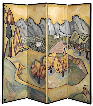
THE ALPILLES MASSIF PAINTED BY ROGER FRY

https://wanderingvertexes.blogspot.com/2020/11/the-alpilles-massif-painted-by-roger-fry.html


ROGER FRY (1866 -1934)
Les Alpilles  / Les  Opies  (496 m-1,627ft)
France (Provence) 


In Les Alpilles - Provençal screen,  1913, Private collection  


The mountains   

The Alpilles massif is located in the south of France, in the Bouches-du-Rhône department (Provence-Alpes-Côte d'Azur region), about sixty kilometers north of Marseille. It extends along an east-west axis for about 25 km, from the Rhône valley to the Durance valley. Several summit areas make it up: - The main part of the massif, called the Alpilles (“Little Alps”), stretches from the Saint-Gabriel chapel in Tarascon to the road linking Aureille to Eygalières.

- Les Opies  (496 m-1,627ft) east of the Alpille, is made up of three small peaks: the crêtes des Opies, Mont Menu and Défends (municipalities of Eyguières, Lamanon and Aureille).
- The  Rochers de la Pène) are a narrow link stretching to the south of the massif from which it is separated by the departmental road 17 (Arles-Paradou) .
- Les Costières, located in the town of Saint-Martin-de-Crau, is a plateau that marks the southern limit of the massif. This one gains altitude as one progresses towards the north, and slopes steeply on the marshes of Baux, to the south of the rocks of Pène.
- Les Chainons are a set of low altitude peaks (around 50 meters) between Aureille and Montmajour characterized by the sets of valleys they shelter. The Caisses de Jean-Jean are perhaps the best known of those hills

- The Mont Gaussier (306m -1,004 ft), located south of the city of Saint-Rémy-de-Provence. Today, the place of passage of many hikers who cross it by the GR6, Mount Gaussier was very early used as habitat by protohistoric populations, before having at its summit a medieval castle, nowadays disappeared. Mount Gaussier is made of crystalline limestone, white and hard. One finds in the soil the trace of many fossils. This type of summit is characteristic of the Alpilles range of mountains, especially on the north face.


The painter
Roger Eliot Fry was an English painter and critic, and a member of the Bloomsbury Group. Establishing his reputation as a scholar of the Old Masters, he became an advocate of more recent developments in French painting, to which he gave the name Post-Impressionism. He was the first figure to raise public awareness of modern art in Britain, and emphasised the formal properties of paintings over the "associated ideas" conjured in the viewer by their representational content. He was described by the art historian Kenneth Clark as "incomparably the greatest influence on taste since Ruskin ... In so far as taste can be changed by one man, it was changed by Roger Fry". The taste Fry influenced was primarily that of the Anglophone world, and his success lay largely in alerting an educated public to a compelling version of recent artistic developments of the Parisian avant-garde.
As a painter Fry was experimental (his work included a few abstracts), but his best pictures were straightforward naturalistic portraits, although he did not pretend to be a professional portrait - painter. In his art he explored his own sensations and gradually his own personal visions and attitudes asserted themselves. His work was considered to give pleasure, 'communicating the delight of unexpected beauty and which tempers the spectator's sense to a keener consciousness of its presence'. Fry did not consider himself a great artist, 'only a serious artist with some sensibility and taste'. 

___________________________

2020 - Wandering Vertexes...
by Francis Rousseau

Wednesday, November 11, 2020

THE FALAISES D'ETRETAT PAINTED BY GEORGES BRAQUE

https://wanderingvertexes.blogspot.com/2020/11/the-falaises-detretat-painted-by.html
 

GEORGES BRAQUE (1882-1963)
The Falaises d'Etretat (70 to 90 m - 230 to 300 ft)
France (Normandie)

 In Les Falaises d'Etretat, 1930, oil on canvas

The cliffs 
The Falaise d'Etretat (Etretat Chalk Complex), as it is known, consists of a complex stratigraphy of Turonian and Coniacian chalks. Some of the cliffs are as high as 90 metres (300 ft).  Etretat is best known for its chalk cliffs, including three natural arches and a pointed formation called L'Aiguille (the Needle), which rises 70 m- 230 ft above the sea.  L'arche et L'aiguille  (The Ark and the Needle) above.  An underground river, then marine erosion formed a natural arch and a estimated 55 meter to 70 meters  high needle, relic piece of the cliff. Maurice Leblanc describes it in these terms in his novel The Hollow Needle (1909) "An enormous roach, more than eighty meters high, colossal obelisk, plumb on its granite base"  At his time, the site already attracted many tourists among them "lupinophiles" admirers of Arsene Lupine: American students came for the key to the cave, where the "gentleman burglar" had found the treasure of kings of France. 


The Painter
Georges Braque (1882-1963) was a major 20th-century French painter, collagist, draughtsman, printmaker and sculptor. His most important contributions to the history of art were in his alliance with Fauvism from 1905, and the role he played in the development of Cubism. Braque's work between 1908 and 1912 is closely associated with that of his colleague Pablo Picasso. Their respective Cubist works were indistinguishable for many years, yet the quiet nature of Braque was partially eclipsed by the fame and  notoriety of Picasso. Braque believed that an artist experienced beauty "… in terms of volume, of line, of mass, of weight, and through that beauty [he] interpret[s] [his] subjective impression".   He described "objects shattered into fragments... [as] a way of getting closest to the object...Fragmentation helped me to establish space and movement in space”. He adopted a monochromatic and neutral color palette in the belief that such a palette would emphasize the subject matter.  Although Braque began his career painting landscapes, during 1908 he, alongside Picasso, discovered the advantages of painting still lifes instead. Braque explained that he “... began to concentrate on still lifes, because in the still-life you have a tactile, I might almost say a manual space... This answered to the hankering I have always had to touch things and not merely see them... In tactile space you measure the distance separating you from the object, whereas in visual space you measure the distance separating things from each other. This is what led me, long ago, from landscape to still-life”  A still life was also more accessible, in relation to perspective, than landscape, and permitted the artist to see the multiple perspectives of the object. Braque's early interest in still lifes revived during the 1930s.
During the period between the wars, Braque exhibited a freer, more relaxed style of Cubism, intensifying his color use and a looser rendering of objects. However, he still remained committed to the cubist method of simultaneous perspective and fragmentation. In contrast to Picasso, who continuously reinvented his style of painting, producing both representational and cubist images, and incorporating surrealist ideas into his work, Braque continued in the Cubist style, producing luminous, other-worldly still life and figure compositions. By the time of his death in 1963, he was regarded as one of the elder statesmen of the School of Paris, and of modern art.

Sunday, November 1, 2020

MOUNT GERIZIM BY FÉLIX BONFILS


FÉLIX BONFILS (1831-1885) Mount Gerizim (881m - 2,890 ft) Palestine  In Mount Gerizim from Mount Ebal - Maison Bonfils, Oregon State University

FÉLIX BONFILS (1831-1885)
Mount Gerizim (881m - 2,890 ft)
Palestine

In Mount Gerizim from Mount Ebal - Maison Bonfils, Oregon State University

The mountain
Mount Gerizim or Garizim or Ar-garízim in Hebrew, Jabal Jarizīm in Arabic is a West Bank mountain near Nablus, in the historic region of Samaria. This mountain is a holy place for the Samaritans, who can argue that it is mentioned several times in the Torah. The height of Mount Gerizim is 881 meters, very steep on its northern flank and covered with brush at the top. It is one of the highest mountains in the West Bank and Israel. At his feet springs a spring of fresh water.
Around -330 BC. AD, the Samaritan population built a temple at the top of the mountain that became the religious center of Samaritanism, like the Temple of Jerusalem for Judaism. This temple will be built a little before1 the conquest of Alexander the Great, or just after. The temple is then surrounded by fortifications (according to the Book of the Maccabees). However, it will be destroyed by King Hasmonean John Hyrcan I in the 2nd century BC (circa -108 BC) According to archaeological excavations and ancient sources, a temple dedicated to Zeus is built on the site. during the time of Emperor Hadrian. From its conversion to Christianity, the Byzantine Empire attempted to forcibly convert minorities (heterodox Christians or non-Christians) to its version of Christianity. Thus, the Emperor Zeno (born in 427 - reign from 474 to his death in 491) attacks the Jews and the Samaritans. During his reign, the Samaritan temple is destroyed a second time (in 484, it seems), and this, in a definitive way. It will never be rebuilt.
When Christianity became the dominant religion in the Roman Empire, the Samaritans were denied access to Mount Gerizim. A church, protected by ramparts, was built at the top. This was one of the causes of the Samaritan revolt under the leadership of Julianus ben Sabar in the sixth century, a revolt whose repression will be so terrible that the Samaritans, then very numerous in the north of Palestine, became a small residual population. Despite the destruction of the temple, the mountain has remained the religious center of the Samaritans until today. This is how the Samaritan high priest is to reside around Mount Gerizim. This one is chosen within the priestly family (or "house") which is "supposed to descend from the son of Aaron, brother of Moses".


The photographer
Félix Bonfils wasborn in Saint-Hippolyte-du-Fort (France). He moved to Beirut in 1867 where he opened with his wife and his son Adrien, the photographic workshop Maison Bonfils, he renamed in 1878 F. Bonfils and Co..
Bonfils photographed in Lebanon, Egypt, Palestine, Syria and Greece as well as in Constantinople from 1876.
He was very active as soon as he arrives in Lebanon: his catalog mentions more than 15,000 prints in the early 1870s, made from nearly 200 negatives, and 9,000 stereoscopic views.
His works became famous thanks to tourists from the Middle East who brought his photographs as souvenirs. His views could be purchased individually, but they were also available as albums.
However, these photographs, produced by the workshop, could sometimes be the work of his son Adrien or assistants of the company.
In 1876 he returned to Alès (France), where he opened another studio around 1881. The one of Beirut was not closed. His wife Marie-Lydie and his son kept it opened and active after this death in 1885. This establishment was still very active in 1905, when a fire destroyed it.
The Bonfils business continued for several decades after the death of its founder. It was bought in 1918 by Abraham Guiragossian, a partner since 1909, who kept its name. It is mentioned in the Blue Guide in 1932.

___________________________________
2020 - Wandering Vertexes
A blog by Francis Rousseau

Sunday, October 25, 2020

MUIR GLACIER PAINTED BY THOMAS HILL

THOMAS HILL (1829-1908) Muir Glacier (90 m - 200 ft) United States of America ( Alaska)


THOMAS HILL (1829-1908)
Muir Glacier (90 m - 200 ft)
United States of America ( Alaska)

In Muir Glacier, Alaska. oil on canvas, Oakland Museum of California

The Glacier
Muir Glacier is a glacier in Glacier Bay National Park and Preserve in the U.S. state of Alaska. It is currently about 0.7 km (0.43 mi) wide at the terminus. As recently as the mid-1980s the glacier was a tidewater glacier and calved icebergs from a wall of ice 90 m (200 feet) tall.
The glacier is named after Scottish-born naturalist John Muir, who traveled around the area and wrote about it, generating interest in the local environment and in its preservation. His first two visits were in 1879 (at age 41) and 1880. During the visits, he sent an account of his visits in installments to the San Francisco Bulletin. Later, he collected and edited these installments in a book, Travels in Alaska, published in 1915, the year after he died.
Muir Glacier has undergone very rapid, well-documented retreat since its Little Ice Age maximum position at the mouth of Glacier Bay around 1780. In 1794, the explorer Captain George Vancouver found that most of Glacier Bay was covered by an enormous ice sheet, some 1,200 meters (3,900 ft) in places.
In 1904 the glacier reportedly "broke through the mountains" with Pyramid Peak to the west and Mt. Wright and Mount Case to the east.
From 1892 to approximately 1980, it had retreated nearly 32 kilometers (20 mi). Between 1941 and 2004, the glacier retreated more than 12 kilometers (7.5 mi) and thinned by over 800 meters (2,600 ft). Ocean water has filled the valley replacing the ice and creating Muir Inlet.


The painter
Thomas Hill was an American artist of the 19th century. He produced many fine paintings of the California landscape, in particular of the Yosemite Valley, as well as the White Mountains of New Hampshire. Hill’s work was often driven by a vision resulting from his experiences with nature. For Thomas Hill, Yosemite Valley and the White Mountains of New Hampshire were his sources of inspiration to begin painting and captured his direct response to nature.
Hill was loosely associated with the Hudson River School of painters. The Hudson River School celebrated nature with a sense of awe for its natural resources, which brought them a feeling of enthusiasm when thinking of the potential it held. Mainly the earlier members of the Hudson River School, around the 1850-60’s, displayed man as in unison with nature in their landscape paintings by often painting men on a very small scale compared to the vast landscape. Thomas Hill often brought this technique into his own paintings in for example in his painting, Yosemite Valley, 1889.
He made early trips to the White Mountains with his friend Benjamin Champney and painted White Mountain subjects throughout his career. An example of his White Mountain subjects is Mount Lafayette in his Mount Lafayette in Winter.
Hill acquired the technique of painting en plein air. These paintings in the field later served as the basis for larger finished works. In plein air means to “paint outdoors and directly from the landscape”,[ which Hill incorporated into many of his paintings. Hill’s landscape paintings demonstrate how he combined his powers of observation with powerful motifs in each painting.
Hill’s move to California in 1861 brought him new material for his paintings. He chose monumental vistas, like Yosemite. During his lifetime, Hill’s paintings were popular in California, costing as much as $10,000. Hill's best works are considered to be these monumental subjects, including Great Canyon of the Sierra, Yosemite, Vernal Falls and Yosemite Valley.

___________________________________________

2020 - Wandering Vertexes...
by Francis Rousseau