google.com, pub-0288379932320714, DIRECT, f08c47fec0942fa0 GRAVIR LES MONTAGNES... EN PEINTURE

Tuesday, February 1, 2022

THE GRINDELWALD GLACIER PAINTED BY THOMAS FEARNLEY

THOMAS FEARNLEY  (1802-1842) The Grindelwald Glacier  (1, 349 m - 4, 425m) Switzerland   In The Grindelwald Glacier, oil on canvas  1838, 194 x 157 cm, Nasjonalmuseet, Oslo

 
THOMAS FEARNLEY  (1802-1842)
The Grindelwald Glacier  (1, 349 m - 4, 425m)
Switzerland (Bernese Alps)

 In The Grindelwald Glacier, oil on canvas  1838, 194 x 157 cm, Nasjonalmuseet, Oslo


About the painting
In The Grindelwaldgletscher, the highlight of Thomas Fearnley’s Swiss landscape paintings, the viewer gazes up from the grassy knoll in the foreground toward the bottom of a valley filled by a glacier. The majestic composition is based on Fearnley’s on-site observations. A sketch in pencil from August 1835 reveals a barren landscape in front of the glacier. The large trees, which form such an essential part of the picture’s overall composition, stem from studies of trees Fearnley made a week later in Scheideck. Fearnley has made the landscape more overpowering than in the original on-site drawing. The mountainsides are steeper and have been accentuated through light and shadow. The contrast to the everlasting ice and snow of the desolate valley is heightened by the lush vegetation in the foreground, where sheep graze under a shepherd’s supervision. Fearnley emphasizes the wild, inaccessible aspects of nature by letting a bird of prey glide above the glacier, even as he playfully includes a visual, English-based pun on his name by adding a tuft of fern next to his signature.
Scholars have noted how the composition and the balancing of the various landscape elements evoke the Düsseldorf painter Johann Wilhelm Schirmer (1807–63), whom Fearnley met during his sojourn in Switzerland. In romanticism, a pronounced contrast between warm and cold tones, as seen here, was also perceived as symbolizing the confrontation between life and death. Before the painting was completed, it was shown at the Paris Salon in 1836. Along with two paintings by J. C. Dahl, this painting and Fearnley’s The Labro Falls at Kongsberg (1837) were the first paintings by Norwegians artists to be acquired by the National Gallery.

The glacier
The Lower Grindelwald Glacier also known as the Lower Grindelwald Glacier is a glacier in the Bernese Alps, located southeast of Grindelwald, in the canton of Bern (Swiss). It originates under the Agassizhorn and the Strahlegghorn and is connected to the Unteraar glacier via the Finsteraarjoch (3,283 m). The Lower Grindelwald Glacier should not be confused with the Upper Grindelwald Glacier, located to the northeast. The Lower Grindelwald Glacier still has a major tributary, the Ischmeer (“sea of ​​ice” in Swiss German, formerly known as the “Grielwald-Fiescher Glacier”, German: Grindelwald-Fieschergletscher3), which is the glacier overlooked by the Eismeer station of the Jungfrau Railway.
The Lower Grindelwald Glacier was 8.3 km long and covered an area of ​​20.8 km2 in 1973. It has shrunk considerably since, being only 6.2 km long in 2015, the 1.9 km retreat being mainly intervened since 2007. In the middle of the 19th century, the glacier reached the valley of Grindelwald as far as Mettenberg, at an altitude of 983 m, near the confluence of the white Lütschine and the black Lütschine. In 1900 it still extended to the Rotenflue (1,200 m) and filled the whole valley from its present end, the glacial lake, with a thickness of about 300 m up to an altitude of 1,700 m, just below the current hiking trail around the Bänisegg. In the early 2000s, it had retreated to the gorge between the Hörnli (Eiger) ridge and the Mättenberg. 

The painter
Thomas Fearnley attended National Cadet Corps from 1814 to 1819. He was a student of the Norwegian National Academy of Craft and Art Industry (1819–1821), Art Academy in Copenhagen (1821–1823) and the Art Academy (n Stockholm (1823–27) under Carl Johan Fahlcrantz. Fearnley left Copenhagen bound for Stockholm in the autumn of 1823 to complete a painting commissioned by Crown Prince Oscar of Norway and Sweden. He received several orders from the Swedish royal family and from other members of the royal court including Swedish Count Gustaf Trolle-Bonde. He conducted study tours in Norway (1824-1826), at which time he met Johan Christian Dahl in Sogn. After another stay in Copenhagen from 1827 to 1828 and a new Norwegian trip in the autumn of 1828, he went to Germany and was a student of Dahl in Dresden (1829–1830) as well as befriending the German painter Joseph Petzl and the German-Danish painter Friedrich Bernhard Westphal. He lived in Munich (1830–32). Fearnley traveled extensively in the 1830s, visiting Munich, Paris, London, Hull and the English Lake district. During September 1832, he went from Venice to Rome and visited Sicily the following summer. He mostly painted in small towns south of Naples: Castellammare, Amalfi, Sorrento, Capri and in Switzerland: Meiringen, Grindelwald. He went to Paris in the summer of 1835 and visited London the next year. During the summer of 1839 he was on a study tour to the Sognefjord and Hardangerfjord, together with the German painter Andreas Achenbach. Fearnley's paintings alternate between oil sketches and larger, composed landscapes meant for exhibition. His large studio compositions have a cool monumental attitude with a taste for the powerful and wildly romantic in the favorite motifs, wilderness and waterfalls, and with a strong emphasis on the image's architectural structure. The National Gallery in Oslo owns a total of 54 of his smaller pictures and sketches and also a series of drawings. Notable works in this collection include Labrofossen (1837), Grindelwaldgletsjeren (1838) and Slinde Birken (1839). Other notable collections are located in the Bergen Kunstmuseum and the Nationalmuseum in Stockholm.

___________________________________________

2022 - Wandering Vertexes...
by Francis Rousseau

Saturday, January 29, 2022

LES DENTELLES DE MONTMIRAIL(2) SKETCHED BY A. G. CARRICK / H.M KING CHARLES III

A. G. CARRICK / H.M KING CHARLES III former PRINCE OF WALES (bn.1948)Les dentelle de Mont-Mirail- Crête de Saint Amand (722 m - 23,68ft) France (Vaucluse)  In View of Les Dentelles de Montmirail,  watercolor, 1993, Private collection


A. G. CARRICK / H.M KING CHARLES III former PRINCE OF WALES (bn.1948)
Les Dentelles de Montmirail  (722 m - 23,68ft)
France (Vaucluse)

In View of Les Dentelles de Montmirail,  watercolor, 1993, Private collection


The mountains
The Dentelles de Montmirail (722 m - 23,68ft) are a small chain of mountains in Provence in France, in the département of Vaucluse, located just to the south of the village of Vaison-la-Romaine. They are foothills of the highest peak in Provence, Mont Ventoux, which is situated just to the east. The dramatically jagged shape of their peaks was formed by horizontal strata of Jurassic limestone being folded and forced into a nearly upright position and subsequently eroded into sharp-edged ridges and spikes. The highest peak of the Dentelles is St-Amand, at 734 m (2,400 ft). The range, which is about 8 km wide, offers over 600 trails for walking, rock climbing, and mountain biking.]The foot of the Dentelles is surrounded by vineyards of the Rhône Valley. Their name Dentelles, the French word for "lace," refers to their shape obtained by erosion, while Montmirail is derived from the Latin mons mirabilis meaning 'admirable mountain'.
Located on the territory of the communes of Beaumes-de-Venise, Crestet, Gigondas, La Roque-Alric, Lafare, Le Barroux, Malaucène, Suzette, and Vacqueyras; the Dentelles de Montmirail were an important natural frontier during Antiquity between the tribes of the Memini in the south, and the Voconces in the north.

The painter
Arthur George Carrick is actually H.M. the King Charles III, former Prince of Wales.
When he began showing his paintings, he was too nervous to display his name so displayed under a pseudonym. Arthur George are two of his names (Charles Phillip Arthur George) and one of his titles is Earl of Carrick. King Charles III is an experienced watercolourist.  He has been painting for most of his adult life, during holidays or when his official diary allows. King Charles' interest began during the 1970s and 1980s when he was inspired by Robert Waddell, who had been his art master at Gordonstoun in Scotland. In time, King Charles met leading artists such as Edward Seago, with whom he discussed watercolour technique, and received further tuition from John Ward, Bryan Organ and Derek Hill.
The Royal Family has a tradition of drawing and painting, and King Charles’ work first came to public notice at a 1977 exhibition at Windsor Castle at which other Royal artists included Queen Victoria, The Duke of Edinburgh and The Duke of York.
King Charles paints in the open air, often finishing a picture in one go and his favourite locations include The Queen's estate at Balmoral in Scotland and Sandringham House in Norfolk, England. Sometimes King Charles  III paints during his skiing holidays, and during overseas tours when possible.
The copyright of King Charles' watercolours belongs to A. G. Carrick Ltd, a trading arm of The King's Charities Foundation. Over the years King Charles III has agreed to exhibitions of his watercolours and of lithographs made from them, on the understanding that any income they generate goes to The Prince of Wales's Charitable Foundation.
Money from the sale of the lithographs also goes to the Foundation but the paintings themselves are never for sale.
In the 1980s King Charles III, then Prince of Wales,  began inviting young British artists to accompany him on official tours overseas and record their impressions, a tradition that has continued to this day.
Reference :
- The prince of Wales paintings 
___________________________________________

2022 - Wandering Vertexes...
by Francis Rousseau

Wednesday, January 26, 2022

GUNUNG BROMO (2) PAINTED BY SUDJONO ABDULLAH

SUDJONO ABDULLAH (1911-1993) Gunung Bromo (2,329m - 7,641ft) Indonesia (Java Timur)  In Sawa Landscape, 1959, oil on canvas, Private collection

SUDJONO ABDULLAH (1911-1993)
Gunung Bromo (2,329m - 7,641ft)
Indonesia (Java Timur)

In Sawa Landscape, 1959, oil on canvas, Private collection

The volcano
Gunung Bromo (2,329m - 7,641ft) or Gunung Brama, an active volcano,in East Java, Indonesia, is not the highest peak of the Tengger massif, but the best known. The massif area is one of the most visited tourist attractions in East Java, Indonesia. The volcano belongs to the Bromo Tengger Semeru National Park. The name of Bromo derived from Javanese pronunciation of Brahma, the Hindu creator god. Gunung Bromo sits in the middle of a plain called the "Sea of Sand" a protected nature reserve since 1919. The best way to visit Gunung Bromo is from the nearby mountain village of Cemoro Lawang, from where it is possible to walk during 45 mn to the volcano. It is also possible to take an organised jeep tour, which includes a stop at the viewpoint on Gunung Penanjakan (2,770 m - 9,088 ft). On the fourteenth day of the Hindu festival of Yadnya Kasada, the Tenggerese people of Probolinggo, East Java, travel up the mountain in order to make offerings of fruit, rice, vegetables, flowers and sacrifices to the mountain gods by throwing it into the caldera of the volcano. The origin of the ritual lies in the 15th century legend when princess Roro Anteng started the principality of Tengger with her husband, Joko Seger. The couple were childless and therefore beseeched the assistance of the mountain gods. The gods granted them 24 children but stipulated that the 25th child, named Kesuma, must be thrown into the volcano as a human sacrifice. The gods' request was implemented. The tradition of throwing sacrifices into the volcano to appease these ancient deities continues today and is called the Yadnya Kasada ceremony. Though fraught with danger, some locals risk climbing down into the crater in an attempt to recollect the sacrificed goods that they believe could bring them good luck.
Depending on the degree of volcanic activity, the Indonesian Centre for Volcanology and Disaster Hazard Mitigation sometimes issues warnings against visiting Mount Bromo.
Mount Bromo recently erupted in 2004, 2010, 2011 and 2015.
 

The painter
Raden Soedjono Abdullah was born in Yogyakarta, the son of Abdullah Suriosubroto, a famous landscape painter and was also the brother of Basoeki Abdullah. He used to help his father cleaning the pallet from which he found his way to be a painter. He finished his school from HIS Indonesian Dutch School and worked as a poster artist for the Rex Theater in Yogyakarta. During the Japanese colonization in Indonesia, Sudjono went to Parangtritis, Parangkusumo where he continued to paint. During the 1970s, Soedjono moved to Kertosono in East Java, where he lived up to his death.

___________________________________________

2022 - Wandering Vertexes...
by Francis Rousseau

Sunday, January 23, 2022

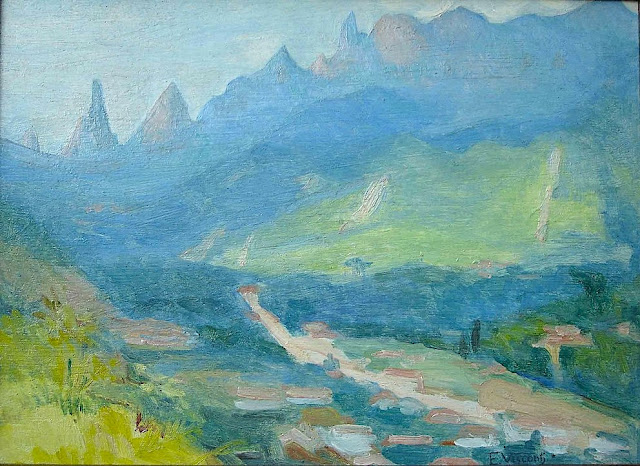
DEDO DE DEUS (2) PAINTED BY ELISEU VISCONTI

ELISEU VISCONTI (1866-1944) Dedo de Deus (1,682m - 5,551ft) Brazil


ELISEU VISCONTI (1866-1944)
Dedo de Deus (1,682m - 5,551ft)
Brazil


About this mainting
Eliseu Visconti painted a lot of times,the Dedo De Deus mountain in the Serra de Orgaos, in any season and in all possible light, at any time of day. It is THE  repetitive motif in his work, a bit like the Montagne Sainte-Victoire for Paul Cézanne or  the volcano Chimborazo for Frederic Edwin Church or Mount Everest for Nicholas Roerich.


The mountain
Dedo de Deus (The Finger of God) (1,682m - 5,551ft) is a peck whose outline resembles a hand pointing the index finger to the sky. It is one of the several geological monuments of Serra dos Órgãos which is located in Serra do Mar, between the cities of Petrópolis, Guapimirim and Teresópolis, in the state of Rio de Janeiro, in Brazil. The mountaineering in Brazil is closely linked to the achievement of the Dedo de deus. The peak is a state symbol Rio de Janeiro, appearing on its flag and coat of arms. As for the coat of arms of the State of Rio de Janeiro, the first section, occupying the upper half, is blue, representing the sky and symbolizing justice, truth and loyalty, with the silhouette of the Serra dos Órgãos, highlighting the Dedo de Deus. The symbol was created by the 1892 State Constitution and made official under the government of José Tomás da Porciúncula, with small differences over time. In 1912, José Guimarães Teixeira, Raul Carneiro and the brothers Américo, Alexandre and Acácio de Oliveira, all from Teresópolis, were the first to step on top of the rock formation.


The artist
Eliseu Visconti, born Eliseo d'Angelo Visconti was an Italian-born Brazilian painter, cartoonist, and teacher. He is considered one of the very few impressionist painters of Brazil. He is considered the initiator of the art nouveau in Brazil.
Thanks to a prize received in 1892, Visconti travelled to Paris, where he attended the École des Beaux Arts the following year. He also took classes at the Académie Julian and the École nationale supérieure des arts décoratifs, where he was a pupil of art nouveau master Eugène Grasset. He was accepted at the Salon de la Nationale des Beaux Arts and at the Salon of the Société of des Artistes Français. As one of the Brazilian representatives to the Exposition Universelle 1900 he exhibited the paintings Gioventú and Oréadas, for which he received a silver medal. Back in Brazil, Visconti exhibited in Rio de Janeiro and São Paulo, and obtained the first place in a contest for the drawing of postal stamps for the Brazilian Casa da Moeda. He traveled again to Europe, where he exhibited at the Paris Salon of 1905 the portrait of the artist Nicolina Vaz de Assis now at the Museu Nacional de Belas Artes. In this same year, he was invited to paint the stage curtain for the Teatro Municipal of Rio de Janeiro which he completed in his studio in Paris.
Decorative schemes executed for the National Library or Biblioteca Nacional in (Rio de Janeiro) date from this period as does another gold medal he received at the International Exhibition of Saint-Louis (Louisiana Purchase Exposition), in 1904, for the painting Recompensa de São Sebastião (see external links). The museum of Santiago of the Chile acquired his Sonho Místico (Mystical Dream) in 1912. In 1913, Visconti returned to Europe in order to paint large scale panels for the "foyer" of the Theatro Municipal do Rio de Janeiro. His plans to return were interrupted by the First World War so he stayed in France until 1920. The resulting paintings for the "foyer" were sent to Brazil during the war, in 1915. In 1922 his triptych "Lar" gained him the Medal of Honor in a large exhibition created in Rio de Janeiro to commemorate the first centennial of Brazilian Independence, the Exposição do Centenário. The following year Visconti painted the mural decoration of Rio de Janeiro's municipal council hall. In 1924, he painted the panel depicting the signature of the first Republican Constitution, for the old federal court, also in Rio de Janeiro.
_______________________________

2022 - Wandering Vertexes...
by Francis Rousseau
Thursday, January 20, 2022

CATHEDRAL PEAK PAINTED BY JACOBUS HENDRIK PIERNEEF


JACOBUS HENDRIK PIERNEEF (1886-1957)
Cathedral Peak (3,004 m - 9,856 ft)
South Africa (Natal)

The mountain
Cathedral Peak is a mountain in KwaZulu-Natal, South Africa. It is a 3,004 m (9,856 ft) high free standing mountain in the Drakensberg. The mountain is also known as Mponjwana (Little Horn) by the local Amangwanepeople. Cathedral Peak is part of the Cathedral Ridge which is at right angles to the main range. Other peaks in the spur are the Twins, also known as the Triplets, (2,899 m or 9,510 feet), the Bell (2,930 m or 9,800 feet), the Outer (3,006 m or 9,860 feet) and Inner (3,005 m or 9,858 feet) Horns, the Chessmen (2,987 m or 9,800 feet) and Mitre Peak (3,023 m or 9,919 feet).
Cathedral Peak was first climbed by D.W. Basset-Smith and R.G. Kingdon in 1917, via the gully.


The painter
Jacobus Hendrik (Henk) Pierneef (usually referred to as Pierneef) was a South African landscape artist, generally considered to be one of the best of the old South African masters. His distinctive style is widely recognized and his work was greatly influenced by the South African landscape.
Most of his landscapes were of the South African highveld, which provided a lifelong source of inspiration for him. Pierneef's style was to reduce and simplify the landscape to geometric structures, using flat planes, lines and colour to present the harmony and order in nature. This resulted in formalised, ordered and often-monumental view of the South African landscape, uninhabited and with dramatic light and colour.
Pierneef's work can be seen worldwide in many private, corporate and public collections, including the Africana Museum, Durban Art Gallery, Johannesburg Art Gallery, King George VI Art Gallery, Pierneef Museum and the Pretoria Art Gallery.

___________________________

2022 - Wandering Vertexes...
by Francis Rousseau

Monday, January 17, 2022

FUJIYAMA BY KIYOSHI SAITO

KIYOSHI SAITO / 斎藤 清 (1907-1997) Fujiyama / 富士山 (3, 776 m -12,389 ft) Japan  In Mt. Fuji in Sunset Glow, 1986, woodcut , 45.2 x 61.5 cm, Private collection

KIYOSHI SAITO / 斎藤 清 (1907-1997)
Fujiyama / 富士山 (3, 776 m -12,389 ft)
Japan

In Mt. Fuji in Sunset Glow, 1986, woodcut , 45.2 x 61.5 cm, Private collection

The painter
Kiyoshi Saitō (斎藤 清) born in Aizubange, Fukushima) was a sōsaku-hanga artist in 20th-century Japan. In 1938, he issued his first prints in his now famous "Winter in Aizu" series. Saitō was one of the first Japanese printmaking artists to have won at the São Paulo Biennale in 1951. Saitō's early works depict villages populated with local Japanese with a high degree of realism and three-dimensionality. His more mature works merge modern elements with Japanese tradition. His prints feature architecture and plant life flattened in two-dimensionality.  He spent time in Paris, and did a series there. Kiyoshi Saito’s woodblock prints titled “Autumn” are considered extremely rare and valuable.


The mountain

The legendary Mount Fuji or Fujiyama (富士山) is located on Honshu Island and is the highest mountain peak in Japan at 3,776.24 m (12,389 ft). Several names are attributed to it: "Fuji-san", "Fujiyama" or, redundantly, "Mt. Fujiyama". Usually Japanese speakers refer to the mountain as "Fuji-san". The other Japanese names for Mount Fuji, have become obsolete or poetic like: Fuji-no-Yama (ふじの山 - The Mountain of Fuji), Fuji-no-Takane (ふじの高嶺- The High Peak of Fuji), Fuyō-hō (芙蓉峰 - The Lotus Peak), and Fugaku (富岳/富嶽), created by combining the first character of 富士, Fuji, and 岳, mountain.
Mount Fuji is an active stratovolcano that last erupted in 1707–08. Mount Fuji lies about 100 kilometres (60 mi) south-west of Tokyo, and can be seen from there on a clear day.
Mount Fuji's exceptionally symmetrical cone, which is snow-capped several months a year, is a well-known symbol of Japan and it is frequently depicted in art and photographs, as well as visited by sightseers and climbers.
Mount Fuji is one of Japan's Three Holy Mountains (三霊山) along with Mount Tate and Mount Haku. It is also a Special Place of Scenic Beauty and one of Japan's Historic Sites.
It was added to the World Heritage List as a Cultural Site on June 22, 2013. As per UNESCO, Mount Fuji has “inspired artists and poets and been the object of pilgrimage for centuries”. UNESCO recognizes 25 sites of cultural interest within the Mt. Fuji locality. These 25 locations include the mountain itself, Fujisan Hongū Sengen Shrine and six other Sengen shrines, two lodging houses, Lake Yamanaka, Lake Kawaguchi, the eight Oshino Hakkai hot springs, two lava tree molds, the remains of the Fuji-kō cult in the Hitoana cave, Shiraito Falls, and Miho no Matsubara pine tree grove; while on the low alps of Mount Fuji lies the Taisekiji temple complex, where the central base headquarters of Nichiren Shoshu Buddhism is located.

______________________________

2022 - Wandering Vertexes...
by Francis Rousseau

Friday, January 14, 2022

KANGCHENJUNGA PHOTOGRAPHED IN 1891 BY KURT BOECK

KURT BOECK (1855-1933) Kangchenjunga (8, 538m - 28,169 ft) India, Népal   In Kinchinjunga aus Südosten,  photo, 1891, Privtate coillection


KURT BOECK (1855-1933)
Kangchenjunga (8, 538m - 28,169 ft)
India, Népal 

In Kinchinjunga aus Südosten,  photo, 1891, Private coillection 


The artist
Kurt Karl Alexander Oskar Boeck was a German theater actor, climber, travel writer ans eventually early photographer. He began as an actor but in 1887when he had the opportunity to accompany a research expedition to Asia, especially to Persia and the Caucasus, he could not resist the temptation.
Researching and traveling in lesser-known, far-off lands told him so much that when he returned home from Asia he did not find a commitment that suited his wishes, he turned completely to this interesting profession. First, Boeck undertook in 1890 at his own expense an expedition to the Himalayas, where he took the glacier leader Hans Kerner from Tyrol and drove in the years 1893, 1895 and 1898-1899 again to India to thoroughly get to know the country in all parts. Boeck's lectures in numerous national and international associations on these and his other travels in Burma, China, America, Japan, Siberia, etc., have made him, as well as his articles in magazines, known to the general public.

The mountain
Kangchenjunga (8,586 m (28,169 ft) is the third highest mountain in the world. It lies partly in Nepal and partly in Sikkim, India. Kangchenjunga is the second highest mountain of the Himalayas after Mount Everest. Three of the five peaks – Main, Central and South – are on the border between North Sikkim and Nepal. Two peaks are in the Taplejung District, Nepal.
Kangchenjunga Main is the highest mountain in India, and the easternmost of the mountains higher than 8,000 m (26,000 ft). Until 1852, Kangchenjunga was assumed to be the highest mountain in the world, but calculations based on various readings and measurements made by the Great Trigonometrical Survey of India in 1849 came to the conclusion that Mount Everest, known as Peak XV at the time, was the highest. It is listed int the Eight Thousanders and as Seven Third Summits
Kangchenjunga is the official spelling adopted by Douglas Freshfield, A. M. Kellas, and the Royal Geographical Society that gives the best indication of the Tibetan pronunciation. Freshfield referred to the spelling used by the Indian Government since the late 19th century. There are a number of alternative spellings including Kangchendzцnga, Khangchendzonga, and Kanchenjunga. Local Lhopo people believe that the treasures are hidden but reveal to the devout when the world is in peril; the treasures comprise salt, gold, turquoise and precious stones, sacred scriptures, invincible armor or ammunition, grain and medicine. Kangchenjunga's name in the Limbu language is Senjelungma or Seseylungma, and is believed to be an abode of the omnipotent goddess Yuma Sammang.
It rises in a section of the Himalayas called Kangchenjunga Himal that is limited in the west by the Tamur River, in the north by the Lhonak Chu and Jongsang La, and in the east by the Teesta River. It lies about 128 km (80 mi) east of Mount Everest.
Allowing for further verification of all calculations, it was officially announced in 1856 that
Kangchenjunga was first climbed on 25 May 1955 by Joe Brown and George Band, who were part of a British expedition. They stopped short of the summit as per the promise given to the Chogyal that the top of the mountain would remain inviolate. Every climber or climbing group that has reached the summit has followed this tradition. Other members of this expedition included John Angelo Jackson and Tom Mackinon. In May 1979, Doug Scott, Peter Boardman and Joe Tasker established a new route on the North Ridge their third ascent which was the first one ever made without oxygen.
In 1983, Pierre Beghin made the first solo ascent accomplished without the use of supplemental oxygen. In 1992, Wanda Rutkiewicz was the first woman in the world to ascend and descend K2 and a world-renowned Polish climber, died after she insisted on waiting for an incoming storm to pass, which she did not survive. In 1998, Ginette Harrison was the first woman who climbed Kangchenjunga North face ; Gerlinde Kaltenbrunner, an Austrian mountaineer, was the second woman to reach the summit in 2006. In May 2014, the Bulgarian diabetic climber Boyan Petrov reached the peak without the use of supplemental oxygen

_______________________________
2022 - Wandering Vertexes...
by Francis Rousseau

Wednesday, January 12, 2022

BELUKHA MOUNTAIN (2) PAINTED BY NICHOLAS ROERICH


NICHOLAS ROERICH (1874-1947) Belukha Mountain (4,506 m, 14,784 ft) Russia-Kazakhstan, border    In  Path to Shambhala, oil on canvas,  1933,  Roerich Museum NYC

NICHOLAS ROERICH (1874-1947)
Belukha Mountain (4,506 m - 14,784 ft)
Russia - Kazakhstan border 

 In  Path to Shambhala, oil on canvas, 1933,  Roerich Museum NYC


About Shambala
Nicholas and Helena Roerich led a 1924–1928 expedition aimed at Shambhala. They also believed that Belukha Mountain in the Altai Mountains was an entrance to Shambhala, a common belief of that region. Inspired by Theosophical lore and several visiting Mongol lamas, Gleb Bokii, the chief Bolshevik cryptographer and one of the bosses of the Soviet secret police, along with his writer friend Alexander Barchenko, embarked on a quest for Shambhala, in an attempt to merge Kalachakra-tantra and ideas of Communism in the 1920s. Among other things, in a secret laboratory affiliated with the secret police, Bokii and Barchenko experimented with Buddhist spiritual techniques to try to find a key for engineering perfect communist human beings.  They contemplated a special expedition to Inner Asia to retrieve the wisdom of Shambhala – the project fell through as a result of intrigues within the Soviet intelligence service, as well as rival efforts of the Soviet Foreign Commissariat that sent its own expedition to Tibet in 1924. French Buddhist Alexandra David-Néel associated Shambhala with Balkh in present-day Afghanistan, also offering the Persian Sham-i-Bala, "elevated candle" as an etymology of its name.  In a similar vein, the Gurdjieffian J. G. Bennett published speculation that Shambalha was Shams-i-Balkh, a Bactrian sun temple.


The mountain

Belukha Mountain located in the Katun Mountains, is the highest peak of the Altai Mountains in Russia and the highest of the system of the South Siberian Mountains. It is part of the World Heritage Site entitled Golden Mountains of Altai. Located in the Altai Republic, Belukha is a three-peaked mountain massif that rises along the border of Russia and Kazakhstan, just a few dozen miles north of the point where this border meets with the border of China. There are several small glaciers on the mountain, including Belukha Glacier. Of the two peaks, the eastern peak (4,506 m, 14,784 ft.) is higher than the western peak (4,440 m, 14,567 ft.). Belukha was first climbed in 1914 by the Tronov brothers. Most ascents of the eastern peak follow the same southern route as that taken in the first ascent. Though the Altai is lower in elevation than other Asian mountain groups, it is very remote, and much time and planning are required for its approach.
In the summer of 2001, a team of scientists traveled to the remote Belukha Glacier to assess the feasibility of extracting ice cores at the site. Research was carried out from 2001 to 2003: both shallow cores and cores to bedrock were extracted and analyzed (Olivier and others, 2003; Fujita and others, 2004). Based on tritium dating techniques, the deeper cores may contain as much as 3,000–5,000 years of climatic and environmental records. A Swiss-Russian team also studied the glacier.
Since 2008, one is required to apply for a special border zone permit in order to be allowed into the area (if travelling independently without using an agency). Foreigners should apply for the permit to their regional FSB border guard office two months before the planned date.

The painter
Nicholas Roerich known also as Nikolai Konstantinovich Rerikh (Никола́й Константи́нович Ре́рих) is quite an important figure of mountain paintings in the early 20th century. He was a Russian painter, writer, archaeologist, theosophist, perceived by some in Russia as an enlightener, philosopher, and public figure. In his youth was he was quite influenced by a movement in Russian society around the occult and was interested in hypnosis and other spiritual practices. His paintings are said to have hypnotic expression.
Born in Saint Petersburg, Russia, he lived in various places around the world until his death in Naggar, Himachal Pradesh, India. Trained as an artist and a lawyer, his main interests were literature, philosophy, archaeology, and especially art. After the February Revolution of 1917 and the end of the czarist regime, Roerich, a political moderate who valued Russia's cultural heritage more than ideology and party politics, had an active part in artistic politics. With Maxim Gorky and Aleksandr Benois, he participated with the so-called "Gorky Commission" and its successor organization, the Arts Union (SDI).
After the October Revolution and the acquisition of power of Lenin's Bolshevik Party, Roerich became increasingly discouraged about Russia's political future. During early 1918, he, Helena, and their two sons George and Sviatoslav emigrated to Finland. After some months in Finland and Scandinavia, the Roerichs relocated to London, arriving in mid-1919. Later, a successful exhibition resulted in an invitation from a director at the Art Institute of Chicago, offering to arrange for Roerich's art to tour the United States. During the autumn of 1920, the Roerichs traveled to America by sea. The Roerichs remained in the United States from October 1920 until May 1923.
After leaving New York, the Roerichs – together with their son George and six friends – began the five-year-long 'Roerich Asian Expedition' that, in Roerich's own words: "started from Sikkim through Punjab, Kashmir, Ladakh, the Karakoram Mountains, Khotan, Kashgar, Qara Shar, Urumchi, Irtysh, the Altai Mountains, the Oyrot region of Mongolia, the Central Gobi, Kansu, Tsaidam, and Tibet" with a detour through Siberia to Moscow in 1926.
In 1929 Nicholas Roerich was nominated for the Nobel Peace Prize by the University of Paris. He received two more nominations in 1932 and 1935. His concern for peace resulted in his creation of the Pax Cultura, the "Red Cross" of art and culture. His work for this cause also resulted in the United States and the twenty other nations of the Pan-American Union signing the Roerich Pact on April 15, 1935 at the White House. The Roerich Pact is an early international instrument protecting cultural property.
In 1934–1935, the U.S. Department of Agriculture (then headed by Roerich admirer Henry A. Wallace) sponsored an expedition by Roerich and USDA scientists H. G. MacMillan and James F. Stephens to Inner Mongolia, Manchuria, and China.
Roerich was in India during the Second World War, where he painted Russian epic heroic and saintly themes, including: Alexander Nevsky, The Fight of Mstislav...
In 1942, Roerich received Jawaharlal Nehru at his house in Kullu. Together they discussed the fate of the new world: "We spoke about Indian-Russian cultural association, it is time to think about useful and creative cooperation ...”.
Gandhi would later recall about several days spent together with Roerich's family: "That was a memorable visit to a surprising and gifted family where each member was a remarkable figure in himself, with a well-defined range of interests." ..."Roerich himself stays in my memory. He was a man with extensive knowledge and enormous experience, a man with a big heart, deeply influenced by all that he observed". During the visit, "ideas and thoughts about closer cooperation between India and USSR were expressed. Now, after India wins independence, they have got its own real implementation[clarification needed]. And as you know, there are friendly and mutually-understanding relationships today between both our countries".
In 1942, the American-Russian cultural Association (ARCA) was created in New York.
Its active participants were Ernest Hemingway, Rockwell Kent, Charlie Chaplin, Emil Cooper, Serge Koussevitzky, and Valeriy Ivanovich Tereshchenko. The Association's activity was welcomed by scientists like Robert Millikan and Arthur Compton.
Roerich died on December 13, 1947.
Presently, the Nicholas Roerich Museum in New York City is a major institution for Roerich's artistic work. Numerous Roerich societies continue to promote his theosophical teachings worldwide. His paintings can be seen in several museums including the Roerich Department of the State Museum of Oriental Arts in Moscow; the Roerich Museum at the International Centre of the Roerichs in Moscow; the Russian State Museum in Saint Petersburg, Russia; a collection in the Tretyakov Gallery in Moscow; a collection in the Art Museum in Novosibirsk, Russia; an important collection in the National Gallery for Foreign Art in Sofia, Bulgaria; a collection in the Art Museum in Nizhny Novgorod Russia; National Museum of Serbia ; the Roerich Hall Estate in Nagar village in Kullu Valley, India; the Sree Chitra Art Gallery, Thiruvananthapuram, India;[17] in various art museums in India; and a selection featuring several of his larger works in The Latvian National Museum of Art.

_______________________________
2022 - Wandering Vertexes...
by Francis Rousseau

Sunday, January 9, 2022

MOUNT TARAWERA (2) PAINTED BY CHARLES BLOMFIELD


CHARLES BLOMFIELD (1848-1926) Mount Tarawera (1, 111m - 3,645ft)  New Zealand (North Island)    In  White Terraces, oil on canvas, 1882, Museum of New Zeland Te Papa Tongarewa

CHARLES BLOMFIELD (1848-1926)
Mount Tarawera (1, 111m - 3,645ft) 
New Zealand (North Island)

  In  White Terraces, oil on canvas, 1882, Museum of New Zeland Te Papa Tongarewa 

The full extraordinsary story  of this unbelievable volcano  in paintings is HERE


The mountain 
Mount Tarawera (1, 111m - 3,645ft) is the volcano responsible for one of New Zealand's largest historic eruptions. Located 24 kilometres southeast of Rotorua in the North Island, it consists of a series of rhyolitic lava domes that were fissured down the middle by an explosive basaltic eruption in 1886, which killed an estimated 120 people. These fissures run for about 17 kilometres northeast-southwest.
The volcano's component domes include Ruawahia Dome, Tarawera Dome and Wahanga Dome. It is surrounded by several lakes, most of which were created or drastically altered by the 1886 eruption. These lakes include Lakes Tarawera, Rotomahana, Rerewhakaaitu, Okataina, Okareka, Tikitapu (Blue Lake) and Rotokakahi (Green Lake). The Tarawera River runs northeastwards across the northern flank of the mountain from Lake Tarawera.
Main eruptions 
- 1315 : Mount Tarawera erupted for the fist time on modern history. The ash thrown from this event may have affected temperatures around the globe and precipitated the Great Famine of 1315–17 in Europe.
- 1886 : Shortly after midnight on the morning of 10 June 1886, a series of more than 30 increasingly strong earthquakes were felt in the Rotorua area and an unusual sheet lightning display was observed from the direction of Tarawera. At around 2:00 am a larger earthquake was felt and followed by the sound of an explosion. By 2:30 am Mount Tarawera's three peaks had erupted, blasting three distinct columns of smoke and ash thousands of metres into the sky (see painting above). At around 3.30 am, the largest phase of the eruption commenced; vents at Rotomahana produced a pyroclastic surge that destroyed several villages within a 6 kilometre radius, and the Pink and White Terraces appeared to be obliterated.
The eruption was heard clearly as far away as Blenheim and the effects of the ash in the air were observed as far south as Christchurch, over 800 km away. In Auckland the sound of the eruption and the flashing sky was thought by some to be an attack by Russian warships.
Although the official contemporary death toll was 153, exhaustive research by physicist Ron Keam only identified 108 people killed by the eruption. Much of the discrepancy was due to misspelled names and other duplications. Allowing for some unnamed and unknown victims, he estimated that the true death toll was 120 at most.  Some people claim that many more people died.
The eruption also buried many Māori villages, including Te Wairoa which has now become a tourist attraction (Buried Village of Te Wairoa) and the world-famous Pink and White Terraces were lost. A small portion of the Pink Terraces was rediscovered under Lake Rotomahana 125 years later. Approximately 2 cubic kilometres of tephra was erupted, more than Mount St. Helens ejected in 1980. Many of the lakes surrounding the mountain had their shapes and areas dramatically altered, especially the eventual enlargement of Lake Rotomahana, the largest crater involved in the eruption, as it re-filled with water.
Legend
One legend surrounding the 1886 eruption is that of the phantom canoe. Eleven days before the eruption, a boat full of tourists returning from the Terraces saw what appeared to be a war canoe approach their boat, only to disappear in the mist half a mile from them. One of the witnesses was a clergyman, a local Maori man from the Te Arawa iwi. Nobody around the lake owned such a war canoe, and nothing like it had been seen on the lake for many years. It is possible that the rise and fall of the lake level caused by pre eruption fissures had freed a burial waka (canoe) from its resting place. Traditionally dead chiefs were tied in an upright position. A number of letters have been published from the tourists who experienced the event.
Though skeptics maintained that it was a freak reflection seen on the mist, tribal elders at Te Wairoa claimed that it was a waka wairua (spirit canoe) and was a portent of doom. It has been suggested that the waka was actually a freak wave on the water, caused by seismic activity below the lake, but locals believe that a future eruption will be signaled by the reappearance of the canoe.


The painter 
 Charles Blomfield  was a New Zealand decorator, artist and music teacher born in London, England.
A widow, Blomfield's mother brought her family to New Zealand in the 1860's intending to settle in Northland as part of a settlement called Albertland. On arrival in Auckland they decided not to proceed on Northland to become farmers but to pursue urban trades in Auckland. The family remained in Auckland after that and many of the descendants of the various children still reside in the Auckland area.
Charles Blomfield lived in Freeman's Bay - 40 Wood Street, in a house built by his brother and allegedly made out of the timber from one large Kauri tree. As well as an exhibiting easel painter Blomfield worked as a sign-writer and interior decorator; for this trade he maintained studios in shops at various times. These were usually on Karangahape Road, one of these was shared with his daughter who made a living painting floral pieces which she also exhibited at the Auckland Society of Arts.
Blomfield travelled throughout the centre of the North Island on several occasions in the 1870s and 80s creating many landscape paintings of the New Zealand countryside, often for sale to visitors to New Zealand. He was fortunate to view the famed Pink and White Terraces several times and paint them before they were destroyed by the eruption of Tarawera in 1886. His meticulous sketches and finished paintings are some of the main records of them (see above).  For the remainder of his life he was probably able to rely on new versions of his classic views of them to supplement his income.
His paintings are widely regarded as the epitome of 19th century New Zealand landscape art, although his work, like many of his contemporaries, fell out of fashion during the 20th century, only to be re-evaluated in the 1970s. He was unable to come to terms with developments in art and remained staunchly conservative and hostile to 'modern art'. In his later years he found himself increasingly sidelined by the artistic circles in Auckland which he had previously shone in and was probably embittered by this.
Blomfield died at his residence in Wood Street in 1926. He was survived by several children. One of his brothers, William, was a noted newspaper cartoonist.
 Source : 
 
 _____________________________________
2022 - Wandering Vertexes...
Un blog de Francis Rousseau 

Thursday, January 6, 2022

MILESOVKA PAINTED BY CASPAR DAVID FRIEDRICH

CASPAR DAVID FRIEDRICH (1774-1840) Milešovka (837m - 2, 746ft) Czech Republic  In Mountain Landscape with Rainbow ca.1809-1810, Museum Folkwang, Essen, Germany


CASPAR DAVID FRIEDRICH (1774-1840)
Milešovka (837m - 2, 746ft)
Czech Republic

In Mountain Landscape with Rainbow ca.1809-1810, Museum Folkwang, Essen, Germany

 
The mountain
Milešovka (837m - 2, 746 ft), an isolated phonolite cone, is the highest mountain of České Středohoří (Czech Central Mountains Range), a picturesque mountain range in northwest Bohemia, in Czech Republic. Situated right in the middle of the European Continent, it has a volcanic origin. The range covers an area of more than 1000 km2 with many hills typically volcano shaped. Their unique appearance were attracting numbers of naturalists, painters, poets and nature-lovers.
Mount Milešovka is located over the village of Milesov about 10km northwestward of Lovosice. The peak is ranked among the most windy mountains in Czech Republic. The very first chalet had been built up in 1825, other buildings soon followed as well as the outlook tower in 1850. The famous traveler Alexander von Humboldt is responsible for their construction, he labeled the view from Milesovka as "the third most beautiful in the world", making it really worth visiting. From there, one can see the scenery view of Ceske Stredohori, the Polabska nizina lowlands and the ridge of the Krusne hory mountains. Milesovka adjoins with a peak called Paskapole which is crossed by the road connecting Prague with Teplice.


The painter
Caspar David Friedrich was a 19th-century German Romantic landscape painter, considered as the most important German artist of his generation. He is best known for his mid-period allegorical landscapes which typically feature contemplative figures silhouetted against night skies, morning mists, barren trees or Gothic ruins. His primary interest as an artist was the contemplation of nature, and his often symbolic and anti-classical work seeks to convey a subjective, emotional response to the natural world. Friedrich's paintings characteristically set a human presence in diminished perspective amid expansive landscapes, reducing the figures to a scale that, according to the art historian Christopher John Murray, directs "the viewer's gaze towards their metaphysical dimension".
Friedrich was born in Pomerania, where he began to study art. He studied in Copenhagen until 1798, before settling in Dresden. A disillusionment with materialistic society was giving rise everywhere in Europe. This shift in ideals was often expressed through a reevaluation of the natural world, as artists such as J. M. W. Turner (1775–1851) and John Constable (1776–1837) sought to depict nature as a "divine creation, to be set against the artifice of human civilization"....
- More informations about Caspar David Friedrich life and work 

 _____________________________________
2022 - Wandering Vertexes...
Un blog de Francis Rousseau

Monday, January 3, 2022

FALAISE DES VACHES NOIRES PAINTED BY GUSTAVE CAILLEBOTTE


GUSTAVE CAILLEBOTTE (1848-1894) Falaise des Vaches Noires (110 m- 360 ft) France (Normandie)   In Cliffs at Villers sur mer 1880, 65 x 81 cm, Private collection

GUSTAVE CAILLEBOTTE (1848-1894)
Falaise des Vaches Noires (110 m- 360 ft)
France (Normandie)

 In Cliffs at Villers sur mer 1880, 65 x 81 cm, Private collection


The cliffs
The Vaches Noires cliffs (Black Cows Cliffs)  (110 m- 360 ft)  is a remarkable natural site located in the municipalities of Houlgate, Gonneville-sur-Mer, Auberville, Villers-sur-Mer, in Calvados, in Normandy (France). The toponym "Black Cows" designates blocks of chalk having rolled from the top of the cliff on the foreshore, the black color of which is due to the kelp having attached itself to it.The Vaches Noires cliffs are made up of clay cliffs capped at their summit (altitude 110 m) with a thin chalk cliff.

This area is geologically remarkable. The Oxfordian marls, under the action of the water runoff from the aquifer which surmounts them, are notched by deep ravines. These are traversed by mud flows which advance slowly towards the sea and contain blocks of Cretaceous chalk coming from the summit. At high tide, the waves attack the front of the lava flows, releasing extremely varied fossils. The cliffs are made up of a succession of layers of clay, marl and chalk. Due to the risk of landslide and the fragility of the clay cliffs, the cliffs are now protected, their access has been prohibited by decree of classification as a "site of scientific and landscaped interest in the Calvados department" of 20 February 1995 from theFrench Ministry of the Environment.


The painter
The very important french painter Gustave Caillebotte, (known in US more than his own country) was a member and patron of the artists known as Impressionists,(or independents) although he painted in a more realistic manner than many others in the group. Caillebotte was noted for his early interest in photography as an art form.
With regard to the composition and painting style of his works, Caillebotte may be considered part of the first movement after Impressionism: Neo-Impressionism. The second period of Pointillism, whose main representative was Georges Seurat, announced its influence in the late works that Caillebotte painted at his country house in Petit Gennevilliers.
Caillebotte's style belongs to the School of Realism but was strongly influenced by his Impressionist associates. In common with his precursors Jean-François Millet and Gustave Courbet, as well his contemporary Degas, Caillebotte aimed to paint reality as it existed and as he saw it, hoping to reduce the inherent theatricality of painting. Perhaps because of his close relationship with so many of his peers, his style and technique vary considerably among his works, as if "borrowing" and experimenting, but not really sticking to any one style. At times, he seems very much in the Edgar Degas camp of rich-colored realism (especially his interior scenes); at other times, he shares the Impressionist commitment to "optical truth" and employs an impressionistic pastel-softness and loose brush strokes most similar to Renoir and Pissarro, although with a less vibrant palette.
The tilted ground common to these paintings is very characteristic of Caillebotte's work, which may have been strongly influenced by Japanese prints and the new technology of photography, although evidence of his use of photography is lacking. Cropping and "zooming-in", techniques that commonly are found in Caillebotte's oeuvre, may also be the result of his interest in photography, but may just as likely be derived from his intense interest in perspective effects. A large number of Caillebotte's works also employ a very high vantage point, including View of Rooftops - Snow (Vue de toits (Effet de neige) 1878, Boulevard Seen from Above (Boulevard vu d'en haut) 1880, and A Traffic Island (Un refuge, boulevard Haussmann), 1880.
Caillebotte is best known for his paintings of still life, water sports and urban Paris, The latter is almost unique among his works for its particularly flat colors and photo-realistic effect, which give the painting its distinctive and modern look, almost akin to American Realists such as Edward Hopper.

___________________________________________
2022 - Wandering Vertexes...
by Francis Rousseau

Saturday, January 1, 2022

THE MONT VENTOUX BY NICOLAS DE STAËL

NICOLAS DE STAËL (1914-1955) Mont Ventoux France  In Carte de vœux illustrée d’une lithographie en couleurs imprimée pour Fequet et Baudier. Feuillet ; 21 x 16, 5 cm.

NICOLAS DE STAËL (1914-1955)
Mont Ventoux (1,911 m - 6, 270 ft )
France (Provence)

In Carte de vœux illustrée from a colored  lithograph printed by Fequet et Baudier.
Feuillet ,  21 x 16, 5 cm. Private collection


HAPPY NEW YEAR 2022
This is the 1525th mountain paintings published in this blogs since 2011

Many thanks to have followed us trought all these years.
 

About this work
No certitude about what represent that drawing made for a postcard but it could possibly be a view of the Mont Ventoux (the upper line in grey)  from the Luberon (in blue) a place in Provence Nicolas de Staël Lived many years, particularly in Menerbes where he had a house. It could be as well a woman breast...

The painter
Nicolas de Staël was a French painter of Russian origin known for his use of a thick impasto and his highly abstract landscape painting. Nicolas de Staël was born Nikolai Vladimirovich Stael von Holstein (Николай Владимирович Шталь фон Гольштейн) in Saint Petersbourg (Russia), into the family of a Baron Vladimir Stael von Holstein, the last Commandant of the Peter and Paul Fortress. De Staël's family was forced to emigrate to Poland in 1919 because of the Russian Revolution ; both his father and stepmother died in Poland and the orphaned Nicolas de Staël was sent with his older sister Marina to Brussels to live with a Russian family (1922)...
- More about Nicolas de Stael biography

The mountain 
Mont Ventoux (Ventor in Latin) is located in the French department of Vaucluse (Provence-Alpes-Côte d'Azur). Culminating at 1,911 meters - 6, 270 ft, it is about 25 kilometers long on an east-west for 15 kilometers wide on a north-south axis. Nicknamed the Giant of Provence, it is the culmination of the Monts du Vaucluse, the ultimate link of the Southern Alps and the highest peak of Vaucluse. Its geographical isolation makes it visible over great distances.
Mont Ventoux is as well the linguistic border between the north and south-Occitan.
Its mainly calcareous nature is responsible, in its top part, its deep white color in every season and intense karstification due to erosion by water, with the presence of numerous scree on the south face. Precipitation is particularly abundant in spring and fall. Rainwater seeps into galleries and reflects the level of the variable flow resurgences such as Fontaine de Vaucluse or Source du Groseau.
Mont Ventoux is subject to a Mediterranean dominant weather, sometimes causing scorching temperatures during summer, the altitude offering a wide variety of climates, to the top (continental influence of mountain type), through a temperate climate (mid-slopes). In addition, the north wind can be very violent and the Mistral blows almost half part of the year.
This particular geomorphology and climate make it a rich and fragile environmental site consisting of many levels of vegetation. It is s a biosphere reserve by UNESCO and Natura 2000 site.
If human settlements are found in the foothills in prehistoric times, the first ascent to the summit would work on 26 April 1336, the poet Petrarch from Malaucène on the northern slope. It opens the way later in numerous scientific studies.
Thereafter, for nearly six centuries, Mont Ventoux has been intensely deforested to provide the shipbuilding in Toulon, charcoal manufacturers and sheep farmers. During World War II, the mountain is home to the Ventoux maquis, the french Resistance against Nazis.
Since 1966, the summit is topped with an observation tower over forty meters high topped by a TV and satellite antenna.
While sheep farming has almost disappeared, beekeeping, gardening (especially cherries), viticulture, harvesting of mushrooms including truffles and, to a lesser extent,  lavender, are still practiced.
Mont Ventoux is an important symbolic figure of Provence that fed oral or literary works and artistic performances or pictorial map.

__________________________________________

2022 - Wandering Vertexes...
by Francis Rousseau

Tuesday, December 28, 2021

AZHDAHAK VOLCANO PAINTED BY MARTIROS SARYAN

MARTIROS SERGEYEVICH SARYAN (1880-1972) Azhdahak Volcano (3,597 m - 11,801 ft) Armenia   In Gegham Mountains, oil on canvas, Saryan Museum, Erevan


MARTIROS SERGEYEVICH SARYAN (1880-1972)
Azhdahak Volcano (3,597 m - 11,801 ft)
Armenia 

In Gegham Mountains, oil on canvas, Saryan Museum, Erevan

The volcano
Azhdahak (Աժդահակ)  (3,597 m - 11,801 ft) is a volcano in Armenia, the highest point of Gegham mountains.  It is part of the Ghegam Ridge volcanic field, which last erupted at 1900 BC ± 1000. There is a lake in the crater of volcano Azhdahak that is formed from melting snow. From the top of the mountain opens the pictorial landscape of mountains Ararat, Hatis, Ara, Aragats, Lake Sevan, the whole Gegham mountains and the Kotayk valley. In the surroundings of Azhdahak there is a lake, Akna  of volcanic origin. “Akn” means "spring (water)" in Armenian.  A great number of petroglyphs – rock-carvings has been found in the surroundings of Azhdahak. Most images depict men in scenes of hunting and fighting, as well as astronomical bodies and phenomena: the Sun, the Moon, constellations, the stellar sky, lightning, etc.
In Gegham mountains are engaged the cattle breeding people called Yazidi – one of national minorities of Armenia, who move to the mountains for the summer and live in tents with families and even with infants. The Yazidis are an ethno-confessional group, whose main identity is religion; Yazidism or Sharfadin. Nomadic stockbreeding is their major occupation. The Yazidi society is a caste system including three main components: the Shaykhs, the Pirs (clergy) and murids (laymen).
The beauty of the Azhdahak surroundings have long attracted tourists. However, the probability of running across each other different hiking groups is insignificant. It depends on the remoteness from the civilization, orientation complexities, that aggravate with weather condition factors, such as: thunder and lightning, hail and snow, fog with visibility down to 2-3m.

The painter
Martiros Saryan ( Մարտիրոս Սարյան) was the founder of a modern Armenian national school of painting. In 1895, aged 15, he completed the Nakhichevan school and from 1897 to 1904 studied at the Moscow School of Arts, including in the workshops of Valentin Serov and Konstantin Korovin. He was heavily influenced by the work of Paul Gauguin and Henri Matisse. He exhibited his works in various shows. He had works shown at the Blue Rose Exhibit in Moscow.
He first visited Armenia, then part of the Russian Empire, in 190. He composed his first landscapes depicting Armenia (1902-1903- which were highly praised in the Moscow press.
From 1910 to 1913 he traveled extensively in Turkey, Egypt and Iran. In 1915 he went to Echmiadzin to help refugees who had fled from the Armenian genocide in the Ottoman Empire.
In 1916 he traveled to Tiflis (now Tbilisi) where he married Lusik Agayan. It was there that he helped organise the Society of Armenian Artists.
After the Bolshevik seizure of power in 1917 he went with his family to live in Russia. In 1921 they moved to Armenia. While most of his work reflected the Armenian landscape, he also designed the coat of arms for Armenian SSR and designed the curtain for the first Armenian state theatre.
From 1926–1928 he lived and worked in Paris, but most works from this period were destroyed in a fire on board the boat on which he returned to the Soviet Union. From 1928 until his death, Saryan lived in Soviet Armenia.
In the difficult years of the 1930s, he mainly devoted himself again to landscape painting, as well as portraits. He also was chosen as a deputy to the USSR Supreme Soviet and was awarded the Order of Lenin three times and other awards and medals. He was a member of the USSR Art Academy (1974) and Armenian Academy of Sciences (1956).
Saryan died in Yerevan on 5 May 1972. His former home in Yerevan is now a museum dedicated to his work with hundreds of items on display. He was buried in Yerevan at the Pantheon next to Komitas Vardapet.
___________________________________________
2021 - Wandering Vertexes...
by Francis Rousseau

Saturday, December 25, 2021

MOUNT SINAÏ/ JABAL MUSA IMAGINED BY FRA ANGELICO


FRA ANGELICO (1395-1455) Mount Sinaï / Jabal Musa (2,285 m - 7,496ft) Egypt  In Fuga in egitto, 1450, toile 38,5x37cm, Museo di San Marco, Firenze,


FRA ANGELICO (1395-1455)
Mount Sinaï / Jabal Musa (2,285 m - 7,496ft)
Egypt

In Fuga in egitto, 1450, toile 38,5x37cm, Museo di San Marco, Firenze, 


The painter
Fra Angelico (born Guido di Pietro) was an Italian painter of the Early Renaissance, described by Vasari in his Lives of the Artists as having "a rare and perfect talent".  He earned his reputation primarily for the series of frescoes he made for his own friary, San Marco, in Florence. He was known to contemporaries as Fra Giovanni da Fiesole (Brother John of Fiesole) and Fra Giovanni Angelico (Angelic Brother John). In modern Italian he is called Beato Angelico (Blessed Angelic One);  the common English name Fra Angelico means the "Angelic friar".
In 1982, Pope John Paul II proclaimed his beatification in recognition of the holiness of his life, thereby making the title of "Blessed" official.  Fiesole is sometimes misinterpreted as being part of his formal name, but it was merely the name of the town where he took his vows as a Dominican friar,  and was used by contemporaries to separate him from others who were also known as Fra Giovanni. He is listed in the Roman Martyrology as Beatus Ioannes Faesulanus, cognomento Angelicus—"Blessed Giovanni of Fiesole, surnamed 'the Angelic' ".
Vasari wrote of Fra Angelico that "it is impossible to bestow too much praise on this holy father, who was so humble and modest in all that he did and said and whose pictures were painted with such facility and piety."
 
The mountain 
Mount Sinaï (2,285 m - 7,496ft) or Jabal Mūsā or Gabal Mūsā (in arab  : "Moses' Mountain" or "Mount Moses"), also known as Mount Horeb or Jebel Musa (a similarly named mountain in Morocco), is a mountain in the Sinai Peninsula of Egypt that is a possible location of the biblical Mount Sinaï. 
The latter is mentioned many times in the Book of Exodus (and other books of the Bible) and in the Quran. According to Jewish, Christian, and Islamic tradition, the biblical Mount Sinai was the place where Moses received the Ten Commandments (depicted in the Jean-Léon Gérôme painting above).
Mount Sinai is a moderately high mountain near the city of Saint Katherine in the Sinai region. It is next to Mount Katherine (2,629m - 8,625 ft), the highest peak in Egypt. 
Mount Sinai's rocks were formed in the late stage of the Arabian-Nubian Shield's (ANS) evolution. Mount Sinai displays a ring complex that consists of alkaline granites intruded into diverse rock types, including volcanics. The granites range in composition from syenogranite to alkali feldspar granite. The volcanic rocks are alkaline to peralkaline and they are represented by subaerial flows and eruptions and subvolcanic porphyry. Generally, the nature of the exposed rocks in Mount Sinai indicates that they originated from differing depths.
There are two principal routes to the summit. The longer and shallower route, Siket El Bashait, takes about 2.5 hours on foot, though camels can be used. The steeper, more direct route (Siket Sayidna Musa) is up the 3,750 "steps of penitence" in the ravine behind the monastery.
The summit of the mountain has a mosque that is still used by Muslims. It also has a Greek Orthodox chapel, constructed in 1934 on the ruins of a 16th-century church, that is not open to the public. The chapel encloses the rock which is considered to be the source for the biblical Tablets of Stone. At the summit also is "Moses' cave", where Moses was said to have waited to receive the Ten Commandments.
___________________________________________

2021 - Wandering Vertexes...
by Francis Rousseau

Wednesday, December 22, 2021

LA PORTE D'AMONT / ETRETAT CLIFFS PAINTED BY CLAUDE MONET

CLAUDE MONET (1840-1926) La Porte d'Amont - The Falaises d'Etretat (70 to 90 m - 230 to 300 ft France (Normandie)  In La Porte d'Amont, Etreta, 1868, Oil on canvas 81.3 x 100.3 cm.  ogg Art Museum / Harvard University, Cambridge MA

CLAUDE MONET (1840-1926)
La Porte d'Amont - The Falaises d'Etretat (70 to 90 m - 230 to 300 ft
France (Normandie)

In La Porte d'Amont, Etretat, 1868, Oil on canvas 81.3 x 100.3 cm. 
Fogg Art Museum / Harvard University, Cambridge, MA
 
 
The cliffs 
Etretat is best known for its chalk cliffs, including three natural arches and a pointed formation called L'Aiguille (the Needle), which rises 70 m- 230 ft above the sea. The Etretat Chalk Complex, as it is known, consists of a complex stratigraphy of Turonian and Coniacian chalks. Some of the cliffs are as high as 90 metres (300 ft).
These cliffs and the associated resort beach attracted artists including Eugène Boudin, Gustave Courbet and Claude Monet.  They were featured prominently in the 1909 Arsène Lupin novel The Hollow Needle by Maurice Leblanc. They also feature in the 2014 film Lucy, directed by Luc Besson.
Two of the three famous arches are visible from the town, the Porte d'Aval (Aval Cliff)  and the Porte d'Amont (Amont Cliff).  The Manneporte  (Main Door) is the third and the biggest one, and cannot be seen from the town.
La porte d'Amont (Amont Cliff) is the smallest of the three doors and the most visually famous.  The french writer Guy de Maupassant compares this cliff of upstream to " an elephant that plunges its trunk into the water ". At the top of the cliff stands the stone silhouette of the chapel Notre-Dame-de-la-Garde, protector of fishermen. The present building succeeds a chapel of the nineteenth century. You can also reach the cliff but the staircase is much steeper.  The current building succeeds a 19th century chapel in neo-gothic style.   It was destroyed by the occupier during the Second World War. Then one arrive at the monument and the museum made by the architect Gaston Delaune and dedicated to Charles Nungesser and François Coli, two aviators who tried to rally New York in 1927 and which were seen for the last time in this place, after Having taken off from Le Bourget on the edge of their plane, the mythical White Bird.

The painter
The painter Oscar-Claude Monet better known as Claude Monet was a founder of French Impressionist painting, and the most consistent and prolific practitioner of the movement's philosophy of expressing one's perceptions before nature, especially as applied to plein-air landscape painting. The term "Impressionism" is derived from the title of his painting « Impression, soleil levant » (Impression, Sunrise), which was exhibited in 1874 in the first of the independent exhibitions mounted by Monet and his associates as an alternative to the Salon de Paris.
Monet's ambition of documenting the French countryside led him to adopt a method of painting the same scene many times in order to capture the changing of light and the passing of the seasons exactly like the japanese artist Hokusai (1760-1849) did with his 36 views of Mount Fuji.
Monet repeated this kinf of "exercise de stylee with his series on Les Petites Dalles. and Kolsass mountain.
Monet has been described as "the driving force behind Impressionism". Crucial to the art of the Impressionist painters was the understanding of the effects of light on the local colour of objects, and the effects of the juxtaposition of colours with each other. Monet's long career as a painter was spent in the pursuit of this aim.
In 1856, his chance meeting with Eugene Boudin, a painter of small beach scenes, opened his eyes to the possibility of plein-air painting. From that time, with a short interruption for military service, he dedicated himself to searching for new and improved methods of painterly expression. To this end, as a young man, he visited the Paris Salon and familiarised himself with the works of older painters, and made friends with other young artists. The five years that he spent at Argenteuil, spending much time on the River Seine in a little floating studio, were formative in his study of the effects of light and reflections. He began to think in terms of colours and shapes rather than scenes and objects. He used bright colours in dabs and dashes and squiggles of paint. Having rejected the academic teachings of Gleyre's studio, he freed himself from theory, saying "I like to paint as a bird sings."
In 1877 a series of paintings at Gare St-Lazare had Monet looking at smoke and steam and the way that they affected colour and visibility, being sometimes opaque and sometimes translucent. He was to further use this study in the painting of the effects of mist and rain on the landscape. The study of the effects of atmosphere were to evolve into a number of series of paintings in which Monet repeatedly painted the same subject in different lights, at different hours of the day, and through the changes of weather and season. This process began in the 1880s and continued until the end of his life in 1926.
His first series exhibited as such was of Haystacks, painted from different points of view and at different times of the day. Fifteen of the paintings were exhibited at the Galerie Durand-Ruel in 1891. In 1892 he produced what is probably his best-known series, Twenty-six views of Rouen Cathedral. In these paintings Monet broke with painterly traditions by cropping the subject so that only a portion of the facade is seen on the canvas. The paintings do not focus on the grand Medieval building, but on the play of light and shade across its surface, transforming the solid masonry.
Other series include Peupliers, Matins sur la Seine, and the Nenuphars that were painted on his property at Giverny. Between 1883 and 1908, Monet traveled to the Mediterranean, where he painted landmarks, landscapes, and seascapes, including a series of paintings in Antibes (above) and Venice. In London he painted four series: the Houses of Parliament, London ; Charing Cross Bridge ; Waterloo Bridge, and Views of Westminster Bridge. Helen Gardner writes: "Monet, with a scientific precision, has given us an unparalleled and unexcelled record of the passing of time as seen in the movement of light over identical forms."
___________________________________________

2021 - Wandering Vertexes...
by Francis Rousseau

Sunday, December 19, 2021

MONT RAOUL BLANCHARD (LAURENTIDES) PAINTED BY ALEXANDER YOUNG JACKSON


ALEXANDER Y. JACKSON (1882-1974) Mont Raoul-Blanchard (1,166 m -3,825 ft) Canada (Québec)  In "Jour gris, Laurentides", huile sur toile, 1931, Musée des beaux-arts de Montréal.


ALEXANDER YOUNG JACKSON (1882-1974)
Mont Raoul Blanchard (1,166 m -3,825 ft)
Canada (Québec)

In "Jour gris, Laurentides", huile sur toile, 1931, Musée des beaux-arts de Montréal


The mountain
Mount Raoul Blanchard  (1,166 m -3,825 ft) is the highest peak in the Laurentians and the eighth highest in Quebec. It is located 64 km northeast of Quebec and 19 km north of Saint-Tite-des-Caps. The mount bears the name of the French geographer Raoul Blanchard (1877-1965), academician, specialist of the Alps, but also of Quebec. It is to pay homage to this illustrious geographer that the Geographical Commission designated this mountain in 1971. This mountain is located on the seigneury of Beaupré, a private domain held by the seminary of Quebec, and is thus inaccessible without the right of access

La montagne
Le mont Raoul-Blanchard (1,166 m -3,825 ft) est le plus haut sommet des Laurentides et le huitième plus haut au Québec  Il est situé à 64 km au nord-est de Québec et à 19 km au nord de Saint-Tite-des-Caps.  Le mont porte le nom du géographe français Raoul Blanchard (1877-1965), académicien, spécialiste des Alpes, mais aussi du Québec. C’est pour rendre hommage à cet illustre géographe que la Commission de géographie a désigné ce mont en 1971Cette montagne est située sur la seigneurie de Beaupré, un domaine privé détenu par le séminaire de Québec, et est ainsi inaccessible sans droit d'accès.

The painter
Alexander Young Jackson was a Canadian painter and a founding member of the Group of Seven. Jackson made a significant contribution to the development of art in Canada, and was instrumental in bringing together the artists of Montreal and Toronto.  He exhibited with the Group of Seven from 1920. In addition to his work with the Group of Seven, his long career included serving as a War Artist during World War I (1917–19) and teaching at the Banff School of Fine Arts, from 1943 to 1949. In his later years he was artist-in-residence at the McMichael Canadian Art Collection in Kleinburg, Ontario.

Le peintre
Alexander Young Jackson, est un peintre canadien et un membre fondateur du Groupe des Sept. Ses œuvres ont été exposées à la Galerie L'Art français. Après que son père ait abandonné sa famille de six enfants, il travaille, encore tout jeune, comme garçon de bureau dans une entreprise de lithographie, où il assimile une solide formation artistique. Le soir, il suit des cours en arts qui sont alors donnés au Monument-National de Montréal. C'est après la guerre,que Jackson  organise des expéditions pour peindre le fleuve Saint-Laurent, le Nord canadien, le bouclier canadien (Les Laurentides ci-dessus) et plusieurs régions de la Colombie-Britannique et de l'Alberta En 1919, Jackson et six amis peintres fondent le Groupe des Sept. Bien que le nom de Jackson soit couramment associé à ce groupe, il reste un artiste relativement solitaire pendant toute sa vie, évitant notamment les manifestations mondaines.
_______________________________

2021 - Wandering Vertexes...
by Francis Rousseau

Thursday, December 16, 2021

DJEBEL AÏSSA BY FREDERIC GADMER / AUTOCHROME LUMIÈRE


FREDERIC GADMER (1878-1954) Djebel Aïssa  (2,236 m  -7,336 ft) Algeria  In Djebel Aïssa, Aïn Sefra, Algérie; Autochrome de Frédéric Gadmer,  1929,

FREDERIC GADMER (1878-1954)
Djebel Aïssa  (2,236 m  -7,336 ft)
Algeria

In Djebel Aïssa, Aïn Sefra, Algérie; Autochrome de Frédéric Gadmer,  1929

The mountain
Mount Issa or Djebel Aïssa (جبل عيسى‎) is a mountain in western Algeria, thus the 4th highest in Algeria. It is part of the Ksour Range of the Saharan Atlas, within the larger Atlas Mountain System. Mount Issa is located in the Naâma Province and is one of the main summits of the mountains of the Saharan Atlas. The Djebel Aissa National Park is a protected area within the area of the mountain since 2003.

The photographer
Frédéric Georges Gadmer was born in 1878 in France into a Protestant family; his father, Leon, son of Swiss émigré, was confectioner. Before World War II, he follows his family in Paris and works as a photographer for the house Vitry, located Quai de la Rapée. As an heliogravure company, it performs work for the sciences and the arts, travel and education. In 1898 Gadmer completed his military service as a secretary to the staff then recalled in 1914 at the time of mobilization. In 1915, he joined the newly created  "Photographic Section of the Army" and carried pictures on the front, in the Dardanelles, with General Gouraud, then in Cameroon. In 1919, at age 41, he was hired as a photographer by Albert Khan for his project called "Archives of the Planet". He finds there his comrades of  "the film and photographic section of the army" Paul Castelnau and Fernand Cuville. Soon as he arrived, he made reports in Syria, Lebanon, Turkey and Palestine. It was the first to make a color portrait of Mustafa Kemal, leader of the Young Turks. In 1921, he returned to the Levant with Jean Brunhes, the scientific director of the Archives of the Planet. The same year, he attended General Gouraud, appointed High Commissioner in Syria. Operator and prolific photographer, specializing in distant lands and landscapes, it covers Iraq, Persia, Afghanistan, Algeria and Tunisia. In 1930, he accompanied Father Francis Aupiais in Dahomey. He also works in Europe. In 1931, at the request of Marechal Lyautey, he photographies the Colonial Exhibition. It is one of the last person to leave the "Archives of the Planet" threatened by the Albert Kahn's bankruptcy in 1932. He then worked at the famous french newspaper L'Illustration and carries postcards for Yvon. He died in Paris, unmarried, in 1954.

About the  "Autochrome Lumière" Photos
The autochrome is a photographic reproduction of process colors patented December 17, 1903 by Auguste and Louis Lumière french brothers. This is the first industrial technique of photography colors, it produces positive images on glass plates. It was used between 1907 and 1932 approximately an particularly in many pictures of the World War I. A important number of photographs of mountains and landscapes around the world was made with this technique, particularly in the for  the Project "The archives of the planet" by Albert Kahn.
_______________________________

2021 - Wandering Vertexes...
by Francis Rousseau