google.com, pub-0288379932320714, DIRECT, f08c47fec0942fa0 GRAVIR LES MONTAGNES... EN PEINTURE

Saturday, December 5, 2020

MOUNT MARIVELES PAINTED BY FERNANDO AMORSOLO


https://wanderingvertexes.blogspot.com/2020/12/fernando-amorsolo-1882-1972-mount.html

FERNANDO AMORSOLO (1882-1972)
Mount Mariveles (1,388 m-4,554ft)
Philippines (Bataan)

In View of Bataan at sunset, from Manilla Bay, oil on canvas, 1952, 
Fernando C. Amorsolo Art Foundation,. 

The volcano
Mount Mariveles (1,388 m-4,554ft) is a dormant volcano and the highest point in the province of Bataan in the Philippines. Mariveles and the adjacent Mount Natib comprise 80.9 percent of the total land area of the province] The mountain and adjacent cones lie opposite the city of Manila across Manila Bay, providing a beautiful setting for the sunsets seen from the city (as the painting above does!)
Mount Mariveles lies at the southern end of the Zambales Mountains in the Bataan Peninsula, west of Manila Bay. Bataan province belongs to the Central Luzon, of the Philippines.
Mount Mariveles is a massive stratovolcano topped with a 4-kilometre (2.5 mi) summit caldera which drains to the north. The Others peaks o of the Mariveles volcano-caldera complexe are Mounts Pantingan, Bataan, Tarak, and Vintana which has a base diameter of 22 kilometres ! Mount Samat on the northern slope, and Mount Limay on the eastern slope, are major, youthful-looking parasitic cones of the volcano.
Mariveles is still thermally active with the following hot springs located within the complex: Tiis Spring, Saysain Spring, and Pucot Spring.
There are no recorded historical eruptions from Mariveles caldera. However, archeologists report the last active eruption indicated by radiocarbon dating occurring around mid-Holocene or about 2050 BCE.
 
The painter
Fernando Cueto Amorsolo was one of the most important artists in the history of painting in the Philippines.Amorsolo was a portraitist and painter of rural Philippine landscapes. He is popularly known for his craftsmanship and mastery in the use of light. After graduating from the Univeajor influences on his work. Amorsolo set up his own studio upon his return to Manila and painted prodigiously during the 1920s and the 1930s. His Rice Planting (1922), which appeared on posters and tourist brochures, became one of the most popular images of the Commonwealth of the Philippines. Beginning in the 1930s, Amorsolo's work was exhibited widely both in the Philippines and abroad. His bright,optimistic, pastoral images set the tone for Philippine painting before World War II . Except for his darker World War II-era paintings, Amorsolo painted quiet and peaceful scenes throughout his career.
Amorsolo was sought after by influential Filipinos including Luis Araneta, Antonio Araneta and Jorge B. Vargas. Amorsolo also became the favourite Philippine artist of United States officials and visitors to the country. Due to his popularity, Amorsolo had to resort to photographing his works and pasted and mounted them in an album. Prospective patrons could then choose from this catalog of his works. Amorsolo did not create exact replicas of his trademark themes; he recreated the paintings by varying some elements.
His works later appeared on the cover and pages of children textbooks, in novels, in commercial designs, in cartoons and illustrations for the Philippine publications such The Independent, Philippine Magazine, Telembang, El Renacimiento Filipino, and Excelsior. He was the director of the University of the Philippine's College of Fine Arts from 1938 to 1952.
During the 1950s until his death in 1972, Amorsolo averaged to finishing 10 paintings a month. However, during his later years, diabetes, cataracts, arthritis, headaches, dizziness and the death of two sons affected the execution of his works. Amorsolo underwent a cataract operation when he was 70 years old, a surgery that did not impede him from drawing and painting.
After being confined at the St. Luke's Hospital in Quezon City for two months, Amorsolo died at the age of 79 on April 24, 1972. The volume of paintings, sketches and studies of Amorsolo is believed to have reached more than 10,000 pieces. Amorsolo was an important influence on contemporary Filipino art and artists, even beyond the so-called "Amorsolo school." Amorsolo's influence can be seen in many landscape paintings by Filipino artists, including early landscape paintings by abstract painter Federico Aguilar Alcuaz.
In 2003, Amorsolo's children founded the Fernando C. Amorsolo Art Foundation, which is dedicated to preserving Fernando Amorsolo's legacy, promoting his style and vision, and preserving a national heritage through the conservation and promotion of his works.

Tuesday, December 1, 2020

MOUNT VESUVIUS PAINTED BY ALBERT MARQUET (3)


https://wanderingvertexes.blogspot.com/2020/12/mount-vesuvius-painted-by-albert.html

ALBERT MARQUET (1875–1947),
Mount Vesuvius (1,281 m- 4,203 ft at present)
Italy 
                     
                              In La Baie de Naples et le Vésuve, 1909, oil on canvas,  Tate London

About this painting
During his jounrey to Italy in 1909, Albert Marquet has painted Vesuvius several times, at different moment of the day  and, each time with the same title, which doen'st make their identificationn very easy ! Here are too others examples already pusblished in this blog : 
- La baie de Naples et le Vésuve, 1909, Pushkin museum, Moscow
- La baie de Naples et le Vésuve, 1909, Ermitage Museum, Sankt-Petersburg, Russia


The mountain
Mount Vesuvius (1,281 m - 4,203 ft at present) is one of those legendary and mythic mountains the Earth paid regularly tribute. Monte Vesuvio in Italian modern langage or Mons Vesuvius in antique Latin langage is a stratovolcano in the Gulf of Naples (Italy) about 9 km (5.6 mi) east of Naples and a short distance from the shore.
It is one of several volcanoes which form the Campanian volcanic arc. Vesuvius consists of a large cone partially encircled by the steep rim of a summit caldera caused by the collapse of an earlier and originally much higher structure.
Mount Vesuvius is best known for its eruption in AD 79 that led to the burying and destruction of the Roman antique cities of Pompeii, Herculaneum, and several other settlements. That eruption ejected a cloud of stones, ash, and fumes to a height of 33 km (20.5 mi), spewing molten rock and pulverized pumice at the rate of 1.5 million tons per second, ultimately releasing a hundred thousand times the thermal energy released by the Hiroshima bombing. At least 1,000 people died in the eruption. The only surviving eyewitness account of the event consists of two letters by Pliny the Younger to the historian Tacitus.
Vesuvius has erupted many times since and is the only volcano on the European mainland to have erupted within the last hundred years. Nowadays, it is regarded as one of the most dangerous volcanoes in the world because of the population of 3,000,000 people living nearby and its tendency towards explosive eruptions (said Plinian eruptions). It is the most densely populated volcanic region in the world.
Vesuvius was formed as a result of the collision of two tectonic plates, the African and the Eurasian. The former was subducted beneath the latter, deeper into the earth. As the water-saturated sediments of the oceanic African plate were pushed to hotter depths in the earth, the water boiled off and caused the melting point of the upper mantle to drop enough to create partial melting of the rocks. Because magma is less dense than the solid rock around it, it was pushed upward. Finding a weak place at the Earth's surface it broke through, producing the volcano.
The area around Vesuvius was officially declared a national park on June 5, 1995. The summit of Vesuvius is open to visitors and there is a small network of paths around the mountain that are maintained by the park authorities on weekends.


The painter
Albert Marquet was a French painter, associated with the Fauvist movement. He initially became one of the Fauve painters and a lifelong friend of Henri Matisse. In 1890 Marquet moved to Paris to attend the Ecole des Arts Decoratifs, where he met Henri Matisse. They were roommates for a time, and they influenced each other's work. Marquet began studies in 1892 at the École des Beaux-Arts de Paris under Gustave Moreau, the famous symbolist artist. In 1905 he exhibited at the Salon d'Automne. Dismayed by the intense coloration in these paintings, critics reacted by naming the artists the "Fauves", i.e. the wild beasts. Although Marquet painted with the fauves for years, he used less bright and violent colours than the others, and emphasized less intense tones made by mixing complementaries, thus always as colors and never as grays.
From 1907 to his death, Marquet alternated between working in his studio in Paris (a city he painted a lot of times) and many parts of the European coast and in North Africa. He was most involved with Algeria and Algiers and Tunisia. He remained also impressed particularly with Naples and Venice where he painted the sea and boats, accenting the light over water. During his voyages to Germany and Sweden he painted the subjects he usually preferred: river and sea views, ports and ships, but also cityscapes.
Matisse said : "When I look at Hokusai, I think of Marquet—and vice versa ... I don't mean imitation of Hokusai, I mean similarity with him".

___________________________________________
2020 - Wandering Vertexes...
by Francis Rousseau

Saturday, November 28, 2020

WICK MOUNTAINS PAINTED BY LAURENCE WILLIAM WILSON

 https://wanderingvertexes.blogspot.com/2020/11/wick-mountains-painted-by-laurence.html

LAURENCE WILLIAM  WILSON  (1851-1912),
Wick Mountains (993 m - 3,259 ft)
New Zealand

In Wick Mountains upper Arthur River, watercolor,  TePapa Tongarewa Museum of New Zealand


The mountains
The Wick Mountains lie between the Arthur, Cleddau, and Clinton Valleys. This includes the peaks on the west of the Cleddau Valley, from Mt Moir to Sheerdown Peak. That is where they are provisionally placed on this site. The peaks near Homer Saddle – Mt Moir, Moir’s Mate, and the Mateʻs Little Brother – contain a wealth of classic rock routes on amazing diorite. The close proximity of this region to the road makes the routes accessible as day climbs from Homer Hut. Many routes lie on north to west faces, receiving their first rays of sun in the late morning.

The painter
Laurence William Wilson emigrated to Auckland in 1877 and then travelled extensively to settle in Dunedin in 1884. He painted in both oils and watercolours, became a painting companion of George O'Brien and a teacher. One of his pupils was the Dunedin artist Alfred O'Keefe. In 1895, LW Wilson together with Grace Joel, Alfred O'Keefe, Jane Wimperis and Girolami Nerli formed the Easel Club , a breakaway from the Dunedin Establishment, which offered a programme of special classes and the introduction of a professional lady model for life drawing. In 1904 LW Wilson left Dunedin for Melbourne where he spent 5 months on a commissioned painting of the city before he set out for England, eventually returning to New Zealand via India and Africa. He exhibited with the Canterbury Society of Arts in 1882 and the Otago Art Society between 1994 and 1904. His work was included in the NZ and South Seas Exhibition Dunedin 1889-90 and at the St Louis Exposition in 1904. LW Wilson is represented in the collections of all the major public galleries in New Zealand.

___________________________________________

2020 - Wandering Vertexes...
by Francis Rousseau

Tuesday, November 24, 2020

MOUNT SPIK PAINTED BY MARCUS PERNHART


MARCUS PERNHART (1824-1871)
Mount Špik (2,472 m - 8,110 ft)
Slovenia


The mountain
Mount Špik (2,472 m - 8,110 ft) is a peak located in the Julian Alps, Slovenia. The mountain, which is part of the Triglav National Park, is one of the most important mountains in the park which rises to Mount Triglav at 2,864 meters.

The painter
Marcus  Pernhart was a Carinthian / Slovenian / Austrian painter. He is considered the first Slovene realistic landscape painter. He painted several times Triglav.
At barely 12 years, he painted the guest rooms of Krajcar Restaurant between Klagenfurt and Völkermarkt. The innkeeper made, the bishop's chaplain Henr. Hermann discovered the talented boys. At 15, he trained in painting first with Andreas Hauser in Klagenfurt. Hermann supported him further and introduced him to his patron, the Gorizia Archbishop Francis Xavier Luzhin. Through this he got contact with the Viennese art scene, particularly to Franz Steinfeld, who taught at the Academy of Fine Arts. It was forwarded to the Munich Academy, but soon returned to Carinthia. There he was promoted by his stage name Pernhart the famous landscape painter of his time.
When Pernharts drawing style had fully developed, he was asked by Max from Moro to draw all Castles Carinthia. The idea was to these buildings if they could often for financial reasons can not be obtained, at least to preserve the picture, thereby preserving from decay. Markus Pernhart does not disappoint its customers and held in pencil drawings smallest details of the well-preserved, but also the already partly decayed plants firmly. Already in 1853, he produced 40 drawings followed by 198 others, he property of the Historical Association for Carinthia. In 1855 he gave the Carinthian estates Empress Elisabeth, an album of 21 drawings to which Max Moro contributed. Entitled images from Carinthia appeared in 1863-1868 in deliveries as steel engravings with accompanying. After his death appeared 5 lithographic panoramic images (Klagenfurt in 1875 and 1889).
His entire painted oeuvre consists of approximately 1,200 paintings, drawings and enrgavings that delight even after his death a large appreciation.
Pernhart presented landscapes, preferably lakes and high mountain motifs or castles, but also animals and still life subjects, in an idyllic and pathetic style. His works can be seen against the background of an incipient leisure society, they lead before the regional status objects of his home.

 _______________________________
2020 - Wandering Vertexes...
by Francis Rousseau


Saturday, November 21, 2020

MOUNT SAINTE VICTOIRE BY PAUL CEZANNE


https://wanderingvertexes.blogspot.com/2020/11/mount-sainte-victoire-by-paul-cezanne.html

PAUL CÉZANNE (1839-1906)
Montagne Sainte-Victoire (1, 011m - 2, 216 ft)
France (Provences-Alpes-Côte d'Azur)

In Le Mont Sainte-Victoire, c. 1897. watercolor  on paper, Prvate collection


The mountain
Mont Sainte-Victoire (1,011 m-3,316ft) also called Mont Venturi is a limestone massif in the South of France, in the region Provence-Alpes-Côte d'Azur. Located east of Aix-en-Provence, it has experienced international fame, due to the more than 80 works Paul Cézanne did on it. It hosts many hikers, climbers and nature lovers, and is a major element of Aix landscape.
The range of the Sainte-Victoire is located on the Bouches-du-Rhône and Var, and in the towns of Puyloubier, Saint-Antonin-sur-Bayon, Rousset, Châteauneuf-le-Rouge, Beaurecueil, Le Tholonet Vauvenargues, Saint-Marc-Jaumegarde, Pourrières, Artigues and Rians. On the northern side, the D10 crosses the Col de Claps (530 m) and the Col des Portes (631 m). On the southern side, the D 17 walks on the Plateau de Cengle and crossed the Collet blanc de Subéroque (505 m).
The massif rises to the Pic des Mouches (Peak of the Flies) (1,011 m) near the eastern end of the chain, and not at the Croix de Provence (946 m) near the west end and visible from Aix. The Pic des Mouches is one of the highest peaks of the department of Bouches-du-Rhône, behind the peak Bertagne which reached an altitude of 1,042 mètres and which is located on the massif of Sainte-Baume.
Sainte-Victoire, as the range of the Sainte Baume, can be considered a special case among the Alpine ranges for the various stages of the formation of its relief associated geological history as well as that of the old Pyrenean-Provençal chain than that of the Western Alps (which have succeeded it).
Indeed, from the former Sainte-Victoire mountain, contemporary of the dinosaurs of the Cretaceous, appeared 15 million years BCE.
Sainte-Victoire, whose calcareous sediments date back to the Jurassic, thus consists of both a Pyrenean-Provencal vestige and of an alpine geology.
The massif is a ensemble of 6525 ha classified since 1983.
The massive hosts several world-famous dinosaur eggs deposits including the Roques-Hautes / Les Grands-Creux on the town Beaurecueil.

The painter
The mount Sainte-Victoire appears to have been the subject of a true love story with the painter (Paul Cézanne). He painted this subject more than 80 times, in oil paintings, watercolors and drawings !
Aix-en Provence (France) painter Paul Cezanne still remains closely linked to his hometown. His studio in Les Lauves remains a place to visit, as if the painter was coming back from one second to the other. But the eternal bond is undoubtedly the series of paintings he did of the Montagne Sainte-Victoire. A hobby, a passion, a thread in the painter's work that took place in the latter part of his life, between 1882 and 1906 when he died in Aix. History says that the painter had contracted a nasty pneumonia during a working session on the mountain. This is what can be called 'die on stage'.
Cézanne had a considerable influence on the art of the late nineteenth and the early twentieth century. Acknowledged master of his time, he attended during stays in Paris between 1862 and 1882, the Impressionist band: Camille Pissarro, Auguste Renoir (who also ended his life in the Provencal brightness), Claude Monet, Alfred Sisley and others. He participated in the Impressionist adventure while keeping his personality: it is the time of the shock of the en plein air, easels in the grass, looking for natural light and emotion.
The influence of the Aix painter is recognized in the history of art since it would be the cause of the Cubist movement embodied in 1906 by Pablo Picasso and Georges Braque. The first historically so called Cubist painting ' Les Demoiselles d'Avignon' would, a true artistic shock shown by Picasso in 1907 (one year after the death of Cézanne) is today one of the masterpieces of the MoMA in New York.
It is the search of volumes around which leads to the appearance of geometry in landscapes or still lifes of Cézanne.In 20 years, Cézanne pushes his style to express the emotion of the landscape, suggesting the wind, involving movement just like if we can breathe the air of the scene. In his first paintings pf the Sainte Victoire,(in the 1880’s) he expresses the giant aspect of the mountain that dominates the area with his characteristic e way of painting at the time, with a juxtaposition of linear brushstrokes and a range of soft, natural colors. IN the last paintings of the Sainte Victoire, view from Les Lauves, between 1904 and 1906, he shows shots less accurate brushes allowing the shape of the mountain emerge from the canvas like an apparition. That is the whole intention of the artist, show nature as it is without fail to convey emotion.
A true love story…
________________________________
2020 - Wandering Vertexes...
by Francis Rousseau

Tuesday, November 17, 2020

THE WETTERHORN PAINTED BY ALEXANDRE CALAME

https://wanderingvertexes.blogspot.com/2020/11/the-wetterhorn-painted-by-alexandre.html


ALEXANDRE CALAME (1810-1864)
The Wetterhorn (3,692m-12,113ft)
Switzerland

In "In het Berner Oberland" (1847) Oil on canvas, 78 x 100 cm , Amsterdam Museum


The Mountain
The Wetterhorn (3,692m-12,113ft) in the Bernese Alps, towers above the village of Grindelwald. Formerly known as Hasle Jungfrau, it is one of three summits of a mountain named Wetterhorn sensu lato, or the "Wetterhцrner", the highest summit of which is the Mittelhorn (3,704 m) and the most distant the Rosenhorn (3,689 m). The Mittelhorn and Rosenhorn are mostly hidden from view from Grindelwald. The Grosse Scheidegg Pass crosses the col to the north, between the Wetterhorn and the Schwarzhorn.
Climbing
The Wetterhorn summit was first reached on August 31, 1844, by the Grindelwald guides Hans Jaun and Melchior Bannholzer, three days after they had co-guided a large party organized by the geologist Edouard Desor to the first ascent of the Rosenhorn. The Mittelhorn was first summitted on 9 July 1845 by the same guides, this time accompanied by a third guide, Kaspar Abplanalp, and by Stanhope Templeman Speer. The son of a Scottish physician, Speer lived in Interlaken, Switzerland.
A September 1854 ascent by a party including Alfred Wills is much celebrated in Great Britain. Apparently believing to be the first ascendant, Wills' description of this trip in his book "Wanderings Among the High Alps" (published in 1856) helped make mountaineering fashionable in Britain and ushered in the systematic exploration of the Alps by British mountaineers, the so-called golden age of alpinism.  Despite several well-documented earlier ascents and the fact that he was guided to the top, even in his obituary in 1912 he was considered to be "certainly the first who can be said with any confidence to have stood upon the real highest peak of the Wetterhorn proper" (i.e. the 3,692 m summit).  In a subsequent corrigendum, the editors admitted two earlier ascents, but considered his still "the first completely successful" one.
In 1866, Lucy Walker was the first documented female ascendant of the peak.
The 24-year-old English mountaineer William Penhall and his Meiringen guide Andreas Maurer were killed by an avalanche high up on the Wetterhorn on 3 August 1882.
The famed guide and Grindelwald native Christian Almer climbed the mountain many times in his life, including on his first of many trips with Meta Brevoort and her nephew W. A. B. Coolidge in 1868. His last ascent was in 1898 at the age of 70 together with his wife to celebrate their golden anniversary on top.  Winston Churchill is also supposed  to have climbed the Wetterhorn in 1894.

The painter
Alexandre Calame was a Swiss painter. He was the son of a skillful marble worker in Vevey. His father lost the family fortune, and Alexandre Calame was forced to work in a bank at the age of 15. When his father fell from a building and then died, the young Calame provided for his mother.
In his spare time he began to practice drawing small views of Switzerland. In 1829 he met his patron, the banker Diodati, who made it possible for him to study under landscape painter François Diday. After a few months he decided to devote himself fully to art.
In 1835, he began exhibiting his Swiss-Alps and forest paintings in Paris and Berlin. He became quite well known, especially in Germany, although Calame was more a drawer than an illustrator. He is associated with the Dusseldorf school of painting. In 1842 he went to Paris and displayed his works Mont Blanc, the Jungfrau, the Brienzersee, the Monte Rosa and Mont Cervin. He taught in Geneva, where Adolf Mosengel was one of his pupils.
He went to Italy in 1844 and brought back from Rome and Naples countless paintings, among them one of the ruins of Paestum (in the city museum in Leipzig). He showed that he was capable of understanding Italian nature; but the Alps remained his speciality.
The glaciers, emerald-green, white foaming mountain water, which split the trees during the storm, and the whipped clouds, the multi-colored rocks, half masked from fog, in the rays of the gleaming sun, are those things, which he knew to be true to nature.
One of his most ingenious works is the representation of the four seasons and times of the day in four landscapes, a spring morning in the south, a summer midday in the Nordic flatlands, an Autumn evening, and a winter night on a mountain. He became popular with these large works, and his popularity grew with smaller pieces and lithographies, namely 18 studies of Lauterbrunnen and Meiringen and the 24 sheets of Alpine passes. These were widespread in France, England, and Germany and are still today used to teach this style of painting.
He died in Menton, France in 1864. An exhibition featuring more than thirty of Calame's paintings was held at the Sterling and Francine Clark Art Institute in Williamstown, Massachusetts in 2006.

______________________________
2020 - Wandering Vertexes...
by Francis Rousseau

Saturday, November 14, 2020

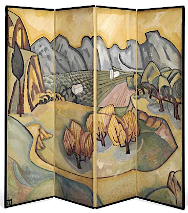
THE ALPILLES MASSIF PAINTED BY ROGER FRY

https://wanderingvertexes.blogspot.com/2020/11/the-alpilles-massif-painted-by-roger-fry.html


ROGER FRY (1866 -1934)
Les Alpilles  / Les  Opies  (496 m-1,627ft)
France (Provence) 


In Les Alpilles - Provençal screen,  1913, Private collection  


The mountains   

The Alpilles massif is located in the south of France, in the Bouches-du-Rhône department (Provence-Alpes-Côte d'Azur region), about sixty kilometers north of Marseille. It extends along an east-west axis for about 25 km, from the Rhône valley to the Durance valley. Several summit areas make it up: - The main part of the massif, called the Alpilles (“Little Alps”), stretches from the Saint-Gabriel chapel in Tarascon to the road linking Aureille to Eygalières.

- Les Opies  (496 m-1,627ft) east of the Alpille, is made up of three small peaks: the crêtes des Opies, Mont Menu and Défends (municipalities of Eyguières, Lamanon and Aureille).
- The  Rochers de la Pène) are a narrow link stretching to the south of the massif from which it is separated by the departmental road 17 (Arles-Paradou) .
- Les Costières, located in the town of Saint-Martin-de-Crau, is a plateau that marks the southern limit of the massif. This one gains altitude as one progresses towards the north, and slopes steeply on the marshes of Baux, to the south of the rocks of Pène.
- Les Chainons are a set of low altitude peaks (around 50 meters) between Aureille and Montmajour characterized by the sets of valleys they shelter. The Caisses de Jean-Jean are perhaps the best known of those hills

- The Mont Gaussier (306m -1,004 ft), located south of the city of Saint-Rémy-de-Provence. Today, the place of passage of many hikers who cross it by the GR6, Mount Gaussier was very early used as habitat by protohistoric populations, before having at its summit a medieval castle, nowadays disappeared. Mount Gaussier is made of crystalline limestone, white and hard. One finds in the soil the trace of many fossils. This type of summit is characteristic of the Alpilles range of mountains, especially on the north face.


The painter
Roger Eliot Fry was an English painter and critic, and a member of the Bloomsbury Group. Establishing his reputation as a scholar of the Old Masters, he became an advocate of more recent developments in French painting, to which he gave the name Post-Impressionism. He was the first figure to raise public awareness of modern art in Britain, and emphasised the formal properties of paintings over the "associated ideas" conjured in the viewer by their representational content. He was described by the art historian Kenneth Clark as "incomparably the greatest influence on taste since Ruskin ... In so far as taste can be changed by one man, it was changed by Roger Fry". The taste Fry influenced was primarily that of the Anglophone world, and his success lay largely in alerting an educated public to a compelling version of recent artistic developments of the Parisian avant-garde.
As a painter Fry was experimental (his work included a few abstracts), but his best pictures were straightforward naturalistic portraits, although he did not pretend to be a professional portrait - painter. In his art he explored his own sensations and gradually his own personal visions and attitudes asserted themselves. His work was considered to give pleasure, 'communicating the delight of unexpected beauty and which tempers the spectator's sense to a keener consciousness of its presence'. Fry did not consider himself a great artist, 'only a serious artist with some sensibility and taste'. 

___________________________

2020 - Wandering Vertexes...
by Francis Rousseau

Wednesday, November 11, 2020

THE FALAISES D'ETRETAT PAINTED BY GEORGES BRAQUE

https://wanderingvertexes.blogspot.com/2020/11/the-falaises-detretat-painted-by.html
 

GEORGES BRAQUE (1882-1963)
The Falaises d'Etretat (70 to 90 m - 230 to 300 ft)
France (Normandie)

 In Les Falaises d'Etretat, 1930, oil on canvas

The cliffs 
The Falaise d'Etretat (Etretat Chalk Complex), as it is known, consists of a complex stratigraphy of Turonian and Coniacian chalks. Some of the cliffs are as high as 90 metres (300 ft).  Etretat is best known for its chalk cliffs, including three natural arches and a pointed formation called L'Aiguille (the Needle), which rises 70 m- 230 ft above the sea.  L'arche et L'aiguille  (The Ark and the Needle) above.  An underground river, then marine erosion formed a natural arch and a estimated 55 meter to 70 meters  high needle, relic piece of the cliff. Maurice Leblanc describes it in these terms in his novel The Hollow Needle (1909) "An enormous roach, more than eighty meters high, colossal obelisk, plumb on its granite base"  At his time, the site already attracted many tourists among them "lupinophiles" admirers of Arsene Lupine: American students came for the key to the cave, where the "gentleman burglar" had found the treasure of kings of France. 


The Painter
Georges Braque (1882-1963) was a major 20th-century French painter, collagist, draughtsman, printmaker and sculptor. His most important contributions to the history of art were in his alliance with Fauvism from 1905, and the role he played in the development of Cubism. Braque's work between 1908 and 1912 is closely associated with that of his colleague Pablo Picasso. Their respective Cubist works were indistinguishable for many years, yet the quiet nature of Braque was partially eclipsed by the fame and  notoriety of Picasso. Braque believed that an artist experienced beauty "… in terms of volume, of line, of mass, of weight, and through that beauty [he] interpret[s] [his] subjective impression".   He described "objects shattered into fragments... [as] a way of getting closest to the object...Fragmentation helped me to establish space and movement in space”. He adopted a monochromatic and neutral color palette in the belief that such a palette would emphasize the subject matter.  Although Braque began his career painting landscapes, during 1908 he, alongside Picasso, discovered the advantages of painting still lifes instead. Braque explained that he “... began to concentrate on still lifes, because in the still-life you have a tactile, I might almost say a manual space... This answered to the hankering I have always had to touch things and not merely see them... In tactile space you measure the distance separating you from the object, whereas in visual space you measure the distance separating things from each other. This is what led me, long ago, from landscape to still-life”  A still life was also more accessible, in relation to perspective, than landscape, and permitted the artist to see the multiple perspectives of the object. Braque's early interest in still lifes revived during the 1930s.
During the period between the wars, Braque exhibited a freer, more relaxed style of Cubism, intensifying his color use and a looser rendering of objects. However, he still remained committed to the cubist method of simultaneous perspective and fragmentation. In contrast to Picasso, who continuously reinvented his style of painting, producing both representational and cubist images, and incorporating surrealist ideas into his work, Braque continued in the Cubist style, producing luminous, other-worldly still life and figure compositions. By the time of his death in 1963, he was regarded as one of the elder statesmen of the School of Paris, and of modern art.

Sunday, November 8, 2020

MONT VENTOUX PAINTED BY A. G. CARRICK / H.M KING CHARLES III


https://wanderingvertexes.blogspot.com/2020/11/mont-ventoux-painted-by-hrh-prince-of.html

A. G. CARRICK / H.M KING CHARLES III former PRINCE OF WALES (bn.1948)
Mont Ventoux (1,911 m - 6, 270 ft)
France (Provence)

In Mont Ventoux seen from Le Barroux, watercolor, 1999

The painter
Arthur George Carrick is actually H.M. the King Charles III, former Prince of Wales.
When he began showing his paintings, he was too nervous to display his name so displayed under a pseudonym. Arthur George are two of his names (Charles Phillip Arthur George) and one of his titles is Earl of Carrick. King Charles III is an experienced watercolourist.  He has been painting for most of his adult life, during holidays or when his official diary allows. King Charles' interest began during the 1970s and 1980s when he was inspired by Robert Waddell, who had been his art master at Gordonstoun in Scotland. In time, King Charles met leading artists such as Edward Seago, with whom he discussed watercolour technique, and received further tuition from John Ward, Bryan Organ and Derek Hill.
The Royal Family has a tradition of drawing and painting, and King Charles’ work first came to public notice at a 1977 exhibition at Windsor Castle at which other Royal artists included Queen Victoria, The Duke of Edinburgh and The Duke of York.
King Charles paints in the open air, often finishing a picture in one go and his favourite locations include The Queen's estate at Balmoral in Scotland and Sandringham House in Norfolk, England. Sometimes King Charles  III paints during his skiing holidays, and during overseas tours when possible.
The copyright of King Charles' watercolours belongs to A. G. Carrick Ltd, a trading arm of The King's Charities Foundation. Over the years King Charles III has agreed to exhibitions of his watercolours and of lithographs made from them, on the understanding that any income they generate goes to The Prince of Wales's Charitable Foundation.
Money from the sale of the lithographs also goes to the Foundation but the paintings themselves are never for sale.
In the 1980s King Charles III, then Prince of Wales,  began inviting young British artists to accompany him on official tours overseas and record their impressions, a tradition that has continued to this day.
Reference :
- The prince of Wales paintings 

The mountain
Mont Ventoux (Ventor in Latin) is located in the French department of Vaucluse (Provence-Alpes-Côte d'Azur). Culminating at 1,911 meters - 6, 270 ft, it is about 25 kilometers long on an east-west for 15 kilometers wide on a north-south axis. Nicknamed the Giant of Provence, it is the culmination of the Monts du Vaucluse, the ultimate link of the Southern Alps and the highest peak of Vaucluse. Its geographical isolation makes it visible over great distances.
Mont Ventoux is as well the linguistic border between the north and south-Occitan.
Its mainly calcareous nature is responsible, in its top part, its deep white color in every season and intense karstification due to erosion by water, with the presence of numerous scree on the south face. Precipitation is particularly abundant in spring and fall. Rainwater seeps into galleries and reflects the level of the variable flow resurgences such as Fontaine de Vaucluse or Source du Groseau.
Mont Ventoux is subject to a Mediterranean dominant weather, sometimes causing scorching temperatures during summer, the altitude offering a wide variety of climates, to the top (continental influence of mountain type), through a temperate climate (mid-slopes). In addition, the north wind can be very violent and the Mistral blows almost half part of the year.
This particular geomorphology and climate make it a rich and fragile environmental site consisting of many levels of vegetation. It is s a biosphere reserve by UNESCO and Natura 2000 site.
If human settlements are found in the foothills in prehistoric times, the first ascent to the summit would work on 26 April 1336, the poet Petrarch from Malaucène on the northern slope. It opens the way later in numerous scientific studies.
Thereafter, for nearly six centuries, Mont Ventoux has been intensely deforested to provide the shipbuilding in Toulon, charcoal manufacturers and sheep farmers. During World War II, the mountain is home to the Ventoux maquis, the french Resistance against Nazis.
Since 1966, the summit is topped with an observation tower over forty meters high topped by a TV and satellite antenna.
While sheep farming has almost disappeared, beekeeping, gardening (especially cherries), viticulture, harvesting of mushrooms including truffles and, to a lesser extent, lavender, are still practiced.
Mont Ventoux is an important symbolic figure of Provence that fed oral or literary works and artistic performances or pictorial map.

_______________________________
2020 - Wandering Vertexes...
by Francis Rousseau

Wednesday, November 4, 2020

MOUNT ELBRUS/ EASTERN SUMMIT PAINTED BY ILYA NIKOLAEVICH ZANKOVSKY

https://wanderingvertexes.blogspot.com/2020/11/ilya-nikolaevich-zankovsky-1832-1919.html

ILYA NIKOLAEVICH ZANKOVSKY  (1832-1919)
Mount Elbrus / eastern summit (5,621 m-18,442 ft)
Russia

In  Frosty morning in Caucasus, oil on canvas, 1832, Private collection


The mountain 

Mount Elbrus (5,642 m -18,510 ft)should not be confused with the Alborz (also called Elburz) mountains in Iran, which also derive their name from the legendary mountain Harā Bərəzaitī in Persian mythology. A dormant volcano, Elbrus forms part of the Caucasus Mountains in Southern Russia, near the border with Georgia. Elbrus has two summits, both of which are dormant volcanic domes. With its slightly taller west summit, the mountain stands at 5,642 metres ; the east summit (see painting above) is 5,621 metres (18,442 ft). The lower east summit was first ascended on 10 July 1829 by Khillar Khachirov, a Karachayguide for an Imperial Russian army scientific expedition led by General Emmanuel, and the higher in 1874 by an British expedition led by F. Crauford Grove and including Frederick Gardner, Horace Walker, and the Swiss guide Peter Knubel of St. Niklaus in the canton Valais. While there are differing authorities on how the Caucasus are distributed between Europe and Asia, most relevant modern authorities define the continental boundary as the Caucasus watershed, placing Elbrus in Europe due to its position on the north side in Russia. Mount Elbrus was formed more than 2.5 million years ago. The volcano is currently considered inactive. Elbrus was active in the Holocene, and according to the Global Volcanism Program, the last eruption took place about AD 50. Mount Elbrus also called Karachay-Balkar is the highest mountain in Europe, and the seven highest summit in the world. The seven summit (which are obviously 8, with 2 in Europe !) are : Mount Everest (8,848m), Aconcagua (6,961m), Mt Denali or Mc Kinley (6,194m), Kilimandjaro (5,895m), Mt Elbrus (5,642m), Vinson Massif (4,892m), Mt Blanc (4,807m) and Mount Kosciuszko (2,228m) in Australia.

The painter
Ilya Zankovsky was a russian painter and graphic artist who studied as a noncredit student in the Imperial Academy of Arts (IAKh, 1862–1863) and who did not finish the course. Zankovsky lived in Tiflis, served in the Military topographic department of the Caucasus military region. He painted landscapes of the Caucasus (Mount Elbrus (above), Georgian military road, The Darial Gorge, From the main mountain range, Mount Ushba. Hunters halt). He worked a lot in watercolor. His works were shown at the exhibitions of the Caucasian Society for Encouragement of Fine Arts, the Society for mutual aid of Caucasian artists, the Society of Russian Watercolorists, and at the Autumn exhibitions in the halls of the IAKh. Zankovsky taught in the Drawing School under the Caucasian Society for Encouragement of Fine Arts in 1880s–1910s.
In 2009 an exhibition of Zankovsky’s works was held in Moscow. Works by Ilya Zankovsky are in many museum collections, including the State Russian Museum, Odessa Fine Arts Museum, Omsk Regional Museum of Fine Arts named after M. A. Vrubel, and Dagestan Museum of Local History.

_______________________________

2020 - Wandering Vertexes...
by Francis Rousseau


Sunday, November 1, 2020

MOUNT GERIZIM BY FÉLIX BONFILS


FÉLIX BONFILS (1831-1885) Mount Gerizim (881m - 2,890 ft) Palestine  In Mount Gerizim from Mount Ebal - Maison Bonfils, Oregon State University

FÉLIX BONFILS (1831-1885)
Mount Gerizim (881m - 2,890 ft)
Palestine

In Mount Gerizim from Mount Ebal - Maison Bonfils, Oregon State University

The mountain
Mount Gerizim or Garizim or Ar-garízim in Hebrew, Jabal Jarizīm in Arabic is a West Bank mountain near Nablus, in the historic region of Samaria. This mountain is a holy place for the Samaritans, who can argue that it is mentioned several times in the Torah. The height of Mount Gerizim is 881 meters, very steep on its northern flank and covered with brush at the top. It is one of the highest mountains in the West Bank and Israel. At his feet springs a spring of fresh water.
Around -330 BC. AD, the Samaritan population built a temple at the top of the mountain that became the religious center of Samaritanism, like the Temple of Jerusalem for Judaism. This temple will be built a little before1 the conquest of Alexander the Great, or just after. The temple is then surrounded by fortifications (according to the Book of the Maccabees). However, it will be destroyed by King Hasmonean John Hyrcan I in the 2nd century BC (circa -108 BC) According to archaeological excavations and ancient sources, a temple dedicated to Zeus is built on the site. during the time of Emperor Hadrian. From its conversion to Christianity, the Byzantine Empire attempted to forcibly convert minorities (heterodox Christians or non-Christians) to its version of Christianity. Thus, the Emperor Zeno (born in 427 - reign from 474 to his death in 491) attacks the Jews and the Samaritans. During his reign, the Samaritan temple is destroyed a second time (in 484, it seems), and this, in a definitive way. It will never be rebuilt.
When Christianity became the dominant religion in the Roman Empire, the Samaritans were denied access to Mount Gerizim. A church, protected by ramparts, was built at the top. This was one of the causes of the Samaritan revolt under the leadership of Julianus ben Sabar in the sixth century, a revolt whose repression will be so terrible that the Samaritans, then very numerous in the north of Palestine, became a small residual population. Despite the destruction of the temple, the mountain has remained the religious center of the Samaritans until today. This is how the Samaritan high priest is to reside around Mount Gerizim. This one is chosen within the priestly family (or "house") which is "supposed to descend from the son of Aaron, brother of Moses".


The photographer
Félix Bonfils wasborn in Saint-Hippolyte-du-Fort (France). He moved to Beirut in 1867 where he opened with his wife and his son Adrien, the photographic workshop Maison Bonfils, he renamed in 1878 F. Bonfils and Co..
Bonfils photographed in Lebanon, Egypt, Palestine, Syria and Greece as well as in Constantinople from 1876.
He was very active as soon as he arrives in Lebanon: his catalog mentions more than 15,000 prints in the early 1870s, made from nearly 200 negatives, and 9,000 stereoscopic views.
His works became famous thanks to tourists from the Middle East who brought his photographs as souvenirs. His views could be purchased individually, but they were also available as albums.
However, these photographs, produced by the workshop, could sometimes be the work of his son Adrien or assistants of the company.
In 1876 he returned to Alès (France), where he opened another studio around 1881. The one of Beirut was not closed. His wife Marie-Lydie and his son kept it opened and active after this death in 1885. This establishment was still very active in 1905, when a fire destroyed it.
The Bonfils business continued for several decades after the death of its founder. It was bought in 1918 by Abraham Guiragossian, a partner since 1909, who kept its name. It is mentioned in the Blue Guide in 1932.

___________________________________
2020 - Wandering Vertexes
A blog by Francis Rousseau

Thursday, October 29, 2020

INDRASAN PAINTED BY VASILY VERESHCHAGIN


VASILY VERESHCHAGIN (1842-1904)
Mount Idrasan (6,621m - 21, 722ft)
India, Pakistan

In Glacier on the Road from Kashmir to Ladakh, 1875,  Tretyakov Gallery Moscow.

The mountain
Mount Indrasan (6,621m - 21, 722ft) is located in Kullu district, Himachal Pradesh. Mt. Indrasan is considered as the most difficult mountain to climb in the Pir Panjal range of the Himalayas because of the challenges involved in scaling it. It was first climbed on October 13, 1962 by an expedition organized by Kyoto University Alpine Club, Kyoto, Japan. It is also believed that whenever Lord Indra arrives on earth he resides here. Indrasan i.e. the royal seat of the Lord Indra. The Pir Panjal Range also Panchaladeva in Hindu scriptures, is a group of mountains in the Lesser Himalayan region, running from east-southeast (ESE) to west-northwest (WNW) across the Indian state of Himachal Pradesh, the Indian administrated Union Territory of Jammu and Kashmir and the Pakistani administered territory of Azad Kashmir, where the average elevation varies from 1,400 m (4,600 ft) to 4,100 m (13,500 ft). The Himalayas show a gradual elevation towards the Dhauladhar and Pir Panjal ranges. Pir Panjal is the largest range of the Lesser Himalayas. The region is connected to the Valley of Kashmir via Mughal Road and used to be the historical connection of Kashmir with India.

 
The painter
Vasily Vasilyevich Vereshchagin (Васи́лий Васи́льевич Вереща́гин) transcribed in English as "Basil Verestchagin", was one of the most famous Russian war artists and one of the first Russian artists to be widely recognized abroad. The graphic nature of his realist scenes led many of them to never be printed or exhibited. In 1864 he proceeded to Paris, where he studied under Jean-Léon Gérôme, though he dissented widely from his master's methods. In the Paris Salon of 1866 he exhibited a drawing of Dukhobors chanting their Psalms. In the next year he was invited to accompany General Konstantin Kaufman's expedition to Turkestan. He was an indefatigable traveler, returning to St. Petersburg in late 1868, to Paris in 1869, back to St. Petersburg later in the year, and then back to Turkestan at the end 1869 via Siberia. In 1871, he established an atelier in Munich, and made a solo exhibition of his works at the Crystal Palace in London in 1873.
More about the painter

____________________________________

Wandering Vertexes 2020
A blog by Francis Rousseau

Sunday, October 25, 2020

MUIR GLACIER PAINTED BY THOMAS HILL

THOMAS HILL (1829-1908) Muir Glacier (90 m - 200 ft) United States of America ( Alaska)


THOMAS HILL (1829-1908)
Muir Glacier (90 m - 200 ft)
United States of America ( Alaska)

In Muir Glacier, Alaska. oil on canvas, Oakland Museum of California

The Glacier
Muir Glacier is a glacier in Glacier Bay National Park and Preserve in the U.S. state of Alaska. It is currently about 0.7 km (0.43 mi) wide at the terminus. As recently as the mid-1980s the glacier was a tidewater glacier and calved icebergs from a wall of ice 90 m (200 feet) tall.
The glacier is named after Scottish-born naturalist John Muir, who traveled around the area and wrote about it, generating interest in the local environment and in its preservation. His first two visits were in 1879 (at age 41) and 1880. During the visits, he sent an account of his visits in installments to the San Francisco Bulletin. Later, he collected and edited these installments in a book, Travels in Alaska, published in 1915, the year after he died.
Muir Glacier has undergone very rapid, well-documented retreat since its Little Ice Age maximum position at the mouth of Glacier Bay around 1780. In 1794, the explorer Captain George Vancouver found that most of Glacier Bay was covered by an enormous ice sheet, some 1,200 meters (3,900 ft) in places.
In 1904 the glacier reportedly "broke through the mountains" with Pyramid Peak to the west and Mt. Wright and Mount Case to the east.
From 1892 to approximately 1980, it had retreated nearly 32 kilometers (20 mi). Between 1941 and 2004, the glacier retreated more than 12 kilometers (7.5 mi) and thinned by over 800 meters (2,600 ft). Ocean water has filled the valley replacing the ice and creating Muir Inlet.


The painter
Thomas Hill was an American artist of the 19th century. He produced many fine paintings of the California landscape, in particular of the Yosemite Valley, as well as the White Mountains of New Hampshire. Hill’s work was often driven by a vision resulting from his experiences with nature. For Thomas Hill, Yosemite Valley and the White Mountains of New Hampshire were his sources of inspiration to begin painting and captured his direct response to nature.
Hill was loosely associated with the Hudson River School of painters. The Hudson River School celebrated nature with a sense of awe for its natural resources, which brought them a feeling of enthusiasm when thinking of the potential it held. Mainly the earlier members of the Hudson River School, around the 1850-60’s, displayed man as in unison with nature in their landscape paintings by often painting men on a very small scale compared to the vast landscape. Thomas Hill often brought this technique into his own paintings in for example in his painting, Yosemite Valley, 1889.
He made early trips to the White Mountains with his friend Benjamin Champney and painted White Mountain subjects throughout his career. An example of his White Mountain subjects is Mount Lafayette in his Mount Lafayette in Winter.
Hill acquired the technique of painting en plein air. These paintings in the field later served as the basis for larger finished works. In plein air means to “paint outdoors and directly from the landscape”,[ which Hill incorporated into many of his paintings. Hill’s landscape paintings demonstrate how he combined his powers of observation with powerful motifs in each painting.
Hill’s move to California in 1861 brought him new material for his paintings. He chose monumental vistas, like Yosemite. During his lifetime, Hill’s paintings were popular in California, costing as much as $10,000. Hill's best works are considered to be these monumental subjects, including Great Canyon of the Sierra, Yosemite, Vernal Falls and Yosemite Valley.

___________________________________________

2020 - Wandering Vertexes...
by Francis Rousseau

Wednesday, October 21, 2020

POPOCATEPETL PAINTED BY JOSÉ MARIRA VELASCO


JOSÉ MARIA VELASCO (1840-1912) The Popocatépetl (5,426 m -17,802 ft) Mexico  In Popocatepetl and Iztacchihuatl , oil on canvas, Private owner

JOSÉ MARIA VELASCO (1840-1912)
The Popocatépetl (5,426 m -17,802 ft)
Mexico

In Popocatepetl , oil on canvas, Private owner

The mountain
Popocatépetl (5,426 m - 17,802 ft) is an active volcano, located in the states of Puebla, Mexico, and Morelos, in Central Mexico, and lies in the eastern half of the Trans-Mexican volcanic belt. The name Popocatépetl comes from the Nahuatl words popōca (it smokes) and tepētl (mountain), meaning Smoking Mountain. It is the second highest peak in Mexico, after Citlaltépetl (Pico de Orizaba) at 5,636 m (18,491 ft).
It is linked to the Iztaccihuatl volcano to the north by the high saddle known as the Paso de Cortés.
Popocatépetl is 70 km (43 mi) southeast of Mexico City, from where it can be seen regularly, depending on atmospheric conditions. Until recently, the volcano was one of three tall peaks in Mexico to contain glaciers, the others being Iztaccihuatl and Pico de Orizaba. In the 1990s, the glaciers such as Glaciar Norte (North Glacier) greatly decreased in size, partly due to warmer temperatures but largely due to increased volcanic activity. By early 2001, Popocatépetl's glaciers were gone; ice remained on the volcano, but no longer displayed the characteristic features of glaciers such as crevasses.
Magma erupting from Popocatépetl has historically been predominantly andesitic, but it has also erupted large volumes of dacite. Magma produced in the current cycle of activity tends to be a mixture of the two.

The Painter
José Maria Tranquilino Francisco de Jesus Velasco Gomez Obregуn, generally known as José Marнa Velasco, was a 19th-century Mexican polymath, most famous as a painter who made Mexican geography a symbol of national identity through his paintings.
Velasco's long career elevated Mexican landscape painting to international standing. One of his landscapes of the Valley of Mexico is in the Vatican Museum, a gift to Pope Leo XIII. His scenes of the Mexican landscape are a visual source for environmental historians, since they show the Valley of Mexico before its degradation in the twentieth century, with air pollution and urban sprawl. His landscape art has a wide appeal, since it is more accessible than history paintings that require the viewer to understand a particular event.
Today the Government of the State of Mexico, where Velasco was from, presents an award for artistic merit in his name to painters born in that state. Among the most outstanding winners are Luis Nishizawa, Leopoldo Flores, Ignacio Barrios and Héctor Cruz.
The José María Velasco Museum was opened in 1992 in Toluca City with the task of preserving and promoting his paintings

_______________________________
2020 - Wandering Vertexes...
by Francis Rousseau

Saturday, October 17, 2020

THE WATZMANN PAINTED BY JOHAN CHRISTIAN DAHL

https://wanderingvertexes.blogspot.com/2020/10/johan-christian-dahl-1788-1857-watzmann.html


JOHAN CHRISTIAN DAHL  (1788-1857)
The Watzmann (2,713m - 8,901ft)
Germany (Bavarian Alps)

In The Watzmann (1825), Oil on canvas, 45 x 33 cm, Nasjonalgalleriet, Oslo

The mountain
The Watzmann (2,713m - 8,901ft) is a mountain in the Bavarian Alps south of the village of Berchtesgaden. It is the third highest in Germany, and the highest located entirely on German territory. Three main peaks array on a N-S axis along a ridge on the mountain's taller western half: Hocheck (2,651 m), Mittelspitze (Middle Peak, 2,713 m) and Sьdspitze (South Peak, 2,712 m).
The Watzmann massif also includes the 2,307 m Watzmannfrau (Watzmann Wife, also known as Kleiner Watzmann or Small Watzmann), and the Watzmannkinder (Watzmann Children), five lower peaks in the recess between the main peaks and the Watzmannfrau.
The entire massif lies inside Berchtesgaden National Park.
The Watzmann Glacier is located below the famous east face of the Watzmann in the Watzmann cirque and is surrounded by the Watzmanngrat arête, the Watzmannkindern and the Kleiner Watzmann. The size of the glacier reduced from around 30 hectares (74 acres) in 1820 until it split into a few fields of firn, but between 1965 and 1980 it advanced significantly again and now has an area of 10.1 hectares (25 acres). Above and to the west of the icefield lie the remains of a transport-bomber that crashed in October 1940.
Amongst the other permanent snow and icefields the Eiskapelle ("Ice Chapel") is the best known due to its easy accessibility from St. Bartholomä. The Eiskapelle may well be the lowest lying permanent snowfield in the Alps. Its lower end is only 930 metres high in the upper Eisbach valley and is about an hour's walk from St. Bartholomä on the Königssee. The Eiskapelle is fed by mighty avalanches that slide down from the east face of the Watzmann in spring and accumulate in the angle of the rock face. Sometimes a gate-shaped vault forms in the ice at the point where the Eisbach emerges from the Eiskapelle. Before entering there is an urgent warning sign that others have been killed by falling ice.
In the east face itself is another icefield in the so-called Schöllhorn cirque, called the Schöllhorneis, which is crossed by the Kederbach Way (Kederbacher-Weg). The cirque and icefield are named after the Munich citizen, Christian Schöllhorn, who was the first victim on the east face. On 26 May 1890 he fell at the upper end of the icefield into the randkluft and was fatally injured. Another small nameless snowfield is located several hundred metres below the Mittelspitze also in the east face. 


CADILLAC MOUNTAIN BY SANFORD ROBINSON GIFFORD


SANFORD ROBINSON GIFFORD (1823-1880) Cadillac Mountain (466 m - 1,530 ft) United States of America (Maine)  In The Artist Sketching at Mount Desert, Maine, oil on canvas 1860s,  National Gallery of art, Washington DC

SANFORD ROBINSON GIFFORD (1823-1880)
Cadillac Mountain (466 m - 1,530 ft)
United States of America (Maine)

In The Artist Sketching at Mount Desert, Maine, oil on canvas 1860s, 
National Gallery of art, Washington DC 

The mountain,
Cadillac Mountain (466 m-1,530 ft) is located on Mount Desert Island, within Acadia National Park, in the U.S. state of Maine. Its summit is the highest point in Hancock County and the highest within 25 miles (40 km) of the shoreline of the North American continent between the Cape Breton Highlands, Nova Scotia and peaks in Mexico. It is known as the first place in the U.S. to see the sunrise, although that is only true for a portion of the year. Before being renamed in 1918, the mountain had been called Green Mountain. The new name honors the French explorer and adventurer Antoine Laumet de La Mothe, sieur de Cadillac. In 1688, De la Mothe requested and received from the Governor of New France a parcel of land in an area known as Donaquec which included part of the Donaquec River (now the Union River) and the island of Mount Desert in the present-day U.S. state of Maine. Antoine Laumet de La Mothe, a shameless self-promoter who had already appropriated the "de la Mothe" portion of his name from a local nobleman in his native Picardy, thereafter referred to himself as Antoine de la Mothe, sieur de Cadillac, Donaquec, and Mount Desert ! From 1883 until 1893 the Green Mountain Cog Railway ran to the summit to take visitors to the Green Mountain Hotel. The hotel burned down in 1895 and the cog train was sold and moved to the Mount Washington Cog Railway in New Hampshire
 
The painter 

Sanford Robinson Gifford was born in Greenfield, New York and spent his childhood in Hudson, New York, the son of an iron foundry owner. He attended Brown University 1842-44, before leaving to study art in New York City in 1845. He studied drawing, perspective and anatomy under the direction of the British watercolorist and drawing-master, John Rubens Smith.  He also studied the human figure in anatomy classes at the Crosby Street Medical college and took drawing classes at the National Academy of Design.  By 1847 he was sufficiently skilled at painting to exhibit his first landscape at the National Academy and was elected an associate in 1851, an academician in 1854. Thereafter Gifford devoted himself to landscape painting, becoming one of the finest artists of the early Hudson River School.
Like most Hudson River School artists, Gifford traveled extensively to find scenic landscapes to sketch and paint. In addition to exploring New England, upstate New York and New Jersey, Gifford made extensive trips abroad. He first traveled to Europe from 1855 to 1857, to study European art and sketch subjects for future paintings. During this trip Gifford also met Albert Bierstadt and Worthington Whittredge.
In 1858, he traveled to Vermont, "apparently" with his friend and fellow painter Jerome Thompson. Details of their visit were carried in the contemporary Home Journal. Both artists submitted paintings of Mount Mansfield, Vermont's tallest peak, to the National Academy of Design's annual show in 1859. Thompson's work, "Belated Party on Mansfield Mountain" is now owned by the MET in New York, according to the report.
Thereafter, he served in the Union Army as a corporal in the 7th Regiment of the New York Militia upon the outbreak of the Civil War. A few of his canvases belonging to New York City's Seventh Regiment and the Union League Club of New York are testament to that troubled time.
During the summer of 1867, Gifford spent most of his time painting on the New Jersey coast, specifically at Sandy Hook and Long Branch, according to an auction Web site.
Another journey, this time with Jervis McEntee and his wife, took him across Europe in 1868. Leaving the McEntees behind, Gifford traveled to the Middle East, including Egypt in 1869. Then in the summer of 1870 Gifford ventured to the Rocky Mountains in the western United States, this time with Worthington Whittredge and John Frederick Kensett. At least part of the 1870 travels were as part of a Hayden Expedition, led by Ferdinand Vandeveer Hayden.
Returning to his studio in New York City, Gifford painted numerous major landscapes from scenes he recorded on his travels. Gifford's method of creating a work of art was similar to other Hudson River School artists. He would first sketch rough, small works in oil paint from his sketchbook pencil drawings. Those scenes he most favored he then developed into small, finished paintings, then into larger, finished paintings.
Gifford referred to the best of his landscapes as his "chief pictures". Many of his chief pictures are characterized by a hazy atmosphere with soft, suffuse sunlight. Gifford often painted a large body of water in the foreground or middle distance (see above) in which the distant landscape would be gently reflected. Examples of Gifford's "chief pictures" in museum collections today include: Lake Nemi (1856–57), Toledo Museum of Art, Toledo, Ohio ; The Wilderness (1861), Toledo Museum of Art, Toledo, Ohio ;  A Passing Storm (1866), Wadsworth Atheneum, Hartford, Connecticut ;  Ruins of the Parthenon (1880), Corcoran Gallery of Art, Washington, D.C.
On August 29, 1880, Gifford died in New York City, having been diagnosed with malarial fever. The MET in New York City celebrated his life that autumn with a memorial exhibition of 160 paintings. A catalog of his work published shortly after his death recorded in excess of 700 paintings during his career.


_______________________________
2020 - Wandering Vertexes...
by Francis Rousseau


Wednesday, October 14, 2020

TETON RANGE PAINTED BY THOMAS MORAN

THOMAS MORAN (1837-1926) Grand Teton (4,199 m - 13,775 ft) United States of America (Wyoming)  In Teton range, Oil on cnavas, 1897, 76.2 x 114.3 cm, The MET, (on view on Gallery 765)

THOMAS MORAN (1837-1926)
Grand Teton (4,199 m - 13,775 ft)
United States of America (Wyoming)

In Teton range, Oil on cnavas, 1897, 76.2 x 114.3 cm, The MET, (on view on Gallery 765)

 About this painting in the MET note
" As Albert Bierstadt claimed the Rocky Mountains and the Sierra Nevada for his art, so Moran made the Yellowstone region and the Grand Canyon his signature subjects. His dazzling watercolors of Yellowstone led directly to its designation, in 1872, as the first national park. A native of Great Britain and an ardent admirer of the English painter J. M. W. Turner, Moran used prismatic color to capture the splendors of the American West—such as this dramatic view of the Tetons, located just south of Yellowstone. For centuries, Indigenous communities lived on and cared for this land, yet they are notably absent from Moran’s work. Instead, the artist depicted the landscape as an untouched pre-industrial paradise—thus, ripe for White settlement and colonization "


The mountain
Grand Teton (4,199 m - 13,775 ft) is the highest mountain in Grand Teton National Park in Northwest Wyoming, and a classic destination in American mountaineering. It is the highest point of the Teton Range, and the second highest peak in the U.S. state of Wyoming after Gannett Peak. The mountain is entirely within the Snake River drainage basin, which it feeds by several local creeks and glaciers.The Teton Range is a subrange of the Rocky Mountains, which extend from southern Alaska to northern New Mexico.  Grand Teton's name was first recorded as Mount Hayden by the Washburn-Langford-Doane Expedition of 1870. However, the name "the Grand Teton" had early currency. The Edition of April, 1901 of the USGS 1:125,000 quadrangle map of the area shows "Grand Teton" as the name of the peak. A United States National Park named "Grand Teton National Park" was established by law in 1929. By 1931, the name Grand Teton Peak was in such common usage that it was recognized by the USGS Board on Geographic Names. Another shift in usage led the Board to shorten the name on maps to Grand Teton in 1970. The origin of the name is disputed. The most common explanation is that "Grand Teton" means "large teat" in French, named by either French-Canadian or Iroquois members of an expedition led by Donald McKenzie of the North West Company. However, other historians disagree, and claim that the mountain was named after the Teton Sioux tribe of Native Americans.

The painter

Thomas Moran was an American painter and printmaker of the Hudson River School in New York whose work often featured the Rocky Mountains. Moran and his family took residence in New York where he obtained work as an artist. He was a younger brother of the noted marine artist Edward Moran, with whom he shared a studio. A talented illustrator and exquisite colorist, Thomas Moran was hired as an illustrator at Scribner's Monthly. During the late 1860s, he was appointed the chief illustrator for the magazine, a position that helped him launch his career as one of the premier painters of the American landscape, in particular, the American West.
Moran along with Albert Bierstadt, Thomas Hill, and William Keith are sometimes referred to as belonging to the Rocky Mountain School of landscape painters because of all of the Western landscapes made by this group.
Thomas Moran has a painting exhibited as part of the White House collection with The Three Tetons painted in 1895.

_____________________________

2020 - Wandering Vertexes...
by Francis Rousseau

Saturday, October 10, 2020

MOUNT HAWKES / HAWKES HEIGHTS BY CHARLES HAMILTON SMITH


CHARLES HAMILTON SMITH (1776-1859), Mount Hawkes / Hawkes Heights ( 2,000 m- 6,600 ft) Antarctic (Coulman Island)  In Coulman Island, discovered Jan.4. 1844, watercolor on paper,Yale Center for BRitish Art, New Haven, USA

CHARLES HAMILTON SMITH (1776-1859),
Mount Hawkes / Hawkes Heights (2,000 m- 6,600 ft)
Antarctic (Coulman Island)

In Coulman Island, discovered Jan.4. 1844, watercolor on paper,
Yale Center for BRitish Art, New Haven, USA


The mountain
Mount Hawkes ( 2,000 m- 6,600 ft) also called  Hawkes Heights  is an ice-filled volcanic crater that dominates the southern part of Coulman Island, in the Ross Sea, Antarctica and marks the island's summit. The feature was named by the New Zealand Geological Survey Antarctic Expedition (NZGSAE), 1958–59, for Captain William M. Hawkes, U.S. Navy, who took a leading part in early air operations from Williams Field near McMurdo Station, including long range photo reconnaissance and supply flights, and the first air landing at the South Pole. He was commander of one of the two planes which made the historic first flight from Christchurch to McMurdo Station on December 17, 1955. His air photos proved of great value to two NZGSAE parties to this part of Victoria Land. Mount Hawkes is also named for Hawkes, who was assigned to Air Development Squadron Six (VX-6) in 1955–56.


The artist
Lieutenant-Colonel Charles Hamilton Smith, was an English artist, naturalist, antiquary, illustrator, soldier, and... spy as well !. His military career began in 1787, when he studied at the Austrian academy for artillery and engineers at Mechelen and Leuven in Belgium (his native country). Although his military service, which ended in 1820 and included the Napoleonic Wars, saw him travel extensively (including the West Indies, Canada, United States, Southern and Northern Europe and ...Antarctica).
As a prolific self-taught illustrator (over 38,000 drawings!) He left quite an important number of books of beautifully watercolored landscapes taken all around the world. those nooks of watercolors are nowadays in the collections of the Yale Center From British Art. Among them :
- Views of France, Volume I (81 watercolors), Views of France, Volume II (93 watercolors),
- Views of England and Wales, Volume I (82 watercolors), Views of England and Wales, Volume II (74 watercolors),
- Views of Northern Europe, Volume I (68watercolors) , Views of Northern Europe, Volume II (78) watercolors),
- Views of Polar Regions (75 watercolors) (see above)
- Views of Spain, Volume I (69 watercolors), Views of Spain, Volume II (72 watercolors), But one of his noteworthy achievements was an 1800 experiment to determine which color should be used for military uniforms. He is also known in military history circles for Costume of the Army of the British Empire, produced towards the end of the Napoleonic Wars and an accurate depiction of contemporary British uniform.
As an antiquarian, he also produced, in collaboration with Samuel Rush Meyrick, Costume of the Original Inhabitants of the British Islands, 1815, and The Ancient Costume of England, with historical illustrations of medieval knights, ladies, shipsm and battles.
He also wrote on the history of the Seven Years' War and The Natural history of dogs.
Quite a productive fellow !

___________________________________________

2020 - Wandering Vertexes...
by Francis Rousseau