google.com, pub-0288379932320714, DIRECT, f08c47fec0942fa0 GRAVIR LES MONTAGNES... EN PEINTURE

Monday, November 19, 2018

VOLCÁN DE AGUA / HUNAHPÚ BY ALFRED MAUDSLAY


 ALFRED MAUDSLAY (1850-1931)
Volcán de Agua / Hunahpú  (3,760 m- 12, 349 ft)
Guatemala

 In   Volcano de Agua  from Santa Maria from the book A glimpse of Guatemala,  
John Murray, ed. London, 1889 

The volcano 
Volcán de Agua (3, 760m - 12, 349 ft)  (also known by Maya as Hunahpú meaning Place of flowers) is a stratovolcano located in the departments of Sacatepéquez and Escuintla in Guatemala.  
The Spanish conquistadors also called it Hunapú until a lahar from the volcano on September 10, 1541 destroyed the original capital of Guatemala (now known as Ciudad Vieja) and the city was moved to the current site of Antigua Guatemala following this disaster.
Agua Volcano dominates the local landscape except when hidden by cloud cover. The volcano is within 5 to 10 km (3.1 to 6.2 mi) of the city of Antigua Guatemala and several other large towns situated on its northern apron. These towns have a combined population of nearly 100,000. It is within about 20 km of Escuintla (population, ca .100,000) to the south. Coffee is grown on the volcano's lower slopes.
In 1895 Anne Cary Maudslay and her husband, archeologist Alfred Percival Maudslay visited the Antigua Guatemala region as part of a journey through Guatemala's Maya and colonial archeological monuments, and climbed the Volcán de Agua (photo above)  ; she wrote a book called A Glimpse at Guatemala where she explains that water from the volcano crater could not have destroyed the old Santiago. 
The Volcán de Agua has been declared a protected area in 1956 and covers an area of 12,600 Ha.

The photographer 
The  British diplomat, explorer and archaeologist Alfred Percival Maudslay  was also a photographer... and rather a good one according to the numerous photographs on dry plate he left.   He was one of the first Europeans to study Maya ruins.
After leaving Medical School, he moved to Trinidad, becoming private secretary to Governor William Cairns, and transferred with Cairns to Queensland. He subsequently moved to Fiji to work with Sir Arthur Gordon, its governor.  Later he served as British consul in Tonga and Samoa. In February 1880, Maudslay resigned from the colonial service to pursue his own interests, having spent six years in the British Pacific colonies. He then joined his siblings in Calcutta during their round-the-world trip, returned to Britain in December, and then set out for Guatemala via British Honduras.
In Guatemala, Maudslay began the major archaeological work for which he is now best remembered. He started at the Maya ruins of Quirigua and Copan where, with the help of Frank Sarg, he hired labourers to help clear and survey the remaining structures and artefacts. Sarg also introduced Maudslay to the newly found ruins in Tikal and to a reliable guide Gorgonio López. Maudslay was the first to describe the site of Yaxchilán. With Teobert Maler, Alfred Maudslay explored Chichén in the 1880s and both spent several weeks at the site and took extensive photographs. Maudslay published the first long-form description of Chichen Itza in his book, "Biologia Centrali-Americana".
In the course of his surveys, Maudslay pioneered many of the later archaeological techniques. He hired Italian expert Lorenzo Giuntini and technicians to make plaster casts of the carvings, while Gorgonio López made casts of papier-mâché. Artist Annie Hunter drew impressions of the casts before they were shipped to museums in England and the United States. Maudslay also took numerous detailed photographs – dry plate photography was then a new technique – and made copies of the inscriptions.
All told, Maudslay made a total of six expeditions to Maya ruins. After 13 years of preparation, he published his findings in 1902 as a 5-volume compendium entitled Biologia Centrali-Americana, which contained numerous excellent drawings and photographs of Maya ruins, Maudslay's commentary, and an appendix on archaic calendars by Joseph Thompson Goodman.
In 1907 the Maudslays moved permanently back to Britain. Maudslay become a President of the Royal Anthropological Institute 1911–12. He also chaired the 18th International Congress of Americanists in London in 1912.

_______________________________
 
2018 - Wandering Vertexes...
by Francis Rousseau 


Sunday, November 18, 2018

CERRO RORAIMA BY CHARLES BENTLEY


CHARLES BENTLEY (1805-1854) 
 Cerro Roraima (2,810 m - 9,220 ft)
Brazil, Venezuela, Guyana border 

In Roraima (on right)  from  Views in the Interior of Guiana, Tepuy Roraima, lithograph, 1870,  British Library 

The mountain 
 Cerro Roraima (2,810m- 9,220ft) or  Tepuy Roraima  is the highest of the Pakaraima chain of Tepui plateaus in South America. First described by the English explorer Sir Walter Raleigh during his 1595 expedition, its 31-square-kilometre (12-square-mile) summit area is bounded on all sides by cliffs rising 400 metres (1,300 ft). The mountain also serves as the tripoint of Venezuela, Guyana and Brazil. Mount Roraima lies on the Guiana Shield in the southeastern corner of Venezuela's 30,000-square-kilometre (12,000-square-mile) Canaima National Park forming the highest peak of Guyana's Highland Range.
The highest point in Guyana and the highest point of the Brazilian state of Roraima lie on the plateau, but Venezuela and Brazil have higher mountains elsewhere. The triple border point is at 5°12′08″N 60°44′07″W,[6] but the mountain's highest point is Maverick Rock or Maverick Stone, at the southern end of the plateau and wholly within Venezuela.

The artist
Charles Bentley was an English watercolour painter of coastal and river scenery. Bentley was born in 1805 or 1806, the son of a master-carpenter and builder living in Tottenham Court Road, London. He was sent to work colouring prints for Theodore Fielding to whom he was eventually apprenticed in order to learn aquatinting. During his apprenticeship he was sent to Paris, probably to assist work on the plates for Excursion sur les Cotes et dans les Ports de Normandie' (Paris, 1823-5), most of which were after watercolours by Richard Bonington.
Bentley painted scenes all over Britain, in Jersey, the north of Ireland, and in Normandy, which he visited several times with Callow between 1836 and 1841. He also exhibited views of Venice, Holland and Düsseldorf, but it is not certain that he actually went to these places, as he is known to have painted works after sketches by other people, such as his paintings of Trebizond and Abydos, shown in 1841 and 1849, based on drawings by Coke Smyth. He also worked up the illustrations for 12 Views in the Interior of Guiana (above) , published by Rudolf Ackermann in 1841, from studies done on an expedition to South America by John Morison.
Bentley was not financially successful: Samuel Redgrave described him as "uncertain in his transactions, and always poor". He died of cholera on 4 September 1854, leaving a widow.
_______________________________

2018 - Wandering Vertexes...
by Francis Rousseau 

Saturday, November 17, 2018

MOUNT SINAÏ PAINTED BY JACQUES DE LÉTIN


JACQUES DE LÉTIN (1597-1661)
Mount Sinaï or Jabal Musa (2,285 m - 7,496ft) 
Egypt

In Moïse au Mont Sinai, oil on canvas (210 × 232 cm), 1655, Museum of Fine Arts, Troyes, France  

The painting 
This painting as nothing to do with a représentation of Mount Sinais  / Djebal Mussa the painter ould see at this time  IN this allegoric painting Moses poses with the Tables of the Law, on which the Ten Commandments were written (in French, according to de Létin ! ).
Behind him  is representation Mount Sinai (not very realistic!)  where he received the Commandments. The building in the background is Saint Catherine's Monastery, at the foot of Mount Sinai. It is one of the oldest monasteries in the world. A beam of light falls on the monastery, through an eye in the rock on the left.

The painter 
The French painter Jacques de Létin,  also known as Jacques Ninet de Lestin was born in a relatively wealthy family,  sensitized to the artistic activity that was still unfolding in Troyes in the early seventeenth century. His father, Jehan de Létin, runs a hotel called L'Image de Saint-Christophe. During his stay in Italy, The young Jacques de Letin  met Simon Vouet, with whom he became friend.
After his death and despite his  notoriety during his lifetime, Jacques de Letin was quickly forgotten. As early as the end of the seventeenth century, art historians cite him without further comment in the list of artists attached to the style of Simon Vouet. In one of these lists, the name of Jacques de Létin was transformed into "Nicolas de Lestin "by forgetting a comma between Ninet and Lestin. More than two centuries later, it is the  historian Albert Babeau who, in 1882, found the identity and right biography of Jacques de Létin.
Many of his works disappeared during the Revolution and since 1940. One can see what remains of his works, notably in the  churches of the city o fTtroyes in France :   Saint-Pantaléon, Saint-Remi, Sainte-Madeleine and  Our Lady of Aix-en-Othe. His Apparition of the Virgin to Saint Robert is kept at the church of Saint-Jean-Baptiste de Chaource, and Saint-Louis dying of the plague in Tunis in the right arm of the transept of the church Saint-Paul-Saint-Louis in Paris.
But since the beginning of the twenty-first century, when the painter is better known, new works of his hand have been identified. In 2011, the Bordeaux Museum of Fine Arts acquired two paintings by Jacques de Létin representing La Grammaire and La Géométrie. The museum of fine arts of Reims, retains a Lamentation on the dead Christ painted between 1640 and 1645.

The mountain 
Mount Sinaï (2,285 m - 7,496ft) or Jabal Mūsā or Gabal Mūsā (in arab  : "Moses' Mountain" or "Mount Moses"), also known as Mount Horeb or Jebel Musa (a similarly named mountain in Morocco), is a mountain in the Sinai Peninsula of Egypt that is a possible location of the biblical Mount Sinaï. 
The latter is mentioned many times in the Book of Exodus (and other books of the Bible) and in the Quran. According to Jewish, Christian, and Islamic tradition, the biblical Mount Sinai was the place where Moses received the Ten Commandments (depicted in the Jean-Léon Gérôme painting above).
Mount Sinai is a moderately high mountain near the city of Saint Katherine in the Sinai region. It is next to Mount Katherine (2,629m - 8,625 ft), the highest peak in Egypt. 
Mount Sinai's rocks were formed in the late stage of the Arabian-Nubian Shield's (ANS) evolution. Mount Sinai displays a ring complex that consists of alkaline granites intruded into diverse rock types, including volcanics. The granites range in composition from syenogranite to alkali feldspar granite. The volcanic rocks are alkaline to peralkaline and they are represented by subaerial flows and eruptions and subvolcanic porphyry. Generally, the nature of the exposed rocks in Mount Sinai indicates that they originated from differing depths.
There are two principal routes to the summit. The longer and shallower route, Siket El Bashait, takes about 2.5 hours on foot, though camels can be used. The steeper, more direct route (Siket Sayidna Musa) is up the 3,750 "steps of penitence" in the ravine behind the monastery.
The summit of the mountain has a mosque that is still used by Muslims. It also has a Greek Orthodox chapel, constructed in 1934 on the ruins of a 16th-century church, that is not open to the public. The chapel encloses the rock which is considered to be the source for the biblical Tablets of Stone. At the summit also is "Moses' cave", where Moses was said to have waited to receive the Ten Commandments.
_______________________________

2018 - Wandering Vertexes...
by Francis Rousseau 

Thursday, November 15, 2018

THE MONT BLANC BY J.M.W. TURNER (2)


J.M.W. TURNER (1775-1851) 
The Mont Blanc (4,808 m - 15,776. ft)
  France - Italy border

In  Bonneville, Savoy, with Mont Blanc, oil on canvas  122 x 95 cm, 
Dallas Museum of Art, Foundation for the Arts Collection

Turner  has painted  the Mont Blanc a lot of times and he did, at least, 3 versions from that  spot from Bonneville :  the first is this oil on canvas  in the  Dallas Museum of Art, the second an other oil on canvas (123 x 92cm) in the Philadelphia Museum of Art and the third a big watercolor on paper (584 x 277cm) nowadays in the British Museum collections. 


The mountain 
Mont Blanc (in French) or Monte Bianco (in Italian), both meaning "White Mountain", is the highest mountain in the Alps and the highest in Europe after the Caucasus peaks. It rises 4,808.73 m (15,777 ft) above sea level and is ranked 11th in the world in topographic prominence.  The Mont Blanc is one of the Seven Summit, which includes the highest mountains of each of the seven continents. Summiting all of them is regarded as a mountaineering challenge, first achieved on April 30, 1985 by Richard Bass.  The 7 highest summit, (which are obviously 8 with 2 in Europe !) are :  
Mount Everest (8,848m), Aconcagua (6,961m), Mt Denali or Mc Kinley (6,194m),  Kilimandjaro (5,895m), Mt Elbrus (5,642m), Mount Vinson (4,892m) and Mount Kosciuszko  (2,228m) in Australia.
Since the French Revolution, the issue of the ownership of the summit has been debated. 
From 1416 to 1792, the entire mountain was within the Duchy of Savoy. In 1723 the Duke of Savoy, Victor Amadeus II, acquired the Kingdom of Sardinia. The resulting state of Sardinia was to become preeminent in the Italian unification.[ In September 1792, the French revolutionary Army of the Alps under Anne-Pierre de Montesquiou-Fézensac seized Savoy without much resistance and created a department of the Mont-Blanc. In a treaty of 15 May 1796, Victor Amadeus III of Sardinia was forced to cede Savoy and Nice to France. In article 4 of this treaty it says: "The border between the Sardinian kingdom and the departments of the French Republic will be established on a line determined by the most advanced points on the Piedmont side, of the summits, peaks of mountains and other locations subsequently mentioned, as well as the intermediary peaks, knowing: starting from the point where the borders of Faucigny, the Duchy of Aoust and the Valais, to the extremity of the glaciers or Monts-Maudits: first the peaks or plateaus of the Alps, to the rising edge of the Col-Mayor". This act further states that the border should be visible from the town of Chamonix and Courmayeur. However, neither the peak of the Mont Blanc is visible from Courmayeur nor the peak of the Mont Blanc de Courmayeur is visible from Chamonix because part of the mountains lower down obscure them. A Sardinian Atlas map of 1869 showing the summit lying two thirds in Italy and one third in France.
After the Napoleonic Wars, the Congress of Vienna restored the King of Sardinia in Savoy, Nice and Piedmont, his traditional territories, overruling the 1796 Treaty of Paris. Forty-five years later, after the Second Italian War of Independence, it was replaced by a new legal act. This act was signed in Turin on 24 March 1860 by Napoleon III and Victor Emmanuel II of Savoy, and deals with the annexation of Savoy (following the French neutrality for the plebiscites held in Tuscany and Emilia-Romagna to join the Kingdom of Sardinia, against the Pope's will). A demarcation agreement, signed on 7 March 1861, defines the new border. With the formation of Italy, for the first time Mont Blanc is located on the border of France and Italy.
The 1860 act and attached maps are still legally valid for both the French and Italian governments. One of the prints from the 1823 Sarde Atlas  positions the border exactly on the summit edge of the mountain (and measures it to be 4,804 m (15,761 ft) high). The convention of 7 March 1861 recognises this through an attached map, taking into consideration the limits of the massif, and drawing the border on the icecap of Mont Blanc, making it both French and Italian.Watershed analysis of modern topographic mapping not only places the main summit on the border, but also suggests that the border should follow a line northwards from the main summit towards Mont Maudit, leaving the southeast ridge to Mont Blanc de Courmayeur wholly within Italy.
Although the Franco-Italian border was redefined in both 1947 and 1963, the commission made up of both Italians and French ignored the Mont Blanc issue. In the early 21st century, administration of the mountain is shared between the Italian town of Courmayeur and the French town of Saint-Gervais-les-Bains, although the larger part of the mountain lies within the commune of the latter.


The painter 
The english painter Joseph Mallord William Turner was considered a controversial figure in his day, but is now regarded as the artist who elevated landscape painting to an eminence in the history of painting. Although renowned for his oil paintings, Turner is also one of the greatest masters of British watercolour landscape painting. He is commonly known as "the painter of light" and his work is regarded as a Romantic preface to Impressionism.
In his thirties, Turner travelled widely in Europe, starting with France and Switzerland in 1802 and studying in the Louvre in Paris in the same year. He made many visits to Venice.   Turner's talent was recognized early in his life. Financial independence allowed Turner to innovate freely; his mature work is characterized by a chromatic palette and broadly applied atmospheric washes of paint. According to David Piper's The Illustrated History of Art, his later pictures were called "fantastic puzzles." Turner was recognized as an artistic genius: influential English art critic John Ruskin described him as the artist who could most "stirringly and truthfully measure the moods of Nature."
Turner's major venture into printmaking was the Liber Studiorum (Book of Studies), seventy prints that he worked on from 1806 to 1819. The Liber Studiorum was an expression of his intentions for landscape art. The idea was loosely based on Claude Lorrain's Liber Veritatis (Book of Truth), where Lorrain  had recorded his completed paintings; a series of print copies of these drawings, by then at Devonshire House, had been a huge publishing success. Turner's plates were meant to be widely disseminated, and categorized the genre into six types: Marine, Mountainous, Pastoral, Historical, Architectural, and Elevated or Epic Pastoral.  His printmaking was a major part of his output, and a museum is devoted to it, the Turner Museum in Sarasota, Florida, founded in 1974 by Douglass Montrose-Graem to house his collection of Turner prints.
Turner placed human beings in many of his paintings to indicate his affection for humanity on the one hand (note the frequent scenes of people drinking or working or walking in the foreground), but its vulnerability and vulgarity amid the 'sublime' nature of the world on the other. 'Sublime' here means awe-inspiring, savage grandeur, a natural world unmastered by man, evidence of the power of God – a theme that romanticist artists and poets were exploring in this period. Although these late paintings appear to be 'impressionistic' and therefore a forerunner of the French school, Turner was striving for expression of spirituality in the world, rather than responding primarily to optical phenomena.
Turner used pigments like carmine in his paintings, knowing that they were not long-lasting, despite the advice of contemporary experts to use more durable pigments. As a result, many of his colours have now faded greatly. 
John Ruskin says in his "Notes" on Turner in March 1878 : "His true master was Dr Monro; to the practical teaching of that first patron and the wise simplicity of method of watercolour study, in which he was disciplined by him and companioned by Girtin, the healthy and constant development of the greater power is primarily to be attributed; the greatness of the power itself, it is impossible to over-estimate. "
_______________________________
2018 - Wandering Vertexes...
by Francis Rousseau 

Wednesday, November 14, 2018

TORRES DELLA CEBOLLEDA III PAINTED BY CARLOS DE HAES


CARLOS DE HAES ( 1829-1898) 
Torres della Cebolleda III  (2,445 m - 8,022 ft)
Spain (Asturias) 

 In Picos de Europa, oil on canvas, c. 1872-1875   Museo nacional del Prado 

The mountain 
Torre de Cebolleda III is located in the Western Massif of the Picos de Europa or Cornión, on the edge of the Asturian councils of Amieva and Cangas de Onís in the Cantabrian Mountains. It is the main and highest peak of the three towers called Torres de Cebolleda. The difficulty of his ascension is classified as something difficult higher. The normal itinerary starts from the Lakes of Covadonga and passes through the refuge of Vegarredonda.
Torre de CebolledaIII is part of the  The Picos de la Europa massif, a mountainous massif located in the north of Spain that belongs to the central part of the Cantabrian mountain range. Although not very extensive, its proximity to the sea makes it lavish in geographic features of great interest. Currently, the Picos de Europa National Park is the second most visited national park in Spain.
This limestone formation extends through Cantabria, León and the Principality of Asturias, and its heights stand out, in many cases above 2500 m, because of how close they are to the Cantabrian Sea, because at its northernmost point they are only a short distance away. 15 kilometers from the sea.

The painter 
The spanish painter Carlos Sebastián Pedro Hubert de Haes was noted for the Realism in his landscapes, and was considered to be the "first contemporary Spanish artist able to capture something of a particularly Spanish 'essence' in his work". He was cited along with Jenaro Perez Villaamil and Aureliano de Beruete as one of the three Spanish grand masters of landscape painting, the latter of which was his pupil.
In the 1850s, Haes was involved in the rise of the Realist school of landscape. Coincidentally his landscape and wildlife paintings of the Monasterio de Piedra occurred at the time of an academic opening for the Painting School of the Real Academia de Bellas Artes de San Fernando, the selection to be made by a landscape competition. In 1857 he became the first professor of landscape painting, the first in Spain to teach painting directly from nature. In 1860, he became an Academic at the Royal Academy. In 1876, he presented at the National Exhibition with La Canal de Mancorbo en los Picos de Europa ("The Canal of Mancorbo in the Picos de Europa") later acquired by the Spanish state to be part of the collection of the Museo del Prado, because of its significance as a realistic Spanish landscape painting.

____________________________________________
2018 - Wandering Vertexes...
A blog by Francis Rousseau

Tuesday, November 13, 2018

FUJIYAMA / 富士山 BY HIROSHI YOSHIDA / 吉田 博

       
                                                 HIROSHI YOSHIDA / 吉田 博 (1876-1950)
                                                      Fujiyama / 富士山 (3, 776 m -12,389 ft)
Japan

 In Fuji from Yoshida Medium, Woodblock Print, 1926


The mountain 
Mount Fuji  (3,776.24 m - 12,389 ft) or Fujiyama (富士山) is located on Honshu Island and is the highest mountain peak in Japan. Several names are attributed to it:  "Fuji-san" (the one usually Japanese speakers refer to) , "Fujiyama" or, redundantly, "Mt. Fujiyama". 
Mount Fuji is an active stratovolcano that last erupted in 1707–08. Mount Fuji lies about 100 kilometres (60 mi) south-west of Tokyo, and can be seen from there on a clear day.
Mount Fuji's exceptionally symmetrical cone, which is snow-capped several months a year, is a well-known symbol of Japan and it is frequently depicted in art and photographs, as well as visited by sightseers and climbers.
Mount Fuji is one of Japan's Three Holy Mountains (三霊山) along with Mount Tate and Mount Haku. It is also a Special Place of Scenic Beauty and one of Japan's Historic Sites.
It was added to the World Heritage List as a Cultural Site on June 22, 2013. As per UNESCO, Mount Fuji has “inspired artists and poets and been the object of pilgrimage for centuries”. UNESCO recognizes 25 sites of cultural interest within the Mt. Fuji locality. These 25 locations include the mountain itself, Fujisan Hongū Sengen Shrine and six other Sengen shrines, two lodging houses, Lake Yamanaka, Lake Kawaguchi, the eight Oshino Hakkai hot springs, two lava tree molds, the remains of the Fuji-kō cult in the Hitoana cave, Shiraito Falls, and Miho no Matsubara pine tree grove; while on the low alps of Mount Fuji lies the Taisekiji temple complex, where the central base headquarters of Nichiren Shoshu Buddhism is located.

The painter 
Hiroshi Yoshida / 吉田 博(not to be confused with Toshi Yoshida) was born in 1876. He began his artistic training with his adoptive father in Kurume, Fukuoka prefecture. Around the age of twenty, he left Kurume to study with Soritsu Tamura in Kyoto, subsequently moving to Tokyo and the tutelage of Shotaro Koyama. Yoshida studied Western-style painting, winning many exhibition prizes and making several trips to the United States, Europe and North Africa selling his watercolors and oil paintings. In 1902, he played a leading role in the organization of the Meiji Fine Arts Society into the Pacific Painting Association. His work was featured in the exhibitions of the state-sponsored Bunten and Teiten. While highly successful as an oil painter and watercolor artist, Yoshida turned to printmaking upon learning of the Western world’s infatuation with ukiyo-e.
Following the Great Kanto Earthquake of 1923, Yoshida embarked on a tour of the United States and Europe, painting and selling his work. When he returned to Japan in 1925, he started his own workshop, specializing in landscapes inspired both by his native country and his travels abroad. Yoshida often worked through the entire process himself: designing the print, carving his own blocks, and printing his work. His career was temporarily interrupted by his sojourn as a war correspondent in Manchuria during the Pacific War. Although he designed his last print in 1946, Yoshida continued to paint with oils and watercolors up until his death in 1950.
Yoshida was widely traveled and knowledgeable of Western aesthetics, yet maintained an allegiance to traditional Japanese techniques and traditions. Attracted by the calmer moments of nature, his prints breathe coolness, invite meditation, and set a soft, peaceful mood. All of his lifetime prints are signed “Hiroshi Yoshida” in pencil and marked with a jizuri (self-printed) seal outside of the margin. Within the image, most prints are signed “Yoshida” with brush and ink beside a red “Hiroshi” seal.

_______________________________

2018 - Wandering Vertexes...
by Francis Rousseau 


Monday, November 12, 2018

CERRO RORAIMA BY CHARLES BARRINGTON BROWN


CHARLES BARRINGTON BROWN (1839 -1917)
 Cerro Roraima (2,810 m- 9,220 ft)
Brazil, Venezuela, Guyana border 

In Tepuy Roraima, lithograph, 1870,  British Library 

The mountain 
 Cerro Roraima (2,810m- 9,220ft) or  Tepuy Roraima  is the highest of the Pakaraima chain of Tepui plateaus in South America. First described by the English explorer Sir Walter Raleigh during his 1595 expedition, its 31-square-kilometre (12-square-mile) summit area is bounded on all sides by cliffs rising 400 metres (1,300 ft). The mountain also serves as the tripoint of Venezuela, Guyana and Brazil. Mount Roraima lies on the Guiana Shield in the southeastern corner of Venezuela's 30,000-square-kilometre (12,000-square-mile) Canaima National Park forming the highest peak of Guyana's Highland Range.
The highest point in Guyana and the highest point of the Brazilian state of Roraima lie on the plateau, but Venezuela and Brazil have higher mountains elsewhere. The triple border point is at 5°12′08″N 60°44′07″W,[6] but the mountain's highest point is Maverick Rock or Maverick Stone, at the southern end of the plateau and wholly within Venezuela.

The artist 
Charles Barrington Brown (1839 -1917) is a Canadian geologist and explorer. He studied at Harvard University and the Royal School of Mines. In 1869 and 1872, it took up to 17 days from British Guiana to reach Mount Roraima on the border with Brazil and Venezuela. He is the first to describe the Tök-Wasen, a monolith located at the southern end of the mountain, and to suggest the ascent by a balloon. He is also the discoverer of Kaieteur Falls on the Potaro, a tributary of Essequibo, on April 24, 1870, and New River Springs in 1871.
_______________________________
2018 - Wandering Vertexes...
by Francis Rousseau 

Sunday, November 11, 2018

POPOCATEPETL & IZTACCIHUATL (2) PAINTED BYJOSE MARIA VELASCO

http://wanderingvertexes.blogspot.com


JOSE MARIA VELASCO (1840-1912)
 Popocatépetl (5, 426 m -17, 802 ft) on right
Iztaccíhuatl (5,230 m - 17,160 ft) (on left)
Mexico

 In  The volcanic peaks Popocatepetl and Iztacchihuatl  With a View of Mexico City, oil on canvas, 1880,
 Other paintings by Velasco representing those volcanoes in this blog

The volcanoes 
Popocatépetl  (5,426 m (17,802 ft),  on right in this painting,  is an active volcano, located in the states of Puebla, Mexico, and Morelos, in Central Mexico, and lies in the eastern half of the Trans-Mexican volcanic belt.  The name Popocatépetl comes from the Nahuatl words Popōca   (It smokes) and Tepētl  (mountain), meaning Smoking Mountain. It is the second highest peak in Mexico, after Citlaltépetl (Pico de Orizaba) at 5,636 m (18,491 ft).
It is linked to the Iztaccihuatl volcano to the north by the high saddle known as the Paso de Cortés.
Popocatépetl is 70 km (43 mi) southeast of Mexico City, from where it can be seen regularly, depending on atmospheric conditions. Until recently, the volcano was one of three tall peaks in Mexico to contain glaciers, the others being Iztaccihuatl and Pico de Orizaba. 
Iztaccíhuatl  (5,230 m - 17,160 ft) is  dormant volcanic mountain in Mexico located on the border between the State of Mexico and Puebla. It is the nation's third highest, after Pico de Orizaba 5,636 m (18,491 ft) and Popocatépetl 5,426 m (17,802 ft). The name "Iztaccíhuatl" is Nahuatl for "White woman", reflecting the four individual snow-capped peaks which depict the head, chest, knees and feet of a sleeping female when seen from east or west.The peak is sometimes nicknamed La Mujer Dormida ("The Sleeping Woman".)  Iztaccíhuatl is to the north of Popocatépetl, to which it is connected by the high altitude Paso de Cortés. Depending on atmospheric conditions Iztaccíhuatl is also visible much of the year from Mexico City some 70 km (43 mi) to the northwest.
The first recorded ascent was made in 1889, though archaeological evidence suggests the Aztecs and previous cultures climbed it previously. It is the lowest peak containing permanent snow and glaciers in Mexico.
In Aztec mythology : Iztaccíhuatl was a princess who fell in love with one of her father's warriors, Popocatépetl. The emperor sent Popocatépetl to war in Oaxaca, promising him Iztaccíhuatl as his wife when he returned (which Iztaccíhuatl's father presumed he would not). Iztaccíhuatl was falsely told that Popocatépetl had died in battle, and believing the news, she died of grief. When Popocatépetl returned to find his love dead, he took her body to a spot outside Tenochtitlan and kneeled by her grave. The gods covered them with snow and changed them into mountains. 
Popocatépetl became an active volcano, raining fire on Earth in blind rage at the loss of his beloved.

The Painter 
José Maria Tranquilino Francisco de Jesus Velasco Gomez Obregуn, generally known as José Marнa Velasco, was a 19th-century Mexican polymath, most famous as a painter who made Mexican geography a symbol of national identity through his paintings. He was both one of the most popular artists of the time and internationally renowned. He received many distinctions such as the gold medal of the Mexican National Expositions of Bellas Artes in 1874 and 1876; the gold medal of the Philadelphia International Exposition in 1876, on the centenary of U.S. independence; and the medal of the Paris Universal Exposition in 1889, on the centenary of the outbreak of the French Revolution. His painting El valle de Mexico is considered Velasco's masterpiece, of which he created seven different renditions. Of all the nineteenth-century painters, Velasco was the "first to be elevated in the post-Revolutionary period as an exemplar of nationalism."
Velasco's long career elevated Mexican landscape painting to international standing. One of his landscapes of the Valley of Mexico is in the Vatican Museum, a gift to Pope Leo XIII. His scenes of the Mexican landscape are a visual source for environmental historians, since they show the Valley of Mexico before its degradation in the twentieth century, with air pollution and urban sprawl. His landscape art has a wide appeal, since it is more accessible than history paintings that require the viewer to understand a particular event.
Today the Government of the State of Mexico, where Velasco was from, presents an award for artistic merit in his name to painters born in that state. Among the most outstanding winners are Luis Nishizawa, Leopoldo Flores, Ignacio Barrios and Héctor Cruz.
The José María Velasco Museum was opened in 1992 in Toluca City with the task of preserving and promoting his paintings.

_______________________________

2018 - Wandering Vertexes...
by Francis Rousseau 

Saturday, November 10, 2018

MOUNT EREBUS (2) BY EDWARD ADRIAN WILSON

http://wanderingvertexes.blogspot.com

EDWARD ADRIAN WILSON (1872-1912) 
Mount Erebus (3, 794 m - 12, 448ft)
Antarctica

In Mount Erebus in the dark, 1911 watercolour,  Royal Geographical Society, London


The mountain 
Mount Erebus (3, 794 m - 12, 448ft), not to be confused with Mount Elbrus is the second-highest volcano in Antarctica (after Mount Sidley) and the southernmost active volcano on Earth. It is the sixth highest ultra mountain on an island, located on Ross Island, which is also home to three inactive volcanoes:  Mount Terror, Mount Bird, and Mount Terra Nova.
The volcano has been active since c. 1.3 million years ago and is the site of the Mount Erebus Volcano Observatory run by the New Mexico Institute of Mining and Technology.
Mount Erebus was discovered on January 27, 1841 (and observed to be in eruption) by polar explorer Sir James Clark Ross who named it and its companion, Mount Terror, after his ships, Erebus and Terror (which were later used by Sir John Franklin on his disastrous Arctic expedition). Erebus is a dark region in Hades in Greek mythology. Present with Ross on the Erebus was the young Joseph Hooker, future president of the Royal Society and close friend of Charles Darwin. Erebus was an Ancient Greek primordial deity of darkness, the son of Chaos.
Mount Erebus is classified as a polygenetic stratovolcano. The bottom half of the volcano is a shield and the top half is a stratocone. The composition of the current eruptive products of Erebus is anorthoclase-porphyritic tephritic phonolite and phonolite, which are the bulk of exposed lava flow on the volcano.  Erebus is the world's only presently erupting phonolite volcano.

The artist
Edward Adrian Wilson,  nicknamed "Uncle Bill" was an English physician, polar explorer, natural historian, painter and ornithologist. Wilson took part in two British expeditions to Antarctica, the Discovery Expedition (1901-1904)  and the tragic Terra Nova Expedition (1907-1912), both under the leadership of Scott.
Dr. Edward A. Wilson  is widely regarded as one of the finest artists ever to have worked in the Antarctic. Sailing with Captain Scott aboard 'Discovery' (1901-1904), he became the last in a long tradition of 'exploration artists' from an age when pencil and watercolour were the main methods of producing accurate scientific records of new lands and animal species. He combined scientific, topographical and landscape techniques to produce accurate and beautiful images of the last unknown continent. Such was the strength of his work that it also helped to found the tradition of modern wildlife painting. In particular Wilson captured the essence of the flight and motion of Southern Ocean sea-birds on paper.
Returning with Captain Scott aboard 'Terra Nova' (1910-1913) as Chief of Scientific Staff, he continued to record the continent and its wildlife with extraordinary deftness. Chosen to accompany Captain Scott to the South Pole, his last drawings are from one of the most famous epic journeys in exploration history. Along with his scientific work, Wilson's pencil recorded the finding of Roald Amundsen's tent at the South Pole by Captain Scott. Wilson died, along with the other members of the British Pole Party, during the return journey, in March 1912. The drawings and paintings were created at considerable personal cost in the freezing conditions in which Wilson worked. He often suffered severely from the cold whilst sketching and also from snow-blindness, or sunburn of the eye. They provide a remarkable testament to one of the great figures of the heroic age of Antarctic exploration. The book has been produced as a companion volume to 'Edward Wilson's Nature Notebooks' by two of Wilson's great nephews, to mark the centenary of his death.
_______________________________
2018 - Wandering Vertexes..
Un blog de Francis Rousseau

Friday, November 9, 2018

DIAMON HEAD PAINTED BY CHARLES FURNEAUX


 CHARLES FURNEAUX (1835-1913
Diamond Head  (282 m - 925 ft)
United States of America (Hawaï)

1. In  Diamond Head, Waikiki beach,   oil on canvas,  1880, Private collection 
2.  Waikiki with a view of Diamond Head, oil on canvas, c. 1885, Private collection 


The volcano 
Diamond Head   (282 m - 925 ft) in Hawaiian Lē'ahi  (the tuna promontory) is a crater shaped like ring of tuff about 1.2 kilometers  diameter,  on the island of Oahu, in the archipelago of Hawaii, in United States of America. The Diamond head figure, characteristic of Honolulu, is traditionally used as an indication of direction as opposed to Ewa, located on the west coast of the island.
Diamond Head is so called,  because of the first British sailors who took calcite crystals for diamonds. Diamond Head is a funboard spot on the island of Oahu in Hawaii.

The painter 
Charles Furneaux was born in Boston and became a drawing instructor in that area. For many years he lived in the town of Melrose, Massachusetts. In 1880, Furneaux moved to Hawaii, where he cultivated the friendship of King Kalakaua and other members of the Hawaiian royal family, from whom he later received several commissions. In the late 1880s, he was commissioned in Honolulu by Alexander Joy Cartwright, widely credited as the "father of baseball" and another dear friend of King Kalakaua, to paint the only oil portrait of his 72-year life. While living in Honolulu he taught at the private schools Punahou and St. Albans (now known as Iolani School). In 1885, he received the order of Chevalier of Kapiolani from King Kalakaua in 'recognition of his services in advancing Hawaiian art'. He died in Hawaii in 1913.
His reputation is mainly based on the paintings he executed in Hawaii, especially those of erupting volcanoes. The Bishop Museum (Honolulu), the Brooklyn Museum, the Honolulu Museum of Art, Iolani Palace (Honolulu) and Mount Holyoke College Art Museum (South Hadley, Massachusetts) are among the public collections holding works by Charles Furneaux.

_______________________________

2018 - Wandering Vertexes...
by Francis Rousseau 

Thursday, November 8, 2018

MONTE DURANNO BY CARL HUMMEL

 http://wanderingvertexes.blogspot.com

Carl Hummel (1821-1907)
Monte Duranno  (2,652 m - 8, 700 ft) 
Italy 

In Ansicht von Pieve di Cadore, oil on canvas,  (130 x 180 cm), 1902, Private collection  

The mountain 
Mount Duranno  (2,652 m - 8, 700 ft)  is a mountain in the Friulian Dolomites, more precisely called the Dolomiti d 'Oltre Piave , in the Carnic Prealps in Italy . It is located between the Veneto (province of Belluno) and in Friuli-Venezia Giulia (province of Pordenone). It is a mountain of the Cima dei Preti Group -Duranno, partly included in the natural park of the Friulian Dolomites. One can climb the mountain from the Maniago refuge.

The painter

The german landcape painter and etcher Carl Maria Nicolaus Hummel was the son of Austrian composer Johann Nepomuk Hummel and the opera singer Elisabeth Röckel. His studies began in 1841 under Friedrich Preller at the Fürstliche freie Zeichenschule Weimar. After graduating, he made several study trips to England, Norway, Rügen and the Tyrol, lingering in Italy and Sicily until 1846. Upon his return, he settled in Weimar, where he became a professor at the Weimar Saxon-Grand Ducal Art School in 1860. His paintings focus primarily on the Italian and Tyrolean Alps. They are widely displayed at museums throughout Northern Europe, including the Musée de la Vie Romantique in Paris.

_______________________________
2018 - Wandering Vertexes...
by Francis Rousseau 
Wednesday, November 7, 2018

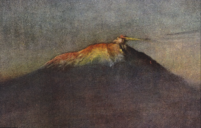
MONS VINOGRADOV BY NASA APOLLO 17 MISSION


http://wanderingvertexes.blogspot.com

NASA APOLLO 17 MISSION ( 1972) 
Mons Vinogradov  (1, 400 m  / 1, 4 km - 4, 593ft / 0,86 mi)
The Moon 

 In Mons Vinogradov seen  from Apollo 17 spaceship during the Moon approach, 1972, Arizona State University, 
Apollo Image Archive

The mountain 
Mons Vinogradov  (1, 400 m  / 1, 4 km - 4, 593ft / 0,86 mi) is a rugged massif that is located on the lunar mare where Oceanus Procellarum to the southwest joins Mare Imbrium to the east. There are three primary peaks in this formation, which rise to altitudes of 1.0–1.4 km above the surface. To the east of this rise is the crater Euler, and to the southeast is an area of rugged ground that reaches the Montes Carpatus range. The Carpatus mountain range forms the southwest boundary of the Mare Imbrium.
The selenographic coordinate of Mons Vinogradov is 22.4 N, 32.4 W, and it has a maximum diameter of 25 km at the base. It was named after Aleksandr P. Vinogradov. This mountain was formerly named Euler Beta (β), or Mons Euler.
In the rugged ground just to the southeast of this mountain is a set of tiny craters that have been assigned names by the IAU. These are listed in the table below.

The mission
Apollo 17 was the final mission of NASA's Apollo program.
Launched at 12:33 a.m. Eastern Standard Time (EST) on December 7, 1972, with a crew made up of Commander Eugene Cernan, Command Module Pilot Ronald Evans, and Lunar Module Pilot Harrison Schmitt, it was the last use of Apollo hardware for its original purpose; after Apollo 17, extra Apollo spacecraft were used in the Skylab and Apollo–Soyuz programs.
Apollo 17 was the first night launch of a U.S. human spaceflight and the final manned launch of a Saturn V rocket. It was a "J-type mission" which included three days on the lunar surface, extended scientific capability, and the third Lunar Roving Vehicle (LRV). While Evans remained in lunar orbit in the Command/Service Module (CSM), Cernan and Schmitt spent just over three days on the Moon in the Taurus–Littrow valley and completed three moonwalks, taking lunar samples and deploying scientific instruments. Evans took scientific measurements and photographs from orbit using a Scientific Instruments Module mounted in the Service Module.
The landing site was chosen with the primary objectives of Apollo 17 in mind: to sample lunar highland material older than the impact that formed Mare Imbrium, and investigate the possibility of relatively new volcanic activity in the same area.  Cernan, Evans and Schmitt returned to Earth on December 19 after a 12-day mission.
Apollo 17 is the most recent manned Moon landing and the most recent time humans travelled beyond low Earth orbit.  It was also the first mission to have no one on board who had been a test pilot; X-15 test pilot Joe Engle lost the lunar module pilot assignment to Schmitt, a scientist. 
The mission broke several records: the longest moon landing, longest total extravehicular activities (moonwalks),  largest lunar sample, and longest time in lunar orbit.
_______________________________
2018 - Wandering Vertexes...
by Francis Rousseau 

Tuesday, November 6, 2018

PUEBLO PEAK BY AKSELI GALLEN-KALLELA


AKSELI GALLEN KALLELA  (1865-1931)
Pueblo Peak  (2,631m - 8,632ft)
United States of America (Oregon / Nevada) 

In  Taos Mountains covered by clouds  (Taos vuoret pilvien peitossa), oil on canvas, 1924. Kansallisgalleria 

The mountain 
Pueblo Peak (2,631m - 8,632ft) to Pueblo Mountain is the highest point of the Pueblo Mountains, a remote mountain range in the United States located mostly in southeastern Oregon and partially in northwestern Nevada. Most land in the Pueblo Mountains is managed by the federal Bureau of Land Management.
While there is no designated wilderness area in the Pueblo Mountains, traveling in the mountains can be very challenging. The Desert Trail runs through the mountains; however, it is not a developed hiking trail. The route is simply marked by rock cairns that serve as guideposts. The cairns were built as a cooperative venture between the Bureau of Land Management, the Oregon Parks and Recreation Department, and the Desert Trail Association (a private organization). The Desert Trail Association publishes a topographic map for hikers that gives directions for orienteering from cairn to cairn.
Cattle and sheep grazing in the Pueblo Mountains began when the first ranches were established along the eastern edge of the mountains in the mid-1860s.
Miners were among the first to explore the Pueblo Mountains. There are at least 18 locations where mining took place in the past.
Wind power is now being explored in the Pueblo Mountains. The test allowed a private wind energy company to install, operate, and maintain two meteorological poles.

The painter 
Akseli Gallen-Kallela was a Swedish-speaking Finnish painter who is best known for his illustrations of the Kalevala, the Finnish national epic. His work was considered very important for the Finnish national identity. He changed his name from Gallen to Gallen-Kallela in 1907. In 1884 he moved to Paris, to study at the Académie Julian and became friends with the Finnish painter Albert Edelfelt, the Norwegian painter Adam Dörnberger, and the Swedish writer August Strindberg.
In December 1894, Gallen-Kallela moved to Berlin to oversee the joint exhibition of his works with the works of Norwegian painter Edvard Munch. Here he became acquainted with the Symbolists.
On his return from Germany, Gallen studied print-making and visited London to deepen his knowledge, and in 1898 studied fresco-painting in Italy.
For the Paris World Fair in 1900, Gallen-Kallela painted frescoes for the Finnish Pavilion. In these frescoes, his political ideas became most apparent.Gallen-Kallela officially finnicized his name to the more Finnish-sounding Akseli Gallen-Kallela in 1907.
In 1909, Gallen-Kallela moved to Nairobi in Kenya with his family, and there he painted over 150 expressionist oil paintings and bought many east African artefacts. But he returned to Finland after a couple of years, because he realized Finland was his main inspiration. Between 1911 and 1913 he designed and built a studio and house at Tarvaspää, about 10 km northwest of the centre of Helsinki.
From December 1923 to May 1926, Gallen-Kallela lived in the United States, where an exhibition of his work toured several cities, and where he visited the Taos art-colony in New Mexico to study indigenous American art. In 1925 he began the illustrations for his "Great Kalevala". This was still unfinished when he died of pneumonia in Stockholm on 7 March 1931, while returning from a lecture in Copenhagen, Denmark
His studio and house at Tarvaspää was opened as the Gallen-Kallela Museum in 1961

_______________________________
2018 - Wandering Vertexes...
by Francis Rousseau 

Monday, November 5, 2018

MOUNT EMIN PHOGRAPHED IN 1906 BY VITTORIO SELLA


VITTORIO SELLA (1859-1943) 

Mount Emin (4,798 m -  15,741 ft) 
 Congo - Uganda border 

In Mt Emin seen from the Iolanda Glacier, photo  from the book  Ruwenzori-Africa,  1908 published by Dutton and Company - New York 


The mountain Mount Emin (4,798 m -  15,741 ft)  is one of the six mountains in the Ruwenzori mountain range and is located in Congo-Kinshasa on the border with Uganda. Emin and Mount Gessi , located in Uganda east of the border, are located on either side of a long narrow valley running north-south. Emin has two peaks called Umberto (4 798 meters) and Kraepelin (4 791 meters). The mountain forms a rocky north-south hill with the higher peak at the southern end. Like Gessi, Emin is north of the triangle formed by the tops of Stanleys , Spekes , and Bakers. Its ascent  was completed in 1906  by Luigi Amedo di Savoia, J. Petigax and L Petigax. The photo aboce is dating from this period The photographerVittorio Sella is a mountain italian climber and photographer who took his passion for mountains from his uncle, Quintino Sella, founder of the Italian Alpine Club.  He accomplished many remarkable climbs in the Alps, the first wintering in the Matterhorn and Mount Rose (1882) and the first winter crossing of Mont Blanc (1888).He took part in various expeditions outside Italy:- Three in the Caucasus in 1889, 1890 and 1896 where a summit still bears his name;- The ascent of Mount Saint Elias in Alaska in 1897- Sikkim and Nepal in 1899- Possibly climb Mount Stanley in Uganda in 1906 during an expedition to the Rwenzori- Recognition at K2  and Mustagh Tower in 1909- In Morocco in 1925.During expeditions in Alaska, Uganda and Karakoram (K2-Chogolisa), he accompanied the Duke of Abruzzi, Prince Luigi Amedeo di Savoia.Sella continues the practice of climbing into his old age, completing his final attempt in the Matterhorn at the age of 76; a climb he had to interrupt the rise following an accident in which one of his guides injured. He died in his hometown during World War II.  His photographic collection is now managed by the Sella Foundation.His photos mountain are still  considered today to be among the finest ever made.Jim Curran believes that "Sella remains probably the greatest photographer of the mountain.  His name is synonymous with technical perfection and aesthetic refinement. "The quality of the pictures of Vittorio Sella is partly explained by the use of a view camera 30 × 40 cm, despite the difficulty of the transportation of such a device, both heavy and fragile in places inaccessible; to be able to transport it safely, he had to make special pieces that can be stored in saddle bags.  His photographs have been widely distributed, either through the press or in the galleries, and were unanimously celebrated; Ansel Adams, who was able to admire thirty-one in an exhibition that was organized at Sella American Sierra Club, said they inspired him "a religious kind of sense of wonder."  Many of his pictures were taken in the mountains for the very first time in the History, which give them a much artistic, historical  but also scientific value ; for example, one could measure the decline in the Rwenzori glaciers in Central Africa._______________________________
2018 - Wandering Vertexes...
by Francis Rousseau 
Sunday, November 4, 2018

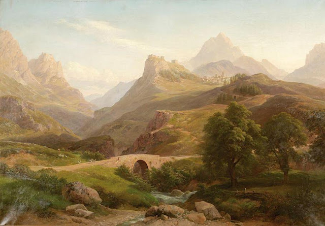
MOUNT ABRUPT BY EUGENE VON GUERARD


EUGENE VON GUERARD  (1811-1901)
Mount Abrupt (805 m - 2,641ft)
Australia  (Victoria) 

 In Mount Abrupt, The Crampians, Victoria, Private collection 

The mountain 
Mount Abrupt (805 m - 2,641ft) is located in Grampians National Park Victoria. This Mount Abrupt hike, suitable for fit and energetic walkers, can involve water crossings, slippery track surfaces, rock hopping and rock scrambling. The steep track winds its way through heathy woodland to a ridge. Follow the ridge over rock slabs and stunted montane vegetation to the summit, for one of the most spectacular views.
A large landside caused by the storm event in January 2011 badly damaged this walking track. Parks Victoria has worked hard to rebuild this track but further rain could cause movement of soil and rock over the track.

The painter 
Johann Joseph Eugene von Guerard was an Austrian-born artist, active in Australia from 1852 to 1882. Known for his finely detailed landscapes in the tradition of the Düsseldorf school of painting, he is represented in Australia's major public galleries, and is referred to in the country as Eugene von Guerard. In 1852 von Guerard arrived in Victoria, Australia, determined to try his luck on the Victorian goldfields. As a gold-digger he was not very successful, but he did produce a large number of intimate studies of goldfields life, quite different from the deliberately awe-inspiring landscapes for which he was later to become famous. Realizing that there were opportunities for an artist in Australia, he abandoned the diggings and was soon undertaking commissions recording the dwellings and properties of wealthy pastoralists.
By the early 1860s, von Guerard was recognized as the foremost landscape artist in the colonies, touring Southeast Australia and New Zealand in pursuit of the sublime and the picturesque.  He is most known for the wilderness paintings produced during this time, which are remarkable for their shadowy lighting and fastidious detail.  Indeed, his View of Tower Hill in south-western Victoria was used as a botanical template over a century later when the land, which had been laid waste and polluted by agriculture, was systematically reclaimed, forested with native flora and made a state park. The scientific accuracy of such work has led to a reassessment of von Guerard's approach to wilderness painting, and some historians believe it likely that the landscapist was strongly influenced by the environmental theories of the leading scientist Alexander von Humboldt. Others attribute his 'truthful representation' of nature to the criterion for figure and landscape painting set by the Düsseldorf Academy.
_______________________________
2018 - Wandering Vertexes...


by Francis Rousseau 

Saturday, November 3, 2018

GERLACHOVSKY STIT BY STANISLAW GALEK

http://wanderingvertexes.blogspot.com

STANISLAW GALEK (1876-1961)
Gechovský štít (2,654 m - 8,709 ft)
Slovakia- Poland

  In Turnie tatrzanskie, watercolor, Private collection 


The mountain 
 Gerlachovský štít (2,654 m - 8,709 ft), Gerlach Peak in english, is the highest peak in the High Tatras, in Slovakia, and in the whole 1,500 km (930 mi) long Carpathian mountain chain. The pyramidal shape of the massif is marked by a huge cirque. Despite its relatively low elevation, the about 2,000 m vertical rise from the valley floor makes Gerlachovský štít  soar. Mistaken for an average mountain in the rugged High Tatras range in the more distant past, it has since played a symbolic role in the eyes of the rulers and populations of several Central European nations, to the point that between the 19th and mid-20th century, it had four different names with six name reversals. It managed to be the highest mountain of the Kingdom of Hungary, and of the countries of Czechoslovakia and Slovakia within the span of only about two decades of the 20th century.
Gerlachovský štít  shares its geology and ecology with the rest of the High Tatras, but provides a worthwhile environment for biologists as the highest ground anywhere in Europe north of the parallel linking approximately Munich, Salzburg, and Vienna. With the travel restrictions imposed by the Eastern Bloc, the mountain was particularly treasured as the loftiest point available to climb to by Czechs, East Germans, Hungarians, Poles, and Slovaks. It continues to attract its share of visitors although the local authorities have been continually adding new restrictions on access.

The painter 
Stanisław Gałek was a Polish painter and sculptor, and... designer of kilims. In 1896 he graduated from the Vocational School of Wood Industry in Zakopane and then taught in it a drawing, being an assistant to Edgar Kováts . In 1899 he began studies at the Krakow Academy of Fine Arts in the studios of Jacek Malczewski and Jan Stanisławski. A year later, he stopped studying in Kraków and left for Munich , where he began studying at Königliche Kunstgewerbeschule.
Later, he studied at the Paris École Nationale des Beaux-Arts in the studio of Jean-Léon Gérôme.
In 1910, he left to create in Italy and the Crimea . In 1912 he received the work of a drawing teacher at a vocational school in Kołomyja, from where he returned to Zakopane in 1916 and again began to teach at the School of Wood Industry.
From 1931, he devoted himself only to painting.
 He exhibited his works for the first time in 1900, he was a regular participant in exhibitions organized by the Krakow Society of Friends of Fine Arts and from 1907 by the Society for the Encouragement of Fine Arts. He took part in an international exhibition organized in 1910 in Berlin, and in 1929 in the Poznań Universal National Exhibition. In 1930 he exhibited in Budapest and Vienna.  In 1960, the Warsaw Zachęta exhibition hosted an individual jubilee exhibition showing the full artistic output of Stanisław Gałek. He was one of the most outstanding painters showing the Tatras , especially the area around Morskie Oko.
In addition, he carved and designed patterns of kilims for the Kilim association in Zakopane.

_______________________________
2018 - Wandering Vertexes...
Un blog de Francis Rousseau

Friday, November 2, 2018

FUJIYAMA BY EVE DREWELOWE

 http://wanderingvertexes.blogspot.com

EVE DREWELOWE (1899-1988)
Fujiyama / 富士山 (3, 776 m -12,389 ft)
Japan

 In Mont Fuji from the lake Hakone, 1928, Drawing , University of Iowa school of art and history 

The mountain 
Mount Fuji or Fujiyama (富士山)  (3,776 m - 12,389 ft) is the highest mountain peak in Japan, located on Honshu Island. Several names are attributed to it: "Fuji-san", "Fujiyama" or, redundantly, "Mt. Fujiyama". Usually Japanese speakers refer to the mountain as "Fuji-san".  The other Japanese names for Mount Fuji,  have become obsolete or poetic like: Fuji-no-Yama (The Mountain of Fuji), Fuji-no-Takane (The High Peak of Fuji), Fuyō-hō (The Lotus Peak), and Fugaku...
Mount Fuji is an active stratovolcano that last erupted in 1707–08. Mount Fuji lies about 100 kilometres (60 mi) south-west of Tokyo, and can be seen from there on a clear day.
Mount Fuji's exceptionally symmetrical cone, which is snow-capped several months a year, is a well-known symbol of Japan and it is frequently depicted in art and photographs, as well as visited by sightseers and climbers.
Mount Fuji is one of Japan's Three Holy Mountains along with Mount Tate and Mount Haku. It is also a Special Place of Scenic Beauty and one of Japan's Historic Sites.
It was added to the World Heritage List as a Cultural Site on June 22, 2013. As per UNESCO, Mount Fuji has “inspired artists and poets and been the object of pilgrimage for centuries”. 
UNESCO recognizes 25 sites of cultural interest within the Mt. Fuji locality. 

The painter 
 Eve Drewelowe was an American painter. Her career spanned six decades and produced more than 1,000 works of art in oil, watercolor, pen and ink and other media in styles that included impressionism, social realism and abstraction.
Despite dabbling with other artistic styles, Drewelowe always showed an inclination toward landscapes.  She once said: “my waking thought from an embryo on was my need to be an artist.” 
Though never known to have used the word to describe herself, Eve Drewelowe is often considered a feminist artist. Her personal life exhibited feminist themes: the artist retained her maiden name and publicly stated a disinterest in housework and parenting. Drewelowe chose not to take her husband’s last name because in her opinion it should not matter to others whether she is married or not. When Drewelowe and Van Ek returned from their travels and started building a house together.  She did not want to be involved in the pleasantries of being the dean’s wife, especially hosting dinner parties, so she specified to have the house built lacking a dining room.  She always maintained that she did not want to have children of her own, much to her mother’s dismay.
Although Drewelowe is mainly renowned in Colorado and Iowa, she had solo exhibitions all over the country. Her work was shown at National Association of Women Artists exhibitions, the Art Institute of Chicago, the Denver Art Museum, the National Museum of Women in the Arts and numerous other esteemed institutions. Although women had been in the profession of art for 20–30 years at the beginning of Drewelowe’s career, she still faced opposition and sexism. Critics believe that she could have been much more acclaimed had she not been a woman and had she not fallen ill at the peak of her career. Others believe that her “reincarnation” and transition to abstract paintings increased Drewelowe’s popularity as an artist by keeping her relevant in an evolving artistic world.

_______________________________
2018 - Wandering Vertexes...
by Francis Rousseau 


Thursday, November 1, 2018

NORTHCAPE PAINTED BY THOROLF HOLMBOE


http://wanderingvertexes.blogspot.com

THOROLF HOLMBOE (1866-1935) 
North Cape (307m - 1,007 ft)
Norway

In Midnight Sun at the North Cap, oil on canvas

The cliff 
North Cape (307m - 1,007 ft), Nordkapp in  Norwegian, named by the Englishman Steven Borough, captain of the Edward Bonaventure, which sailed past in 1553 in search of the Northeast Passage, is a cape on the northern coast of the island of Magerшya in Northern Norway. The cape is in Nordkapp Municipality in Finnmark county, Norway. The European route E69 highway has its northern terminus at North Cape, since it is a popular tourist attraction. The cape includes a 307 metres (1,007 ft) high cliff with a large flat plateau on top where visitors can stand and watch the midnight sun or the views of the Barents Sea to the north.
The North Cape is the point where the Norwegian Sea, part of the Atlantic Ocean, meets the Barents Sea, part of the Arctic Ocean. The midnight sun can be seen from 14 May to the 31st of July.
During winter season, it is also possible to visit North Cape, however the last stretch of road is only open for convoy driving at fixed hours. The road all the way through Norway up to North Cape is kept open during winter and is accessible to regular vehicles with some specific winter precautions being required to deal with the hard snow and wind conditions that may occur in winter.
Before this, E69 was the only winter closed E road in Europe.

The painter 
Thorolf Holmboe (10 May 1866 – 8 March 1935) was a Norwegian painter, illustrator and designer.
He was born in Vefsn, in Nordland county. He studied under Hans Gude in Berlin between 1886 and 1887 and Fernand Cormon in Paris between 1889 and 1891. He was inspired by many different styles at different points in his career, including Naturalism, Neo-romanticism, Realism and Impressionism. He is represented with thirteen works in the National Gallery of Norway.

____________________________________________
2018 - Wandering Vertexes...
by Francis Rousseau