google.com, pub-0288379932320714, DIRECT, f08c47fec0942fa0 GRAVIR LES MONTAGNES... EN PEINTURE: ROCK FORMATIONS
Showing posts with label ROCK FORMATIONS. Show all posts

Wednesday, December 16, 2020

MONT GAUSSIER (4) AND THE ALPILLES BY VINCENT VAN GOGH


VINCENT VAN GOGH (1853-1890) Mont Gaussier (306 m -1,004 ft) France  In Mas au milieu des oliviers dans les Alpilles, St Rémy de Provence, oil on canvas, 1889,  Private collection


VINCENT VAN GOGH (1853-1890)
Mont Gaussier (306 m -1,004 ft)
France

In Mas au milieu des oliviers dans les Alpilles, St Rémy de Provence, oil on canvas, 1889, 
Private collection


About the painting
During his internment in the Saint-Paul-de-Mausole asylum in Saint-Rémy-de-Provence, Van Gogh seized the surroundings to nourish his artistic geography. He tirelessly paints and draws new Provencal motifs: cypress trees, olive groves and hills. With the Alpilles chain and the Mont Gaussier rising behind the asylum buildings, the painter has the opportunity to represent this mountain range as well as the farms (Mas in french) nearby.  I this one the Mont Gaussier is in the background of the farm, probably situated on theVia Aurelia, the antique roman road going from St Rémy de Provence to Arles...  

The mountain
The Mont Gaussier (306 m -1,004 ft) is a summit of the Alpilles located south of the city of Saint-Rémy-de-Provence, France. Today, the place of passage of many hikers who cross it by the GR6, Mount Gaussier was very early used as habitat by protohistoric populations, before having at its summit a medieval castle, nowadays disappeared. Mount Gaussier is made of crystalline limestone, white and hard. One finds in the soil the trace of many fossils. This type of summit is characteristic of the Alpilles range of mountains, especially on the north face.
The first traces of habitation on Mount Gaussier are ancient. In 1996, three sites dating from Protohistory were discovered at the summit and on the slopes. This is what emerges from the study of stones, tiles, ceramics and shards of amphora found on the premises. Moreover, the foundation of a wall was identified at the top during the same prospecting.
Most of the human activity of antiquity at Mount Gaussier nevertheless concentrated at the foot of it, since it was there that was built the Salyan city of Glanum (today Saint-Remy de Provence). Research carried out in 1996 and 1997 revealed that the well-preserved remains of a protohistoric rampart with towers have been cleared in several places, particularly on the ridges which dominate to the north-east and south-west the Saint-Clerg and at the foot of Mount Gaussier. The system of rampart which encircled the city in the 1st and 2nd centuries BC. J.-C. leaned on the cliffs of the mount Gaussier which border it on a hundred meters. It is also believed that Mount Gaussier, by its situation, could be used as an acropolis because of its plateau surrounded by cliffs and that its access from Glanum was made possible by a narrow corridor.
If, according to the archaeologist Henri Rolland, some families occupied the Alpilles range, on the slopes of Mount Gaussier, between the first Iron Age and the end of Antiquity, but also in the High Middle Ages, only the foot and the summit of the mountain were occupied in the following centuries, especially in the 5th and 6th centuries. It was here that a part of the inhabitants of Glanum took up residence after the ruin of the ancient city in the alluvial deposits of the mountain.
Mount Gaussier, like Glanum, then in ruins, and Saint-Remy-de-Provence, became property of the church of Avignon at the end of the 9th century in a county of Provence powered by Count Thibert.
It is possible to reach the Mount Gaussier from the ruins of Glanum or from La Caume by the GR6 climbing previously metal ladders.

The painter
Vincent Willem van Gogh was a Dutch Post-Impressionist painter who is among the most famous and influential figures in the history of Western art. In just over a decade he created about 2100 artworks, including around 860 oil paintings, most of them in the last two years of his life. They include landscapes, still lifes, portraits and self-portraits, and are characterized by bold, symbolic colours, and dramatic, impulsive and expressive brushwork that contributed to the foundations of modern art. He died by suicide at 37, following years of mental illness and poverty.
Born into an upper-middle-class family, Van Gogh drew as a child and was serious, quiet and thoughtful. As a young man he worked as an art dealer, often travelling, but became depressed after he was transferred to London. He turned to religion, and spent time as a missionary in southern Belgium. Later he drifted in ill health and solitude. He took up painting in 1881 having moved back home with his parents. His younger brother Theo supported him financially, and the two kept up a long correspondence by letter.
More about Vincent Van Gogh

_______________________________

2020 - Wandering Vertexes...
by Francis Rousseau

Saturday, November 14, 2020

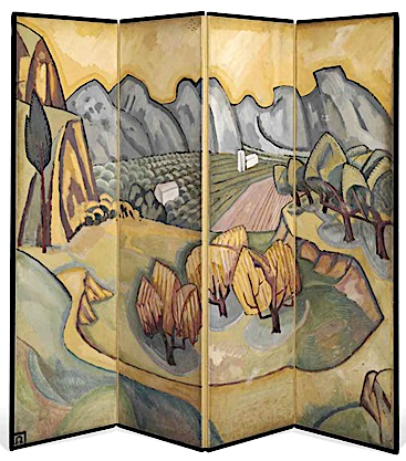
THE ALPILLES MASSIF PAINTED BY ROGER FRY

https://wanderingvertexes.blogspot.com/2020/11/the-alpilles-massif-painted-by-roger-fry.html


ROGER FRY (1866 -1934)
Les Alpilles  / Les  Opies  (496 m-1,627ft)
France (Provence) 


In Les Alpilles - Provençal screen,  1913, Private collection  


The mountains   

The Alpilles massif is located in the south of France, in the Bouches-du-Rhône department (Provence-Alpes-Côte d'Azur region), about sixty kilometers north of Marseille. It extends along an east-west axis for about 25 km, from the Rhône valley to the Durance valley. Several summit areas make it up: - The main part of the massif, called the Alpilles (“Little Alps”), stretches from the Saint-Gabriel chapel in Tarascon to the road linking Aureille to Eygalières.

- Les Opies  (496 m-1,627ft) east of the Alpille, is made up of three small peaks: the crêtes des Opies, Mont Menu and Défends (municipalities of Eyguières, Lamanon and Aureille).
- The  Rochers de la Pène) are a narrow link stretching to the south of the massif from which it is separated by the departmental road 17 (Arles-Paradou) .
- Les Costières, located in the town of Saint-Martin-de-Crau, is a plateau that marks the southern limit of the massif. This one gains altitude as one progresses towards the north, and slopes steeply on the marshes of Baux, to the south of the rocks of Pène.
- Les Chainons are a set of low altitude peaks (around 50 meters) between Aureille and Montmajour characterized by the sets of valleys they shelter. The Caisses de Jean-Jean are perhaps the best known of those hills

- The Mont Gaussier (306m -1,004 ft), located south of the city of Saint-Rémy-de-Provence. Today, the place of passage of many hikers who cross it by the GR6, Mount Gaussier was very early used as habitat by protohistoric populations, before having at its summit a medieval castle, nowadays disappeared. Mount Gaussier is made of crystalline limestone, white and hard. One finds in the soil the trace of many fossils. This type of summit is characteristic of the Alpilles range of mountains, especially on the north face.


The painter
Roger Eliot Fry was an English painter and critic, and a member of the Bloomsbury Group. Establishing his reputation as a scholar of the Old Masters, he became an advocate of more recent developments in French painting, to which he gave the name Post-Impressionism. He was the first figure to raise public awareness of modern art in Britain, and emphasised the formal properties of paintings over the "associated ideas" conjured in the viewer by their representational content. He was described by the art historian Kenneth Clark as "incomparably the greatest influence on taste since Ruskin ... In so far as taste can be changed by one man, it was changed by Roger Fry". The taste Fry influenced was primarily that of the Anglophone world, and his success lay largely in alerting an educated public to a compelling version of recent artistic developments of the Parisian avant-garde.
As a painter Fry was experimental (his work included a few abstracts), but his best pictures were straightforward naturalistic portraits, although he did not pretend to be a professional portrait - painter. In his art he explored his own sensations and gradually his own personal visions and attitudes asserted themselves. His work was considered to give pleasure, 'communicating the delight of unexpected beauty and which tempers the spectator's sense to a keener consciousness of its presence'. Fry did not consider himself a great artist, 'only a serious artist with some sensibility and taste'. 

___________________________

2020 - Wandering Vertexes...
by Francis Rousseau

Wednesday, November 11, 2020

THE FALAISES D'ETRETAT PAINTED BY GEORGES BRAQUE

https://wanderingvertexes.blogspot.com/2020/11/the-falaises-detretat-painted-by.html
 

GEORGES BRAQUE (1882-1963)
The Falaises d'Etretat (70 to 90 m - 230 to 300 ft)
France (Normandie)

 In Les Falaises d'Etretat, 1930, oil on canvas

The cliffs 
The Falaise d'Etretat (Etretat Chalk Complex), as it is known, consists of a complex stratigraphy of Turonian and Coniacian chalks. Some of the cliffs are as high as 90 metres (300 ft).  Etretat is best known for its chalk cliffs, including three natural arches and a pointed formation called L'Aiguille (the Needle), which rises 70 m- 230 ft above the sea.  L'arche et L'aiguille  (The Ark and the Needle) above.  An underground river, then marine erosion formed a natural arch and a estimated 55 meter to 70 meters  high needle, relic piece of the cliff. Maurice Leblanc describes it in these terms in his novel The Hollow Needle (1909) "An enormous roach, more than eighty meters high, colossal obelisk, plumb on its granite base"  At his time, the site already attracted many tourists among them "lupinophiles" admirers of Arsene Lupine: American students came for the key to the cave, where the "gentleman burglar" had found the treasure of kings of France. 


The Painter
Georges Braque (1882-1963) was a major 20th-century French painter, collagist, draughtsman, printmaker and sculptor. His most important contributions to the history of art were in his alliance with Fauvism from 1905, and the role he played in the development of Cubism. Braque's work between 1908 and 1912 is closely associated with that of his colleague Pablo Picasso. Their respective Cubist works were indistinguishable for many years, yet the quiet nature of Braque was partially eclipsed by the fame and  notoriety of Picasso. Braque believed that an artist experienced beauty "… in terms of volume, of line, of mass, of weight, and through that beauty [he] interpret[s] [his] subjective impression".   He described "objects shattered into fragments... [as] a way of getting closest to the object...Fragmentation helped me to establish space and movement in space”. He adopted a monochromatic and neutral color palette in the belief that such a palette would emphasize the subject matter.  Although Braque began his career painting landscapes, during 1908 he, alongside Picasso, discovered the advantages of painting still lifes instead. Braque explained that he “... began to concentrate on still lifes, because in the still-life you have a tactile, I might almost say a manual space... This answered to the hankering I have always had to touch things and not merely see them... In tactile space you measure the distance separating you from the object, whereas in visual space you measure the distance separating things from each other. This is what led me, long ago, from landscape to still-life”  A still life was also more accessible, in relation to perspective, than landscape, and permitted the artist to see the multiple perspectives of the object. Braque's early interest in still lifes revived during the 1930s.
During the period between the wars, Braque exhibited a freer, more relaxed style of Cubism, intensifying his color use and a looser rendering of objects. However, he still remained committed to the cubist method of simultaneous perspective and fragmentation. In contrast to Picasso, who continuously reinvented his style of painting, producing both representational and cubist images, and incorporating surrealist ideas into his work, Braque continued in the Cubist style, producing luminous, other-worldly still life and figure compositions. By the time of his death in 1963, he was regarded as one of the elder statesmen of the School of Paris, and of modern art.

Saturday, September 5, 2020

MONT GAUSSIER (3) PAINTED BY VINCENT VAN GOGH


VINCENT VAN GOGH  (1853-1890) 
  Mont Gaussier (306 m -1,004 ft)  
France

In  Entrée de la carrière près de Saint-Rémy (et Mont Gaussier), 1889,  
Oil on canvas 52.0 x 64.0 cm. Private collection 
 
About the painting
During his internment in the Saint-Paul-de-Mausole asylum in Saint-Rémy-de-Provence, Van Gogh seized the surroundings to nourish his artistic geography. He tirelessly paints and draws new Provencal motifs: cypress trees, olive groves and hills. With the Alpilles chain and the Mont Gaussier rising behind the asylum buildings, the painter has the opportunity to represent this mountain range as well as the quarry which is nearby. Of the latter, he gave two performances: one painted in mid-July - shortly after he suffered a new seizure - the other (the one above) in October in which  Mount Gaussier, the highest moutain of Les Alpilles appears on right. 

The mountain
The Mont Gaussier (306 m -1,004 ft) is a summit of the Alpilles located south of the city of Saint-Rémy-de-Provence, France. Today, the place of passage of many hikers who cross it by the GR6, Mount Gaussier was very early used as habitat by protohistoric populations, before having at its summit a medieval castle, nowadays disappeared. Mount Gaussier is made of crystalline limestone, white and hard. One finds in the soil the trace of many fossils. This type of summit is characteristic of the Alpilles range of mountains, especially on the north face.
The first traces of habitation on Mount Gaussier are ancient. In 1996, three sites dating from Protohistory were discovered at the summit and on the slopes. This is what emerges from the study of stones, tiles, ceramics and shards of amphora found on the premises. Moreover, the foundation of a wall was identified at the top during the same prospecting.
Most of the human activity of antiquity at Mount Gaussier nevertheless concentrated at the foot of it, since it was there that was built the Salyan city of Glanum (today Saint-Remy de Provence). Research carried out in 1996 and 1997 revealed that the well-preserved remains of a protohistoric rampart with towers have been cleared in several places, particularly on the ridges which dominate to the north-east and south-west the Saint-Clerg and at the foot of Mount Gaussier. The system of rampart which encircled the city in the 1st and 2nd centuries BC. J.-C. leaned on the cliffs of the mount Gaussier which border it on a hundred meters. It is also believed that Mount Gaussier, by its situation, could be used as an acropolis because of its plateau surrounded by cliffs and that its access from Glanum was made possible by a narrow corridor.
If, according to the archaeologist Henri Rolland, some families occupied the Alpilles range, on the slopes of Mount Gaussier, between the first Iron Age and the end of Antiquity, but also in the High Middle Ages, only the foot and the summit of the mountain were occupied in the following centuries, especially in the 5th and 6th centuries. It was here that a part of the inhabitants of Glanum took up residence after the ruin of the ancient city in the alluvial deposits of the mountain.
Mount Gaussier, like Glanum, then in ruins, and Saint-Remy-de-Provence, became property of the church of Avignon at the end of the 9th century in a county of Provence powered by Count Thibert.
It is possible to reach the Mount Gaussier from the ruins of Glanum or from La Caume by the GR6 climbing previously metal ladders.

The painter
Vincent Willem van Gogh was a Dutch Post-Impressionist painter who is among the most famous and influential figures in the history of Western art. In just over a decade he created about 2100 artworks, including around 860 oil paintings, most of them in the last two years of his life. They include landscapes, still lifes, portraits and self-portraits, and are characterized by bold, symbolic colours, and dramatic, impulsive and expressive brushwork that contributed to the foundations of modern art. He died by suicide at 37, following years of mental illness and poverty.
Born into an upper-middle-class family, Van Gogh drew as a child and was serious, quiet and thoughtful. As a young man he worked as an art dealer, often travelling, but became depressed after he was transferred to London. He turned to religion, and spent time as a missionary in southern Belgium. Later he drifted in ill health and solitude. He took up painting in 1881 having moved back home with his parents. His younger brother Theo supported him financially, and the two kept up a long correspondence by letter.
More about Vincent Van Gogh

_______________________________

2020 - Wandering Vertexes...
by Francis Rousseau
Wednesday, September 2, 2020

MITRE PEAK / RAHOTU PAINTED BY LAURENCE WILLIAM WILSON


LAURENCE WILLIAM  WILSON  (1851-1912)
Mitre Peak/ Rahotu (1,683m - 5,522 ft)
New Zealand 

In Mitre Peak, Milford Sound, oil on canvas,  Christchurch Art Gallery, New Zealand

The mountain
Mitre Peak/ Rahotu (1,683m - 5,522 ft) is an iconic mountain in the South Island of New Zealand, located on the shore of Milford Sound. It is one of the most photographed peaks in the country. The distinctive shape of the peak in southern New Zealand gives the mountain its name, after the mitre headwear of Christian bishops. It was named by Captain John Lort Stokes of the HMS Acheron.
Part of the reason for its iconic status is its location. Close to the shore of Milford Sound, in the Fiordland National Park in the southwestern South Island, it is a stunning sight. The mountain rises near vertically from the water of Milford Sound, which technically is a fjord.
The peak is actually a closely grouped set of five peaks, with Mitre Peak not even the tallest one, however from most easily accessible viewpoints, Mitre Peak appears as a single point.
Milford Sound is part of Te Wahipounamu, a World Heritage Site as declared by UNESCO.
The only road access to Milford Sound is via State Highway 94, in itself one of the most scenic roads in New Zealand

The painter
Laurence William Wilson emigrated to Auckland in 1877 and then travelled extensively to settle in Dunedin in 1884. He painted in both oils and watercolours, became a painting companion of George O'Brien and a teacher. One of his pupils was the Dunedin artist Alfred O'Keefe. In 1895, LW Wilson together with Grace Joel, Alfred O'Keefe, Jane Wimperis and Girolami Nerli formed the Easel Club , a breakaway from the Dunedin Establishment, which offered a programme of special classes and the introduction of a professional lady model for life drawing. In 1904 LW Wilson left Dunedin for Melbourne where he spent 5 months on a commissioned painting of the city before he set out for England, eventually returning to New Zealand via India and Africa. He exhibited with the Canterbury Society of Arts in 1882 and the Otago Art Society between 1994 and 1904. His work was included in the NZ and South Seas Exhibition Dunedin 1889-90 and at the St Louis Exposition in 1904. LW Wilson is represented in the collections of all the major public galleries in New Zealand.

___________________________________________

2020 - Wandering Vertexes...
by Francis Rousseau


Sunday, July 26, 2020

BLAKCHEAD / MONHEGAN PAINTED BY NICHOLAS ROERICH


NICHOLAS ROERICH (1874-1947)
Blackhead (50 m-150 ft) 
United States of America (Maine)

In Monhegan, Maine From Ocean series,  1922, Roerich Museum NYC


The rock
Blackhead (50m-150 ft) are northside cliffs situated on Monhegan, Manana Island, that have drawn the interest of many artists. The beginnings of the art colony on Monhegan date to the mid-19th century; by 1890, it was firmly established. Two of the early artists in residence from the 1890s, William Henry Singer (1868–1943) and Martin Borgord (1869–1935), left Monhegan to study at the Académie Julian in Paris in 1901. Among many early members who found inspiration on the island were summer visitors from the New York School of Art and the Pennsylvania Academy of the Fine Arts, such as Robert Henri, Frederick Waugh, George Bellows, Edward Hopper and Rockwell Kent. The Monhegan Museum celebrated more the continuing draw of the island for artists in a 2014 exhibit entitled, “The Famous and the Forgotten: Revisiting Monhegan’s Celebrated 1914 Art Exhibition."
Monhegan is a plantation in Lincoln County, Maine, United States, about 12 nautical miles (22 km) off the mainland. The population was 75 at the 2000 census. The plantation comprises its namesake island and the uninhabited neighboring island of Manana. The island is accessible by scheduled boat service from Boothbay Harbor, New Harbor and Port Clyde. It was designated a National Natural Landmark for its coastal and island flora in 1966.

The painter
Nicholas Roerich known also as Nikolai Konstantinovich Rerikh (Никола́й Константи́нович Ре́рих) is quite an important figure of mountain paintings in the early 20th century. He was a Russian painter, writer, archaeologist, theosophist, perceived by some in Russia as an enlightener, philosopher, and public figure. In his youth was he was quite influenced by a movement in Russian society around the occult and was interested in hypnosis and other spiritual practices. His paintings are said to have hypnotic expression.

More about the painter =>

_______________________________

2020 - Wandering Vertexes...
by Francis Rousseau

Friday, July 10, 2020

ELEPHANT CASTLE PAINTED BY JACOBUS HENDRIK PIERNEEF


JACOBUS HENDRIK PIERNEEF (1886-1957)
Elephant Castle (400m-1,300ft) 
South Africa  

 In Elephant Castle, Selati Rivier, Phalaborwa, 1945, oil on canvas 60,5x 76cm, Private collection


The rock formation
Elephant Castle (400m-1,300ft) is part of The Lebombo Mountains, also called Lubombo Mountains are an 800 km-long (500 mi), narrow range of mountains in Southern Africa. The name of the mountains is derived from the Zulu word ubombo meaning "big nose".
They stretch from Hluhluwe in KwaZulu-Natal in the south to Punda Maria in the Limpopo Province in South Africa in the north. Parts of the mountain range are also found in Mozambique and Eswatini.
Geologically, the range is considered a monocline; part of a rifted volcanic margin. The Lebombo monocline was aligned with the Explora Escarpment off-shore Dronning Maud Land, Antarctica, before the break-up of Gondwana. The Lebombo monocline strikes N-S and dips to the east. It is composed of a sequence of Jurassic age volcanic rock, both basaltic lavas and rhyolitic flows and tuffs. The sequence rests on essentially horizontal Karoo Supergroup sedimentary rocks of the Kalahari Craton to the west and is overlain by Cretaceous to recent sediments to the east. The alternating resistant rhyolite and easily eroded basalts produce a series of parallel sharp cuesta ridges separated by savanna plains.
The range is relatively low with heights between 400 m (1,300 ft) and less than 800 m (2,600 ft). The highest peak is the 776 m-high (2,546 ft) Mount Mananga. The 480 m-high (1,570 ft) Longwe is the highest point in the Lebombo Range north of the Letaba River.


The painter
Jacobus Hendrik (Henk) Pierneef (usually referred to as Pierneef) was a South African landscape artist, generally considered to be one of the best of the old South African masters. His distinctive style is widely recognized and his work was greatly influenced by the South African landscape.
Most of his landscapes were of the South African highveld, which provided a lifelong source of inspiration for him. Pierneef's style was to reduce and simplify the landscape to geometric structures, using flat planes, lines and colour to present the harmony and order in nature. This resulted in formalised, ordered and often-monumental view of the South African landscape, uninhabited and with dramatic light and colour.
Pierneef's work can be seen worldwide in many private, corporate and public collections, including the Africana Museum, Durban Art Gallery, Johannesburg Art Gallery, King George VI Art Gallery, Pierneef Museum and the Pretoria Art Gallery.

___________________________________________

2020 - Wandering Vertexes...
by Francis Rousseau


Monday, June 22, 2020

TIOGA PEAK PAINTED BY EDGAR PAYNE


EDGAR PAYNE (1883-1947)
Tioga Peak  (3,513 m - 11,526 ft)  
United States of America (California) 

The mountain
Tioga Peak (3,513 m - 11,526 ft)   is technically outside of Yosemite National Park, a bit north-north-east of Tioga Pass. It is in the Inyo National Forest. Tioga Peak is north of Tioga Pass, at the head of Lee Vining Canyon. Highway 120 goes direct past its south and east slopes. It is easily accessible, a class 1 to class 2 scramble, from Gardisky Lake. The summit is like a rolling dome. It has some of the best views of the Tioga Pass region. Both Mount Dana and Tioga Pass are visible, from the summit.
Tioga Peak is a rounded peak, made of metamorphic rock. Metamorphic rocks make up a large part of the Earth's crust and form 12% of the Earth's land surface.  They are classified by texture and by chemical and mineral assemblage (metamorphic facies).

The painter 
Edgar Alwin Payne was an American Western landscape painter and muralist. He made his way to California for the first time in 1909, at the age of 26. He spent several months painting at Laguna Beach, then headed to San Francisco. In San Francisco he met other artists, including commercial artist Elsie Palmer (1884–1971). On  November 1912, Edgar married Elsie  Palmer.  As a couple they became well known in Chicago's art circle. Between 1915 and 1918-19, Edgar maintained a professional address in Chicago at the Tree Studio Building on East Ohio Street.
He earned his first major commission in 1917. In a bid to attract tourism, the Atchison, Topeka and Santa Fe Railroad asked him to paint the Southwest, along the railroads' trek from Albuquerque to California. This commission not only solidified his reputation as an artist, it also forever linked him to Western America. Although he painted in Europe, he is most remembered for his work from the Four Corners area of the Navajo Nation Reservation, Yosemite, and the California coast. This area, from Taos, New Mexico to the Grand Canyon, became one of Payne's two main inspirations for the next twenty years.
The Santa Fe Railroad commissions were the turn of the century brainchild of William H. Simpson, chief of the railway's advertising department. Starting in 1892, with Thomas Moran, Simpson exchanged travel on the train, along with lodging at railroad hotels and meals at railroad restaurants, and sometimes even cash, for paintings, photographs, pottery, and jewelry. This endeavor lasted for decades and made the Santa Fe one of the largest collectors of southwestern fine art.
His lifelong obsession with the Sierras would lead him to produce a documentary film, “Sierra Journey”. In 1941 he wrote "Composition of Outdoor Painting", a comprehensive book on composition and composition forms. The book also explains landscape painting techniques, color, repetition, rhythm, and value. The seventh edition printing of the work was completed in 2005.

___________________________________________
2020 - Wandering Vertexes...
by Francis Rousseau


Saturday, June 13, 2020

ROCKS OF CYCLOPS ENGRAVED BY JOHN CHAPMAN


JOHN CHAPMAN (active 1792-1823)  
Rocks of Cyclops (914 cm -30 feet)
Italy ( Sicily)

 In  Rocks of Cyclops,  Engraving, 1798.


The formation
The Rocks of Cyclops  (914 cm -30 ft)) in Aci Trezza , in Italy (Sicily) is a fascinating place rich in legends and myths.  Spectacular basaltic The Rocks of the Cyclops,  is considered one of the most important place where discover antiques myths and descirbe on the most famous poem  The Odyssey attributed to Homer . According to legend this was the land where lived a Cyclop, the son of the sea god Poseidon called Polyphemus, one of the popular characters from Homer’s poem, Odyssey. 
It is possible to reach the rocks by boat from the port of the village and the location offers lots of things to do such as snorkelling, underwater fishing and diving. 
Polyphemus the Cyclop also killed a young shepherd named Aci. After his death, the nymph Galatea, who was in love with the shepherd, asked to the Gods to transform the body of his partner into a river which began to flow into the bay where today you can find the Rocks of Cyclops. Thanks to this legend many of the villages located near the coastline (Aci Castello, Aci Trezza, Acireale, etc) acquired the named of Aci to honour this ancient and romantic legend. 

The artist
John Chapman is considered one of the most gifted stipple engravers of the late eighteenth century, relatively little is known of the life of John Chapman. He is thought to have been mostly self-taught. During his career, Chapman engraved exceptional allegorical subjects after the designs of J. Smith and Raphael Corbould. He worked closely with Thomas Macklin on his Shakespeare series; almost half of the engravings bear his name.

___________________________________

2020 - Wandering Vertexes...
by Francis Rousseau

Thursday, April 2, 2020

HALF DOME PAINTED BY THOMAS HILL


 THOMAS HILL (1829-1908),
Half Dome (2, 695 m - 8,844 ft)
United States of America (California)

In Royal Arches And Half Dome, Yosemite National Park, Private collection

The mountain
Half Dome (2, 695 m - 8,844 ft) is a granite dome at the eastern end of Yosemite Valley in Yosemite National Park, California, part of the Sierra Nevada Range. It is a well-known rock formation in the park, named for its distinct shape; One side is a sheer face while the other three sides are smooth and round, making it appear like a dome cut in half. The granite crest rises more than 4,737 ft (1,444 m) above the valley floor. The impression from the valley floor that this is a round dome that has lost its northwest half is an illusion. From Washburn Point, Half Dome can be seen as a thin ridge of rock, an arête, that is oriented northeast-southwest, with its southeast side almost as steep as its northwest side except for the very top. Although the trend of this ridge, as well as that of Tenaya Canyon, is probably controlled by master joints, 80 percent of the northwest "half" of the original dome may well still be there. As late as the 1870s, Half Dome was described as "perfectly inaccessible" by Josiah Whitney of the California Geological Survey. The summit was finally conquered by George G. Anderson in October 1875, via a route constructed by drilling and placing iron eyebolts into the smooth granite.
Today, Half Dome may now be ascended in several different ways. Thousands of hikers reach the top each year by following an 8.5 mi (13.7 km) trail from the valley floor. After a rigorous 2 mi (3.2 km) approach, including several hundred feet of granite stairs, the final pitch up the peak's steep but somewhat rounded east face is ascended with the aid of a pair of post-mounted braided steel cables originally constructed close to the Anderson route in 1919.
Alternatively, over a dozen rock climbing routes lead from the valley up Half Dome's vertical northwest face. The first technical ascent was in 1957 via a route pioneered by Royal Robbins, Mike Sherrick, and Jerry Gallwas, today known as the Regular Northwest Face. Their five-day epic was the first Grade VI climb in the United States. Their route has now been free soloed several times in a few hours' time. Other technical routes ascend the south face and the west shoulder.

The painter
Thomas Hill was an American artist of the 19th century. He produced many fine paintings of the California landscape, in particular of the Yosemite Valley, as well as the White Mountains of New Hampshire. Hill’s work was often driven by a vision resulting from his experiences with nature. For Thomas Hill, Yosemite Valley and the White Mountains of New Hampshire were his sources of inspiration to begin painting and captured his direct response to nature.
Hill was loosely associated with the Hudson River School of painters. The Hudson River School celebrated nature with a sense of awe for its natural resources, which brought them a feeling of enthusiasm when thinking of the potential it held. Mainly the earlier members of the Hudson River School, around the 1850-60’s, displayed man as in unison with nature in their landscape paintings by often painting men on a very small scale compared to the vast landscape. Thomas Hill often brought this technique into his own paintings in for example in his painting, Yosemite Valley, 1889.
He made early trips to the White Mountains with his friend Benjamin Champney and painted White Mountain subjects throughout his career. An example of his White Mountain subjects is Mount Lafayette in his Mount Lafayette in Winter.
Hill acquired the technique of painting en plein air. These paintings in the field later served as the basis for larger finished works. In plein air means to “paint outdoors and directly from the landscape”,[ which Hill incorporated into many of his paintings. Hill’s landscape paintings demonstrate how he combined his powers of observation with powerful motifs in each painting.
Hill’s move to California in 1861 brought him new material for his paintings. He chose monumental vistas, like Yosemite. During his lifetime, Hill’s paintings were popular in California, costing as much as $10,000. Hill's best works are considered to be these monumental subjects, including Great Canyon of the Sierra, Yosemite, Vernal Falls and Yosemite Valley.

___________________________________________

2020 - Wandering Vertexes...
by Francis Rousseau


Monday, February 24, 2020

MOUNTAINS OF YOSEMITE VALLEY PAINTED BY THOMAS HILL


THOMAS HILL (1829-1908)  
Middle Cathedral Rock (2,026 m - 6,648 ft)
El Capitan (2,309 m - 7,573 ft)
Sentinel Dome (2,477 m - 8,127 ft)
Half Dome (2, 695 m - 8,844  ft)
United States of America (California)

In View of Yosemite Valley oil on canvas, 1885, (92.1 x 137.8 cm), Metropolitan Museum of Art, New York, NY (not on view)


Mountains of Yosemite Valley
The Middle Cathedral Rock (2,026 m- 6,648 ft)  (on right in the painting above with the cascades) is a prominent rock face on the south side of Yosemite Valley, California.
El Capitan (2,309m - 7,573 ft) (on left in the painting above) is a vertical rock formation in Yosemite National Park, located on the north side of Yosemite Valley, near its western end. The granite monolith extends about 3,000 feet (900 m) from base to summit along its tallest face and is one of the world's favorite challenges for rock climbers. The formation was named "El Capitan" by the Mariposa Battalion when it explored the valley in 1851. El Capitan ("the captain", "the chief") was taken to be a loose Spanish translation of the local Native American name for the cliff, variously transcribed as "To-to-kon oo-lah" or "To-tock-ah-noo-lah". It is unclear if the Native American name referred to a specific tribal chief or simply meant "the chief" or "rock chief". In modern times, the formation's name is often contracted to "El Cap", especially among rock climbers and BASE jumpers.
Sentinel Dome (2,477m - 8,127ft) (behind Cathedral rock in the painting above) is a granite dome in Yosemite National Park, United States. It lies on the south wall of Yosemite Valley, 0.8 miles (1.3 km) southwest of Glacier Point and 1.4 miles (2.3 km) northeast of Profile Cliff. Sentinel Dome is known for a Jeffrey Pine that grew from its peak (see photograph above). The pine was photographed as early as 1867 by Carleton Watkins, and was the subject of the well-known photograph by Ansel Adams. The pine died during the drought of 1976, but remained standing until August 2003. The original Native American name of Sentinel Dome, in the Southern Sierra Miwok language, was "Sakkaduch". The Bunnell survey named it "South Dome", but the Whitney survey renamed it Sentinel Dome (from its likeness to a watch-tower). The view from the top offers a 360 degree view of Yosemite Valley and surroundings. One can see Half Dome,Yosemite Falls, El Capitan, North Dome, Basket Dome, and much more.
Half Dome (2, 695 m - 8,844 ft) (behind Sentinel Dome in the painting above) is a granite dome at the eastern end of Yosemite Valley in Yosemite National Park, California, part of the Sierra Nevada Range. It is a well-known rock formation in the park, named for its distinct shape; One side is a sheer face while the other three sides are smooth and round, making it appear like a dome cut in half. The impression from the valley floor that this is a round dome that has lost its northwest half is an illusion. From Washburn Point, Half Dome can be seen as a thin ridge of rock, an arête, that is oriented northeast-southwest, with its southeast side almost as steep as its northwest side except for the very top. Although the trend of this ridge, as well as that of Tenaya Canyon, is probably controlled by master joints, 80 percent of the northwest "half" of the original dome may well still be there. As late as the 1870s, Half Dome was described as "perfectly inaccessible" by Josiah Whitney of the California Geological Survey. The summit was finally conquered by George G. Anderson in October 1875, via a route constructed by drilling and placing iron eyebolts into the smooth granite.


The painter
Thomas Hill produced many fine paintings of the California landscape, in particular of the Yosemite Valley, as well as the White Mountains of New Hampshire. Hill’s work was often driven by a vision resulting from his experiences with nature.
Hill was loosely associated with the Hudson River School of painters. The Hudson River School celebrated nature with a sense of awe for its natural resources, which brought them a feeling of enthusiasm when thinking of the potential it held. Mainly the earlier members of the Hudson River School, around the 1850-60’s, displayed man as in unison with nature in their landscape paintings by often painting men on a very small scale compared to the vast landscape. Thomas Hill often brought this technique into his own paintings in for example in his painting, Yosemite Valley, 1889.
He made early trips to the White Mountains with his friend Benjamin Champney and painted White Mountain subjects throughout his career. An example of his White Mountain subjects is Mount Lafayette in his Mount Lafayette in Winter.
Hill acquired the technique of painting en plein air. These paintings in the field later served as the basis for larger finished works.
Hill’s move to California in 1861 brought him new material for his paintings. He chose monumental vistas, like Yosemite. During his lifetime, Hill’s paintings were popular in California, costing as much as $10,000. Hill's best works are considered to be these monumental subjects, including Great Canyon of the Sierra, Yosemite, Vernal Falls and Yosemite Valley.

_____________________________
2020 - Wandering Vertexes...
by Francis Rousseau

Sunday, February 23, 2020

TUCUPIT POINT BY THOMAS MORAN


THOMAS MORAN (1837-1926)
Tucupit Point (2,346 m - 7,698 ft)
United States of America  (Utah)

In Colburn's Butte, South Utah, watercolor, 1873, 35,2 x 24cm,  The Metropolitan Museum of Art

 About the painting
The journey that resulted in the first painting of the Grand Canyon also yielded this watercolor by the same artist, Thomas Moran. In late July 1873, Moran was en route from Salt Lake City to the north rim of the Grand Canyon to join the expedition of John Wesley Powell. Near Kanarraville, Utah, he recorded in his sketchbook two Navajo sandstone pinnacles that offered a preview of the magnificent Zion Canyon to the south, which he visited days later. With Moran was Justin Colburn, a correspondent for the New York Times, to whom he eventually gave the watercolor he made from the sketch and whose name he gave to its principal feature.
Colburn's Butte, today called Tucupit Point, is in the Kolob Canyon section of Zion National Park. In Moran's watercolor, it is distinguished by the white cloud swirling down to silhouette its peak. The spontaneous-looking passage sets off a zigzag pattern of hill and grass that continues to the bottom of the sheet. Such celestial-terrestrial dynamics were a hallmark of the work of the English-born Moran, an admirer of the turbulent landscapes of J. M. W. Turner. From the watercolor Moran designed an engraving that was published in the art magazine The Aldine in 1874.  

From the MET museum  notice

 The mountain

Tucupit Point (2,346 m - 7,698 ft ) is a prominent sandstone pinnacle in the Kolob Canyons of Zion National Park. The formation lays off of Taylor Creek Trail. The pinnacle - visible from U.S. Route 40 to the west - has been the subject of numerous photographs. ans paintings. The pinnacle was then named "Colburn's Butte" after Justin Colburn, a correspondent for the New York Times travelling with Thomas Moran; it would later be renamed Tucupit Point, "Tucupit" being the Paiute word for wildcat.

The painter
Thomas Moran was an American painter and printmaker of the Hudson River School in New York whose work often featured the Rocky Mountains. Moran and his family took residence in New York where he obtained work as an artist. He was a younger brother of the noted marine artist Edward Moran, with whom he shared a studio. A talented illustrator and exquisite colorist, Thomas Moran was hired as an illustrator at Scribner's Monthly. During the late 1860s, he was appointed the chief illustrator for the magazine, a position that helped him launch his career as one of the premier painters of the American landscape, in particular, the American West.
Moran along with Albert Bierstadt, Thomas Hill, and William Keith are sometimes referred to as belonging to the Rocky Mountain School of landscape painters because of all of the Western landscapes made by this group.
Thomas Moran has a painting exhibited as part of the White House collection with The Three Tetons painted in 1895.
_____________________________

2020 - Wandering Vertexes...
by Francis Rousseau

Wednesday, February 19, 2020

ULURU / AYERS ROCK (2) PAINTED BY PETER TAYLOR TJUTJATJA


PETER TAYLOR TJUTJATJA (1940-2014)
Uluru /Ayers Rock (863m -2,831 ft)
Australia (Northern Territory) 

In Uluru, Watercolor on Archer Paper, 56 x 37 cm,  Central arborigenal Art, Australia

The mountain 
 Uluru (863m - 2,831 ft) also known as Ayers Rock (in honour of the then Chief Secretary of South Australia, Sir Henry Ayers) is a large sandstone rock formation in the southern part of the Northern Territory in central Australia.
Officially the rock is gazetted as "Uluru / Ayers Rock"
It lies 335 km (208 mi) south west of the nearest large town, Alice Springs, 450 km (280 mi) by road.
Kata Tjuta and Uluru are the two major features of the Uluṟu-Kata Tjuṯa National Park. Uluru is sacred to the Pitjantjatjara Anangu, the Aboriginal people of the area. The area around the formation is home to an abundance of springs, waterholes, rock caves, and ancient paintings. Both Uluru and the nearby Kata Tjuta formation have great cultural significance for the Aṉangu people, the traditional inhabitants of the area, who lead walking tours to inform visitors about the local flora and fauna, bush food and the Aboriginal dreamtime stories of the area.
Uluru is notable for appearing to change colour at different times of the day and year, most notably when it glows red at dawn and sunset.
Uluru is listed as a UNESCO World Heritage Site.
More about Uluru

The painter
The painter Peter Taylor Tjutjatja was born at Oodnadatta, south-east of Alice Springs, in the Simpson Desert. As a small boy he travelled with his father often by camel or horse, to Horseshoe Bend Station, where his father worked as a station-hand. From there they travelled north working from station to station until they came to Hermannsburg, a Western Arrernte community in the MacDonnell Ranges, west of Alice Springs.
Hermannsburg in central Australia is the homeland of Albert Namatjira - the most famous Aboriginal painter of all time. Peter, as a small boy living in Hermannsburg was influenced by Albert Namatjira's central desert landscapes. While attending school in Adelaide, Peter showed an interest in drawing and his skills were further developed by his art teacher Trevor Clare.
More about the painter 

_________________________________________

2020 - Wandering Vertexes...
by Francis Rousseau

Sunday, February 9, 2020

CATHEDRAL ROCK, EL CAPITAN, SENTINEL DOME AND HALF DOME BY DAVID HOCKNEY


DAVID HOCKNEY (bn. 1937)
Middle Cathedral Rock (2,026 m - 6,648 ft)
El Capitan (2,309 m - 7,573 ft)
Sentinel Dome (2,477 m - 8,127 ft)
Half Dome (2, 695 m - 8,844  ft)
United States of America (California)

In Yosemite I, October 16, 2011
iPad drawing printed on four sheets of paper, mounted on four sheets of Dibond, Private collection


Mountains of Yosemite Valley
The Middle Cathedral Rock (2,026 m- 6,648 ft)  (on right in the painting above with the cascades) is a prominent rock face on the south side of Yosemite Valley, California.
El Capitan (2,309m - 7,573 ft) (on left in the painting above) is a vertical rock formation in Yosemite National Park, located on the north side of Yosemite Valley, near its western end. The granite monolith extends about 3,000 feet (900 m) from base to summit along its tallest face and is one of the world's favorite challenges for rock climbers. The formation was named "El Capitan" by the Mariposa Battalion when it explored the valley in 1851. El Capitan ("the captain", "the chief") was taken to be a loose Spanish translation of the local Native American name for the cliff, variously transcribed as "To-to-kon oo-lah" or "To-tock-ah-noo-lah". It is unclear if the Native American name referred to a specific tribal chief or simply meant "the chief" or "rock chief". In modern times, the formation's name is often contracted to "El Cap", especially among rock climbers and BASE jumpers. 
Sentinel Dome (2,477m - 8,127ft)
  (behind Cathedral rock in the painting above) is a granite dome in Yosemite National Park, United States. It lies on the south wall of Yosemite Valley, 0.8 miles (1.3 km) southwest of Glacier Point and 1.4 miles (2.3 km) northeast of Profile Cliff. Sentinel Dome is known for a Jeffrey Pine that grew from its peak (see photograph above). The pine was photographed as early as 1867 by Carleton Watkins, and was the subject of the well-known photograph by Ansel Adams. The pine died during the drought of 1976, but remained standing until August 2003. The original Native American name of Sentinel Dome, in the Southern Sierra Miwok language, was "Sakkaduch". The Bunnell survey named it "South Dome", but the Whitney survey renamed it Sentinel Dome (from its likeness to a watch-tower). The view from the top offers a 360 degree view of Yosemite Valley and surroundings. One can see Half Dome,Yosemite Falls, El Capitan, North Dome, Basket Dome, and much more.
Half Dome (2, 695 m - 8,844 ft) (behind Sentienl Dome in the painting above) is a granite dome at the eastern end of Yosemite Valley in Yosemite National Park, California, part of the Sierra Nevada Range. It is a well-known rock formation in the park, named for its distinct shape; One side is a sheer face while the other three sides are smooth and round, making it appear like a dome cut in half.  The impression from the valley floor that this is a round dome that has lost its northwest half is an illusion. From Washburn Point, Half Dome can be seen as a thin ridge of rock, an arête, that is oriented northeast-southwest, with its southeast side almost as steep as its northwest side except for the very top. Although the trend of this ridge, as well as that of Tenaya Canyon, is probably controlled by master joints, 80 percent of the northwest "half" of the original dome may well still be there. As late as the 1870s, Half Dome was described as "perfectly inaccessible" by Josiah Whitney of the California Geological Survey. The summit was finally conquered by George G. Anderson in October 1875, via a route constructed by drilling and placing iron eyebolts into the smooth granite.

The artist
David Hockney (born 9 July 1937) is an English painter, draughtsman, printmaker, stage designer and photographer. An important contributor to the pop art movement of the 1960s, he is considered one of the most influential British artists of the 20th century.
At the Royal College of Art, Hockney featured in the exhibition Young Contemporaries—alongside Peter Blake—that announced the arrival of British Pop art. He was associated with the movement, but his early works display expressionist elements, similar to some works by Francis Bacon. When the RCA said it would not let him graduate in 1962, Hockney drew the sketch The Diploma in protest. He had refused to write an essay required for the final examination, saying he should be assessed solely on his artworks. Recognising his talent and growing reputation, the RCA changed its regulations and awarded the diploma. After leaving the RCA, he taught at Maidstone College of Art for a short time. A visit to California, where he subsequently lived for many years, inspired him to make a series of paintings of swimming pools in the comparatively new acrylic medium rendered in a highly realistic style using vibrant colours. The artist moved to Los Angeles in 1964, returned to London in 1968, and from 1973 to 1975 lived in Paris.
Hockney has a home and studio in Kensington, London and two residences in California, where he has lived on and off for over 30 years: one in Nichols Canyon, Los Angeles, and an office and archives on Santa Monica Boulevard in West Hollywood, California.
_____________________________

2020 - Wandering Vertexes...
by Francis Rousseau

Friday, January 3, 2020

MONT GAUSSIER (2) PAINTED BY VINCENT VAN GOGH


VINCENT VAN GOGH  (1853-1890) 
  Mont Gaussier (306 m -1,004 ft)  
France
  In Paysage à Saint-Rémy (Champs Clos avec Paysan), huile sur toile 1889
Indianapolis Museum of Art.

The mountain
The Mont Gaussier (306 m -1,004 ft) is a summit of the Alpilles located south of the city of Saint-Rémy-de-Provence, France. Today, the place of passage of many hikers who cross it by the GR6, Mount Gaussier was very early used as habitat by protohistoric populations, before having at its summit a medieval castle, nowadays disappeared. Mount Gaussier is made of crystalline limestone, white and hard. One finds in the soil the trace of many fossils. This type of summit is characteristic of the Alpilles range of mountains, especially on the north face.
The first traces of habitation on Mount Gaussier are ancient. In 1996, three sites dating from Protohistory and Late Antiquity were discovered at the summit and on the slopes. This is what emerges from the study of stones, tiles, ceramics and shards of amphora found on the premises. Moreover, the foundation of a wall was identified at the top during the same prospecting.
Most of the human activity of antiquity at Mount Gaussier nevertheless concentrated at the foot of it, since it was there that was built the Salyan city of Glanum (today Saint-Remy de Provence). Research carried out in 1996 and 1997 revealed that the well-preserved remains of a protohistoric rampart with towers have been cleared in several places, particularly on the ridges which dominate to the north-east and south-west the Saint- Clerg and at the foot of Mount Gaussier. The system of rampart which encircled the city in the 1st and 2nd centuries BC. J.-C. leaned on the cliffs of the mount Gaussier which border it on a hundred meters. It is also believed that Mount Gaussier, by its situation, could be used as an acropolis because of its plateau surrounded by cliffs and that its access from Glanum was made possible by a narrow corridor.
If, according to the archaeologist Henri Rolland, some families occupied the Alpilles range, on the slopes of Mount Gaussier, between the first Iron Age and the end of Antiquity, but also in the High Middle Ages, only the foot and the summit of the mountain were occupied in the following centuries, especially in the 5th and 6th centuries. It was here that a part of the inhabitants of Glanum took up residence after the ruin of the ancient city in the alluvial deposits of the mountain.
Mount Gaussier, like Glanum, then in ruins, and Saint-Remy-de-Provence, became property of the church of Avignon at the end of the 9th century in a county of Provence powered by Count Thibert.
It is possible to reach the Mount Gaussier from the ruins of Glanum or from La Caume by the GR6 climbing previously metal ladders.

The painter
Vincent Willem van Gogh was a Dutch Post-Impressionist painter who is among the most famous and influential figures in the history of Western art. In just over a decade he created about 2100 artworks, including around 860 oil paintings, most of them in the last two years of his life. They include landscapes, still lifes, portraits and self-portraits, and are characterized by bold, symbolic colours, and dramatic, impulsive and expressive brushwork that contributed to the foundations of modern art. He died by suicide at 37, following years of mental illness and poverty.
Born into an upper-middle-class family, Van Gogh drew as a child and was serious, quiet and thoughtful. As a young man he worked as an art dealer, often travelling, but became depressed after he was transferred to London. He turned to religion, and spent time as a missionary in southern Belgium. Later he drifted in ill health and solitude. He took up painting in 1881 having moved back home with his parents. His younger brother Theo supported him financially, and the two kept up a long correspondence by letter.
More about Vincent Van Gogh 

_______________________________

2020 - Wandering Vertexes... 


by Francis Rousseau


Tuesday, December 31, 2019

THE WULING MOUNTAINS / 武陵山脉 PAINTED BY TANI BUNCHŌ / 谷 文晁


TANI BUNCHŌ  / 谷 文晁 (1763-1841)
Wuling mountains / 武陵山脉 ( 2,570 m (8,430 ft)
China

In Earthly Paradise of Wuling (detail), ink on silk screen, circa 1785

The mountains
Wuling mountains / 武陵山脉 ( 2,570 m (8,430 ft) are a mountain range located in Central China, running from Chongqing Municipality and East Guizhou to West Hunan.   Fanjingshan or Mount Fanjing, is the highest peak in the Wuling Mountain range,  located in Guizhou province,  The Fanjingshan National Nature Reserve was established in 1978.
The Wuling mountains are home to many ethnic groups, including as the Tujia, Han, Miao, Dong, and Bai.
The Wulingyuan Scenic and Historic Interest Area is a UNESCO World Heritage site in the Wuling Mountain Range noted for its more than 3,000 quartzite sandstone pillars and peaks across most of the site, along with many ravines and gorges between them with streams, pools and waterfalls. It was designated a UNESCO Biosphere Reserve in 1986 and a World Heritage site in 2018.


The painter
Tani Bunchō (谷 文晁) was a Japanese literati (bunjin) painter and poet.
 In his youth he began studying the painting techniques of the Kanō school under Katō Bunrei (1706–82). After Bunrei's death, Bunchō worked with masters of other schools, such as the literati painter Kitayama Kangen (1767–1801), and developed a wide stylistic range that included many Chinese, Japanese and European idioms.
Unlike most bunjinga painters of his time, however, Bunchō was an extremely eclectic artist, painting idealized Chinese landscapes, actual Japanese sites, and poetically-inspired traditional scenery. He also painted portraits of his contemporaries (such as Ono Ranzan and Kimura Kenkadō), as well as imagined images of such Chinese literati heroes as Su Shi and Tao Yuanming. Since travel outside Japan was forbidden under the Tokugawa shogunate, Bunchō was unable to study in China; he spent many years traveling around Japan, studying Chinese, Japanese, and Western art .

___________________________________________

2019 - Wandering Vertexes...
by Francis Rousseau

Friday, December 20, 2019

TOWER FALL AND SUlPHUR MOUNTAIN BY THOMAS MORAN


THOMAS MORAN (1837-1926)
Tower fall, Sulphur mountain  (1,933 m - 6,342 ft) 
United States of America (Wyoming)

In Tower Fall and Sulphur Mountain, Thomas Moran, 1875, The library of Congress

The formation
Tower of Tower Fall  (1,933 m - 6,342 ft) is a rock pinnacles, part of a most famous waterfall on Tower Creek in the northeastern region of Yellowstone National Park, in the U.S. state of Wyoming. Approximately 1,000 yards (910 m) upstream from the creek's confluence with the Yellowstone River, the fall plunges 132 feet (40 m). Its name comes from the rock pinnacles at the top of the fall. Tower Creek and Tower Fall are located approximately three miles south of Roosevelt Junction on the Tower-Canyon road. On September 15–16, 1869, members of the Cook–Folsom–Peterson Expedition spent a whole day in the Tower Fall area before crossing the river and traveling up the East Fork of the Yellowstone (Lamar River). In August 1870, the Washburn-Langford-Doane Expedition camped near and explored the Tower Fall area for several days en route to Yellowstone Lake.  The fall was renamed Tower Fall (singular) by the U.S. Geological Survey in 1928
Suplhur Moutain not to be confused with  the 10 others ones in United States of America and Canada, having the same name.  Those mountains are usaually name that way because of the hot springs on their slopes.

The painter
Thomas Moran was an American painter and printmaker of the Hudson River School in New York whose work often featured the Rocky Mountains. Moran and his family took residence in New York where he obtained work as an artist. He was a younger brother of the noted marine artist Edward Moran, with whom he shared a studio. A talented illustrator and exquisite colorist, Thomas Moran was hired as an illustrator at Scribner's Monthly. During the late 1860s, he was appointed the chief illustrator for the magazine, a position that helped him launch his career as one of the premier painters of the American landscape, in particular, the American West.
Moran along with Albert Bierstadt, Thomas Hill, and William Keith are sometimes referred to as belonging to the Rocky Mountain School of landscape painters because of all of the Western landscapes made by this group.
Thomas Moran has a painting exhibited as part of the White House collection with The Three Tetons painted in 1895.

_____________________________

2019 - Wandering Vertexes...
by Francis Rousseau

Thursday, December 12, 2019

MITRE PEAK / RAHOTU BY JOHN HOYTE


JOHN  HOYTE (1835-1913)
Mitre Peak / Rahotu (1,683m - 5,522 ft) 
New Zealand (South Island)


In Milford sound, series of watercolour, 1870

The mountain
Mitre Peak/ Rahotu (1,683m - 5,522 ft) is an iconic mountain in the South Island of New Zealand, located on the shore of Milford Sound. It is one of the most photographed peaks in the country. The distinctive shape of the peak in southern New Zealand gives the mountain its name, after the mitre headwear of Christian bishops. It was named by Captain John Lort Stokes of the HMS Acheron.
Part of the reason for its iconic status is its location. Close to the shore of Milford Sound, in the Fiordland National Park in the southwestern South Island, it is a stunning sight. The mountain rises near vertically from the water of Milford Sound, which technically is a fjord.
The peak is actually a closely grouped set of five peaks, with Mitre Peak not even the tallest one, however from most easily accessible viewpoints, Mitre Peak appears as a single point.
Milford Sound is part of Te Wahipounamu, a World Heritage Site as declared by UNESCO.
The only road access to Milford Sound is via State Highway 94, in itself one of the most scenic roads in New Zealand.

The painter
John Barr Clark Hoyte was born in England, probably in London, the son of Samuel Hoyte, a landowner. His mother's name is not known, nor are any details of his childhood. From 1856 to 1859 he was employed as a planter in Demerara, Guyana, after which he returned to England. On 1860, at Leamington, Warwickshire, he married Rose Esther Elizabeth Parsons, daughter of an iron merchant. Within three months they sailed on the Egmont for Auckland, New Zealand, where they were to live for 16 years. Three daughters were born in Auckland, and the couple may also have had a son. A brother of John Hoyte emigrated to New Zealand, possibly in the 1870s.
Nothing is known of Hoyte's education and artistic training and we are reduced to the obvious deduction that he was heir to the English tradition of topographic draughtsmanship and watercolour painting. Firm drawing underlies his landscapes, making it appropriate to group him with colonial surveyor–architect artists such as Edward Ashworth, Edmund Norman and George O'Brien.
During his years in New Zealand John Hoyte travelled assiduously in search of new scenes to exploit. In January 1866 he exhibited views from Whangarei, Coromandel, Auckland, Waikato, the Wellington region and Nelson, although some of these pictures were not painted from the subject. In the 1870s he travelled each summer, progressively adding the thermal region, Taranaki, Nelson, Christchurch, Arthur's Pass, Banks Peninsula and Otago to his repertoire between 1872 and 1876.
His pictorial exploration of the colony's principal dramatic landscapes was completed when he took a cruise circumnavigating the South Island in early 1877, exploring the coast of Fiordland with particular attention. New Zealand subjects would continue to inspire his production long after he had settled in Australia, where they shared his attention with coastal and mountain views drawn chiefly from the neighbourhood of Sydney.
The success of the art unions of his work shows that the subjects he painted were in harmony with public taste. Despite the exceptional landscapes which appear so frequently in his production – geysers, the Pink and White Terraces, fiords, mountains and lakes – it appears that his preference was for a more gentle, picturesque mode of landscape art rather than the heightened tensions of the sublime. The Otago Guardian in 1876 described 'the aspect of repose which usually characterises Mr Hoyte's illustrations of native landscapes'. A comparison of Fiordland subjects painted by Hoyte and John Gully shows that Hoyte eschewed the manipulation of the viewer's emotions which the latter exploited so regularly. Even in his pastoral subjects Gully could be relied on to introduce an epic element which Hoyte usually avoided. Despite his apparent commercial success, however, Hoyte's standing, like that of George O'Brien, waned in the 1870s: a decade which marked a major shift in New Zealand colonial taste as the Turnerian Romantics such as Gully, J. C. Richmond and W. M. Hodgkins moved into greater prominence. They and their style were to dominate the following decades.

___________________________________________
2019 - Wandering Vertexes...
by Francis Rousseau

Friday, November 15, 2019

THE HA LONG BAY BY JOSEPH INGIMBERTY


JOSEPH INGIMBERTY (1896-1971)  
The Ha long Bay (200 m - 656 ft)
Vietnam 

The Sste Hạ Long Bay is a UNESCO World Heritage Site and popular travel destination in Quảng Ninh Province, Vietnam. The name Hạ Long means "descending dragon". Administratively, the bay is a part of Vân Đồn District. The bay features thousands of limestone karsts and isles in various shapes and sizes. Ha Long Bay is a center of a larger zone which includes Bai Tu Long Bay to the northeast, and Cát Bà Island to the southwest. These larger zones share a similar geological, geographical, geomorphological, climate, and cultural characters.
Hạ Long Bay has an area of around 1,553 km2 (600 sq mi), including 1,960–2,000 islets, most of which are limestone. The core of the bay has an area of 334 km2 (129 sq mi) with a high density of 775 islets. The limestone in this bay has gone through 500 million years of formation in different conditions and environments. The evolution of the karst in this bay has taken 20 million years under the impact of the tropical wet climate. The geo-diversity of the environment in the area has created biodiversity, including a tropical evergreen biosystem, oceanic and sea shore biosystem.
 Hạ Long Bay is home to 14 endemic floral species and 60 endemic faunal species.
Historical research surveys have shown the presence of prehistoric human beings in this area tens of thousands years ago. The successive ancient cultures are the Soi Nhu culture around 18,000–7000 BC, the Cai Beo culture 7000–5000 BC and the Hạ Long culture 5,000–3,500 years ago.
Hạ Long Bay also marked important events in the history of Vietnam with many artifacts found in Bai Tho Mountain, Dau Go Cave, Bai Chay.
500 years ago, Nguyễn Trãi praised the beauty of Ha Long Bay in his verse Lộ nhập Vân Đồn, in which he called it "rock wonder in the sky". 
In 1962, the Ministry of Culture, Sports and Tourism of North Vietnam listed Ha Long Bay in the National Relics and Landscapes publication.
 In 1994, the core zone of Ha Long Bay was listed as a World Heritage Site according to Criterion VII, and listed for a second time according to Criterion VIII.

The  painter 
Joseph Inguimberty  is a french artist from Provence. He entered the Ecole des beaux-arts in Marseille in 1910 under the direction of the painter Alphonse Moutte. In 1913, he was admitted to the National School of Decorative Arts of Paris. The First World war interrupts his studies. Mobilized in the infantry, he was wounded in 1917 in Reims. After the Armistice he returned to the National School of Decorative Arts in the studio of Eugène Édouard Morand, father of the writer Paul Morand.  Then, he travels to Europe and especially Belgium, where he paints scenes related to the world of work. Between 1922, the date of his return to Marseille, and 1924, he painted three large paintings composing a triptych of the world of work at the port of Marseille.
In 1925, Joseph Inguimberty became director of the painting department of the School of Fine Arts of Vietnam in Hanoi, just founded by Victor Tardieu. He paints work in the rice fields and Indochinese women. Impressed by the decoration of the temples, he specializes in the study and teaching of lacquer. In 1929, the exhibition "Landscapes and Figures of the Tonkin Delta" made in Hanoi  presented  30 of his paintings. In 193, he participated in the Colonial Exhibition of Vincennes with three large paintings representing scenes of life in Tonkin. Seconded by Alix Aymé, he created in 1934 a lacquer workshop.
Joseph Inguimberty did not return to France until after the Second World war, in 1946. The Japanese asked him to teach lacquer, but he refused. He moved to Menton and painted Provençal landscapes: the creeks, Marseille, the Alpilles and the Menton hinterland.

_______________________________
2019 - Wandering Vertexes...
by Francis Rousseau