google.com, pub-0288379932320714, DIRECT, f08c47fec0942fa0 GRAVIR LES MONTAGNES... EN PEINTURE: 2000 - 3000 meters
Showing posts with label 2000 - 3000 meters. Show all posts

Sunday, January 23, 2022

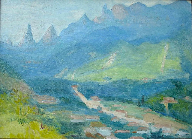
DEDO DE DEUS (2) PAINTED BY ELISEU VISCONTI

ELISEU VISCONTI (1866-1944) Dedo de Deus (1,682m - 5,551ft) Brazil


ELISEU VISCONTI (1866-1944)
Dedo de Deus (1,682m - 5,551ft)
Brazil


About this mainting
Eliseu Visconti painted a lot of times,the Dedo De Deus mountain in the Serra de Orgaos, in any season and in all possible light, at any time of day. It is THE  repetitive motif in his work, a bit like the Montagne Sainte-Victoire for Paul Cézanne or  the volcano Chimborazo for Frederic Edwin Church or Mount Everest for Nicholas Roerich.


The mountain
Dedo de Deus (The Finger of God) (1,682m - 5,551ft) is a peck whose outline resembles a hand pointing the index finger to the sky. It is one of the several geological monuments of Serra dos Órgãos which is located in Serra do Mar, between the cities of Petrópolis, Guapimirim and Teresópolis, in the state of Rio de Janeiro, in Brazil. The mountaineering in Brazil is closely linked to the achievement of the Dedo de deus. The peak is a state symbol Rio de Janeiro, appearing on its flag and coat of arms. As for the coat of arms of the State of Rio de Janeiro, the first section, occupying the upper half, is blue, representing the sky and symbolizing justice, truth and loyalty, with the silhouette of the Serra dos Órgãos, highlighting the Dedo de Deus. The symbol was created by the 1892 State Constitution and made official under the government of José Tomás da Porciúncula, with small differences over time. In 1912, José Guimarães Teixeira, Raul Carneiro and the brothers Américo, Alexandre and Acácio de Oliveira, all from Teresópolis, were the first to step on top of the rock formation.


The artist
Eliseu Visconti, born Eliseo d'Angelo Visconti was an Italian-born Brazilian painter, cartoonist, and teacher. He is considered one of the very few impressionist painters of Brazil. He is considered the initiator of the art nouveau in Brazil.
Thanks to a prize received in 1892, Visconti travelled to Paris, where he attended the École des Beaux Arts the following year. He also took classes at the Académie Julian and the École nationale supérieure des arts décoratifs, where he was a pupil of art nouveau master Eugène Grasset. He was accepted at the Salon de la Nationale des Beaux Arts and at the Salon of the Société of des Artistes Français. As one of the Brazilian representatives to the Exposition Universelle 1900 he exhibited the paintings Gioventú and Oréadas, for which he received a silver medal. Back in Brazil, Visconti exhibited in Rio de Janeiro and São Paulo, and obtained the first place in a contest for the drawing of postal stamps for the Brazilian Casa da Moeda. He traveled again to Europe, where he exhibited at the Paris Salon of 1905 the portrait of the artist Nicolina Vaz de Assis now at the Museu Nacional de Belas Artes. In this same year, he was invited to paint the stage curtain for the Teatro Municipal of Rio de Janeiro which he completed in his studio in Paris.
Decorative schemes executed for the National Library or Biblioteca Nacional in (Rio de Janeiro) date from this period as does another gold medal he received at the International Exhibition of Saint-Louis (Louisiana Purchase Exposition), in 1904, for the painting Recompensa de São Sebastião (see external links). The museum of Santiago of the Chile acquired his Sonho Místico (Mystical Dream) in 1912. In 1913, Visconti returned to Europe in order to paint large scale panels for the "foyer" of the Theatro Municipal do Rio de Janeiro. His plans to return were interrupted by the First World War so he stayed in France until 1920. The resulting paintings for the "foyer" were sent to Brazil during the war, in 1915. In 1922 his triptych "Lar" gained him the Medal of Honor in a large exhibition created in Rio de Janeiro to commemorate the first centennial of Brazilian Independence, the Exposição do Centenário. The following year Visconti painted the mural decoration of Rio de Janeiro's municipal council hall. In 1924, he painted the panel depicting the signature of the first Republican Constitution, for the old federal court, also in Rio de Janeiro.
_______________________________

2022 - Wandering Vertexes...
by Francis Rousseau
Saturday, December 25, 2021

MOUNT SINAÏ/ JABAL MUSA IMAGINED BY FRA ANGELICO


FRA ANGELICO (1395-1455) Mount Sinaï / Jabal Musa (2,285 m - 7,496ft) Egypt  In Fuga in egitto, 1450, toile 38,5x37cm, Museo di San Marco, Firenze,


FRA ANGELICO (1395-1455)
Mount Sinaï / Jabal Musa (2,285 m - 7,496ft)
Egypt

In Fuga in egitto, 1450, toile 38,5x37cm, Museo di San Marco, Firenze, 


The painter
Fra Angelico (born Guido di Pietro) was an Italian painter of the Early Renaissance, described by Vasari in his Lives of the Artists as having "a rare and perfect talent".  He earned his reputation primarily for the series of frescoes he made for his own friary, San Marco, in Florence. He was known to contemporaries as Fra Giovanni da Fiesole (Brother John of Fiesole) and Fra Giovanni Angelico (Angelic Brother John). In modern Italian he is called Beato Angelico (Blessed Angelic One);  the common English name Fra Angelico means the "Angelic friar".
In 1982, Pope John Paul II proclaimed his beatification in recognition of the holiness of his life, thereby making the title of "Blessed" official.  Fiesole is sometimes misinterpreted as being part of his formal name, but it was merely the name of the town where he took his vows as a Dominican friar,  and was used by contemporaries to separate him from others who were also known as Fra Giovanni. He is listed in the Roman Martyrology as Beatus Ioannes Faesulanus, cognomento Angelicus—"Blessed Giovanni of Fiesole, surnamed 'the Angelic' ".
Vasari wrote of Fra Angelico that "it is impossible to bestow too much praise on this holy father, who was so humble and modest in all that he did and said and whose pictures were painted with such facility and piety."
 
The mountain 
Mount Sinaï (2,285 m - 7,496ft) or Jabal Mūsā or Gabal Mūsā (in arab  : "Moses' Mountain" or "Mount Moses"), also known as Mount Horeb or Jebel Musa (a similarly named mountain in Morocco), is a mountain in the Sinai Peninsula of Egypt that is a possible location of the biblical Mount Sinaï. 
The latter is mentioned many times in the Book of Exodus (and other books of the Bible) and in the Quran. According to Jewish, Christian, and Islamic tradition, the biblical Mount Sinai was the place where Moses received the Ten Commandments (depicted in the Jean-Léon Gérôme painting above).
Mount Sinai is a moderately high mountain near the city of Saint Katherine in the Sinai region. It is next to Mount Katherine (2,629m - 8,625 ft), the highest peak in Egypt. 
Mount Sinai's rocks were formed in the late stage of the Arabian-Nubian Shield's (ANS) evolution. Mount Sinai displays a ring complex that consists of alkaline granites intruded into diverse rock types, including volcanics. The granites range in composition from syenogranite to alkali feldspar granite. The volcanic rocks are alkaline to peralkaline and they are represented by subaerial flows and eruptions and subvolcanic porphyry. Generally, the nature of the exposed rocks in Mount Sinai indicates that they originated from differing depths.
There are two principal routes to the summit. The longer and shallower route, Siket El Bashait, takes about 2.5 hours on foot, though camels can be used. The steeper, more direct route (Siket Sayidna Musa) is up the 3,750 "steps of penitence" in the ravine behind the monastery.
The summit of the mountain has a mosque that is still used by Muslims. It also has a Greek Orthodox chapel, constructed in 1934 on the ruins of a 16th-century church, that is not open to the public. The chapel encloses the rock which is considered to be the source for the biblical Tablets of Stone. At the summit also is "Moses' cave", where Moses was said to have waited to receive the Ten Commandments.
___________________________________________

2021 - Wandering Vertexes...
by Francis Rousseau

Thursday, December 16, 2021

DJEBEL AÏSSA BY FREDERIC GADMER / AUTOCHROME LUMIÈRE


FREDERIC GADMER (1878-1954) Djebel Aïssa  (2,236 m  -7,336 ft) Algeria  In Djebel Aïssa, Aïn Sefra, Algérie; Autochrome de Frédéric Gadmer,  1929,

FREDERIC GADMER (1878-1954)
Djebel Aïssa  (2,236 m  -7,336 ft)
Algeria

In Djebel Aïssa, Aïn Sefra, Algérie; Autochrome de Frédéric Gadmer,  1929

The mountain
Mount Issa or Djebel Aïssa (جبل عيسى‎) is a mountain in western Algeria, thus the 4th highest in Algeria. It is part of the Ksour Range of the Saharan Atlas, within the larger Atlas Mountain System. Mount Issa is located in the Naâma Province and is one of the main summits of the mountains of the Saharan Atlas. The Djebel Aissa National Park is a protected area within the area of the mountain since 2003.

The photographer
Frédéric Georges Gadmer was born in 1878 in France into a Protestant family; his father, Leon, son of Swiss émigré, was confectioner. Before World War II, he follows his family in Paris and works as a photographer for the house Vitry, located Quai de la Rapée. As an heliogravure company, it performs work for the sciences and the arts, travel and education. In 1898 Gadmer completed his military service as a secretary to the staff then recalled in 1914 at the time of mobilization. In 1915, he joined the newly created  "Photographic Section of the Army" and carried pictures on the front, in the Dardanelles, with General Gouraud, then in Cameroon. In 1919, at age 41, he was hired as a photographer by Albert Khan for his project called "Archives of the Planet". He finds there his comrades of  "the film and photographic section of the army" Paul Castelnau and Fernand Cuville. Soon as he arrived, he made reports in Syria, Lebanon, Turkey and Palestine. It was the first to make a color portrait of Mustafa Kemal, leader of the Young Turks. In 1921, he returned to the Levant with Jean Brunhes, the scientific director of the Archives of the Planet. The same year, he attended General Gouraud, appointed High Commissioner in Syria. Operator and prolific photographer, specializing in distant lands and landscapes, it covers Iraq, Persia, Afghanistan, Algeria and Tunisia. In 1930, he accompanied Father Francis Aupiais in Dahomey. He also works in Europe. In 1931, at the request of Marechal Lyautey, he photographies the Colonial Exhibition. It is one of the last person to leave the "Archives of the Planet" threatened by the Albert Kahn's bankruptcy in 1932. He then worked at the famous french newspaper L'Illustration and carries postcards for Yvon. He died in Paris, unmarried, in 1954.

About the  "Autochrome Lumière" Photos
The autochrome is a photographic reproduction of process colors patented December 17, 1903 by Auguste and Louis Lumière french brothers. This is the first industrial technique of photography colors, it produces positive images on glass plates. It was used between 1907 and 1932 approximately an particularly in many pictures of the World War I. A important number of photographs of mountains and landscapes around the world was made with this technique, particularly in the for  the Project "The archives of the planet" by Albert Kahn.
_______________________________

2021 - Wandering Vertexes...
by Francis Rousseau

Wednesday, November 24, 2021

BLUE MOUNTAIN PEAK PAINTED BY FREDERIC EDWIN CHURCH


FREDERIC EDWIN CHURCH (1826-1900) Blue Mountain Peak, ( 2256 m - 7402 ft) Jamaica  in Jamaica landscape, West Indies, August 1868, watercolor , Smithsonian/ Cooper Hewitt, Smithsonian Design Museum


FREDERIC EDWIN CHURCH (1826-1900)
Blue Mountain Peak (2,256 m - 7,402 ft)
Jamaica

In Jamaica landscape, West Indies, August 1868, watercolor, Smithsonian/ Cooper Hewitt,  Smithsonian Design Museum

The mountain
Blue Mountain Peak (2,256m - 7401ft) is the highest mountain peak in the Blues mountains, occupying the eastern third of Jamaica. It is also the highest peak in Jamaica.
In May 1655, a British expedition led by Admiral William Penn and General Robert Venables seized the island, still sparsely populated, after having failed to take Santo Domingo. The Spaniards flee after having freed their slaves. Scattered in the jungle, they create dozens of secret villages on the northern slope of the Blue Mountains with its peculiar recrystallized and dolomitic limestone soil, and in the "Cockpit country", pierced by bowl-shaped depressions and watered by heavy rainfall. For a century and a half, these two areas will serve, for their many caches, a rear base with numerous revolts of slaves.
The Jamaica Blue Mountain coffee, which is grown on the mountain slopes of the same name, is one of the most expensive and one of the best in the world.

The painter
Frederic Edwin Church was an American landscape painter born in Hartford, Connecticut. He was a central figure in the Hudson River School of American landscape painters, perhaps best known for painting large panoramic landscapes, often depicting mountains, waterfalls, and sunsets, but also sometimes depicting dramatic natural phenomena that he saw during his travels to the Arctic and Central and South America. Church's paintings put an emphasis on light and a romantic respect for natural detail. In his later years, Church painted classical Mediterranean and Middle Eastern scenes and cityscapes. Church was the product of the second generation of the Hudson River School and the pupil of Thomas Cole, the school’s founder. The Hudson River School was established by the British Thomas Cole when he moved to America and started painting landscapes, mostly of mountains and other traditional American scenes. Both Cole and Church were devout Protestants and the latter's beliefs played a role in his paintings especially his early canvases. Church did differ from Cole in the topics of his paintings: he preferred natural and often majestic scenes over Cole's propensity towards allegory.
Church, like most second generation Hudson River School painters, used extraordinary detail, romanticism, and luminism in his paintings. Romanticism was prominent in Britain and France in the early 1800s as a counter-movement to the Enlightenment virtues of order and logic. Artists of the Romantic period often depicted nature in idealized scenes that depicted the richness and beauty of nature, sometimes also with emphasis on the grand scale of nature.
This tradition carries on in the works of Frederic Church, who idealizes an uninterrupted nature, highlighted by creating excruciatingly detailed art. The emphasis on nature is encouraged by the low horizontal lines, and preponderance of sky to enhance the wilderness; humanity, if it is represented, is depicted as small in comparison with the greater natural reality. The technical skill comes in the form of Luminism, a Hudson River School innovation particularly present in Church's works. Luminism is also cited as encompassing several technical aspects, which can be seen in Church’s works. One example is the attempt to “hide brushstrokes” which makes the scene seem more realistic and lessen the artist’s presence in the work. Most importantly is the emphasis on light (hence luminism) in these scenes. The several sources of light create contrast in the pictures that highlights the beauty and detailed imagery in the painting.

___________________________________________ 


2021 - Wandering Vertexes...
by Francis Rousseau

Wednesday, November 10, 2021

MOUNT SINAÏ -JABAL MUSA PAINTED BY GIOTTO

GIOTTO (1266-1337) Mount Sinaï or Jabal Musa (2,285 m - 7,496ft) Egypt  In The flight into Egypt, fresco, Basilica inferiore di Assisi, 1308-1

GIOTTO (1266-1337)
Mount Sinaï or Jabal Musa (2,285 m - 7,496ft)
Egypt

In The flight into Egypt, fresco, Basilica inferiore di Assisi, 1308-10


About this work
The right transept of the Lower Basilica of Assisi has numerous frescoes by important fourteenth-century authors. On the large barrel vault there are the Stories of Christ's Childhood and the Crucifixion with Franciscan Saints by Giotto and collaborators, dated 1308-1311. The image depicts the scene of the Flight into Egypt already apunted by Giotto few years before in the interior frescoes of the Scrovegni Chapel in Padua, also known as the Arena Chapel. Inetrestirng to have a look at the differencies.

The mountain
Mount Sinaï (2,285 m - 7,496ft) or Jabal Mūsā or Gabal Mūsā (in arab : "Moses' Mountain" or "Mount Moses"), also known as Mount Horeb or Jebel Musa (a similarly named mountain in Morocco), is a mountain in the Sinai Peninsula of Egypt that is a possible location of the biblical Mount Sinaï.
The latter is mentioned many times in the Book of Exodus (and other books of the Bible) and in the Quran. According to Jewish, Christian, and Islamic tradition, the biblical Mount Sinai was the place where Moses received the Ten Commandments (depicted in the Jean-Léon Gérôme painting above).
Mount Sinai is a moderately high mountain near the city of Saint Katherine in the Sinai region. It is next to Mount Katherine (2,629m - 8,625 ft), the highest peak in Egypt.
Mount Sinai's rocks were formed in the late stage of the Arabian-Nubian Shield's (ANS) evolution. Mount Sinai displays a ring complex that consists of alkaline granites intruded into diverse rock types, including volcanics. The granites range in composition from syenogranite to alkali feldspar granite. The volcanic rocks are alkaline to peralkaline and they are represented by subaerial flows and eruptions and subvolcanic porphyry. Generally, the nature of the exposed rocks in Mount Sinai indicates that they originated from differing depths.
There are two principal routes to the summit. The longer and shallower route, Siket El Bashait, takes about 2.5 hours on foot, though camels can be used. The steeper, more direct route (Siket Sayidna Musa) is up the 3,750 "steps of penitence" in the ravine behind the monastery.
The summit of the mountain has a mosque that is still used by Muslims. It also has a Greek Orthodox chapel, constructed in 1934 on the ruins of a 16th-century church, that is not open to the public. The chapel encloses the rock which is considered to be the source for the biblical Tablets of Stone. At the summit also is "Moses' cave", where Moses was said to have waited to receive the Ten Commandments.

The painter
Giotto di Bondone known mononymously as Giotto was an Italian painter and architect from Florence during the Late Middle Ages. He worked during the "Gothic or Proto-Renaissance" period.
Giotto's contemporary, the banker and chronicler Giovanni Villani, wrote that Giotto was "the most sovereign master of painting in his time, who drew all his figures and their postures according to nature" and of his publicly recognized "talent and excellence".
In his Lives of the Most Excellent Painters, Sculptors, and Architects, Giorgio Vasari described Giotto as making a decisive break with the prevalent Byzantine style and as initiating "the great art of painting as we know it today, introducing the technique of drawing accurately from life, which had been neglected for more than two hundred years".
That Giotto painted the Arena Chapel and that he was chosen by the Commune of Florence in 1334 to design the new campanile (bell tower) of the Florence Cathedral are among the few certainties about his life. Almost every other aspect of it is subject to controversy: his birth date, his birth place, his appearance, his apprenticeship, the order in which he created his works, whether or not he painted the famous frescoes in the Upper Basilica of Saint Francis in Assisi and his burial place.

_______________________________

2021 - Wandering Vertexes...
by Francis Rousseau

Wednesday, October 27, 2021

TORRES DEL PAINE (4) PAINTED BY JAMES HART DYKE

JAMES HART DYKE (bn.1966) Torres del Paine (2,500 m - 8,200 ft)  Chile  In Torres del Paine first lights, study 2017, Courtesy John Mitchell Gallery London

 
JAMES HART DYKE (bn.1966)
Torres del Paine (2,500 m - 8,200 ft) 
Chile

In Torres del Paine first lights, study 2017, Courtesy John Mitchell Gallery London  


The mountains
The Torres del Paine (2,500 metres - 8,200 ft) are the distinctive three granite peaks of the Paine mountain range or Paine Massif. They are known as Torres d'Agostini, Torres Central and Torres Monzino. They are joined by the Cuernos del Paine. The area also boasts valleys, rivers such as the Paine, lakes, and glaciers. The well-known lakes include Grey, Pehoé, Nordenskiöld, and Sarmiento. The glaciers, including Grey, Pingo and Tyndall, belong to the Southern Patagonia Ice Field.
he landscape of the park is dominated by the Paine massif, which is an eastern spur of the Andes located on the east side of the Grey Glacier, rising dramatically above the Patagonian steppe. Small valleys separate the spectacular granite spires and mountains of the massif. These are: Valle del Francés (French Valley), Valle Bader, Valle Ascencio, and Valle del Silencio (Silence Valley).The Southern Patagonian Ice Field mantles a great portion of the park.


The painter
James Hart Dyke’s work is centred on landscape painting, from the domesticity of paintings of country houses to paintings generated from physically demanding expeditions over remote mountains. James has also undertaken a series of projects including accompanying HRH The Prince of Wales as the official artist on royal tours, working as ‘artist in residence’ for The British Secret Intelligence Service, working as an artist embedded with the British Forces in war zones, working for the producers of the James Bond films and working as ‘artist in residence’ for Aston Martin. These projects required him to respond in many different ways and have allowed him to experiment with more graphic forms of painting influenced by his studies as an architect at the Royal College of Art. His portraits have been shown at the National Portrait Gallery and at the Royal Society of Portrait Painters exhibitions.

___________________________


2020 - Wandering Vertexes
Un blog de Francis Rousseau

Monday, October 18, 2021

PIZ BALZET, PUNTA DE L'ALBIGNA, SPAZZACALDEIRA BY GIOVANNI GIACOMETTI

GIOVANNI GIACOMETTI (1868-1933), Piz Balzet (2, 869 m - 9,413 ft), Punta de l'Albigna (2,825 m - 9,268 ft), Spazzacaldeira (2,487 m- 8,159 ft) ,Switzerland  In  Albigna Valley, oil on canvas, 1932

GIOVANNI GIACOMETTI (1868-1933)
Piz Balzet (2, 869 m - 9,413 ft)
Punta de l'Albigna (2,825 m - 9,268 ft)
Spazzacaldeira (2,487 m- 8,159 ft)
Switzerland
 In  Albigna Valley, oil on canvas,  1932

The Mountains 

The Piz Balzet  (2, 869 m - 9,413 ft)  is a  tall granite mountain located in Bergell, Switzerland. Standing just on the eastern edge of the Albigna reservoir it is clearly visible when driving down from the Maloja-pass to the north and from the campsite at Vicosoprano. Seen from this (its western) side the Balzet is an imposing picture; very steep slabs fall off into the valley and several ridges make their way to the well defined summit. A different picture entirely is presented when the mountain is viewed from its southern side; from this side there are no steep drops to valley floors far below. Instead, it is 'merely' a summit in the ridge leading up to the Piz Bacun (3,244m).
The Punta da l'Albigna  (2,825 m - 9,268 ft) is an easily recognizable summit on the eastern side of the Albigna lake in the Bergell, an area in south-eastern Switzerland famous for its multitude of alpine rock climbs on excellent granite. Along with the Spazzacaldeira and the Piz Balzet, the Punta da l'Albigna ranks among the most popular climbing hotspots in the Albigna area. It hosts numerous routes from 4a to 5c and varying in length between 8 and 12 ropelengths. Most of the routes are bolted, though some rather sparingly
Spazzacaldeira (2,487 m- 8,159 ft) is the name of the ridge directly west of the Albigna reservoir, just to the north of the Al Gal. It offers a multitude of alpine-sport routes across its eastern face and the north-east ridge is a well known classic in the area. Because of the generally well bolted nature of the routes and the incredibly easy access via the nearby cable car station, Spazzacaldeira can attract a large number of climbers. Most of them will be aiming for the summit pinnacle, the famous Fiamma, a striking summit spire seen on many local postcards.

The painter
Giovanni Giacometti was a Swiss painter, the father of the famous painter and sculptor Alberto Giacometti, and of Diego Giacometti, the furniture designer as well as the father of the architect Bruno Giacometti ! In 1886, he studied painting at the School of Decorative Arts in Munich, where he met Cuno Amiet the following year. Both decide to pursue their studies in Paris, in October stood at the Académie Julian, where Giacometti remains until 1891.
In 1893, shortly after his return to Switzerland, to Bergell, he became friends with Giovanni Segantini, his eldest ten years, which has great influence on his work by opening it to the beauty of the mountain scenery and the rules of divisionism. After his sudden death in 1899, Giacometti met Ferdinand Hodler, who teaches him to create a rigorous and ornamental composition by appropriate use of shapes and colors.
He sees regularly Cuno Amiet, who after a year spent in Pont-Aven, shared his experience with him. In 1900 he exhibited in the Swiss Pavillon of the Universal Exhibition in Paris. From 1905, Giacometti works again in a great complicity with Amiet and begins to break free from the influence of Segantini. In 1906, held an exhibition of his work at Kunstlerhaus Zurich. In 1907 he went to Paris with Amiet to the Cézanne retrospective at the Salon d'Automne. They copy all the works of Van Gogh. In 1908, he exhibited with the French Fauves at the Richter Gallery in Dresden.
In 1909, the Tannhauser Gallery presents his works in Munich. He meets Alexi von Jawlensky, and in 1911 participates in the Berlin Secession. In 1912, Giacometti has a solo show at the Kunsthaus Zurich presents two works in the Sonderbund of Cologne. In 1918 after Hodler' s death, he began to be involved into the Swiss political world paying an important part as a committed artist, following int that way friend Amiet.

___________________________
2021 - Wandering Vertexes...
by Francis Rousseau


Sunday, October 3, 2021

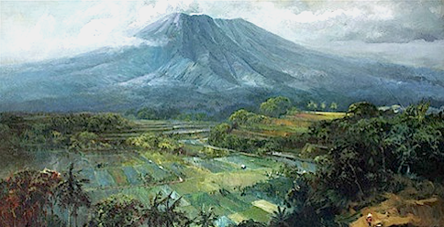
GUNUNG BROMO PAINTED BY SUDJONO ABDULLAH


SUDJONO ABDULLAH (1911-1993) Gunung Bromo (2,329m - 7,641ft) Indonesia (Java Timur)  In Gunung Bromo, 1960, oil on canvas,Ptviatre collection


SUDJONO ABDULLAH (1911-1993)
Gunung Bromo (2,329m - 7,641ft)
Indonesia (Java Timur)

In Gunung Bromo, 1960, oil on canvas, Private collection


The volcano
Gunung Bromo (2,329m - 7,641ft) or Gunung Brama, an active volcano,in East Java, Indonesia, is not the highest peak of the Tengger massif, but the best known. The massif area is one of the most visited tourist attractions in East Java, Indonesia. The volcano belongs to the Bromo Tengger Semeru National Park. The name of Bromo derived from Javanese pronunciation of Brahma, the Hindu creator god. Gunung Bromo sits in the middle of a plain called the "Sea of Sand"  a protected nature reserve since 1919. The best way to visit Gunung Bromo is from the nearby mountain village of Cemoro Lawang, from where it is possible to walk during 45 mn to the volcano. It is also possible to take an organised jeep tour, which includes a stop at the viewpoint on Gunung Penanjakan (2,770 m - 9,088 ft).

On the fourteenth day of the Hindu festival of Yadnya Kasada, the Tenggerese people of Probolinggo, East Java, travel up the mountain in order to make offerings of fruit, rice, vegetables, flowers and sacrifices to the mountain gods by throwing it into the caldera of the volcano. The origin of the ritual lies in the 15th century legend when princess  Roro Anteng started the principality of Tengger with her husband, Joko Seger. The couple were childless and therefore beseeched the assistance of the mountain gods. The gods granted them 24 children but stipulated that the 25th child, named Kesuma, must be thrown into the volcano as a human sacrifice. The gods' request was implemented. The tradition of throwing sacrifices into the volcano to appease these ancient deities continues today and is called the Yadnya Kasada ceremony. Though fraught with danger, some locals risk climbing down into the crater in an attempt to recollect the sacrificed goods that they believe could bring them good luck.
Depending on the degree of volcanic activity, the Indonesian Centre for Volcanology and Disaster Hazard Mitigation sometimes issues warnings against visiting Mount Bromo.
 Mount Bromo recently erupted in 2004, 2010, 2011 and 2015.


The painter
Raden Soedjono Abdullah was born in Yogyakarta, the son of Abdullah Suriosubroto, a famous landscape painter and was also the brother of Basoeki Abdullah. He used to help his father cleaning the pallet from which he found his way to be a painter. He finished his school from HIS Indonesian Dutch School and worked as a poster artist for the Rex Theater in Yogyakarta. During the Japanese colonization in Indonesia, Sudjono went to Parangtritis, Parangkusumo where he continued to paint. During the 1970s, Soedjono moved to Kertosono in East Java, where he lived up to his death.

___________________________________________

2021 - Wandering Vertexes...
by Francis Rousseau

Monday, September 27, 2021

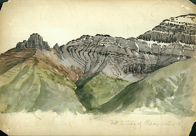
CLYDE PEAK PAINTED BY ARTHUR P. COLEMAN


ARTHUR P. COLEMAN (1852-1939), Clyde Peak (2,624 m - 8,610 f) United States of America (Montana)  In Mountain South Clide, watercolor on paper, 1895 A.P Coleman Funds.


ARTHUR P. COLEMAN (1852-1939)
Clyde Peak (2,624 m - 8,610 ft)
United States of America (Montana)

In Mountain South Clide, watercolor on paper, 1895 A.P Coleman Funds.


The mountain
Clyde Peak 2,624 m- is an 8,610 ft) is  located in Glacier National Park in the U.S. state of Montana. The mountain straddles the border shared by Flathead County and Glacier County. It is situated on the Continental Divide so precipitation runoff from the west side of the mountain drains into Thompson Creek which is part of the Middle Fork Flathead Riverwatershed, and the east side drains into headwaters of Red Eagle Creek, which flows to Red Eagle Lake, thence Saint Mary Lake. It is set in the Lewis Range, and the nearest higher neighbor is Mount Logan 1.44 mile to the northwest. Topographic relief is significant as the southwest aspect rises approximately 4,000 feet (1,220 meters) in one mile.
The mountain's name commemorates Norman Clyde (1885–1972), who made the first ascent of this peak on July 23, 1923.  Clyde is credited with 130 first ascents, most of which were in the Sierra Nevada of California.[ In 1923 he spent 36 days in Glacier National Park, Montana, where he climbed 36 mountains, including 11 first ascents.


The painter
Arthur Philemon Coleman was a Canadian a geologist, professor, minerals prospector, artist, Rockies explorer, backwoods canoeist, world traveller, scientist, popular lecturer, museum administrator, memoirist and... one of Canada’s most beloved scientist.
Arthur Coleman is a fine example of that rare bird, a polished amateur artist whose drawings and paintings stand comfortably beside those of many professionals. He was active during the time when sketching and painting was ceding to photography the task of recording the visible world. Although he was also a photographer, painting was, for him, both a poetic and a descriptive pursuit, a way of wrapping an artistic expression around a phenomenon he was interested in or moved by. Thus motivated, Coleman's paintings give much joy and command a good deal of respect. The more surprising, perhaps given that he used to introduced himself more as a geologist than a painter.
Coleman travelled throughout the United States for professional conferences as well as geological field work. He visited many of the major American mountain ranges including: the American Cordillera Mountains (Washington, Oregon and California); the Sierra Nevada Mountains (California and Nevada); Yellowstone National Park (Wyoming, Montana and Idaho); and the Appalachian Mountains (eastern United States). Pleistocene glaciation had extended in Northern Europe as far south as Berlin and London and covered an area of two million square miles. Coleman also visited such countries as India, Australia, Brazil, Argentina, Scandinavia, Bolivia, New Zealand, South Africa and Uruguay. In his final years he made two expeditions to the Andes in Colombia, to mountains in Southern Mexico and to two mountains in Central America. He achieved the first ascent of Castle Mountain in 1884, and in 1907, he was the first white man to attempt to climb Mount Robson. He made a total of eight exploratory trips to the Canadian Rockies, wholly four of them looking for the mythical giants of Hooker and Brown.
From 1901 to 1922, he was a Professor of Geology at the University of Toronto and was Dean of the Faculty of Arts from 1919 to 1922. From 1931 to 1934, he was a geologist with the Department of Mines of the Government of Ontario. He was elected a Fellow of the Royal Society of Canada in 1900 and was its President in 1921. In 1929, he was appointed Honorary Vice-President of the Royal Canadian Geographical Society.
"Mount Coleman" and "Coleman Glacier" in Banff National Park is named in his honor. He was awarded the Penrose Medal in 1936.
He planned to climb "his" mountain, "Mount Coleman"'in the Albertan Rockies, and had also prepared a trip to British Guiana, but death intervened.
He was author of:
- Reports on the Economic Geology of Ontario (1903)
- Lake Ojibway; Last of the Great Glacial Lakes (1909)
- The Canadian Rockies: New and Old Trails (1911)
- Ice Ages, Recent and Ancient (1926), and was co-author of Elementary Geology (1922).
- The Last Million Years (1941) edited by George F. Kay

 
___________________________________________
2021 - Wandering Vertexes...
by Francis Rousseau
Saturday, September 25, 2021

MONTE ROTONDO (CORSICA) SKETCHED BY JOHN MINTON

John Minton (1917-1957) Monte Rotondo (2,622 m -8,602 ft) France (Corse)  In Corte, Corsica, ink on paper,  1947, 40 x 24,3cm, Tate 
 
John Minton (1917-1957)
Monte Rotondo (2,622 m -8,602 ft)
France (Corse)

In Corte, Corsica, ink on paper,  1947, 40 x 24,3cm, Tate


About this work 
Minton visited Corsica in the late summer of 1947 with Alan Ross in connexion with their book Time was away, published by John Lehmann the following year; Minton did the illustrations, Ross the text. A group of Minton's drawings of views in Corsica was exhibited at the Lefevre Gallery in February 1949.

The mountain
Monte Rotondo (2,622 m - 8, 602 ft) visible from the town of Corte , Corsica (France) is the highest point of the second highest massif in the island ahead of those of Monte Renoso and Monte Incudine. It is located in the center of the island between the pits of Talcini, Venaco, Rogna and Sorroinsù. The summit overlooks, among others, Lake Bettaniella (on the south face), Lake Oriente and Lake Galiera (on the north face). Its main peaks are Monte Rotondo, Maniccia, Monte Cardo, Monte d'Oro, Punta Artica and Punta alle Porte.
l has long been considered the highest point on the island and was assigned an altitude of 2,746 meters. It has only been dethroned on the shelves by Monte Cinto for about a century. In 1802, André François Miot, Councilor of State appointed in Corsica by Bonaparte was the first to make the “tourist” ascent to the summit. With two other Corsican peaks, Monte Cinto and Monte Stello, Monte Rotondo served at the geodesic junction between Corsica and mainland France made by Paul Helbronner in 1925. The establishment of facilities such as the shelter have allowed the summit to be occupied for 14 days.

The artist
Francis John Minton was an English painter, illustrator, stage designer and teacher. After studying in France, he became a teacher in London, and at the same time maintained a consistently large output of works. In addition to landscapes, portraits and other paintings, some of them on an unusually large scale, he built up a reputation as an illustrator of books. In the mid-1950s, Minton found himself out of sympathy with the abstract trend that was then becoming fashionable, and felt increasingly sidelined. He suffered psychological problems, self-medicated with alcohol, and in 1957 died by suicide. In the Oxford Dictionary of National Biography's entry on Minton, Michael Middleton writes:
"Minton is often seen as an illustrator rather than a painter. He certainly extended and enriched the English graphic tradition. In all his varied output, however, may be sensed an elegiac awareness of the evanescence of physical beauty that is entirely personal. His work is to be found in the Tate collection, and many public and private collections at home and abroad. A retrospective exhibition of 1994, curated by his biographer, Frances Spalding, provided a convincing reminder of the range of his gifts. For the historian he must remain a potent symbol of his period."

 
___________________________________________
2021 - Wandering Vertexes...
by Francis Rousseau

Friday, September 10, 2021

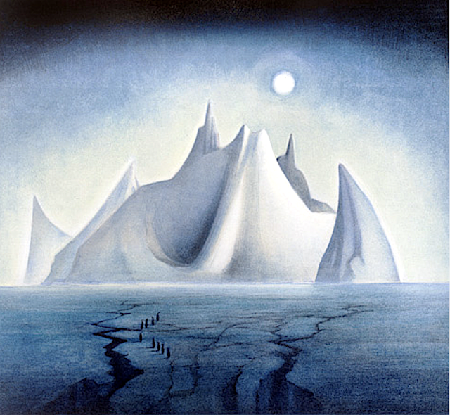
TROLLSLOTTET MOUNTAIN PAINTED BY VEJBJØRN SAND


VEJBJØRN SAND (bn. 1966), Trollslottet mountain (2,737 m- 8,930 ft) Antarctica,   In  Trollslottet, 1997, Antarctica


VEJBJØRN SAND (bn. 1966)
Trollslottet mountain (2,737 m- 8,930 ft)
Antarctica

In Trollslottet, 1997, Antarctica  


About this Painting
After an expedition to Antarctica, Queen Maud Land (Independent Norwegian territory in Antarctica) , Vebjørn completed his first public work, The Troll Castle (Trollslottet) which was inspired by the voyage. In collaboration with the team who arranged the opening of the Winter Olympics at Lillehammer in 1994, Vebjørn constructed a “Mini Antarctica” formed by 10 towers surrounding a circle, all reminiscent of Arnesteinen, a mountain shooting out of the ice in the shape of a cathedral. Inside the castle Vebjørn included paintings (as the one above) conceived and executed in Antarctica, stored inside glass boxes to resemble ice. The castle was designed so that visitors could walk inside the space and experience a frigid atmosphere similar to the one Vebjørn did when he painted them. During the first 3 months of its opening in the winter of 1997/98, 180,000 people visited the Troll Castle.


The mountain
Trollslottet Mountain (2,737m - 8,930ft) situated at 71°56′S 7°14′E, is a high ridgelike mountain with several prominent peaks  forming the northwest limit of the Filchner Mountains in Queen Maud Land (Independant Norwegian territory in Antarctica). Plotted from surveys and air photos by Norwegian Antarctic Expedition (1956–60) and named Trollslottet (the troll castle). The Filchner Mountains are a group of mountains 11 km (7 mi) southwest of the Drygalski Mountains, at the western end of the Orvin Mountains of Queen Maud Land, Antarctica. They were discovered by the Third German Antarctic Expedition (1938–1939), led by Capt. Alfred Ritscher, and named for Wilhelm Filchner, leader of the German expedition to the Weddell Sea area in 1911–12. They were remapped from air photos taken by the Sixth Norwegian Antarctic Expedition, 1958–59

The Painter
Vebjørn Sand (born March 11, 1966) is a Norwegian painter and artist. He is known for his paintings as well as his public arts projects, such as the Da Vinci Project, and the Kepler Star monument (Norwegian Peace Star) at Oslo Airport, Gardermoen.
Building off the original Da Vinci bridge in Norway, Vebjørn used Leonardo's philosophy of encompassing all fields of research to use the project to discuss global warming. First he used ice to reinterpret and construct a new bridge during his expedition to Queen Maud Land in Antarctica. After that, in December of 2007, Vebjørn erected a temporary ice bridge to dramatize the melting glaciers of Antarctica due to climate change outside of the United Nations Plaza in New York. During the unveiling at the U.N. Headquarters, Vebjørn said of the bridge in Antarctica,
“Our future lays underneath that ice glacier. So to erect it on that glacier, and that part of Antarctica, (it) must never melt. The one outside the United Nations is intended to melt to show that Antarctica is melting.”
The bridge was unveiled earlier that year two days after nearly 200 nations agreed at the U.N.-led talks in Bali to launch negotiations on a new pact to fight global warming.
In 2009, Vebjørn built another ice bridge in Ilulissat, Greenland (where most icebergs are borne into the sea). Later that year in Copenhagen, as part of the United Nations Climate Change Conference, also known as COP15, Vebjørn constructed yet another ice bridge in front of the Danish Parliament to raise global awareness of climate change.


___________________________________________


2021 - Wandering Vertexes...

by Francis Rousseau 


Wednesday, August 25, 2021

PICURIS MOUNTAINS PAINTED BY VICTOR HIGGINS


VICTOR HIGGINS ( 1884-1949)   Picuris Mountains (2,967 m -  9,734 feet)  United States of America (New Mexico)    In Taos Mountain, ca. 1940, oil on canvas,
 
VICTOR HIGGINS ( 1884-1949)
Picuris Mountains (2,967 m - 9,734 ft)
United States of America (New Mexico)

In Taos Mountain, ca. 1940, oil on canvas, Private collection 


The mountains
Picuris Mountains (2,967 m - 9,734 feet) is one of the Ridge in Taos County, nearby Osha Canyon and Vallecitos. Named Pikuria – those who paint – by Spanish colonizer Juan de Oñate, Picuris is located 24 miles (38 km) southeast of Taos in the Sangre de Cristo Mountains via N.M. 68, 518, and 75. Picuris, once the largest, today is one of the smallest Tiwa pueblos, with some 1,801 inhabitants (Census 2000). Like Taos, it was influenced by Plains Indian culture, particularly the Apaches
If one like biking, the ride takes you into the scenic and historic part of Picuris Mountains. About 2 miles from the start of this ride you will cross the historic Camino Real, or “Royal Highway,” that served as the original highway to Taos for traders, settlers, and Native Americans traveling north and south for several hundred years.
In late spring through fall this ride is free of snow and dry. It can be pretty beastly pushing up this mountain in the middle of summer. Plan on riding early or late in the day to avoid the heat.

The artist
William Victor Higgins was an American painter and teacher, born at Shelbyville, Indiana. He studied at the Art Institute in Chicago and at the Chicago Academy of Fine Arts.
In Paris he was a pupil of Robert Henri, René Menard and Lucien Simon, and when he was in Munich he studied with Hans von Hayek. He was an associate of the National Academy of Design. Higgins moved to Taos, New Mexico in 1913 and joined in 1917 the Taos Society of Artists founded two years before by Joseph Henry Sharp, W. Herbert Dunton, Eanger Irving Couse et Oscar Edmund Berninghaus.
In 1923 he founded The Hartwood Foundation with Louise Harwood and Bert Phillips. He then painted a lot of works representing the mountains range surrounding the city of Taos and especially the Pueblo Mountains.
During the Depression, he was commissioned to paint a mural inside the Taos County Courthouse financed by the PWAP, titled Moises, El Legislador.

_______________________________

2021 - Wandering Vertexes 
A blog by Francis Rousseau

Sunday, June 20, 2021

TORRES DEL PAINE (2) PAINTED BY JAMES HART DYKE


JAMES HART DYKE (bn.1966) Torres del Paine (2,500 m - 8,200 ft) Chile  In Los Cuernos del Paine last light, oil on vanvas 2018, courtesy John Mitchell Gallery
 
JAMES HART DYKE (bn.1966)
Torres del Paine (2,500 m - 8,200 ft)
Chile

In Los Cuernos del Paine last light, oil on vanvas 2018, courtesy John Mitchell Gallery 


The mountains
The Torres del Paine (2,500 metres - 8,200 ft) are the distinctive three granite peaks of the Paine mountain range or Paine Massif. They are known as Torres d'Agostini, Torres Central and Torres Monzino. They are joined by the Cuernos del Paine. The area also boasts valleys, rivers such as the Paine, lakes, and glaciers. The well-known lakes include Grey, Pehoé, Nordenskiöld, and Sarmiento. The glaciers, including Grey, Pingo and Tyndall, belong to the Southern Patagonia Ice Field.
he landscape of the park is dominated by the Paine massif, which is an eastern spur of the Andes located on the east side of the Grey Glacier, rising dramatically above the Patagonian steppe. Small valleys separate the spectacular granite spires and mountains of the massif. These are: Valle del Francés (French Valley), Valle Bader, Valle Ascencio, and Valle del Silencio (Silence Valley).
The Southern Patagonian Ice Field mantles a great portion of the park.

The painter
James Hart Dyke’s work is centred on landscape painting, from the domesticity of paintings of country houses to paintings generated from physically demanding expeditions over remote mountains. James has also undertaken a series of projects including accompanying HRH The Prince of Wales as the official artist on royal tours, working as ‘artist in residence’ for The British Secret Intelligence Service, working as an artist embedded with the British Forces in war zones, working for the producers of the James Bond films and working as ‘artist in residence’ for Aston Martin. These projects required him to respond in many different ways and have allowed him to experiment with more graphic forms of painting influenced by his studies as an architect at the Royal College of Art. His portraits have been shown at the National Portrait Gallery and at the Royal Society of Portrait Painters exhibitions.

___________________________________________
2021 - Wandering Vertexes and Mountain paintings
Un blog de Francis Rousseau

Saturday, June 12, 2021

OPALA VOLCANO BY STEPAN KRASCHENINNIKOW


STEPAN  KRASCHENINNIKOW (1711-1755) Opala volcano (2,475m-8100 ft) Russia (Kamchatka)   In Mountains of Kamtschatka, St Petersbourg 1755


STEPAN  KRASCHENINNIKOW (1711-1755)
Opala volcano (2,475m-8100 ft)
Russia (Kamchatka)

 In Mountains of Kamtschatka, St Petersbourg 1755

The volcano
Opala (Опала)  (2,475m-8100 ft)  is a large stratovolcano located in South Kamchatka about 50 km west of the Eastern volcanic front.  The volcano sits on the northern rim of a 14x12 km large Late Pleistocene caldera. The summit of the volcano has a nice small crater. The most prominent feature at the foot of the volcano is Baranii Amphitheater - a large Novarupta-type crater filled with extrusive domes. This crater formed about 1500 years BP and produced 9-10 km3 of rhyolitic pumice that is about 4.5 km3 of magma. Later the crater was filled with extrusive domes. There was at least one later eruption within the crater, which formed explosive craters on the surface of the extrusive domes and produced minor pumiceous tephra.  Several hazy reports of Opala's historical eruptions were known, but no real evidence of recent eruptions had been found at the slopes of the volcano.  However,  later studies have allowed to document a significant explosive eruption from the summit crater, which occurred as recently as about 300 years ago and produced rhyolitic tephra (informally known as "Ghost layer"). Earlier eruptions from Opala produced lava flows and pumiceous tephra.  The eruption from Baranii  Amphitheater was one of the most voluminous explosive eruptions in Kamchatka during the Holocene.  Opala is undoubtedly an active volcano posing a serious hazard to the region.  Recent eruptions from Opala produced dominantly rhyolitic material that indicates a presence of living silicic chamber under the volcano. Holocene products of Opala volcano are high potassic andesites-rhyolites. Baranii Amphitheater crater produced uniform rhyolites without any admixture of more mafic varieties.  Opala volcano has been producing andesitic-dacitic lavas and tephras for most of Holocene; the last significant eruption of this kind was ab. 3500 14C yrs BP.  How was it possible to produce, accumulate, store and finally erupt - just in a couple of millenia - about 4.3 km3 of rhyolitic magma from the crater located on the volcano's slope, a mere 5 km from its summit? Was the OP eruptionit a part of the Opala volcano story or any special event? Why is this magma so similar to Chasha crater's one, stored 15 km away? These are genral questions to this volcano.

The artist 
Stepan Petrovich Krasheninnikov (Степа́н Петро́вич Крашени́нников) was a Russian explorer of Siberia, naturalist and geographer who gave the first full description of Kamchatka in the early 18th century. He was elected to the Russian Academy of Sciences in 1745. The Krasheninnikov Volcano on Kamchatka is named in his honour. He embarked upon the Second Kamchatka Expedition (1731–42). Krasheninnikov was to study plants, animals and minerals, but in addition he developed a strong interest in Siberian history and geography. During the early part of the expedition, he accompanied professor Gmelin on the travel through the Urals and western Siberia to Yeniseysk. He made numerous observations of natural history, ethnology and linguistics, e.g. records of Evenki (tungus) and Buryat vocabulary. From Bering’s headquarters at Yakutsk, the expedition professors Gmelin and Gerhard Friedrich Müller sent Krasheninnikov ahead to Okhotsk and Kamchatka to build house and make preliminary observations. Thus, he became the member of the expedition with the most extensive knowledge of the peninsula. He published his observations in 1755 (Описание земли Камчатки); English translation by James Grieve (1764) as History of Kamtschatka. However, he drew extensively on the manuscripts of the deceased Georg Wilhelm Steller. Apart from detailed accounts of the plants and animals of the region, there also were reports on the language and culture of the indigenous Itelmen and Koryak peoples, with whom he is said to have got along extremely well. Krasheninnikov spent ten years on the Second Kamchatka Expedition. On his return to St Petersburg, he wrote and defended his doctoral thesis on ichthyology in 1745. He was appointed adjunct at the Academy of Sciences, and later head of the Academy's Botanic Garden and professor of natural history at the university. He was one of only 26 Russians to become Academy members in the 18th century. In 1752, Krasheninnikov went on his last expedition to the tracts of Lake Ladoga and Novgorod to investigate the flora. He died before being able to publish his observations, which instead were published by David de Gorter.

Saturday, June 5, 2021

ADRAR SAGRO PAINTED BY PAUL-JEAN FLANDRIN

PAUL-JEAN FLANDRIN (1811-1902) Adrar Sagro  (2,712m - 8,897ft) Morocco    In   "Les Gorges de l'Atlas, " 1843, oil on canvas, 1843, Private collection


PAUL-JEAN FLANDRIN (1811-1902)
Adrar Sagro  (2,712m - 8,897ft)
Morocco 

 In   "Les Gorges de l'Atlas, " 1843, oil on canvas, 1843, Private collection


The mountain
Adrar Saghro or Jebel Saghro (2,712m - 8,897ft) is a mountain in southern Morocco, located east of Ouarzazate, 70 km south of the central High Atlas, dominating the Drâa valleys to the west and south, and that of Dades to the north. It constitutes the eastern part of the Anti-Atlas. Jebel Saghro is the driest area of the Anti-Atlas range. Unlike the areas located further west, it does not benefit from a high enough air humidity due to the remoteness of the Atlantic Ocean. Annual precipitation does not exceed 100 mm in the south and 300 mm on the summits. Jebel Saghro is oriented along a southwest / northeast axis, and extends towards Jebel Ougnat east of Wadi Alnif and the Tizi n'Boujou pass. It borders the Dades valley and the High Atlas to the north and links the Drâa valley to the south. Lunar landscape of plateaus, peaks, canyons crossed by wadis, forests, all dominated by basalt peaks. Oleanders, junipers, mountain flowers ... occupy the valley bottoms. The north-south crossings are made by three passes crossed by difficult and very spectacular tracks: the Tazazert pass (2,283 m), the Kouaouch pass (2,592 m), and the Tagmout pass (1,919 m). The highest point of the mountain is Amalou n Mansour (2,712 m) which is located to the south-east of the village of Iknioun.
Charles de Foucauld, still only in search of adventure, is one of the first Western travelers to have described his crossing of Jebel Saghro (Reconnaissance au Maroc published in 1888 in Paris). It completes its description with a topographic survey. Jebel Saghro was also later the setting for fierce fighting linked to the progression of the French army within the framework of the protectorate, the battle of Bougafer (February-March 1933), in which the French troops allied to those of the Sultan of Morocco faced an impressive and heroic resistance from the Aït Atta tribes led by Sheikh Assou Oubasslam. It is in this massif that the famous captain Henry de Bournazel, one of the protagonists of this war, was killed in the fight against the Berbers, while assaulting the rocky dome.

 
The painter
Paul-Jean Flandrin is a French painter, younger brother of the painters Auguste Flandrin and Hippolyte Flandrin. he first received advice from the landscape and animal painter Antoine Duclaux, as well as from the sculptor Jean-François Legendre-Héral, before joining the École des beaux-arts de Lyon, then that of Paris and the workshop by Jean-Auguste-Dominique Ingres.
He failed twice in the Prix de Rome competition but nevertheless joined at his own expense his brother Hippolyte in Italy. They stayed in Rome for four years, during which Paul specialized in landscape painting. He carried out studies from nature which he used to undertake historical compositions which he presented at the Parisian Salons. He also regularly collaborates on the landscapes of his older brother's paintings. Flandrin continued until late in the nineteenth century this tradition of classical landscape of which he was one of the best representatives, alongside Édouard Bertin or his father-in-law Alexandre Desgoffe. He combines this with a sense of line and ideal inherited from the lessons of his master Ingres. Charles Baudelaire thus accuses him of wanting to “Ingriser” (painted like Ingres) the landscape, a criticism that will long be associated with it. 

______________________

2021 - Wandering Vertexes...
by Francis Rousseau
Wednesday, May 12, 2021

VOLCAN PUNTIAGUDO PHOTOGRAPHED IN 1932 BY ROBERT GERSTMANN

ROBERT GERSTMANN (1896-1960) Volcàn Puntiagudo (2, 493 m - 8, 179ft) Chile  In Volcàn Puntiagudo, photograph,1932, Photographer

ROBERT GERSTMANN (1896-1960)
Volcàn Puntiagudo (2, 493 m - 8, 179ft)
Chile

In Volcàn Puntiagudo, photograph,1932, Private collection


The volcano
Volcàn Puntiagudo (2, 493 m - 8, 179ft) also called Cerro Cenizas or Cerro Puntiagudo is a volcano in Chile remarkable for its volcanic chimney released by erosion and forming a summit neck. Puntiagudo is located in central Chile, in the Andes mountain range, between the Rupanco lakes to the north and Todos Los Santos to the south. Administratively, it is located on the border between the provinces of Llanquihue and Osorno of the Region of Lakes. Puntiagudo is an andesitic stratovolcano whose flanks have been eroded by glaciers, especially in their upper par1. Its summit is thus made up of a neck by the release of the volcanic chimney. This physiognomy makes it resemble Corcovado, another Chilean volcano located further south. Cordón Cenizos is a group of fissures and volcanic cones, stretches from Puntiagudo to the northeast. Puntiagudo began to be built at the end of the Pleistocene. However, its last eruption occurred on an unknown date.


The photographer
Robert Gerstmann was a photographer very famous in South America. Gerstmann was a Vienna born electrical engineer who, as a young man, developed an interest in photography. In 1924, he immigrated to Chile and from there traveled to Bolivia, where he made some 5000 photographs, a selection of which appear as photogravures in his Bolivia, 150 Grabados en Cobre (1928), which was reissued in 1996 by the Fundación Quipus in La Paz. Gerstmann ranged far, photographing the altiplano from La Paz south to the Argentine border, west to the Chilean border, and east to the Yungas, Cochabamba, Santa Cruz, and the lowlands along the Ríos Beni and Mamoré. Only Tarija and the Chaco escaped his lens. Five of his photographs illustrate Stewart E. McMillan's "The Heart of Aymara Land" National Geographic Magazine (February 1927), and several appear in Gustavo-Adolfo Otero's Bolivia (Guía Sinóptica) 1929. Gerstmann settled in Santiago in 1929. He published other photo albums, including Chile: 280 grabados en cobre (1932), Colombia: 200 grabados en cobre (1951), and Chile en 110 cuadros (1960?), and dabbled in film-making in Bolivia. He is thought to have died in Santiago ca. 1960. Several thousand of his glass plates are said to be at a university in Antofagasta.

_______________________________
2021 - Wandering Vertexes...
by Francis Rousseau

Wednesday, April 28, 2021

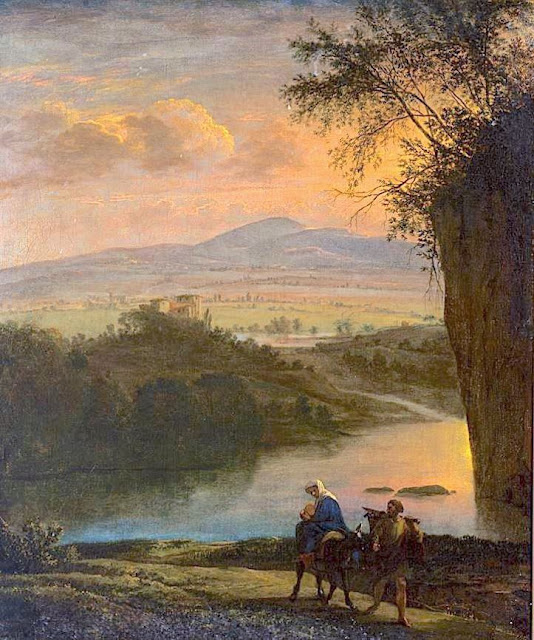
MOUNT SINAI / JABAL MUSA PAINTED BY JAN ASSELIJN

Jan Asselijn (c.1610 – October 1, 1652) Mount Sinaï / Jabal Musa (2,285 m - 7,496ft) Egypt In Flight into Egypt, c. 1640, oil on canvas, Rijksmuseum, Amsterdam


Jan Asselijn (c.1610 – October 1, 1652)
Mount Sinaï / Jabal Musa (2,285 m - 7,496ft)
Egypt

In Flight into Egypt, c. 1640, oil on canvas, Rijksmuseum, Amsterdam

 
About the painting 
Flight into Egypt used to be a very popular subject. Hundreds of canvas were painted on this subject between the 14th and 19th centuries, showing Mary with the baby on a donkey, led by Joseph, borrowing older iconography from the rare Byzantine journey to Bethlehem. Nevertheless, Joseph sometimes holds the child on his shoulders. Prior to about 1525, it was generally part of a larger cycle, whether it was the Nativity, the Life of Christ, or the Life of the Virgin. The background of these scenes generally (until the Council of Trent tightened up on such additions to the Scriptures) included a number of apocryphal miracles and provided an opportunity for the emerging genre of landscape painting.  The mountain deputed is supposed to be Mount Sinaï,  each painter giving his own vision of the sacred mountain or taking inspiration from what had already been painted in the past. The painted mountain  has generally very little to do with what Mount Sinaï really is.

The mountain
Mount Sinaï (2,285 m - 7,496 ft) or Jabal Mūsā or Gabal Mūsā (in arab : "Moses' Mountain" or "Mount Moses"), also known as Mount Horeb or Jebel Musa (a similarly named mountain in Morocco), is a mountain in the Sinai Peninsula of Egypt that is a possible location of the biblical Mount Sinai. The latter is mentioned many times in the Book of Exodus (and other books of the Bible) and the Quran. According to Jewish, Christian, and Islamic tradition, the biblical Mount Sinai was the place where Moses received the Ten Commandments.
Mount Sinai is a moderately high mountain near the city of Saint Katherine in the Sinai region.
It is next to Mount Katherine (2,629 m - 8,625 ft), the highest peak in Egypt.
Mount Sinai's rocks were formed in the late stage of the Arabian-Nubian Shield's (ANS) evolution. Mount Sinai displays a ring complex that consists of alkaline granites intruded into diverse rock types, including volcanics. The granites range in composition from syenogranite to alkali feldspar granite. The volcanic rocks are alkaline to peralkaline and they are represented by subaerial flows and eruptions and subvolcanic porphyry. Generally, the nature of the exposed rocks in Mount Sinai indicates that they originated from differing depths.
There are two principal routes to the summit. The longer and shallower route, Siket El Bashait, takes about 2.5 hours on foot, though camels can be used. The steeper, more direct route (Siket Sayidna Musa) is up the 3,750 "steps of penitence" in the ravine behind the monastery.
The summit of the mountain has a mosque that is still used by Muslims. It also has a Greek Orthodox chapel, constructed in 1934 on the ruins of a 16th-century church, that is not open to the public. The chapel encloses the rock which is considered to be the source for the biblical Tablets of Stone. At the summit also is "Moses' cave", where Moses was said to have waited to receive the Ten Commandments.

The painter
Asselijn was born at Dieppe from a French Huguenot family as Jean Asselin. He received instruction from Esaias van de Velde (1587–1630), and distinguished himself particularly in landscape and animal painting, though his historical works and battle pieces are also admired. He traveled in France and Italy, and modeled his style after Bamboccio (Pieter van Laer), also a member of the Bentvueghels. Nicolaes de Helt Stockade and Asselijn married two sisters in Lyons in 1645, both daughters of Houwaart Koorman of Antwerp. According to Houbraken, he heard this story from Abraham Genoels, who in turn heard it from Laurens Frank, an artist who was staying in the Koorman household with Artus Quellinus in Lyons at the time. Their marriages brought both Asselijn and Helt-Stockade back to the Netherlands after their travels. Asselijn had a withered hand and was small of stature, which gave him the nickname in France of petit Jean Hollandois, and which gave him the nickname Krabbetje (little claw) in the Bentvueghels. He seems to have befriended Rembrandt. In the etching that Rembrandt made of him, Asselijn appears in some states to be standing before an easel. His hands are not shown. Frederick de Moucheron, another Italianate landscape painter, was his pupil. He was one of the first Dutch painters who introduced a fresh and clear manner of painting landscapes in the style of Claude Lorrain, and his example was speedily followed byer artists. Asselijn's pictures were in high estimation at Amsterdam, and several of them are in the museums of that city. Twenty-four, painted in Italy, were engraved. One of his paintings, The Threatened Swan, which portrays a swan aggressively defending its nest, became a symbol of Dutch national resistance, although it is unknown if Asselijn intended it to be so.  The painting has been dated to the 1640s. It is considered to be Asselijn's most famous work  and was the Rijksmuseum's first acquisition.

__________________________________________
2021 - Wandering Vertexes...
by Francis Rousseau


Saturday, April 24, 2021

ANAMUNDI & WESTERN GHATS BY HENRY SALT

HENRY SALT (1780-1827) Anamundi (2,479 m - 8,133 ft) India   In The Baramahal, Poonah,1809, hand colored aquatints, Western Ghats

HENRY SALT (1780-1827)
Anamundi (2,479 m - 8,133 ft)
India

In The Baramahal, Poonah,1809, hand colored aquatints, private collection


The mountain
Anamudi is a mountain located in the Indian state of Kerala. It is the highest peak in the Western Ghats and South India.  It lies on the border of Devikulam Taluk, Idukki district and Kothamangalam Taluk, Ernakulam district. The name Anamudi literally translates to "elephant's head" a reference to the resemblance of the mountain to an elephant's head. Anamudi Shola National Park (ASNP) was declared as National Park in December 2003. Anamudi is the highest mountain in peninsular India as well as the largest mountain in Kerala. 
The first recorded ascent of Anamudi was by General Douglas Hamilton of the Madras Army on 4 May 1862, but it is likely that there had been earlier ascents by local people. Anamudi peak is one of only three ultra prominent peaks in South India. It is also the peak with the greatest topographic isolation within India. It is the highest point in India south of Himalayas. Thus it is known as "Everest of South India".

 
The artist
Henry Salt was an English artist, traveller, collector of antiquities, diplomat, and Egyptologist.
After a time as a portrait painter, Salt was permitted to travel with the English nobleman George Annesley, Viscount Valentia as his secretary and draughtsman after being recommended by Thomas Simon Butt. They started on an eastern tour in June 1802, traveling on the British East India Company's extra (chartered) ship Minerva to India via the Cape Colony. In 1805, Valentia sent Salt on a journey into the Abyssinian area (now Ethiopia) to meet with the ras of Tigré to open up trade relations on behalf of the English. While visiting there, Salt gained the respect of the ras. He returned to England on 26 October 1806. His journey home took him through Egypt where he met the pasha Mehmet Ali. Salt's paintings from the trip were used in Valentia's Voyages and Travels to India, published in 1809. The originals of all the drawings were kept by Valentia, as also the copper plates after Salt's death. The format and style of the plates is similar to Thomas and William Daniell's work, "Oriental Scenery" (1795-1808).
Salt returned to Ethiopia in 1809 on a government mission to explore trade and diplomatic links with the Tigrayan warlord Ras Wolde Selassie. Upon arrival, he was unable to meet with the king due to unrest in the country, so instead he went to stay with his friend the ras of Tigré. During this venture, Salt took on the side mission of verifying and correcting the information about the region reported by the Scottish traveler, James Bruce many years earlier. Salt came back to England in 1811 with numerous specimens of both plants and animals.

___________________________________________
2021 - Wandering Vertexes...
by Francis Rousseau


Sunday, April 4, 2021

LES ROCHERS DU PARQUET (VERCORS) PAINTED BY JEAN-BAPTISTE NÉE


JEAN-BAPTISTE NÉE (b.1986), Les Rochers du Parquet, gouache, french painters,


JEAN-BAPTISTE NÉE (b.1986)
Les Rochers du Parquet  2, 004 m - 6, 574 ft)
France

In "Vercors, hiver, plateau, vent",gouache sur papier  2019, 32, 5  x 50cm,
©Jean-Baptiste Née @jeanbaptiste.nee


The artist
Jean-Baptiste Née, born in 1986. is a french painter, scenographer and visual artist, graduated from Arts-Décoratifs of Paris in 2012. Jean-Baptiste Née works in the mountains and high mountains, always in situ, in direct confrontation with the movements of the earth and water and wind. He gives a growing place for the action of the elements on the work in progress (rain, snow, frost, etc.). He established his "large workshop" in the Swiss Alps or in the Vercors massif - especially in winter -, as well as during long hikes in the Italian Alps. In the winter of 2018, he worked in the massifs of Wudangshan and Lushan, in China, and became interested in the Taoist notion of "Sky" (t’ien.
Since 2016, Jean-Baptiste Née exhibits regularly in galleries in France and Switzerland. His workshop is in Montreuil, France. Next exhibition th 8th April  in Galeria Obsucra in Paris. A book was recently published about his work  "Le monde nu" Éditions Hartpon. Contact @jeanbaptiste.nee


The mountain  
The Rochers du Parquet (2,004 m-) make the eastern edge of the Vercors to the west of Mont Aiguille. They take the form of a long cliff  facing Mont Aiguille. They support the highlands of Vercors and its nature reserve. A few climbing routes have been traced there. They are separated from the more northerly steep slopes of the Grand Veymont by the deep notch of the Pas des Bachassons. The deep indentation of the cliff separates the towers of Rochers du Parquet from the rest of the long cliff which runs towards the Pas de l'Aiguille. 
The crossing of the Rochers du Parquet is a superb hike typical of the Hauts Plateaux du Vercors. 
The course takes place in a landscape where Mont Aiguille is constantly visible.
The Vercors presents the characteristic of presenting numerous possible passages, talwegs, ridges, valleys and basins, without any obvious particularity to facilitate the description of a route - no cairns either at the beginning of the crossing.

___________________________________________
2021- Wandering Vertexes...
by Francis Rousseau

Sunday, March 21, 2021

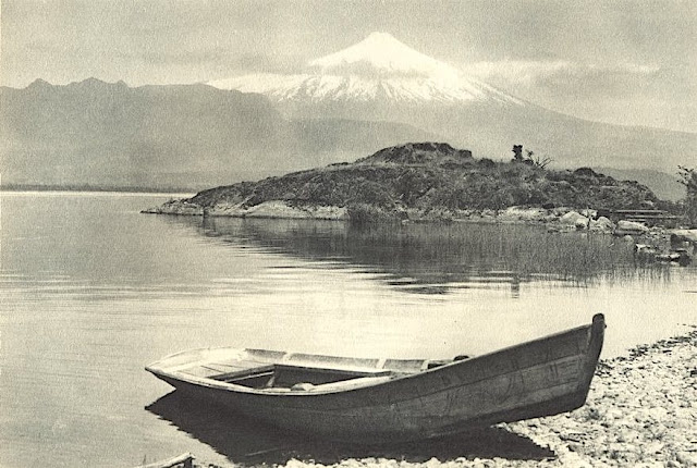
VOLCÀN ORSONO PHOTOGRAPHED BY ROBERT GERSTMANN


https://wanderingvertexes.blogspot.com/2021/03/volcan-orsono-photographed-by-robert.html

ROBERT GERSTMANN (1896-1960)
Volcàn Orsono (2,652 m - 8700 ft)
Chile

in Lago Villarrica e Volcan Orsono, photo, 1932


The volcano
The Osorno is a stratovolcano located between the province of Osorno and that of Llanquihue, in the Lakes region of Chile. At an altitude of 2,652 meters, it is the most active volcano in the southern Chilean Andes.  It rises to the east of Lake Llanquihue, known worldwide as a symbol of the local landscape. The volcano also dominates Lake Todos los Santos. Its last eruption dates from 1869. Charles Darwin saw the Osorno from afar on his second voyage on HMS Beagle and witnessed its eruption1 in January 18352. Its first ascent was made in 1848 by Jean Renous.

The photographer
Robert Gerstmann was a photographer very famous in South America. Gerstmann was a Vienna born electrical engineer who, as a young man, developed an interest in photography. In 1924, he immigrated to Chile and from there traveled to Bolivia, where he made some 5000 photographs, a selection of which appear as photogravures in his Bolivia, 150 Grabados en Cobre (1928), which was reissued in 1996 by the Fundación Quipus in La Paz. Gerstmann ranged far, photographing the altiplano from La Paz south to the Argentine border, west to the Chilean border, and east to the Yungas, Cochabamba, Santa Cruz, and the lowlands along the Ríos Beni and Mamoré. Only Tarija and the Chaco escaped his lens. Five of his photographs illustrate Stewart E. McMillan's "The Heart of Aymara Land" National Geographic Magazine (February 1927), and several appear in Gustavo-Adolfo Otero's Bolivia (Guía Sinóptica) 1929. Gerstmann settled in Santiago in 1929. He published other photo albums, including Chile: 280 grabados en cobre (1932), Colombia: 200 grabados en cobre (1951), and Chile en 110 cuadros (1960?), and dabbled in film-making in Bolivia. He is thought to have died in Santiago ca. 1960. Several thousand of his glass plates are said to be at a university in Antofagasta. 


_______________________________
2021 - Wandering Vertexes...
by Francis Rousseau