google.com, pub-0288379932320714, DIRECT, f08c47fec0942fa0 GRAVIR LES MONTAGNES... EN PEINTURE: Italy
Showing posts with label Italy. Show all posts

Sunday, August 28, 2022

CINQUE TORRI PAINTED BY EDWARD H. COMPTON


EDWARD H. COMPTON (1881-1960) Cinque Torri (2,361 m  -7,746 ft) Italy  In "Cinque Torri, Bei Cortina,Süd Tirol", 1930, oil on canvas


EDWARD H. COMPTON (1881-1960)
Cinque Torri (2,361 m  -7,746 ft)
Italy

In "Cinque Torri, Bei Cortina,Süd Tirol", 1930, oil on canvas


The mountains
Cinque Torri  (2,361 m  -7,746 ft) (sometimes named also Cinque Torri di Averau) comprise a small rock formation belonging to Nuvolao group in the Dolomiti Ampezzane (part of the Eastern Dolomites) north-west of San Vito di Cadore and south-west of Cortina d'Ampezzo.  Cinque Torri, as all the other mountains in the area, are made of dolomite, with a particular pale grey colour. The group is formed by five towers (which give the name to the mountain) with a maximum elevation of 2,361 m (Torre Grande). Every "tower" has its own name:Torre Grande, the highest one has three very appealing peaks for rock climbers: Cima Nord, Cima Sud e Cima Ovest. They are located in the south-west area of the valley of Cortina d'Ampezzo, north of the Averau mountain, of which Cinque Torri can be considered a part. In the Cinque Torri area there are the following mountain huts :Rifugio Cinque Torri, m 2,137. During summer it is possible to make excursions in the woods and on paths, among which are the Alta Via 1 of the Dolomites, the "Muraglia di Giau". The towers also provide good and popular rock climbing with various routes at a range of grades up all of the towers.  In winter, Cinque Torri belong to an important ski area, whose tracks are part of the wider Dolomiti Superski area. They are thus linked to the nearby mountains Lagazuoi and Col Gallina. Until a few years ago it was possible to ski only towards Lagazuoi - Col Gallina - Cinque Torri, but beginning in the winter season of 2008–2009, it has been also possible to ski downhill from the Cinque Torri area to the higher area of Falzarego Pass by means of the "Croda Negra" lift and the corresponding track beyond Averau mountain. This area was theater of conflict between Italian and Austro-Hungarian troops during World War I; countless testimonies of the fighting and of the war shelters built by the Italian army are present and have been recently rebuilt, to create an open-air museum with historical itineraries.

The painter
Edward Harrison Compton (1881–1960) not to be confused with his father Edward Theodore Compton (1849-1921) was a German landscape painter and illustrator of English descent. Compton was born in Feldafing in Upper Bavaria, Germany, the second son of notable landscape painter Edward Theodore Compton. He received his early art training from his father, and after a period of study in London at the Central School of Arts and Crafts settled back in Bavaria. Like his father he was inspired by the Alps to become a mountain painter ("bergmaller") working in both oils and watercolour. However, an attack of Polio at the age of 28 meant that he had to find more accessible landscapes to paint in Germany, England northern Italy and Sicily. He also provided illustrations for several travel books published by A & C Black. Compton exhibited at galleries in Munich and Berlin, and also in England at the Royal Academy in London and in Bradford. He died in Feldafing in 1960.
He had two sisters, both of whom were artists: Marion Compton, the flowers and still-life painter, and Dora Keel-Compton, flower and mountain painter.

____________________________________________________________-
2022 - Wandering Vertexes...
Un blog de Francis Rousseau

Friday, April 29, 2022

MOUNT VESUVIUS SEEN FROM SORRENTE BY ALFRED DE CURZON


ALFRED DE CURZON (1820-1895) Mount Vesuvius (1,281 m- 4,203 ft at present) Italy  In "Sorrente, devant la mer de Naples ", 1851 Huile sur papier marouflé sur toile 24,5 x 33 cm, Collection privée, courtesy Galerie d'Athènes, Paris


ALFRED DE CURZON (1820-1895)
Mount Vesuvius (1,281 m- 4,203 ft at present)
Italy

In "Sorrente, devant la mer de Naples ", 1851, huile sur papier marouflé sur toile 24,5 x 33 cm,
Collection privée, courtesy Galerie d'Athènes, Paris

The painter
Alfred de Curzon is a French painter, grandson of Joseph-Emmanuel-Auguste-François de Lambertye and brother of Emmanuel Parent de Curzon. Alfred de Curzon's family is part of the aristocracy of western France. While he was a student, the painting Médée furieuse by Eugène Delacroix, exhibited at the Salon of 1838, made a strong impression on him. He tries his hand at pastel and decides to become a painter. He entered the 1 April 1840 at the School of Fine Arts in Paris in the studio of Michel Martin Drolling. On the advice of one of his classmates from the school, Louis Georges Brillouin (1817-1893), he changed studio to follow the lessons of Louis Cabat from 1845.
In 1849 he painted La Mort de Milon de Crotone. At the request of the Academy, he obtained from the minister the enjoyment of the pension of Rome for two years. There he met Alexandre Cabanel, Jean-Achille Benouville, François-Léon Benouville, Louis Français and Charles Busson who remained his friend. He travel to Greece in 1852 with the writer Edmond About and the architect Charles Garnier. Greek antiquity then strongly impregnated him and is found in many of his paintings.
He began at the Salon of 1843 with a painting entitled Landscape. He obtained a 2nd class medal in 1857, followed by recalls in 1859, 1861 and 1863. He was awarded a 3rd class medal at the Universal Exhibition of 1867.
Charles Baudelaire notes, in his Salon of 1845: "A serenade in a boat, - is one of the most distinguished things of the Salon. - The arrangement of all these figures is very happily conceived; the old man at the end of the boat, lying in the middle of the garlands, is a very pretty idea. - The compositions of M. Brillouin and that of M. Curzon have some analogy; they have this above all in common, that they are well drawn - and drawn with spirit."
Alfred de Curzon practiced all genres, but it was his landscapes that made him famous. Many drawings can be seen at the Sainte-Croix museum in Poitiers (France).

The mountain 
Mount Vesuvius (1,281 m- 4,203 ft at present) is one of those legendary and mythic mountains  the Earth  paid regularly tribute. Monte Vesuvio in Italian modern langage or Mons Vesuvius in antique Latin langage is a stratovolcano in the Gulf of Naples (Italy) about 9 km (5.6 mi) east of Naples and a short distance from the shore. 
It is one of several volcanoes which form the Campanian volcanic arc. Vesuvius consists of a large cone partially encircled by the steep rim of a summit caldera caused by the collapse of an earlier and originally much higher structure.
Mount Vesuvius is best known for its eruption in AD 79 that led to the burying and destruction of the Roman antique cities of Pompeii, Herculaneum, and several other settlements. That eruption ejected a cloud of stones, ash, and fumes to a height of 33 km (20.5 mi), spewing molten rock and pulverized pumice at the rate of 1.5 million tons per second, ultimately releasing a hundred thousand times the thermal energy released by the Hiroshima bombing. At least 1,000 people died in the eruption. The only surviving eyewitness account of the event consists of two letters by Pliny the Younger to the historian Tacitus.
Vesuvius has erupted many times since and is the only volcano on the European mainland to have erupted within the last hundred years. Nowadays, it is regarded as one of the most dangerous volcanoes in the world because of the population of 3,000,000 people living nearby and its tendency towards explosive eruptions (said Plinian eruptions). It is the most densely populated volcanic region in the world.
Vesuvius was formed as a result of the collision of two tectonic plates, the African and the Eurasian. The former was subducted beneath the latter, deeper into the earth. As the water-saturated sediments of the oceanic African plate were pushed to hotter depths in the earth, the water boiled off and caused the melting point of the upper mantle to drop enough to create partial melting of the rocks. Because magma is less dense than the solid rock around it, it was pushed upward. Finding a weak place at the Earth's surface it broke through, producing the volcano.
he area around Vesuvius was officially declared a national park on June 5, 1995. The summit of Vesuvius is open to visitors and there is a small network of paths around the mountain that are maintained by the park authorities on weekends.
There is access by road to within 200 metres (660 ft) of the summit (measured vertically), but thereafter access is on foot only. There is a spiral walkway around the mountain from the road to the crater.
The first funicular cable car on Mount Vesuvius opened in 1880. It was later destroyed by the 1944 eruption. "Funiculì, Funiculà", a famous Neapolitan song with lyrics by journalist Peppino Turco set to music by composer Luigi Denza, commemorates its opening.
 
_______________________________

2022 - Wandering Vertexes / Mountain painting
By Francis Rousseau

Saturday, April 23, 2022

THE MONT BLANC PAINTED BY CESARE MAGGI


CESARE MAGGI (1881-1962), The Mont Blanc (4,808.73 m -15,777 ft) France - Italy  In " Alla montagne, il Monte Biancho", fuile sur toile, détail.

CESARE MAGGI (1881-1962),
The Mont Blanc (4,808.73 m -15,777 ft)
France - Italy

In " Alla montagne, il Monte Biancho", oil on canvas 


The painter
The italian painter Cesare Maggi was born into a family of actors, Maggi embarked on classical studies at his father’s wish but also took up painting at a very early age His debut in Florence at the Esposizione Annuale della Società di Belle Arti di Firenze in 1898 was followed by a short trip to Paris to catch up with the latest developments.
The crucial turning point in Maggi’s art came in 1889 with the posthumous show of work by Giovanni Segantini held by the Milanese Society of Fine Arts, which prompted a definitive shift to landscape painting of a Divisionist character. After a short stay in the Engadin, he returned to Milan before finally settling in Turin. Commercial collaboration with Alberto Grubicy until 1913 enabled Maggi to establish himself quickly as one of the leading representatives of the second generation of Divisionist painters in Italy. He painted a repertoire of readily comprehensible mountain landscapes focusing primarily on aspects of the visual perception of the reflection of light and colour but lacking the deep spirituality of Segantini’s work. He took part in the major Italian and European exhibitions and the Venice Biennale devoted an entire room to his work at the Esposizione Internazionale d’Arte of Venice in 1912. After an interlude devoted to portrait painting in the same decade, the artist’s mature work focused on greater simplification of subject matter, mostly in landscapes.
Maggi obtained the chair in painting at the Albertina Academy, Turin, in 1936.


The mountain

The Mont-Blanc (in French) (4 ,808.73 m -15,777 ft) or Monte Bianco (in Italian), both meaning "White Mountain", is the highest mountain in the Alps and the highest in Europe after the Caucasus peaks. It is ranked 11th in the world in topographic prominence. The Mont Blanc is one of the Seven Summit, which includes the highest mountains of each of the seven continents. Summiting all of them is regarded as a mountaineering challenge, first achieved on April 30, 1985 by Richard Bass. The 7 highest summit, (which are obviously 8 with 2 in Europe !) are : Mount Everest (8,848m), Aconcagua (6,961m), Mt Denali or Mc Kinley (6,194m), Kilimandjaro (5,895m), Mt Elbrus (5,642m), Mount Vinson (4,892m) and Mount Kosciuszko (2,228m) in Australia.
The mountain lies in a range called the Graian Alps, between the regions of Aosta Valley, Italy, and Savoie and Haute-Savoie, France. The location of the summit is on the watershed line between the valleys of Ferret and Veny in Italy and the valleys of Montjoie, and Arve in France. The Mont Blanc massif is popular for mountaineering, hiking, skiing, and snowboarding.
The three towns and their communes which surround Mont Blanc are Courmayeur in Aosta Valley, Italy, and Saint-Gervais-les-Bains and Chamonix in Haute-Savoie, France. A cable car ascends and crosses the mountain range from Courmayeur to Chamonix, through the Col du Géant. Constructed beginning in 1957 and completed in 1965, the 11.6 km (7¼ mi) Mont Blanc Tunnel runs beneath the mountain between these two countries and is one of the major trans-Alpine transport routes.
Since the French Revolution, the issue of the ownership of the summit has been debated.
From 1416 to 1792, the entire mountain was within the Duchy of Savoy. In 1723 the Duke of Savoy, Victor Amadeus II, acquired the Kingdom of Sardinia. The resulting state of Sardinia was to become preeminent in the Italian unification.[ In September 1792, the French revolutionary Army of the Alps under Anne-Pierre de Montesquiou-Fézensac seized Savoy without much resistance and created a department of the Mont-Blanc. In a treaty of 15 May 1796, Victor Amadeus III of Sardinia was forced to cede Savoy and Nice to France. In article 4 of this treaty it says: "The border between the Sardinian kingdom and the departments of the French Republic will be established on a line determined by the most advanced points on the Piedmont side, of the summits, peaks of mountains and other locations subsequently mentioned, as well as the intermediary peaks, knowing: starting from the point where the borders of Faucigny, the Duchy of Aoust and the Valais, to the extremity of the glaciers or Monts-Maudits: first the peaks or plateaus of the Alps, to the rising edge of the Col-Mayor". This act further states that the border should be visible from the town of Chamonix and Courmayeur. However, neither the peak of the Mont Blanc is visible from Courmayeur nor the peak of the Mont Blanc de Courmayeur is visible from Chamonix because part of the mountains lower down obscure them. A Sardinian Atlas map of 1869 showing the summit lying two thirds in Italy and one third in France.
After the Napoleonic Wars, the Congress of Vienna restored the King of Sardinia in Savoy, Nice and Piedmont, his traditional territories, overruling the 1796 Treaty of Paris. Forty-five years later, after the Second Italian War of Independence, it was replaced by a new legal act. This act was signed in Turin on 24 March 1860 by Napoleon III and Victor Emmanuel II of Savoy, and deals with the annexation of Savoy (following the French neutrality for the plebiscites held in Tuscany and Emilia-Romagna to join the Kingdom of Sardinia, against the Pope's will). A demarcation agreement, signed on 7 March 1861, defines the new border. With the formation of Italy, for the first time Mont Blanc is located on the border of France and Italy.
The 1860 act and attached maps are still legally valid for both the French and Italian governments. One of the prints from the 1823 Sarde Atlas positions the border exactly on the summit edge of the mountain (and measures it to be 4,804 m (15,761 ft) high). The convention of 7 March 1861 recognises this through an attached map, taking into consideration the limits of the massif, and drawing the border on the icecap of Mont Blanc, making it both French and Italian.Watershed analysis of modern topographic mapping not only places the main summit on the border, but also suggests that the border should follow a line northwards from the main summit towards Mont Maudit, leaving the southeast ridge to Mont Blanc de Courmayeur wholly within Italy.
Although the Franco-Italian border was redefined in both 1947 and 1963, the commission made up of both Italians and French ignored the Mont Blanc issue. In the early 21st century, administration of the mountain is shared between the Italian town of Courmayeur and the French town of Saint-Gervais-les-Bains, although the larger part of the mountain lies within the commune of the latter.

___________________________________________
2022- Wandering Vertexes...
by Francis Rousseau

Tuesday, March 22, 2022

THE MER DE GLACE AND GRAND CHARMOZ PAINTED BY GABRIEL LOPPÉ


GABRIEL LOPPÉ (1825-1913), Les Aiguilles du Grand Charmoz (3,445m - 11,302ft) France  In La Mer de Glace et les Grands Charmoz, Chamonix, Huile sur toile, Courtesy JohnMitchell Fine Arts, London, Artcurial Paris,

GABRIEL LOPPÉ (1825-1913),
Les Aiguilles du Grand Charmoz (3,445m -11,302ft)
France

In La Mer de Glace et les Grands Charmoz, Chamonix, Huile sur toile, 

Courtesy John Mitchell Fine Arts, London, and Artcurial Paris,

 
The painter

Toussaint Gabriel Loppé was a French painter, photographer and mountaineer. He became the first foreigner to be made a member of the Alpine Club in London. His father was a captain in the French Engineers and Loppé's childhood was spent in many different towns in south-eastern France. Aged twenty-one Loppé climbed a small mountain in the Languedoc and found a group of painters sketching on the summit. He had found his calling and subsequently went off to Geneva where he met the reputed leading Swiss landscapist, Alexandre Calame (1810 -1864). Loppé took up mountaineering in Grindelwald in the 1850s and made friends easily with the many English climbers in France and Switzerland. Although he was frequently labelled as a pupil of Calame and his rival François Diday, Loppé was almost an entirely self-taught artist. He became the first painter to work at higher altitudes during climbing expeditions earning the right to be considered the founder of the peintres-alpinistes school, which became established in the Savoie at the turn of the nineteenth century.
Notable followers of Loppé include, Charles Henri Contencin (1875-1955) and Jacques Fourcy (1906-1990). Together with the first ascent of Mt Mallet in Chamonix’s Grandes Jorasses range, Loppé made over 40 ascents of Mont Blanc during his climbing career, which lasted until the late 1890s. He frequently made oil sketches from alpine summits, including a panorama of the view from the summit of Mont Blanc.
His paintings became celebrated for their atmosphere and spontaneity and he soon found himself taking part in many exhibitions in London and in Paris.
By 1896 Loppé had spent over fifty seasons climbing and painting in Chamonix. As the valley’s unrivalled ‘Court painter’ his work was in constant demand with the majority of his pictures going to English climbers and summer tourists.
In his later years, Loppé became fascinated with photography and was quite an innovator in this field too. His long exposure photograph of the Eiffel Tower struck by lightning, now in the Musée d'Orsay in Paris remains one of his iconic images. 

 
The mountain
The Aiguille des Grands Charmoz (3,445 m), is one of the Chamonix needles in the Mont Blanc massif. It is made up of a ridge bristling with " gendarmes", including La Carrée, and Bâton Wicks. The first ascent was done on August 9, 1885 by H. Dunod and P. Vignon with the guides J. Desailloux, F. Folliguet, F. and G. Simond, by the corridor Charmoz-Grépon. It is today the normal way of descent, the climb generally being made by the south-west slope and the northwestern edge (AD +), climbed 15 July 1880 by Albert F. Mummery with Alexandre Burgener and Benedikt Venetz, which stopped before the summit at point 3 435 m. The Aiguille des Grands Charmoz is linked with the Aiguille du Grépon for the crossing of Charmoz-Grépon (D), one of the great rocky classics of the Mont Blanc massif. The first crossing was done by Laurent Croux in 1904. The first ascent of the north face, via the needle of the Republic, and crossing the edges of the Charmoz was done by Raymond Leininger and G. Bicavelle in 1946. In 1974, Jean-Claude Droyer succeeded the solo climb of the western pillar of the Grand Charmoz (Cordier lane opened in 1970 by Patrick Cordier).
The Mt Blanc is one of the 7 highest summits in earth, (which are obviously 8 with 2 in Europe !):
Mount Everest (8,848m), Aconcagua (6,961m), Mt Denali or Mc Kinley (6,194m), Kilimandjaro (5,895m), Mt Elbrus (5,642m), Mount Vinson (4,892m) and Mount Kosciuszko (2,228m) in Australia.

The Glacier
The Mer de Glace (Sea of Ice) is an alpine valley glacier located on the northern slope of the Mont-Blanc massif. It is formed by the confluence of the Tacul glacier and the Leschaux glacier and flows into the Arve valley, on the territory of the municipality of Chamonix-Mont-Blanc, giving rise to the Arveyron. The glacier is seven kilometers long, its supply basin has a maximum length of twelve kilometers and an area of ​​40 km2, while its thickness reaches 300 meters. In the middle of the 20th century, an ice cave was pierced for the first time in the Mer de Glace. Due to the attraction's success, a cable car was put into service in 1961 to access it, then replaced by a cable car in 1988. Since 1973, an underground hydroelectric power station has been using the meltwater from the glacier.
Almost a million visitors go to Montenvers every year to contemplate the Mer de Glace. During peak periods, half of them visit the ice cave. Three museums are also located on the site. Skiing is possible from the Aiguille du Midi in winter. However, the retreat of the glacier, measured since 1860-1870, causes a loss of thickness of 120 meters in a century in its terminal part. It causes difficulties at the level of the ice cave, where more and more steps are necessary to reach the gondola, and requires considering its upstream movement, like the catchment of the hydroelectric power station in 2011.
_______________________________
2022 - Wandering Vertexes...
by Francis Rousseau


Sunday, November 7, 2021

MOUNT CATALFANO PAINTED BY FRANCESCO LOJACONO


FRANCESCO LOJACONO (1838-1915) Mount Catalfano (376m -1, 233ft) Italy (Sicily)   In View of Mount Catalfano, Sicily, 1865-1870, oil on canvas  45x109 cm, Gallery of Modern Art in Palermo


FRANCESCO LOJACONO (1838-1915)
Mount Catalfano (376m -1, 233ft)
Italy (Sicily)

In View of Mount Catalfano, 1865-1870, oil on canvas, 45x109 cm,
Villa Malfitano - Gallery of Modern Art in Palermo

The mountain
Monte Catalfano (376m -1,233ft)   is a mountain in western Sicily, in the province of Palermo.
The etymology, of Arabic origin, is uncertain: the first part goes back to the Arabic qal'at, while the second element could derive from ḥalfān, "oath" [1]. Attested in 1573 as Ialfano by the geographer Tommaso Fazello, in the 17th century the toponym is in the current form of Catalfano.
The limestone mountain extends into the Tyrrhenian Sea with the promontory of Capo Zafferano. In the rocky body there are a few deep cavities (the zubbi) which host large entomological populations. Among these, the Zubbio di San Pietro Cozzo, the Hermit Cave and the Cala dell'Osta Cave.
Typical Mediterranean flora includes Chamaerops humilis, mastic tree, tree spurge, Artemisia arborescens and many species of orchids (Ophrys Bombyx, Ophrys mirabilis, Ophrys lunulata, Ophrys oxyrrhynchos, Ophrys explanata, switched Neotinea and orchis brancifortii).
The avifauna includes, among others, the peregrine falcon, the kestrel, the hawk, the wild pigeon, the collared dove and the goldfinch.

The painter
Francesco Lojacono was an Italian painter, considered the most important landscape painter of the 19th century Sicilian. He was among the first painters to use photography as a reference to create his works.
In search of a pictorial rendering closer to reality, he was among the first painters to be interested in photography.
Most of his paintings are kept in Villa Malfitano, the Gallery of Modern Art in Palermo and in the Civic Museum of Agrigento as part of the Sinatra collection. Some of his works are exhibited at the National Gallery of Modern and Contemporary Art in Rome, at the Galleries of Italy in Milan, the Capodimonte Museum in Naples and at the Villa Zito museum of the Sicily Foundation in Palermo.

_______________________________

2021 - Wandering Vertexes...
by Francis Rousseau


Thursday, October 21, 2021

MONTE CIVETTA PAINTED BY ELIJAH WALTON


ELIJAH WALTON (1832-1880), Monte Civetta (3,220 m - 10, 580 ft) Italy  In Dolomites - in Spring. Civetta from Forcella Staulanza (North East), 1875 oil on canvas, 38 x 183 cm
 
ELIJAH WALTON (1832-1880)
Monte Civetta (3,220 m - 10, 580 ft)
Italy

In Dolomites - in Spring. Civetta from Forcella Staulanza (North East), 1875 oil on canvas, 38 x 183 cm.


The mountain
Monte Civetta (3,220 m - 10, 580 ft) is a prominent and major mountain of the Dolomites, in the Province of Belluno in northern Italy. Its north-west face can be viewed from the Taibon Agordino valley, and is classed as one of the symbols of the Dolomites. The mountain is thought to have been first climbed by Simeone di Silvestro in 1855, which, if true, makes it the first major Dolomite peak to be climbed. The north-western face, with its 1,000-metre-high cliff, was first climbed in 1925 by Emil Solleder and Gustl Lettenbauer. It is historically considered the first "sixth grade" in six-tier scale of alpinistic difficulties proposed by Willo Welzenbach (corresponding to 5.9). Thirty years later UIAA used this as a basis for its grading system. The famed Svan mountain climber Mikhail Khergiani died in a climbing accident on Monte Civetta in 1969.

The artist
The British landscapist, Elijah Walton is best known for his landscapes of mountains in the Alps. Due to the poorness of his family, without the help of one or two friends he would have been unable to study art, for which his talent was soon exhibited. After passing some years at the art academy in Birmingham, he became at the age of eighteen a student at the Royal Academy Schools in London, where he had already exhibited a picture. There he worked assiduously, drawing from the antique and from life. Nearly ten years later an accidental circumstance revealed to a friend his capabilities in mountain landscape, and in 1860, immediately after his marriage, he went to Switzerland. Thence he proceeded to Egypt, where unhappily his wife died of dysentery near the second cataract. He remained in the east, spending some time in Syria and at Constantinople, till the spring of 1862, when he returned for a short time to London. But for the next five years he was much abroad, working either in the Alps or in Egypt. His sketching tours then became rarer and shorter, though he visited Greece, Norway, and the Alps. At first he resided at Staines, then removed to the neighbourhood of Bromsgrove, living most of the time at the Forelands, near that town. In 1872 his wife died, and the loss permanently affected his health. He died on 25 August 1880 at his residence Beacon Farm, Lickey near Bromsgrove in Worcestershire, leaving three sons. Walton's life was bound up in his art. He worked both in oils and in watercolours, but was more successful with the latter. Most thorough and conscientious in the study both of form and of colour, he delighted especially in mountain scenery and in atmospheric effects, such as an Alpine peak breaking through the mists, or a sunset on the Nile. Few men have equalled him in the truthful rendering of rock structure and mountain form. His pictures were much appreciated by lovers of nature; but as those of small size sold better than larger and more highly finished works, this fostered a tendency to mannerisms.

___________________________________________
2021 - Wandering Vertexes...
by Francis Rousseau

Wednesday, October 13, 2021

THE MONT BLANC & THE MER DE GLACE BY JOHN RUSKIN

JOHN RUSKIN (1819-1900), The Mont Blanc (4,808.13 m - 15,776.7 ft) France - Italy border  In Mer de Glace Chamonix, watercolor on paper, 1849, Ruskin Foundation


JOHN RUSKIN (1819-1900),
The Mont Blanc (4,808.13 m - 15,776.7 ft)
France - Italy border

In Mer de Glace Chamonix, watercolor on paper, 1849, Ruskin Foundation

The painter  
John Ruskin was the leading English art critic of the Victorian era, as well as an art patron, draughtsman, watercolourist, a prominent social thinker and philanthropist. He wrote on subjects as varied as geology, architecture, myth, ornithology, literature, education, botany and political economy. His writing styles and literary forms were equally varied. Ruskin also penned essays and treatises, poetry and lectures, travel guides and manuals, letters and even a fairy tale. The elaborate style that characterised his earliest writing on art was later superseded by a preference for plainer language designed to communicate his ideas more effectively. In all of his writing, he emphasised the connections between nature, art and society. He also made detailed sketches and paintings of rocks, plants, birds, landscapes, and architectural structures and ornamentation. He was hugely influential in the latter half of the 19th century, and up to the First World War. After a period of relative decline, his reputation has steadily improved since the 1960s with the publication of numerous academic studies of his work. Today, his ideas and concerns are widely recognised as having anticipated interest in environmentalism, sustainability and craft.
Ruskin first came to widespread attention with the first volume of Modern Painters (1843), an extended essay in defence of the work of J. M. W. Turner in which he argued that the principal role of the artist is "truth to nature". From the 1850s he championed the Pre-Raphaelites who were influenced by his ideas. His work increasingly focused on social and political issues. Unto This Last (1860, 1862) marked the shift in emphasis. In 1869, Ruskin became the first Slade Professor of Fine Art at the University of Oxford, where he established the Ruskin School of Drawing. In 1871, he began his monthly "letters to the workmen and labourers of Great Britain", published under the title Fors Clavigera (1871–1884). In the course of this complex and deeply personal work, he developed the principles underlying his ideal society. As a result, he founded the Guild of St George, an organisation that endures today.

The mountain
Mont Blanc (in French) or Monte Bianco (in Italian), both meaning "White Mountain", is the highest mountain in the Alps and the highest in Europe after the Caucasus peaks. It rises 4,808.73 m (15,777 ft) above sea level and is ranked 11th in the world in topographic prominence. The Mont Blanc is one of the Seven Summit, which includes the highest mountains of each of the seven continents. Summiting all of them is regarded as a mountaineering challenge, first achieved on April 30, 1985 by Richard Bass. The 7 highest summit, (which are obviously 8 with 2 in Europe !) are : Mount Everest (8,848m), Aconcagua (6,961m), Mt Denali or Mc Kinley (6,194m), Kilimandjaro (5,895m), Mt Elbrus (5,642m), Mount Vinson (4,892m) and Mount Kosciuszko (2,228m) in Australia.
The Glacier
The Mer de Glace  ( Sea of Ice) is an alpine valley glacier located on the northern slope of the Mont-Blanc massif, in the French department of Haute-Savoie. It is formed by the confluence of the Tacul glacier and the Leschaux glacier and flows into the Arve valley, on the territory of the municipality of Chamonix-Mont-Blanc, giving rise to the Arveyron. The glacier is seven kilometers long, its supply basin has a maximum length of twelve kilometers and an area of ​​40 km2, while its thickness reaches 300 meters.
In the seventeenth century, the glacier, which descends into the valley and threatens homes, is feared by the population, so that only its terminal tongue is known, under the name of Glacier des Bois. Then finished by a natural cave, it is the subject of numerous paintings. Its current name was given to it in 1741 by William Windham during the exploration he carried out with his British compatriot Richard Pococke. Two decades later, Horace-Bénédict de Saussure, the future instigator of the first ascent of Mont Blanc, made several observations of the glacier and asked Marc-Théodore Bourrit to promote it. It thus contributes to the development of alpine tourism and to the visit of numerous personalities of letters as well as of the aristocracy; scientists carried out experiments there in the 19th century. To shelter them, three increasingly large and comfortable shelters were successively built in Montenvers. At the beginning of the 20th century, the Montenvers railway, leaving from Chamonix, was created. In the middle of the century, an ice cave was pierced for the first time in the Mer de Glace. Due to the attraction's success, a cable car was put into service in 1961 to access it, then replaced by a cable car in 1988. Since 1973, an underground hydroelectric power station has been using the meltwater from the glacier.
Almost a million visitors go to Montenvers every year to contemplate the Mer de Glace. During peak periods, half of them visit the ice cave. Three museums are also located on the site. Skiing is possible from the Aiguille du Midi in winter. However, the retreat of the glacier, measured since 1860-1870, causes a loss of thickness of 120 meters in a century in its terminal part. It causes difficulties at the level of the ice cave, where more and more steps are necessary to reach the gondola, and requires considering its upstream movement, like the catchment of the hydroelectric power station in 2011.
_______________________________


2021 - Wandering Vertexes...
by Francis Rousseau

Wednesday, September 22, 2021

THE CERVIN / MATTERHORN PAINTED BY GABRIEL LOPPÉ

GABRIEL LOPPÉ (1825-1913) Le Cervin or Matterhorn (4,478m -14,691ft) Switzerland - Italy border  In "Le Mont Cervin par temps nuageux, l'après midi", étude, huile sur toile 29x 18, 5cm, 1884.

GABRIEL LOPPÉ (1825-1913)
Le Cervin or Matterhorn (4,478m -14,691ft)
Switzerland - Italy border

In "Le Mont Cervin par temps nuageux, l'après midi", étude, huile sur toile 29x 18, 5cm, 1884.

The mountain
The Mont Cervin (4,478m -14,691ft) also known as the Matterhorn is an alpine summit located on the Swiss-Italian border between the canton of Valais and the Aosta Valley in Switzerland. It has several other names: Cervino in Italian, Grand'Bèca in Arpitan, Matterhorn in German. The Cervin / Matterhorn is the most famous mountain in Switzerland, including the pyramidal shape that it offers from the village of Zermatt, in the German-speaking part of the canton of Valais.
Its four sides are joined about 400 meters below the summit in a summit pyramid, called "roof." Its summit is a broad ridge about two meters, on which stand actually two summits: one called "Swiss summit," the farther east, and the "Italian summit" slightly lower (4,476 meters), on the west side of the ridge. The two are separated by a notch in the hollow of which a cross was laid in September 1901.
Its north face is one of the three great north faces of the Alps with the Eiger and the Grandes Jorasses.
The most famous faces of the Matterhorn are the faces east and north, seen from Zermatt. The first
1, 000 meters high, has great risk of falling rocks, which makes it dangerous climb. The north face high of 1100 meters, is one of the most dangerous sides of the Alps, particularly because of the risks of landslides and storms. The south side, overlooking the Breuil (Valtournenche above) is high, it, 1 350 meters. This is the face that offers the most channels. And finally, the west face the highest with its 1400 meters, is the one that is the subject of fewer climbs attempts. Between the west side and the north side there is also the north-northwest side, which does not stretch to the summit but stopped Zmutt Nose, on the bridge of the same name. This is the most dangerous route for climbing the Matterhorn. There is also a south-facing southeast, deemed to be the most difficult of the south face route, which leads to the Pic Muzio, on Furggen Shoulder.
Due to its pyramidal form, the Matterhorn has four main ridges, through which pass most of climbing routes. The easiest ridge, that borrows the normal route, is the Hörnli ridge (Hörnligrat in German): it is between the faces east and north, facing the Zermatt valley. Further west lies the Zmutt ridge (Zmuttgrat), between the north and west sides. Between the western and southern sides is the Lion ridge (Liongrat), also known as Italian ridge, which passes through the Tyndall peak, summit of the southern part of the west side, at which begins the upper face. Finally, the south side is separated from the face is Furggen
Swiss normal route from the cabin of the Hörnli, located at 3260 meters. Since Zermatt is accessed by gondola Schwarzsee; there are 700 vertical meters to the hut and 1200 vertical meters to the summit.
Difficulty (Hörnli ridge): AD (fairly difficult), 3 climbing passage; fixed ropes were installed near the top for easy ascension.
The Italian normal route, taking his departure in Breuil, follows almost entirely the southwest ridge, called the Lion ridge. It was inaugurated by the guide valtournain Jean-Antoine Carrel 17 July 1865.
The climb from the Italian side includes three steps:
- du Breuil (2012 meters) at the shelter Duke of Abruzzi in Oriondé (2802 meters)
- the refuge Duca degli Abruzzi refuge to Jean-Antoine Carrel (3830 meters)
- Jean-Antoine Carrel refuge at the summit (4478 meters).
The ascent by Hörnli ridge, July 14, 1865, was considered the last of the great feats of mountaineering in the Alps. But this ascent error ended at the beginning of the descent, in the death of 4 of the 7 members of the roped Victorieuse.

The painter
Toussaint Gabriel Loppé was a French painter, photographer and mountaineer. He became the first foreigner to be made a member of the Alpine Club in London. His father was a captain in the French Engineers and Loppé's childhood was spent in many different towns in south-eastern France. Aged twenty-one Loppé climbed a small mountain in the Languedoc and found a group of painters sketching on the summit. He had found his calling and subsequently went off to Geneva where he met the reputed leading Swiss landscapist, Alexandre Calame (1810 -1864). Loppé took up mountaineering in Grindelwald in the 1850s and made friends easily with the many English climbers in France and Switzerland. Although he was frequently labelled as a pupil of Calame and his rival François Diday, Loppé was almost an entirely self-taught artist. He became the first painter to work at higher altitudes during climbing expeditions earning the right to be considered the founder of the peintres-alpinistes school, which became established in the Savoie at the turn of the nineteenth century.
Notable followers of Loppé include, Charles Henri Contencin (1875-1955) and Jacques Fourcy (1906-1990). Together with the first ascent of Mt Mallet in Chamonix’s Grandes Jorasses range, Loppé made over 40 ascents of Mont Blanc during his climbing career, which lasted until the late 1890s. He frequently made oil sketches from alpine summits, including a panorama of the view from the summit of Mont Blanc.
His paintings became celebrated for their atmosphere and spontaneity and he soon found himself taking part in many exhibitions in London and in Paris.
By 1896 Loppé had spent over fifty seasons climbing and painting in Chamonix. As the valley’s unrivalled ‘Court painter’ his work was in constant demand with the majority of his pictures going to English climbers and summer tourists.
In his later years, Loppé became fascinated with photography and was quite an innovator in this field too. His long exposure photograph of the Eiffel Tower struck by lightning, now in the Musée d'Orsay in Paris remains one of his iconic images.

___________________________________________

2021 - Wandering Vertexes...
by Francis Rousseau


Wednesday, August 11, 2021

DIE HOCHFEILER OR GRAN PILASTRO BY AUGUST STRINDBERG


-AUGUST STRINDBERG (1849-1912) The Hochfeiler or Gran Pilastro  (3,510 m -11,520 ft) Austria - Italy border In Alpine Landscape Austria, oil on canvas , Priva te collection

AUGUST STRINDBERG (1849-1912)
The Hochfeiler or Gran Pilastro (3,510 m -11,520 ft)
Austria - Italy border
 
In Alpine Landscape Austria, oil on canvas, Private collection

The artist
Johan August Strindberg known to be a famous  Swedish playwright was also  a novelist a poet, an essayist and a painter. Strindberg, something of a polymath, was also a telegrapher, theosophist, photographer and alchemist!  Painting and photography offered vehicles for his belief that chance played a crucial part in the creative process. Strindberg's paintings were unique for their time, and went beyond those of his contemporaries for their radical lack of adherence to visual reality. The 117 paintings that are acknowledged as his were mostly painted within the span of a few years, and are now seen by some as among the most original works of 19th-century art. Today, his best-known pieces are stormy, expressionist seascapes, selling at high prices in auction houses. Though Strindberg was friends with Edvard Munch and Paul Gauguin, and was thus familiar with modern trends, the spontaneous and subjective expressiveness of his landscapes and seascapes can be ascribed also to the fact that he painted only in periods of personal crisis. Anders Zorn also did a portrait.
Strindberg's interest in photography resulted, among other things, in a large number of arranged self-portraits in various environments, which now number among the best-known pictures of him. Strindberg also embarked on a series of camera-less images, using an experimental quasi-scientific approach. He produced a type of photogram that encouraged the development and growth of crystals on the photographic emulsion, sometimes exposed for lengthy periods to heat or cold in the open air or at night facing the stars. The suggestiveness of these, which he called Celestographs, provided an object for contemplation, and he noted: "Today, in these days of x-rays, the miracle was that neither a camera nor a lens was used. For me this means a great opportunity to demonstrate the real circumstances by means of my photographs made without a camera and lens, recording the firmament in early spring 1894."
His interest in the occult in the 1890s finds sympathy with the chance quality of these images, but for him they are also scientific. In 1895 Strindberg met Camille Flammarion and became a member of the Société astronomique de France. He gave some of his experimental astronomical photographs to the Society

The mountain
The Hochfeiler 3,510 m (11,520 ft) called Gran Pilastro in italian is a mountain, 3,510 metres high, and the highest peak in the Zillertal Alps on the border between Tyrol, Austria, and South Tyrol, Italy.

___________________________________________

2021 - Wandering Vertexes...
by Francis Rousseau

Saturday, May 15, 2021

MONTE BIANCO PAINTED BY CESARE MAGGI


Cesare Maggi (1881–1962) The Mont Blanc (4,808.13 m - 15,776.7 ft) France - Italy border  In  A view of Mont Blanc from Entrèves, Oil on canvas ,70x100 cm,  Private collection
 
 CESARE MAGGI (1881-1962)
The Mont Blanc (4,808.13 m - 15,776.7 ft)
France - Italy border

In  A view of Monte Bianco from Entrèves, Oil on canvas, 70x100 cm,  Private collection 


The painter
The italian painter Cesare Maggi was born into a family of actors, Maggi embarked on classical studies at his father’s wish but also took up painting at a very early age His debut in Florence at the Esposizione Annuale della Società di Belle Arti di Firenze in 1898 was followed by a short trip to Paris to catch up with the latest developments.
The crucial turning point in Maggi’s art came in 1889 with the posthumous show of work by Giovanni Segantini held by the Milanese Society of Fine Arts, which prompted a definitive shift to landscape painting of a Divisionist character. After a short stay in the Engadin, he returned to Milan before finally settling in Turin. Commercial collaboration with Alberto Grubicy until 1913 enabled Maggi to establish himself quickly as one of the leading representatives of the second generation of Divisionist painters in Italy. He painted a repertoire of readily comprehensible mountain landscapes focusing primarily on aspects of the visual perception of the reflection of light and colour but lacking the deep spirituality of Segantini’s work. He took part in the major Italian and European exhibitions and the Venice Biennale devoted an entire room to his work at the Esposizione Internazionale d’Arte of Venice in 1912. After an interlude devoted to portrait painting in the same decade, the artist’s mature work focused on greater simplification of subject matter, mostly in landscapes.
Maggi obtained the chair in painting at the Albertina Academy, Turin, in 1936.


The mountain
Mont Blanc (in French) or Monte Bianco (in Italian), both meaning "White Mountain", is the highest mountain in the Alps and the highest in Europe after the Caucasus peaks. It rises 4,808.73 m (15,777 ft) above sea level and is ranked 11th in the world in topographic prominence. The Mont Blanc is one of the Seven Summit, which includes the highest mountains of each of the seven continents. Summiting all of them is regarded as a mountaineering challenge, first achieved on April 30, 1985 by Richard Bass. The 7 highest summit, (which are obviously 8 with 2 in Europe !) are : Mount Everest (8,848m), Aconcagua (6,961m), Mt Denali or Mc Kinley (6,194m), Kilimandjaro (5,895m), Mt Elbrus (5,642m), Mount Vinson (4,892m) and Mount Kosciuszko (2,228m) in Australia.
The mountain lies in a range called the Graian Alps, between the regions of Aosta Valley, Italy, and Savoie and Haute-Savoie, France. The location of the summit is on the watershed line between the valleys of Ferret and Veny in Italy and the valleys of Montjoie, and Arve in France. The Mont Blanc massif is popular for mountaineering, hiking, skiing, and snowboarding.
The three towns and their communes which surround Mont Blanc are Courmayeur in Aosta Valley, Italy, and Saint-Gervais-les-Bains and Chamonix in Haute-Savoie, France. A cable car ascends and crosses the mountain range from Courmayeur to Chamonix, through the Col du Géant. Constructed beginning in 1957 and completed in 1965, the 11.6 km (7¼ mi) Mont Blanc Tunnel runs beneath the mountain between these two countries and is one of the major trans-Alpine transport routes.
Since the French Revolution, the issue of the ownership of the summit has been debated.
From 1416 to 1792, the entire mountain was within the Duchy of Savoy. In 1723 the Duke of Savoy, Victor Amadeus II, acquired the Kingdom of Sardinia. The resulting state of Sardinia was to become preeminent in the Italian unification.[ In September 1792, the French revolutionary Army of the Alps under Anne-Pierre de Montesquiou-Fézensac seized Savoy without much resistance and created a department of the Mont-Blanc. In a treaty of 15 May 1796, Victor Amadeus III of Sardinia was forced to cede Savoy and Nice to France. In article 4 of this treaty it says: "The border between the Sardinian kingdom and the departments of the French Republic will be established on a line determined by the most advanced points on the Piedmont side, of the summits, peaks of mountains and other locations subsequently mentioned, as well as the intermediary peaks, knowing: starting from the point where the borders of Faucigny, the Duchy of Aoust and the Valais, to the extremity of the glaciers or Monts-Maudits: first the peaks or plateaus of the Alps, to the rising edge of the Col-Mayor". This act further states that the border should be visible from the town of Chamonix and Courmayeur. However, neither the peak of the Mont Blanc is visible from Courmayeur nor the peak of the Mont Blanc de Courmayeur is visible from Chamonix because part of the mountains lower down obscure them. A Sardinian Atlas map of 1869 showing the summit lying two thirds in Italy and one third in France.
After the Napoleonic Wars, the Congress of Vienna restored the King of Sardinia in Savoy, Nice and Piedmont, his traditional territories, overruling the 1796 Treaty of Paris. Forty-five years later, after the Second Italian War of Independence, it was replaced by a new legal act. This act was signed in Turin on 24 March 1860 by Napoleon III and Victor Emmanuel II of Savoy, and deals with the annexation of Savoy (following the French neutrality for the plebiscites held in Tuscany and Emilia-Romagna to join the Kingdom of Sardinia, against the Pope's will). A demarcation agreement, signed on 7 March 1861, defines the new border. With the formation of Italy, for the first time Mont Blanc is located on the border of France and Italy.
The 1860 act and attached maps are still legally valid for both the French and Italian governments. One of the prints from the 1823 Sarde Atlas positions the border exactly on the summit edge of the mountain (and measures it to be 4,804 m (15,761 ft) high). The convention of 7 March 1861 recognises this through an attached map, taking into consideration the limits of the massif, and drawing the border on the icecap of Mont Blanc, making it both French and Italian.Watershed analysis of modern topographic mapping not only places the main summit on the border, but also suggests that the border should follow a line northwards from the main summit towards Mont Maudit, leaving the southeast ridge to Mont Blanc de Courmayeur wholly within Italy.
Although the Franco-Italian border was redefined in both 1947 and 1963, the commission made up of both Italians and French ignored the Mont Blanc issue. In the early 21st century, administration of the mountain is shared between the Italian town of Courmayeur and the French town of Saint-Gervais-les-Bains, although the larger part of the mountain lies within the commune of the latter.
 
___________________________________________
2021- Wandering Vertexes...
by Francis Rousseau 


Sunday, May 9, 2021

CEMBA VELLEY PAINTED BY ALBRECHT DÜRER


ALBRECHT  DÜRER (1471-1528) Cemba Valley (200 m -656 ft) Italy   In Landscape near Segonzano in the Cembra Valley (1495), Watercolor on paper, 21 x 31.2 cm. The Ashmolean Museum, Oxford

ALBRECHT  DÜRER (1471-1528)
Cemba Valley (200 m - 656 ft)
Italy

 In Landscape near Segonzano in the Cembra Valley (1495), Watercolour on paper, 21 x 31.2 cm.
The Ashmolean Museum, Oxford


About this watercolor

Dürer called this landscape watercolor, which was created during his second Italian journey, "wehlsch pirg" (Italian hills). Its topographical location was long disputed. The most convincing suggestion is that this is a depiction of the Cembra Valley near Segonzano. The free manner in which the scene is captured, with the relaxed light brushstrokes in the foreground while the background is recorded with a naturalistic delicacy, makes it understandable why Dürer's watercolor technique at this time has been compared with that of Paul Cézanne. Watercolours by Dürer mark him as one of the first European landscape artists, while his woodcuts revolutionized the potential of that medium.


The valley
Trentino Alto Adige is the northernmost Italian region and is overwhelmingly mountainous, marked by the steep and picturesque shapes of the Dolomites, with the exception of the Adige Valley and the Dei Laghi Valley, both located below 200 m altitude and therefore considered as a plain. These valleys include large flat areas such as Piana Rotaliana and Piana dell'Alto Garda. While in the southern part of the region, on the shores of Lake Garda, the altitude drops to 65m, the highest mountain ranges peak at over 3,900m. The topographic prominence thus reaches almost 4,000 m. The region is bordered to the east and southeast by Veneto, to the west and southwest by Lombardy, to the north and northeast by the Austrian Land of Tyrol and Salzburg, and to the north -west with the Swiss canton of Graubünden 2. Predoi is the northernmost municipality in the region and in Italy; the municipality is the only one in Italy to be located further north than the 47th parallel.
The region lies between the central and eastern Alps, while to the south the border is delimited by Lake Garda and the Vicentine Pre-Alps.


The artist
Within three months of his marriage, Dürer left for Italy, alone, perhaps stimulated by an outbreak of plague in Nuremberg. He made watercolour sketches as he traveled over the Alps. Some have survived and others may be deduced from accurate landscapes of real places in his later work, for example his engraving Nemesis. In Italy, he went to Venice to study its more advanced artistic world. Through Wolgemut's tutelage, Dürer had learned how to make prints in drypoint and design woodcuts in the German style, based on the works of Schongauer and the Housebook Master. He also would have had access to some Italian works in Germany, but the two visits he made to Italy had an enormous influence on him. He wrote that Giovanni Bellini was the oldest and still the best of the artists in Venice. His drawings and engravings show the influence of others, notably Antonio Pollaiuolo, with his interest in the proportions of the body; Lorenzo di Credi; and Andrea Mantegna, whose work he produced copies of while training. Dürer probably also visited Padua and Mantua on this trip.  Albrecht Dürer was a German painter, printmaker, and theorist of the German Renaissance. Born in Nuremberg, Dürer established his reputation and influence across Europe in his twenties due to his high-quality woodcut prints. He was in contact with the major Italian artists of his time, including Raphael, Giovanni Bellini and Leonardo da Vinci, and from 1512 was patronized by Emperor Maximilian I. Dürer's vast body of work includes engravings, his preferred technique in his later prints, altarpieces, portraits and self-portraits, watercolours and books. The woodcuts series are more Gothic than the rest of his work. His well-known engravings include the three Meisterstiche (master prints) Knight, Death and the Devil (1513), Saint Jerome in his Study (1514) and Melencolia (1514). Dürer's introduction of classical motifs into Northern art, through his knowledge of Italian artists and German humanists, has secured his reputation as one of the most important figures of the Northern Renaissance. This is reinforced by his theoretical treatises, which involve principles of mathematics, perspective, and ideal proportions.

_______________________________
2021 - Wandering Vertexes...
by Francis Rousseau 

Saturday, May 1, 2021

MOUNT VESUVIUS PAINTED BY CHARLES-FRANÇOIS DE LA CROIX DE MARSEILLE

CHARLES-FRANÇOIS DE LA CROIX DE MARSEILLE (1700-1782) Mount Vesuvius (1,281m - 4,203ft) Italy  In Eruption du Vésuve en 1770, oil on canvas, Private collection

CHARLES-FRANÇOIS DE LA CROIX DE MARSEILLE (1700-1782)
Mount Vesuvius (1,281m - 4,203ft)
Italy

In Eruption du Vésuve en 1770, oil on canvas, Private collection


The volcano
Mount Vesuvius (1,281 meters- 4,203 ft at present) is one of those legendary and mythic mountains the Earth paid regularly tribute. Monte Vesuvius or Vesuvio  in Italian modern langage or Mons Vesuvius in antique Latin langage is a stratovolcano in the Gulf of Naples (Italy) about 9 km (5.6 mi) east of Naples and a short distance from the shore.  It is one of several volcanoes which form the Campanian volcanic arc. Vesuvius consists of a large cone partially encircled by the steep rim of a summit caldera caused by the collapse of an earlier and originally much higher structure.
Mount Vesuvius is best known for its eruption in AD 79 that led to the burying and destruction of the Roman antique cities of Pompeii, Herculaneum, and several other settlements. That eruption ejected a cloud of stones, ash, and fumes to a height of 33 km (20.5 mi), spewing molten rock and pulverized pumice at the rate of 1.5 million tons per second, ultimately releasing a hundred thousand times the thermal energy released by the Hiroshima bombing. At least 1,000 people died in the eruption. The only surviving eyewitness account of the event consists of two letters by Pliny the Younger to the historian Tacitus.  Since the eruption of AD 79, Vesuvius has erupted around three dozen times.
It erupted again in 203, during the lifetime of the historian Cassius Dio.
In 472, it ejected such a volume of ash that ashfalls were reported as far away as Constantinople (760 mi.; 1,220 kms).
The eruptions of 512 were so severe that those inhabiting the slopes of Vesuvius were granted exemption from taxes by Theodoric the Great, the Gothicking of Italy.
Further eruptions were recorded in 787, 968, 991, 999, 1007 and 1036 with the first recorded lava flows. The volcano became quiescent at the end of the 13th century and in the following years it again became covered with gardens and vineyards as of old. Even the inside of the crater was moderately filled with shrubbery.
Vesuvius entered a new phase in December 1631, when a major eruption buried many villages under lava flows, killing around 3,000 people. Torrents of lahar were also created, adding to the devastation. Activity thereafter became almost continuous, with relatively severe eruptions occurring in 1660, 1682, 1694, 1698, 1707, 1737, 1760, 1767, 1779, 1794, 1822, 1834, 1839, 1850, 1855, 1861, 1868, 1872, 1906, 1926, 1929, and 1944.  Nowadays, it is regarded as one of the most dangerous volcanoes in the world because of the population of 3,000,000 people living nearby and its tendency towards explosive eruptions (said Plinian eruptions). It is the most densely populated volcanic region in the world.
Vesuvius was formed as a result of the collision of two tectonic plates, the African and the Eurasian.
The area around Vesuvius was officially declared a national park on June 5, 1995. The summit of Vesuvius is open to visitors and there is a small network of paths around the mountain that are maintained by the park authorities on weekends.


The painter

Charles François Grenier de Lacroix, called Charles Francois Lacroix de Marseille, was a French painter
reknown for his landscapes and marines, in the style of Claude Joseph Vernet, Jean-Joseph Kapeller and Henry of Arles. He was a pupil and imitator of Joseph Vernet, and stayed in Rome in 1754. From 1776, he exhibited with great success and spent a good part of his life between Italy and Provence. In 1780, he published an ad to welcome students in his studio in Paris. Jean-Jacques Le Veau and Noël Le Mire engraved some of his paintings.


__________________________________________
2021 - Wandering Vertexes...
by Francis Rousseau

Wednesday, April 14, 2021

AIGUILLE NOIRE DE PEUTEREY PAINTED BY CHARLES-HENRI CONTENCIN

EUROPE,- 3000 - 4000 metres d'altitude, ,Italy, Aiguille Noire de Peuterey,Mont-Blanc,ALPS,EARTH,PEAKS,GLACIERS,CHARLES-HENRI CONTENCIN (1898-1955),

CHARLES-HENRI CONTENCIN (1898 - 1955)
Aiguille Noire de Peuterey (3,773 m - 12,379 ft)
Italy

 In The Aiguille Noire de Peuterey, Mont Blanc, France Huile sur toile 54x73, John Mitchell Gallery London


The mountain  

The Aiguille Noire de Peuterey (3,773 m - 12,379 ft) is a mountain of the Mont Blanc massif in Italy, forming part of the Peuterey ridge to the summit of Mont Blanc with its higher neighbour, the Aiguille Blanche de Peuterey. The best-known route on the mountain is the south ridge (TD), first climbed by Karl Brendelet and Hermann Schaller, on 26 and 27 August 1930; it remains one of the great classic rock routes in the massif. The first ascent of the complete Peuterey ridge including the Aiguille Noire de Peuterey (the Intégrale) was on 28–31 July 1934 by Adolf Göttner, Ludwig Schmaderer and Ferdinand Krobath. On 21 August 2010 23-year-old Chloé Graftiaux, a leading Belgian sport climber, fell to her death on the mountain.


The painter
Charles-Henri Contencin (1898-1955) is a French painter who painted many landscapes of mountains and high mountains of the great Alpine peaks (mainly Mont Blanc and Massif and the Écrins). His palette is very characteristic. He particularly used the effects of sunrise or sunset over snow or glaciers. Raised in the Bernese Oberland to the age of 10-12 years, it was a lifelong mountain lover. Good climber, he was a member of the French Alpine Club, where he made the connection with the Mountain Painters Society (SPM). He made the First World War in the infantry and he received the War Cross. He then worked in an architectural office and at the Compagnie des chemins de Fer du Nord before joining the french national railways company, the SNCF, where he was responsible for engineering structures.
In addition to his professional designs it is also author of posters and handbills for the railways under the pseudonym "Charles-Henri." He is best known for its mountain paintings and left an important work. After many years of contempt coming mainly from parisian critics and intelligentsia, Contencin is now recognized worldwide as one of the major mountain painters of the 20th century.

__________________________________________________
2021 -  Wandering Vertexes...
by Francis Rousseau

Wednesday, March 31, 2021

PIZ ROSEG PAINTED BY JOHANNES SCHÜTZ

JOHANNES SCHÜTZ (1886-1953) ,Piz Roseg (3,937 m -12,917 ft) Switzerland - Italy, In Piz Roseg, Sellagruppe,Fuorcla-Surlej, Graubunden, Switzerland, Italy, John Mitchell Gallery


JOHANNES SCHÜTZ (1886-1953)
Piz Roseg (3,937 m -12,917 ft)
Switzerland - Italy border

In Piz Roseg and the Sellagruppe as seen from Fuorcla-Surlej, Graubunden, Switzerland. oil on canvas, 82 x 62cm, 1934, Courtesy John Mitchell Gallery


The mountain

Piz Roseg (3,937 m -12,917 ft)  is a mountain of the Bernina Range, overlooking the Val Roseg in the Swiss canton of Graubünden.There are two summits on its main ridge:
- the south-east and higher summit (3,937 m)
- the north-west summit, known as the Schneekuppe (3,920 m). There is also a prominent top on the east-north-east ridge, called the Roseg Pitschen (3,868 m) (Italian border).
The first ascent of the mountain to the Schneekuppe was by F. T. Bircham with guides Peter Jenny and Alexander Fleury on 31 August 1863. The highest point of the mountain was reached two years later by A. W. Moore and Horace Walker with guide Jakob Anderegg on 28 June 1865.
Piz Roseg is separated from the neighbouring Piz Scerscen by the Porta da Roseg (3,522 m), also called the Güssfeldtsattel. The Swiss side of this col – a steep ice slope of up to 70° – was first climbed by Paul Güssfeldt, with guides Hans Grass, Peter Jenny and Caspar Capat on 13 September 1872. Grass and Capat had spent the previous day cutting steps up the first two-fifths of the route. The following day they added at least another 450 steps on the first ascent.
The 700-metre north-east face of Piz Roseg was first climbed by Christian Klucker and L. Norman-Neruda on 16 July 1890; the face – with a notable serac band halfway up – sports a number of difficult routes. Klucker, together with M. Barberia, also made the first traverse from the Italian side of the Porta da Roseg on 21 June 1898.


The artist
Schütz is a academic Swiss painter, born in the Netherlands. He comes from a family of artists. He is reknown for having painted the Swiss and Italian Alps mountains. No biographical details are avalaible about him, even if his works appears quite often in auctions.


___________________________________________
2021- Wandering Vertexes...
by Francis Rousseau


Saturday, March 27, 2021

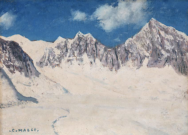
MONT-BLANC DU TACUL PAINTED BY CESARE MAGGI


Cesare Maggi (1881-1961),  Mont-Blanc du Tacul (4,248m -13,937 ft), France, Haute-Savoie,  Alpes, Alpes, Graian Alps Glacier du Géant, Chamonix, France, John Mitchell Gallery, London ,


CESARE MAGGI (1881-1962)
Mont Blanc du Tacul (4,248m -13,937 ft)
France ( Haute-Savoie)

 In Mont Blanc du Tacul seen from the Glacier du Géant, Chamonix, France. oil on panel, 27 x 37cm, courtesy John Mitchell Gallery, London 


The mountain
Mont Blanc du Tacul (4,248m - 13,937 ft) is a mountain in the Mont Blanc massif of the French Alps situated midway between the Aiguille du Midi and Mont Blanc. The Mont Blanc du Tacul looks like a large, snow-covered trapezoid. It is part of the peaks of the Alps over 4,000 meters, of which it is the twenty-fourth highest. To the north of the summit is the Aiguille du Midi, from which it is separated by the Col du Midi (3,532 m), to the south the Mont Maudit, from which it is separated by the Col Maudit (4,035 m), at the is the Aiguilles du Diable then the Glacier du Géant and to the west the Aiguille de Saussure (3,839 m) then the Bossons glacier which rises to its summit. It has a secondary summit, the eastern summit (4,247 m), which is the exit from the Gervasutti pillar. The official first ascent of Mont Blanc du Tacul was by a guideless party comprising Charles Hudson, Edward John Stevenson, Christopher and James Grenville Smith, E. S. Kennedy, Charles Ainslie and G. C. Joad on 8 August 1855. However, Courmayeur guides may have already ascended the peak during their attempts in 1854 and 1855 to force a way up Mont Blanc from the Italian side.

The painter
The italian painter Cesare Maggi was born into a family of actors, Maggi embarked on classical studies at his father’s wish but also took up painting at a very early age His debut in Florence at the Esposizione Annuale della Società di Belle Arti di Firenze in 1898 was followed by a short trip to Paris to catch up with the latest developments.
The crucial turning point in Maggi’s art came in 1889 with the posthumous show of work by Giovanni Segantini held by the Milanese Society of Fine Arts, which prompted a definitive shift to landscape painting of a Divisionist character. After a short stay in the Engadin, he returned to Milan before finally settling in Turin. Commercial collaboration with Alberto Grubicy until 1913 enabled Maggi to establish himself quickly as one of the leading representatives of the second generation of Divisionist painters in Italy. He painted a repertoire of readily comprehensible mountain landscapes focusing primarily on aspects of the visual perception of the reflection of light and colour but lacking the deep spirituality of Segantini’s work. He took part in the major Italian and European exhibitions and the Venice Biennale devoted an entire room to his work at the Esposizione Internazionale d’Arte of Venice in 1912. After an interlude devoted to portrait painting in the same decade, the artist’s mature work focused on greater simplification of subject matter, mostly in landscapes.
Maggi obtained the chair in painting at the Albertina Academy, Turin, in 1936.


___________________________________________
2021- Wandering Vertexes...
by Francis Rousseau

Saturday, March 13, 2021

THE STROMBOLI VOLCANO PAINTED BY ROBINET TESTARD (1480)


ROBINET TESTARD (fl. 1471-1531)
The Stromboli volcano (924 m -3,031 ft)
Italy (Island of Stromboli)

In "Les Iles Eoloiennes"  from  "Secrets de l'Histoire naturelle,  ca.1480-1485, BnF Paris

The mountain
Stromboli  is a small island in the Tyrrhenian Sea, off the north coast of Sicily, containing one of the three active volcanoes (924 m -3,031 ft) in Italy. It is one of the eight Aeolian Islands, a volcanic arc north of Sicily. This name is derived from the Ancient Greek name Strongulē which was given to it because of its round swelling form. The island's population is about 500. The volcano has erupted many times and is constantly active with minor eruptions, often visible from many points on the island and from the surrounding sea, giving rise to the island's nickname "Lighthouse of the Mediterranean". The most recent major eruption was on 13 April 2009. Stromboli stands 926 m (3,034 ft) above sea level, and over 2,700 m (8,860 ft) on average above the sea floor. There are three active craters at the peak. A significant geological feature of the volcano is the Sciara del Fuoco ("Stream of fire"), a big horseshoe-shaped depression generated in the last 13,000 years by several collapses on the northwestern side of the cone. Two kilometers to the northeast lies Strombolicchio, the volcanic plug remnant of the original volcano.
Mt. Stromboli has been in almost continuous eruption for the past 2,000 years. A pattern of eruption is maintained in which explosions occur at the summit craters, with mild to moderate eruptions of incandescent volcanic bombs, at intervals ranging from minutes to hours. This Strombolian eruption, as it is known, is also observed at other volcanoes worldwide. Eruptions from the summit craters typically result in a few short, mild, but energetic bursts, ranging up to a few hundred meters in height, containing ash, incandescent lava fragments and stone blocks. Stromboli's activity is almost exclusively explosive, but lava flows do occur at times when volcanic activity is high: an effusive eruption occurred in 2002, the first in 17 years, and again in 2003, 2007, and 2013–14. Volcanic gas emissions from this volcano are measured by a Multi-Component Gas Analyzer System, which detects pre-eruptive degassing of rising magma, improving prediction of volcanic activity.

The artist
Robinet Testard (fl. 1470–1531) was a French medieval enluminist and painter, whose works are difficult to attribute since none of them was signed or dated. He is known to have worked for the family of Charles, Count of Angoulême (1459–96) in Cognac, and made Valet de Chambre to the family in 1484. When the Count of Angoulême died in 1496, Testard accepted service with the Count's widow, Louise of Savoy, and is mentioned at the time of her death in 1531. Testard started his career in Poitiers.  His works include a page in Le  Missel de Poitiers, the Les Heures de La Rochefoucauld , and two other Books of Hours. His middle period, characterised by tight compositions and sharply defined colouring, is typified by his Roman de la Rose, the Nouailher Missal and the Book of Hours, probably painted for Charles, Count of Angoulême about 1480.  Surprisingly, 17 engravings by Israhel van Meckenem were included in the tome and coloured by Testard. He produced another Book of Hours, a copy of Dioskurides and mythological illustrations after Solinus and Pliny titled Les Secrets de l'histoire naturelle contenant les merveilles et choses memorables du monde (cf. above) . He also illustrated Matthaeus Platearius' "The Book of Simple Medicines".


_______________________________
2021 - Wandering Vertexes...
by Francis Rousseau

Thursday, March 11, 2021

MONTE EPOMEO PAINTED BY SIMON DENIS


https://wanderingvertexes.blogspot.com/2021/03/monte-epomeo-painted-by-simon-denis.html

SIMON DENIS (1755-1813)
Monte Epomeo (789 m - 2,589 ft)
Italy (Ischia Island)

 In Le sommet du mont Epomeo dans l'île d'Ischia, Oil on paper, Musée du Louvre, Paris


The mountain  

Monte Epomeo (789 m - 2,589 ft) is the highest mountain on the volcanic island of Ischia, in the Gulf of Naples, Italy. Epomeo is believed to be a volcanic horst which towers above the rest of Ischia. Much of Epomeo is covered in lush greenery, with a few vineyards also occupying its slopes. Approximately 75 m (246 ft) from the peak the mountain is covered in white lava which may be confused with snow. A path leads to the summit of the mountain from Fontana, one of its quiet traditional villages.


The painter
Simon-Joseph-Alexandre-Clément Denis was a Belgian painter active primarily in Italy. Denis first studied in his native city of Antwerp, with the landscape and animal painter H.-J. Antonissen.
He moved to Paris in the 1780s, and soon gained the patronage of genre painter and art dealer Jean-Baptiste Lebrun, whose support allowed him to move to Rome in 1786. His paintings there attracted favorable attention, and in 1787 he married a local woman. He remained close to the Flemish community in Rome, and in 1789 was elected to head the Foundation St.-Julien-des-Flamands. He also developed ties within the French artistic community; Élisabeth-Louise Vigée-Le Brun stayed with him for some days in 1789 and that same year he and she traveled with François-Guillaume Ménageot to visit Tivoli. François Marius Granet sought his advice when he arrived in Rome in 1802.
In 1803, he was elected to the Accademia di San Luca; in 1806 he settled for good in Naples, becoming court painter to Joseph Bonaparte. His wonderful Landscape near Rome during a Storm (1786–1806) an oil on paper probably representating Monte Cavo as well, is now visible at The MET in New York city.


_______________________________
2021 - Wandering Vertexes...
by Francis Rousseau