google.com, pub-0288379932320714, DIRECT, f08c47fec0942fa0 GRAVIR LES MONTAGNES... EN PEINTURE: CLIFFS
Showing posts with label CLIFFS. Show all posts

Sunday, April 1, 2018

FALAISES D'ETRETAT BY CLAUDE MONET

CLAUDE MONET (1840-1926)
The Falaises d'Etretat (70 to 90 m -  230 to 300 ft)  
France (Normandie) 

 In Régates derriere l'Aiguille d'Etretat, 1885, oil on canvas

The cliffs 
Etretat is best known for its chalk cliffs, including three natural arches and a pointed formation called L'Aiguille (the Needle), which rises 70 m- 230 ft above the sea. The Etretat Chalk Complex, as it is known, consists of a complex stratigraphy of Turonian and Coniacian chalks. Some of the cliffs are as high as 90 metres (300 ft).
L'arche et L'aiguille  (The Ark and the Needle) above. An underground river, then marine erosion formed a natural arch and a estimated 55 meter to 70 meters  high needle, relic piece of the cliff. Maurice Leblanc describes it in these terms in his novel The Hollow Needle (1909) "An enormous roach, more than eighty meters high, colossal obelisk, plumb on its granite base"  At his time, the site already attracted many tourists among them "lupinophiles" admirers of Arsene Lupine: American students came for the key to the cave, where the "gentleman burglar" had found the treasure of kings of France.

The painter 
Oscar-Claude Monet better known as Claude Monet  was a founder of French Impressionist painting, and the most consistent and prolific practitioner of the movement's philosophy of expressing one's perceptions before nature, especially as applied to plein-air landscape painting. The term "Impressionism" is derived from the title of his painting « Impression, soleil levant » (Impression, Sunrise), which was exhibited in 1874 in the first of the independent exhibitions mounted by Monet and his associates as an alternative to the Salon de Paris.
Monet's ambition of documenting the French countryside led him to adopt a method of painting the same scene many times in order to capture the changing of light and the passing of the seasons exactly like the japanese artist  Hokusai (1760-1849) did with his 36 views of Mount Fuji.
Monet has been described as "the driving force behind Impressionism". Crucial to the art of the Impressionist painters was the understanding of the effects of light on the local colour of objects, and the effects of the juxtaposition of colours with each other. Monet's long career as a painter was spent in the pursuit of this aim....

Friday, March 16, 2018

Y LLIWEDD BY SIR KYFFIN WILLIAMS


SIR KYFFIN WILLIAMS (1918-2006) 
Y Lliwedd  (898m- 2, 946ft)
 United Kingdom (Wales)

In Sun and Cloud on Lliwedd, oil on canvas, 1973  
Aberystwyth University School of Art Museum and Galleries 

The mountain 
Y Lliwedd  (898m- 2, 946ft) is a mountain, connected to Mount Snowdon  in the Snowdonia National Park, North Wales. The eastern flanks are steep cliffs rising above Glaslyn and Llyn Llydaw. Y Lliwedd is the most conspicuous of the peaks for those who approach Snowdon via the Miners' and Pyg tracks. Few that summit Snowdon continue over to Y Lliwedd as the challenge of Wales' highest peak is enough, leaving Y Lliwedd quiet and peaceful even when queues are forming at the summit of Snowdon.
Hikers and mountaineers often pass over Y Lliwedd when walking the Snowdon Horseshoe. The noted British climber George Mallory undertook many of his early climbs here. It was also the site of considerable training activity for the 1953 British Everest Expedition.
The north face of Y Lliwedd was explored in the late 19th century and in 1909 was the subject of the first British climbing guide, The climbs on Lliwedd by J. M. A. Thomson and A. W. Andrews.
Two subsidiary peaks of Y Lliwedd are listed as Nuttalls: Lliwedd Bach (818m - 2,699 ft)  and Y Lliwedd East Peak  (893m- 2,947ft)

The Painter 
Sir John "Kyffin" Williams, KBE, RA was a Welsh landscape painter who lived at Pwllfanogl, Llanfairpwll, on the Island of Anglesey. Williams is widely regarded as the defining artist of Wales during the 20th century.
His works typically drew inspiration from the Welsh landscape and farmlands. His works may be seen in a permanent exhibition in the Oriel Kyffin Williams Gallery which opened in 2008 at Oriel Ynys Môn in Llangefni, Anglesey, as well as at many other galleries elsewhere in Britain. He was president of the Royal Cambrian Academy and was appointed a member of the Royal Academy in 1974.
In 1995 Williams received the Glyndŵr Award for an Outstanding Contribution to the Arts in Wales during the Machynlleth Festival. He was awarded the OBE for his services to the arts in 1982 and a KBE in 1999.
The Kyffin Williams Drawing Prize was established in 2009. The winning works from the 2018 prize are due to be exhibited at the Oriel Kyffin Williams Gallery.
In February 2011 it was announced that Williams' paintings of Patagonia would be shown for the first time.  His last passport, on show in the Oriel Ynys Môn gallery at Llangefni, 2004–2014, has the name Sir John Williams. Kyffin was his grandmother's maiden name.
Williams' works are held in many public collections, including the Government Art Collection, the Arts Council Collection and the National Museum of Wales.

Wednesday, January 17, 2018

HOHE ACHT BY CARL FRIEDRICH LESSING


CARL FRIEDRICH LESSING  (1808- 1880) 
Hohe Acht (747m - 2, 450ft) 
 Germany 

1 & 2. In  Landscape in the Eifel Mountains, 1834, Oil on canvas, National Museum of Warsaw, 

The mountain
The Hohe Acht  (747m - 2, 450ft) is the highest mountain in the Eifel mountains of Germany. It is located on the boundary between the districts of Ahrweiler and Mayen-Koblenz in Rhineland-Palatinate. The Hohe Acht is located in the High Eifel east of Adenau. The mountain is a tertiary volcano, whose cone is composed of Lower Devonian rock and whose summit is made of basalt.
Emperor William Tower.
In 1908/09 the Emperor William Tower (Kaiser-Wilhelm-Turm) was erected on the Hohe Acht. The reason for the construction of this stone observation tower, based on plans by the architect, Freiherr von Tettau, Berlin, was the silver wedding of Emperor William II and Empress Augusta Victoria as well as the commemoration of Emperor William I.
The tower is 16.30 metres (53.5 ft) high and its walls are one metre thick at ground level. The work was carried out by master masons, Karl and Johannes Leidinger, from Adenau using local stone. The cost of construction was 18,000 marks. The tower has been a protected monument since 1987.
The Emperor William Tower offers a superb view across the whole Eifel (including the mountains of Scharteberg, Dцhmberg, Michelsberg, Hochthьrmerberg, Schцneberg, the nearby Nьrburg Castle and Hochkelberg), as well as the Siebengebirge and its GroЯer Цlberg and, in conditions of good visibility, as far as the Westerwald, the Taunus, the Hunsrьck and the Lower Rhine.
There is a network of footpaths around the Hohe Acht and, at many places there are good views over the Eifel landscape. In winter the Hohe Acht has some very good winter sport facilities including prepared cross country skiing trails, toboggan runs and ski lifts.

The artist
Carl (or Karl) Friedrich Lessing was a German historical and landscape painter, grandnephew of Gotthold Ephraim Lessing. He was born near Breslau, and was a pupil of Heinrich Anton Dähling at the Berlin Academy. He first devoted himself to landscape. In this period of his artistic career Lessing was influenced by the landscapes of Caspar David Friedrich: his themes he depicted were castle ruins, forgotten cemeteries, rugged rock formations, which he inhabited with figures of monks, knights and thieves. In 1826 obtained a prize with his Cemetery in Ruins. He accompanied Friedrich Wilhelm Schadow to Düsseldorf, where he continued his studies, devoting himself to historical paintings. In 1830, when Schadow went to Italy, Lessing occupied his place as director of the academy, exercising great influence on the Düsseldorf school of painting. His picture Das trauernde Königspaar (Mourning Royal Couple) brought him great popularity. In 1837, he received a gold medal in Paris; he was a member of the Berlin Academy and was the recipient of several orders. In 1858 he was appointed director of the gallery in Karlsruhe, where he continued his activity as a painter until his death in 1880.

Tuesday, January 9, 2018

THE CLIFFS OF ETRETAT BY CLAUDE MONET


CLAUDE MONET (1840-1926),
The Falaises d'Etretat (70 to 90 m -  230 to 300 ft)  
France (Normandie)  

In Les falaises à Etretat 1885, oil on canvas  Clark Institute, Williamstown.

The cliffs 
Etretat is best known for its chalk cliffs, including three natural arches and a pointed formation called L'Aiguille (the Needle), which rises 70 m- 230 ft above the sea. The Etretat Chalk Complex, as it is known, consists of a complex stratigraphy of Turonian and Coniacian chalks. Some of the cliffs are as high as 90 metres (300 ft).
These cliffs and the associated resort beach attracted artists including Eugène Boudin, Gustave Courbet and Claude Monet.  They were featured prominently in the 1909 Arsène Lupin novel The Hollow Needle by Maurice Leblanc. They also feature in the 2014 film Lucy, directed by Luc Besson.
Two of the three famous arches are visible from the town, the Porte d'Aval (Aval Cliff)  and the Porte d'Amont (Amont Cliff).  The Manneporte  (Main Door) is the third and the biggest one, and cannot be seen from the town.
- L'arche et L'aiguille  (The Ark and the Needle)
An underground river, then marine erosion formed a natural arch and a estimated 55 meter to 70 meters  high needle, relic piece of the cliff. Maurice Leblanc describes it in these terms in his novel The Hollow Needle (1909) "An enormous roach, more than eighty meters high, colossal obelisk, plumb on its granite base"  At his time, the site already attracted many tourists among them "lupinophiles" admirers of Arsene Lupine: American students came for the key to the cave, where the "gentleman burglar" had found the treasure of kings of France.
- La porte d'Amont  (Amont Cliff)
The Porte d'Amont is the smallest of the three doors and the most visually famous.  The french writer Guy de Maupassant compares this cliff of upstream to " an elephant that plunges its trunk into the water ". At the top of the cliff stands the stone silhouette of the chapel Notre-Dame-de-la-Garde, protector of fishermen. The present building succeeds a chapel of the nineteenth century. You can also reach the cliff but the staircase is much steeper.  The current building succeeds a 19th century chapel in neo-gothic style.   It was destroyed by the occupier during the Second World War. Then one arrive at the monument and the museum made by the architect Gaston Delaune and dedicated to Charles Nungesser and François Coli, two aviators who tried to rally New York in 1927 and which were seen for the last time in this place, after Having taken off from Le Bourget on the edge of their plane, the mythical White Bird.
The GR 21 long-distance hiking path (Le Havre to Le Tréport) passes through the town.

 The painter 
Oscar-Claude Monet better known as Claude Monet  was a founder of French Impressionist painting, and the most consistent and prolific practitioner of the movement's philosophy of expressing one's perceptions before nature, especially as applied to plein-air landscape painting. The term "Impressionism" is derived from the title of his painting « Impression, soleil levant » (Impression, Sunrise), which was exhibited in 1874 in the first of the independent exhibitions mounted by Monet and his associates as an alternative to the Salon de Paris.
Monet's ambition of documenting the French countryside led him to adopt a method of painting the same scene many times in order to capture the changing of light and the passing of the seasons exactly like the japanese artist  Hokusai (1760-1849) did with his 36 views of Mount Fuji.
Monet has been described as "the driving force behind Impressionism". Crucial to the art of the Impressionist painters was the understanding of the effects of light on the local colour of objects, and the effects of the juxtaposition of colours with each other. Monet's long career as a painter was spent in the pursuit of this aim....
More about Claude Monet's Life and works 

Friday, January 5, 2018

AGHLA MORE / EACHLA MÖR BY PAUL HENRY


 PAUL HENRY (1876-1958) 
Aghla More / Eachla Mör  (584 m -1,916 ft)
Ireland

The mountain 
Aghla More / Eachla Mör  (584 m -1,916 ft) is a mountain in County Donegal, Ireland. The mountain is the third most southern and fourth highest of the mountain chain, called the 'Seven Sisters' by locals (Muckish, Crocknalaragagh, Aghla Beg, Ardloughnabrackbaddy, Aghla More, Mackoght (also known as 'little Errigal') and Errigal. The Seven Sisters are part of the Derryveagh Mountain range.

The painter
Paul Henry was an Irish artist noted for depicting the West of Ireland landscape and particularly landscapes of Achill Island and Connemara in a spare post-impressionist style. Born in Belfast, Ireland, the son of a Baptist minister, Paul Henry began studying at Methodist College Belfast in 1882. During this period he first began drawing regularly. At the age of fifteen he moved to the Royal Belfast Academical Institution. He studied art in Belfast before going to Paris in 1898 to study at the Académie Julian and at Whistler's studio. He married the painter Grace Henry in 1903 and returned to Ireland in 1910. From then until 1919 he lived on , where he learned to capture the peculiar interplay of light and landscape specific to the West of Ireland. In 1919 he moved to Dublin and in 1920 was one of the founders of the Society of Dublin Painters.  In the 1920s and 1930s Paul Henry was Ireland's best known artist, one who had a considerable influence on the popular image of the west of Ireland. Although he seems to have ceased experimenting with his technique after he left Achill and his range is limited, he created a large body of fine images whose familiarity is a testament to its influence. The National Gallery of Ireland held a major exhibition of his work in 2004.
A painting by Paul Henry was featured on an episode of the BBC's Antiques Roadshow, broadcast on 12 November 2006. The painting was given a value of approximately £40,000 - £60,000 by the roadshow. However, due to the buoyancy of the Irish art market at that time, it sold for €260,000 on 5 December 2006 in James Adams' and Bonhams' joint Important Irish Art sale.

Thursday, January 4, 2018

CAP CANAILLE PAINTED BY PAUL SIGNAC


PAUL SIGNAC (1863-1935
Cap Canaille (394 m -1292, 65 ft)
France

The mountain
Cap Canaille (394m) is a cape in France located in the the Provence-Alpes-Côte d'Azur region with a culminating point called " La Grande Tête"  (The great Head). It is located in the city of Cassis, north-west of La Ciotat. Its red rock is composed of detritic limestones. Going into the Mediterranean Sea, it consists of rocky and steep banks dominated by the western extremity of the Soubeyranes cliffs. The latter are, after the Slieve League in Ireland, one of the highest maritime cliffs in Europe and constitute, in La Ciotat, the highest cliffs in France with a maximum altitude of 394 meters. A road, the D141 called "Route des Crêtes", connects Cassis to La Ciotat by approaching the edge of the cliff.  Several gazebos are set up there with a spectacular view on the French Riviera and the sea. Cap Canaille is well known for having inspired a lot of painters of the end of 19th century and beginning of 20th. Its name is due to a distortion of the Provençal langage  Cap Naio  "Cap Naille" in French, meaning "Swimming mountain " or a distorsion of the roman latin name Mons Canalis meaning " Mountain  of Aqueducts".

The painter 
Paul Victor Jules Signac was a French Neo-Impressionist painter who, working with Georges Seurat, helped develop the Pointillist style. In 1884 he met Claude Monet and Georges Seurat. He was struck by the systematic working methods of Seurat and by his theory of colors and became Seurat's faithful supporter, friend and heir with his description of Neo-Impressionism and Divisionism method. Under Seurat's influence he abandoned the short brushstrokes of Impressionism to experiment with scientifically juxtaposed small dots of pure color, intended to combine and blend not on the canvas but in the viewer's eye, the defining feature of Pointillism. Many of Signac's paintings are of the French coast. He loved to paint the water. He left the capital each summer, to stay in the south of France in the village of Collioure or at St. Tropez, where he bought a house and invited his friends.
Paul Signac, Albert Dubois-Pillet, Odilon Redon and Georges Seurat were among the founders of the Société des Artistes Indépendants. The association began in Paris 29 July 1884 with the organization of massive exhibitions, with the device "No jury nor awards". "The purpose of Société des Artistes Indépendants—based on the principle of abolishing admission jury—is to allow the artists to present their works to public judgement with complete freedom". For the following three decades their annual exhibitions set the trends in art of the early 20th century.
Signac himself experimented with various media. As well as oil paintings and watercolors he made etchings, lithographs, and many pen-and-ink sketches composed of small, laborious dots. The Neo-Impressionists influenced the next generation: Signac inspired Henri Matisse and André Derain in particular, thus playing a decisive role in the evolution of Fauvism.
As president of the Société des Artistes Indépendants from 1908 until his death, Signac encouraged younger artists (he was the first to buy a painting by Matisse) by exhibiting the controversial works of the Fauves and the Cubists.

Tuesday, December 12, 2017

TABLE MOUNTAIN PAINTED BY CECIL ARTHUR HUNT


CECIL ARTHUR HUNT (1873-1965)  
Table mountain or Hoerikwaggo (1,085 m - 3,558 ft)  
  South Africa

In Table mountain from Kool Neak, water-colour on paper, 1920 

The mountain 
Table Mountain also called Hoerikwaggo  (1,085 m - 3,558 ft)  is a flat-topped mountain forming a prominent landmark overlooking the city of Cape Town in South Africa and  forming part of the Table Mountain National Park.  The main feature of Table Mountain is the level plateau approximately 3 kilometres (2 mi) from side to side, edged by impressive cliffs. The plateau, flanked by Devil's Peak to the east and by Lion's Head to the west, forms a dramatic backdrop to Cape Town. This broad sweep of mountainous heights, together with Signal Hill, forms the natural amphitheatre of the City Bowl and Table Bay harbour. The highest point on Table Mountain is towards the eastern end of the plateau and is marked by Maclear's Beacon, a stone cairn built in 1865 by Sir Thomas Maclear for trigonometrical survey. It is 1,086 metres (3,563 ft) above sea level, about 19 metres (62 ft) higher than the cable station at the western end of the plateau.
The cliffs of the main plateau are split by Platteklip Gorge ("Flat Stone Gorge"), which provides an easy and direct ascent to the summit and was the route taken by Antуnio de Saldanha on the first recorded ascent of the mountain in 1503.
The flat top of the mountain is often covered by orographic clouds, formed when a south-easterly wind is directed up the mountain's slopes into colder air, where the moisture condenses to form the so-called "table cloth" of cloud. Legend attributes this phenomenon to a smoking contest between the Devil and a local pirate called Van Hunks. When the table cloth is seen, it symbolizes the contest.
Table Mountain is at the northern end of a sandstone mountain range that forms the spine of the Cape Peninsula. To the south of the main plateau is a lower part of the range called the Back Table. On the Atlantic coast of the peninsula, the range is known as the Twelve Apostles. The range continues southwards to Cape PointTable Mountain is featured in the Flag of Cape Town and other local government insignia. It is a significant tourist attraction, with many visitors using the cableway or hiking to the top. 


The painter 
Cecil Arthur Hunt was born in Torquay on 8 March 1873, the son of the highly regarded writer and geologist, Arthur Roope Hunt. He was educated at Winchester and Trinity College, Cambridge, studying Classics and Law, and being called to the Bar in 1899. He treated painting and writing as serious pastimes until 1925, when he was elected to the full membership of the Royal Society of Painters in Water-Colours. He then relinquished his legal career to become a professional painter.
Hunt had first exhibited in 1900, at the Alpine Club Galleries, and had held his first major show a year later, alongside E Home Bruce at the Ryder Gallery. From the first, he established himself as an atmospheric painter of mountains, especially of the Alps and Dolomites. However, he was soon accepted as a master of a great variety of topographies, for he exhibited the products of his wide travels frequently and extensively. Favourite destinations included the West Country, the West Coast of Scotland, the Rhone Valley, Northern Italy, Rome and Taormina. From 1911, until his death, Hunt lived at Mallord House in Chelsea, especially designed for him by Sir Ralph Knott to include a large studio on the ground floor. During the summer months he and his family retreated to the farm estate of Foxworthy, on the edge of Dartmoor.
Hunt showed work regularly at the Royal Academy (from 1912), the Royal Society of British Artists (from 1914) and the Royal Society of Painters in Water-Colours (from 1918). He was elected a member of the RBA in 1914, an associate of the RWS in 1919, and a full member six years later. He acted as the Vice-President of the RWS for a three-year period from 1930. His many substantial solo shows included six at the Fine Art Society (1919-34) and one at Colnaghi’s (1945). Following his death, in 1965,  he was the subject of a large memorial show at the Royal Society of Painters in Water-Colours.
Chris Beetles has done much to revive interest in the work of Cecil Arthur Hunt. He mounted a large scale retrospective exhibition in 1996 at his London gallery, on the exact site of the artist’s first substantial show in 1901. The retrospective was accompanied by a definitive catalogue.

Sunday, November 19, 2017

LES PETITES DALLES PAINTED BY CAMILLE PISSARO


CAMILLE PISSARO  (1830-1903) 
Les Petites Dalles (30 to 50 m - 98 to164 ft)
France 

In Les falaises des Petites Dalles, oil on canvas, 1883, Private collection USA 

The painting 
A lot of impressionist painters choose those cliffs as a item. The most famous was Claude Monet who made at least 10 paintings of those cliffs.  

The mountain 
Les Petites Dalles (30 to 50m - 98 to 164ft) (the Small Slabs) are cliffs located in a hamlet between Sassetot-le-Mauconduit and Saint-Martin-aux-Buneaux, in Haute-Normandie,  France.
Seaside resort south of Dieppe in Normandy, on the coast of the Channel and the country of Caux, the Petites Dalles cliffs are famous mainly because they inspired the impressionist painters like Claude Monet and Berthe Morisot. it is also famous for its numerous seaside villas built at the end of the nineteenth century and preserved (Les Catelets, Les Lampottes, Les Mouettes...)
The old name for Les Petites Dalles appears in the Latinized form Daletis in a charter of 1252.  It is the diminutive of Dalis which appears in the same charter.  Dalis became Les Grandes-Dalles and Daletis, Les Petites Dalles.
The place became definitely up to date in 187,5 when  the Empress of Austria,  Elisabeth, known as Sissi, spent the months of August and September at the castle of Sassetot-le-Mauconduit and regularly bathes on the beach of  Les Petites Dalles. The painter Paul Valantin realizes a painting of the scene. On August 25, 2016, a landslide over a hundred meters of the cliff felt down. Nearly 50,000 m3 of rocks collapsed on the beach in  Saint-Martin-aux-Buneaux at the place known as Les Petites Dalles, according to the Seine-Maritime Fire and Rescue Service.

The Painter
 Camille Pissarro was a Danish-French Impressionist and Neo-Impressionist painter born on the island of St Thomas (now in the US Virgin Islands, but then in the Danish West Indies). His importance resides in his contributions to both Impressionism and Post-Impressionism.
Pissarro studied from great forerunners, including Gustave Courbet and Jean-Baptiste-Camille Corot. He later studied and worked alongside Georges Seurat and Paul Signac when he took on the Neo-Impressionist style at the age of 54.
In 1873 he helped establish a collective society of fifteen aspiring artists, becoming the "pivotal" figure in holding the group together and encouraging the other members. Art historian John Rewald called Pissarro the "dean of the Impressionist painters", not only because he was the oldest of the group, but also "by virtue of his wisdom and his balanced, kind, and warmhearted personality". Cézanne said "he was a father for me. A man to consult and a little like the good Lord," and he was also one of Gauguin's masters. Renoir referred to his work as "revolutionary", through his artistic portrayals of the "common man", as Pissarro insisted on painting individuals in natural settings without "artifice or grandeur".
Pissarro is the only artist to have shown his work at all eight Paris Impressionist exhibitions, from 1874 to 1886. He "acted as a father figure not only to the Impressionists" but to all four of the major Post-Impressionists, including Georges Seurat, Paul Cézanne, Vincent van Gogh and Paul Gauguin.

Monday, August 21, 2017

LES FALAISES D'ETRETAT PAINTED BY GUSTAVE COURBET


GUSTAVE COURBET  (1819-1877)
The Falaises d'Etretat (70 to 90 m -  230 to 300 ft)  
La Porte d'aval, L'Aiguille, La Porte d'Amont, La Manneporte
France (Normandie)  


In Les falaises d'Etretat après l'orage, 1870, oil on canvas, 162cm x130 - 51.2 x 63.8 in,  
Musée d'Orsay Paris  

The cliffs 
Etretat is best known for its chalk cliffs, including three natural arches and a pointed formation called L'Aiguille (the Needle), which rises 70 m- 230 ft above the sea. The Etretat Chalk Complex, as it is known, consists of a complex stratigraphy of Turonian and Coniacian chalks. Some of the cliffs are as high as 90 metres (300 ft).
These cliffs and the associated resort beach attracted artists including Eugène Boudin, Gustave Courbet and Claude Monet.  They were featured prominently in the 1909 Arsène Lupin novel The Hollow Needle by Maurice Leblanc. They also feature in the 2014 film Lucy, directed by Luc Besson.
Two of the three famous arches are visible from the town, the Porte d'Aval (Aval Cliff)  and the Porte d'Amont (Amont Cliff).  The Manneporte  (Main Door) is the third and the biggest one, and cannot be seen from the town.
- La Porte d'Aval (Aval Cliff ) 
On the foreshore cleared by the sea at the foot of the Porte d'Aval, one notices, dug into the limestone bedrock and partially covered with green algae, ancient parks а oysters, whose culture lasted only a few years. 
- L'arche et L'aiguille  (The Ark and the Needle)
An underground river, then marine erosion formed a natural arch and a estimated 55 meter to 70 meters  high needle, relic piece of the cliff. Maurice Leblanc describes it in these terms in his novel The Hollow Needle (1909) : "An enormous roach, more than eighty meters high, colossal obelisk, plumb on its granite base"  At his time, the site already attracted many tourists among them "lupinophiles" admirers of Arsene Lupine: American students came for the key to the cave, where the "gentleman burglar" had found the treasure of kings of France.
- The Manneporte and the Trou à L'homme (The Maindoor and Hole of the man
From the old French manna door, "big door, main door". It is wider than the cliff of Aval and is located behind it. Above а side of the arch, we see a huge black hole in the cliff:  le Trou à l'homme (the Hole of the Man)  that takes its name from a Swedish sailor, sole survivor of the sinking of his ship due to violent storm that would have lasted nearly 24 hours. It would have been projected by a blade into this cavity, thereby assuring its survival. The so called  Hole of the Man is accessible by an iron ladder and it is always off-water at the time of the tides.
The long tunnel which opens to the "Hole of the Man " leads а Creek Petit Port at the mouth of the valleuse Jambourg actually a beach at the foot of the needle and framed by two large doors.
You can reach the top of the cliff by a staircase directly at the end of the Perrey, followed by a well laid out, sloping path that runs alongside the golf course, to the right you climb to the top. One enjoys at the same time, of the sight on the village, on the needle and on Manneporte. You can also enter the little natural refuge nicknamed "Chambre des Demoiselles" ( Young ladies room) described by Maurice Leblanc.
- La porte d'Amont  (Amont Cliff)
The Porte d'Amont is the smallest of the three doors and the most visually famous.  The french writer Guy de Maupassant compares this cliff of upstream to " an elephant that plunges its trunk into the water ". At the top of the cliff stands the stone silhouette of the chapel Notre-Dame-de-la-Garde, protector of fishermen. The present building succeeds a chapel of the nineteenth century. You can also reach the cliff but the staircase is much steeper.  The current building succeeds a 19th century chapel in neo-gothic style.   It was destroyed by the occupier during the Second World War. Then one arrive at the monument and the museum made by the architect Gaston Delaune and dedicated to Charles Nungesser and François Coli, two aviators who tried to rally New York in 1927 and which were seen for the last time in this place, after Having taken off from Le Bourget on the edge of their plane, the mythical White Bird.
The GR 21 long-distance hiking path (Le Havre to Le Tréport) passes through the town.
 Source: 

 The Painter 
Jean Désiré Gustave Courbet was a French painter who led the Realist movement in 19th-century French painting. Committed to painting only what he could see, he rejected academic convention and the Romanticism of the previous generation of visual artists. His independence set an example that was important to later artists, such as the Impressionists and the Cubists. Courbet occupies an important place in 19th-century French painting as an innovator and as an artist willing to make bold social statements through his work.
Courbet's paintings of the late 1840s and early 1850s brought him his first recognition. They challenged convention by depicting unidealized peasants and workers, often on a grand scale traditionally reserved for paintings of religious or historical subjects. Courbet's subsequent paintings were mostly of a less overtly political character: landscapes, seascapes, hunting scenes, nudes and still lifes. He was imprisoned for six months in 1871 for his involvement with the Paris Commune, and lived in exile in Switzerland from 1873 until his death.
Courbet  painted a few mountains in his life : the Juras mountains around Ornans ( France) and a few  mountains in Switzerland during his exil; Like many painters of the 19th Century, Courbet didn't name the mountain he painted; he liked to give a description of the general atmosphere rather than  a precise geographical location.
 "I am fifty years old and I have always lived in freedom; let me end my life free; when I am dead let this be said of me: 'He belonged to no school, to no church, to no institution, to no academy, least of all to any régime except the régime of liberty."

Tuesday, June 6, 2017

SOGNEFJORD PAINTED BY THERESE FUCHS


THERESE FUCHS  (1849-1898)
Sognefjord (1, 306m - 4, 291ft)
 Norway 

In Sommertag im Sognefjord, 1898, oil on canvas,  Private collection 

The mountains 
The Sognefjord or Sognefjorden (1,308 metres -4,291 ft deep) is the largest and best known fjord in Norway and  the deepest in its  central parts near Haeyanger. Located in Sogn og Fjordane county in Western Norway, it stretches 205 kilometres (127 mi) inland from the ocean to the small village of Skjolden in the municipality of Luster. The fjord takes its name from the traditional district of Sogn, which covers the southern part of the county.
The fjord runs through many municipalities: Solund, Gulen, Hyllestad, Hшyanger, Vik, Balestrand, Leikanger, Sogndal, Laerdal, Aurland, Еrdal, and Luster.   Near its mouth, the bottom rises abruptly to a sill about 100 metres (330 ft) below sea level. The seabed in Sognefjord is covered by some 200 metres (660 ft) thick sediments such that the bedrock is some 1,500 metres (4,900 ft) below sea level. The fjord is up to 6 km wide. Cliffs surrounding the fjord rise almost sheer from the water to heights of 1,000 metres (3,300 ft) and more.
The inner end of the Sognefjord is localized southeast of a mountain range rising to about 2,000 metres (6,600 ft) above sea level and covered by the Jostedalsbreen, continental Europe's largest glacier.  Hurrungane range at the eastern end of the fjord reaches 2400 m. The greatest elevation from sea bed to summit is at Sogndal. Several rivers pour fresh water into the fjord with an annual "spring" flood in June.The mouth of the fjord is surrounded by many islands including Sula, Losna, and Hiserшyna.
Boats connect settlements along the fjord and its sidearms. Larger villages on the fjord and its branches include Leirvik, Ytre Oppedal, Vadheim, Hшyanger, Vikшyri, Balestrand, Hermansverk, Sogndalsfjшra, Gudvangen, Flеm, Aurlandsvangen, Laerdalsшyri, Еrdalstangen, Gaupne, and Solvorn. Gudvangen is situated by the Naerшyfjord, a branch of the Sognefjord particularly noted for its unspoiled nature and dramatic scenery, and only 300 metres (980 ft) across at its narrowest point. The Naerшyfjord is a UNESCO World Heritage Site. From the village of Flеm, the Flеm Railway climbs 864 m (2,835 ft) up to Myrdal Station in a distance of only 20 kilometres (12 mi)—the steepest unassisted railway climb in the world.
Around the inner end of the fjord, three of Norway's famous stave churches have survived: Kaupanger and Urnes (along the shoreline) and Borgund (30 kilometres or 19 miles into the Laerdal valley). The Sognefjord Span (power lines) crosses the fjord with a span of 4,597 metres (15,082 ft). This is the second largest span of power lines in the world. The fjord has become a tourist attraction with summer tourists being an important part of the local economy.

The painter 
Therese Fuchs was a German artist of the Dusseldorf School of Painting  who is known to have lived in Norway for a considerable time.  A prolific painter, she created atmospheric works depicting Alpine scenes, fiords, lakes and snowy landscapes, signing her work 'Th. Fuchs'. Many sources give her date of death as 1898 but this may be the year of her last dated painting as other sites state 'after 1898'. ​In the Getty Library Repository there is a letter from Therese Fuchs, dated 1901, sent to the German artist Melchior Lechter which might prove she was still alive in 1901...
Between 1819 and 1918, some 4000 artists belonged to the Düsseldorf school of painting, a school which  had a significant influence on the Hudson River School in the United States.  Albert Bierstadt applied but was not accepted.  His American friend Worthington Whittredge became his teacher while attending Düsseldorf.

Monday, May 22, 2017

BLACKHEAD, MONHEGAN PAINTED BY EDWARD HOPPER


EDWARD HOPPER (1882-1967)
Blackhead (50 m-150 ft) 
United States of America (Maine)

1. In Blackhead, Monhegan, 1916-19,oil on wood, Whitney Museum of American Art, 


The mountain 
Blackhead (50m-150 ft) are northside cliffs situated on Monhegan, Manana Island, that have drawn the interest of  many artists.  The beginnings of the art colony on Monhegan date to the mid-19th century; by 1890, it was firmly established. Two of the early artists in residence from the 1890s, William Henry Singer (1868–1943) and Martin Borgord (1869–1935), left Monhegan to study at the Académie Julian in Paris in 1901. Among many early members who found inspiration on the island were summer visitors from the New York School of Art and the Pennsylvania Academy of the Fine Arts, such as Robert Henri, Frederick Waugh, George Bellows, Edward Hopper and Rockwell Kent. The Monhegan Museum celebrated more the continuing draw of the island for artists in a 2014 exhibit entitled, “The Famous and the Forgotten: Revisiting Monhegan’s Celebrated 1914 Art Exhibition.
Monhegan is a plantation in Lincoln County, Maine, United States, about 12 nautical miles (22 km) off the mainland. The population was 75 at the 2000 census. The plantation comprises its namesake island and the uninhabited neighboring island of Manana. The island is accessible by scheduled boat service from Boothbay Harbor, New Harbor and Port Clyde. It was designated a National Natural Landmark for its coastal and island flora in 1966.[
The name Monhegan derives from Monchiggon, Algonquian for "out-to-sea island." European explorers Martin Pring visited in 1603, Samuel de Champlain in 1604, George Weymouth in 1605 and Captain John Smith in 1614. The island got its start as a British fishing camp prior to settlement of the Plymouth Colony. Cod was harvested from the rich fishing grounds of the Gulf of Maine, then dried on fish flakes before shipment to Europe. A trading post was built to conduct business with the Indians, particularly in the lucrative fur trade.  It was Monhegan traders who taught English to Samoset, the sagamore who in 1621 startled the Pilgrims by boldly walking into their new village at Plymouth and saying: "Welcome, Englishmen." 

The painter
Edward Hopper was a American realist painter and printmaker.
Conservative in politics and social matters (Hopper asserted for example that "artists' lives should be written by people very close to them"), he accepted things as they were and displayed a lack of idealism. Cultured and sophisticated, he was well-read, and many of his paintings show figures reading. He was generally good company and unperturbed by silences, though sometimes taciturn, grumpy, or detached. He was always serious about his art and the art of others, and when asked would return frank opinions.
Hopper's most systematic declaration of his philosophy as an artist was given in a handwritten note, entitled "Statement", submitted in 1953 to the journal, Reality:
"Great art is the outward expression of an inner life in the artist, and this inner life will result in his personal vision of the world. No amount of skillful invention can replace the essential element of imagination. One of the weaknesses of much abstract painting is the attempt to substitute the inventions of the human intellect for a private imaginative conception.
The inner life of a human being is a vast and varied realm and does not concern itself alone with stimulating arrangements of color, form and design.
The term life used in art is something not to be held in contempt, for it implies all of existence and the province of art is to react to it and not to shun it.
Painting will have to deal more fully and less obliquely with life and nature's phenomena before it can again become great."
- More about Edward Hopper

Sunday, May 14, 2017

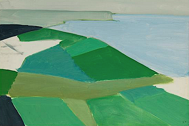
CAP BLANC-NEZ & CAP GRIS-NEZ BY NICOLAS DE STAËL

http://wanderingvertexes.blogspot.com


http://wanderingvertexes.blogspot.com

 NICOLAS DE STAËL (1914-1955)
Cap Blanc-Nez (151m - 495ft)
 Cap Gris-Nez (45m -148ft) 
France

1. In Cap Blanc Nez, 1954, oil on canvas. Private Collection 
2. In Cap Gris Nez, 1954, oil on canvas. Private Collection  

The Mountain 
Cap Blanc-Nez (151m - 495ft) (Cape White Nose) is a cape on the Côte d'Opale, in the Pas-de-Calais, in northern France. The cliffs of chalk are very similar to the white cliffs of Dover at the other side of the Channel in England. Cap Blanc-Nez does not protrude into the sea like a typical cape, but is a high point where a chalk ridge has been truncated by the sea, forming a cliff that is topped by the obelisk of the Dover Patrol Monument, commemorating the Dover Patrol which kept the Channel free from U-boats during World War II. Cap Blanc- Nez was a vital measuring point for the eighteenth-century trigonometric survey linking the Paris Observatory with the Royal Greenwich Observatory. Sightings were made across the English Channel to Dover Castle and Fairlight Windmill on the South Downs. This Anglo-French Survey was led in England by General William Roy.
Cap Gris Nez (45 m -148 ft) is situated some miles away to the southwest of Cap Blanc-Nez.  It is between Wissant and Audresselles, in the commune of Audinghen. The cliffs of the cape are the closest point of France to England – 34 km (21 mi) from their English counterparts at Dover. Smothered in sea pinks and thrift, the cliffs are a perfect vantage point to see hundreds of ships, from oil tankers to little fishing trawlers, plying the waters below. On a clear day, the white cliffs of Dover on the English shore can be seen. The proximity of the cape to England led to the frequent destruction of the nearby village of Audinghen in wars between England and France. On the top of the cliff are the ruins of an English fortress, built by Henry VIII at the beginning of the 16th century. 
Nowadays, as a Natura 2000 site, Cap Gris-Nez is considered as a major site of pan-European importance to be protected both for the conservation of remarkable natural habitats and for migrations of avifauna. Cap Gris-Nez is very frequented by ornithologists during the birds migrations periods (spring, autumn).
The both capes (Blanc-Nez and Gris-Nez) are declared Grands sites de France since 2011 et constitutes the Grand Site Des Deux Caps (Grand Site Of Two Caps),  emblematic of the Parc regional de Caps et Marais d’Opale.

The Painter 
Nicolas de Staël was a French painter of Russian origin known for his use of a thick impasto and his highly abstract landscape painting. Nicolas de Staël was born Nikolai Vladimirovich Stael von Holstein (Николай Владимирович Шталь фон Гольштейн) in Saint Petersbourg (Russia), into the family of a Baron Vladimir Stael von Holstein, the last Commandant of the Peter and Paul Fortress. De Staël's family was forced to emigrate to Poland in 1919 because of the Russian Revolution ; both his father and stepmother died in Poland and the orphaned Nicolas de Staël was sent with his older sister Marina to Brussels to live with a Russian family (1922)...
- More about Nicolas de Stael biography 

2017 - Wandering Vertexes...
by Francis Rousseau 

Sunday, April 30, 2017

MONTE SOLARO PAINTED BY ASCAN LUTTEROTH


ASCAN LUTTEROTH (1842-1923)
Monte Solaro (589m - 1,932ft)
Italy (Campania) 

In Capri and Monte Solaro from a boat,  1923, oil on canvas
  In Capri and Monte Solaro from Punta Campanella, 1922, oil on canvas 

The mountain 
Monte Solaro (589m - 1,932ft)  also called Monte Solare or Monte Solara is the highest point of  the island of Capri in Campania, in the Gulf of Naples, Italy.  Monte Solaro is formed from the same limestone that the island is composed of. Monte Solaro has a typical mediterranean climate, but with colder winters because of the high altitude. From the top of Monte Visto, one can see both the gulfs of Napoli and Salerno.
The summit is accessible by walking without too much difficulty by either the passetiello or a path that starts from Axel Munthe. Both routes are suitable for walkers in decent physical condition. Notable sites include the Eremo di Santa Maria a Cetrella for its architecture, and the remains of the Fortino di Bruto, a military fort built during the Napoleonic Wars.
Mount Solaro contains the "Fortino di Bruto", a blockhouse which was used in battles between Britain and France in the early 19th century.  It is characterised by its "sheer dolomitic slopes" which form an "unsurpassable partition" between the eastern and western sides of the island. 
Marina Grande lies at the foot of the mountain. It became popular with painters due to its "romantic situation, affording extensive and beautiful views to the NW of the Tyrrhenian sea, the gulf of Naples". Up the mount there is a statue of Emperor Augustus who first landed on Capri.
The area around Monte Solaro is inhabited by over 900 species of vegetation.  The mountain is also visited by many species of birds, including peregrine falcons.

The Painter 
Ascan Lutteroth  was a German landscape painter,  son of the banker Christian Alexander Ascan Lutteroth. He studied from 1861 with Alexandre Calame in Geneva and 1864 to 1867 with Oswald Achenbach in Düsseldorf. From 1868 to 1870 he lived in Italy, he went and live in Capri for a while, before going to  Berlin until 1877. Crown Prince Frederick William and Crown Princess Victoria greatly appreciated him. In 1879 they took him on their journey to San Remo and Lutteroth became the teacher of the Crown Princess. In 1890 Wilhelm II gave him the official title of professor. He is regarded as the most important Hamburg landscape painter of his time. Until 1909 he was chairman of the Hamburg artist 's workshop of 1832. Among the 91 paintings and 32 watercolors he produced, Lutteroth mainly painted landscapes from Italy and the Hamburg area, alpine and forest scenes, sparingly populated with small figures. His works were represented in the major national and international exhibitions, including in the Berlin National Gallery, the Rudolfinum Prague, and the Magdeburg Gallery.  Today the Hamburger Kunsthalle, the Anhaltische Gemäldegalerie Dessau in the Georgian Palace,  the Museumberg Flensburg, the Städtische Galerie Rosenheim and the Museum Villingen-Schwenningen have pictures by him. In the Leipzig Museum, there was a painting of the Mawensi (East Summit of Kilimanjaro) depicting Lutteroth in 1889, with the African farmer and researcher Hans Meyer. Donated to the Museum Leipzig Museum in 1890 by  J. Meyer, this work has been lost since the Second World War.

Friday, April 28, 2017

DIE LORELEI BY NIKOLAÏ ASTUDIN


NIKOLAÏ ASTUDIN (1847-1925) 
Die Loreley (132m - 433ft)
Germany 

Engraving from an oil on canvas, 1910

The mountain 
Die Loreley  (132m- 433 ft) high  is a slate cliff in the Upper Middle Rhine Valley World Heritage near the town of St. Goarshausen. The view of St. Goarshausen, from the Loreley outlook point, with Castle Katz and the view of the town St. Goar and its Fortress Rheinfels, leaves a wonderful impression on all Loreley tourists. The Rhine, at the Loreley, is up to 82 feet deep and only 371 feet wide. Because this area is so deep and narrow, it is one of the most dangerous places in the World Heritage Upper Middle Rhine Valley. Ships, crossing each other here and all along the section between Oberwesel and St. Goarshausen, are directed by light signals, called “Wahrschau”.
The name comes from the old German words lureln, Rhine dialect for "murmuring", and the Celtic term ley ("rock"). The translation of the name would therefore be: "murmur rock" or "murmuring rock". The heavy currents, and a small waterfall in the area (still visible in the early 19th century) created a murmuring sound, and this combined with the special echo the rock produces to act as a sort of amplifier, giving the rock its name. The murmuring is hard to hear today owing to the urbanization of the area. Other theories attribute the name to the many accidents, by combining the German verb "lauern" (to lurk, lie in wait) with the same "ley" ending, with the translation "lurking rock".
In the German language orthographic reform of 1903, in almost all German terms the letter "y" was changed to the letter "i".
The rock and the murmur it creates have inspired various tales. An old legend envisioned dwarfs living in caves in the rock. The Lorelei have inspired as well quite a lot of artists, musicians and painters and poets, the most famous of them being Heinrich Heine (link  to the full poem here)

 The painter 
Nikolai Lvovoch Astudin ( Николай Львович Астудин)  was a Russian landscape painter.
Astudin was the son of an officer and completed his school education in Saint Petersburg. He then became a student of the landscape painter Armand-Théophile Cassagne (1823-1907) in Paris. Study trips lead him to Finland, to the Alpine countries and to Italy. As early as 1876 and 1877 Astudin had exhibitions in Berlin,  and in 1885 in Zurich.  Among his Bonner motifs are the Rhine Bridge (1898) and the Godesburg. In 1912, he moved to Oberlahnstein, where he lived until his death. In this late phase, he mainly painted the Rhine motifs and repeatedly painted Lahneck Castle and The Lorelei (above).  Astudin was widely known for his Rhine paintings and the numerous reproductions of his Rhine views. His work is an expression of the Rhine and Eifelromantik of the early 20th century.

_______________________________
2017 - Wandering Vertexes...
by Francis Rousseau 

Wednesday, April 26, 2017

PENYCADAIR PAINTED BY RICHARD WILSON


RICHARD WILSON (1714-1782)
Penygadair - Cader Idris (892m-2,927ft)
United Kingdom (Wales)

1.   In Llyn-y-Cau, Cader Idris, oil on canvas, Tate Britain 
2. In The Mawddach Valley and Cader Idris, 1774, oil on canvas, Walker Art Gallery 

The mountain 
 Penygadair or Pen-y-Gader (892m-2,927 ft ) which means Top of the Chair, is the summit of Cader  Idris mountain and offers a superb panorama of mountain scenery.  Cader Idris  (or Cadair Idris) means 'Chair of Idris', the giant warrior poet of Welsh legend.  The mountain consists of a long ridge (11km), the 19th highest mountain in Wales and the second most popular mountain in the country after Mount Snowdon.  Pen-y-Gader northern face is craggy and precipitous, in contrast to the south face which slopes more gently into the broad expanse of the Dyfi estuary. There are a number of paths which lead to the summit, the Fox's Path leads directly up the mountains north face. To the north of the summit lies the very steep and craggy north face, where the cliffs drop around 200 metres (656ft).  The other peaks of the ridge are Mynyyd Moel (855m- 2805ft) and Mynydd Pencoed (798m-2618ft). North of Cadair Idris lies the town of Dolgellau, a convenient base, which offers cafes, restaurants and shops. The mountain is notorious for its low cloud but on a clear day it is possible to see the mountains of the Snowdon massif and the Rhinog mountain range as well as the Lleyn Peninsula and the hills of Shropshire, the Long Mynd, the Wrekin and occasionally Ireland.
There are numerous legends about Cader Idris. Some nearby lakes are supposed to be bottomless, and anyone who sleeps on its slopes alone will supposedly awaken either a madman or a poet. The tradition of sleeping on the summit of the Mountain apparently stems from bardic traditions, where bards would sleep on the mountain in hope of inspiration.
 Source:
 -Snowdonia official  Guide 

The painter
Richard Wilson was an influential Welsh landscape painter, who worked in Britain and Italy. With George Lambert he is recognized as a pioneer in British art of landscape for its own sake and was described in the Welsh Academy Encyclopedia of Wales as the "most distinguished painter Wales has ever produced and the first to appreciate the aesthetic possibilities of his country".  From 1750 to 1757 Wilson was in Italy, and became a landscape painter on the advice of Francesco Zuccarelli. Painting in Italy and afterwards in Britain, he was the first major British painter to concentrate on landscape. He composed well, but saw and rendered only the general effects of nature, thereby creating a personal, ideal style influenced by Claude Lorrain and the Dutch landscape tradition. John Ruskin wrote that Wilson "paints in a manly way, and occasionally reaches exquisite tones of colour". Among Wilson's pupils was the painter Thomas Jones. His landscapes were acknowledged as an influence by Constable, John Crome and Turner.
In December 1768 Wilson became one of the founder-members of the Royal Academy. A catalogue raisonné of the artist's work is published by the Paul Mellon Centre for Studies in British Art.
Source: 
- Tate Britain 

Tuesday, April 25, 2017

MONT PUGET - LES CALANQUES BY LUCIEN LEVY DHURMER


LUCIEN LEVY-DHURMER (1865-1953)
Mont Puget (563m - 1,847ft)
France (Provence-Alpes-Côte-d'Azur) 

1. In Mont Puget, Calanques (6 heures du soir),1930-36, oil on canvas, Musée d'Orsay, Paris 
2. In Mont Puget, Les Calanques (midi) , 1930-36, oil on canvas,  Musée d'Orsay, Paris  
3. In Les Calanques (lever de soleil), pastel, Musée d'Orsay, Paris 

The mountain
Mount Puget (563m - 1,847ft) is the highest point of the Massif des Calanques, between Marseille (northwest) and Cassis (east). It lies to the east of the massif Marseilleveyre. Overlooking the city, which spreads at its feet, it offers a unique view on the harbors North and South of Marseille. Puget is the diminutive of the Provencal word "puech" which comes from the Latin "podium" and designates an eminence, a high place.
Mount Puget can provide interesting climbing and walking routes. The most common starting point is the Luminy faculty site at the bus terminal. A very good track, which has been set up for the firemen, leads to the summit in about two hours. One can also climb directly through several "ways". One of these is actually a scree, with a slope of 45 degrees. From the summit, you have a panorama of the Grande Candelle, the Calanques, Cap Canaille, the city of Marseille, the Garlaban massif, and even the Sainte-Baume Massif.
The Massif of the Calanques (also know as Calanques of Marseille), are a massive coastline, extending over twenty kilometers of coast on the Mediterranean Sea between the village of La Madrague (district of the south-west of the city of Marseille) to Cassis, via Les Goudes and Callelongue. It is one of the most remarkable natural sites in France, and a major natural resource area for its one million annual visitors. The word calanque (Provencal Calanco) refers to a valley dug by a river and then recovered by the sea. The Calanques benefit from the protection of the National Park of the Calanques created in April 2012 and which is the first national peri-urban park in Europe. In order to repopulate the waters, certain areas of the future park are forbidden to fish to serve as natural nurseries.

The Painter 
Lucien Lévy-Dhurmer  was a French Symbolist/Art Nouveau artist whose works include paintings, drawings, ceramics, furniture and interior design.
He was born Lucien Lévy to a Jewish family in Algiers, Algeria in those days a French colony. In 1879 he began studying drawing and sculpture in Paris. He first exhibited at the Paris Salon of 1882 where he showed a small ceramic plaque. In 1887 Lévy began making his living near Cannes in southern France, overseeing the decoration of ceramics. From 1886 to 1895 he worked as a ceramic decorator and then as artistic director of the studio of Clément Massier. Around 1892 he signed his first pieces of ceramics, which were influenced by Islamic Art.  In 1895 he left for Paris to begin a career in painting; around this time he visited Italy and was further influenced by art of the Renaissance. In 1896 he exhibited his first pastels and paintings under the name Lucien Lévy-Dhurmer; he'd added the last two syllables of his mother's maiden name (Goldhurmer), likely to differentiate himself from other people named Lévy. His paintings soon became popular with the public and among fellow artists as well. He earned high praise for the academic attention to detail with which he captured figures lost in a Pre-Raphaelite haze of melancholy, contrasted with bright Impressionist colouration. His portrait of writer Georges Rodenbach is perhaps the most striking example of this strange and extraordinary synergy.
After 1901 Lévy-Dhurmer moved away from expressly Symbolist content, incorporating more landscapes into his work because of his travels in Europe and North Africa. He continued to draw inspiration from music and attempted to capture works of great composers such as Beethoven in painted form.

Sunday, April 23, 2017

LES PETITES DALLES PAINTED BY CLAUDE MONET


CLAUDE MONET (1840-1926)
 Les Petites Dalles (30 to 50m - 98 to164ft)
 France 

1. In  Marée basse aux Petites Dalles, 1884, oil on canvas, Private collection 
 2.  In La falaise des petites dalles en 1884,  oil en canvas, Kreeger Museum, Washington DC
3. In La falaise d'Amont, 1881, oil on canvas, Private collection 
 4.  In Falaise près de Dieppe, 1882, oil on canvas, Private collection 
5.  In Falaises des Petites Dalles, 1880, oil on canvas,  Museum of Fine Arts, Boston 


Claude Monet and Les Petites  Dalles 
Claude Monet first came to Les Petites-Dalles for a fortnight in September 1880. He then returned regularly for seven years, from 1881 to 1886. He went down to his brother Léon who lived in one of the villas Saint-Jean. Léon (Léon Pascal Monet domiciled in Rouen) bought this villa, or rather the land, on Aug. 9, 1875. At least 10 paintings (oil on canvas) were painted at Les Petites-Dalles by Claude Monet:  2 in 1880, 4 in 1881 and 4 in 1884. All but one of 1884 represent the cliffs.

The mountain 
Les Petites Dalles (30 to 50m - 98 to 164ft) (the Small Slabs) are cliffs located in a hamlet between Sassetot-le-Mauconduit and Saint-Martin-aux-Buneaux, in Haute-Normandie,  France.
Seaside resort south of Dieppe in Normandy, on the coast of the Channel and the country of Caux, the Petites Dalles cliffs are famous mainly because they inspired the impressionist painters like Claude Monet and Berthe Morisot. it is also famous for its numerous seaside villas built at the end of the nineteenth century and preserved (Les Catelets, Les Lampottes, Les Mouettes...)
The old name for Les Petites Dalles appears in the Latinized form Daletis in a charter of 1252.  It is the diminutive of Dalis which appears in the same charter.  Dalis became Les Grandes-Dalles and Daletis, Les Petites Dalles.
The place became definitely up to date in 187,5 when  the Empress of Austria,  Elisabeth, known as Sissi, spent the months of August and September at the castle of Sassetot-le-Mauconduit and regularly bathes on the beach of  Les Petites Dalles. The painter Paul Valantin realizes a painting of the scene. On August 25, 2016, a landslide over a hundred meters of the cliff felt down. Nearly 50,000 m3 of rocks collapsed on the beach in  Saint-Martin-aux-Buneaux at the place known as Les Petites Dalles, according to the Seine-Maritime Fire and Rescue Service.
 Source: 
lespetitesdalles official website  (in French)

 The painter 
Oscar-Claude Monet better known as Claude Monet  was a founder of French Impressionist painting, and the most consistent and prolific practitioner of the movement's philosophy of expressing one's perceptions before nature, especially as applied to plein-air landscape painting. The term "Impressionism" is derived from the title of his painting « Impression, soleil levant » (Impression, Sunrise), which was exhibited in 1874 in the first of the independent exhibitions mounted by Monet and his associates as an alternative to the Salon de Paris.
Monet's ambition of documenting the French countryside led him to adopt a method of painting the same scene many times in order to capture the changing of light and the passing of the seasons exactly like the japanese artist  Hokusai (1760-1849) did with his 36 views of Mount Fuji.
Monet has been described as "the driving force behind Impressionism". Crucial to the art of the Impressionist painters was the understanding of the effects of light on the local colour of objects, and the effects of the juxtaposition of colours with each other. Monet's long career as a painter was spent in the pursuit of this aim....
More about Claude Monet's Life and works 
 
___________________________________________

2017 - Wandering Vertexes...
by Francis Rousseau


Sunday, April 16, 2017

CAP DE CREUS PAINTED BY SALVADOR DALI


SALVADOR DALI (1904-1989) 
Cap de Creus (672 m  - 2, 205ft)

 Spain 

1. In The Persistence of Memory, 1931, oil on canvas, MOMA, New York
2. In Untitled Persistence of Fair Weather, oil on canvas, Salvador Dali Museum,  St Pertersburg FL 
3. In Le Spectre du Sex Appeal, 1934, oil on canvas, Fundació Gala-Salvador Dalí, Figueres, Spain
4. In The Disintegration of the Persistence of Memory, 1952-54, oil on canvas, 

The mountain 
Cap de Creus (672 m  - 2, 205ft) is a peninsula and a headland located at the far northeast of Catalonia (Spain), some 25 kilometres (16 mi) south from the French border. The cape lies in the municipal area of Cadaquès, and the nearest large town is Figueres, capital of the Alt Empordа and birthplace of Salvador Dali.  Cadaquès is the most well known village, home of artists and writers, with sophisticated atmosphere, near Port Lligat where Dali built his home in a paradise small bay. (Dalн depicted Cap de Creus in four of his most famous paintings : The Persistence of Memory  in 1931 (above), Untitled (Persistence of Fair Weather) 1932-34 (above),  Le Spectre du sex appeal in 1934 (above) and the The Disintegration of the Persistence of Memory, 1952-54 (above) 
Cap de Creus is the easternmost point of Catalonia and therefore of mainland Spain and the Iberian Peninsula.  Mountains are the eastern foothills of the Pyrenees, the natural border between France and Spain.  The peninsula has an area of 190 square kilometres (73 sq mi) of an extraordinary landscape value; a windbeaten very rocky dry region, with almost no trees, in contrast with a seaside rich in minuscule creeks of deep blue sea to anchor.The region is frequently swept by awful north wind "tramontana" (beyond mountains) which has caused many naval disasters.
Sant Pere de Rodes stands out at 500 metres (1,600 ft) of altitude, with views of the Cap and the Pyrenees. It is an 11th-century monastery whose first structures date from about 750 AD.
One legend tells that the Cap de Creus was hewn by Hercules.
Source: 

 The painter 
Salvador Domingo Felipe Jacinto Dalí i Domènech, Marqués de Dalí de Púbol, known professionally as Salvador Dalí, was a prominent Spanish surrealist painter born in Figueres, Catalonia, Spain.
Dalí was a skilled draftsman, best known for the striking and bizarre images in his surrealist work. His painterly skills are often attributed to the influence of Renaissance masters. His best-known work,  The Persistence of Memory (above) was completed in August 1931. Dalí's expansive artistic repertoire included film, sculpture, and photography, in collaboration with a range of artists in a variety of media. Dalí attributed his "love of everything that is gilded and excessive, my passion for luxury and my love of oriental clothes" to an "Arab lineage", claiming that his ancestors were descended from the Moors. Dalí was highly imaginative, and also enjoyed indulging in unusual and grandiose behavior. His eccentric manner and attention-grabbing public actions sometimes drew more attention than his artwork, to the dismay of those who held his work in high esteem, and to the irritation of his critics.
Sources :
- MOMA, New York 
- Series of video portraits and interviews