google.com, pub-0288379932320714, DIRECT, f08c47fec0942fa0 GRAVIR LES MONTAGNES... EN PEINTURE: ANDES
Showing posts with label ANDES. Show all posts

Sunday, March 21, 2021

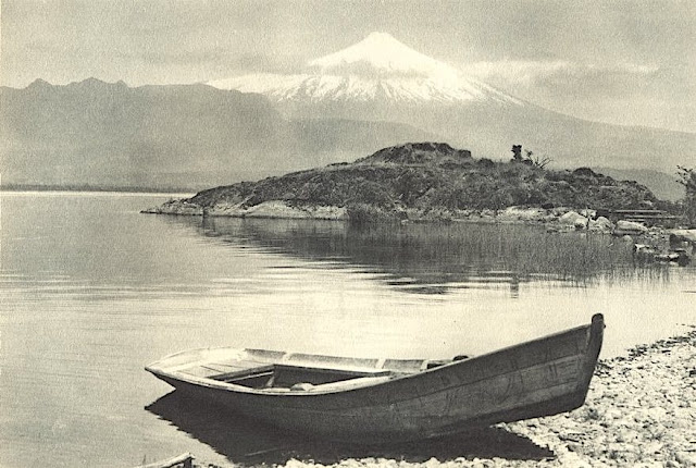
VOLCÀN ORSONO PHOTOGRAPHED BY ROBERT GERSTMANN


https://wanderingvertexes.blogspot.com/2021/03/volcan-orsono-photographed-by-robert.html

ROBERT GERSTMANN (1896-1960)
Volcàn Orsono (2,652 m - 8700 ft)
Chile

in Lago Villarrica e Volcan Orsono, photo, 1932


The volcano
The Osorno is a stratovolcano located between the province of Osorno and that of Llanquihue, in the Lakes region of Chile. At an altitude of 2,652 meters, it is the most active volcano in the southern Chilean Andes.  It rises to the east of Lake Llanquihue, known worldwide as a symbol of the local landscape. The volcano also dominates Lake Todos los Santos. Its last eruption dates from 1869. Charles Darwin saw the Osorno from afar on his second voyage on HMS Beagle and witnessed its eruption1 in January 18352. Its first ascent was made in 1848 by Jean Renous.

The photographer
Robert Gerstmann was a photographer very famous in South America. Gerstmann was a Vienna born electrical engineer who, as a young man, developed an interest in photography. In 1924, he immigrated to Chile and from there traveled to Bolivia, where he made some 5000 photographs, a selection of which appear as photogravures in his Bolivia, 150 Grabados en Cobre (1928), which was reissued in 1996 by the Fundación Quipus in La Paz. Gerstmann ranged far, photographing the altiplano from La Paz south to the Argentine border, west to the Chilean border, and east to the Yungas, Cochabamba, Santa Cruz, and the lowlands along the Ríos Beni and Mamoré. Only Tarija and the Chaco escaped his lens. Five of his photographs illustrate Stewart E. McMillan's "The Heart of Aymara Land" National Geographic Magazine (February 1927), and several appear in Gustavo-Adolfo Otero's Bolivia (Guía Sinóptica) 1929. Gerstmann settled in Santiago in 1929. He published other photo albums, including Chile: 280 grabados en cobre (1932), Colombia: 200 grabados en cobre (1951), and Chile en 110 cuadros (1960?), and dabbled in film-making in Bolivia. He is thought to have died in Santiago ca. 1960. Several thousand of his glass plates are said to be at a university in Antofagasta. 


_______________________________
2021 - Wandering Vertexes...
by Francis Rousseau

Saturday, August 8, 2020

EL TUPUNGATO PAINTED BY RAMOS CATALAN


RAMOS CATALAN ( 1888-1961)
El Tupungato (6,635 m - 21,768 ft ) 
Chili Argentina border

 In Tupungato at sunset, oil on canvas, 1930, Valparaiso Fine Art Museum, Chile

The volcano
Tupungato (6,635m -  one of the highest mountains in the Americas, is a massive Andean lava dome dating to Pleistocene times.  It lies on the border between the Chilean Metropolitan Region (near a major international highway about 80 km (50 mi) east of Santiago) and the Argentine province of Mendoza, about 100 km (62 mi) south of Aconcagua, the highest peak of both the Southern and Western hemispheres. Immediately to its southwest is the active Tupungatito volcano (literally, little Tupungato), which last erupted in 1987.
Tupungato Department, an important Argentine wine-producing region in Mendoza province, is named for the volcano.

The painter
Benito Ramos Catalán (1888-1961) was a chilean painter who used to sign "Ramos Catalan". Known for his marines and landscapes of the Andes and Chile, and most particularly for his mountains paintings. Most of them have the same title: "Mountains of Chile" or "Mountains landscapes of Andes", making quite difficult to know which mountain was exactly depicted, in a country which has quite a lot of summits ! To add to the difficulty, he used to paint the most famous mountains of his country under very unusual angles or with proportions that do not correspond exactly to their real size... making even more difficult to recognize and identify them for experts ! That is why today, 55 years after his death, some of these mountains paintings are not clearly identified and presented, in the public sales, as 'possibly' a particular summit of Chile or Andes...
His works are in many Chilean institutions like Viña del Mar Fine Art Museum, O'Higginiano Fine Art Museum in Talca, Valparaiso Fine Art Museum, and Navy Schools in Valparaiso and Talcahuano, Ranos.

__________________________________________

2020 - Wandering Vertexes...
by Francis Rousseau


Wednesday, July 1, 2020

TOIRRES DEL PAINE PAINTED BY JAMES HART DYKE


JAMES HART DYKE (bn.1966)
Torres del Paine (2,500 m - 8,200 ft) 
Chile 
In Torres del paine and single cloud, oil on vanvas 2018, courtesy John Mitchell Gallery

The mountains
The Torres del Paine  (2,500 metres - 8,200 ft)  are the distinctive three granite peaks of the Paine mountain range or Paine Massif. They are known as Torres d'Agostini, Torres Central and Torres Monzino. They  are joined by the Cuernos del Paine. The area also boasts valleys, rivers such as the Paine, lakes, and glaciers. The well-known lakes include Grey, Pehoé, Nordenskiöld, and Sarmiento. The glaciers, including Grey, Pingo and Tyndall, belong to the Southern Patagonia Ice Field.
he landscape of the park is dominated by the Paine massif, which is an eastern spur of the Andes located on the east side of the Grey Glacier, rising dramatically above the Patagonian steppe. Small valleys separate the spectacular granite spires and mountains of the massif. These are: Valle del Francés (French Valley), Valle Bader, Valle Ascencio, and Valle del Silencio (Silence Valley).
The Southern Patagonian Ice Field mantles a great portion of the park.

The painter
James Hart Dyke’s work is centred on landscape painting, from the domesticity of paintings of country houses to paintings generated from physically demanding expeditions over remote mountains. James has also undertaken a series of projects including accompanying HRH The Prince of Wales as the official artist on royal tours, working as ‘artist in residence’ for The British Secret Intelligence Service, working as an artist embedded with the British Forces in war zones, working for the producers of the James Bond films and working as ‘artist in residence’ for Aston Martin. These projects required him to respond in many different ways and have allowed him to experiment with more graphic forms of painting influenced by his studies as an architect at the Royal College of Art. His portraits have been shown at the National Portrait Gallery and at the Royal Society of Portrait Painters exhibitions.

___________________________
2020 - Wandering Vertexes
Un blog de Francis Rousseau

Friday, May 29, 2020

CERRO TORRE (3) PAINTED BY JAMES HART DYKE


JAMES HART DYKE (bn.1966)
Cerro Torre (3,128 m - 10,262 ft)
Argentina, Chile border

In Cerro Torre, 2018, oil on canvas, Courtesy John Mitchell Gallery London

The mountain
Cerro Torre (3,128 m - 10,262 ft) is one of the mountains of the Southern Patagonian Ice Field in South America. It is located in the border between Argentina and Chile, west of Cerro Chalten /Fitz Roy. The peak is the highest in a four mountain chain: the other peaks are Torre Egger (2,685 m), Punta Herron, and Cerro Standhardt. The top of the mountain often has a mushroom of rime ice, formed by the constant strong winds, increasing the difficulty of reaching the actual summit.
Cesare Maestri claimed in 1959 that he and Toni Egger had reached the summit and that Egger had been swept to his death by an avalanche while they were descending. Maestri declared that Egger had the camera with the pictures of the summit, but this camera was never found. Inconsistencies in Maestri's account, and the lack of bolts, pitons or fixed ropes on the route, have led most mountaineers to doubt Maestri's claim.
More about the mountain =>

The painter
James Hart Dyke’s work is centred on landscape painting, from the domesticity of paintings of country houses to paintings generated from physically demanding expeditions over remote mountains. James has also undertaken a series of projects including accompanying HRH The Prince of Wales as the official artist on royal tours, working as ‘artist in residence’ for The British Secret Intelligence Service, working as an artist embedded with the British Forces in war zones, working for the producers of the James Bond films and working as ‘artist in residence’ for Aston Martin. These projects required him to respond in many different ways and have allowed him to experiment with more graphic forms of painting influenced by his studies as an architect at the Royal College of Art. His portraits have been shown at the National Portrait Gallery and at the Royal Society of Portrait Painters exhibitions.

___________________________
2020 - Wandering Vertexes
Un blog de Francis Rousseau

Sunday, April 12, 2020

CERRO ACONCAGUA BY LEO WEHRLI


LEO WEHRLI (1870–1854)
Cerro Aconcagua (6, 961m - 22,838ft) 
Argentina
In Aconcagua, von der Cumbre de Uspallata, photo1897, hand colorized by Anna Wehrli-Frey 1918,
ETH Library, Zurich 

The mountain
Cerro Aconcagua (6,961 meters -22,838 ft) is the highest mountain outside of Asia and by extension the highest point in both the Western Hemisphere and the Southern Hemisphere.
Aconcagua is not a volcano.
The origin of the name is contested; it is either from the Mapuche "Aconca-Hue", which refers to the Aconcagua River, the Quechua "Ackon Cahuak", meaning "Sentinel of Stone", or Quechua "Anco Cahuac", meaning "White Sentinel" or the Aymara "Janq'u Q'awa" meaning "White Ravine", "White Brook".
Aconcagua is located in the Andes mountain range, in the Mendoza Province, Argentina, and lies 112 kilometers (70 mi) northwest of its capital, the city of Mendoza and 108 km (67 mi) from Santiago de Chile (the capital of Chile). The summit is in fact located about 5 kilometers from San Juan Province and 15 kilometers from the international border with Chile; its nearest higher neighbor is Tirich Mir in the Hindu Kush, 16,520 kilometers (10,270 mi) away.
Aconcagua is one of the Seven Summit, which includes the highest mountains of each of the seven continents. The 7 summits (which are obviously 8 !)... are :  Mt Everest (8,848m),  Mt Denali or Mc Kinley (6,194m), Kilimandjaro (5,895m), Mt Elbrus (5,642m), Vinson Massif (4,892m), Mt Blanc (4,807m) and Mount Kosciuszko (2,228m). Summiting all of them is regarded as a mountaineering challenge, first achieved on April 30, 1985 by Richard Bass.
The mountain and its surroundings are part of the Aconcagua Provincial Park. The mountain has a number of glaciers. The largest glacier is the Ventisquero Horcones Inferior at about 10 km long, which descends from the south face to about 3600 m altitude near the Confluencia camp. Two other large glacier systems are the Ventisquero de las Vacas Sur and Glaciar Este/Ventisquero Relinchos system at about 5 km.

The photographer
Leo Wehrli was a Swiss geologist, professor and explorer. After studying music, botany, chemistry, mineralogy, petrography and geology in Berlin and Zurich, Wehrli became assistant to Albert Heim. Immediately after completing his thesis, he left for Argentina with the famous Carl Emanuel Burckhardt in 1896. Accredited by the La Plata Museum and the government of Argentina, he explored the Andes he crossed at least five times during a stay of two years. His work was more particularly oriented on the delimitation of the border between Argentina and Chile after the agreement signedbetween these two countries in 1881 and on the determination of the property of mountain peaks, ridge lines and basins slopes.
After his return to Switzerland, he worked between 1900 and 1935 as a teacher and then lecturer for the Geol. Centralblatt in Berlin ; between 1901 and 1912, he wrote nearly 500 articles. He made other trips through Europe and North Africa (Egypt) before going back to Argentina again in 1938. He has summarized his research results in numerous articles, notably in the Geographic Lexicon of Switzerland. He participated in the founding of the Zurich Adult Education Center and gave lectures there from 1921 to 1953. From 1931 to 1951 he was a member of the Swiss Alpine Club SAC commission for the Central Library and has was president for 14 years.
Wehrli left a collection of 15,000 slides, some of which were hand-colored by his wife, born Anna Frey. A large part of the works is made available online by the photographic archives of the ETH-Bibliothek in Zurich.

___________________________________________ 


2020 - Wandering Vertexes...
by Francis Rousseau

Monday, March 23, 2020

CERRO RICO PAINTED BY GASPAR MIGUEL DE BERRIO


GASPAR MIGUEL DE BERRIO  (1706-1762)
Cerro Rico (4,782 m - 15,689 ft)
Bolivia

  In Vista panoracmica de Potosi, oil on canvas,  Museo de Charcas, Sucre, Bolivia

The mountain
Cerro Rico  (4,782 m - 15,689 ft) "rich mountain" in spanish or  Cerro Potosí or Sumaq Urqu,  "beautiful, good, pleasant mountain" in Quechua, is a mountain in the Andes near the Bolivian city of Potosí. Cerro Rico, which is popularly conceived of as being "made of" silver ore, was famous for providing vast quantities of silver for Spain during the period of the New World Spanish Empire. It is estimated that 85%percent of the silver produced in the central Andes during this time came from Cerro Rico. As a result of mining  operations in the mountain, the city of Potosí became one of the largest cities in the New World.
Cerro Rico de Potosí was accidentally discovered in 1545 by Diego de Huallpa, a Quechua silver miner for Spanish invaders, while he was searching the mountain for an Inca shrine or traditional burial offering.  The red mountain, now known as Cerro Rico, sits nestled between the Porco and Sucre mines, which had previously been discovered, being at lower altitudes and therefore easier to mine. However, once Cerro Rico was found to carry predominantly silver ores, mining focus shifted to the harvesting of the more costly ore over ores like tin, zinc, and lead found in Porco and Sucre. Now one of the largest silver mines in Bolivia, and in the world, the Cerro Rico de Potosí mine has estimated reserves of 1.76 billion ounces of silver and 540 million tons of ore grading 0.17% tin. After centuries of brutal Spanish extraction and forced labor, decades of foreign control and private investment in the late 20th century, and the failure of the state-run mining company COMIBOL led to the displacement of 25,000 miners following plummeting mineral prices in the 1990s, "informal, self-managed associations" began selling "unrefined product to private operators".Bolivia's cooperative mining sector, whose center is in Potosí, has been given many privileges included favorable tax treatment and exemption from labor and environmental regulations since the election of socialist president Evo Morales in 2006. National Federation of Mining Cooperatives in Bolivia (FENCOMIN)  was a vital player in insuring the successful popular election of Evo Morales and also functioned as one of the leaders in drafting Bolivia's new constitution establishing a plural mining economy (state, private, and cooperative). However, over the last ten years much conflict has arisen between cooperative miners and state miners. In 2006, state miners and cooperatives clashed at Huanuni leaving 16 dead leading to the firing of Morales' first Mining Minister, a member of FENCOMIN. Most recently in 2016, Bolivia's Deputy Interior Minister Rodolfo Illanes was tortured and killed, allegedly by a Bolivian mining cooperative. This outburst of violence has led to clashes between cooperative miners and the police leaving five miners dead and severing a decade of strong ties between cooperative mining and the Morales government

The painter 
Gaspar Miguel de Berrío was a painter, representative of the South American baroque who worked in Potosí, then viceroyalty of Peru in Upper Peru but nowadays located in present-day Bolivia.
He is listed as one of the main representatives of the Potosí school, after Melchor Pérez de Holguín, of which he is said to have been a disciple. His work combines religious themes, echoes of  "spanish darkness", the use of gold leaf and   landscapes of his pwn city,  the very rich Potosy town.
It is credited today with about thirty paintings, generally of good quality, such as : The panoramic view of Potosí, (above) today at the Museum of Charcas in Sucre the Adorations of the Shepherds and Kings, at the National Museum of La Paz, the Patronage of San José and others at the National Currency Museum.

_______________________________

2020 - Wandering Vertexes...
by Francis Rousseau


Monday, March 2, 2020

EL COTOPAXI ATTRIBUTED TO RAFAEL TROYA


RAFAEL TROYA (1845 - 1920)  (attributed to...)
Cotopaxi (5,897 m - 19,347 ft)
Ecuador

 In   Cotopaxi volcano, Ecuador,  oil on canvas  50.1 x 76.2cm, Private collection

The mountain
Cotopaxi is an active stratovolcano in the Andes Mountains, which rises at 5,897 m - 19,347 ft and is located in the Latacunga canton of Cotopaxi Province, about 50 km (31 mi) south of Quito, and 33 km (21 mi) northeast of the city of Latacunga, Ecuador, in South America. It is the second highest summit in Ecuador, reaching a height of 5,897 m (19,347 ft). It is one of the world's highest volcanoes. Many sources claim that Cotopaxi means "Neck of the Moon" in an indigenous language, but this is unproven. The mountain was honored as a "Sacred Mountain" by local Andean people, even prior to the Inca invasion in the 15th century.
Most of the time, Cotopaxi is clearly visible on the skyline from Quito and is part of the chain of volcanoes around the Pacific plate known as the Pacific Ring of Fire. It has an almost symmetrical cone that rises from a highland plain of about 3,800 metres (12,500 ft), with a width at its base of about 23 kilometres (14 mi). It has one of the few equatorial glaciers in the world, which starts at the height of 5,000 metres (16,400 ft). At its summit, Cotopaxi has an 800 X 550 m wide crater which is 250 m deep. The crater consists of two concentric crater rims, the outer one being partly free of snow and irregular in shape. The crater interior is covered with ice cornices and rather flat. The highest point is on the outer rim of the crater on the north side.
The first recorded eruption of Cotopaxi was in 1534. With 87 known eruptions since then, Cotopaxi is one of Ecuador's most active volcanoes.


The painter
Rafael Troya (1845-1920) was an Ecuadorian painter born, the son of the painter Vicente Troya. Being a teenager, he is taken to the Colegio de la Compañia de Jesus in Quito, but he soon abandons the clerical career to dedicate himself to what was his true vocation: painting. With the painter Luis Cadena, he learns the technique of colors. In 1872, he definitely choose the landscape and accompanied Reis and Stübel on their study trips in Ecuador on Nature and Archeology. Troya becomes the portraitist of nature, painting compositions full of color and life. In 1890 he came back in the capital of Imbabureña, and decided to be completely dedicated to his art. There he made several masterpieces, such as the paintings on the Apostles, which today are admired in the Ibarra Cathedral, the Ibarra Foundation, preserved in the Hall of the city of Ibarra; Allegory of love, panoramic view of Ibarra; The earthquake of Imbabura, and several religious canvases that are conserved in some churches of Quito, in the church of Caranqui and in the Museum of the Central Bank of Quito. In his paintings, green and bluish tones predominate, characteristic of his native land. He painted a lot of mountains of the Andes and the most famous volcanoes of the Cordillera.

_____________________________

2020 - Wandering Vertexes...
by Francis Rousseau

Wednesday, February 5, 2020

RITACUBA BIANCO PAINTED BY RAFAEL TROYA


RAFAEL TROYA (1845-1920)
Ritacuba Bianco ( 5,410 m (17,750 ft) 
Colombia

In  Vista de la Cordillera Oriental desde Tiopullo, 1914, óleo/lienzo, 99 x 169 cm, Museo Nacional del Banco Central del Ecuador, Quito

The mountain
Ritacuba Bianco ( 5,410 m (17,750 ft) (in the background of the painting)  is the highest peak of Cordillera Oriental, in the Andes Mountains of Colombia. It's also named Ritak'uwa, an ancient name from the U'wa indigenous people that live in the lowlands of the National Park Sierra Nevada del Cocuy y Güicán, where the Ritacuba Blanco is located. The summit is accessible from the west via the town of El Cocuy, the village of Güicán and the hamlet of Las Cabañas. Because of global warming, its glacier is melting at very high rates, backing down 25 linear mts per year; same is happening at amazing speeds to all other snow-covered tropical mountains in Colombia.
 In 1950, Ritacuba Blanco's glacier extended down to 4,500 metres (14,800 ft) above sea level; in January 2007 its lowest point was at 4,800 metres (15,700 ft) above sea level. If this melting rate continues, the glacier is expected to disappear before 2025.

The painter
Rafael Troya (1845-1920) was an Ecuadorian painter born, the son of the painter Vicente Troya. Being a teenager, he is taken to the Colegio de la Compañia de Jesus in Quito, but he soon abandons the clerical career to dedicate himself to what was his true vocation: painting. With the painter Luis Cadena, he learns the technique of colors. In 1872, he definitely choose the landscape and accompanied Reis and Stübel on their study trips in Ecuador on Nature and Archeology. Troya becomes the portraitist of nature, painting compositions full of color and life. In 1890 he came back in the capital of Imbabureña, and decided to be completely dedicated to his art. There he made several masterpieces, such as the paintings on the Apostles, which today are admired in the Ibarra Cathedral, the Ibarra Foundation, preserved in the Hall of the city of Ibarra; Allegory of love, panoramic view of Ibarra; The earthquake of Imbabura, and several religious canvases that are conserved in some churches of Quito, in the church of Caranqui and in the Museum of the Central Bank of Quito. In his paintings, green and bluish tones predominate, characteristic of his native land. He painted a lot of mountains of the Andes and the most famous volcanoes of the Cordillera.

______________________________

2020 - Wandering Vertexes...
by Francis Rousseau

Saturday, December 28, 2019

EL CHIMBORAZO & EL CARGUAIRAZO BY ALEXANDER VON HUMBOLDT


ALEXANDER VON HUMBOLDT (1769-1859
El Chimborazo (6,263 m -20,548 ft)  
Ecuador

1. Coloured aquatint by F. Arnold after J. Gmelin after Alexander von Humboldt.
2. Original print in Vista del Chimborazo y del Carguairazo from the book Vistas de las cordilleras y monumentos de los pueblos indígenas de América by Alexander von Himboldt and Aimé Bonpland, 1816

The mountain
El Chimborazo  (6,263 m -20,548 ft) is a currently inactive stratovolcano in the Cordillera Occidental range of the Andes ans the highest mountain in Ecuador and the Andes north of Peru ; it is higher than any more northerly summit in the Americas. Chimborazo is not the highest mountain by elevation above sea level, but its location along the equatorial bulge makes its summit the farthest point on the Earth's surface from the Earth's center.
Chimborazo is at the main end of the Ecuadorian Volcanic Arc, north west of the town of Riobamba. Chimborazo is in la Avenida de los Volcanes (the Avenue of Volcanoes) west of the Sanancajas mountain chain. Carihuairazo, Tungurahua, Tulabug, and El Altar are all mountains that neighbor Chimborazo.  The closest mountain peak, Carihuairazo, is 5.8 mi (9.3 km) from Chimborazo. There are many microclimates near Chimborazo, varying from desert in the Arenal to the humid mountains in the Abraspungo valley.
Its last known eruption is believed to have occurred around A.D. 550.
Until the beginning of the 19th century, it was thought that Chimborazo was the highest mountain on Earth (measured from sea level), and such reputation led to many attempts on its summit during the 17th and 18th centuries.
In 1746, the volcano was explored by French academicians from the  French Geodesic Mission. Their mission was to determine the sphericity of the Earth. Their work along with another team in Lapland established that the Earth was an oblate spheroid rather than a true sphere. They did not reach the summit of Chimborazo.
In 1802, during his expedition to South America, Baron Alexander von Humboldt, accompanied by Aimé Bonpland and the Ecuadorian Carlos Montufar, tried to reach the summit. From his description of the mountain, it seems that before he and his companions had to return suffering from altitude sickness they reached a point at 5,875 m, higher than previously attained by any European in recorded history. (Incans had reached much higher altitudes previously; see Llullaillaco). In 1831, Jean-Baptiste Boussingault and Colonel Hall reached a new "highest point", estimated to be 6,006 m.
El Carguairazo is an ancient collapsed volcano (to the right of Chimborazo on the engraving). The muddy flood which, in 1698, covered 18 square leagues of land, was not the result of an eruption proper. When the Carguairazo collapsed, the waters that it concealed in its breast rushed into the plain with impetuosity, and caused the disasters of which the historians of America speak.

The cartographer
Friedrich Wilhelm Heinrich Alexander von Humboldt was a Prussian geographer, naturalist, explorer, and influential proponent of Romantic philosophy and science. He was the younger brother of the Prussian minister, philosopher, and linguist Wilhelm von Humboldt (1767–1835). Humboldt's quantitative work on botanical geography laid the foundation for the field of biogeography. Humboldt's advocacy of long-term systematic geophysical measurement laid the foundation for modern geomagnetic and meteorological monitoring.
Between 1799 and 1804, Humboldt travelled extensively in Latin America, exploring and describing it for the first time from a modern scientific point of view. His description of the journey was written up and published in an enormous set of volumes over 21 years. Humboldt was one of the first people to propose that the lands bordering the Atlantic Ocean were once joined (South America and Africa in particular). Humboldt resurrected the use of the word cosmos from the ancient Greek and assigned it to his multi-volume treatise, Kosmos, in which he sought to unify diverse branches of scientific knowledge and culture. This important work also motivated a holistic perception of the universe as one interacting entity.
On their way back to Europe from Mexico on their way to the United States, Humboldt and his fellow scientist Aimé Bonpland stopped in Cuba for a While. After their first stay in Cuba of three months they returned the mainland at Cartagena de Indias (now in Colombia), a major center of trade in northern South America. Ascending the swollen stream of the Magdalena River to Honda and arrived in Bogotá on July 6, 1801 where they met Spanish botanist José Celestino Mutis, the head of the Royal Botanical Expedition to New Granada, staying there until September 8, 1801. Mutis was generous with his time and gave Humboldt access to the huge pictorial record he had compiled since 1783. Humboldt had hopes of connecting with the French sailing expedition of Baudin, now finally underway, so Bonpland and Humboldt hurried to Ecuador. They crossed the frozen ridges of the Cordillera Real, they reached Quito on 6 January 1802, after a tedious and difficult journey.
Their stay in Ecuador was marked by the ascent of Pichincha and their climb of Chimborazo, where Humboldt and his party reached an altitude of 19,286 feet (5,878 m). This was a world record at the time, but a thousand feet short of the summit. Humboldt's journey concluded with an expedition to the sources of the Amazon en route for Lima, Peru.
At Callao, the main port for Peru, Humboldt observed the transit of Mercury. On 9 November and studied the fertilizing properties of guano, rich in nitrogen, the subsequent introduction of which into Europe was due mainly to his writings.
___________________________________________
2019 - Wandering Vertexes...
by Francis Rousseau
Friday, December 27, 2019

CERRO TORRE PAINTED BY JAMES HART DYKE


JAMES HART DYKE (bn.1966)
Cerro Torre (3,128 m - 10,262 ft)
Argentina, Chile border
In  Cerro Torre, 2018, oil on canvas, Courtesy Gallery John Mitchell, London

The mountain
 Cerro Torre (3,128 m - 10,262 ft) is one of the mountains of the Southern Patagonian Ice Field in South America. It is located in the border between Argentina and Chile, west of Cerro Chalten /Fitz Roy. The peak is the highest in a four mountain chain: the other peaks are Torre Egger (2,685 m), Punta Herron, and Cerro Standhardt. The top of the mountain often has a mushroom of rime ice, formed by the constant strong winds, increasing the difficulty of reaching the actual summit.
Cesare Maestri claimed in 1959 that he and Toni Egger had reached the summit and that Egger had been swept to his death by an avalanche while they were descending. Maestri declared that Egger had the camera with the pictures of the summit, but this camera was never found. Inconsistencies in Maestri's account, and the lack of bolts, pitons or fixed ropes on the route, have led most mountaineers to doubt Maestri's claim.
In 2005, Ermanno Salvaterra, Rolando Garibotti and Alessandro Beltrami, after many attempts by world-class alpinists, put up a confirmed route on the face that Maestri claimed to have climbed. They did not find any evidence of previous climbing on the route described by Maestri and found the route significantly different from Maestri's description. In 2015 Rolando Garibotti published evidence that the information provided by Maestri do not agree with respect to the alleged summit ascent. Instead he and Egger were on the western flank of Perfil de Indio.
Maestri went back to Cerro Torre in 1970 with Ezio Alimonta, Daniele Angeli, Claudio Baldessarri, Carlo Claus and Pietro Vidi, trying a new route on the southeast face. With the aid of a gas-powered compressor drill, Maestri equipped 350 m of rock with bolts and got to the end of the rocky part of the mountain, just below the ice mushroom. Maestri claimed that "the mushroom is not part of the mountain" and did not continue to the summit. The compressor was left, tied to the last bolts, 100 m below the top. Maestri was heavily criticised for the "unfair" methods he used to climb the mountain.
The route Maestri followed is now known as the Compressor route and was climbed to the summit in 1979 by Jim Bridwell and Steve Brewer. Most parties consider the ascent complete only if they summit the often-difficult ice-rime mushroom.
The first undisputed ascent was made in 1974 by the "Ragni di Lecco" climbers Daniele Chiappa, Mario Conti, Casimiro Ferrari, and Pino Negri.

The painter
James Hart Dyke’s work is centred on landscape painting, from the domesticity of paintings of country houses to paintings generated from physically demanding expeditions over remote mountains. James has also undertaken a series of projects including accompanying HRH The Prince of Wales as the official artist on royal tours, working as ‘artist in residence’ for The British Secret Intelligence Service, working as an artist embedded with the British Forces in war zones, working for the producers of the James Bond films and working as ‘artist in residence’ for Aston Martin. These projects required him to respond in many different ways and have allowed him to experiment with more graphic forms of painting influenced by his studies as an architect at the Royal College of Art. His portraits have been shown at the National Portrait Gallery and at the Royal Society of Portrait Painters exhibitions.

 ___________________________
2019 - Wandering Vertexes
Un blog de Francis Rousseau


Wednesday, December 4, 2019

EL CHIMBORAZO (2) PAINTED BY LUIS A. MARTINEZ


LUIS ALFREDO MARTINEZ (1869-1909) 
El Chimborazo (6,263 m -20,548 ft) 
Ecuador 

 In Entrada al Oriente, Chimborazo  - Museo del Banco Central, Cuenca, Ecuador


The mountain
Chimborazo (6,263 m -20,548 ft) is a currently inactive stratovolcano in the Cordillera Occidental range of the Andes ans the highest mountain in Ecuador and the Andes north of Peru ; it is higher than any more northerly summit in the Americas. Chimborazo is not the highest mountain by elevation above sea level, but its location along the equatorial bulge makes its summit the farthest point on the Earth's surface from the Earth's center.
Chimborazo is at the main end of the Ecuadorian Volcanic Arc, north west of the town of Riobamba. Chimborazo is in la Avenida de los Volcanes (the Avenue of Volcanoes) west of the Sanancajas mountain chain. Carihuairazo, Tungurahua, Tulabug, and El Altar are all mountains that neighbor Chimborazo. The closest mountain peak, Carihuairazo, is 5.8 mi (9.3 km) from Chimborazo. There are many microclimates near Chimborazo, varying from desert in the Arenal to the humid mountains in the Abraspungo valley.
Its last known eruption is believed to have occurred around A.D. 550.
Until the beginning of the 19th century, it was thought that Chimborazo was the highest mountain on Earth (measured from sea level), and such reputation led to many attempts on its summit during the 17th and 18th centuries.
In 1746, the volcano was explored by French academicians from the French Geodesic Mission. Their mission was to determine the sphericity of the Earth. Their work along with another team in Lapland established that the Earth was an oblate spheroid rather than a true sphere. They did not reach the summit of Chimborazo.
In 1802, during his expedition to South America, Baron Alexander von Humboldt, accompanied by Aimé Bonpland and the Ecuadorian Carlos Montufar, tried to reach the summit. From his description of the mountain, it seems that before he and his companions had to return suffering from altitude sickness they reached a point at 5,875 m, higher than previously attained by any European in recorded history. (Incans had reached much higher altitudes previously; see Llullaillaco). In 1831, Jean-Baptiste Boussingault and Colonel Hall reached a new "highest point", estimated to be 6,006 m.
On 4 January 1880, the English climber Edward Whymper reached the summit of Chimborazo. The route that Whymper took up Chimborazo is now known as the Whymper route. Edward Whymper, and his Italian guides Louis Carrel and Jean-Antoine Carrel, were the first Europeans to summit a mountain higher than 20,000 feet. As there were many critics who doubted that Whymper had reached the summit, later in the same year he climbed to the summit again, choosing a different route (Pogyos) with the Ecuadorians David Beltrбn and Francisco Campaсa.

The painter
Luis Alfredo Martínez Holguín was an Ecuadorian writer, painter and politician, with a marked liberal tendency and a friend of President Eloy Alfaro. Among the public positions he held are deputy to the National Congress for the province of Tungurahua, governor of the same province and undersecretary of the Ministry of Public Instruction. In the literary field, he is considered the initiator of realism in the country. In painting he was one of the few romanticist painters and the first costumbristas who enriched the arts during the first republican decades.
Luis Alfredo Martínez was attracted throughout his life to landscaping. In the prologue of one of his books he wrote: "I do not belong to any school, I am profoundly realistic, and I paint nature as it is and not as conventions teach."
Many of his paintings are outside the country: two of them in the Library of Congress of the United States , two in the Vatican Museum and one in Rio de Janeiro.
Since 1980, the Department of Culture of the Municipality of Ambato holds a painting contest named after Luis Alfredo Martínez, the "Luis A. Martínez Painting Salon".
___________________________________________
2019 - Wandering Vertexes...
by Francis Rousseau

Tuesday, December 3, 2019

NEVADO HUASCARAN IN VINTAGE POSTCARD 1946


VINTAGE POSTCARD 
Nevado Huascaràn (6,778m - 22,205ft) 
Peru 

In Postal Peru de Foto Sotopaytor, 1946 

The mountain
Nevado Huascaràn  (6,778m - 22,205ft) is a mountain in the Peruvian province of Yungay, situated in the Cordillera Blanca range of the western Andes. Nevado Huascaràn is the highest point in Peru, the northern part of Andes (north of Lake Titicaca) and in all of the Earth's Tropics. Huascaràn is the fourth highest mountain in the Western Hemisphere and South America after Aconcagua, Ojos del Salado, and Monte Pissis.
The mountain has two distinct summits, the higher being the south one, Huascaran Sur (6,768 m- -22,205 ft). and the north summit, Huascaran Norte (6, 654m - 21, 831ft). The core of Huascarбn, like much of the Cordillera Blanca, consists of Cenozoic era granite.
Huascaran gives its name to Huascaran National Park which surrounds it, and is a popular location for trekking and mountaineering. The Huascaran summit is one of the points on the Earth's surface farthest from the Earth's center, closely behind the farthest point, Chimborazo in Ecuador.
The mountain was named after Huбscar, a 16th-century Inca emperor who was the Sapa Inca of the Inca empire.
The summit of Huascaran is the place on Earth with the smallest gravitational force.

______________________________
2019 - Wandering Vertexes
Un blog de Francis Rousseau


Monday, December 2, 2019

THE FITZ ROY / CERRO CHALTEN PAINTED BY JAMES HART DYKE


JAMES HART DYKE (bn.1966)
The Fitz Roy / Cerro Chalten (3,405 m- 11, 171 ft)
Chile - Argentina border

In Fitz Roy and Laguna Sucia, sunlight on glacier, 2018, 
Courtesy John Mitchell Gallery, London, oil on gesso on panel, 57 x 57 cm.

The painter
James Hart Dyke’s work is centred on landscape painting, from the domesticity of paintings of country houses to paintings generated from physically demanding expeditions over remote mountains. James has also undertaken a series of projects including accompanying HRH The Prince of Wales as the official artist on royal tours, working as ‘artist in residence’ for The British Secret Intelligence Service, working as an artist embedded with the British Forces in war zones, working for the producers of the James Bond films and working as ‘artist in residence’ for Aston Martin. These projects required him to respond in many different ways and have allowed him to experiment with more graphic forms of painting influenced by his studies as an architect at the Royal College of Art. His portraits have been shown at the National Portrait Gallery and at the Royal Society of Portrait Painters exhibitions.

The mountain 
Fitz Roy / Cerro Chalten (3,405m- 11, 171 ft) is a mountain located near El Chaltèn village, in the Southern Patagonian Ice Field in Patagonia, on the border between Argentina and Chile. First climbed in 1952 by French alpinists Lionel Terray and Guido Magnone, " The Fitz Roy " remains among the most technically challenging mountains for mountaineers on Earth. Mount Fitz Roy is the basis for the Patagonia clothing logo following Yvon Chouinard's ascent and subsequent film in 1968.
Argentine explorer Francisco Moreno first saw the mountain on 2 March 1877. He named it Fitz Roy, in honour of Robert FitzRoy, who, as captain of the HMS Beagle had travelled up the Santa Cruz River in 1834 and charted large parts of the Patagonian coast.
Cerro is a Spanish word meaning mountain, while Chaltèn comes from a Tehuelche (Aonikenk) word meaning "smoking mountain", due to a cloud that usually forms around the mountain's peak. Fitz Roy, however, was only one of a number of peaks the Tehuelche called Chaltèn.
It has been agreed by Argentina and Chile that their international border detours eastwards to pass over the main summit, but a large part of the border to the south of the summit, as far as Cerro Murallуn, remains undefined.

______________________________
2019 - Wandering Vertexes
Un blog de Francis Rousseau

Sunday, December 1, 2019

VOLCÀN RUMIÑAHUI PAINTED BY RAFAEL SALAS


RAFAEL SALAS (1824-1906)
Volcàn Rumiñahui  (4,721 m  - 15,489 ft)
Ecuador

In Vista del volcán Rumiñahui de la laguna de Limpiopungo, oil on canvas, Museo Arocena


The volcano
Rumiñahui  (4,721 m - 15,489 ft)  meaning in local language "stone eye", "stone face", "rock eye" or "rock face", is a dormant, heavily eroded stratovolcano. Situated in the Andes Cordillera mountains 40 km south of Quito, Ecuador, it is overshadowed by its famous neighbour Cotopaxi.
Rumiñahui  has three peaks (as shown in the painting above) . The three high peaks are called Rumiñahui North (4,721 m), Rumiñahui Central (4, 631 m) and Rumiñahui South (4, 696 m). 

The painter
Rafael Salas was an important Ecuadorian landscape and genre painter of nineteenth century South America neoclassicism. He was the last son of the famous Salas artists dynasty among which his half brother Ramon Salas ( 1815-1880), the fist professor a t Academy of fine Arts of Quito and responsive for the taste of Costumbrismo; and above all their father Antonio Salas (1795-1860) a colonial artist specialized in religious themes like La Muerte de San José and La Negacion de San Pedro in the Cathedral of Quito.

______________________________
2019 - Wandering Vertexes
Un blog de Francis Rousseau

Thursday, November 7, 2019

EL COTOPAXI PAINTED BY RAFAEL SALAS


RAFAEL SALAS (1824-1906)
Cotopaxi (5,897 m - 19,347 ft)
Ecuador 

In Cotopaxi , oil on canvas, Museo de Arte del Banco de la Republica, Bogota.

The mountain
Cotopaxi (5,897 m - 19,347 ft) is an active stratovolcano in the Andes Mountains, located in the Latacunga canton of Cotopaxi Province, about 50 km (31 mi) south of Quito, and 33 km (21 mi) northeast of the city of Latacunga, Ecuador, in South America. It is the second highest summit in Ecuador, reaching a height of 5,897 m (19,347 ft). It is one of the world's highest volcanoes. Many sources claim that Cotopaxi means "Neck of the Moon" in an indigenous language, but this is unproven. The mountain was honored as a "Sacred Mountain" by local Andean people, even prior to the Inca invasion in the 15th century.
Most of the time, Cotopaxi is clearly visible on the skyline from Quito and is part of the chain of volcanoes around the Pacific plate known as the Pacific Ring of Fire. It has an almost symmetrical cone that rises from a highland plain of about 3,800 metres (12,500 ft), with a width at its base of about 23 kilometres (14 mi). It has one of the few equatorial glaciers in the world, which starts at the height of 5,000 metres (16,400 ft). At its summit, Cotopaxi has an 800 X 550 m wide crater which is 250 m deep. The crater consists of two concentric crater rims, the outer one being partly free of snow and irregular in shape. The crater interior is covered with ice cornices and rather flat. The highest point is on the outer rim of the crater on the north side.
The first recorded eruption of Cotopaxi was in 1534. With 87 known eruptions since then, Cotopaxi is one of Ecuador's most active volcanoes.

The painter
Rafael Salas was an important Ecuadorian landscape and genre painter of nineteenth century South America neoclassicism. He was the last son of the famous Salas artists dynasty among which his half brother Ramon Salas ( 1815-1880), the fist professor a t Academy of fine Arts of Quito and responsive for the taste of Costumbrismo; and above all their father Antonio Salas (1795-1860) a colonial artist specialized in religious themes like La Muerte de San José and La Negacion de San Pedro in the Cathedral of Quito.

_______________________________
2019 - Wandering Vertexes
Un blog de Francis Rousseau

Thursday, October 3, 2019

EL COTOPAXI (3) BY FREDERIC EDWIN CHURCH


FREDERIC EDWIN CHURCH (1826-1900) 
Cotopaxi (5, 897 m - 19, 347 ft)
Ecuador

In Cotopaxi volcano, oil on canvas, c.1855, Museum of Fines Arts Boston

About this painting 
Church has painted such a lot of times the Cotopaxi than you must have a second look to  determine  it the one you are looking at is the good one or a new view. 
Painted after Frederic Edwin Church’s first trip to Ecuador in 1853, The Andes of Ecuador combines the scientific and religious concerns of Church’s time in one grand panorama. The infinite botanical detail, the terrifying depths of the abyss, and the overwhelming sense of unlimited space combine to communicate a powerful sense of the sublime.” The painting encourages both distanced and close viewing through a dramatic sweeping vista that contains several small vignettes and seemingly endless details. 
Church depicted various plant and animal species with exactness while imbuing the painting with an explicit Christian iconography, mirroring contemporary thinking about science and religion. Through his overt allusions to Christianity within the Ecuadorian landscape, “Church was intimating that Americans inhabited a new Eden, a new promised land, and in standing before this sublime grandeur one enjoyed the metaphoric presence of Genesis.” The multiple ecosystems correspond to Alexander Von Humboldt’s belief in the harmony of nature in which biology, botany, and geology coalesce to determine vegetation. His theories were popular with artists of the nineteenth century, who saw in them a way to reconcile God’s divinity with scientific advancements. In the Cotopaxi region of Ecuador both Humboldt and Church found in one locale perennial summers—the tropics—juxtaposed with ice-covered volcanic mountains.


The mountain 
Cotopaxi  (5,897 m - 19,347 ft)  is an active stratovolcano in the Andes Mountains, located in the Latacunga canton of Cotopaxi Province, about 50 km (31 mi) south of Quito, and 33 km (21 mi) northeast of the city of Latacunga, Ecuador, in South America.  It is the second highest summit in Ecuador, reaching a height of 5,897 m (19,347 ft). It is one of the world's highest volcanoes. Many sources claim that Cotopaxi means "Neck of the Moon" in an indigenous language, but this is unproven. The mountain was honored as a "Sacred Mountain" by local Andean people, even prior to the Inca invasion in the 15th century.
Most of the time, Cotopaxi is clearly visible on the skyline from Quito and is part of the chain of volcanoes around the Pacific plate known as the Pacific Ring of Fire. It has an almost symmetrical cone that rises from a highland plain of about 3,800 metres (12,500 ft), with a width at its base of about 23 kilometres (14 mi). It has one of the few equatorial glaciers in the world, which starts at the height of 5,000 metres (16,400 ft). At its summit, Cotopaxi has an 800 X 550 m wide crater which is 250 m deep. The crater consists of two concentric crater rims, the outer one being partly free of snow and irregular in shape. The crater interior is covered with ice cornices and rather flat. The highest point is on the outer rim of the crater on the north side.
The first recorded eruption of Cotopaxi was in 1534.  With 87 known eruptions since then, Cotopaxi is one of Ecuador's most active volcanoes.


The Painter 
The second generation of the Hudson River School took landscape painting to a new level. Foremost among them was Frederic Edwin Church (1826–1900), who expanded the size and grandeur of his canvases and broadened their scope by traveling far afield. His adventurous spirit led him from the high peaks of the Andes to the icebergs of Newfoundland. His skills as an artist and showman complemented his dramatic compositions and spectacular use of light and color. The resulting paintings appealed to the expansionist, scientific, and religious sensibilities at mid-century and remain nationalistic icons of America and her art.
More about Frederic Edwin Church 

___________________________________________
2019 - Wandering Vertexes...
by Francis Rousseau 

Wednesday, September 18, 2019

EL TUNGURAHUA PAINTED BY RAFAEL TROYA


RAFAEL TROYA (1845-1920) 
El Tungurahua (5,023 m - 16,480 ft)
Ecuador 

 In El Tungurahua , oil on canvas 1915, 
Colección Inés Varea de Andrade, Quito. 
Fuente A.Kennedy Troya (1999-94)

The mountain

El Tungurahua (5,023 m - 16,480 ft) is an active stratovolcano located in the Cordillera Oriental of Ecuador. The volcano gives its name to the province of Tungurahua. Volcanic activity restarted on August 19, 1999, and is ongoing as of 2013, with several major eruptions since then, the last starting on 1 February 2014.
According to one theory the name Tungurahua is a combination of the Quichua Tunguri (throat) and Rahua (fire) meaning "Throat of Fire". According to another theory it is based on the Quichua Uraua for crater. Tungurahua is also known as "The Black Giant" and, in local indigenous mythology it is allegedly referred to as Mama Tungurahua ("Mother Tungurahua").
With its elevation, Tungurahua is just over tops the snow line (about 4,900 m- 16,100 ft) and its top is snow-covered and did feature a small summit glacier which melted away after the increase of volcanic activity in 1999.

The painter
Rafael Troya (1845-1920) was an Ecuadorian painter born, the son of the painter Vicente Troya. Being a teenager, he is taken to the Colegio de la Compañia de Jesus in Quito, but he soon abandons the clerical career to dedicate himself to what was his true vocation: painting. With the painter Luis Cadena, he learns the technique of colors. In 1872, he definitely choose the landscape and accompanied Reis and Stübel on their study trips in Ecuador on Nature and Archeology. Troya becomes the portraitist of nature, painting compositions full of color and life. In 1890 he came back in the capital of Imbabureña, and decided to be completely dedicated to his art. There he made several masterpieces, such as the paintings on the Apostles, which today are admired in the Ibarra Cathedral, the Ibarra Foundation, preserved in the Hall of the city of Ibarra; Allegory of love, panoramic view of Ibarra; The earthquake of Imbabura, and several religious canvases that are conserved in some churches of Quito, in the church of Caranqui and in the Museum of the Central Bank of Quito. In his paintings, green and bluish tones predominate, characteristic of his native land. He painted a lot of mountains of the Andes and the most famous volcanoes of the Cordillera.
_____________________________
2019 - Wandering Vertexes...
by Francis Rousseau

Tuesday, September 17, 2019

EL CHIMBORAZO BY ERNEST CHARTON DE TREVILLE


ERNEST CHARTON  DE TREVILLE (1816-1877)
Chimborazo  (6,263.47m - 20,549.4 ft)
Ecuador

In El Chimborazo, 1863, watercolor from  48 views of Ecuador, Chilean Museum of Fine Arts

The mountain
Chimborazo  (6,263 m -20,548 ft) is a currently inactive stratovolcano in the Cordillera Occidental range of the Andes ans the highest mountain in Ecuador and the Andes north of Peru ; it is higher than any more northerly summit in the Americas. Chimborazo is not the highest mountain by elevation above sea level, but its location along the equatorial bulge makes its summit the farthest point on the Earth's surface from the Earth's center.
Chimborazo is at the main end of the Ecuadorian Volcanic Arc, north west of the town of Riobamba. Chimborazo is in la Avenida de los Volcanes (the Avenue of Volcanoes) west of the Sanancajas mountain chain. Carihuairazo, Tungurahua, Tulabug, and El Altar are all mountains that neighbor Chimborazo.  The closest mountain peak, Carihuairazo, is 5.8 mi (9.3 km) from Chimborazo. There are many microclimates near Chimborazo, varying from desert in the Arenal to the humid mountains in the Abraspungo valley. Its last known eruption is believed to have occurred around A.D. 550. 
Until the beginning of the19th century, it was thought that Chimborazo was the highest mountain on Earth (measured from sea level), and such reputation led to many attempts on its summit during the 17th and 18th centuries.
In 1746, the volcano was explored by French academicians from the  French Geodesic Mission. Their mission was to determine the sphericity of the Earth. Their work along with another team in Lapland established that the Earth was an oblate spheroid rather than a true sphere. They did not reach the summit of Chimborazo.
In 1802, during his expedition to South America, Baron Alexander von Humboldt (on left in the painting above)  accompanied by Aimé Bonpland (on right in the painting above) and the Ecuadorian Carlos Montufar (on left with Humboldt  in the painting above), tried to reach the summit. From his description of the mountain, it seems that before he and his companions had to return suffering from altitude sickness they reached a point at 5,875 m, higher than previously attained by any European in recorded history. (Incas had reached much higher altitudes previously). In 1831, Jean-Baptiste Boussingault and Colonel Hall reached a new "highest point", estimated to be 6,006 m.

The Painter 
Ernest-Marc-Jules Charton Thiessen of Treville  better known as Ernest Charton or Ernesto Charton was a French painter, famous for his pastel portraits and realistic- style customary paintings. He made most of his artistic career in South America - particularly in Argentina  Chile and Ecuador -, a continent where his first name, as was customary at the time, was Castilianized, which is why he was known as Ernesto Charton.
He was initially established in Valparaíso (Chile), but in 1848 he moved to Santiago  where he opened a studio neighboring that of Raymond Monvoisin, another French pioneer of Chilean painting and also belonging to traveling artists  as was also at that time the watercolorist Carlos Wood.
Brother of Edouard Charton, director of the Parisian magazine Le Tour du Monde  Ernesto was a typical adventurous artist of the nineteenth century  in search of the most exotic expressions of unexplored nature, following in this aspect the motivation of numerous European painters of the time.  Many of his American experiences were reflected in the L'llustration , a magazine also directed by his brother and of which he was a correspondent, sending not only chronicles but also drawings, such as those he sent from the streets of Valparaíso before the bombing. He also sent a drawing of the bombing of Callao, which was recorded by Louis Le Breton and published on June 23.
Tempted by the gold rush in California  he embarked on October 25, 1848 on the schooner Rosa Segunda, who arrived in the Galapagos Islands within two weeks to get water; when most of the passengers were ashore, the ship abandoned them to their fate. The painter, like his companions, lost everything, including his works. 
Charton, who in 1862 would return to Ecuador, managed to settle in Quito with the help of the French consul. He taught drawing and painting at the University of that city; in addition, he directed the Miguel de Santiago Liceo of Painting, a direct antecedent of the School of Fine Arts of that country. As a result of his stay in Ecuador, he left a 48-watercolors album (cf. above) 
He returned to France, but in 1855 he returned to Chile with his family; he gained fame as a portraitist, landscaper and teacher. In this last quality he had a famous controversy with the first director of the Academy of Painting of Santiago. ]
In 1870 he left Chile to Argentina, crossing the Andes. From that experience, his large oil painting was born the following year View of the Andes mountain range (115x197cm) that is today in the National Museum of Fine Arts (MNBABA) of that country, in Buenos Aires, city where he settled until his death. 
In addition to the countries mentioned, he travelled in Italy, Panama (when it was still part of Colombia) and Peru .
As a Photographer, he used snapshots as a base for his paintings, portraying typical clothes, customs and parties that he then tracked to the web.
Charton's works are characterized by their vibrant color and the realistic expression of popular customs and motifs. He left among his students from Chile, Ecuador and Argentina this cultural vision of pictorial realism applied to the theme of each country, leaving aside religious, mythological or literally copied motifs of European models.
His paintings can be seen in museums in Argentina, Chile and Ecuador.

___________________________________

2019  - Wandering Vertexes
A blog by Francis Rousseau

Friday, August 30, 2019

CERRO ACONCAGUA PAINTED BY ANTONIO SMITH


ANTONIO SMITH (1832–1877)
Cerro Aconcagua (6, 961m - 22,838ft) 
Argentina 

In Santiago de Chile desde Peñalolen, oil on canvas, 1875, Private collection

The mountain
Cerro Aconcagua (6,961 meters -22,838 ft) is the highest mountain outside of Asia and by extension the highest point in both the Western Hemisphere and the Southern Hemisphere. The origin of the name is contested; it is either from the Mapuche "Aconca-Hue", which refers to the Aconcagua River, the Quechua "Ackon Cahuak", meaning "Sentinel of Stone", or Quechua "Anco Cahuac", meaning "White Sentinel" or the Aymara "Janq'u Q'awa" meaning "White Ravine", "White Brook".
Aconcagua is located in the Andes mountain range, in the Mendoza Province, Argentina, and lies 112 kilometers (70 mi) northwest of its capital, the city of Mendoza and 108 km (67 mi) from Santiago de Chile (the capital of Chile). The summit is in fact located about 5 kilometers from San Juan Province and 15 kilometers from the international border with Chile; its nearest higher neighbor is Tirich Mir in the Hindu Kush, 16,520 kilometers (10,270 mi) away.
Aconcagua is one of the Seven Summit, which includes the highest mountains of each of the seven continents.  The 7 summits (which are obviously 8 !)... are :
Mt Everest (8,848m), Aconcagua (6,961m), Mt Denali or Mc Kinley (6,194m), Kilimandjaro (5,895m), Mt Elbrus (5,642m), Vinson Massif (4,892m), Mt Blanc (4,807m) and Mount Kosciuszko (2,228m).
Summiting all of them is regarded as a mountaineering challenge, first achieved on April 30, 1985 by Richard Bass.  Aconcagua was created by the subduction of the Nazca Plate beneath the South American Plate during the geologically recent Andean orogeny; but it is not a volcano. It is bounded by the Valle de las Vacas to the north and east and the Valle de los Horcones Inferior to the west and south. The mountain and its surroundings are part of the Aconcagua Provincial Park. The mountain has a number of glaciers. The largest glacier is the Ventisquero Horcones Inferior at about 10 km long, which descends from the south face to about 3600 m altitude near the Confluencia camp. Two other large glacier systems are the Ventisquero de las Vacas Sur and Glaciar Este/Ventisquero Relinchos system at about 5 km.

The painter
Miguel Antonio Smith Irisarri was a Chilean landscape painter, engraver, caricaturist and art teacher.
His father, Jorge, was a native of Scotland and served as the consul in Santiago. His mother, Carmen, was the daughter of independence leader Antonio José de Irisarri and the sister of poet Hermógenes Irisarri. His family wanted him to be a lawyer. With his own money, he purchased brushes and paints, but they were thrown away.
The failure of the Revolution of 1859 forced him to emigrate. He decided to go to France and, after a short time, became reasonably successful. However, the Bohemian lifestyle he had adopted caused him to squander his money, so he had to go to the United States to seek financial assistance from his grandfather, Antonio José, who at that time was a diplomat in New York. He then went to Italy, where he spent a year working with the landscape painter Carlo Marco. After that, he decided to return to Chile, despite the dangers involved in sea travel during the Chincha Islands War.
In 1866, following a difficult six-month voyage, he landed at San Antonio and joined a group of firefighters from Santiago, although he did not remain with them for long. Serious cultural reforms were sweeping the country, but he was amazed to see how little had changed at the Academy. That is, Ciccarelli was still in charge, so Smith established his own teaching workshop. In 1869, Ciccarelli was replaced by Ernst Kirchbach, a German painter who was more amenable to Smith, and they began sharing students. Some of his best-known students include Alfredo Valenzuela Puelma, Pedro Lira, Alberto Orrego Luco, Onofre Jarpa and Cosme San Martín.
Although an excellent teacher, he was very disorganized, painting when the mood struck him. As a result, many of his works were done quickly or left unfinished. His many imitators often make it difficult to assign authorship with certainty. The majority of his paintings are in private collections.

___________________________________________
2019 - Wandering Vertexes...
by Francis Rousseau 

Tuesday, August 13, 2019

HUAYNA PICCHU PHOTOGRAPHED BY MARTIN CHAMBI


MARTIN CHAMBI (1893-1973), 
Machu Picchu, Huayna Picchu (2,430 m -7,970 ft) 
Peru

In Huayna Picchu con humo, photo, 1929

The mountain and site
Machu Picchu is a 15th-century Inca citadel situated on a mountain ridge 2,430 m -7,970 ft above sea level. It is located in the Cusco Region, Urubamba Province, Machupicchu District in Peru, above the Sacred Valley, which is 80 kilometres (50 mi) northwest of Cuzco and through which the Urubamba River flows. Machu Picchu lies in the southern hemisphere, 13.164 degrees south of the equator. It is 80 kilometres (50 miles) northwest of Cusco, on the crest of the mountain Machu Picchu, located about 2,430 m-7,970 feet above mean sea level, over 1,000 m-3,300 ft lower than Cusco, which has an elevation of (3,600 m -11,800 ft. As such, it had a milder climate than the Inca capital. It is one of the most important archaeological sites in South America, one of the most visited tourist attractions in Latin America and the most visited in Peru.
The city sits in a saddle between the two mountains Machu Picchu and Huayna Picchu, with a commanding view down two valleys and a nearly impassable mountain at its back.
Most archaeologists believe that Machu Picchu was built as an estate for the Inca emperor Pachacuti (1438–1472). Often mistakenly referred to as the "Lost City of the Incas" (a title more accurately applied to Vilcabamba), it is the most familiar icon of Inca civilization. The Incas built the estate around 1450 but abandoned it a century later at the time of the Spanish Conquest. Although known locally, it was not known to the Spanish during the colonial period and remained unknown to the outside world until American historian Hiram Bingham III brought it to international attention in 1911.


The photographer
Martín Chambi Jiménez or Martín Chambi de Coaza, was a photographer, originally from southern Peru. He was one of the first major indigenous Latin American photographers. Recognized for the profound historic and ethnic documentary value of his photographs, he was a prolific portrait photographer in the towns and countryside of the Peruvian Andes. As well as being the leading portrait photographer in Cuzco, Chambi made many landscape photographs, which he sold mainly in the form of postcards, a format he pioneered in Peru.
In 1979, New York's MOMA held a Chambi retrospective, which later traveled to various locations and inspired other international expositions of his work.
Martín Chambi was born into a Quechua-speaking peasant family in one of the poorest regions of Peru, at the end of the nineteenth century. When his father went to work in a Carabaya Province gold mine on a small tributary of the River Inambari, Martin went along. There he had his first contact with photography, learning the rudiments from the photographer of the Santo Domingo Mine near Coaza (owned by the Inca Mining Company of Bradford, Pa). This chance encounter planted the spark that made him seek to support himself as a professional photographer. With that idea in mind, he headed in 1908 to the city of Arequipa, where photography was more developed and where there were established photographers who had taken the time to develop individual photographic styles and impeccable technique.
Chambi initially served as an apprentice in the studio of Max T. Vargas, but after nine years set up his own studio in Sicuani in 1917, publishing his first postcards in November of that year. In 1923 he moved to Cuzco and opened a studio there, photographing both society figures and his indigenous compatriots. During his career, Chambi also travelled the Andes extensively, photographing the landscapes, Inca ruins, and local people.
The archives of Martin Chambi's works are kept in Cuzco in his own house and by the care of his family. Everything is preserved in boxes, left by the photographer, classified and numbered by his own hand. A recent inventory has enumerated about 30,000 photographic plates and more than 12,000 to 15,000 photograph (rolls). Scanning work is in progress to retrieve photographic plates and photos.
"It is wrong to focus too much on the testimonial value of his photos. They have that, indeed, but, in equal measure they express the milieu in which he lived and they show (...) that when he got behind a camera, he became a giant, a true inventor, a veritable force of invention, a recreator of life."
(Mario Vargas Llosa)
___________________________________________
2019 - Wandering Vertexes...
by Francis Rousseau